Showing 471 items matching " down in a valley"
-
 Bendigo Historical Society Inc.
Document - TOWN HALL, THE BENDIGO CHORAL SOCIETY, 24 Apr 1928 - 27 Nov 1928
... ... Down in a Valley...Programme 3d.Programme: Rest Sweet Nymph, Fine Knacks for Ladies, Adagio, Allegro, The Maiden's Complaint, I've Been Roaming, Down in a Valley, Flora Gave Me Fairest Flowers, Gipsy Dance, Songs of Love, Elegie, Songs of Love, Moonlight, The Nut-Tree, Songs of Love, Traumerei, Zigeunertanz, Nymphs and Fauns, Romance, Budmouth Dears, Bonny Fisher Lad, Rolling Down to Rio....Programme: Rest Sweet Nymph Fine Knacks for Ladies Adagio Allegro The Maiden's Complaint I've Been Roaming Down in a Valley Flora Gave Me Fairest Flowers Gipsy Dance Songs of Love Elegie Songs of Love Moonlight The Nut-Tree Songs of Love Traumerei Zigeunertanz Nymphs and Fauns Romance Budmouth Dears Bonny Fisher Lad Rolling Down to Rio. ...Town Hall, The Bendigo Choral Society. 3 Programs for 1928: First Concert, Second Concert & Third Concert. a/ First Concert 38th Grand Concert, Town Hall, Bendigo. Tue. April 24th, 1928. Conductor MR W C Frazier ARCO. Artists: Miss A Caddell, Mr L Bienvenu. Pianiste: Miss Eileen Hains, ATCL. Hon. Sec. E H Collett. Asst. Sec. W F Mansell. Other Artists from BCS; Miss Essa McSwiney, Miss Jean Thompson, Miss May McGauchie, Hector Taylor. Programme: Price 3d. Programme: In These Delightful Pleasant Groves, Like To A Damask Rose, When The King Went Forth To War, Lament Of Isis, Tell I Tell Me, The Princess, Autumn's Storms, Prelude (The Cycle of Life), How Fair is Thy Face, God's Son Hath Set Me Free, Jesus Christ Our Lord Is Risen, I Heav'n Above, King Arthur. b/ The Bendigo Choral Society, Season 1928. Second Concert. 39th Grand Concert. Town Hall, Bendigo. Wednesday, Sep. 19th 1928. Conductor: Mr W C Frazier ARCO. Sub-Conductor: Mr E A Miller. Artists: Coral Trenerry, Muriel Bolt, Leslie Jephcott, Eileen Hains, Bendigo Choral Society. Hon. Sec. E H Collett. Asst. Hon. Sec. W F Mansell. Programme: The Hexhamshire Lass, Prelude and Allegro, M'Appari Tutt 'Amor', Rhapsody, Sweet Stay Awhile, There is a Lady Sweet and Kind, Danse Negre, Study, Merry Andrew, Gracious and Kind Art Thou My Queen, Secrecy, Sweet Honey-Sucking Bees, Mazurka, Sigh No More, Faery Song, Fantasie, Courage Brothers. Picture of W C Frazier is on cover. c/ The Bendigo Choral Society. Season 1928. Third Concert. 40th Grand Concert. Town Hall, Bendigo, Tuesday, November 27th, 1928. Conductor: Mr W C Frazier. Artists: Gwen Prockter, Lotte Daniell, A E Sayer, Eileen Hains ATCL, Joyce Connell LTCL. Hon. Se. E H Collett, Asst. Hon. Sec. W F Mansell. Programme 3d.Programme: Rest Sweet Nymph, Fine Knacks for Ladies, Adagio, Allegro, The Maiden's Complaint, I've Been Roaming, Down in a Valley, Flora Gave Me Fairest Flowers, Gipsy Dance, Songs of Love, Elegie, Songs of Love, Moonlight, The Nut-Tree, Songs of Love, Traumerei, Zigeunertanz, Nymphs and Fauns, Romance, Budmouth Dears, Bonny Fisher Lad, Rolling Down to Rio.Boltons Print, Bendigoprogram, music, the bendigo choral society, town hall, bendigo, the bendigo choral society. 3 programs for 1928 a/ first concert 38th grand concert. tue. april 24th, 1928. conductor mr w c frazier arco. artists: miss a caddell, mr l bienvenu. pianiste: miss eileen hains, atcl. hon. sec. e h collett. asst. sec. w f mansell. other artists from bcs; miss essa mcswiney, miss jean thompson, miss may mcgauchie, hector taylor. programme: in these delightful pleasant groves, like to a damask rose, when the king went forth to war, lament of isis, tell i tell me, the princess, autumn's storms, prelude (the cycle of life), how fair is thy face, god's son hath set me free, jesus christ our lord is risen, i heav'n above, king arthur. b/ second concert. 39th grand concert. wednesday, sep. 19th 1928. sub-conductor: mr e a miller. artists: coral trenerry, muriel bolt, leslie jephcott, eileen hains, bendigo choral society. hon. sec. programme: the hexhamshire lass, prelude and allegro, m'appari tutt 'amor', rhapsody, sweet stay awhile, there is a lady sweet and kind, danse negre, study, merry andrew, gracious and kind art thou my queen, secrecy, sweet honey-sucking bees, mazurka, sigh no more, faery song, fantasie, courage brothers. picture of w c frazier is on cover. c/ the bendigo choral society. season 1928. third concert. 40th grand concert. town hall, bendigo, tuesday, november 27th, 1928. conductor: artists: gwen prockter, lotte daniell, a e sayer, eileen hains atcl, joyce connell ltcl. programme: rest sweet nymph, fine knacks for ladies, adagio, allegro, the maiden's complaint, i've been roaming, down in a valley, flora gave me fairest flowers, gipsy dance, songs of love, elegie, songs of love, moonlight, the nut-tree, songs of love, traumerei, zigeunertanz, nymphs and fauns, romance, budmouth dears, bonny fisher lad, rolling down to rio. -
 Kiewa Valley Historical Society
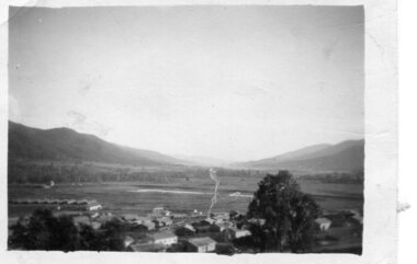
Photograph - Mount Beauty from second gate. View down Kiewa Valley, 1950
... Photograph - Mount Beauty from second gate. View down Kiewa Valley...Black and white photograph - View from second gate down Kiewa Valley showing early buildings. Photograph framed by 6mm white boarder...Handwritten in back of photo in blue ink - View from second gate down Kiewa Valley 1950...Photograph framed by 6mm white boarder Photograph - Mount Beauty from second gate. View down Kiewa Valley ...The new State Electricity Commission construction camp at the head of the Kiewa Valley was for workmen on the second power station in the project expected to be the most modern and best equipped in Australia… In contrast to the early Kiewa days of horses and canvas tents, the new camp, with its modern amenities, compared favourably with any country town. Administration of the Kiewa Scheme was moved from Tawonga to Mount Beauty in 1946. The first house in Mount Beauty, in Hollonds Street, was occupied by the co-op store manager from November 1946. The new Mess Hall at Mt Beauty was opened with much ceremony in early November 1946. The houses up to Nelse street were erected from 1946 onward and then the township was extended beyond Nelse Street in 1950. The workmen's camp was enlarged in 1950 to the extent of providing accommodation for a total of 1,200.Shows early construction of the town of Mt. Beauty surrounded by farmland taken in 1950 during the early stages of construction of the Kiewa Hydro electric SystemBlack and white photograph - View from second gate down Kiewa Valley showing early buildings. Photograph framed by 6mm white boarderHandwritten in back of photo in blue ink - View from second gate down Kiewa Valley 1950mt beauty, kiewa valley, secv -
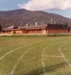
 Stawell Historical Society Inc
Slide, Ian McCann, Lake Bellfield Dam Wall, 1960's
... Looking down the valley at the Dam Wall...Stawell Historical Society Inc 46 Longfield St Stawell grampians Grampians Looking down the valley at the Dam Wall Lake Bellfield Dam Wall Slide Ian McCann ...Looking down the valley at the Dam Wallgrampians -
 Stawell Historical Society Inc
Slide, Ian McCann, Lake Bellfield early construction, 1960's
... Ariel ViewLooking down the valley at the dam wall...Stawell Historical Society Inc 46 Longfield St Stawell grampians Grampians Lake Bellfield Ariel ViewLooking down the valley at the dam wall Lake Bellfield early construction Slide Ian McCann ...Ariel ViewLooking down the valley at the dam wallgrampians, lake bellfield -
 Stawell Historical Society Inc
Slide, Ian McCann, Ariel View of Lake Bellfied looking down the valley showing the wall, 1960's
... Ariel View of Lake Bellfied looking down the valley showing the wall...Ariel View of Lake Bellfied looking down the valley showing the wall...Stawell Historical Society Inc 46 Longfield St Stawell grampians Grampians Ariel View of Lake Bellfied looking down the valley showing the wall Ariel View of Lake Bellfied looking down the valley showing the wall Slide Ian McCann ...Ariel View of Lake Bellfied looking down the valley showing the wallgrampians -
 Bendigo Historical Society Inc.
Slide - DIGGERS & MINING. DIGGERS AND MINERS, 1850s
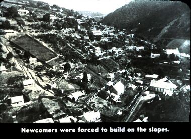
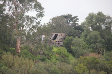
... Picture shows the buildings on a large section of the slope going down into the valley. Markings: 47 994.5 WAL. Used as a teaching aid....Picture shows the buildings on a large section of the slope going down into the valley. Markings: 47 994.5 WAL. Used as a teaching aid. ...Diggers & Mining. Diggers and Miners. Newcomers were forced to build on the slopes. Picture shows the buildings on a large section of the slope going down into the valley. Markings: 47 994.5 WAL. Used as a teaching aid.hanimounteducation, tertiary, goldfields -
 Bendigo Military Museum
Photograph - PHOTOGRAPH, STEAM TRAIN, 1942-1945
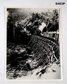
... The bridge is set in a jungle clad valley, down in The Valley are unused logs and poles. This is a copy...The bridge is set in a jungle clad valley, down in The Valley are unused logs and poles. This is a copy Photograph PHOTOGRAPH, STEAM TRAIN Japanese Army, British Army ...see. Cat no 5445.2photograph- black and white, curved wooden trestle bridge, on the bridge is a steam loco pulling freight cars with humans sitting atop. The bridge is set in a jungle clad valley, down in The Valley are unused logs and poles. This is a copyRear of photograph- “THAILAND BURMA RLW BRIDGE MADE BY POWS” “ “I believe was between WAMPO and Kin SIA OK” 122309ww2, pow, burma railway -
Tatura Irrigation & Wartime Camps Museum
Painting - Painting - watercolour - copy, South Africa from Ferry
... Picture is a view looking down into a valley with a pointed top mountain in the centre of the picture. ...Picture is a view looking down into a valley with a pointed top mountain in the centre of the picture. ...Painted by George RosenkranzThe watercolour has a thin black border around it, a 1 cm brown paper frame, a 4cm plus white mat and framed in a brown wooden frame. Picture is a view looking down into a valley with a pointed top mountain in the centre of the picture. Blue skies with a bird flying in right side. front of mountain are a couple of trees, rocks, grass and plants.george rosenkranz, south africa -
 Halls Gap & Grampians Historical Society
Photograph - B/W
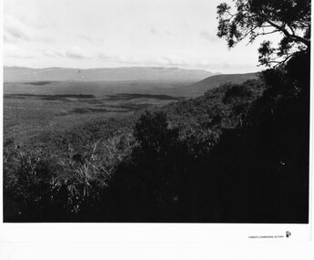
... valley in foreground (shadowed). Mountain range in background. Photographed from a high spot looking down and across the valley. c1960s...SCENERY Grampians Ranges a thick bush covered valley in foreground (shadowed). Mountain range in background. Photographed from a high spot looking down and across the valley. c1960s Photograph B/W ...Photo is of Victoria Valley with the Victoria Range in the background. Photo is typical of promotional photographs taken by Forests Commission at that time.a thick bush covered valley in foreground (shadowed). Mountain range in background. Photographed from a high spot looking down and across the valley. c1960sscenery, grampians ranges -
 Bendigo Military Museum
Photograph - PHOTOGRAPHS - BCOF, c 1948
... Photo taken from the hills looking down into a valley with a town in background. 3.& 4. ...Photo taken from the hills looking down into a valley with a town in background. 3.& 4. ...Photos of fields and towns of Japan taken during the occupation of Japan by BCOF in the late 1940’s. Items in the collection of "Richard William McGILVERY" RAAF. Refer Cat No. 7287P for his service details, photos and awards,Black and white original photos. 1. Picture of 5 large buildings in the foreground and bar in background. 2. Photo taken from the hills looking down into a valley with a town in background. 3.& 4. Same photo of view from hills looking down upon an industrial city/town. 5. High view down on a town in the valley. 6. Ground level picture of fighter planes lined up at an airfield with hangar in background. 7. High picture looking down on fields and town in the background.bcof, japan -
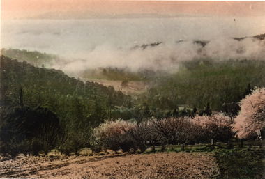 Mt Dandenong & District Historical Society Inc.
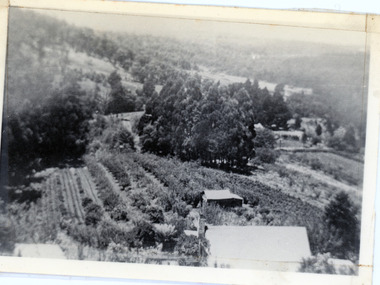
Photograph, Cloud Settling Into Hills
... Coloured photograph looking down valley with flowering fruit trees in foreground and treed hills in distance....Kalorama Kalorama Valley Orchard Coloured photograph looking down valley with flowering fruit trees in foreground and treed hills in distance. ...Looking into the Kalorama Valley with an orchard in the foreground and cloud settling into the hills.Coloured photograph looking down valley with flowering fruit trees in foreground and treed hills in distance.kalorama, kalorama valley, orchard -
 Mt Dandenong & District Historical Society Inc.
Photograph, 'Hillcrest' on Mernda Road, Olinda 1911, 1911
... The house fronted down over the valley of the Sassafras Creek towards Kallista. ...The house fronted down over the valley of the Sassafras Creek towards Kallista. ...Front view of 'Hillcrest' the Devine family home on Mernda Road, Olinda taken in 1911. The road deviation passed to the right of where the photographer was standing. The descriptive text on the reverse of this photograph was hand written by John Lundy-Clarke.“Hillcrest” the home of the Devine family 1911 in Mernda Road now Coonara Road. The road was deviated here to regrade it and the deviation past to the right of the camera. The house fronted down over the valley of the Sassafras Creek towards Kallista. It was close to the spot where the camera stood that the girls practiced the maypole dance in 1911. Vera Devine trained 11 of her mates in the dance here.hillcrest, mernda road, olinda, vera devine, devine family -
 Mt Dandenong & District Historical Society Inc.
Photograph, c1911
... House faced down over the valley of the Sassafras + Perrin Creek towards Kallista. ...House faced down over the valley of the Sassafras + Perrin Creek towards Kallista. ..."Hillcrest" on Mernda Road, Olinda. The home of the Devine Family. c1911 The descriptive text on the reverse of this photograph was hand written by John Lundy-Clarke.“Hillcrest” Mernda Road Olinda 1911. The home of the Devine family. The early settlement road passed to the left of the camera. House faced down over the valley of the Sassafras + Perrin Creek towards Kallista. The deviation to regrade the road passed to the right of the house. It was in front of the house on the left hand side of the picture that Vera Devine and her school mates practiced the maypole dance under her tuition. hillcrest, devine, devine family, mernda road -
 Falls Creek Historical Society
Photograph - Fitgerald's Hut to Shannonvale
... Looking down Middle Creek valley from SEC Camp Bogong High Plains 5. ...Looking down Middle Creek valley from SEC Camp Bogong High Plains 5. ...MEYER COLLECTION - FALLS CREEK PHOTOS In 1947 a determined group of like-minded State Electricity Commission (SEC) staff including Ray Meyer, the chief surveyor of the Kiewa Hydro-Electric Scheme, had a common interest that revolved around the skiing potential of the snow-covered high plains which included what is now the resort of Falls Creek. The six SEC employees, Toni St Elmo, Ray Meyer, Jack Minogue, Lloyd Dunn, Adrian Ruffenacht and Dave Gibson (together with their families) banded together to secretly build a 'hut' that was the first ski lodge at Falls Creek. Using a road built in 1930s to gain access to Falls Creek, their hut project was carried out in secret as efforts by other skiers were blocked by H.H.C. Williams – the engineer in charge of the Hydro Scheme. In 1946 Ray Meyer made a trip to the Lands Office in Melbourne. He came away with a 99-year lease on three acres that was ideally suited for a hut designed by Lloyd Dunn. Adrian Ruffenacht (Design Engineer for the KHS) had suggested where the group should build because of easy access to a spring for water. Much of the building material required was scavenged from derelict huts on the high plains. Due to the need for secrecy, the determined group worked on the hut in the evenings and weekends to avoid detection. During the building period the group had met at Echidna Rock (now known as Eagle Rock) where Skippy St Elmo announced, "This is my favourite ‘Skyline’.” And so the first lodge in the area at Falls Creek Ski Resort came into existence. With the development of the International Poma in the 1970s, the Skyline Lodge, which was sited between the ski-lift’s pole one and pole two, was demolished. However, the legacy of Ray Meyer, Toni St Elmo, Jack Minogue, Lloyd Dunn, Adrian Ruffenacht and Dave Gibson and Skyline lives on in the vibrant atmosphere of Falls Creek Resort. The MEYER COLLECTION documents developments on the Kiewa Hydro Scheme and their life at Falls Creek from the mid 1930s to 1960s.These images are significant because they depict aspects of the life of a pioneering family of Falls Creek and the founders of "Skyline", the first lodge at Falls Creek.A collection of photos related to a sledge trip between Fitzgeralds Hut and Shannonvale in September 1937. 1. L - R:- Cyril Louder, Eileen McEvoy, Bill Burrows (?), Dad Fitzgerald, Olive Sandell (standing in front of Marie Hatters) 2. Little Jimmy Wheeler 3. Fitz's Hut - leaving for Shannonvale 4. Looking down Middle Creek valley from SEC Camp Bogong High Plains 5. Tom Fitzgerald has a nap at Fitz's Hutfalls creek, fitzgerald hut, shannonvale, sledge party 1937 -
 Halls Gap & Grampians Historical Society
Photograph - B/W
... A river meanders down the valley. There are eucalyptus trees in the foreground and two figures can be seen in the left foreground....A river meanders down the valley. There are eucalyptus trees in the foreground and two figures can be seen in the left foreground. ...This is a photo of a lithograph by Eugene von Guerard (1811-1901), "Source of the Wannon", circa 1866-1868. The peaks in the distance are Mr Abrupt and Signal Peak.This is a photo of a lithograph. It is a stylised view of a mountain range with sharp rocky peaks with a valley through the centre. A river meanders down the valley. There are eucalyptus trees in the foreground and two figures can be seen in the left foreground.Photo printers stamp in back is "H/GAP0007 NNNAA"painting, landscape -
 Mt Dandenong & District Historical Society Inc.
Photograph, 1913 View Over Logan's House in Village Settlement, 1913
... Photograph taken in 1913 from Barbers Road showing the view down the valley. Roof in foreground is house on Bob Logan's Lot 28 in the Village Settlement. ...Photograph taken in 1913 from Barbers Road showing the view down the valley. Roof in foreground is house on Bob Logan's Lot 28 in the Village Settlement. ...Photograph taken in 1913 from Barbers Road showing the view down the valley. Roof in foreground is house on Bob Logan's Lot 28 in the Village Settlement. This photograph has a detailed inscription on the back handwritten by John Lundy-Clarke in 1974.1913 view over Logan’s house on Village Settlement Lot 28 taken from Barber’s Road. This is the house that the runaway log leaped over in 1930 to land far down the orchard row beyond the house. “Shiloah” is centre partly behind the clump of trees and the paddocks of Child and Richardsons pioneer selections are in the background. Link Road is centre right.logan, bob logan, robert logan, barbers road, shiloah, child, richardson, link road -
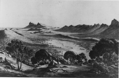
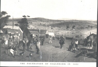 Bendigo Historical Society Inc.
Photograph - WES HARRY COLLECTION: FOUNDATION OF EAGLEHAWK IN 1852, 1852
... The road through the settlement is running down to a broad valley with some low hills in the distance. ...The road through the settlement is running down to a broad valley with some low hills in the distance. ...Photograph of an artwork depicting and early mining camp. In the foreground there is a settlement consisting of tents and some wooden buildings, There are numerous people of all ages on the street and a trooper on horseback. The road through the settlement is running down to a broad valley with some low hills in the distance. There are several tents and rough dwellings at the base of these hills. Along the bottom of the picture is written The foundation of Eaglehawk in 1852.topic, mining, eaglehawk, mining settlement, eaglehawk, diggers, early bendigo -
 Kiewa Valley Historical Society
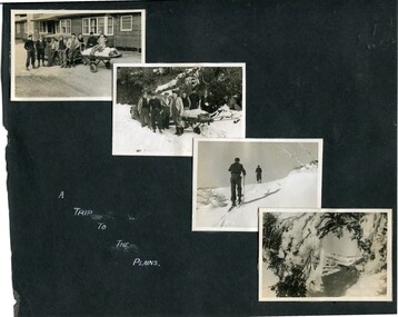
Photographs – Bogong High Plains - Set of 16 black and white photographs mounted back and front on 3 pieces of heavy black card likely removed from a photograph album
... Some pages display a brief description printed in white ink 1. 4 photographs- displayed diagonally across page. 2 pictures of a group of men standing in the snow in front of a car with a loaded trailer behind. 1 photo of skiers. 1 photo of show hanging in tree branches. 2. 2 photographs- showing Upper Kiewa Road with snow in the background 3. 3 photographs- of skiers and 1 photo of 2 of men posing in the snow & 1 photo of 2 men posing shirtless in warmer weather. 4. 2 photographs- arranged diagonally on page showing early buildings and construction at Bogong Village 5. 2 photographs- 1 showing view of Bogong Village from higher up the mountain. 1 showing early Bogong High Plains road 6. 1 photograph- showing view down along Kiewa Valley from higher up in the mountains ...Some pages display a brief description printed in white ink 1. 4 photographs- displayed diagonally across page. 2 pictures of a group of men standing in the snow in front of a car with a loaded trailer behind. 1 photo of skiers. 1 photo of show hanging in tree branches. 2. 2 photographs- showing Upper Kiewa Road with snow in the background 3. 3 photographs- of skiers and 1 photo of 2 of men posing in the snow & 1 photo of 2 men posing shirtless in warmer weather. 4. 2 photographs- arranged diagonally on page showing early buildings and construction at Bogong Village 5. 2 photographs- 1 showing view of Bogong Village from higher up the mountain. 1 showing early Bogong High Plains road 6. 1 photograph- showing view down along Kiewa Valley from higher up in the mountains Photographs – Bogong High Plains - Set of 16 black and white photographs mounted back and front on 3 pieces of heavy black card likely removed from a photograph album ...After World War II, the Kiewa Hydro-Electric Scheme was started in the Kiewa River Valley by the State Electricity Commission of Victoria. On land previously used only for summer cattle grazing in the natural alpine grasslands, the first ski lodge was built in 1948 by workers from the hydro scheme as skiing was a popular recreation. Many of the hydro employees were of European background and had grown up enjoying skiing and snow sports in their homelands and were keen to continue to pursue their winter sports interests. The first lift, a rope tow, was built at Falls Creek in 1951 and the first chairlift in Australia was constructed there in 1957. Two T-Bars were opened in 1961. In 1964, the Victorian Municipal Directory recorded that Falls Creek had 29 ski club lodges and 16 commercial lodges. The area became a popular tourist destination for both winter and summer sports.Employees of the State Electricity Commission of Victoria in the Kiewa River Valley were the earliest skiers on the Bogong High Plains and built one of the first ski lodges at Falls Creek. They were amongst those pivotal in the development of the skiing and tourist industry at Falls Creek and on the Bogong High Plains. Black and white photographs of varying sizes mounted decoratively on heavy black Card. Some pages display a brief description printed in white ink 1. 4 photographs- displayed diagonally across page. 2 pictures of a group of men standing in the snow in front of a car with a loaded trailer behind. 1 photo of skiers. 1 photo of show hanging in tree branches. 2. 2 photographs- showing Upper Kiewa Road with snow in the background 3. 3 photographs- of skiers and 1 photo of 2 of men posing in the snow & 1 photo of 2 men posing shirtless in warmer weather. 4. 2 photographs- arranged diagonally on page showing early buildings and construction at Bogong Village 5. 2 photographs- 1 showing view of Bogong Village from higher up the mountain. 1 showing early Bogong High Plains road 6. 1 photograph- showing view down along Kiewa Valley from higher up in the mountains 1. Handwritten in white ink – A TRIP TO THE PLAINS 2. Handwritten in white ink – UPPER KIEWA ROAD MT FAINTER IN BACKGROUND 3 – 6. No markings bogong village; upper kiewa road; bogong high plains; falls creek; skiers -
 Kiewa Valley Historical Society
Photos - Mt Beauty Buildings in 1973. Set of 8, 1973
... Valley House. The Workman’s Club changed name to the Country Club and has since closed down. ...Valley House. The Workman’s Club changed name to the Country Club and has since closed down. ...The shopping centre in Mt Beauty, both buildings and streetscape, have undergone significant changes since 1973. The kindergarten has undergone extensive remodelling, The Chalet has been replaced by Svarmisk Resort and Accommodation Spa. Tawonga hospital has undergone extensive renovation and is now Mt Beauty Hospital AND Kiewa Valley House. The Workman’s Club changed name to the Country Club and has since closed down. Hospital and Kiewa Valley House now occupy what is shown as a vacant lot opposite the motel which is now called Mt Beauty Motor Inn.The houses in Mt Beauty were brought in by the State Electricity Commission of Victoria when they constructed Mt Beauty Town for their workers building the Kiewa Hydro Electric Scheme. Mt Beauty is unique began as a construction town in the late 1940's.Colour photographs of various buildings in Mt Beauty taken in 1973 1. Workman’s Club 2. View over the pondage 3. Tawonga Hospital (Mt Beauty) 4. Mt Beauty Chalet 5. Mt Beauty Kindergarten 6. The Merjei Motel 7. 8 Valley Avenue 8. Shopping Centre Handwritten in ink on the back of photos 1. Workman’s Club 1973 (after the brick makeover) From the sports oval – the high school is to the right 2. A view over the pond 1973 3. Tawonga Hospital 1973 (Mt Beauty) 4. Mount Beauty Chalet 1973 5. Kindergarten 1973 6. The Merjei Motel 1973 7. Our house at 8 Valley Ave 1973, Owner after us erected the car port, let the front hedge run amok and vanquished the vegetable garden and citrus trees Dad created. 8. Shopping Centre 1973. At the end of the street is the hospital (believe it is now Mt Beauty Bush Nursing Hotel) mt beauty, workman's club, chalet, tawonga hospital -
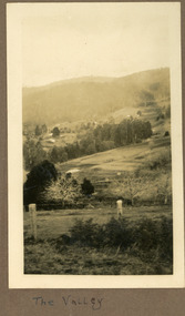 Mt Dandenong & District Historical Society Inc.
Photograph
... The scene is looking down across the Kalorama Valley in the early 1930s. Probably across the Jeeves and Child properties. ...Farndons Community Hall 42 Falls Road Mt Dandenong yarra-valley-and-the-dandenong-ranges The photograph is from the album of Ivy May Child. The scene is looking down across the Kalorama Valley in the early 1930s. ...The photograph is from the album of Ivy May Child. The scene is looking down across the Kalorama Valley in the early 1930s. Probably across the Jeeves and Child properties. Ivy May Child (1910 – 1989) was the daughter of Arthur Edward (Ted) Child (1878 – 1964) and Ethel May Madden (1888 – 1970). Ted Child was the son of Matthew Francis Child (1839 – 1933) and Martha Jeeves (1857 – 1926). He was the grandson of one of the early pioneers Francis Child. Ivy grew up on the family property on Childs Road and took many photographs. Most of these are glued into her photo album. The album covered the years from c1927 – 1932. Ivy married Henry William Burgess (1906 – 1968) in 1944. The photographs remain in their original state in the album with individual copies made. Black and white photograph with a post and wire fence in the foreground , hills in the distance and a cultivated area in the centre.Written below the photograph in the album: The Valleyjeeves, child, kalorama valley, kalorama, valley -
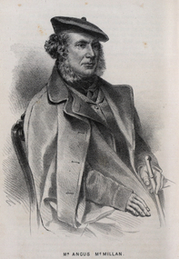 Federation University Historical Collection
Drawing - Image - black and white, Angus McMillan, c1835
... Gippsland was, and still is, dotted with stone cairns tracing his route from Omeo, down the Tambo Valley to the fertile plains where he was to make (and lose) his fortune. ...Gippsland was, and still is, dotted with stone cairns tracing his route from Omeo, down the Tambo Valley to the fertile plains where he was to make (and lose) his fortune. ...Angus McMillan named the Avon River after the river of the same name in his native Scotland. In 1840 he established a pastoral run at Bushy Park, north-west of the township. William Odell Raymond established a run in the area in 1842, and built his house, Strathfieldsaye, during 1848–54. European settlement did not take place without resistance, and in return, massacres were inflicted by Angus McMillan and others on Gunai people, especially between the years of 1840 and 1850. (wikipedia) The first application for the 'Bushy Park' run appears in the “Port Phillip Gazette” on 13 August 1843. It was taken up by Angus McMillan, who also took up the 'Boisdale' run for his employer Lachlan Macalister at the same time. In March 1844 a Licence to occupy the 16,000 acre 'Bushy Park' was granted to McMillan. In the late 1840s Andrew Martin and Matt McCraw built Angus McMillan's Bushy Park homestead. Aboriginal killings in Gippsland area most often were never formally recorded, but lived on in folklore, mainly in place names pinpointing what some historians now refer to as "massacres", and others as "conflicts". There is Boney Point, on Lake Wellington, Butchers Creek, near Metung, Slaughterhouse Gully, at Buchan, Skull Creek, at Lindenow, and, notoriously, Warrigal Creek, at Woodside. "Here, according to a couple of contemporary - though not eyewitness - reports, between 50 and 150 blacks were killed in an orgy of revenge after the murder and mutilation of a leading Scots settler, Ronald Macalister. If anybody had any doubts about the fitness of commemorating McMillan's name, no one voiced them then. Gippsland was, and still is, dotted with stone cairns tracing his route from Omeo, down the Tambo Valley to the fertile plains where he was to make (and lose) his fortune. And where, according to a growing body of opinion, he was to lead the "Highland Brigade", a band of armed settlers, against the Kurnai. History is fiction agreed on, and it is written by the winners. For most of the past 150 years, McMillan has been hailed as a trail-blazing pioneer. The legend began to crumble 20 years ago with publication of new histories, which at first outraged Gippsland historical societies and old residents, but which have gradually changed the way McMillan is viewed. ... Still, not all McMillan's contemporaries agreed with the "Highland Brigade" and its methods. Henry Meyrick, an English-born squatter, wrote to relatives in disgust about his neighbours. He estimated that 450 had been killed, and wrote: "Men, women and children are shot down whenever they can be met with. Some excuse might be found for shooting the men by those who are daily getting their cattle speared, but what they can urge in their excuse who shoot the women and children I cannot conceive." (http://www.theage.com.au/articles/2002/04/26/1019441303552.html, accessed 20 September 2016.) The Gippsland electorate is called 'McMillan' in his honour. Black and white image of a man wearing a coat and beret. He is Scottish born Victorian Squatter Angus McMillan of Bushy Park, Gippsland.angus mcmillan, squatter, aboriginal massacre, bushy park, gunai, avon river, pioneer -
 Stawell Historical Society Inc
Photograph, Postcard set c.1940
... Valley. 10 The Grand Canyon Grampians. This is a popular walk in the Wonderland Range. 11 The Whale’s Mouth Wonderland Range Grampians 12 Relph Peak in the Wonderland Range looking down on the Fyans Valley and Halls Gap 13 Bellfield Peak is part of the Wonderland Range overlooking Halls Gap and the Fyans Valley 14 Gateway of the East Winds on the Wonderland Walk 15 Mackenzie Falls on the Mackenzie River and downstream from Wartook Reservoir. ...Valley. 10 The Grand Canyon Grampians. This is a popular walk in the Wonderland Range. 11 The Whale’s Mouth Wonderland Range Grampians 12 Relph Peak in the Wonderland Range looking down on the Fyans Valley and Halls Gap 13 Bellfield Peak is part of the Wonderland Range overlooking Halls Gap and the Fyans Valley 14 Gateway of the East Winds on the Wonderland Walk 15 Mackenzie Falls on the Mackenzie River and downstream from Wartook Reservoir. ...-1 Stawell Town Hall, with newly constructed clocktower -2 Main Street, Looking west towards the Grampians -3 Stawell from Big Hill, looking west towards the Grampians 4 Cato Lake, looking west towards the railway line. Swimming Club Rooms on the Left, Bandstand on the Right 5 The Gardens Sundial, donated by the family of Edward Simmons who owned the Oriental Gold Mine 6 Central Park Sports Oval looking north to the Grandstand. Cricket match being played. This is the site of the annual running of the Stawell Gift. 7 Pioneers’ Memorial on Big Hill. Built in 1938 and a popular viewing area of Stawell and the Grampians Mountain Range. 8 Sisters Rocks, on London Road and the Western Highway corner. It has been a popular place for graffiti for decades. 9 The Balconies (also known as the “ Jaws of Death ) Mt Victory Grampians. It is near Reids lookout and both have excellent views of the Victoria Valley. 10 The Grand Canyon Grampians. This is a popular walk in the Wonderland Range. 11 The Whale’s Mouth Wonderland Range Grampians 12 Relph Peak in the Wonderland Range looking down on the Fyans Valley and Halls Gap 13 Bellfield Peak is part of the Wonderland Range overlooking Halls Gap and the Fyans Valley 14 Gateway of the East Winds on the Wonderland Walk 15 Mackenzie Falls on the Mackenzie River and downstream from Wartook Reservoir. This is a popular visiting place for tourists. 16 Wartook Reservoir, serving as part of Horsham’s water supply. Black & White Photograph Postcards Setstawell tourism -
 Ballarat Heritage Services
Photograph - Photograph - Colour, Lisa Gervasoni, Remains of Angus McMillan's Bushy Park Home, 2014, 07/06/2014
... Gippsland was, and still is, dotted with stone cairns tracing his route from Omeo, down the Tambo Valley to the fertile plains where he was to make (and lose) his fortune. ...Gippsland was, and still is, dotted with stone cairns tracing his route from Omeo, down the Tambo Valley to the fertile plains where he was to make (and lose) his fortune. ...Angus McMillan was born in 1810 at Glenbrittle in the Isle of Skye. He was one of fourteens sons of Ewan McMillan. Angus McMillan arried i New South Wales in January 1839, and became an overseer for Captai nLachlan Macalister. I n 1839 Angus McMillan travelled south. He settled for a time on Jame MacFarlane's statin at Currawong. IOn 28 May 1839 Angus MacMillan stated travelling southward toward the coast. Angus Macmillan named the Avon River after the river of the same name in his native Scotland. In 1840 he established a pastoral run at Bushy Park, near Maffra. William Odell Raymond established a run in the area in 1842, and built his house, Strathfieldsaye, during 1848–54. European settlement did not take place without resistance, and in return, massacres were inflicted by Angus McMillan and others on Gunai people, especially between the years of 1840 and 1850. (wikipedia) The first application for the 'Bushy Park' run appears in the “Port Phillip Gazette” on 13 August 1843. It was taken up by Angus McMillan, who also took up the 'Boisdale' run for his employer Lachlan Macalister at the same time. In March 1844 a Licence to occupy the 16,000 acre 'Bushy Park' was granted to McMillan. In the late 1840s Andrew Martin and Matt McCraw built Angus McMillan's Bushy Park homestead. Aboriginal killings in Gippsland area most often were never formally recorded, but lived on in folklore, mainly in place names pinpointing what some historians now refer to as "massacres", and others as "conflicts". There is Boney Point, on Lake Wellington, Butchers Creek, near Metung, Slaughterhouse Gully, at Buchan, Skull Creek, at Lindenow, and, notoriously, Warrigal Creek, at Woodside. "Here, according to a couple of contemporary - though not eyewitness - reports, between 50 and 150 blacks were killed in an orgy of revenge after the murder and mutilation of a leading Scots settler, Ronald Macalister. If anybody had any doubts about the fitness of commemorating McMillan's name, no one voiced them then. Gippsland was, and still is, dotted with stone cairns tracing his route from Omeo, down the Tambo Valley to the fertile plains where he was to make (and lose) his fortune. And where, according to a growing body of opinion, he was to lead the "Highland Brigade", a band of armed settlers, against the Kurnai. History is fiction agreed on, and it is written by the winners. For most of the past 150 years, McMillan has been hailed as a trail-blazing pioneer. The legend began to crumble 20 years ago with publication of new histories, which at first outraged Gippsland historical societies and old residents, but which have gradually changed the way McMillan is viewed. ... Still, not all McMillan's contemporaries agreed with the "Highland Brigade" and its methods. Henry Meyrick, an English-born squatter, wrote to relatives in disgust about his neighbours. He estimated that 450 had been killed, and wrote: "Men, women and children are shot down whenever they can be met with. Some excuse might be found for shooting the men by those who are daily getting their cattle speared, but what they can urge in their excuse who shoot the women and children I cannot conceive." (http://www.theage.com.au/articles/2002/04/26/1019441303552.html, accessed 20 September 2016.) The Gippsland electorate is called 'McMillan' in his honour. Photographs of the remains of a timber home used by squatter Angus McMillan at his "Bushy Park" property on the Avon River. angus mcmillan, bushy park, avon river, squater -
 Eltham District Historical Society Inc
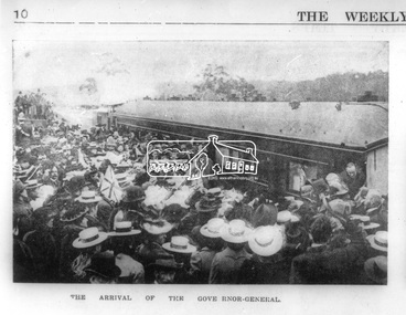
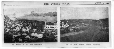
Photograph, Opening of the Railway Line; The arrival of the Governor-General, 6 June, 1902, 1902
... At intervals on the slopes of the surrounding green-mantled hills, patches of brown, freshly tilled soil indicate that for all its serene reposeful-ness Eltham possesses its phases of industrial life as well. Looking down into this valley from the main road which skirts the slope of a hill, distant something less than a quarter of a mile from the railway station is one of the prettiest pieces of scenery in the district. ...At intervals on the slopes of the surrounding green-mantled hills, patches of brown, freshly tilled soil indicate that for all its serene reposeful-ness Eltham possesses its phases of industrial life as well. Looking down into this valley from the main road which skirts the slope of a hill, distant something less than a quarter of a mile from the railway station is one of the prettiest pieces of scenery in the district. ...Published: The opening of the railway line by His Excellency The Governor General, The Weekly Times, June 14, 1902, p10. Governor General was John Hope, Earl of Hopetoun THE HEIDELBERG TO ELTHAM RAILWAY. OPENING CEREMONY. The opening of the railway line from Heidelberg to Eltham took place on the 6th inst. The special train, containing a large number of members of Parliament, including Mr Trenwith, the Minister for Railways, left Prince's Bridge at half-past eleven, and arrived at Eltham at twenty minutes past twelve. The party was accompanied by Mr Fitzpatrick, Acting Commissioner for Railways; Mr Lockhead, the Traffic Manager; and Mr Norman, Engineer for Existing Lines. On arrival, the visitors were entertained at a banquet in the marquee, of which a photograph is given, erected close to the railway station. Mr E. H. Cameron, M.L.A., the member for the district, occupied the chair, and, seated on his right, was Mr Mason, the Speaker of the Legislative Assembly, and on his left the Minister of Rail-ways. After the banquet His Excellency the Governor-General arrived, and was received and welcomed by Mr Cameron, the local State school children singing the National Anthem. The Governor-General, in declaring the line open, said that he felt highly honored at being asked to perform the opening ceremony, and he trusted that the railway would be a source of great convenience to the inhabitants of the district. He was sorry to say that this would be the last opportunity he would have of seeing them. It cost him a great deal to leave them. (Hear, hear.) He had a great many friends amongst all sections of the community, and he could hardly bear to trust himself to speak about leaving them. (Hear, hear.) He was sorry Lady Hopetoun was on the high seas, and unable to accompany him that day. Mr Cameron thanked his Excellency for performing the opening ceremony, and hoped the trip home would have the effect of restoring His Excellency to good health again. In replying. Lord Hopetoun thanked them sincerely for the cordial vote of thanks. He hoped Providence would shower her blessings over them, and that they would have a series of good seasons. He would always keep a warm corner in his heart for the people of Victoria. (Loud cheers.) THE COUNTRY. In our illustrations, views are given of a couple of sections of the new line, and glimpses of the surrounding country are shown. The line is eight miles in length, and cost £51,000 in construction. Eltham, which is the terminus, possesses many of the features that go to make a favorite holiday resort. It is a quiet picturesque little hamlet, snugly ensconced on the slope of one of many sombre-tinted hills by which it is sur-rounded. Even when viewed under ad-verse conditions one could not fail to be-impressed with the natural, rugged beauty of the place. It is situated about sixteen miles from Melbourne, and the line takes a circuitous course through a continuation of pretty undulating country. At intervals on the slopes of the surrounding green-mantled hills, patches of brown, freshly tilled soil indicate that for all its serene reposeful-ness Eltham possesses its phases of industrial life as well. Looking down into this valley from the main road which skirts the slope of a hill, distant something less than a quarter of a mile from the railway station is one of the prettiest pieces of scenery in the district. Verdure-clad hills ascend on all sides, whilst beneath stretches a broad expanse of carpet-like green sward, dotted here and there with picturesque homesteads, each with its patches of tilled soil. In the township itself the dwelling-houses are comparatively few, the larger portion of the inhabitants residing in the scattered homesteads. Eltham is as yet only in its youth, but energetic and un-tiring public men can effect wonders in a community's prosperity, and Eltham, whatever other real or imaginary advantages it may lay claim to, certainly possesses this one. The railway is the result of their endeavor. 1902 'THE HEIDELBERG TO ELTHAM RAILWAY.', Weekly Times (Melbourne, Vic. : 1869 - 1954), 14 June, p. 14. , viewed 26 Sep 2018, http://nla.gov.au/nla.news-article221230719This photo forms part of a collection of photographs gathered by the Shire of Eltham for their centenary project book,"Pioneers and Painters: 100 years of the Shire of Eltham" by Alan Marshall (1971). The collection of over 500 images is held in partnership between Eltham District Historical Society and Yarra Plenty Regional Library (Eltham Library) and is now formally known as the 'The Shire of Eltham Pioneers Photograph Collection.' It is significant in being the first community sourced collection representing the places and people of the Shire's first one hundred years.Digital image Negative black and white film 120 6x9 format 2 stripsAgfa APX 100sepp, shire of eltham pioneers photograph collection, eltham, heidelberg-eltham railway extension, earl of hopetoun, john hope, opening day, railway line construction -
 Eltham District Historical Society Inc
Photograph, The Weekly Times, Opening of the Heidelberg-Eltham Railway Line, 6 June 1902, 1902
... At intervals on the slopes of the surrounding green-mantled hills, patches of brown, freshly tilled soil indicate that for all its serene reposeful-ness Eltham possesses its phases of industrial life as well. Looking down into this valley from the main road which skirts the slope of a hill, distant something less than a quarter of a mile from the railway station is one of the prettiest pieces of scenery in the district. ...At intervals on the slopes of the surrounding green-mantled hills, patches of brown, freshly tilled soil indicate that for all its serene reposeful-ness Eltham possesses its phases of industrial life as well. Looking down into this valley from the main road which skirts the slope of a hill, distant something less than a quarter of a mile from the railway station is one of the prettiest pieces of scenery in the district. ...Reproduced from "The Weekly Times", 14th June 1902, page 10. 06 Jun 1902 Cross Reference Photo No.(s): 602, 604 Source: La Trobe Library and National Library, Canberra THE HEIDELBERG TO ELTHAM RAILWAY. OPENING CEREMONY. The opening of the railway line from Heidelberg to Eltham took place on the 6th inst. The special train, containing a large number of members of Parliament, including Mr Trenwith, the Minister for Railways, left Prince's Bridge at half-past eleven, and arrived at Eltham at twenty minutes past twelve. The party was accompanied by Mr Fitzpatrick, Acting Commissioner for Railways; Mr Lockhead, the Traffic Manager; and Mr Norman, Engineer for Existing Lines. On arrival, the visitors were entertained at a banquet in the marquee, of which a photograph is given, erected close to the railway station. Mr E. H. Cameron, M.L.A., the member for the district, occupied the chair, and, seated on his right, was Mr Mason, the Speaker of the Legislative Assembly, and on his left the Minister of Rail-ways. After the banquet His Excellency the Governor-General arrived, and was received and welcomed by Mr Cameron, the local State school children singing the National Anthem. The Governor-General, in declaring the line open, said that he felt highly honored at being asked to perform the opening ceremony, and he trusted that the railway would be a source of great convenience to the inhabitants of the district. He was sorry to say that this would be the last opportunity he would have of seeing them. It cost him a great deal to leave them. (Hear, hear.) He had a great many friends amongst all sections of the community, and he could hardly bear to trust himself to speak about leaving them. (Hear, hear.) He was sorry Lady Hopetoun was on the high seas, and unable to accompany him that day. Mr Cameron thanked his Excellency for performing the opening ceremony, and hoped the trip home would have the effect of restoring His Excellency to good health again. In replying. Lord Hopetoun thanked them sincerely for the cordial vote of thanks. He hoped Providence would shower her blessings over them, and that they would have a series of good seasons. He would always keep a warm corner in his heart for the people of Victoria. (Loud cheers.) THE COUNTRY. In our illustrations, views are given of a couple of sections of the new line, and glimpses of the surrounding country are shown. The line is eight miles in length, and cost £51,000 in construction. Eltham, which is the terminus, possesses many of the features that go to make a favorite holiday resort. It is a quiet picturesque little hamlet, snugly ensconced on the slope of one of many sombre-tinted hills by which it is sur-rounded. Even when viewed under ad-verse conditions one could not fail to be-impressed with the natural, rugged beauty of the place. It is situated about sixteen miles from Melbourne, and the line takes a circuitous course through a continuation of pretty undulating country. At intervals on the slopes of the surrounding green-mantled hills, patches of brown, freshly tilled soil indicate that for all its serene reposeful-ness Eltham possesses its phases of industrial life as well. Looking down into this valley from the main road which skirts the slope of a hill, distant something less than a quarter of a mile from the railway station is one of the prettiest pieces of scenery in the district. Verdure-clad hills ascend on all sides, whilst beneath stretches a broad expanse of carpet-like green sward, dotted here and there with picturesque homesteads, each with its patches of tilled soil. In the township itself the dwelling-houses are comparatively few, the larger portion of the inhabitants residing in the scattered homesteads. Eltham is as yet only in its youth, but energetic and un-tiring public men can effect wonders in a community's prosperity, and Eltham, whatever other real or imaginary advantages it may lay claim to, certainly possesses this one. The railway is the result of their endeavor. 1902 'THE HEIDELBERG TO ELTHAM RAILWAY.', Weekly Times (Melbourne, Vic. : 1869 - 1954), 14 June, p. 14. , viewed 26 Sep 2018, http://nla.gov.au/nla.news-article221230719This photo forms part of a collection of photographs gathered by the Shire of Eltham for their centenary project book,"Pioneers and Painters: 100 years of the Shire of Eltham" by Alan Marshall (1971). The collection of over 500 images is held in partnership between Eltham District Historical Society and Yarra Plenty Regional Library (Eltham Library) and is now formally known as the 'The Shire of Eltham Pioneers Photograph Collection.' It is significant in being the first community sourced collection representing the places and people of the Shire's first one hundred years.Digital image 35mm B&W negativesepp, shire of eltham pioneers photograph collection, eltham, heidelberg-eltham railway extension -
 Kiewa Valley Historical Society
18 small black and white photographs of the Bogong High Plains, 1948
... Photo 4 Ruined Castle - Looking Down Valley December 1948. Photo 5 - Mt. McKay from Ruined Castle October 1948. ...Photo 4 Ruined Castle - Looking Down Valley December 1948. Photo 5 - Mt. McKay from Ruined Castle October 1948. ...These photos of the Bogong High Plains were all taken by Ronald George Thorn who was a cadet engineer with the State Electricity Commission. He worked on the Kiewa scheme from 1948 to 1950 doing overhead line construction and maintenance plus electrical design and drawing work. They are from his personal collection and a record of his time in the Kiewa area.Pictorial history of personal involvement in the the early days of the Kiewa Scheme.18 small black and white photographs all taken on the Bogong High Plains.Photo 1 Wallace's Hut. Photo 2 Ruined Castle - Looking towards Pretty Valley December 1948. Photo 3 Ruined Castle - Looking towards Pretty Valley December 1948. Photo 4 Ruined Castle - Looking Down Valley December 1948. Photo 5 - Mt. McKay from Ruined Castle October 1948. Photo 6 View from Rocky Valley Camp October 1948. Photo 7 Mt. Feather Top from Ruined Castle October 1948. Photo 8 View from Ruined Castle looking downwards towards Beauty October 1948. Photo 9 Rocky River from gauging station October 1948. Photo 10 Rocky Valley River from main road October 1948. Photo 11 View along little Arthur Fire Track October 1948. Photo 12 View along main road. Looking towards Beauty Valley October 1948. Photo 13 View from Little Arthur Fire Track October 1948. Photo 14 Frying Pan Spur from Rocky Valley Road October 1948. Photo 15 Mt. Bogong from Big Hill Fire Track October 1948. Photo 16 View from Big Hill Fire Track October 1948. Photo 17 Mt. Feathertop from Ruined Castle October 1948. Photo 18 Mt. Fainter from Ruined Castle October 1948. (All of the above is hand written on the back of photos in ink). bogong high plains; r g thorn; secv; kiewa hydro electric scheme; pictorial history -
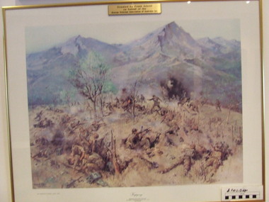 Waverley RSL Sub Branch
Print Kapyong, Kapyong
... But late on 24 April, with their position now untenable, the Australians were forced into a fighting withdrawal down a ridge to the valley, where they rejoined the brigade. ...But late on 24 April, with their position now untenable, the Australians were forced into a fighting withdrawal down a ridge to the valley, where they rejoined the brigade. ...On 23 April, the 3rd Battalion, Royal Australian Regiment (3 RAR), under the command of Lieutenant Colonel Bruce Ferguson, and the 2nd Battalion, Princess Patricia's Canadian Light Infantry, occupied prominent hills on either side of the seven-kilometre-wide valley, where a small tributary joined the Kapyong River. Also forward were headquarters units, tanks and artillery. The 1st Battalion, Middlesex Regiment, were to the rear. Early in the evening, retreating South Koreans streamed past the Commonwealth position, with Chinese forces closely intermingled. Soon afterwards a platoon of American tanks supporting 3 RAR was overrun. The Kapyong valley was too large an area to defend with the forces available, and the brigade was spread very thinly. Throughout the night the Chinese repeatedly pressed the Australian positions, attacking in waves over their own dead and wounded. At dawn, A Company, under the command of Major Bernard "Ben" O'Dowd, found that the Chinese had infiltrated its position, but a counter-attack was able to eject them. Meanwhile B Company, which had spent the night on a hill near the riiver, discovered Chinese occupying some old bunkers on a small knoll. Hand-to-hand fighting ensued with grenades and bayonets. C Company, under the command of Captain Reg Saunders, was in position to reinforce both A and B Companies. "Major O'Dowd then directed the radio operator to contact anyone. The American 1st Marine Division answered but their operator refused to believe who our operator was speaking for. Major O'Dowd took the phone and demanded to speak to the commanding officer. The general in charge of the [Marine] division came on the phone and told O'Dowd we didn't exist as we had been wiped out the night before. Major O'Dowd said, 'I've got news for you, we are still here and we are staying here.'" Private Patrick Knowles, 3 RAR, on the morning of 24 April 1951 Fighting continued throughout the day with the Australians holding their positions, and the Chinese also engaging D Company. But late on 24 April, with their position now untenable, the Australians were forced into a fighting withdrawal down a ridge to the valley, where they rejoined the brigade. Their withdrawal was supported by New Zealand artillery from the 16th Field Regiment. Having found the Canadian position unassailable, the Chinese made no further attacks. By the afternoon of 25 April the road through to the Canadians had been cleared of Chinese and 2 PPCLI was relieved by US Army units. On Anzac Day 1951, the Australians rested after a long fight. Thirty-two Australians were killed and 53 were wounded for their part in stalling the Chinese advance and preventing Seoul from falling into enemy hands. Lieutenant Colonel Bruce Ferguson was awarded the Distinguished Service Order for his skilful leadership, and the Australian and Canadian battalions both received United States Presidential Distinguished Unit Citations for their part in the battle. http://www.awm.gov.au/exhibitions/korea/operations/kapyong/Print of painting of action in Kapyong Korea in wooden frame under glassDonated by Frank Arnold on behalf of Korean Veterans Association of Australia inc.korea, kapyong, 3rar -
 Kiewa Valley Historical Society
Alpine Observer Newspaper - 23 Oct. 1980 x2, 23 Oct. 1980
... Valley supplying an education for the children of the local farming community. The Bogong Hotel at Tawonga, the Tawonga Butter Factory and the town of Mt Beauty articles were printed providing up to date historical information on prime locations nearby. Of interest as the Hotel has burnt down ...The Tawonga Primary School celebrated its centenary with a program including a fete, sports, family dance and combined church service over the weekend of the 25th - 26th Oct. 1980. The newspaper covers the Alpine Shire and included further articles that would interest visitors to the centenary.Tawonga School was one of the earliest schools in the Kiewa Valley supplying an education for the children of the local farming community. The Bogong Hotel at Tawonga, the Tawonga Butter Factory and the town of Mt Beauty articles were printed providing up to date historical information on prime locations nearby. Of interest as the Hotel has burnt down and the Butter factory no longer exists. Alpine Observer newspaper dated Thursday, 23 rd October 1980 with a sketch of the school and articles regarding the Centenary of the Tawonga School on the front page. (The paper consists of 12 pages ie. 6 sheets) 2 copies On page 4 is an article on the history of the Bogong Hotel at Tawonga On page 5 is an article on the history of the Tawonga Butter Factory and an article on the township of Mt Beauty.newspaper articles; tawonga primary school; bogong hotel; tawonga butter factory -
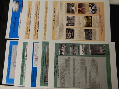 Kiewa Valley Historical Society
Posters - 10 in the Set, The Famous Bogong School; Beyond the Gate - (up and down); A Good Life; The Precursors; Great Expectations; Windows to Yesterday; Movement in the Mountains; Life wasn't meant to be Easy; There are Places I'll Remember, 1998
... Valley Runs 8. Roads constructed 9. The 1930's 10. Pre 1930 The Famous Bogong School; Beyond the Gate - (up and down); A Good Life; The Precursors; Great Expectations; Windows to Yesterday; Movement in the Mountains; Life wasn't meant to be Easy; There are Places I'll Remember Posters - 10 in the Set ...These posters were produced or a display during the Mt Beauty Music Festival in 1998. They cover the history of the Kiewa Valley from the early days, farming and the Kiewa Hydro Electric Scheme.These posters summarise the history of the Kiewa Valley and were compiled using publications, memories and documents. The posters are clear and useful for displaySee KVHS 0164 A4 glossy cardboard posters: Beige, Blue or Green with photos and writing of the history of different aspects of the Kiewa Valley. 1. Bogong 2. Mt Beauty 3. Bogong 4. The Early Days 5. The Early Years 6. The Kiewa Hydro Story 7. The Kiewa Valley Runs 8. Roads constructed 9. The 1930's 10. Pre 1930bogong state school; bogong village; secv; khes; tawonga; surveyors; mt beauty; camps; kiewa valley -
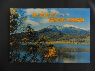 Kiewa Valley Historical Society
Booklet - Mt Beauty and the Kiewa Scheme x2
... Mt Beauty; Kiewa Scheme; Tawonga; Bogong; Clover Dam; Kiewa Valley; Bogong High Plains A fold down booklet postcard size of 12 colored photos - back to back of Mt Beauty, the Kiewa Scheme & surrounds. ...This booklet was produced to advertise Mt Beauty, the Kiewa Scheme & surrounding areas to visitors / tourists. The photos cover Falls Creek with snow, lifts and skiers - one with Spion Kopje Lodge. Also Tawonga Camping ground, Bogong Village, Mt Beauty Chalet, the Control panel at Kiewa Power Station, Clover Dam at No. 3 Power Station, the road to Falls Creek and a view of Mt Beauty township. The photos indicate what Mt Beauty and the Kiewa Valley and High Plains looked like c1950's during the construction of the Kiewa Hydro Electric Scheme. The area was recognised and encouraged as a tourist attraction especially Falls Creek enabling comparison with later photos and ideas. A fold down booklet postcard size of 12 colored photos - back to back of Mt Beauty, the Kiewa Scheme & surrounds. They fold in to form a front photo with title and a back card for stamp & address of addressee. On the back of the front photo are a few paragraphs describing the beauty, history and 'things to do' in the area for the visitor / tourist. mt beauty; kiewa scheme; tawonga; bogong; clover dam; kiewa valley; bogong high plains