Showing 41 items matching " eastern lines"
-
 Bendigo Historical Society Inc.
Document - TYSON'S LINE - EASTERN LINES
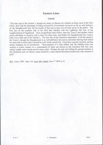
... TYSON'S LINE - EASTERN LINES...... Eastern Lines...Document TYSON'S LINE - EASTERN LINES ...BHS CollectionTyped carbon copy and typed copy of General notes on the lines East of the Hustlers. Lines mentioned are: Hustler's, New Chum, Lightning Hill, Tysons, Slaughteryard, Isabella Mine, Ironstone Hill Reef, Nicholson Reef, on which a mine owned by a man named Stevenson mined a fair amount of gold. Ref. Anon; 1899. Spec. Ed. Aust. Min. Stand. June 1st 1899: p 61. Notes prepared by Albert Richardson.mining, parish map, tyson's line, eastern lines, hustler's, new chum, slaughteryard line, lightning hill, tyson's, isabella mine, ironstone hill reef, nicholson reef, mr stevenson, aust min stand 1 june 1899 -
 Victorian Railway History Library
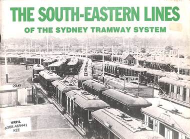
Book, Keenan, David R, The South-Eastern Lines: Of The Sydney Tramway System, 1982
... The South-Eastern Lines: Of The Sydney Tramway System....The South-Eastern Lines: Of The Sydney Tramway System. Book Keenan, David R. ...A history of the Sydney tramway system with focus on the lines in South-Eastern lines including electric and some steam trams.ill, maps, p.72.non-fictionA history of the Sydney tramway system with focus on the lines in South-Eastern lines including electric and some steam trams.trams -- new south wales -- sydney -- history, tramway rolling stock - sydney - history -
 Ballarat Tramway Museum
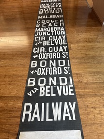
Functional object - Destination Roll, NSW Department of Road Transport and tramways, Sydney Eastern Suburbs
... See page 76 of Kennan, "The Eastern Lines" See reverse of original catalogue worksheet for listing of destinations. ...See page 76 of Kennan, "The Eastern Lines" See reverse of original catalogue worksheet for listing of destinations. ...Destination roll for South East part of Sydney on Linen 13 sections joined by sewing with destinations painted on in capital letters and colours. At top of blind, 3 new section shave been sewn on. See page 76 of Kennan, "The Eastern Lines" See reverse of original catalogue worksheet for listing of destinations. See p76 of "The Eastern Lines", David Keenan, Transit Press, 1989 p32 fold out of "Tramways of Sydney", Kennan, Transit Press, 1985 reprint.tram, trams, sydney, eastern suburbs, destination roll -
 Kiewa Valley Historical Society
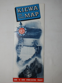
Map - Kiewa on the Map, Guide to Kiewa Hydro-Electric Project
... Conducted tours of the Kiewa area are operated by Eastern Road Lines Pty. Ltd., Albury...Conducted tours of the Kiewa area are operated by Eastern Road Lines Pty. Ltd., Albury The SECV constructed the KHES and controlled all roads within the Kiewa works area. ...Published by the SECV in 1950. They controlled the roads from Mt Beauty to the Bogong High Plains and all other roads within the Kiewa works area. The roads are not open to general tourist traffic. Conducted tours of the Kiewa area are operated by Eastern Road Lines Pty. Ltd., AlburyThe SECV constructed the KHES and controlled all roads within the Kiewa works area.Large colored map folded in half and then in 3. Front third is mostly blue and white with titles.. When opened the cover has black and white photos beside it with print and 'Please Note'. Also in the other half, a 'Road Map to Kiewa' showing the south eastern side of Australia, mostly yellow (the land) and blue (the sea). Inside the map is a close up map of "Ground Plan of Kiewa Hydro Electric Project' with a 'Key Map Showing Distances'.map of kiewa 1950, khes map -
 Melbourne Tram Museum
Document - Folder with papers, Folder of memos and directions, c1940
... Folder of Memos and directions (htd3207i1> htd3207i8) - Air raid precautions, covering painting, respirators, sheds, tools, kits, shelters, stacks , blackouts, trenches, emergency, air raid shelters (htd3207i9> htd3207i16) - Accidents, covering accidents and derailments, (htd3207i17) - Bridges – inspection of Victoria St bridge (htd3207i18) - Cable tracks, covering tarring, patching, top dressing of cable tracks (htd3207i19> htd3207i21) - Cartage, covering hired trucks, cartage of wood blocks, spoil, sleepers (htd3207i22> htd3207i23) - Contracts, blank page (no image) - Councils, covering track opening, storm water drain, bad roads (htd3207i24) - Costs, covering maintenance costs, construction costs, wet weather (htd3207i25> htd3207i26) - Depots, covering inspections, storage, paving, telephones, mail (htd3207i27> htd3207i30) - Derailments, covering controls, reports (htd3207i31) - Drainage (htd3207i32) - Eastern Lines, covering loading platforms, crossovers, work orders (htd3207i33> htd3207i34) - Eastern Lines Reconstruction (htd3207i35> htd3207i37) - Eastern Line Maintenance (htd3207i38> htd3207i40) - Estimates (htd3207i41) - Employment (htd3207i42) - Footscray Lines (htd3207i43) - Instructions (htd3207i44) - Journals, covering Engineering Journal and magazines (htd3207i45) - Materials – General, covering frames & covers, unloading stores, packing plates, petrol allowance, ashes at Preston workshops, electrodes, sleepers (htd3207i46> htd3207i50) - Maintenance – General, covering loading platforms, inspections, work orders, paving (htd3207i51> htd3207i57) - Northern Lines, covering greasing of curves, crossovers, loading platforms (htd3207i58> htd3207i61) - Northern Lines – Reconstruction, covering crossings, welding machines (htd3207i62> htd3207i64) - Northern Lines – Maintenance, covering repairs, crossings, lifting programme, fencing, curves, track inspection, repairs (htd3207i65> htd3207i70) - New Lines (htd3207i71> htd3207i80) - Plant – General (htd3207i81> htd3207i94) - Plant – Concrete Mixers (htd3207i95) - Plant – Motor Vehicles (htd3207i96> htd3207i100) - Plant – Rollers (htd3207i101> htd3207i103) - Plant – Grinders (htd3207i104) - Plant – Grinders & Scrubbers (htd3207i105> htd3207i110) - Plant – Compressors and Tie Tampers (htd3207i111) - Plant – Cleaner Cars (htd3207i112> htd3207i114) - Plant – Loaders (htd3207i115) - Plant – Tools (htd3207i116> htd3207i117) - Plant – Miscellaneous (htd3207i118) - Per Way – General (htd3207i119> htd3207i121) - Public Utilities (htd3207i122> htd3207i123) - Reconstruction – General (htd3207i124> htd3207i126) - Railways (htd3207i127> htd3207i129) See \dbtext\hawthorn\photo_collections\3207_Folder for scanned images....Melbourne Tram Museum 8 Wallen Road Hawthorn melbourne Trams tramways Instructions Folder of Memos and directions (htd3207i1> htd3207i8) - Air raid precautions, covering painting, respirators, sheds, tools, kits, shelters, stacks , blackouts, trenches, emergency, air raid shelters (htd3207i9> htd3207i16) - Accidents, covering accidents and derailments, (htd3207i17) - Bridges – inspection of Victoria St bridge (htd3207i18) - Cable tracks, covering tarring, patching, top dressing of cable tracks (htd3207i19> htd3207i21) - Cartage, covering hired trucks, cartage of wood blocks, spoil, sleepers (htd3207i22> htd3207i23) - Contracts, blank page (no image) - Councils, covering track opening, storm water drain, bad roads (htd3207i24) - Costs, covering maintenance costs, construction costs, wet weather (htd3207i25> htd3207i26) - Depots, covering inspections, storage, paving, telephones, mail (htd3207i27> htd3207i30) - Derailments, covering controls, reports (htd3207i31) - Drainage (htd3207i32) - Eastern Lines, covering loading platforms, crossovers, work orders (htd3207i33> htd3207i34) - Eastern Lines Reconstruction (htd3207i35> htd3207i37) - Eastern Line Maintenance (htd3207i38> htd3207i40) - Estimates (htd3207i41) - Employment (htd3207i42) - Footscray Lines (htd3207i43) - Instructions (htd3207i44) - Journals, covering Engineering Journal and magazines (htd3207i45) - Materials – General, covering frames & covers, unloading stores, packing plates, petrol allowance, ashes at Preston workshops, electrodes, sleepers (htd3207i46> htd3207i50) - Maintenance – General, covering loading platforms, inspections, work orders, paving (htd3207i51> htd3207i57) - Northern Lines, covering greasing of curves, crossovers, loading platforms (htd3207i58> htd3207i61) - Northern Lines – Reconstruction, covering crossings, welding machines (htd3207i62> htd3207i64) - Northern Lines – Maintenance, covering repairs, crossings, lifting programme, fencing, curves, track inspection, repairs (htd3207i65> htd3207i70) - New Lines (htd3207i71> htd3207i80) - Plant – General (htd3207i81> htd3207i94) - Plant – Concrete Mixers (htd3207i95) - Plant – Motor Vehicles (htd3207i96> htd3207i100) - Plant – Rollers (htd3207i101> htd3207i103) - Plant – Grinders (htd3207i104) - Plant – Grinders & Scrubbers (htd3207i105> htd3207i110) - Plant – Compressors and Tie Tampers (htd3207i111) - Plant – Cleaner Cars (htd3207i112> htd3207i114) - Plant – Loaders (htd3207i115) - Plant – Tools (htd3207i116> htd3207i117) - Plant – Miscellaneous (htd3207i118) - Per Way – General (htd3207i119> htd3207i121) - Public Utilities (htd3207i122> htd3207i123) - Reconstruction – General (htd3207i124> htd3207i126) - Railways (htd3207i127> htd3207i129) See \dbtext\hawthorn\photo_collections\3207_Folder for scanned images. ...Folder of Memos and directions (htd3207i1> htd3207i8) - Air raid precautions, covering painting, respirators, sheds, tools, kits, shelters, stacks , blackouts, trenches, emergency, air raid shelters (htd3207i9> htd3207i16) - Accidents, covering accidents and derailments, (htd3207i17) - Bridges – inspection of Victoria St bridge (htd3207i18) - Cable tracks, covering tarring, patching, top dressing of cable tracks (htd3207i19> htd3207i21) - Cartage, covering hired trucks, cartage of wood blocks, spoil, sleepers (htd3207i22> htd3207i23) - Contracts, blank page (no image) - Councils, covering track opening, storm water drain, bad roads (htd3207i24) - Costs, covering maintenance costs, construction costs, wet weather (htd3207i25> htd3207i26) - Depots, covering inspections, storage, paving, telephones, mail (htd3207i27> htd3207i30) - Derailments, covering controls, reports (htd3207i31) - Drainage (htd3207i32) - Eastern Lines, covering loading platforms, crossovers, work orders (htd3207i33> htd3207i34) - Eastern Lines Reconstruction (htd3207i35> htd3207i37) - Eastern Line Maintenance (htd3207i38> htd3207i40) - Estimates (htd3207i41) - Employment (htd3207i42) - Footscray Lines (htd3207i43) - Instructions (htd3207i44) - Journals, covering Engineering Journal and magazines (htd3207i45) - Materials – General, covering frames & covers, unloading stores, packing plates, petrol allowance, ashes at Preston workshops, electrodes, sleepers (htd3207i46> htd3207i50) - Maintenance – General, covering loading platforms, inspections, work orders, paving (htd3207i51> htd3207i57) - Northern Lines, covering greasing of curves, crossovers, loading platforms (htd3207i58> htd3207i61) - Northern Lines – Reconstruction, covering crossings, welding machines (htd3207i62> htd3207i64) - Northern Lines – Maintenance, covering repairs, crossings, lifting programme, fencing, curves, track inspection, repairs (htd3207i65> htd3207i70) - New Lines (htd3207i71> htd3207i80) - Plant – General (htd3207i81> htd3207i94) - Plant – Concrete Mixers (htd3207i95) - Plant – Motor Vehicles (htd3207i96> htd3207i100) - Plant – Rollers (htd3207i101> htd3207i103) - Plant – Grinders (htd3207i104) - Plant – Grinders & Scrubbers (htd3207i105> htd3207i110) - Plant – Compressors and Tie Tampers (htd3207i111) - Plant – Cleaner Cars (htd3207i112> htd3207i114) - Plant – Loaders (htd3207i115) - Plant – Tools (htd3207i116> htd3207i117) - Plant – Miscellaneous (htd3207i118) - Per Way – General (htd3207i119> htd3207i121) - Public Utilities (htd3207i122> htd3207i123) - Reconstruction – General (htd3207i124> htd3207i126) - Railways (htd3207i127> htd3207i129) See \dbtext\hawthorn\photo_collections\3207_Folder for scanned images.trams, tramways, instructions -
Whitehorse Historical Society Inc.
Map, Railway map of Victoria, 1912
... On verso map of suburban lines with eastern line as far as Croydon and Bayswater. ...On verso map of suburban lines with eastern line as far as Croydon and Bayswater. key numbers on map linked to pages of a timetable. ...Detailed map of railways in Victoria including adjacent areas of New South Wales.Detailed map of railways in Victoria including adjacent areas of New South Wales. Also shows 'principal coach routes'. On verso map of suburban lines with eastern line as far as Croydon and Bayswater. key numbers on map linked to pages of a timetable.Detailed map of railways in Victoria including adjacent areas of New South Wales.maps, railways -
 Bendigo Military Museum
Photograph - RA Svy Project C4 Aerodist Operation, Eastern Arnhem Land, NT, 1967
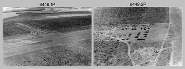
... From July to October 1967 the aircraft was attached to Central Comd Fd Svy Unit (Adelaide - Major Don Ridge) on Project C4 eastern-Arnhem Land NT, where 317 Aerodist lines measuring 17,300 line miles were successfully completed. ...From July to October 1967 the aircraft was attached to Central Comd Fd Svy Unit (Adelaide - Major Don Ridge) on Project C4 eastern-Arnhem Land NT, where 317 Aerodist lines measuring 17,300 line miles were successfully completed. ...This is a set of 30 photographs of Royal Australian Survey Corps (RA Svy) personnel from Central Comd Fd Svy Unit (Adelaide) on Aerodist survey operation - Project C4 in Eastern Arnhem Land, Northern Territory in 1967. Photos of personnel were taken either at the operations base at Numbulwar or the main base at Gove (Nhulunbuy). RA Svy conducted nineteen Aerodist operations for 12 years from 1964 to 1975. Aerodist MRC2 was a tellurometer-based system adapted for aircraft to accurately measure distances between non-intervisible ground survey stations, using the aircraft as an intermediate station. Lower order geodetic results could be achieved by survey network trilateration. The measured distances between stations formed survey networks from which each station’s latitude and longitude was computed. Aerodist MRC2 was RA Svy’s major horizontal control survey tool for mainly medium scale topographic mapping (scale 1:100,000 Class A being spatially accurate to within 50 metres) in PNG, northern NT, north-west WA, Kalimantan Barat (West) Indonesia, Sumatra Indonesia, Gulf of Carpentaria and Cape York, QLD. In 1967, the Aerodist MRC2 Master equipment was installed in the aircraft featured in this set of photos, Executive Air Services’ (Essendon VIC) Grand Aero Commander VH-EXX. It was the same aircraft type and company contracted to Division of National Mapping for Aerodist MRC2 surveys. From July to October 1967 the aircraft was attached to Central Comd Fd Svy Unit (Adelaide - Major Don Ridge) on Project C4 eastern-Arnhem Land NT, where 317 Aerodist lines measuring 17,300 line miles were successfully completed. This was the most productive Aerodist project thus far. The most common helicopter used by RA Svy up to 1972 was the civilian Bell 47G-2 and the Sioux Light Observation Helicopters (LOH), the Australian Army’s equivalent featured in this photo set. These light observation helicopters had a limiting load carrying capacity of up to about 500 pounds. By comparison, one Aerodist team including two people weighed up to 1,500 pounds. Source: Royal Australian Survey Corps – Aerodist Years 1964-1975 by Peter Jensen. Refer to Item 9061.26P for more photos taken during this Aerodist survey operation.This is a set of 30 photographs of Royal Australian Survey Corps (RA Svy) personnel on Aerodist survey operations in Eastern Arnhem Land, Northern Territory in 1967. The photographs are on 35mm negative film and scanned at 96 dpi. They are part of the Army Survey Regiment’s Collection. .1) to .4) - black & white, 20th August 1967, Project C4 Aerodist Operations Base - Numbulwar, NT. .5) - Photo, black & white, 1967. Probable wrecked Indonesian fishing vessel. .6) to .8) - Photo, black & white, 1967. Unidentified survey operations base, L to R: unidentified personnel. .9) - Photo, black & white, 1967. Unidentified survey operations base, unidentified soldier driving a Haflinger 4x4 Light utility vehicle. .10) - Photo, black & white, 1967. Unidentified survey operations base, L to R: unidentified technician. .11) - Unidentified technician reading two survey altimeters to compute corrections to the measured distances for atmospheric refraction and to compute the sea level distances from the slope distances aircraft to the ground stations. .12) - Photo, black & white, 1967. Survey operations base, L to R: unidentified (x3), W01 Pat Wood BEM, unidentified. .13) to .16) - Photo, black & white, 1967. Unidentified personnel operating remote Aerodist MRC2 ground instruments. .17) to .18) - Photo, black & white, 1967. Unknown RA Svy office location. .19) to .20) - Photo, black & white, 1967. Aerodist MRC2 Master equipment. .21) to .22) - Photo, black & white, 1967. Aero Commander VH-EXX probably at Gove, NT, Central Comd Fd Svy Unit (Adelaide) – OC Major Don Ridge. .23) to .25) - Photo, black & white, 1967. Aero Commander VH-EXX probably at Gove, NT. Unidentified personnel. .26) - Photo, black & white, 1967. Aero Commander VH-EXX probably at Gove, NT. Aerodist antenna pods are visible on the aircraft. .27) to .29) - Photo, black & white, 1967. Australian Army Sioux Light Observation Helicopter (LOH) probably at Gove, NT. .30) - Photo, black & white, 1967. Panelled U337 survey station, visible as a white cross on aerial identification photo..1P to .2P – date and location on edge of film negative. .5P to .28P – no annotations .29P - annotated in white ‘RW-JEP Gove NT’ .30P - annotated in white ‘U337 Spool No1 Jun67’royal australian survey corps, rasvy, army survey regiment, army svy regt, fortuna, asr, aerodist, surveying, central comd fd svy unit -
 Bendigo Military Museum
Photograph - RA Svy Project C4 Aerodist Operation, Eastern & Western Arnhem Land, NT, 1967, 1968
... From July to October 1967 the aircraft was attached to Central Comd Fd Svy Unit (Adelaide - Major Don Ridge) on Project C4 eastern-Arnhem Land NT, where 317 Aerodist lines measuring 17,300 line miles were successfully completed. ...From July to October 1967 the aircraft was attached to Central Comd Fd Svy Unit (Adelaide - Major Don Ridge) on Project C4 eastern-Arnhem Land NT, where 317 Aerodist lines measuring 17,300 line miles were successfully completed. ...This is a set of 26 photographs of Royal Australian Survey Corps (RA Svy) personnel from Central Comd Fd Svy Unit (Adelaide) on Aerodist survey operation - Project C4 in Eastern Arnhem Land, Northern Territory in 1967 (photos .4P to .26P) and in Western Arnhem Land, Northern Territory in 1968 (photos .1P to .3P). Photos of personnel were taken either at the operations base at Numbulwar or the main base at Gove (Nhulunbuy). RA Svy conducted nineteen Aerodist operations for 12 years from 1964 to 1975. Aerodist MRC2 was a tellurometer-based system adapted for aircraft to accurately measure distances between non-intervisible ground survey stations, using the aircraft as an intermediate station. Lower order geodetic results could be achieved by survey network trilateration. The measured distances between stations formed survey networks from which each station’s latitude and longitude was computed. Aerodist MRC2 was RA Svy’s major horizontal control survey tool for mainly medium scale topographic mapping (scale 1:100,000 Class A being spatially accurate to within 50 metres) in PNG, northern NT, north-west WA, Kalimantan Barat (West) Indonesia, Sumatra Indonesia, Gulf of Carpentaria and Cape York, QLD. In 1967, the Aerodist MRC2 Master equipment was installed in the aircraft featured in this set of photos, Executive Air Services’ (Essendon VIC) Grand Aero Commander VH-EXX. It was the same aircraft type and company contracted to Division of National Mapping for Aerodist MRC2 surveys. From July to October 1967 the aircraft was attached to Central Comd Fd Svy Unit (Adelaide - Major Don Ridge) on Project C4 eastern-Arnhem Land NT, where 317 Aerodist lines measuring 17,300 line miles were successfully completed. This was the most productive Aerodist project thus far. The most common helicopter used by RA Svy up to 1972 was the civilian Bell 47G-2 and the Sioux Light Observation Helicopters (LOH), the Australian Army’s equivalent featured in this photo set. These light observation helicopters had a limiting load carrying capacity of up to about 500 pounds. By comparison, one Aerodist team including two people weighed up to 1,500 pounds. In 1968, after completion of the Kimberley Aerodist Operation project, the Aerodist system in VH-EXX was immediately deployed to western-Arnhem Land NT for Central Comd Fd Svy Unit (Adelaide - Major Don Ridge) to complete the mapping control across northern NT from mid-July to October. The Aerodist MRC2 Remote antenna seen in Photos .24P to .26P is mounted on a 20 foot pole tower. The antenna direction was controlled by wires/ropes to the two arms under the dish at right angles. The antenna elevation could be changed to the vertical for aircraft height checks as seen in photo .25P. Source: Royal Australian Survey Corps – Aerodist Years 1964-1975 by Peter Jensen. Refer to Item 6449.30P for more photos taken during these Aerodist survey operations.This is a set of 26 photographs of Royal Australian Survey Corps (RA Svy) personnel on Aerodist survey operations in Eastern Arnhem Land, Northern Territory in 1967 and Western Arnhem Land, Northern Territory in 1968. The photographs are on 35mm negative film and scanned at 96 dpi. They are part of the Army Survey Regiment’s Collection. .1) to .2) – Photo, black & white, 1968, unidentified soldier with an opened can of food, possibly bully beef. .3) – Photo, black & white, 15 Aug 1968, aerial view of terrain taken from a helicopter in vicinity of MILINGIMBI SIERRA. .4) – Photo, black & white, 1967, aerial view of an island taken from a helicopter. .5) & .6) – Photo, black & white, 1967, unidentified soldier driving a Haflinger 4x4 Light utility vehicle with trailer. .7) – Photo, black & white, 1967, unidentified surveyors taking vertical measurements with a leveling instrument and staff. .8) – Photo, black & white, 1967, Australian Army Sioux Light Observation Helicopter (LOH) with float removed. .9) to .11) – Photo, black & white, 1967, Australian Army Sioux Light Observation Helicopter (LOH) with floats. .12) – Photo, black & white, 1967, civilian Bell 47G-2 helicopter (Australian Army Sioux LOH equivalent) refuelled. .13) – Photo, black & white, 1967, survey station on coastline surrounded by white plastic aerial photographic identification panels lined with rocks. .14) & .15) – Photo, black & white, 1967, soldier (possibly a signaller from RA Sigs) operating a radio. .16) – Photo, black & white, 1967, Central Comd Fd Svy Unit Operations Section tent, Main Base Gove (Nhulunbuy) L to R: SPR Harry Dunn, WO1 Pat Wood BEM. .17) – Photo, black & white, 1967, Central Comd Fd Svy Unit Operations Section tent, Main Base Gove (Nhulunbuy) L to R: unidentified, WO1 Pat Wood BEM. .18) – Photo, black & white, 1967, Central Comd Fd Svy Unit Operations Section, Main Base Gove (Nhulunbuy), unidentified Australian Army Catering Corps cook preparing meals. .19) – Photo, black & white, 1967, Central Comd Fd Svy Unit Operations Section, Main Base Gove (Nhulunbuy) mess tent in readiness for meals. .20) – Photo, black & white, 1967, Bank of batteries in transit boxes undergoing recharging using generators. .21) – Photo, black & white, 1967, A topographic survey identification plaque set in a concrete block being weighed using a set of scales hanging from slaughtering gallows. .22) – Photo, black & white, 1967, CPL (Geoff or Gary) Larkin operating the remote Aerodist MRC2 ground instrument at Veronica Island, located north of Nhulunbuy. .23) – Photo, black & white, 1967, L to R: CPL (Geoff or Gary) Larkin with unidentified surveyor operate the remote Aerodist MRC2 ground instrument at Venica Island, located north of Nhulunbuy. .24) & .25 – Photo, black & white, 1967, The Aerodist MRC2 Remote antenna. .26) – Photo, black & white, 1967, The Aerodist MRC2 Remote antenna.The following photos are annotated in black ink on edge of film negative: .3P – ’15 Aug ’68, 2000’, 1-C18 ’68 MILINGIMBI SIERRA’ .4P – ’U462’ .8P – ‘1-C3/67 Float Removed’ .13P – ‘U477 10-C3/67 .20P - ‘2-C3/67 Bank of Chargers’ .21P - ‘3-C3/67 Gallows & Scales’ .22P - ‘0462 VERONICA ISLAND NT, CPL Larkin’ .23P - ‘0462 VERONICA ISLAND NT’ .24P - ‘4-C3/67 20’ Aerodist Tower’ .25P - ‘5-C3/67 20’ Aerodist Tower’ .26P - ‘6-C3/67 20’ Aerodist Tower’royal australian survey corps, rasvy, army survey regiment, army svy regt, fortuna, asr, aerodist, surveying, central comd fd svy unit -
 Orbost & District Historical Society
railways envelope, C 1980's
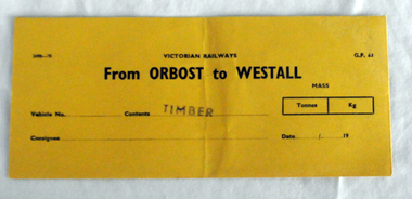
... Westall railway station is located on the Pakenham and Cranbourne lines in Victoria, Australia. It serves the south-eastern Melbourne suburb of Clayton South, opening on 6 February 1951. ...Westall railway station is located on the Pakenham and Cranbourne lines in Victoria, Australia. It serves the south-eastern Melbourne suburb of Clayton South, opening on 6 February 1951. ...This item was used by Victorian Railways 1970's/1980's. It was used at Orbost Railway Station for the consignment of timber from Orbost to Westall.. Westall was a major timber-receiving depot near Dandenong, Victoria. Westall railway station is located on the Pakenham and Cranbourne lines in Victoria, Australia. It serves the south-eastern Melbourne suburb of Clayton South, opening on 6 February 1951. Westall station was opened as a workers only platform on 16 October 1954. It was provided for the adjacent Martin & King railway coachbuilding factory. The station was opened to the public on 1 June 1959 when all trains on the line began stopping there. The Bairnsdale-Orbost railway was opened in 1916 to serve the agricultural and timber industry. Because of the decline in traffic and heavy operating costs, the line was finally closed in August, 1987. Orbost Railway Station was opened on Monday 10 April 1916 as the terminus of the Orbost railway line, and closed in 1987. The station was located on the west side of the Snowy River despite the town of Orbost being on the east side of the river, in order to save on the costs of a bridge over the river, which at the time had highly variable levels. This item is associated with the history of the Orbost-Bairnsdale railway line and therefore reflects the role that the rail line played in the social and economic history of Orbost.An unused brown/buff coloured goods/freight consignment envelope used by Victorian Railways, this one for timber from Orbost to Westall. It is DL size.2497-78 VICTORIAN RAILWAYS G.F 63 From ORBOST to WESTALL MASS Tonnes kg Vehicle No Contents TIMBER Consignee Date orbost-bairnsdale-railway westall -
 Orbost & District Historical Society
account, 1st September 1928
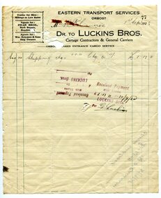
... A white paper account with black print and green lines for Luckin Bros, Cartage Conbtractors & General Carriers to R. Cameron. It is headed "Eastern Transport Services"....A white paper account with black print and green lines for Luckin Bros, Cartage Conbtractors & General Carriers to R. Cameron. It is headed "Eastern Transport Services". account Luckins Bros ...Robert Pullar Cameron was a Shire Councillor for many years. He married Penuel Hossack and had a family of James, Flora, Penuel and Alex.This document is an example of early book keeping records and is a useful research tool.A white paper account with black print and green lines for Luckin Bros, Cartage Conbtractors & General Carriers to R. Cameron. It is headed "Eastern Transport Services".on back left hand corner -"Cheque Corner......."luckins-bros-general-carriers account cameron-robert-pullar -
 Flagstaff Hill Maritime Museum and Village
Container, Griffiths Bros, 1900 - 1940
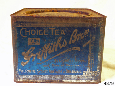
... Griffiths signs let the rail travelers know the distance to where their tea could be enjoyed, with distances being shown as “miles to Griffiths Tea”, These signs were well known along the eastern states railway lines. flagstaff hill warrnambool shipwrecked-coast flagstaff-hill flagstaff-hill-maritime-museum maritime-museum shipwreck-coast flagstaff-hill-maritime-village Choice Tea Griffith Bros 7lb net in white on a blue label Tea container tin Griffiths blue tin with round lid, not hinged. 7lbs net Container Container Griffiths Bros. ...In 1873, English grocer James Griffiths migrated to Melbourne with his wife and cousin in order to start a tea business. By 1875 Griffiths Brothers Teas had become a sensation, providing tea, coffee, cocoa and chocolate all over Australia. The Sydney outlet of the Melbourne-based company was built in 1915. In a memorable advertising campaign, a series of Griffiths signs were situated at varying intervals along the rail lines on fences and building, designed to allow travellers to count down the miles until they could drink up. In 1925, James Griffiths was killed by a train and the tea company was sold to Robur Tea, which itself lasted until 1974. Griffiths’ death meant downsizing within the company with the Sydney building being transferred to the Sydney City Council, who then leased it back to Griffiths Teas. The tea craze was over by 1965, and Griffiths relinquished control of the building to a variety of tenants. Griffiths tea became an intrical part of Australian life, during the late 19th to mid 20th century. The company became a household name through the clever use of outdoor advertising with their blue and white enamel “Griffiths Tea” signs. These were visible Australia wide on railway fences, stations and other buildings. Griffiths signs let the rail travelers know the distance to where their tea could be enjoyed, with distances being shown as “miles to Griffiths Tea”, These signs were well known along the eastern states railway lines. Tea container tin Griffiths blue tin with round lid, not hinged. 7lbs net Choice Tea Griffith Bros 7lb net in white on a blue labelflagstaff hill, warrnambool, shipwrecked-coast, flagstaff-hill, flagstaff-hill-maritime-museum, maritime-museum, shipwreck-coast, flagstaff-hill-maritime-village -
 Eltham District Historical Society Inc
Document - Certificate of Title, Landata, Vol. 4930 Fol. 985900, Crown Portion 15 Section 5, Parish of Nillumbik, County of Evelyn, 1925
... lines. Subsequent lots are then sold off with the development of the Stokes Orchard Estate residential development in the mid to late 1970s. A History of the Development of Crown Allotment 15, Section 5, Parish of Nillumbik – Stokes Orchard Crown Allotment 15, Section 5, Parish of Nillumbik (CA15) is a square allotment of 158 acres or approximately a quarter of a square mile. It lies just beyond the eastern...lines. Subsequent lots are then sold off with the development of the Stokes Orchard Estate residential development in the mid to late 1970s. A History of the Development of Crown Allotment 15, Section 5, Parish of Nillumbik – Stokes Orchard Crown Allotment 15, Section 5, Parish of Nillumbik (CA15) is a square allotment of 158 acres or approximately a quarter of a square mile. It lies just beyond the eastern ...(Cancelled) Certificate of Title originally issued for Crown Portion 15, Section 5 to Robert David Taylor, of Eltham, County of Evelyn, Farmer, 13 March 1925. It is with this title that the land allotment was subdivided into 48 lots. The title shows the issuance to Robert David Taylor with encumbrance placed upon it by immediate former owner, Hugh Patrick Keogh, a former member for Gippsland and Melbourne Real Estate Agent. Following Taylor's death in 1934 the title passes to his Executors, sons Robert David Taylor of Bible Street, Eltham and William McLelland Vance Taylor of Northcote. The property is then sold to Frank Stokes who develops the Stokes Orchard. Compulsory acquisitions by the Melbourne Metropolitan Board of Works and State Electricity Commission show provisions of easemenst for town water supply and high voltage power transmission lines. Subsequent lots are then sold off with the development of the Stokes Orchard Estate residential development in the mid to late 1970s. A History of the Development of Crown Allotment 15, Section 5, Parish of Nillumbik – Stokes Orchard Crown Allotment 15, Section 5, Parish of Nillumbik (CA15) is a square allotment of 158 acres or approximately a quarter of a square mile. It lies just beyond the eastern end of Pitt Street, south of Nyora Road to the northern end of Eucalyptus Road and extends east from Eucalyptus Road to Reynolds Road. The topography of CA15 is generally steep, sloping up to a hill near the centre of the land, the ridgeline passing through the properties along the southern side of Diosma Road. Eucalyptus Road is a straight north-south road with its northern end at the north west corner of CA15. Until the end of the 1970s this road was an un-named Government Road and was largely not open to traffic. With residential development in the 1970s the road was constructed, and the council allocated the name obviously in recognition of the predominant species of the local bushland. CA15 was purchased from the Crown by George D’Arley Boursiquot, a prominent Melbourne printer, on 28th October 1852. On November 23, 1922, former Member for Gippsland and Melbourne Real Estate Agent, Hubert Patrick Keogh purchased the allotment then sold it March 13, 1925, to local farmer, Robert David Taylor, a former Shire of Eltham Councillor (1911-1920) and Shire President (1919). Taylor had extensive land holdings stretching west towards Bible Street and Main Road. The Taylor home was situated at the top of the hill in Bible Street at present day 82 Bible Street. At the time of Taylor’s purchase in 1925, CA15 was subdivided into 48 lots that could be described as small rural properties or large residential lots. A typical lot size was one hectare or 2.5 acres. The subdivision created two roads, Nyora Road, and Diosma Road, each following an irregular alignment between Eucalyptus and Reynolds Roads. However, the lots were not sold off separately nor were the roads constructed. The land effectively remained as one parcel for many further years. Robert David Taylor died November 30, 1934, and probate was granted to his son of the same name, Robert David Taylor of Bible Street, Salesman and William McLelland Vance Taylor of 73 Emmeline Street, Northcote, Clerk, with the transfer of the land into their names on July 8, 1935. Frank Stokes worked as a qualified accountant at Kennons leather factory in Burnley, while living at 1 Thomas Street, Mitcham. He suffered from migraines and wanted to return to working the land (he had previously worked on farms and orchards since coming to Australia from England in 1926, both in WA and Vic.). He first travelled to the district by train in July 1942 to find land with the intention to establish an orchard. By chance he met Arthur Bird of Bird Orchard (bounded by Pitt Street, Eucalyptus Road, and Wattle Grove) and they got talking over their common interest. Arthur put Frank up for the night and pointed out the land, 158 acres- part of the Taylor Estate- £900, Crown Allotment 15, Section 5, Parish of Nillumbik (CA15) somewhat diagonally opposite Bird Orchard. Stokes applied through the Riverina Agency to purchase the land who in turn applied for permission from Canberra to sell as there was a new government regulation introduced during the Second World War banning land sales except for immediate production. Stokes obtained a loan on his Mitcham house of £600 @ 5% and paid £450 deposit with quarterly payments of £15 spread over 5 years. Stokes was assisted and advised by Arthur Bird who farmed the neighbouring orchard. In early 1943 Stokes took possession and would catch the train out to Eltham on Fridays after work and began building a hut on the corner of Nyora Road and the Government Road (Eucalyptus Road) for shelter and to lock up tools. He established an orchard on the central western part of the land through the centre of which ran a natural waterway (part of the present-day linear park) and was able to pay a neighbour (Hawkins) to help with clearing and fencing 25 acres, and with a horse and single furrowed plough, planted approximately 2,500 fruit trees - cherries, peaches, plums, almonds, pears, apricots and lemons as well as a few apples and oranges; a massive task. Aerial photographs from the 1940s through to the 1990s clearly show the orchard with most of the larger CA15 site remaining as natural bushland. A huge problem was hares and rabbits eating all the new buds off the tiny trees. As well as laying poison he painted the trees with a mixture of cow manure and lime, often working by moonlight. Procurement of wire and wire netting was difficult because of the war but after much effort he obtained a permit from the Agricultural Department for supplies in March 1944. In February 1945 Stokes applied for a permit to build a “packing shed” as no house building was allowed. It was to be 33 feet x 21 feet and cost £312. It was constructed mostly from second-hand materials, which were hard to obtain, especially iron for roofing. Stokes finished work at Kennons on October 31, 1945, and in March 1946 he sold the family home at Mitcham for £1,230 plus £170 for furniture. On May 15, 1946, title to the CA15 property was issued to Frank Howard Alfred Stokes, Orchardist and Gladys Ethel Stokes, Married Woman, both of Pitt Street, Eltham. The family of five then moved into the very unfinished “packing shed” at Eltham, which was a struggle to weatherproof. Eventually rooms were divided off and lined with hessian bags and whitewashed. Their income was firewood (cut and sold), selling rockery stones and cut Sweet Bursaria. (It was discovered during the 1940s that Sweet Bursaria contained the sunscreen compound Aesculin. The RAAF utilised this compound from Sweet Bursaria during WW2 for pilots and gunners.) The orchard’s first fruit sale was a half-case of Le Vanq peaches in December 1947 for the price of 8 shillings. In 1956 plans for house were drawn and Glen Iris bricks purchased (1956 Olympic Rings variant). The building of the house commenced in 1957 - 12 feet of original packing shed was removed – and was completed in 1959. Water was connected from newly built pressure storage on the property at the end of 1959 and the electricity connection for the first time at 3pm on April 29, 1960. The house remains to present day (somewhat modified) at 1 Nyora Road, home to Nyora Studio Gallery. On occasions, spare remnants of the 1956 bricks have been known to be unearthed in gardens on the estate as they were utilised by Frank Stokes to fill in rabbit holes. On May 26, 1950, a parcel of land was compulsorily acquired by the Melbourne and Metropolitan Board of Works on the hilltop to establish an easement for a high-level service reservoir to augment Eltham’s water supply. The project also included pipe tracks for the necessary water mains. The reservoir has now been superseded by higher level water tanks east of Reynolds Road and its former site is now a public reserve. On November 27, 1964, the State Electricity Commission served notice to compulsorily acquire a further parcel through the eastern part of the land for a major electricity transmission line that augmented supply from the La Trobe Valley to Melbourne. The easement was registered February 11, 1966. The easement was widened July 18, 1969 for a second transmission line to be constructed. In 1971 Melbourne Metropolitan Planning Scheme amendments adopted Nyora Road as the boundary between a residential zone to the north and a rural zone to the south. This determined the future development of the land. In the mid-1970s the Shire of Eltham divided the orchard into numerous rate-able parcel lots, the 48 lots having been established in 1925 and the subsequent rates assessment proved unsustainable for Stokes. He commenced selling lots outside the boundary of the orchard, north of Diosma and South of Nyora. However shortly later the land between Nyora and Diosma Roads and west of the electricity easement was sold and subdivided into residential lots, a housing development by Macquarie Builders and marketed as the Stokes Orchard Estate. New streets were created, and most were named after trees, although one, Stokes Place, commemorates the former owners. The development was undertaken in two stages; Stage 1 (1975) encompassing Scarlet Ash Court, Ironbark Close and Peppermint Grove bounded by Nyora and Eucalyptus roads and Stage 2 (1978) encompassing Stokes Place, Orchard Way, The Crest and The Lookout bound by Nyora and Diosma roads. The developer, Macquarie Builders went bankrupt shortly after the release of Stage 2 leaving many purchasers to fend for themselves and arrange for their own independent builders. There were also difficulties with sewerage for the land immediately south of Diosma Road and so the conventional residential lots were abandoned in favour of larger lots. The development of Orchard Way, The Crest and The Lookout did not proceed as planned and the proposed lots were incorporated into five-acre parcels instead. These included a low-density group housing development by the Graves family and the award winning Choong House (1983) with Gordon Ford developed garden immediately next door situated on the ridge of the hill nestled amongst the original bush, Eucalypt trees and Sweet Bursaria. In 1994, Nillumbik Shire Council applied Significant Environment and Significant Landscape overlays upon the properties on the south side of Diosma Road to ensure protection of this natural bush garden environment. With the arrival of the sewer along Diosma Road in the 1990s, most of these five-acre parcels have since been subdivided multiple times. The Choong house presently sits on a 2.7-acre property, which in 2022 Nillumbik Council nominated for Cultural Significance Heritage protection and is considered potentially significant at State level. The Stokes family were also associated with the Eltham Christian Church. In the 1970s this church had met in temporary premises in Eltham. Lots of the original 1925 subdivision remained south of Nyora Road and a number of these lots were utilized for the Eltham Christian School, which was established by the Eltham Christian Church in 1981. The school operated on this site until 2000. The premises are now used by The Vine Baptist Church. By the mid-1980s the whole of CA15 had been developed for residential and school purposes, except for the sections north of Diosma Road and between the transmission lines and Reynolds Road. Sewerage issues had been resolved for the section north of Diosma Road and in 1987 it was in the process of being subdivided into residential lots. The development coincided with the discovery of colonies of the rare and endangered Eltham Copper Butterfly on the site. This resulted in a community and political campaign to save the butterfly habitat. With the co-operation of the land developer the subdivision was altered to create two bushland reserves in the critical butterfly habitat areas. In the late 1980s the State Government was investigating options for establishing a metropolitan ring road link between Diamond Creek and Ringwood. The chosen route was adjacent to Reynolds Road and so this created a freeze on development of CA15 between Reynolds Road and the electricity easement. The ring road proposal was eventually abandoned, and this part of the land was subdivided into low density residential lots. Diosma Road has been discontinued at the electricity easement and the eastern part incorporated into View Mount Court with access from Reynolds Road. The whole of CA15 has now been developed for residential or associated purposes, ranging from conventional density to quite low density south of Nyora Road. Some remnants of the orchard remain, a few cherry trees on the Graves property and a lone apple tree in Stokes Place. The butterfly reserves comprise significant areas of remnant bushland. Linear reserves through the estate link with central Eltham via the Woodridge linear reserve and with Research along the electricity easement. CA15 as it exists today has a complicated history of rural use, Government acquisition, urban development, and community action. References: • “Stokes Orchard, an incomplete history”; Russell Yeoman with Doug Orford • Correspondence, Beryl Bradbury (nee Stokes) • Aerial Photographs, 1931-1991, Landata (landata.vic.gov.au) • Certificate of Title, Vol. 4930 Fol. 985900 • Plan Number LP 10859 neil webster collection, diosma road, eltham copper butterfly, eucalyptus road, ironbark close, nyora road, peppermint grove, power transmission lines, reynolds road, scarlet ash court, stokes orchard estate, stokes place, woodridge estate, frank stokes, certificate of title -
 Otway Districts Historical Society
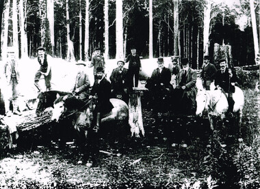
Photograph, Railway Survey Camp, Beech Forest, 4 Apr 1897, 4 April 1897
... lines were examined. In a memorandum to the Minister for Railways, dated 23rd March, 1897, the Engineer-in-Chief recommended that the eastern and longer route via Lardner's Track be adopted. ...lines were examined. In a memorandum to the Minister for Railways, dated 23rd March, 1897, the Engineer-in-Chief recommended that the eastern and longer route via Lardner's Track be adopted. ...On the 18th August, 1896, the question of selecting localities for the permanent survey of a narrow-gauge line to Beech Forest from Colac was mooted. Two potential lines were examined. In a memorandum to the Minister for Railways, dated 23rd March, 1897, the Engineer-in-Chief recommended that the eastern and longer route via Lardner's Track be adopted. The second route, while identical from Colac to Gellibrand River, differed. By a more direct route the Beech Forest terminus is reached 5 miles sooner and cost approximately L24,500 less. The direct line would also serve a larger lot of settlers and would obtain a larger lot of traffic than the alternate proposal. The Parlimentary Standing Committee on Railways examined the proposal in situ and recommended that the direct route from Gellibrand to Beech Forest should be adopted and the Lardner's Track route should be abandoned at once.Photograph, Railway Survey Camp, 4 April 1897. Inspection of alternative routes by Parliamentary Committee on Railways.People named in the photograph.beech forest; railway; survey; victorian parliament; calcutt; fraser; e.h. cameron; d. mciville; a. harris; n. mcinnes; j.s. white; j. wood; t. baker; j. gardner; t.g. watson; standing committee; -
Port Melbourne Historical & Preservation Society
Photograph - Resiting eastern kiosk, Station Pier, Port Melbourne, Ron Laing, 1993
... Lines truck park. It was later extended to the east to create a 90 seat restaurant, known at the turn of the century as Cafe Limani. Part of Ron Laing's collection of photographs taken around Port Melbourne over a thirteen year period. Donated to the PMH&PS by the photographer. piers and wharves - station pier ron laing A set of 18 colour photographs showing the re-siting of the eastern ...The kiosk was turned sideways to make room for the TT Lines truck park. It was later extended to the east to create a 90 seat restaurant, known at the turn of the century as Cafe Limani. Part of Ron Laing's collection of photographs taken around Port Melbourne over a thirteen year period. Donated to the PMH&PS by the photographer.A set of 18 colour photographs showing the re-siting of the eastern kiosk on Station Pier (later Cafe Limani) c 1993piers and wharves - station pier, ron laing -
Port Melbourne Historical & Preservation Society
Photograph - Eastern kiosk, Development of TT Lines truck parking area, Station Pier, Port Melbourne, 1992
... Eastern kiosk, Development of TT Lines truck parking area, Station Pier, Port Melbourne...Photos show the development of TT Line's truck parking area at Station Pier in 1992. .08 - Eastern Kiosk Photograph Eastern kiosk, Development of TT Lines truck parking area, Station Pier, Port Melbourne ...Thirteen (13) colour photographs taken by Lyn Allison as part of Bayside Development Action Group. Photos show the development of TT Line's truck parking area at Station Pier in 1992. .08 - Eastern Kioskpiers and wharves - station pier, tt-line co pty ltd, abel tasman, beacon, station pier gatehouse, london family hotel, swallow & ariell ltd -
Port Melbourne Historical & Preservation Society
Photograph - Station Pier and Eastern kiosk, Development of TT Lines truck parking area, Station Pier, Port Melbourne, 1992
... Station Pier and Eastern kiosk, Development of TT Lines truck parking area, Station Pier, Port Melbourne...Photos show the development of TT Line's truck parking area at Station Pier in 1992. .13 - Station Pier gatehouse and eastern Kiosk Photograph Station Pier and Eastern kiosk, Development of TT Lines truck parking area, Station Pier, Port Melbourne ...Thirteen (13) colour photographs taken by Lyn Allison as part of Bayside Development Action Group. Photos show the development of TT Line's truck parking area at Station Pier in 1992. .13 - Station Pier gatehouse and eastern Kioskpiers and wharves - station pier, tt-line co pty ltd, abel tasman, beacon, station pier gatehouse, london family hotel, swallow & ariell ltd -
 Flagstaff Hill Maritime Museum and Village
Container - Tea Container, Griffiths Bros, 1900 - 1940
... Griffiths signs let the rail travelers know the distance to where their tea could be enjoyed, with distances being shown as “miles to Griffiths Tea”, These signs were well known along the eastern states railway lines. flagstaff hill warrnambool shipwrecked-coast flagstaff-hill-maritime-museum maritime-museum shipwreck-coast flagstaff-hill-maritime-village Griffiths Bros Tea Container Tin Tea Container Choice Tea Griffith Bros 7lb net in white on a blue label Tea container tin Griffiths blue tin with round lid, not hinged. 7lbs net Container Tea Container Griffiths Bros. ...In 1873, English grocer James Griffiths migrated to Melbourne with his wife and cousin in order to start a tea business. By 1875 Griffiths Brothers Teas had become a sensation, providing tea, coffee, cocoa and chocolate all over Australia. The Sydney outlet of the Melbourne-based company was built in 1915. In a memorable advertising campaign, a series of Griffiths signs were situated at varying intervals along the rail lines on fences and building, designed to allow travellers to count down the miles until they could drink up. In 1925, James Griffiths was killed by a train and the tea company was sold to Robur Tea, which itself lasted until 1974. Griffiths’ death meant downsizing within the company with the Sydney building being transferred to the Sydney City Council, who then leased it back to Griffiths Teas. The tea craze was over by 1965, and Griffiths relinquished control of the building to a variety of tenants. Griffiths tea became an intrical part of Australian life, during the late 19th to mid 20th century. The company became a household name through the clever use of outdoor advertising with their blue and white enamel “Griffiths Tea” signs. These were visible Australia wide on railway fences, stations and other buildings. Griffiths signs let the rail travelers know the distance to where their tea could be enjoyed, with distances being shown as “miles to Griffiths Tea”, These signs were well known along the eastern states railway lines. Tea container tin Griffiths blue tin with round lid, not hinged. 7lbs net Choice Tea Griffith Bros 7lb net in white on a blue labelflagstaff hill, warrnambool, shipwrecked-coast, flagstaff-hill-maritime-museum, maritime-museum, shipwreck-coast, flagstaff-hill-maritime-village, griffiths bros, tea container, tin tea container -
 Ballarat Tramway Museum
Functional object - Destination Roll - Waverley - Watsons Bay Depots, early 1950s
... lines closed. Has many sewn sections. Yields information about a Sydney Waverley / Watsons Bay Depot Roll tramways trams sydney eastern suburbs desintation roll Roll at one end has written in ink "No. 312 Stiched" Destination roll for Eastern suburbs of Sydney, on linen, with many sections sewn together, with destinations painted on, capital letters, black background with white letters with extensions at either end. ...Roll used on Sydney trams, made after the King St lines closed. Has many sewn sections.Yields information about a Sydney Waverley / Watsons Bay Depot RollDestination roll for Eastern suburbs of Sydney, on linen, with many sections sewn together, with destinations painted on, capital letters, black background with white letters with extensions at either end. Roll at one end has written in ink "No. 312 Stiched"tramways, trams, sydney, eastern suburbs, desintation roll -
 Ballarat Tramway Museum
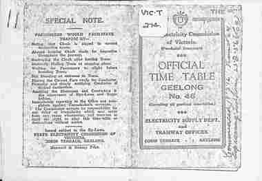
Ephemera - Photocopy, State Electricity Commission of Victoria (SECV), "Official Time Table Geelong No. 46", c1951
... Photocopy of the Geelong Timetable, No. 46, c1951 giving details of the fares, transfers, luggage or parcels, lost property, times of each tram on the Newtown, West Geelong, East Geelong, Chilwell, Eastern Park, Belmont and North lines. Note: Sheets may not be in the same order as the printed versions due to the photocopying method. ...Ballarat Tramway Museum South Gardens Reserve Wendouree Parade Ballarat Ballarat goldfields Photocopy of the Geelong Timetable, No. 46, c1951 giving details of the fares, transfers, luggage or parcels, lost property, times of each tram on the Newtown, West Geelong, East Geelong, Chilwell, Eastern Park, Belmont and North lines. Note: Sheets may not be in the same order as the printed versions due to the photocopying method. ...Photocopy of the Geelong Timetable, No. 46, c1951 giving details of the fares, transfers, luggage or parcels, lost property, times of each tram on the Newtown, West Geelong, East Geelong, Chilwell, Eastern Park, Belmont and North lines. Note: Sheets may not be in the same order as the printed versions due to the photocopying method. See items 5357 and 5629 and 8552 for other versions. Yields information about the operation of the Geelong tramway system.Photocopy - 17 A4 sheets of the "Official Time Table Geelong No. 46" on heat sensitive paper.tramways, trams, geelong, timetable, operations -
 Ballarat Tramway Museum
Ephemera - Set of 5 - Timetables - Geelong bus, Trans Otway, 1956
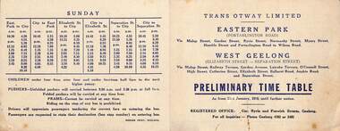
... Eastern Park and West Geelong dated 23/1/1956 - gives route and times. Printed - 111x142mm 2 - Benders Busways - Chillwell - gives times, fares, bus stop locations and route details - tri fold foolscap - 210 x 111 3 - ditto - for Newtown 4 - Corio bus lines - Belmont - City from 26/3/1956 - gives sections, fares, routes, times and route details - folded quarto - 205 x 164 - two copies 5 - Benders Busways - North Geelong, leaving from Maples store to Pilington's factory. ...Eastern Park and West Geelong dated 23/1/1956 - gives route and times. Printed - 111x142mm 2 - Benders Busways - Chillwell - gives times, fares, bus stop locations and route details - tri fold foolscap - 210 x 111 3 - ditto - for Newtown 4 - Corio bus lines - Belmont - City from 26/3/1956 - gives sections, fares, routes, times and route details - folded quarto - 205 x 164 - two copies 5 - Benders Busways - North Geelong, leaving from Maples store to Pilington's factory. printed on pink paper, 330 x 209. ...Set of 5 - Timetables - Geelong buses that were introduced following the closure of the Geelong tram system. 1 - Trans Otway - Eastern Park and West Geelong dated 23/1/1956 - gives route and times. Printed - 111x142mm 2 - Benders Busways - Chillwell - gives times, fares, bus stop locations and route details - tri fold foolscap - 210 x 111 3 - ditto - for Newtown 4 - Corio bus lines - Belmont - City from 26/3/1956 - gives sections, fares, routes, times and route details - folded quarto - 205 x 164 - two copies 5 - Benders Busways - North Geelong, leaving from Maples store to Pilington's factory. printed on pink paper, 330 x 209. All other than item 5, note that folded pushers carried at any times, unfolded between 9.30 and 3.30, no prams. See item 6812 for the Transport Regulation Board poster of 1956 and two other bus operators.Yields information about the bus timetables following the closure of the Geelong tram system.Set of five printed or duplicated documentstramways, geelong, closure, bus, buses, bus replacement, timeables, trans otway, corio bus lines, benders busways -
 Ballarat Tramway Museum
Document - Photocopy, State Electricity Commission of Victoria (SECV), "Official Time Table Geelong No. 47", March 1953
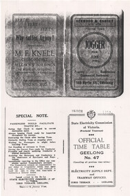
... Photocopy of the March 1953 SEC Geelong Timetable, giving details of the fares, transfers, luggage or parcels, lost property, times of each tram on the Newtown, West Geelong, East Geelong, Chilwell, Eastern Park, Belmont and North lines. Has adverts for M F Knell chiropodist, Henwood and Dancey Printers, photos of the Captain and Coach and Secretary of the Geelong Football Club, a list of Premiership records, goals and Brownlow Medals. ...Ballarat Tramway Museum South Gardens Reserve Wendouree Parade Ballarat Ballarat goldfields Photocopy of the March 1953 SEC Geelong Timetable, giving details of the fares, transfers, luggage or parcels, lost property, times of each tram on the Newtown, West Geelong, East Geelong, Chilwell, Eastern Park, Belmont and North lines. Has adverts for M F Knell chiropodist, Henwood and Dancey Printers, photos of the Captain and Coach and Secretary of the Geelong Football Club, a list of Premiership records, goals and Brownlow Medals. ...Photocopy of the March 1953 SEC Geelong Timetable, giving details of the fares, transfers, luggage or parcels, lost property, times of each tram on the Newtown, West Geelong, East Geelong, Chilwell, Eastern Park, Belmont and North lines. Has adverts for M F Knell chiropodist, Henwood and Dancey Printers, photos of the Captain and Coach and Secretary of the Geelong Football Club, a list of Premiership records, goals and Brownlow Medals. Note: Sheets are not in the same order as the printed versions due to the photocopying method. See items 5357 and 5629 and 9821 for other versions. Yields information about the operation of the Geelong tramway system.Photocopy - 17 A4 sheets of the "Official Time Table Geelong No. 47" published March 1953tramways, trams, geelong, football, timetable, operations -
 Ballarat Tramway Museum
Magazine, Australian Electric Traction Association (AETA), "The Trolley Wire", Vol 1, No. 3, "The Trolley Wire", Vol 1, No. 4, "The Trolley Wire", Vol 1, No. 7, "The Trolley Wire", Vol 1, No. 8, "The Trolley Wire", Vol 1, No. 10, 1952
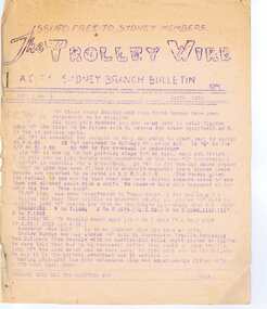
... Has notes on Association news, (left hand side very faded), map of the Enfield's lines, Brisbane Trolley Bus system 1952, Sydney news, and Eastern Suburbs roll. 5285.5 - Spirit duplicated magazine, 9 quarto pages, single sided - " The Trolley Wire", Vol 1, No. 10, November 1952, stapled down along the left hand side. ...Has notes on Association news, (left hand side very faded), map of the Enfield's lines, Brisbane Trolley Bus system 1952, Sydney news, and Eastern Suburbs roll. 5285.5 - Spirit duplicated magazine, 9 quarto pages, single sided - " The Trolley Wire", Vol 1, No. 10, November 1952, stapled down along the left hand side. ...5685.1 - Spirit duplicated magazine, 4 quarto pages, single sided - " The Trolley Wire", Vol 1, No. 3, April 1952, stapled down along the left hand side. Has items on Sydney trams, a Map of Ballarat tramways (See image i2), Newcastle News, and a discussion of the influx of transport experts into Sydney from England. 5685.2 - Spirit duplicated magazine, 7 quarto pages, single sided - " The Trolley Wire", Vol 1, No. 4, May 1952, stapled down along the left hand side. Has notes on use of tramway power for pumping stations, map of Bendigo (see image i4), news from Brisbane, Sydney news, association news, tramcar painting letters, Newcastle Destination roll 5685.3 - Spirit duplicated magazine, 7 quarto pages, single sided - " The Trolley Wire", Vol 1, No. 7, August 1952, stapled down along the left hand side. Has notes on Brisbane, Association news, map of the La Perouse - Botany - Mascot district, Ryde Cemetery, Sydney R 1890 runaway, North Sydney destination roll (1910) 5685.4 - Spirit duplicated magazine, 8 quarto pages, single sided - " The Trolley Wire", Vol 1, No. 8, September 1952, stapled down along the left hand side. Has notes on Association news, (left hand side very faded), map of the Enfield's lines, Brisbane Trolley Bus system 1952, Sydney news, and Eastern Suburbs roll. 5285.5 - Spirit duplicated magazine, 9 quarto pages, single sided - " The Trolley Wire", Vol 1, No. 10, November 1952, stapled down along the left hand side. Has notes on Brisbane, Wylde St trolley bus route in Sydney, Sydney news, association notes, Proposed lines in Sydney - Haberfield to Dobroyd, use of triple trams in Sydney, Broken Hill destination roll, Fort Macquarie depot track drawing and Newcastle news. See Reg Item 5685 for other Vol 1 issues and Reg Item 5686 for Vol. 2 issues.Vol 1, No. 4 has pencil inscription of "H. H. Matthews" in top right hand corner.trams, tramways, tramway news, history, sydney, newcastle, broken hill, brisbane, ballarat, bendigo, map -
 Wodonga & District Historical Society Inc
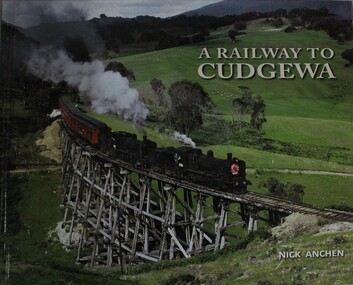
Book - A Railway to Cudgewa, Nick Anchen, 2013
... Wodonga & District Historical Society Inc Hut 97, Bonegilla Migrant Experience, 132 Bonegilla Road Bonegilla the-murray railroads victoria railways cudgewa railways wodonga railways high country The spectacular mountain railway from Wodonga to Cudgewa in north eastern Victoria was one of Australia's truly fascinating branch lines, and the most challenging to operate on the Victorian Railways. ...The spectacular mountain railway from Wodonga to Cudgewa in north eastern Victoria was one of Australia's truly fascinating branch lines, and the most challenging to operate on the Victorian Railways. It was a railway of scenic splendour, famous for its towering wooden bridges, notoriously steep grades, Hereford cattle and K class steam locomotives. This lavishly illustrated publication includes over 100 colour and B&W photographs, and tells the story of the railway through the memories of Cudgewa railway enginemen, station masters, bridge gangers,non-fictionThe spectacular mountain railway from Wodonga to Cudgewa in north eastern Victoria was one of Australia's truly fascinating branch lines, and the most challenging to operate on the Victorian Railways. It was a railway of scenic splendour, famous for its towering wooden bridges, notoriously steep grades, Hereford cattle and K class steam locomotives. This lavishly illustrated publication includes over 100 colour and B&W photographs, and tells the story of the railway through the memories of Cudgewa railway enginemen, station masters, bridge gangers,railroads victoria, railways cudgewa, railways wodonga, railways high country -
 Nillumbik Shire Council
Drawing: Tim RYAN, Tim Ryan, Queenscliff 1,2 and 3, 2012
... eastern suburbs of Melbourne (Nillumbik region), that provides accommodation and day services for adults with an intellectual disability / Creating and sharing artwork is one way Araluen participants express their thoughts, personalities and abilities. The art program allows them to develop a sense of achievement and access society as equal and valued participants / Tim puts a great deal of effort into selecting his subject and arranging his page / He immerses himself in the image, studying it thoroughly and sometimes tracing over it with his finger before commencing / He focuses on the different elements and relationships that inspire, bringing out the lines, colours and shapes most fitted for translation into the picture / Favourite references are photo-laden books and magazines covering topics as broad as nature, history, archaeology, exotic foreign lands and all forms of transport. drawings / black & white / ink / boats / ships / queenscliff / araluen / ryan / disability None shown, catalogue label on back Three black and white drawings of boats/ships in Queenscliff made using watercolor, ink, fine liner, pencil and acrylic on paper. ...“Queenscliff (three black and white boat/ship themed set), is a depiction of a trio of sailing vessels, and a typical example of Tim Ryan’s process and style / It illustrates three images from separate editions of National Geographic – a much-loved and constantly revisited source of inspiration / Tim has reduced his subject matter to minimal line, managing to capture the form and character of the scene and the people within with delicacy and sensitivity / As is also a common trait, Tim has discarded the idea of a using a title describing the actual scenes in favour of one that holds much greater personal significance / Queenscliff is the site of his family holiday home, hence a place evoking decades of memories connected with water, horizon and water-based activity and interaction.Tim Ryan has worked within the Studio Art Program at Araluen for almost a decade / Araluen is based in the north eastern suburbs of Melbourne (Nillumbik region), that provides accommodation and day services for adults with an intellectual disability / Creating and sharing artwork is one way Araluen participants express their thoughts, personalities and abilities. The art program allows them to develop a sense of achievement and access society as equal and valued participants / Tim puts a great deal of effort into selecting his subject and arranging his page / He immerses himself in the image, studying it thoroughly and sometimes tracing over it with his finger before commencing / He focuses on the different elements and relationships that inspire, bringing out the lines, colours and shapes most fitted for translation into the picture / Favourite references are photo-laden books and magazines covering topics as broad as nature, history, archaeology, exotic foreign lands and all forms of transport.Three black and white drawings of boats/ships in Queenscliff made using watercolor, ink, fine liner, pencil and acrylic on paper. All drawings are black and white in colour with one drawing rendering a boat in warm red/orange and yellow colours. None shown, catalogue label on backdrawings / black & white / ink / boats / ships / queenscliff / araluen / ryan / disability -
 Whitehorse Historical Society Inc.
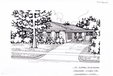
Artwork, other - Ink Line Drawing, 10 Alfred St., Burwood, 1999
... lines are believed to have been redrawn, making this property no longer in Burwood, but located in Glen iris. This property is listed as having sold for in 1999 for $380,000 Trained as a cartographic draftsman within the mining industry, Margaret Picken is an artist who worked producing property illustrations for real estate agencies in eastern suburbs of Victoria from 1983-2005. ...lines are believed to have been redrawn, making this property no longer in Burwood, but located in Glen iris. This property is listed as having sold for in 1999 for $380,000 Trained as a cartographic draftsman within the mining industry, Margaret Picken is an artist who worked producing property illustrations for real estate agencies in eastern suburbs of Victoria from 1983-2005. ...A property illustration by Margaret Picken Commissioned by the real estate agency Woodards, Camberwell for the purpose of advertising 10 Alfred St., Burwood for sale in 1999. Made by using Rotring ‘Rapidigraph’ drafting pens with Rotring ink on Rapidigraph polyester drafting film, double matte. The suburb lines are believed to have been redrawn, making this property no longer in Burwood, but located in Glen iris. This property is listed as having sold for in 1999 for $380,000 Trained as a cartographic draftsman within the mining industry, Margaret Picken is an artist who worked producing property illustrations for real estate agencies in eastern suburbs of Victoria from 1983-2005. Retiring from the industry as technological changes favoured coloured photography over illustrations, and commissioning companies over sole contractors.This artwork is of Historical Significance as a record of local domestic architecture.A Black ink line drawing on drafters film by Maragret Picken, of 10 Alfred St., Burwood. Depicted is a one-story brick house situated back from a front lawn with a large tree, and a driveway on the right, leading to a connected carport. There to two hole punches just below the upper edge, and a approximately 1cmx1cm tape reside mark left of centre near the bottom edge 10 Alfred St., Burwood Maragret Picken - 99 Woodards - c'wellwhitehorse historical society, schwerkolt cottage, housing, architecture, margaret picken, burwood, glen iris, house, garden -
 Whitehorse Historical Society Inc.
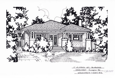
Artwork, other - Ink Line Drawing, 11 Alfred St., Burwood, 1999
... lines are believed to have been redrawn, making this property no longer in Burwood, but located in Glen iris. This property is listed as having sold for in 1990, Trained as a cartographic draftsman within the mining industry, Margaret Picken is an artist who worked producing property illustrations for real estate agencies in eastern suburbs of Victoria from 1983-2005. ...lines are believed to have been redrawn, making this property no longer in Burwood, but located in Glen iris. This property is listed as having sold for in 1990, Trained as a cartographic draftsman within the mining industry, Margaret Picken is an artist who worked producing property illustrations for real estate agencies in eastern suburbs of Victoria from 1983-2005. ...A property illustration by Margaret Picken Commissioned by the real estate agency Woodards, Camberwell for the purpose of advertising 11 Alfred St., Burwood for sale in 1990. Made by using Rotring ‘Rapidigraph’ drafting pens with Rotring ink on Rapidigraph polyester drafting film, double matte. The suburb lines are believed to have been redrawn, making this property no longer in Burwood, but located in Glen iris. This property is listed as having sold for in 1990, Trained as a cartographic draftsman within the mining industry, Margaret Picken is an artist who worked producing property illustrations for real estate agencies in eastern suburbs of Victoria from 1983-2005. Retiring from the industry as technological changes favoured coloured photography over illustrations, and commissioning companies over sole contractors.This artwork is of Historical Significance as a record of local domestic architecture.A black ink line drawing on drafters film by Maragret Picken, of 11 Alfred St., Burwood. Depicted is a one-story weatherboard situated back from a front lawn with a large tree, and a brick driveway on the left. Bushes are planted in front of the porch, and greenery on the left and right of the image. There to two hole punches just below the upper edge. 11 Alfred St., Burwood Maragret Picken -'99 Woodards - Glen Iriswhitehorse historical society, schwerkolt cottage, housing, architecture, margaret picken, burwood, glen iris, house, garden -
 Whitehorse Historical Society Inc.
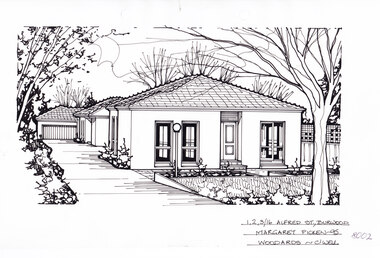
Artwork, other - Ink Line Drawing, 1,2,3/16 Alfred St., Burwood, 1995
... The suburb lines are believed to have been redrawn, making this property no longer in Burwood, but located in Glen iris. 1/16 Alfred St., Burwood is listed as having sold for in 1995 for $185,000 Trained as a cartographic draftsman within the mining industry, Margaret Picken is an artist who worked producing property illustrations for real estate agencies in eastern suburbs of Victoria from 1983-2005. ...The suburb lines are believed to have been redrawn, making this property no longer in Burwood, but located in Glen iris. 1/16 Alfred St., Burwood is listed as having sold for in 1995 for $185,000 Trained as a cartographic draftsman within the mining industry, Margaret Picken is an artist who worked producing property illustrations for real estate agencies in eastern suburbs of Victoria from 1983-2005. ...A property illustration by Margaret Picken Commissioned by the real estate agency Woodards, Camberwell for the purpose of advertising 1,2,3/16 Alfred St., Burwood for sale in 1995. Made by using Rotring ‘Rapidigraph’ drafting pens with Rotring ink on Rapidigraph polyester drafting film, double matte. The suburb lines are believed to have been redrawn, making this property no longer in Burwood, but located in Glen iris. 1/16 Alfred St., Burwood is listed as having sold for in 1995 for $185,000 Trained as a cartographic draftsman within the mining industry, Margaret Picken is an artist who worked producing property illustrations for real estate agencies in eastern suburbs of Victoria from 1983-2005. Retiring from the industry as technological changes favoured coloured photography over illustrations, and commissioning companies over sole contractors.This artwork is of Historical Significance as a record of local domestic architecture.A black ink line drawing on drafters film by Maragret Picken, of 1,2,3/16 Alfred St., Burwood. Depicted are three one-story rendered houses on one block, one behind the other, situated back from a front lawn with a large tree on the right, and a driveway on the left leading to a garage There to two hole punches just below the upper edge An approximately 1.5cmx0.5 tape reside mark at the centre of the bottom edge A 1cm vertical line of dirty tape residue on the center of the upper edge. 1,2,3/16 Alfred St., Burwood Margaret Picken - 95 Woodards - c'wellwhitehorse historical society, schwerkolt cottage, housing, architecture, margaret picken, burwood, glen iris, house, garden -
 Whitehorse Historical Society Inc.
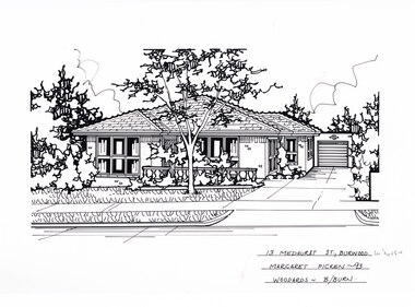
Artwork, other - Ink Line Drawing, Margaret Picken, 13 Medhurst St., Burwood, 1993
... lines are believed to have been redrawn, making this property no longer in Burwood, but located in Burwood East. This property which was built in circa 1960's, is listed as having sold for $130,000 in 1993 Trained as a cartographic draftsman within the mining industry, Margaret Picken is an artist who worked producing property illustrations for real estate agencies in eastern suburbs of Victoria from 1983-2005. ...lines are believed to have been redrawn, making this property no longer in Burwood, but located in Burwood East. This property which was built in circa 1960's, is listed as having sold for $130,000 in 1993 Trained as a cartographic draftsman within the mining industry, Margaret Picken is an artist who worked producing property illustrations for real estate agencies in eastern suburbs of Victoria from 1983-2005. ...A property illustration by Margaret Picken Commissioned by the real estate agency Woodards Blackburn for the purpose of advertising 13 Medhurst St., Burwood in 1993 Made by using Rotring ‘Rapidigraph’ drafting pens with Rotring ink on Rapidigraph polyester drafting film, double matte. The suburb lines are believed to have been redrawn, making this property no longer in Burwood, but located in Burwood East. This property which was built in circa 1960's, is listed as having sold for $130,000 in 1993 Trained as a cartographic draftsman within the mining industry, Margaret Picken is an artist who worked producing property illustrations for real estate agencies in eastern suburbs of Victoria from 1983-2005. Retiring from the industry as technological changes favored coloured photography over illustrations, and commissioning companies over sole contractors.This artwork is of Historical Significance as a record of local domestic architecture.A black ink line drawing on drafters film by Margaret Picken, of 13 Medhurst St., Burwood. Of a one story brick house with driveway to the left leading to a garage. In the foreground is a front lawn with a gumtree. There is a thin reddish 2.5cm mark to the left of the inscription.13 Medhurst St., Burwood Margaret Picken -93 Woodards - B/Burnwhitehorse historical society, schwerkolt cottage, housing, architecture, margaret picken, burwood, house, garden, burwood east -
 Whitehorse Historical Society Inc.
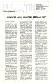
Document, Eastern Corridor Study, 9/10/1975
... Bulletin, Eastern Corridor Study (Combining Koonung and Ringwood Studies) issued by the study consultants, Alan M. Voorhees & Partners P/L, Bulletin No 3, 9 October 1975: Routes 'A', 'B' and 'E' - Ringwood Sector, Lines of minimum impact....Voorhees & Partners P/L Roads and Streets Freeways Ringwood Mitcham Bulletin, Eastern Corridor Study (Combining Koonung and Ringwood Studies) issued by the study consultants, Alan M. Voorhees & Partners P/L, Bulletin No 3, 9 October 1975: Routes 'A', 'B' and 'E' - Ringwood Sector, Lines of minimum impact. ...Bulletin, Eastern Corridor Study (Combining Koonung and Ringwood Studies) issued by the study consultants, Alan M. Voorhees & Partners P/L, Bulletin No 3, 9 October 1975: Routes 'A', 'B' and 'E' - Ringwood Sector, Lines of minimum impact.eastern freeway, alan m. voorhees & partners p/l, roads and streets, freeways, ringwood, mitcham -
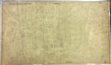 Kew Historical Society Inc
Map, MMBW, MMBW Plan No.66 Kew, 1900-1910
... The map covers what was then the south eastern part of Kew, bordered on its north by Adeney Avenue, in the west by Sackville Street, in the south by Barkers Road, and in the east by Burke Road. The map shows the extent of urban development by that time, prominent institutions and the outlines of built structures in the municipality. Contour lines...The map covers what was then the south eastern part of Kew, bordered on its north by Adeney Avenue, in the west by Sackville Street, in the south by Barkers Road, and in the east by Burke Road. The map shows the extent of urban development by that time, prominent institutions and the outlines of built structures in the municipality. Contour lines ...The Melbourne and Metropolitan Board of Works (MMBW) was established by an act of the Victorian Parliament in 1890 to prepare for and to implement a sewerage and water reticulation system across what was then inner Melbourne, its surrounding and middle distance suburbs, including Kew. The MMBW was disbanded in 1991.The map collection of the Kew Historical Society has at its core the historic maps assembled and originally stored in the City Engineer's Department of the City of Kew. These include maps in a number of scales. The vast majority of maps were produced by the MMBW in the first two decades of the twentieth century, and are solid working maps, backed by linen for durability. These maps are historically significant to Kew, the City of Boroondara and to the history of the development of state utilities in Victoria. A number of the Kew maps have additional details added by former municipal officers, including the levels reached by various floods. As these were working documents, information was added to them long after the period of their initial production and distribution.Early map of part of the Borough of Kew, created in the first decade of the twentieth century, at a scale 160 ft to 1 inch. The map covers what was then the south eastern part of Kew, bordered on its north by Adeney Avenue, in the west by Sackville Street, in the south by Barkers Road, and in the east by Burke Road. The map shows the extent of urban development by that time, prominent institutions and the outlines of built structures in the municipality. Contour lines were added in ink to the map at a later stage.MELBOURNE AND METROPOLITAN BOARD OF WORKS / PLAN NO. 66 / KEW melbourne & metropolitan board of works, mmbw maps, mmbw plans, borough of kew, cartography