Showing 77 items matching " elm road"
-
 Bayside Gallery - Bayside City Council Art & Heritage Collection
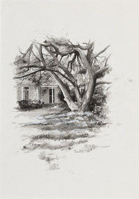
Work on paper - ink and watercolour, Annette Meikle, Chinese Elm - Corner Beach Road and Hampton Street, 1977
... Chinese Elm - Corner Beach Road and Hampton Street...It is recognised in the Significant Tree Register of Bayside City Council. annette meikle sandringham sketchbook elizabeth waters Chinese Elm Esmeralda Alfred William Harston Significant Tree Historic house Hampton Hampton Street Chinese Elm - Corner Beach Road and Hampton Street Work on paper ink and watercolour Annette Meikle ...In 1977, artist Annette Meikle undertook a commission to illustrate a book recording stories of places and people in the Bayside area. It was published in 1978 as Sandringham Sketchbook, with text by Elizabeth Waters. The sketches were intended to record remaining examples of Bayside’s early architecture and environment, as well as reflect newer architectural changes. Meikle went on to donate 22 of these sketches to Bayside City Council in 2003. The Chinese Elm tree illustrated here marks the site of ‘Esmeralda’ which stood at at 312-314 Hampton Street, Hampton. It was a rambling house built in 1872 by Alfred William Harston and demolished in the 1970s. The elm is thought to be over 150 years old and was preserved by Council when flats were built on the site. It is recognised in the Significant Tree Register of Bayside City Council.Annette Meikle, Chinese Elm - Corner Beach Road and Hampton Street 1977, ink and watercolour, 33.8 x 23.7 cm. Bayside City Council Art and Heritage Collection. Donated by the artist, 2003annette meikle, sandringham sketchbook, elizabeth waters, chinese elm, esmeralda, alfred william harston, significant tree, historic house, hampton, hampton street -
 Glen Eira Historical Society
Article - ‘REPTON’, ELM AVENUE, 10, ELSTERNWICK
... ... Elm Road...Repton Wahgunyah Elm Avenue Elm Road Elsternwick Roan Andrew Partridge John Douglas Partridge Alice Anna Partridge John Roland Phelps Phillips Ida Mary Charlotte Steers Reuben Rivers Mann Agnes Gruer William Frank Taylor James Alexander Marmaras George Marmaras Arthur Supported housing Stevens Edward Matthews Herbert Repton Court flats Marmara Drive Lehte Fosbery Avenue Taylor Florence Ethel Wood John Frances Wealth Brick houses Land subdivision Flats Victorian style Stubbs family Ryan Dermot Du Moulin Ryan Kate Elm Street House names Ryan H H Article ‘REPTON’, ELM AVENUE, 10, ELSTERNWICK ...This file contains six items about this mansion: 1/Three pages of handwritten notes by Peta Darke, dated December 2013, concerning the title and ownership of Repton from 1881 till 2013, earlier called ‘Wahgunyah’ 2/Handwritten list of owners of Repton from various editions of Sands and McDougall Directories compiled by Peta Darke on 06/12/2013 3/Black-and-white photograph of exterior of Repton, undated, photographer unknown 4/Seven copies each of a classified advertisement in The Argus newspaper relating to Repton and its occupiers. Dates are 15/01/1927, 15/12/1928, 07/03/1917, 10/07/1926, 02/07/1940, 10/04/1944, and 28/01/1949 5/Article in Property Review Weekly dated 15/11/2013 advertising forthcoming auction on 30/11/2013. Includes colour photographs of exterior and interior. Also brochure real estate agent advertising forthcoming auction of Repton: includes 4 colour photographs of exterior and interior, description of property and plan of layout. Produced in 2013. 6/Printed information taken from 'Trove' regarding former residents of 'Repton', Elm Street, Elsternwick by Claire Barton. Research is from the Stubss family tree about Dermot Du Moulin Ryan whose mother's address is listed as this property.repton, wahgunyah, elm avenue, elm road, elsternwick, roan andrew, partridge john douglas, partridge alice anna, partridge john roland phelps, phillips ida mary charlotte, steers reuben rivers, mann agnes, gruer william frank, taylor james alexander, marmaras george, marmaras arthur, supported housing, stevens edward, matthews herbert, repton court flats, marmara drive, lehte, fosbery avenue, taylor florence ethel, wood john frances wealth, brick houses, land subdivision, flats, victorian style, stubbs family, ryan dermot du moulin, ryan kate, elm street, house names, ryan h h -
 Surrey Hills Historical Society Collection
Folder of real estate advertisements, Folders of real estate advertisements (Streets beginning with E), Various
... ...elgar road...elm...Surrey Hills Historical Society Collection 190A Canterbury Road Canterbury melbourne earle close edyvean street elgar road elm street empress road erasmus street essex road everton grove A4 folders with individual pockets for each property in streets beginning with E located in Surrey Hills and Mont Albert. ...A4 folders with individual pockets for each property in streets beginning with E located in Surrey Hills and Mont Albert. Folders are ordered by street name and then chronologically by property number. Each property has its own pocket. This may include multiple real estate advertisements collected from sales over time. It may also include copies of any research undertaken by Alan Holt and / or members of the SHNCHC team. These are augmented by cards in the Alan Holt index file and by his property registers of Surrey Hills and Mont Albert.earle close, edyvean street, elgar road, elm street, empress road, erasmus street, essex road, everton grove -
Whitehorse Historical Society Inc.
Newspaper - Article, Pioneer home, n.d
... Elm Grove...Britnell's Road...[Photograph] taken in 1886 of 'Elm Grove' occupied by John and Mary Ann Talbett and family, in Britnell's, now Middleborough Road. ...Whitehorse Historical Society Inc. 2-10 Deep Creek Road Mitcham melbourne Wattle and Daub Talbett John Talbett Mary Ann Elm Grove Britnell's Road Middleborough Road [Photograph] taken in 1886 of 'Elm Grove' occupied by John and Mary Ann Talbett and family, in Britnell's, now Middleborough Road. ...[Photograph] taken in 1886 of 'Elm Grove' occupied by John and Mary Ann Talbett and family, in Britnell's, now Middleborough Road. [Newspaper cutting].wattle and daub, talbett, john, talbett, mary ann, elm grove, britnell's road, middleborough road -
 Geelong Cycling Club
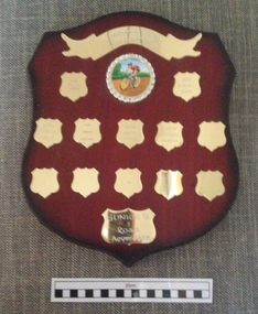
Shield, 2001
... "Geelong West Cycling Club/2001/Jacob Smith/2002/Mitchell Elmer/2003/Chesney Milne/2004/Jordan Vericondi/2005/Bradley Young/2006/Mitchell Elmer/Junior B/Road Aggregate"...Road Races were a feature of Geelong Cycling Club during the years 2001-2006. Indicates the boom time experienced for Junior Cyclists at the Geelong Cycling Club during the years 2001-2006 geelong west cycling club; jacob smith; mitchell elmer; chesney milne; jordan vericondi; bradley young; junior b; road aggregate; "Geelong West Cycling Club/2001/Jacob Smith/2002/Mitchell Elmer/2003/Chesney Milne/2004/Jordan Vericondi/2005/Bradley Young/2006/Mitchell Elmer/Junior B/Road Aggregate" A mahogany coloured wooden shield with gold plated plaques containing inscriptions of winners of the Junior B Road Aggregate during the years 2001-2006. ...Junior A & B grades in Road Races were a feature of Geelong Cycling Club during the years 2001-2006.Indicates the boom time experienced for Junior Cyclists at the Geelong Cycling Club during the years 2001-2006A mahogany coloured wooden shield with gold plated plaques containing inscriptions of winners of the Junior B Road Aggregate during the years 2001-2006. There is an emblem of a cyclist and a banner at the top centre of the shield. "Geelong West Cycling Club/2001/Jacob Smith/2002/Mitchell Elmer/2003/Chesney Milne/2004/Jordan Vericondi/2005/Bradley Young/2006/Mitchell Elmer/Junior B/Road Aggregate"geelong west cycling club; jacob smith; mitchell elmer; chesney milne; jordan vericondi; bradley young; junior b; road aggregate; -
Kew Historical Society Inc
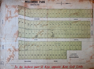
Plan - Willsmere Park Estate, Kew, 1926
... Streets within the subdivision included: Willow Grove, Kilby Road, Elm Grove and Belford Road. The double page spread on pages 2 and 3 shows the detailed plan of the 40 lots, surrounded by public parkland [Willsmere Park] and the Kew Golf Links. ...Streets within the subdivision included: Willow Grove, Kilby Road, Elm Grove and Belford Road. The double page spread on pages 2 and 3 shows the detailed plan of the 40 lots, surrounded by public parkland [Willsmere Park] and the Kew Golf Links. ...Subdivision plans and real estate flyers/brochures reveal a number of aspects of urban development and history. The Kew Historical Society's collection of these plans, as well as advertisements extracted from magazines, cover key aspects of community development and architectural history of Kew and Kew Eat as well as surrounding suburbs. While most of the plans in the collection were gifted to the Society by the former City of Kew, a number of other plans and advertisements have been donated by individuals, of which this is an example.Original 4-page, bifold subdivision plan of the Willsmere Park Estate, Kew. The 1926 land sale advertised '40 superb villa allotments' on the 'Yarra Heights'. Streets within the subdivision included: Willow Grove, Kilby Road, Elm Grove and Belford Road. The double page spread on pages 2 and 3 shows the detailed plan of the 40 lots, surrounded by public parkland [Willsmere Park] and the Kew Golf Links. By the time that this version of the plan was released, only the lots on Willow Grove and Kilby Road remained. willsmere park estate -- kew (vic.), subdivisions - kew (vic.), subdivisions -- kew east (vic.), willsmere park -- kew east (vic.) -
 Kew Historical Society Inc
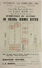
Plan - Subdivision Plan, Subdivision by Auction: 16 Ideal Home Sites, East Kew, 1940, 1940
... Streets named in the plan include: Kilby Road, Belford Road, Elm Grove, Willow Grove. Willsmere Park is indicated but not named. ...Streets named in the plan include: Kilby Road, Belford Road, Elm Grove, Willow Grove. Willsmere Park is indicated but not named. ...An advertisement for the sale of a subdivision by Auction: of 16 Ideal Home Sites, East Kew, 1940. This significant sale of land between the Kew Golf Course and Willsmere Park led to the streets having a high degree of architectural uniformity.The subdivision in the second year of the war indicates that land sales for homes and speculation continued from the 1930s into the period of the Second World War. There is no indication on the plan that a war is occurring.Single page subdivision plan advertising the sale by Auction of 16 Ideal Home Sites, in East Kew, on 17 February 1940. Streets named in the plan include: Kilby Road, Belford Road, Elm Grove, Willow Grove. Willsmere Park is indicated but not named. The auction was conducted by Beauchamp Brothers. A number of lots are coloured pink on the plan indicating those lots for sale and/or those already sold.subdivision plans - kew east (vic) -
 Whitehorse Historical Society Inc.
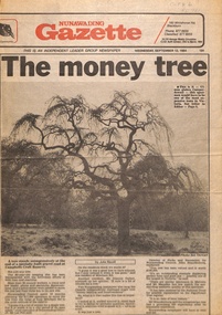
Newspaper - Article, The Money Tree, 12/09/1984
... The article describes the decision to move an 80 year old weeping elm tree from Mitcham Road to Campbell's Croft Reserve. ...Whitehorse Historical Society Inc. 2-10 Deep Creek Road Mitcham melbourne fell les trees campbells croft city of nunawading brandenburg john p The article describes the decision to move an 80 year old weeping elm tree from Mitcham Road to Campbell's Croft Reserve. ...The article describes the decision to move an 80 year old weeping elm tree from Mitcham Road to Campbell's Croft Reserve. The removalist cost of $17,000 raised some objections from local residents. The tree was valued at $100,000 in 1984, described as an outstanding example displaying perfect form and a good size - one of the largest in Victoria.fell, les, trees, campbells croft, city of nunawading, brandenburg, john p -
 Kew Historical Society Inc
Plan - Subdivision Plan, J R Mathers & McMillan, Willsmere Park Estate, c.1940
... The first subdivision of the Estate included 77 grand allotments with frontages to Belford and Kilby Roads, Elm and Willow Groves, and Acacia Avenue. ...The first subdivision of the Estate included 77 grand allotments with frontages to Belford and Kilby Roads, Elm and Willow Groves, and Acacia Avenue. ...Pru Sanderson, in her groundbreaking ‘City of Kew Urban Conservation Study : Volume 2 - Development History’ (1988), summarised the periods of urban development and subdivisions of land in Kew. The periods that she identified included 1845-1880, 1880-1893, 1893-1921, 1921-1933, 1933-1943, and Post-War Development. These periods were selected as they represented periods of rapid growth or decline in urban development. An obvious starting point for Sanderson’s groupings involved population growth and the associated economic cycles. These cycles also highlighted urban expansion onto land that was predominantly rural, although in other cases it represented the decline and breakup of large estates. A number of the plans in the Kew Historical Society’s collection can also be found in other collections, such as those of the State Library of Victoria and the Boroondara Library Service. A number are however unique to the collection.The Kew Historical Society collection includes almost 100 subdivision plans pertaining to suburbs of the City of Melbourne. Most of these are of Kew, Kew East or Studley Park, although a smaller number are plans of Camberwell, Deepdene, Balwyn and Hawthorn. It is believed that the majority of the plans were gifted to the Society by persons connected with the real estate firm - J. R. Mathers and McMillan, 136 Cotham Road, Kew. The Plans in the collection are rarely in pristine form, being working plans on which the agent would write notes and record lots sold and the prices of these. The subdivision plans are historically significant examples of the growth of urban Melbourne from the beginning of the 20th Century up until the 1980s. A number of the plans are double-sided and often include a photograph on the reverse. A number of the latter are by noted photographers such as J.E. Barnes. In 1910, the Willsmere Park Estate Dairy was lauded in the Box Hill Reporter as ‘an object lesson in dairying’. Ten years later, in 1923, it was to be sold. The first subdivision of the Estate included 77 grand allotments with frontages to Belford and Kilby Roads, Elm and Willow Groves, and Acacia Avenue. Every lot was claimed to be ‘high and dry’, and with panoramic views of Kew and East Kew. The balance of the Estate, and the largest proportion of allotments was to be subdivided and sold from 1940. This second sale included 109 lots fronting Kilby Road and Elm and Willow Groves. Annotations on the plan indicate that the more expensive lots faced Belford Road opposite the Kew Golf Links. Two of these sold for £310. Lots further to the west in Willow Grove were sold for £60 less. Many of the houses to be built on these 109 allotments after the War faced Government restrictions on building materials and the dimensions of each house due to postwar shortages.subdivision plans - east kew, willsmere park estate -
 Mt Dandenong & District Historical Society Inc.
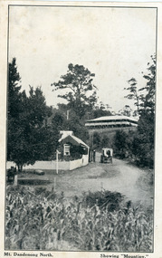
Photograph, Mt Dandenong North. Showing "Mountjoy"
... Old Coach Road comes into the picture from the right and the horse and cart is heading up Ridge Road. The elm trees can be seen on the left. The building up on the hill is the Mountjoy Guest House. ...Old Coach Road comes into the picture from the right and the horse and cart is heading up Ridge Road. The elm trees can be seen on the left. The building up on the hill is the Mountjoy Guest House. ...The building with the white picket fence is the Beulah Tea Gardens opened by Eliza Hand c1904 at The Gap (now FiveWays). The building is still operating as a cafe. The Tourist Road does not yet exist. Old Coach Road comes into the picture from the right and the horse and cart is heading up Ridge Road. The elm trees can be seen on the left. The building up on the hill is the Mountjoy Guest House. ‘Mountjoy’ was built by the Paynter family in 1905. It had fourteen bedrooms, a dining room and sitting room, kitchen with a big wood burning range and verandahs on three sides. There were commanding views of the eastern ranges and the city to the west. Ellis Jeeves purchased ‘Mountjoy’ in 1908 and it soon became a popular tourist destination, the coach yards making it a centre of the district. ‘Mountjoy’ is a central feature of many photographs of Kalorama in the 1900s. The building burned down in 1975. Mt. Dandenong North was renamed Kalorama in 1926.Black and white postcard showing a horse and cart on road between two buildings.On front ; Mt. Dandenong North. Showing "Mountjoy."postcard, mountjoy, guest house, beulah tea room, beulah, mt dandenong north, kalorama -
 Wodonga & District Historical Society Inc
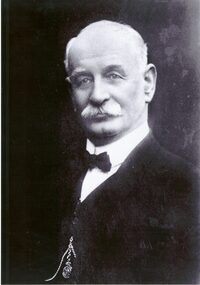
Photograph - Henry Beardmore - Wodonga Shire Councillor and Member for Benambra
... His last residence was on the corner Elm Street and Beechworth Road....His last residence was on the corner Elm Street and Beechworth Road. This photo is significant because it depicts an important local and State politician and member of the Wodonga Community. ...Henry Beardmore was a significant contributor to Wodonga and the state of Victoria. He was born in Melton on 7th February 1863 to Edwin James Beardmore and Flora McDonald. He grew up in Benalla and became a butcher at Glenrowan before taking up land at Leneva near Wodonga, Victoria. On 15 July 1885 Henry married his first wife, Agnes Annie Lee and they had two sons and two daughters. Agnes died in 1892. In 23 August 1893, Henry married Jessie Muirhead and they had six sons and four daughters. Henry represented the Green Hills riding on Wodonga Shire Council from 1898 to 1922, including terms as President from 1900-01, 1903-4, 1908-10, 1911-12, 1914-17. In 1922 Mr. Beardmore retired from the Wodonga Council due to his increased workload in State politics. Henry Beardmore was a Freemason including Master of the Wodonga Lodge from 1906 to 1907, and was an active member up until his death. From 1905-1915, Henry Beardmore leased “De Kerilleau” homestead with the exception of 1907, when Mr W. Huon was in residence, and after he died there in 1907, the Beardmore family returned. Henry Beardmore won the seat of Benambra in the Victorian Legislative Assembly at a by-election on 20th April 1917. He continuously represented the Benambra electorate as a Nationalist and United Australia Party member for more than 15 years. He was a strong advocate for country development and decentralisation, but he declined to join the Country Party. He held the seat of Benambra, up to the date of his death, and was returned unopposed on four occasions. He was an Honorary Minister in 1924 and for a short time in 1929, Minister of Railways, Minister in-charge of Electrical Undertakings and Minister of Labour. He was a leading supporter of Kiewa Hydro-Electric Project and opponent of Yallourn coalfield. Henry Beardmore died in Wodonga on 29 August 1932. His last residence was on the corner Elm Street and Beechworth Road.This photo is significant because it depicts an important local and State politician and member of the Wodonga Community.A black and white formal portrait of Henry Beardmore.henry beardmore, wodonga council, benambra - victorian politics -
 Warrnambool and District Historical Society Inc.
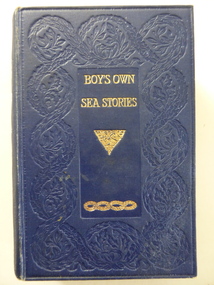
Book, Boy's own sea stories, Early 20th century
... Warrnambool and District Historical Society Inc. 2 Gilles Street (south of Merri St) Warrnambool great-ocean-road This book of sea stories belonged to C. Simpson of ‘Elm Bank’, Wangoom. ...This book of sea stories belonged to C. Simpson of ‘Elm Bank’, Wangoom. Charles Simpson was a farmer at Wangoom in the 1860s. The township of Wangoom is about ten kilometres from Warrnambool. Charles Simpson was the brother of George Simpson of Nullawarre and William Simpson who had a drapery store in Warrnambool. The owner of the book would be a descendant of one of these early settlers. This book is of interest as it belonged to a member of the Simpson families, several of whom were early settlers in the Warrnambool district. This is a hard cover book of 424 pages. The cover is dark blue with gold lettering and gold scroll work. The book has a preface, 42 chapters of sea stories and, at the back of the book, several pages of advertisements for other books published by Ward, Lock and Co. There are many black and white sketches scattered throughout the text. The inscriptions are handwritten in black ink. ‘C. Simpson, Elm Bank, Wangoom’ (3 entries) simpson families of 19th century, warrnambool and district -
Glen Eira Historical Society
Document - Hotels, Caulfield
... Road The Tam O’Shanter Hotel Wilston Street Farmers’ Arms Home Hotel Chestnut Street Hooper Street Thompson William Martin P. J. Orme Frederick Orme Fred Nicholls William Henry Mullins John Armstrong John Egan James Westwood James Westwood Ellen Greenberg David Greenberg Sydney Greenberg Rose Spamm Cath Pitter Mabel Morrow Andrew Morrow Andy Feddan George Curtis Guess John Evans Rowland Evans Roland Riordan John Smith George Elms Bedwell C. ...This file contains one item: 1/Handwritten research notes recording details about various hotels in the Caulfield area and environs. Details include handwritten maps and lists of publicans/licensees/nominees. Notes by author unknown and undated. Some of the notes make reference to entries in Sands & McDougall directories.r. k. cole hotel collection, london tavern hotel, london tavern and store, glen huntly road, caulfield, sycamore street, hawthorn road, dandenong road, derby road, koornang road, caulfield club hotel, rosstown hotel, royal hotel, the vine beer house, the vine caulfield hotel, newton h., balaclava road, bambra road, mirrambeena road, murrumbeena road, poath road, the tam o’shanter hotel, wilston street, farmers’ arms home hotel, chestnut street, hooper street, thompson william, martin p. j., orme frederick, orme fred, nicholls william henry, mullins john, armstrong john, egan james, westwood james, westwood ellen, greenberg david, greenberg sydney, greenberg rose, spamm cath, pitter mabel, morrow andrew, morrow andy, feddan george curtis, guess john, evans rowland, evans roland, riordan john, smith george elms, bedwell c., griffen frederick, connelly p. h., uhrbrock f., swift charles, gregor f., hazlett david, moore l., harley susan, mott h., nichols william henry, ross peter mclean, elsternwick, mcnamara margaret, mcnamara v., stevens catherine, mcgregor f., clarice george -
Glen Eira Historical Society
Article - MCKINNON
... Road... Clee Hill Estate... Railway Park... Hawthorn Grove... Wattle Grove... Elm...John’s Anglican Church Telegraph Offices Post Offices State Schools Manchester Road North Road Nicholls Buildings Rivers Frank Rivers Ray Shops Pridgeon Mr. Elm Grove Sobrin Mr. ...Brief typed history of McKinnon settlement taken from Moorabbin A Pictorial History 1862-1994 by John Cribben. Includes photocopied pages of railway gates, five land estate flyers and an article from the McKinnon Progress, undated.mckinnon, cribben john, crop production, markets, farmers, elster creek, mcmillan archibald, thomas street, centre road, wheatley road, vineyards, south road, ormond, brighton, moorabbin, irish, immigrants, bentleigh, priests, hanrahan pierce, hanrahan johanna, caroll michael, caroll catherine, howes eliza, howes john, howes edward, shanahan denis, shanahan ellen, gould james, gould catherine, howes george, bignell road, jasper road, tucker road, mcguiness family, quinn family, halinan family, malane family, inns, the gardeners arms, mckinnon hotel, bent james, bent thomas, tickets of leave, murray road, were nicholas, sargood family, ripponlea, mansions, elsternwick, st. stephens’ common school, church of england, school houses, evelyn street, st. john’s anglican church, telegraph offices, post offices, state schools, manchester road, north road, nicholls buildings, rivers frank, rivers ray, shops, pridgeon mr., elm grove, sobrin mr., clark misses, greaves bakery, armitage mrs., rout mr., tunnicliffe mrs., lance’s milk bar, johnson’s hardware shop, stiringer mrs., white horrie, robinson’s, mcinnerney’s flower shop, jean darling’s cakes, wyles jim, mckinnon progress association, glen orme avenue, ormond theatre, theatres, lester harry, the plaza, railway crossing, railway gates, wright street, nichols l., builders, pine grove, halls, st. elmo estate, patterson station estate, patterson road, brewer road, purton road, clee hill estate, railway park, hawthorn grove, wattle grove, elm grove, learys estate, manchester road, selkirk avenue, masters estate, lancaster street, moylan street, moorabbin railway crossing -
 Greensborough Historical Society
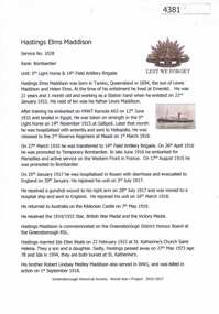
Article, Greensborough Historical Society et al, Hastings Elms Maddison, 1914-1918
... Greensborough Historical Society 34A Glenauburn Road Lower Plenty Lower Plenty melbourne A short article about Hastings Elms Maddison and his service in World War 1. ...A short article about Hastings Elms Maddison and his service in World War 1. Hastings Maddison married into the Beale family of St HelenaOne page, text and colour images.world war 1 project, hastings elms maddison, beale family -
 Greensborough Historical Society
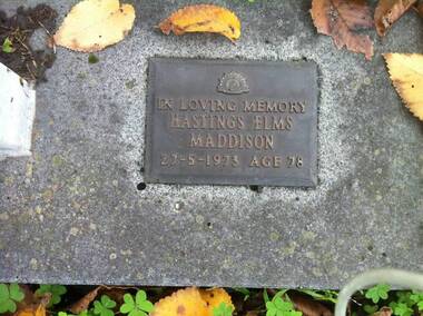
Photograph - Digital image, Marilyn Smith, Grave of Hastings Elms Maddison, St Helena Cemetery, 27/05/1973
... Greensborough Historical Society 34A Glenauburn Road Lower Plenty Lower Plenty melbourne The Grave of Hastings Elms Maddison (ex A.I.F.) ...The Grave of Hastings Elms Maddison (ex A.I.F.) (died 27/05/1973), St Helena Cemetery.St Helena Cemetery was originally the burial place of the Beale family and friends. The first burials took place in the 1850s. There are now over 200 burials.Digital copy of colour photograph (grave)st helena cemetery, maddison family -
Phillip Island and District Historical Society Inc.
Photograph, c 1900
... road, behind withe picket fence, wrought iron filigree on both stories, gabled roofing, grey and white striped awning from roof. Attic on top of building. Two short chimneys front, two large on either side. Side buildings to left of photo. Walking man at front gate. Local History PHOTOGRAPHY Photographs Slides Film Bergins Hotel San Remo Black & White Photograph Miss Elms ...Two storey hotel fronting road, behind withe picket fence, wrought iron filigree on both stories, gabled roofing, grey and white striped awning from roof. Attic on top of building. Two short chimneys front, two large on either side. Side buildings to left of photo. Walking man at front gate.Two storey Victorian Hotel - Bergins Hotel San Remolocal history, photography, photographs, slides, film, bergins hotel san remo, black & white photograph, miss elms san remo -
Phillip Island and District Historical Society Inc.
Photograph, circa 1900
... Road beyond fence. Across the toad, weatherboard Pier Hotel. Residence to left side of 2 storey turret. Building with flag pole. Colonial double-chimneyed homestead style house tucked amongst trees and bushes to right. Local History PHOTOGRAPHY Photographs Slides Film Pier Hotel San Remo Hotels Black & White Photograph Miss Elms ...Reserve with trees left and right. Road beyond fence. Across the toad, weatherboard Pier Hotel. Residence to left side of 2 storey turret. Building with flag pole. Colonial double-chimneyed homestead style house tucked amongst trees and bushes to right.Pier Hotel and adjacent house. A picturesque scene.The Rose Series P700 copyright. Pier Hotel from The Reserve, San Remo, Victorialocal history, photography, photographs, slides, film, pier hotel, san remo, hotels, black & white photograph, miss elms san remo -
Phillip Island and District Historical Society Inc.
Photograph, circa 1900
... road. Bushes between hotels and foreshore. The Genesta, Jetty, Coal Jetty and Jetty leading to what could be baths jutting out into Westernport. Phillip Island foreshore in background. Local History PHOTOGRAPHY Photographs Slides Film Sea Shore San Remo Hotels Black & White Photograph Miss Elms San Remo Sea shore looking across to Phillip Island. ...From left of picture showing the San Remo and Piers Hotels. A horse hitched to part fence on side of road. Bushes between hotels and foreshore. The Genesta, Jetty, Coal Jetty and Jetty leading to what could be baths jutting out into Westernport. Phillip Island foreshore in background.Sea shore looking across to Phillip Island. Large photograph extensive white - grey sky. Road and hotels in front of beach.local history, photography, photographs, slides, film, sea shore san remo, hotels, black & white photograph, miss elms san remo -
 Eltham District Historical Society Inc
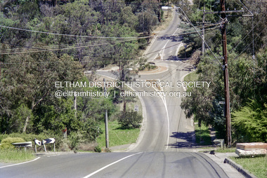
Slide - Photograph, Silver Street, Eltham North, c.1993
... Eltham District Historical Society Inc 728 Main Rd Eltham melbourne Elm Crescent Eltham North Highpoint Crescent Infrastructure Roads silver street 35mm colour positive transparency Mount - Black and White Silver Street, Eltham North Slide Photograph ...35mm colour positive transparency Mount - Black and Whiteelm crescent, eltham north, highpoint crescent, infrastructure, roads, silver street -
 Eltham District Historical Society Inc
Negative - Photograph, Looking south along Ryans Road towards intersection with Kerrie Crescent, Eltham North, c.1998
... elm crescent...eltham north...kerrie crescent...ryans road...Eltham District Historical Society Inc 728 Main Rd Eltham melbourne Taken from opposite intersection with Elm Crescent elm crescent eltham north kerrie crescent ryans road streets Kodak Gold 100-5 Roll of 35mm colour negative film, 8 strips and associated 10 x 15 cm colour print Looking south along Ryans Road towards intersection with Kerrie Crescent, Eltham North Negative Photograph ...Taken from opposite intersection with Elm CrescentRoll of 35mm colour negative film, 8 strips and associated 10 x 15 cm colour printKodak Gold 100-5elm crescent, eltham north, kerrie crescent, ryans road, streets -
 Flagstaff Hill Maritime Museum and Village
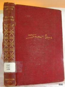
Book, Jonathan Cape, Elmer Gantry, 1930
... Flagstaff Hill Maritime Museum and Village 89 Merri Street Warrnambool great-ocean-road This book “Elmer Gantry” is a novel written by Sinclair Lewis. ...This book “Elmer Gantry” is a novel written by Sinclair Lewis. It was first published in America in 1927. It was published in various languages including French. About SINCLAIR LEWIS (1885-1951) The author was born as Harry Sinclair Lewis in 1885 in Sauk Centre, Minnesota. He was renowned as an American novelist, playwright and short story writer. His first writings were romantic poems and short stories. Six of his novels were published by the time Lewis was 36. Lewis won the 1926 Pulitzer Prize for his book “Arrowsmith” but declined because he had been helped in the writing of it by science writer Paul de Kruif, who received 25% of royalties on the sales. However, Lewis is listed as the sole author. Lewis received the Nobel Prize for Literature in 1930 for his “vigorous and graphic art of description and his ability to create, with wit and humour, new types of characters." He was the first author from the United States to receive this award. Lewis graduated from university in 1907. He worked as a reporter and editor for several publications. He was a prolific writer, publishing dozens of works and numerous articles, and became popular for his satire. Lewis married and divorced twice and died alone from a heart attack due to advanced alcoholism) near Rome on 10th January 1951, aged 66. This book was part of a large group of books referred to as the Pattison Collection, which belonged to the Warrnambool Public Library, part of the Warrnambool Mechanics’ Institute. About RALPH ERIC PATTISON and the ‘PATTISON COLLECTION’ The ‘Pattison Collection’ is a collection of books and records that was originally owned by the Warrnambool Mechanics’ Institute, founded in Warrnambool in 1853. By 1886 the Warrnambool Mechanics’ Institute (WMI) had grown to have a Library, Museum and Fine Arts Gallery, with a collection of “… choice productions of art and valuable specimens in almost every branch and many wonderful national curiosities are now to be seen there, including historic relics of the town and district.” It later included a School of Design. Although it was very well patronised, the WMI was led to ask the City Council to take it over in 1911 due to lack of financial support. In 1935 Ralph Pattison was appointed as City Librarian to establish and organise the Warrnambool Public Library as it was then called. Ralph Eric Pattison was born in Rockhampton, Queensland, in 1891. He married Maude Swan from Warrnambool in 1920 and they set up home in Warrnambool. In 1935 when Pattison accepted the position as City Librarian for the Warrnambool City Council his huge challenge was to make a functional library within two rooms of the Mechanics’ Institute. He tirelessly cleaned, cleared and sorted a disarrayed collection of old books, jars of preserved specimens and other items reserved for exhibition in the city’s museum. He developed and updated the library with a wide variety of books for all tastes, including reference books for students; a difficult task to fulfil during the years following the Depression. He converted all of the lower areas of the building into a library, reference room and reading room for members and the public. The books were sorted and stored using a cataloguing and card index system that he had developed himself. He also prepared the upper floor of the building and established the Art Gallery and later the Museum, a place to exhibit the many old relics that had been stored for years for this purpose. One of the treasures he found was a beautiful ancient clock, which he repaired, restored and enjoyed using in his office during the years of his service there. Ralph Pattison was described as “a meticulous gentleman whose punctuality, floorless courtesy and distinctive neat dress were hallmarks of his character, and ‘his’ clock controlled his daily routine and his opening and closing of the library’s large heavy doors to the minute.” Pattison took leave from 1942 to 1945 to serve in the Royal Australian Navy, Volunteer Reserve as Lieutenant. A few years later he converted one of the Museum’s rooms into a Children’s Library, stocking it with suitable books for the younger generation. This was an instant success. In the 1950’s he had the honour of being appointed to the Victorian Library Board and received more inspiration from the monthly conferences in Melbourne. He was sadly retired in 1959 after over 23 years of service, due to the fact that he had gone over the working age of council officers. However, he continued to take a very keen interest in the continual development of the Library until his death in 1969. THE NEW WARRNAMBOOL LIBRARY When the WMI building was pulled down in 1963 a new civic building was erected on the site and the new Warrnambool Library, on behalf of the City Council, took over all the holdings of the WMI. At this time some of the items were separated and identified as the ‘Pattison Collection’, named after Pattison. Eventually, the components of the WMI were distributed from the Warrnambool Library to various places, including the Art Gallery, Historical Society and Flagstaff Hill. Later some were even distributed to other regional branches of Corangamite Regional Library and passed to and fro. It is difficult now to trace just where all of the items have ended up. The books at Flagstaff Hill Maritime Village generally display stamps and markings from Pattison as well as a variety of other institutions including the Mechanics’ Institute itself.Lewis’s book is significant for its association with the writer, who was the first American to be awarded the Nobel Prize for Literature (1930). This book is significant for its connection with the Pattison Collection which, along with other items at Flagstaff Hill Maritime Village, was originally part of the Warrnambool Mechanics' Institute’s collection. The Warrnambool Mechanics’ Institute collection is primarily significant in its totality, rather than for the individual objects it contains. Its contents are highly representative of the development of Mechanics' Institute libraries across Australia, particularly Victoria. A diversity of publications and themes has been amassed, and these provide clues to our understanding of the nature of and changes in the reading habits of Victorians from the 1850s to the middle of the 20th century. The collection also highlights the Warrnambool community’s commitment to the Mechanics’ Institute, reading, literacy and learning in the regions, and proves that access to knowledge was not impeded by distance. These items help to provide a more complete picture of our community’s ideals and aspirations. The Warrnambool Mechanics Institute book collection has historical and social significance for its strong association with the Mechanics Institute movement and the important role it played in the intellectual, cultural and social development of people throughout the latter part of the nineteenth century and the early twentieth century. The collection of books is a rare example of an early lending library and its significance is enhanced by the survival of an original collection of many volumes. The Warrnambool Mechanics' Institute’s publication collection is of both local and state significance. Title: Elmer Gantry: a novel Author: Sinclair Lewis Publisher: Jonathan Cape, London Date: 1930 Hardback board book covered with red linen. The author’s name is embossed in gold on the front cover. The spine has an embossed gold pattern and text, with the author’s name, book’s title and publisher’s details on it. Also on the spine is a white adhesive label with a typed library call number. Inside the front cover is a printed label covering another label. The book, a novel, is part of the Pattison Collection originally belonging to the Warrnambool Mechanics’ Institute and the Warrnambool Public Library. Embossed on front cover in script ‘Sinclair Lewis’ Embossed on the sping “SINCLAIR / LEWIS”, “ELMER / GANTRY” and “JONATHAN / CAPE” Adhesive label - “PAT / FIC / LEW” Printed label on front endpaper of the Corangamite Regional Library Service Printed label on front endpaper of the Warrnambool Public Library Stamp on front loose endpaper two stamps: “CORANGAMITE REGIONAL LIBRARY SERVICE” and “WARRNAMBOOL MECHANICS’ INSTITUTE”flagstaff hill, warrnambool, shipwrecked coast, flagstaff hill maritime museum, maritime museum, shipwreck coast, flagstaff hill maritime village, great ocean road, book, pattison collection, warrnambool library, warrnambool public library, warrnambool mechanics’ institute, ralph eric pattison, warrnambool books and records, corangamite regional library service, warrnambool city librarian, mechanics’ institute library, victorian library board, warrnambool children’s library, american novel, jonathan cape, sinclair lewis, harry sinclair lewis, 1930 nobel prize for literature, elmer gantry by sinclair lewis -
 Ringwood and District Historical Society
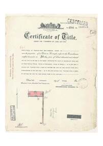
Document, Certificate of Title - Leslie Mills of Plymouth Road, East Ringwood, Farmer - part of Crown Section 20, Parish of Warrandyte, County of Evelyn - 19th January, 1932
... Road), Warranwood, Victroia. Transfers include Alexander William Brown of Tooradin, Farmer - 29th October, 1945, (died 25th June, 1957), Probate granted 28th January, 1958, to Alfred Hart Brown of Dandenong, Estate Agent, and Harry Britten Elms of Cardinia, Gentleman (*** See Probate details below) Oliver Burgess, Grandview Grove Ringwood, Florist - 14th May, 1964, Privatus Proprietary Limited, St.Kilda Road, Melbourne - 27th October, 1977, John Patrick Kelly, Company Director and Yvonne Gloria Kelly, Married Woman, joint proprietors, 10th September, 1980 *** Inventory of Real Estate Assets (for Probate purposes 4/10/1957) detailed in Family Genealogy record for A.W. ...Road), Warranwood, Victroia. Transfers include Alexander William Brown of Tooradin, Farmer - 29th October, 1945, (died 25th June, 1957), Probate granted 28th January, 1958, to Alfred Hart Brown of Dandenong, Estate Agent, and Harry Britten Elms of Cardinia, Gentleman (*** See Probate details below) Oliver Burgess, Grandview Grove Ringwood, Florist - 14th May, 1964, Privatus Proprietary Limited, St.Kilda Road, Melbourne - 27th October, 1977, John Patrick Kelly, Company Director and Yvonne Gloria Kelly, Married Woman, joint proprietors, 10th September, 1980 *** Inventory of Real Estate Assets (for Probate purposes 4/10/1957) detailed in Family Genealogy record for A.W. ...A4 copies of Landata Victoria Historical Search documents - Vol 5781 Fol 1156174.Leslie Mills is now the proprietor of an Estate in Fee-simple subject to the Encumbrances notified hereunder ... 10 acres or thereabouts, together with a right of carriage way over Grandview Grove (later Bemboka Road), Warranwood, Victroia. Transfers include Alexander William Brown of Tooradin, Farmer - 29th October, 1945, (died 25th June, 1957), Probate granted 28th January, 1958, to Alfred Hart Brown of Dandenong, Estate Agent, and Harry Britten Elms of Cardinia, Gentleman (*** See Probate details below) Oliver Burgess, Grandview Grove Ringwood, Florist - 14th May, 1964, Privatus Proprietary Limited, St.Kilda Road, Melbourne - 27th October, 1977, John Patrick Kelly, Company Director and Yvonne Gloria Kelly, Married Woman, joint proprietors, 10th September, 1980 *** Inventory of Real Estate Assets (for Probate purposes 4/10/1957) detailed in Family Genealogy record for A.W. Brown includes: "Grandview Grove, Ringwood Land containing 10 acres or thereabouts situate in Grandview Grove Ringwood being part of Crown Section 20 Parish of Warrandyte County of Evelyn and being the land described in Certificate of Title Volume 5781 Folio 174 on which is erected a 7 room house, a bungalow, shed and 2 glass houses valued by E. Miles, Ringwood - £5077-0-0 -
 Ringwood and District Historical Society
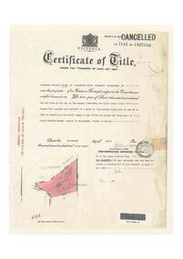
Document, Certificate of Title - Alexander William Brown - part of Crown Section 20, Parish of Warrandyte, County of Evelyn - 16th April, 1948
... Alexander William Brown of Grandview Grove (later Bemboka Road), Ringwood is now the proprietor of an Estate in Fee-simple subject to the Encumbrances notified hereunder ... 2 acres 3 roods 24 and one-half perches or thereabouts, being Lots 33 and 34 Kardinia Crescent, on Plan of Subdivision no.12040. Transfers include Alexander William Brown died 25th June, 1957, Probate granted 28th January, 1958, to Alfred Hart Brown of Dandenong, Estate Agent, and Harry Britten Elms of Cardinia, Gentleman, Oliver Burgess, Grandview Grove Ringwood, Florist - 14th May, 1964, Peter John Woodhead, Transport driver, and Shirley Margaret Woodhead, Married woman - 12th September, 1966. ...Ringwood and District Historical Society 125A Warrandyte Road Ringwood North melbourne Alexander William Brown of Grandview Grove (later Bemboka Road), Ringwood is now the proprietor of an Estate in Fee-simple subject to the Encumbrances notified hereunder ... 2 acres 3 roods 24 and one-half perches or thereabouts, being Lots 33 and 34 Kardinia Crescent, on Plan of Subdivision no.12040. Transfers include Alexander William Brown died 25th June, 1957, Probate granted 28th January, 1958, to Alfred Hart Brown of Dandenong, Estate Agent, and Harry Britten Elms of Cardinia, Gentleman, Oliver Burgess, Grandview Grove Ringwood, Florist - 14th May, 1964, Peter John Woodhead, Transport driver, and Shirley Margaret Woodhead, Married woman - 12th September, 1966. ...A4 copies of Landata Victoria Historical Search documents - Vol 7141 Fol 1428080.Alexander William Brown of Grandview Grove (later Bemboka Road), Ringwood is now the proprietor of an Estate in Fee-simple subject to the Encumbrances notified hereunder ... 2 acres 3 roods 24 and one-half perches or thereabouts, being Lots 33 and 34 Kardinia Crescent, on Plan of Subdivision no.12040. Transfers include Alexander William Brown died 25th June, 1957, Probate granted 28th January, 1958, to Alfred Hart Brown of Dandenong, Estate Agent, and Harry Britten Elms of Cardinia, Gentleman, Oliver Burgess, Grandview Grove Ringwood, Florist - 14th May, 1964, Peter John Woodhead, Transport driver, and Shirley Margaret Woodhead, Married woman - 12th September, 1966. Inventory of Real Estate Assets (for Probate purposes 4/10/1957) detailed in Family Genealogy record for A.W. Brown includes: "Kardinia Crescent, Ringwood - Land containing 2 acres 3 roods 24-1/2 perches situate in Kardinia Crescent Ringwood being Lots 33 and 34 on Plan of Subdivision Number 12040 and being part of Crown Section 20 Parish of Warrandyte County of Evelyn and being the land described in Certificate of Title Volume 7141 Folio 080 valued by E. Miles at £350:0:0 -
 Ringwood and District Historical Society
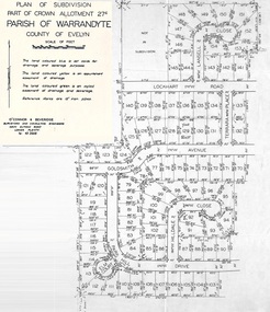
Document - Map, Part of Crown Allotment 27C, Parish of Warrandyte, County of Evelyn, Ringwood, Victoria - c.1970
... Map includes Lockhart Road, Lansell Close, Terrara Place, Goldsmith Avenue, Park Hill Drive, Hilldale Close, and Elm Court, Ringwood, Victoria....Map includes Lockhart Road, Lansell Close, Terrara Place, Goldsmith Avenue, Park Hill Drive, Hilldale Close, and Elm Court, Ringwood, Victoria. ...Photocopy of subdivision plan 75131 Vol 3439 Fol 712 showing numbered residential allotments with property dimensions.Surveyors and Consulting Engineers - O'Connor & Beveridge, Main Eltham Road, Lower Plenty, Tel. 432668. Rubber-stamped "Photocopy - Titles Office Complied 17 Feb 1970". Map includes Lockhart Road, Lansell Close, Terrara Place, Goldsmith Avenue, Park Hill Drive, Hilldale Close, and Elm Court, Ringwood, Victoria. -
 Ringwood and District Historical Society
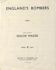
Document - England's Bombers and No longer Mine two songs written by Dulcie Maggs, : Songs and sheet music entitled" England's Bombers" and" No Longer Mine" written by Dulcie Maggs of Ringwood, Victoria. Maggs Family Collection
... Ringwood and District Historical Society 125A Warrandyte Road Ringwood North melbourne Included in the Maggs Family Collection Arthur H. Stockwell Ltd. "Elms ...Included in the Maggs Family Collection4 pages three of music . Words and music by Dulcie Maggs .2 original copies and one later photocopy. One copy of Arthur H. Stockwell Ltd. "Elms Court", Ilfracombe ,N.Devon Made in England. Price 2/- Net. -
Ringwood and District Historical Society
Entry Form - Walkathon, Wal Elms, Hon Chairman, Walkathon Committee, Maroondah Hospital Family Walkathon records of entry and progress - 1971-72, 1971
... Ringwood and District Historical Society 125A Warrandyte Road Ringwood North melbourne Form for recording the entry and progress of a person in a family walkathon for the Maroondah Hospital. Qty 2. A map of the route is shown on the card and there is provision for about 20 sponsors. +Additional Keywords: Elms ...Form for recording the entry and progress of a person in a family walkathon for the Maroondah Hospital. Qty 2. A map of the route is shown on the card and there is provision for about 20 sponsors. +Additional Keywords: Elms, Wal (Hon Chairman) / McGrath, Keith (Hon Sec) / Gough, Mrs -
 Sunshine and District Historical Society Incorporated
Album - Sunshine Advocate and Brimbank Messenger Newspaper Cuttings 1998 - 2010 Scrapbook, 1998-2001
... John's Anglican Church|Robert Eric Parsons|Rubblish dumping issue|Bob & Cyril Parsons|Deer Park Bypass|Sunshine Leisure Centre|Sunshine Station Interchange|Dorothy Price|Sunshine Hospital expansion|Albert & Amy Russell|Wally O'Brien|Hospital pedestrain crossing|Our Lady's Primary School reunion|Mytle Baylis|Darling Albion Flour Mill|Pokie machines|Harricks Cottage|Jack Tighe|Cr Brooke Gujinovic New Brimank Mayor|Jack Collins|Isabella Williams Reserve|Cairnlea developement|Albert Holden|Old Sunsine Police Station Sun Crescent|Big bins|Phyllis Vance|Sunshine Pipe Band|Dick & Elsie Whiting|Historic house denmiolition|Boom gate deley|Brian & Doreen Duffy|Beth Argyle|Sunshine Railway Disaster|Les Hunter|Sunshine Pool closure protest|Clare Brennan|Mickey Vautier|Jack Sheridan|Balam Balam Reserve|Gwen Goedecke|Derrimut Hotel & licensee Wal Elms|Jimmy Gaylor|John & Leone Hawking|Centrelink move|Joan Carstairs|Hampshire Road roadworks|Lloyd McCallum postman retires|Mavis Kittelty & Sunshine Croquet Club closes|Frank O'Connor|Beth Argyle, Don Deeble, Shirley Wallace & Jack Sheridan|Sunshine Anglican Church & Father Stuart Soley|Ian Baker|Morris Street proposed flat development protest|Brimbank's rich cultural history|Church of Christ|Doreen Foster & Albion Tennis Club|Francis & Lillian Allen|Sunshine Wesleyan Methodist Churst|3LO-3AR radio transmitter|George & Gloria Hales|H.V. ...John's Anglican Church|Robert Eric Parsons|Rubblish dumping issue|Bob & Cyril Parsons|Deer Park Bypass|Sunshine Leisure Centre|Sunshine Station Interchange|Dorothy Price|Sunshine Hospital expansion|Albert & Amy Russell|Wally O'Brien|Hospital pedestrain crossing|Our Lady's Primary School reunion|Mytle Baylis|Darling Albion Flour Mill|Pokie machines|Harricks Cottage|Jack Tighe|Cr Brooke Gujinovic New Brimank Mayor|Jack Collins|Isabella Williams Reserve|Cairnlea developement|Albert Holden|Old Sunsine Police Station Sun Crescent|Big bins|Phyllis Vance|Sunshine Pipe Band|Dick & Elsie Whiting|Historic house denmiolition|Boom gate deley|Brian & Doreen Duffy|Beth Argyle|Sunshine Railway Disaster|Les Hunter|Sunshine Pool closure protest|Clare Brennan|Mickey Vautier|Jack Sheridan|Balam Balam Reserve|Gwen Goedecke|Derrimut Hotel & licensee Wal Elms|Jimmy Gaylor|John & Leone Hawking|Centrelink move|Joan Carstairs|Hampshire Road roadworks|Lloyd McCallum postman retires|Mavis Kittelty & Sunshine Croquet Club closes|Frank O'Connor|Beth Argyle, Don Deeble, Shirley Wallace & Jack Sheridan|Sunshine Anglican Church & Father Stuart Soley|Ian Baker|Morris Street proposed flat development protest|Brimbank's rich cultural history|Church of Christ|Doreen Foster & Albion Tennis Club|Francis & Lillian Allen|Sunshine Wesleyan Methodist Churst|3LO-3AR radio transmitter|George & Gloria Hales|H.V. ...These scrap books were put together by Tom Riggs, a past St. Albans Train Station Master, St. Albans Centenary Committee & Sunshine & District Historical Society member and they record a history of a wide range of subjects referring to the Sunshine & District. The following list is only a brief description of each scrapbook. 663.01 - People in official postions 1908|H.V. McKay Factory Gates|Part layout in vicinity of Sunshine Railway Station map 1910|Sunshine Station Signal Box|Harvester Museum|H.V. McKay|H.V. McKay Bulk Store|Sunshine's colorful history|Family of Nathaniel & Mary McKay family tree|Sunshine Smithy|Braybrook residents 1903 & 1906 Sands & McDougal listing|Nat & Joyce Wright|Sunshine Market Palce|Sunshine new police station|Sunshine new post office|S&DHS newspaper articles|Black Powder Mill|Deer Park St. John's Anglican Church|Robert Eric Parsons|Rubblish dumping issue|Bob & Cyril Parsons|Deer Park Bypass|Sunshine Leisure Centre|Sunshine Station Interchange|Dorothy Price|Sunshine Hospital expansion|Albert & Amy Russell|Wally O'Brien|Hospital pedestrain crossing|Our Lady's Primary School reunion|Mytle Baylis|Darling Albion Flour Mill|Pokie machines|Harricks Cottage|Jack Tighe|Cr Brooke Gujinovic New Brimank Mayor|Jack Collins|Isabella Williams Reserve|Cairnlea developement|Albert Holden|Old Sunsine Police Station Sun Crescent|Big bins|Phyllis Vance|Sunshine Pipe Band|Dick & Elsie Whiting|Historic house denmiolition|Boom gate deley|Brian & Doreen Duffy|Beth Argyle|Sunshine Railway Disaster|Les Hunter|Sunshine Pool closure protest|Clare Brennan|Mickey Vautier|Jack Sheridan|Balam Balam Reserve|Gwen Goedecke|Derrimut Hotel & licensee Wal Elms|Jimmy Gaylor|John & Leone Hawking|Centrelink move|Joan Carstairs|Hampshire Road roadworks|Lloyd McCallum postman retires|Mavis Kittelty & Sunshine Croquet Club closes|Frank O'Connor|Beth Argyle, Don Deeble, Shirley Wallace & Jack Sheridan|Sunshine Anglican Church & Father Stuart Soley|Ian Baker|Morris Street proposed flat development protest|Brimbank's rich cultural history|Church of Christ|Doreen Foster & Albion Tennis Club|Francis & Lillian Allen|Sunshine Wesleyan Methodist Churst|3LO-3AR radio transmitter|George & Gloria Hales|H.V. McKay Medal Trade Wing|Lorna Cameron|Noala Flynn|St. Ablans Baptist Church & Ralph Phillips|Apostolic Christian Church|Keilor Christian City Church|Sunshine City Band|Maidstone Our Ladys of Perpetual Church|Waterways|Ron & Margaret Craker 663.02 - Black Powder Mill|St. Albans Greek Orthodox Church of St. Paraskeve|Western Ring Road traffic|Joseph & Frances Testa|Sydneham Kimgdom Hall of Jehovah's Witnesses|Sydenham The Assemblies of God|Michael & Rosalia Skok|Werribee's State Rose Gardens|Tom & Maria Diele|Tom Rigg and the origin of the district's street names|Sunshine & St. Albans Baptist Church|ICI Estate protest|Sunshine Salvation Army Church|Macedonian Orthodox Church|Anita-Marie Neumann|Albanvale path of recongnition|Sunshine Pool action group|Minnie Gorsuch|State Election 2000|Jean Folry & Ilma Weir|Brimbank Uniting Church|Harvester Town book launch - Olwen Ford|Brooke Jujinovic|Keilor Cemetery grave stones|John Howard ignores Braybrook|Norman & Joan Wales|Clare Brennan Drive named after Clare Brennan|Fosseys Sunshine closure|Commonwealth Bank (CBA) Glengala Road closuer|James Frederick McKay|A history of Sunshine|H.V. McKay's Russell Street gates|Barry McMahon|Sunshine Swimming Pool Aquatic centre sale|Keith Buckley|Migrants' move to brave new world|Vasilos & Eugenia Karaoglandis|William Hyett|Darryl Myers|Kathleen Inkster|Sunshine RSL Kevin Keegan, Kevin Bryar & Fred Russell|Barney & Renee Cater|Mona Malouf|George Carter|Sunshine Pottery memorabilia & reunion|Des Johnson Duke Street Aborigine artifacts|Albert Drayton|Two pools planned|Sunshine Pool repairs approved|Olympic Tooch journey through Brimbank|Maurice & Kathleen Sanders|Paul & Suzanna Vicek|Deer Park By Pass Road|Bert & Noreen Craddock|St. Albans Legless Lizards under fire|Sunshine rare orchid scare|St. Albans Road black spot|Viet name for Burke street|Russell Street gates unveiling ceremony|Don & Val Byrnes|Emily Hall|Sunshine Swim centre|Water action plans|Melton Highway sugar gum tree removal by Vicroads|Sunshine Police Station Olympic Rings Brick|Emmaus Catholic School Sydenham opening|Black Powder Mill|Stevens Farm House fire|Yvonne Flack|Frank Gathercole|Commonwealth Bank closurer|Marion Martin|Deer Park State School|Tom & Flo Beagley|Call for railway land buffer|Clarrie Salvador|Braybrook Hotel|Sunshine Harvester Smithy|2000, A year to remember|Bus Re-route hits traders|Sunshine Swimming Pool end of life|Pam Chapman|Prune Goldrick - When the Whistle Blew|Wally O'Brien recalls Deer Park during his childhood|Western Highway / Ballarat Road traffic|Tom Rigg confusing St. Albans bus signs|Rubbish in Deer Park|Phyllis Frost|Basil Morcos|Allan "Titch" Williams|George Thoms|Clarrie Salvator|Tom Dile|Igor Balabin|John McArdie|Sam & Rita Attard|Jack & Dorothy Roberts|Joe De Gabriele|Beth Argyle|John Refshauge surgeon|Bill Fogarity|Brimbank Heritage Listing in peril|Museum of Victoria virtually tour of H.V. McHarvester Factory|Jock McLeod|John & lorna Stainer|Rita Shimmin|Smithy|Nettlefolds - Len Duxon, Betty Scott, Frank Richards, Thelma Burnett, Reg Ratcliffe & Frank Farrugia|Emma Broadhead|Bill Bunting|Gwen Goedecke|Ron Dorre|Sunshine Hospital Redevelopment|Braybrook Squash Centre|Megan Blair|Harvester Town book launch|Tom Rigg rail safty activist|Lloyd & Gislaine Simpson|Sunshine's past revealed|Legless Lizards site Jones Creek|Wetlands|St. Albans time capsule|Cainlea suburb name causing a stir|Agnes Clark|Norman de Pomeroy|Ern & Dot Nicholls|Anton & Maria Gerber|Peter & Margaret McManus|H.V. McKay Offices heritage listing|Cr. Chris Evans out|Two historial walks in Sunshine|Brink Back the H.V. McKay Smithy opening invite|Counicl destroys old files|Harricks Cottage|Special Exhibution Models of Sunshine made farn implements exhibition invite 663.03 - Wally O'Brien|Cr. Chris Evans|Sunshine pool debate|Black Powder Mill|Sydnenham / Hillside Primary School name changes|Say goodbye to Sydnenham, Watergardens|Spalding Reuion|Harry Unger|Gwen Goedecke|Frances Fitzgerald|Preerving Brimbank's significant landmarks|Bernard Reilly kindergarten train|Albert Holden|St. Peters Channel Catholic Church|Terry Muscat|Smithy|Norman & Geoff Pomeroy|Sunshine disaster recalled|Sydneham Railway Station|Sunshine Baseball Club|Albert Evans|Sunshine Pool anger|Albion car crash|Jackson School to loose portables|Black Powder Mill|John Kontek|Harvester basic wage case|Sushine Harvester & Offices complex|Deer Park Primary School|Sunshine underpass / subway shame|Albion Railway Station Rolando & Lilia Antonio|Furlong Road tragery|Anita Ciancio & baby Montana kidnapping|Harricks Cottage|Fence to keep out snakes|Shire of Braybrook Financial & Rate records donated to S&DHS|Bikini protest in Council Chambers|Talintyre Reserve name change from Tallintyre Reserve|Peter Somerville and the Blackbird|Keith Miller|Gerald Griggs|St. Albans Hume & Hovell cairn in the move|Iramoo Committee|Shopping bags ban|Harvester City, the making of Multicultural Sunshine book grant|Susan Jennison|Melchior Bajada|Ray Carlton book donation to Sunshine Library|Hampshire Road connection the Market Place with the Plaza|Girls should be girlsSunshine & Districtsunshine advocate, brimbank messenger, newspaper -
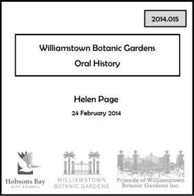 Williamstown Botanic Gardens- Hobsons Bay City Council
Oral History_Williamstown Botanic Gardens_Helen Page, 24/02/2104
... Williamstown Botanic Gardens- Hobsons Bay City Council Cnr Osborne and Giffard Streets Williamstown melbourne The interview is one of a series recorded in 2013-2014 to document memories and experiences of the Williamstown Botanic Gardens A primary source of information on the lobbying that led to master planning for rejuvenation of the Gardens and the formation of the Friends of Williamstown Botanic Gardens. helen-page angela altair mary klestadt mike hirst shelley wood andrew shannon williamstown botanic gardens advisory group master plan sue murray kim sawyer anja lee golden elm advisory group gates pinetum victorian heritage register CD and transcript of interview with Helen Page and her memories and experiences in lobbying for the rejuvenation and long-term viability of the Gardens. Helen was a resident of Williamstown when she contacted local Councillor, Angela Altair, in May 1999 to express her concerns about the destruction of trees in Melbourne Road and the condition of the Williamstown Botanic Gardens. ...The interview is one of a series recorded in 2013-2014 to document memories and experiences of the Williamstown Botanic GardensA primary source of information on the lobbying that led to master planning for rejuvenation of the Gardens and the formation of the Friends of Williamstown Botanic Gardens. CD and transcript of interview with Helen Page and her memories and experiences in lobbying for the rejuvenation and long-term viability of the Gardens. Helen was a resident of Williamstown when she contacted local Councillor, Angela Altair, in May 1999 to express her concerns about the destruction of trees in Melbourne Road and the condition of the Williamstown Botanic Gardens. The result of her communications with Councillor Altair and the Council was the formation of the Landscape Advisory Group and the Williamstown Botanic Gardens Advisory Group. Still an active member of the Williamstown Botanic Gardens Advisory Group, Helen talks of these experiences, how they led to the formation of the Friends Group and her hopes for the future of the Gardens.helen-page, angela altair, mary klestadt, mike hirst, shelley wood, andrew shannon, williamstown botanic gardens advisory group, master plan, sue murray, kim sawyer, anja lee, golden elm, advisory group, gates, pinetum, victorian heritage register -
 Geoffrey Kaye Museum of Anaesthetic History
Photograph
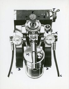
... Geoffrey Kaye Museum of Anaesthetic History ANZCA House 630 St Kilda Road Melbourne melbourne The McKesson Nargraf anaesthetic record was introduced in 1930, created by Dr Elmer I. ...The McKesson Nargraf anaesthetic record was introduced in 1930, created by Dr Elmer I. McKesson.Black and white photograph of a drawing of the head of a McKesson Nargraf anaesthetic record, Model J. The view is from the top looking down onto the machine, showing a round vaporiser with a valve attached to it and two round pressure gauges on either side. The recorder on the top of the photograph does not have a chart attached to it.Each part of the machine has been labelled and handwritten in black ink the letters A - H and J - M on the surface.mckesson nargraf anaesthetic record, anaesthetic equipment