Showing 70 items matching " flood 1956"
-
 Tarnagulla History Archive
Photographs: Laanecoorie Weir In Flood, 1956, 1956
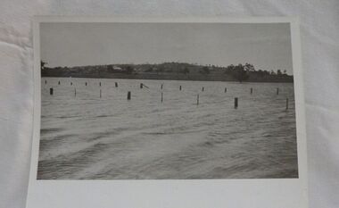
... Photographs: Laanecoorie Weir In Flood, 1956...Series of five small monochrome photographs of Laanecoorie Weir In Flood, on June 3rd 1956. Taken at Laanecoorie, Victoria....Photographs: Laanecoorie Weir In Flood, 1956 Stokes & Son ...David Gordon Collection. Series of five small monochrome photographs of Laanecoorie Weir In Flood, on June 3rd 1956. Taken at Laanecoorie, Victoria.water, flood -
Merbein District Historical Society
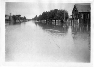
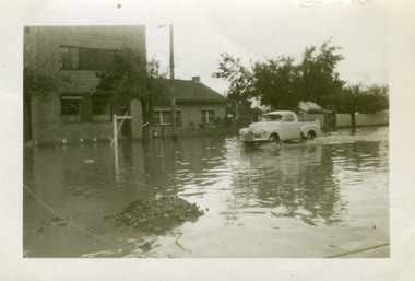
Photograph, River Road 1956 flood, 1956
... River Road 1956 flood...... Murray River Flood 1956...Merbein District Historical Society 36 Box St Merbein the-murray Floods Murray River Flood 1956 River Road 1956 flood Photograph ...floods, murray river flood 1956 -
Merbein District Historical Society
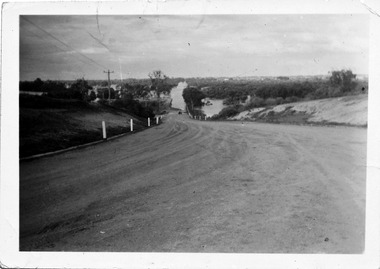
Photograph, Johnston Block 1956 Flood - Ranfurly, 1956
... Johnston Block 1956 Flood - Ranfurly...Murray River Flood 1956...Merbein District Historical Society 36 Box St Merbein the-murray Murray River Flood 1956 Johnston Block 1956 Flood - Ranfurly Photograph ...murray river flood 1956 -
Merbein District Historical Society
Photograph, Krake Children 1956 Flood Johnson Block Ranfurly, 1956
... Krake Children 1956 Flood Johnson Block Ranfurly...Murray River Flood 1956...Merbein District Historical Society 36 Box St Merbein the-murray Murray River Flood 1956 Krake Children 1956 Flood Johnson Block Ranfurly Photograph ...murray river flood 1956 -
Merbein District Historical Society
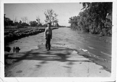
Photograph, Flooded Vines 1956 Flood, 1956
... Flooded Vines 1956 Flood...Murray River Flood 1956...Merbein District Historical Society 36 Box St Merbein the-murray Murray River Flood 1956 Flooded Vines 1956 Flood Photograph ...murray river flood 1956 -
 Charlton Golden Grains Museum Inc
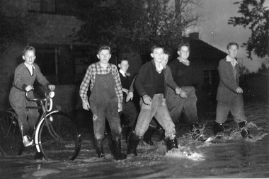
Photograph - 1956 Flood in Charlton
... 1956 Flood in Charlton...1956 flood and a photo of7 schoolboys in High St in the evening. ...Photocopy of original photo of the 1956 flood of 7 school boys in High St....Photograph 1956 Flood in Charlton ...1956 flood and a photo of7 schoolboys in High St in the evening. Boys are Left to Right: Peter Wembridge, Peter Kelly, Geoff Richardson, Ron Clarke, Barry Hooper, Haddy Winsall walking down the flooded High St in May 1956Photocopy of original photo of the 1956 flood of 7 school boys in High St. -
 Tatura Irrigation & Wartime Camps Museum
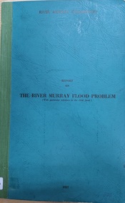
Document - Report on the Murray River Flood Problem 1957 By River Murray Commission, report on the River Murray Flood Problem with reference to 1956 flood
... report on the River Murray Flood Problem with reference to 1956 flood...Report on the River murray Flood Problem, with particular reference to 1956 flood. 1957...Murray River flooding 1956 /1957 River murray Commission. Report on the River murray Flood Problem, with particular reference to 1956 flood. 1957 green cardboard cover, black writing report on the River Murray Flood Problem with reference to 1956 flood Document Report on the Murray River Flood Problem 1957 By River Murray Commission ...green cardboard cover, black writingRiver murray Commission. Report on the River murray Flood Problem, with particular reference to 1956 flood. 1957murray river flooding 1956 /1957 -
 Charlton Golden Grains Museum Inc
Photograph - 1956 Flood in Charlton
... 1956 Flood in Charlton...Halliday St in the Charlton 1956 flood. The power station is on the left and Rogan's house and the Methodist Church is on the right....Black and white photocopy of the original Photograph 1956 Flood in Charlton ...Halliday St in the Charlton 1956 flood. The power station is on the left and Rogan's house and the Methodist Church is on the right.Black and white photocopy of the original -
 Charlton Golden Grains Museum Inc
Photograph - 1956 Flood in Charlton
... 1956 Flood in Charlton...Photocopy of original taken in May 1956 flood of peter Gretgrix in Halliday St near Lambert's house....Black and white photocopy of original photo. Photograph 1956 Flood in Charlton ...Photocopy of original taken in May 1956 flood of peter Gretgrix in Halliday St near Lambert's house.Black and white photocopy of original photo. -
 Charlton Golden Grains Museum Inc
Photograph - 1956 Flood in Charlton
... 1956 Flood in Charlton...A small snapshot of the 1956 flood,taken ar Armstrong St cornr. The CBC bank is on th left of the photo. ...Photo taken by A Howell in May 1956 Sepia original photo Photograph 1956 Flood in Charlton ...A small snapshot of the 1956 flood,taken ar Armstrong St cornr. The CBC bank is on th left of the photo. A utility truck is driving through the water. Photo taken by A Howell in May 1956Sepia original photo -
Merbein District Historical Society
Photograph, Pumphill Merbein making sandbags 1956 Flood, 1956
... Pumphill Merbein making sandbags 1956 Flood...Merbein District Historical Society 36 Box St Merbein the-murray Pumphill Merbein making sandbags 1956 Flood Photograph ... -
Merbein District Historical Society
Book, Merbein Glimpses into the Fifty Years as an Irrigation Settlement, Mar.2009
... ... Flood 1956...Merbein District Historical Society 36 Box St Merbein the-murray Bernadette Wells White Cliffs Blandowski Land Allottments Pumping Station Merbein Football Club Recreation Town Allotments Businesses Schools Merbein Soldiers Kenny Park Memorial Pillars The Common Merbein Halls Flood 1956 50th Anniversary Parade Merbein Glimpses into the Fifty Years as an Irrigation Settlement Book ...bernadette wells, white cliffs, blandowski, land allottments, pumping station, merbein football club, recreation, town allotments, businesses, schools, merbein soldiers, kenny park, memorial pillars, the common, merbein halls, flood 1956, 50th anniversary parade -
Merbein District Historical Society
Journal - Quarterly, Merbein Historian - MDHS - No 29 (2 copies) Sept.2007, Sept.2007
... ... Murray River Flood 1956...Merbein District Historical Society 36 Box St Merbein the-murray Anniversary 10th MDHS Leon Wagner Life Membership Wedding Parade Wentworth Junction Steam Rally William Blandowski Merbein Houses Arthur Lever Murray River Flood 1956 Francis Nettleton Merbein Historian - MDHS - No 29 (2 copies) Sept.2007 Journal Quarterly ...anniversary 10th mdhs, leon wagner, life membership, wedding parade, wentworth junction steam rally, william blandowski, merbein houses, arthur lever, murray river flood 1956, francis nettleton -
 Merbein District Historical Society
Photograph, Pump Hill Merbein, 1956
... Flood - 1956...Merbein District Historical Society 36 Box St Merbein the-murray Flood - 1956 Pump Hill Merbein Photograph ...flood - 1956 -
Merbein District Historical Society
Photograph, Pump Hill Merbein, 1956
... Flood - 1956...Merbein District Historical Society 36 Box St Merbein the-murray Flood - 1956 Jack & Jim Case Don Kimpton Mick Cudmore Geoff Kimpton Pump Hill Merbein Photograph ...flood - 1956, jack & jim case, don kimpton, mick cudmore, geoff kimpton -
 Merbein District Historical Society
Photograph, Pump Hill Merbein, 1956
... ... Flood - 1956...Merbein District Historical Society 36 Box St Merbein the-murray Pump Hill Merbein Flood - 1956 Pump Hill Merbein Photograph ...pump hill merbein, flood - 1956 -
 Merbein District Historical Society
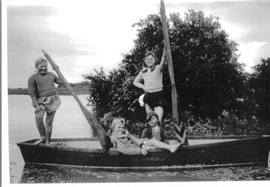
Photograph, Murray River flood Krake children boat, 1956
... Johnston Block 1956 Flood - Lake Hawthorn Gibbs St...Merbein District Historical Society 36 Box St Merbein the-murray Marlene Krake Geoffrey Krake Heather Killingbeck Lesley Killingbeck Johnston Block 1956 Flood - Lake Hawthorn Gibbs St Murray River flood Krake children boat Photograph ...marlene krake, geoffrey krake, heather killingbeck, lesley killingbeck, johnston block 1956 flood - lake hawthorn gibbs st -
Tatura Irrigation & Wartime Camps Museum
CD, James Lally, Recollections of Tatura - Lally
... Collection includes coronation procession 1953, Queen's visit 1954, floods 1956, old Tatura golf club 1964, Hill Top 1967....Collection includes coronation procession 1953, Queen's visit 1954, floods 1956, old Tatura golf club 1964, Hill Top 1967. local history CD in a clear plastic rectangle cover. ...Collection of photographs taken by Dr Desmond Lally and recorded onto CD by James Lally (son). Collection includes coronation procession 1953, Queen's visit 1954, floods 1956, old Tatura golf club 1964, Hill Top 1967.CD in a clear plastic rectangle cover. Black text on a silver disc. Contents of CD written on a piece of Verbatim Paper.local history -
 Eltham District Historical Society Inc
Album - Photograph, J.A. McDonald, Yarra Glen-Glenburn Road, Apr. 1956
... Showing first flood debris April 1956...Eltham District Historical Society Inc 728 Main Rd Eltham melbourne Showing first flood debris April 1956 Record of various Shire of Eltham infrastructure works undertaken during the period of 1952-1962 involving bridge and road reconstruction projects, sometimes with Eltham Shire Council Project Reference numbers quoted. ...Showing first flood debris April 1956Record of various Shire of Eltham infrastructure works undertaken during the period of 1952-1962 involving bridge and road reconstruction projects, sometimes with Eltham Shire Council Project Reference numbers quoted. It was during this period that a number of significant improvements were made to roads and new bridges constructed within the shire that remain in place as of present day (2022). In many situations, the photos provide a tangible visible record of infrastructure that existed throughout the early days of the Shire. The album was put together by or under the direction of the Shire Engineer, J.A. McDonald.infrastructure, shire of eltham, bridge construction, jehosophat creek, road construction, yarra glen-glenburn road, 1956-04 -
 Eltham District Historical Society Inc
Album - Photograph, J.A. McDonald, Eltham-Diamond Creek Road, 21 Oct. 1953
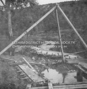
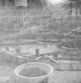
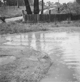
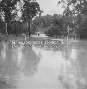
... 18 October 1956 Flooding on downstream line from Diamond Creek side...Eltham District Historical Society Inc 728 Main Rd Eltham melbourne 18 October 1956 Flooding on downstream line from Diamond Creek side Record of various Shire of Eltham infrastructure works undertaken during the period of 1952-1962 involving bridge and road reconstruction projects, sometimes with Eltham Shire Council Project Reference numbers quoted. ...18 October 1956 Flooding on downstream line from Diamond Creek sideRecord of various Shire of Eltham infrastructure works undertaken during the period of 1952-1962 involving bridge and road reconstruction projects, sometimes with Eltham Shire Council Project Reference numbers quoted. It was during this period that a number of significant improvements were made to roads and new bridges constructed within the shire that remain in place as of present day (2022). In many situations, the photos provide a tangible visible record of infrastructure that existed throughout the early days of the Shire. The album was put together by or under the direction of the Shire Engineer, J.A. McDonald.infrastructure, road construction, shire of eltham, bridge construction, eltham north, floods, floodwater, glen park bridge, 1956-10-18, diamond creek (creek), eltham, railway parade, wattletree road, wattletree road bridge -
 Eltham District Historical Society Inc
Album - Photograph, J.A. McDonald, Eltham-Yarra Glen Road, 18 Oct. 1956
... Eltham-Yarra Glen Road Proposed crossing of Plenty River at Lower Plenty. Floods 18th October 1956....Eltham District Historical Society Inc 728 Main Rd Eltham melbourne Eltham-Yarra Glen Road Proposed crossing of Plenty River at Lower Plenty. Floods 18th October 1956. Record of various Shire of Eltham infrastructure works undertaken during the period of 1952-1962 involving bridge and road reconstruction projects, sometimes with Eltham Shire Council Project Reference numbers quoted. ...Eltham-Yarra Glen Road Proposed crossing of Plenty River at Lower Plenty. Floods 18th October 1956.Record of various Shire of Eltham infrastructure works undertaken during the period of 1952-1962 involving bridge and road reconstruction projects, sometimes with Eltham Shire Council Project Reference numbers quoted. It was during this period that a number of significant improvements were made to roads and new bridges constructed within the shire that remain in place as of present day (2022). In many situations, the photos provide a tangible visible record of infrastructure that existed throughout the early days of the Shire. The album was put together by or under the direction of the Shire Engineer, J.A. McDonald.infrastructure, road construction, shire of eltham, bridge construction, eltham-yarra glen road, 1956-10-18, floods, floodwater, lower plenty, plenty river -
 Charlton Golden Grains Museum Inc
Photograph, Cameron, Ian, 01/02/1973
... Of the 1973 flood at Gordon Park and Croquet Club. Highest flood since 1956, 25 feet 1 1/2 at the bridge, 4 inches of rain fell in the catchment. ...Of the 1973 flood at Gordon Park and Croquet Club. Highest flood since 1956, 25 feet 1 1/2 at the bridge, 4 inches of rain fell in the catchment. ...Taken by the editor of The Charlton Tribune Ian Cameron. Of the 1973 flood at Gordon Park and Croquet Club. Highest flood since 1956, 25 feet 1 1/2 at the bridge, 4 inches of rain fell in the catchment. Road damage after the flood was estimated to be $74,800.Large sepia photograph unframed, creased in top RH corner, surface torn on left edge. Unmountedgordon park, croquet club, charlton, floods -
 Eltham District Historical Society Inc
Album - Photograph, J.A. McDonald, Eltham-Diamond Creek Road, 21 Oct. 1953
... 18 October 1956 Flooding on Diamond Creek 17th October 1956 (not max.) ...Eltham District Historical Society Inc 728 Main Rd Eltham melbourne 18 October 1956 Flooding on Diamond Creek 17th October 1956 (not max.) ...18 October 1956 Flooding on Diamond Creek 17th October 1956 (not max.) This view is looking southwest along Railway Parade (now present-day Gastons Road) past Mrs Lucy Egan's house now owned by the Bakos family, purchased by Mrs Heather Bakos in 1960Record of various Shire of Eltham infrastructure works undertaken during the period of 1952-1962 involving bridge and road reconstruction projects, sometimes with Eltham Shire Council Project Reference numbers quoted. It was during this period that a number of significant improvements were made to roads and new bridges constructed within the shire that remain in place as of present day (2022). In many situations, the photos provide a tangible visible record of infrastructure that existed throughout the early days of the Shire. The album was put together by or under the direction of the Shire Engineer, J.A. McDonald.infrastructure, road construction, shire of eltham, bridge construction, eltham north, floods, floodwater, glen park bridge, 1956-10-18, diamond creek (creek), eltham, railway parade, wattletree road, wattletree road bridge, gastons road -
 Wycheproof & District Historical Society Inc.
Photograph, Mr Ernie Taylor, Cooroopajerrup Creek 1923, 1923 (exact)
... In more recent times the Wycheproof channel prevented the major floods of 1956 and 1973 from following the old river course. ...In more recent times the Wycheproof channel prevented the major floods of 1956 and 1973 from following the old river course. ...The semi-mythical stream, the Cooroopajerrup Creek. Before there were any channel banks and formed roads, this creek shared the Avoca flood waters with the Tyrrell Creek. In more recent times the Wycheproof channel prevented the major floods of 1956 and 1973 from following the old river course. Also there is said to have been some shifting of the sand-hills at Teddywaddy which have blocked much of the old Cooroopajerrup flow. Little is known of earlier records, but The Mount Wycheproof Ensign records flooding of the creek in 1909. 2011 saw the Cooroopajerrup flow again after 88 years. This 2011 photo was taken at about the same position as the 1923 photo. The modern steel roadway fence is submerged. see-Photograph-Record No 001997.Copy of a B&W photograph of the Cooroopajerrup-Creek in flood-1923. To the north is Mount-Wycheproof, with the hospital barely visible behind the trees just left of centre, and a few scattered dwellings. The nearer railway-fence follows the road leading to the current saleyards.The outer fence has been replaced with a modern steel fence.None1923, cooroopajerrup creek, flood, mount wycheproof -
 Mission to Seafarers Victoria
Journal (item) - Periodicals-Annual, Shiplovers' Society of Victoria, The Annual Dog Watch
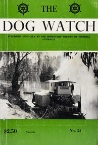
... She was brought out of retirement during the 1956 floods to do trips up the Murrumbidgee River. ...She was brought out of retirement during the 1956 floods to do trips up the Murrumbidgee River. ...This journal provides the reader with glimpses of the adventures and hardships of a seaman's life. Many of the stories are of sailing ships. PS Etona was built in 1898 at Milang, South Australia as a missionary church steamer for the Church of England. The Etona's run was from Mannum, South Australia, where she was based up to Renmark. As churches were built in river tower she was no longer required and in 1912 she was sold to Captain Arch Conner who used her as a fishing steamer at Boundary Bend for many years. She was brought out of retirement during the 1956 floods to do trips up the Murrumbidgee River. She was eventually bought by interest in Echuca and restoration was commenced in 1962. The Etona, now fully restored with her original steam engine can now be seen moored along side the historic wharf at Echuca.Contributes to our knowledge of the importance of shipping and places on record those stories of the sea which would otherwise be lost.Contents Foreword - G. F. Tilley - 5 The "Etona" - H. Vaughan Evans - 6 Editorial - Russell Hemingway - 11 The Old Lady Of The River - Captain J. Gaby - 19 "Takapuna" Interlude On A Moonless Night - E. Harper - 31 Maritime Museum of Tasmania - J. Miller - 34 The Confederate Raiders "Florida" and "Alabama" - A. R. Osmond - 36 "Ease After War . . . Doth Greatly Please" - Captain W. J. Cowling - 44 Mutiny At Sea - P. R. Wilkins - 49 War Service In The Indian Ocean - H. Mossman - 51 Cape Horn - Captain Eino Koivistoinen - 57 "Tragedy of Loss" - Jonathan john - 61 The End of The "Queen Elizabeth" - Bradley J. Newell - 62 London Could Cope With Him - Dr. Stanislaw Bernatt - 68 Three Ships Canals - N. S. Smith - 69 The Loss Of The "Eyoshi Maru" - Captain M. B. Glasier - 77 A Small Consignment But Valuable - J. B. Hodgson - 85 Lowden and The "Candida" - D. R. Rickard - 87 "Lauriston" Sails On - F. W. Rudd - 89 Confusion of Identities, "Young Australian", "Young Australia" and "Carl" - J. M. MacKenzie - 93 Rescue from "Clarissa", 1957 - Captain Leif Asklund - 97 Journey Home - Captain W. E. Eastoe - 100 Disaster At Blanket Bay - J. K. Loney - 104 The End Of The "Antiope" - Captain Bruce Bell - 106 The "Great Britain" - C. E. Bonwick - 108 Search The Coast To Shark Bay - Rear-Admiral Charles Adair U.S.N. - 110 The "Polly Woodside" Family - Rev. H. W. Coffey - 121 Book Reviews - 123sailing ships, steamships, shipping, seafaring life, shiplovers' society of victoria, dog watch, murray river, paddlesteamers, echuca, etona, ps etona -
 Eltham District Historical Society Inc
Album - Photograph, J.A. McDonald, Eltham-Diamond Creek Road, 21 Oct. 1953
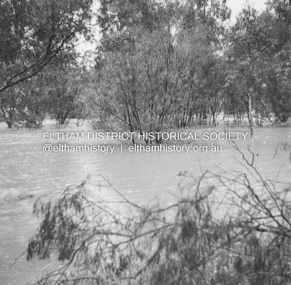
... 18 October 1956 Flood level on road at corner of Railway Parade. ...Eltham District Historical Society Inc 728 Main Rd Eltham melbourne 18 October 1956 Flood level on road at corner of Railway Parade. ...18 October 1956 Flood level on road at corner of Railway Parade. On the immediate left out of view is Mrs Lucy Egan's home. That house still stands today nestled up against the Wattletree Road Bridge on the other side built in 1959 and is owned by the Bakos family purchased by Mrs Heather Bakos in 1960.. Prior to the Wattletree Road bridge being built, Railway Parade extended up the alignment of present-day Gastons Road to the Eltham-Diamond Creek road which ran past the entrance of the present-day carpark for Edendale Farm. This view is looking west across the Glen Park Bridge, and the beginning of Wattletree Road which sweeps around to the right in the distance. Progress Road does not exist though a road reserve is present on maps.Record of various Shire of Eltham infrastructure works undertaken during the period of 1952-1962 involving bridge and road reconstruction projects, sometimes with Eltham Shire Council Project Reference numbers quoted. It was during this period that a number of significant improvements were made to roads and new bridges constructed within the shire that remain in place as of present day (2022). In many situations, the photos provide a tangible visible record of infrastructure that existed throughout the early days of the Shire. The album was put together by or under the direction of the Shire Engineer, J.A. McDonald.infrastructure, road construction, shire of eltham, bridge construction, eltham north, floods, floodwater, glen park bridge, 1956-10-18, diamond creek (creek), eltham, railway parade, wattletree road, wattletree road bridge, gastons road -
 Bendigo Military Museum
Photograph - Royal Australian Survey Corps Surveyors in the Field – Project Cutlass, New Guinea, 1956 – 1957
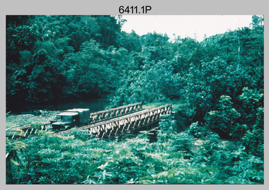
... 1956. Unidentified surveyors assessing recovery of their vehicle after bridge collapsed over flooded creek on west side of New Ireland. .4) - Photo, colour, 1956. ...1956. Unidentified surveyors assessing recovery of their vehicle after bridge collapsed over flooded creek on west side of New Ireland. .4) - Photo, colour, 1956. ...This is a set of 23 photographs of surveyors and support staff in the field undertaking tasks in New Guinea 1956 – 1957. The surveyors were employed in the establishment of mapping and geodetic control for Project Cutlass, the “Ship-Shore” survey of the New Ireland province. In this survey operation surveyors used theodolites to observe horizontal and vertical angles and chains to measure base line distances between survey stations. Bob Skitch shown in photo .7P was in the 2nd year of his career in the Australian Army. He achieved the rank of Lieutenant-Colonel, and his last appointment was the CO of the Army Survey Regiment from 1976 to 1980.This is a set of 23 photographs of surveyors and support staff in the field undertaking duties during Project Cutlass located in New Ireland, New Guinea 1956 – 1957. The photographs were printed on photographic paper and are part of the Army Survey Regiment’s Collection. The photographs were scanned at 300 dpi. .1) - Photo, colour, 1956. Surveyors travelling main road from Kavieng to Namatanai, New Ireland. .2) - Photo, colour, 1956. Unidentified surveyors assessing recovery of their vehicle after bridge collapsed on west side of New Ireland. .3) - Photo, colour, 1956. Unidentified surveyors assessing recovery of their vehicle after bridge collapsed over flooded creek on west side of New Ireland. .4) - Photo, colour, 1956. Survey personnel L to R: Bev Uwins, John Lambie, Bob Thompson, New Ireland. .5) - Photo, colour, 1956. Survey base camp, New Ireland. .6) - Photo, black & white, 1956-1957. Geoff Helsham with possible human remains, New Ireland. .7) - Photo, black & white, 1956-1957. Bob Skitch undertaking survey observations using Wild T2 theodolite, New Ireland. .8) - Photo, black & white, 1956-1957. Chas Beach undertaking survey observations using Wild T2 theodolite, New Ireland. .9) & .10) - Photo, black & white, 1956-1957. Kev Parker (cook) New Ireland. .11) - Photo, colour, 1957. Brian Berkery taking a break, Top Manor Island, Lihir Island Group off New Ireland. Latitude -2° 46”, Longitude 152° 40”. .12) - Photo, colour, 1957. Survey base camp L to R: Chas Beach, Bev Uwins, Feni Islands, New Ireland. Latitude -4° 05”, Longitude 153° 45”. .13) - Photo, colour, 1957. A Hous Kiap. (Kiaps, known formally as district officers and patrol officers, were travelling representatives of the British and Australian governments), New Ireland. .14) & .15) - Photo, colour, 1957. L to R: Joe Farrington, Tom Royle Bob undertaking survey observations using theodolites from an improvised timber tower, New Ireland. .16) & .17) - Photo, colour, 1957. US Army ship FS216 used for ship-to-shore triangulation docked at Rabaul, New Britain. .18) - Photo, colour, 1957. US Army ship FS216 used for ship-to-shore triangulation docked at Kavieng, New Ireland. Sight target on top of mast. .19) - Photo, colour, 1957. Survey personnel onboard US Army ship FS392, L to R: Peter Frodsham, Bob Thompson, Doc Reid, John Underwood, remainder unidentified, New Ireland. .20) - Photo, colour, 1957. Survey base line party heading ashore, New Ireland. .21) - Photo, colour, 1957. Survey personnel rowing US Army assault boat L to R: Kev Parker, Chas Beach, folded up survey beacons overhanging stern, New Ireland. .22) - Photo, colour, 1957. Les Bailey onboard US Army ship departing Rabaul, New Britain for Brisbane. .23) - Photo, colour, 1957. Ron Newman onboard US Army ship departing Rabaul, New Britain for Brisbane. Active volcano in background..1P to .23P annotated on back – ‘Operation Cutlass’, personnel names, the year and the location. royal australian survey corps, rasvy, army survey regiment, fortuna, a, army svy regt, asr, surveying -
 Port of Echuca
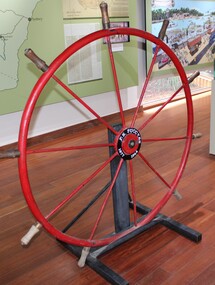
Instrument - Steering Wheel, PS Success, 1877
... Importantly, the Success was the last paddlesteamer to be working on the river system right up until the 1956 floods rescuing sheep and wool. The steering wheel is an important original element of the PS Success and her hopes for restoration one day. ...This steering wheel is from the PS Success. The PS Success was built in Moama in 1877 by GB Air for Westwood & Air. The Success towed barges of sawn red gum, wool & other cargo along the Darling and Murray Rivers as well as running as a passenger boat from Swan Hill to Mildura during 1915-16. The Success ended her working life in 1957 and was put up on the bank at Neds Corner, 80kms west of Mildura. The PS Success was donated to the Riverboat Historical and Preservation Society of Mildura with plans for full restoration but with funds becoming extremely difficult to secure, the Shire of Campaspe was approached to take ownership in 2009 to enable further restoration when possible. The Riverboat Preservation Society also donated this original steering wheel.The PS Success was an important vessel built in the Echuca area during the height of the Riverboat trade in the 1870s. She had a long, colourful history towing barges on the Murray River and in particular in the Mildura, Wentworth and Ned's Corner regions. Importantly, the Success was the last paddlesteamer to be working on the river system right up until the 1956 floods rescuing sheep and wool. The steering wheel is an important original element of the PS Success and her hopes for restoration one day. Red metal steering wheel with 10 spokes sitting on a heavy iron wheel stand. -
 Port of Echuca
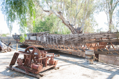
Functional object - Paddlesteamer hull, Westgood & Air, P.S Success, 1877
... She was the last paddlesteamer to be working on the river system right up until the 1956 floods towing the barge Vega, where at one point both boat and barge smashed into trees on a wild, uncontrolled journey downstream where she was damaged and later lay stranded on Ned's Corner. ...The PS Success was built in Moama in June 1977 by GB Air for Westwood & Air. It was built to tow barges of cargo along the Darling and Murray rivers, as well as running as a passenger boat from Swan Hill to Mildura during 1915-16. The Success was the last paddlesteamer actively working on the river when she performed several rescue voyages to flood bound properties along on the Darling River, rescuing sheep and a large cargo of wool. The vessel ended her working life in 1957 and was put up on the bank at Ned's corner, 80km west of Mildura. In 1996, the Pollard family donated the vessel to the Riverboat Historical and Preservation Society of Mildura with plans to restore her to her former glory. This project became increasingly difficult for the dedicated volunteers to handle and the Port of Echuca took ownership in 2009 in the hopes that further restoration work can be done at the Port. The Succes is currently on static display at the northern end of the Port of Echuca. The PS Success had a long, colourful history towing barges on the Murray River and in particular in the Mildura, Wentworth and Ned's Corner regions. She was the last paddlesteamer to be working on the river system right up until the 1956 floods towing the barge Vega, where at one point both boat and barge smashed into trees on a wild, uncontrolled journey downstream where she was damaged and later lay stranded on Ned's Corner.Composite timber hull, 3-inch red gum planks on angle iron frames. Carvel built with counter stern and straight stem. Originally had a round keel and a pair of 35hp engines. Success paddle steamers, echuca boat builders, westwood & air, p.s. success