Showing 310 items matching " geological survey."
-
 Federation University Historical Collection
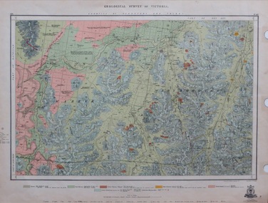
Map, Geological Survey of Victoria, 1913
... Geological Survey of Victoria......geological survey of victoria...Geological Survey of Victoria...Barker Library (top floor) Mount Helen goldfields victoria geological survey of victoria gladstone talbot Printed colour map on paper Geological Survey of Victoria Map Map Geological Survey of Victoria ...Printed colour map on papervictoria, geological survey of victoria, gladstone, talbot -
 Clunes Museum
Book, ROBERT S. BRAIN, BULLETINS OF THE GEOLOGICAL SURVEY OF VICTORIA, 1903
... BULLETINS OF THE GEOLOGICAL SURVEY OF VICTORIA......GEOLOGICAL SURVEY...DEPARTMENT OF MINES, GEOLOGICAL SURVEY OF VICTORIA...BOOK - BULLETINS OF THE GEOLOGICAL SURVEY OF VICTORIA.. NO. 6 THE CLUNES GOLDFIELD BY W M. ...DEPARTMENT OF MINES, GEOLOGICAL SURVEY OF VICTORIA local history mining GEOLOGICAL SURVEY BULLETINS OF THE GEOLOGICAL SURVEY OF VICTORIA, AUSTRALIA. ...BULLETINS OF THE GEOLOGICAL SURVEY OF VICTORIA, AUSTRALIA.BOOK - BULLETINS OF THE GEOLOGICAL SURVEY OF VICTORIA.. NO. 6 THE CLUNES GOLDFIELD BY W M. BRADFORD.non-fictionBULLETINS OF THE GEOLOGICAL SURVEY OF VICTORIA, AUSTRALIA.local history, mining, geological survey -
 Stawell Historical Society Inc
Book, Norman Taylor, Geological Survey of Victoria No3, Geological Survey of Stawell, 1875-1876
... Geological Survey of Victoria No3, Geological Survey of Stawell...Geological Survey of Stawell 1875/76 by Norman Taylor, Geological Surveyor...Geological Survey of Victoria No.3 Geological Survey of Stawell Norman Taylor 1875/76...Stawell Historical Society Inc 46 Longfield St Stawell grampians Geological Survey of Stawell 1875/76 by Norman Taylor, Geological Surveyor stawell mining Geological Survey of Victoria No.3 Geological Survey of Stawell Norman Taylor 1875/76 Yellow Card Front and Rear Cover with B/W Picture of mining scene. with black Plastic spine Geological Survey of Victoria No3, Geological Survey of Stawell Book Norman Taylor ...Geological Survey of Stawell 1875/76 by Norman Taylor, Geological SurveyorYellow Card Front and Rear Cover with B/W Picture of mining scene. with black Plastic spineGeological Survey of Victoria No.3 Geological Survey of Stawell Norman Taylor 1875/76stawell mining -
Stawell Historical Society Inc
Map, Geological Survey Office, Sloanes & Scotchmans united Mine, December 1916
... Sloane & Scotchman's Geological Survey Map 1916 Showing Underground Drives...Geological Survey Office Ballarat December 1916 ...Geological Survey Office...Stawell Historical Society Inc 46 Longfield St Stawell grampians mining gold map Geological Survey Office Ballarat December 1916 Sloane & Scotchman's Geological Survey Map 1916 Showing Underground Drives Sloanes & Scotchmans united Mine Map Geological Survey Office ...Sloane & Scotchman's Geological Survey Map 1916 Showing Underground DrivesGeological Survey Office Ballarat December 1916 mining, gold, map -
Clunes Museum
Document - GEOLOGICAL SURVEY, PROFESSOR. J.W.GREGORY, F.R.S, D.SC., DIRECTOR, CIRCA 1903
... GEOLOGICAL SURVEY......geological survey...BULLETINS OF THE GEOLOGICAL SURVEY OF VICTORIA...Clunes Museum 36 Fraser Street enter building through Collins Place Clunes goldfields NO 6 THE CLUNES GOLD FIELDS local history docoments geological survey mining BULLETINS OF THE GEOLOGICAL SURVEY OF VICTORIA Document GEOLOGICAL SURVEY PROFESSOR. ...NO 6 THE CLUNES GOLD FIELDSBULLETINS OF THE GEOLOGICAL SURVEY OF VICTORIAlocal history, docoments, geological survey, mining -
Bendigo Historical Society Inc.
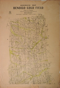
Map - GOLDEN SQUARE GEOLOGICAL SURVEY, 1992
... GOLDEN SQUARE GEOLOGICAL SURVEY......geological survey...Golden Square Geological Survey of Goldfields Coloured map....Golden Square Geological Survey of Goldfields Coloured map. Map GOLDEN SQUARE GEOLOGICAL SURVEY ...BHS CollectionGolden Square Geological Survey of Goldfields Coloured map.Dept of manufacturing and Industry Development.bendigo, gold mining, geological survey -
University of Melbourne, Burnley Campus Archives
geological survey - Map, Geological Survey of Victoria - Australia 1:63 360 - A. Geelong B. Portarlington, 1963
... Geological Survey of Victoria - Australia 1:63 360 - A. ......Victoria Geological Survey...B. Coloured geological survey map of Portarlington, Victoria. ...Portarlington geological survey Map ...A. Coloured geological survey map of Geelong area: showing sedimentary and igneous rock formations and contours. B. Coloured geological survey map of Portarlington, Victoria. By Dept. Of Mines, Melbourne. Scale 1 Mile to 1 inchgeelong, portarlington, victoria geological survey -
Lakes Entrance Historical Society
Map - Bairnsdale Geological Survey of Victoria 1969, Geological Survey of Victoria, 1969
... Bairnsdale Geological Survey of Victoria 1969...Geological Survey of Victoria...VTMH10563 A and B. 2 pages Map Bairnsdale Geological Survey of Victoria 1969 Geological Survey of Victoria ...Shows area around Sarsfield Wyung Bumberrah Colquhoun North Broadsland Moormurng Bairnsdale Goon Nure. VTMH10563 A and B. 2 pagesgeology, waterways, townships -
 Federation University Historical Collection
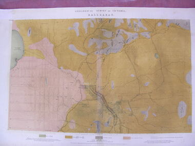
Map - Geological Survey, J. Phillips, Geological Survey of Victoria - Ballarat, 1857, 10/1858
... Geological Survey...Geological Survey of Victoria - Ballarat, 1857...Barker Library (top floor) Mount Helen goldfields ballarat geological geology Geological plan Main Road Camp Golden Point Pennyweight Hill Clayton Hill Ballaarat Cemetery Bakery Hill Specimen Hill Soldiers Hill Nightingale Lead native youth black hill flat White flat mining mines Eureka Lead Old Post Office Hill Geological map of the Ballarat District featuring four colours. Geological Survey of Victoria - Ballarat, 1857 Map Geological Survey J. ...Geological map of the Ballarat District featuring four colours.ballarat, geological, geology, geological plan, main road, camp, golden point, pennyweight hill, clayton hill, ballaarat cemetery, bakery hill, specimen hill, soldiers hill, nightingale lead, native youth black hill flat, white flat, mining, mines, eureka lead, old post office hill -
Clunes Museum
Book, E J DUNN, MEMOIRS OF THE GEOLOGICAL SURVEY OF VICTORIA. NO. 12 LIST OF NUGGETS FOUND IN VICTORIA, 1979
... MEMOIRS OF THE GEOLOGICAL SURVEY OF VICTORIA. NO. 12 LIST OF NUGGETS FOUND IN VICTORIA......GEOLOGICAL SURVEY...MEMOIRS OF THE GEOLOGICAL SURVEY OF VICTORIA. NO. 12 LIST OF NUGGETS FOUND IN VICTORIA. 69 PAGES LISTING WEIGHTS, LOCATION AND DETAILS OF NUGGETS FOUND....MEMOIRS OF THE GEOLOGICAL SURVEY OF VICTORIA. NO. 12 LIST OF NUGGETS FOUND IN VICTORIA Book BOOK E J DUNN ...LIST OF GOLD NUGGETS FOUND IN VICTORIA.YELLOW SOFT COVERED BOOK. MEMOIRS OF THE GEOLOGICAL SURVEY OF VICTORIA. NO. 12 LIST OF NUGGETS FOUND IN VICTORIA. 69 PAGES LISTING WEIGHTS, LOCATION AND DETAILS OF NUGGETS FOUND.non-fictionLIST OF GOLD NUGGETS FOUND IN VICTORIA.mining, gold mining, nuggets, geological survey, fawcett -
 Bendigo Historical Society Inc.
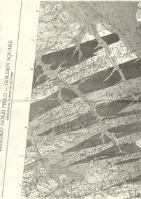
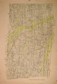
Map - LONG GULLY HISTORY GROUP COLLECTION: BENDIGO GOLD FIELD - GOLDEN SQUARE GEOLOGICAL SURVEY OF VICTORIA
... LONG GULLY HISTORY GROUP COLLECTION: BENDIGO GOLD FIELD - GOLDEN SQUARE GEOLOGICAL SURVEY OF VICTORIA...The Long Gully History Group - Bendigo Gold Field - Golden Square Geological Survey of Victoria...Part of a map of the Bendigo Gold Field - Golden Square. Geological Survey of Victoria. Shown are reefs, faults and anticlines. ...Geological Survey of Victoria. Shown are reefs, faults and anticlines. ...BHS CollectionPart of a map of the Bendigo Gold Field - Golden Square. Geological Survey of Victoria. Shown are reefs, faults and anticlines. Many of the mines are shown on the map. Gullies, hills and streets are also shown.bendigo, history, long gully history group, the long gully history group - bendigo gold field - golden square geological survey of victoria, north bendigo state school reserve, hospital reserve, benevolent asylum reserve, empire hill, richmond hill, raes hill, south end hill, victoria hill, new chum hill, iron bark hill, redan hill, view hill, hustlers hill, camp hill -
 Bendigo Historical Society Inc.
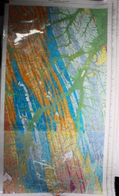
Map - Geological survey of Bendigo Goldfields
... Geological survey of Bendigo Goldfields...Geological Survey...Three Geological survey maps of the Bendigo Gold Fields joined together. ...History House 11 Mackenzie Street Bendigo goldfields Geological Survey Bendigo Gold Fields Three Geological survey maps of the Bendigo Gold Fields joined together. ...Three Geological survey maps of the Bendigo Gold Fields joined together. The three sections are Eaglehawk, Golden Square and Spring Gully. It shows geological conditions, gold reef lines and mine sights. Three sections are laminated together. The maps were produced by the Victorian Department of Manufacturing and Industry Development geological survey, bendigo gold fields -
 Bendigo Historical Society Inc.
Booklet - Bendigo Goldfield, Geological Survey Report No 93
... Bendigo Goldfield, Geological Survey Report No 93......Geological Survey...Soft cover booklet of 50 pages. Geological Survey Report No 93. Bendigo Goldfield. ...Soft cover booklet of 50 pages. Geological Survey Report No 93. Bendigo Goldfield. ...Soft cover booklet of 50 pages. Geological Survey Report No 93. Bendigo Goldfield. Spring Gully, Golden Square, Eaglehawk By C.E. Willman and H.E. Wilkinson. Colour photo of the North Deborah mine poppet-head on a pale-yellow front cover. Illustrated with B&W photos, maps and sketches. Published 1992 by the Department of Manufacturing and Industry Development, Victoria Errata page pasted inside front cover. M & J Qualtrough sticker on title page. bendigo goldfield, geological survey -
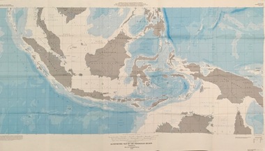 Federation University Historical Collection
Map - Geological, U.S. Government Printing Office, Bathymetric Map of the Indonesian Region: Folio of the Indonesian Region Map I-875-A, 1974, 1974
... ...geological survey...Department of State in cooperation with the Geological Survey of Indonesia. The area covered shows the islands and seas from Latitude 12 degree North to 16 degrees South and Longitude 90 degrees to 148 degrees. ...The U.S. Geological Survey...Various water features are also named. indonesia united nations economic commission department of state geological survey latitude longitude government of indonesia Longitude and Latitude are shown. ...Map was prepared on behalf of the Government of Indonesia, The United Nations Economic Commission for Asia and the Far East, the Agency for International Development and the U.S. Department of State in cooperation with the Geological Survey of Indonesia. The area covered shows the islands and seas from Latitude 12 degree North to 16 degrees South and Longitude 90 degrees to 148 degrees. Various water features are also named.Large map showing the Indonesian area - islands and seasLongitude and Latitude are shown. Major / Capitol cities indicated. Names of those responsible for the productionindonesia, united nations economic commission, department of state, geological survey, latitude, longitude, government of indonesia -
Bendigo Historical Society Inc.
Map - BENDIGO GOLD FIELD LONGITUDINAL VERTICAL PROJECTIONS
... ... geological survey...H.Herman, late Director of Geological Survey....Geological Survey Victoria...H.Herman, late Director of Geological Survey. Map BENDIGO GOLD FIELD LONGITUDINAL VERTICAL PROJECTIONS ...Bendigo gold field map showing vertical projections of portions of three anticlinal axial planes showing stratigraphical zones and caps of known saddle reefs. This map forms part of the Geological Survey of Victoria, Structure of Bendigo Goldfield report, No. 47, 1923. H.Herman, late Director of Geological Survey.Geological Survey Victoriabendigo, gold mining, vertical projections, bendigo, goldfield, gold mining, reef lines, mining companies, geological survey -
Stawell Historical Society Inc
Map, Geological Survey of Victoria
... Geological Survey of Victoria...Geological Survey of Victoria...Stawell Historical Society Inc 46 Longfield St Stawell grampians stawell Geological Survey of Victoria Geological Survey of Victoria Map ...Geological Survey of Victoriastawell -
Sunshine and District Historical Society Incorporated
Map - Geological survey map of Derrimut, Maribyrnong , Kororoit and Jorrk
... Geological survey map of Derrimut, Maribyrnong , Kororoit and Jorrk....Geological survey map of Derrimut, Maribyrnong , Kororoit and Jerk. ...Geological survey map of Derrimut, Maribyrnong , Kororoit and Jerk. ... -
 Federation University Historical Collection
Book, Memoirs of the Geological Survey of Victoria No 14 The Ballarat Goldfields, 1923, 1923
... Memoirs of the Geological Survey of Victoria No 14 The Ballarat Goldfields, 1923...geology...geological survey no 14...Baragwanath was a Councillor of the Ballarat School of Mine from 1916 to 1950. geology geological survey no 14 ballarat baragwanath William Baragwanath Pink covered foolscap book of 257 pages and 32 maps and plans by William Baragwanath. ...William Baragwanath was educated at the Ballarat School of Mines, obtaining a Geology Certificate in 1911. After further study he went on the become Secretary for Mines, and Chief Mining Surveyor. Baragwanath was a Councillor of the Ballarat School of Mine from 1916 to 1950.Pink covered foolscap book of 257 pages and 32 maps and plans by William Baragwanath. Contents include topography, physiography, historical, geology, basalt, faults, dykes, minerals leads, alluvial mines, nuggets, structure of Ballarat West goldfields, structure of Ballarat East gold-field, quartz formation, indicators, defunct mines, existing mines, table of deepest shafts. Images include: section of the Ballarat Gold-Field, Dead HOrse Flat, lakes formed by Basalt Flows, Gong Gong Creek, Frenchman's Lead, Ballarat West Mines, LEases and positions of shafts (1857), puddling, White Horse Lead, Woah Hawp Canton, Ballarat Township mines, Sebastopol, syncline, Victoria United Line, First Chance Mine, Llanberris No 1 Mine, Saddle Reef, New Normanby Mine, Woah Hawp Canton Mine, South Star Mine, Sebastopol Plateau, south Woah Hawp Mine, Woah No. 2 Minegeology, geological survey no 14, ballarat, baragwanath, william baragwanath -
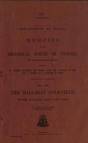 Federation University Historical Collection
Book, William Baragwanath, Memoirs of the Geological Survey of Victoria No 14: The Ballarat Goldfield, 1923, 1923
... Memoirs of the Geological Survey of Victoria No 14: The Ballarat Goldfield, 1923......geological survey of victoria...Memoirs of the Geological Survey of Victoria No 14: The Ballarat Goldfield, 1923 Book Australia Victoria Melbourne William Baragwanath ...257 page foolscap pink covered book relating to the Ballarat goldfields plus 32 plates of maps and sections. william baragwanath, mining, geological survey of victoria, ballarat, goldfields, raglan street, ballarat -
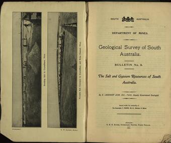 Federation University Historical Collection
Booklet, Geological Survey of South Australia: The Salt and Gypsum Resources of South Australia, 1921
... Geological Survey of South Australia: The Salt and Gypsum Resources of South Australia...geological survey...Geological Survey of South Australia: The Salt and Gypsum Resources of South Australia Booklet ...A South Australian Department of Mines report on salt and gylpsum resources in the state. geological survey, south australia, gypsum, salt, resources, department of mines -
 Federation University Historical Collection
Book, Memoirs of the Geological Survey of Victoria No 11. The Maryborough Goldfield, 1913, 1913
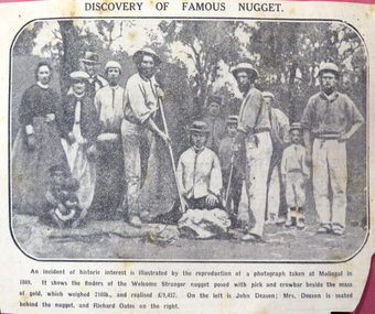
... Memoirs of the Geological Survey of Victoria No 11. The Maryborough Goldfield, 1913...memoirs of the geological survey of victoria...Includes two loose newsclips .2) The Larkinville Nugget (The Age 21 Jan 1931) .3) Discovery of the Welcome Nugget Memoirs of the Geological Survey of Victoria No 11. The Maryborough Goldfield, 1913 Book A.M. ...Pink soft covered book of 76 pages and 7 plates. Includes two loose newsclips .2) The Larkinville Nugget (The Age 21 Jan 1931) .3) Discovery of the Welcome Nuggetmaryborough, memoirs of the geological survey of victoria, d.j. mahony, maryborough goldfield, geology, faults, welcome nugget, richard oates, mrs deason, moliagul, larkinville nugget, m. larcombe, john deason, eucalypts -
Koorie Heritage Trust
Book, Baragwanath, W, Memoirs of the Geological Survey of Victoria : No. 15 The Aberfeldy District, Gippsland, 1925
... Memoirs of the Geological Survey of Victoria : No. 15 The Aberfeldy District, Gippsland...Geology -- Victoria. I. Geological Survey of Victoria. II. Victoria. ...Memoirs of the Geological Survey of Victoria : No. 15 The Aberfeldy District, Gippsland Book Baragwanath, W Dept. of Mines ...15 v. : ill., plates, maps, plans, diagrs. ; 34 cm. lcsh: 1. geology -- victoria -- periodicals. 2. geology -- victoria. i. geological survey of victoria. ii. victoria. dept. of mines. -
Canterbury History Group
Photograph - Geological Survey of Victoria
... Geological Survey of Victoria...Geological Survey of Victoria including Boroondara and Prahran...Geological Survey of Victoria including Boroondara and Prahran Black and white photograph Photograph Geological Survey of Victoria ...Black and white photographgeological survey of victoria including boroondara and prahran -
 Bendigo Historical Society Inc.
Map - STRUGNELL COLLECTION: BENDIGO GOLD FIELD GEOLOGICAL SURVEY, 1936
... STRUGNELL COLLECTION: BENDIGO GOLD FIELD GEOLOGICAL SURVEY...Herman, Director Geological Surveys by H. S. Whitelaw, Field Geologist assisted by E. ...Map STRUGNELL COLLECTION: BENDIGO GOLD FIELD GEOLOGICAL SURVEY ...BHS CollectionBendigo Goldfieds Geological Survey. Prepared in 1923 the Bendigo Office, mines Department under the direction of H. Herman, Director Geological Surveys by H. S. Whitelaw, Field Geologist assisted by E. S. Usher & A. J. J. Moore Re-Issued in 1936 Top Section of original map.Dept of Mines Victoriabendigo, gold mining, geological map, mines department, h. herman, h. s. whitelaw, e. s. usher, a. j. moore -
 Bendigo Historical Society Inc.
Map - STRUGNELL COLLECTION: BENDIGO GOLD FIELD GEOLOGICAL SURVEY, 1936
... STRUGNELL COLLECTION: BENDIGO GOLD FIELD GEOLOGICAL SURVEY...Herman, Director Geological Surveys by H. S. Whitelaw, Field Geologist assisted by E. ...Map STRUGNELL COLLECTION: BENDIGO GOLD FIELD GEOLOGICAL SURVEY ...BHS CollectionBendigo Goldfieds Geological Survey. Prepared in 1923 the Bendigo Office, mines Department under the direction of H. Herman, Director Geological Surveys by H. S. Whitelaw, Field Geologist assisted by E. S. Usher & A. J. J. Moore Re-Issued in 1936 Bottom Section of original map.Dept of Mines Victoriabendigo, gold mining, geological map, h. herman, h. s. whitelaw, e. s. usher, a. j. moore -
 Bendigo Historical Society Inc.
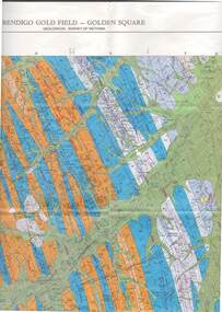
Map - STRUGNELL COLLECTION: GEOLOGICAL SURVEY OF VICTORIA, BENDIGO GOLD FIELD - GOLDEN SQUARE, 1992
... STRUGNELL COLLECTION: GEOLOGICAL SURVEY OF VICTORIA, BENDIGO GOLD FIELD - GOLDEN SQUARE....Map, Geological Survey of Victoria, Bendigo Gold Field - Golden Square, Campaspe 10 000/2.2. ...Map STRUGNELL COLLECTION: GEOLOGICAL SURVEY OF VICTORIA, BENDIGO GOLD FIELD - GOLDEN SQUARE. ...Map, Geological Survey of Victoria, Bendigo Gold Field - Golden Square, Campaspe 10 000/2.2. Victoria 10,000.Dept. 0f Manufacturinf & Industry Development.map, bendigo, golden square gold field -
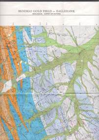 Bendigo Historical Society Inc.
Map - STRUGNELL COLLECTION: GEOLOGICAL SURVEY OF VICTORIA, BENDIGO GOLD FIELD - EAGLEHAWK, 1992
... STRUGNELL COLLECTION: GEOLOGICAL SURVEY OF VICTORIA, BENDIGO GOLD FIELD - EAGLEHAWK...Map, Geological Survey of Victoria, Bendigo Gold Field - Eaglehawk.Campaspe10 000/2.3; Victoria 1:10,000. ...Map STRUGNELL COLLECTION: GEOLOGICAL SURVEY OF VICTORIA, BENDIGO GOLD FIELD - EAGLEHAWK ...Map, Geological Survey of Victoria, Bendigo Gold Field - Eaglehawk.Campaspe10 000/2.3; Victoria 1:10,000. Index of Shafts.Dept. of Manufacturing & Industry Developmentmap, bendigo, eaglehawk gold field -
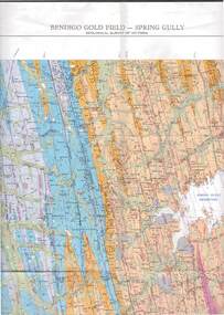 Bendigo Historical Society Inc.
Map - STRUGNELL COLLECTION: GEOLOGICAL SURVEY OF VICTORIA, BENDIGO GOLD FIELD - SPRING GULLY, 1987
... STRUGNELL COLLECTION: GEOLOGICAL SURVEY OF VICTORIA, BENDIGO GOLD FIELD - SPRING GULLY....Map, Geological Survey of Victoria, Bendigo Gold Field - Spring Gully, Campaspe 10 000 2/1; Victoria 10,000....Map STRUGNELL COLLECTION: GEOLOGICAL SURVEY OF VICTORIA, BENDIGO GOLD FIELD - SPRING GULLY. ...Map, Geological Survey of Victoria, Bendigo Gold Field - Spring Gully, Campaspe 10 000 2/1; Victoria 10,000.Cept. Of Industry, Technology & Resources.map, bendigo, spring gully gold field -
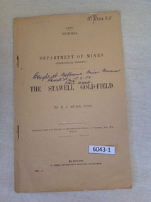 Stawell Historical Society Inc
Book, E.J. Dunn, Department of Mines Geological Survey The Stawell Gold Field - Previously Cat No 3643-1, 1909
... Department of Mines Geological Survey The Stawell Gold Field - Previously Cat No 3643-1...1909 Victoria Department of mines (Geological Survey) {in Ink} Brought at Melbourne Mines Museum, Russell St 7.3.78. ...Dunn F.G.S Replicated from the Records of the Geological Survey of Victoria, Vol III. Part 1. By Authority J. ...A short Geological analysis of the Stawell Gold FieldsFawn Paper cover with two staples along spine1909 Victoria Department of mines (Geological Survey) {in Ink} Brought at Melbourne Mines Museum, Russell St 7.3.78. Ron Wood} The Stawell Gold Field By E.J. Dunn F.G.S Replicated from the Records of the Geological Survey of Victoria, Vol III. Part 1. By Authority J. Kemp, Government Printer, Melbourne. 7290 -2stawell mining -
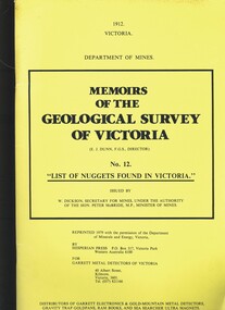 Bendigo Historical Society Inc.
Book - MEMOIRS OF THE GEOLOGICAL SURVEY OF VICTORIA NO.12. LIST OF NUGGETS FOUND IN VICTORIA
... MEMOIRS OF THE GEOLOGICAL SURVEY OF VICTORIA NO.12. LIST OF NUGGETS FOUND IN VICTORIA....Memoirs Of The Geological Survey Of Victoria No.12. List Of Nuggets Found In Victoria. ...Book MEMOIRS OF THE GEOLOGICAL SURVEY OF VICTORIA NO.12. LIST OF NUGGETS FOUND IN VICTORIA. ...Memoirs Of The Geological Survey Of Victoria No.12. List Of Nuggets Found In Victoria. Issued by Department of Mines, 69 pages in yellow soft cover.Department of Minesvictoria, history, mining