Showing 10 items matching " harbour trust jetty"
-
 Glenelg Shire Council Cultural Collection
Plan - Line drawing Portland Harbour Trust Marina jetty, mooring and fendering details, 29/09/1972
... Line drawing Portland Harbour Trust Marina jetty, mooring and fendering details...Line drawing Portland Harbour Trust Marina jetty, mooring and fendering details. ...Scale 1":10'0" Drawing no. 3679 Plan Line drawing Portland Harbour Trust Marina jetty, mooring and fendering details ...Front: '46' - black texta, top right cornerport of portland -
Glenelg Shire Council Cultural Collection
Photograph - Photograph - Main Breakwater Construction, n.d
... ... Harbour trust jetty...Coloured photograph of trawler 'Halcyon' and several other fishing vessels moored at Harbour trust jetty....Glenelg Shire Council Cultural Collection History House Cliff Street Portland great-ocean-road Port of Portland Authority Archives Port of Portland Archives Portland Harbour trawler Halcyon Fishing Vessels Moored Harbour trust jetty Coloured photograph of trawler 'Halcyon' and several other fishing vessels moored at Harbour trust jetty. ...Port of Portland Authority Archivesport of portland archives, portland harbour, trawler, halcyon, fishing vessels, moored, harbour trust jetty -
Glenelg Shire Council Cultural Collection
Photograph - Photograph - Main Breakwater construction, Portland, n.d
... Coloured photo of several yachts moored at the Harbour Trust jetty....Glenelg Shire Council Cultural Collection History House Cliff Street Portland great-ocean-road Port of Portland Authority Archives Port of Portland Archives harbour construction Portland Harbour Trust Coloured photo of several yachts moored at the Harbour Trust jetty. ...Port of Portland Authority Archivesport of portland archives, harbour construction, portland harbour trust -
Glenelg Shire Council Cultural Collection
Photograph - Photograph - Portland Harbour, n.d
... Coloured photograph of trawler on large slipway at Harbour Trust. Small vessel moored at jetty....Glenelg Shire Council Cultural Collection History House Cliff Street Portland great-ocean-road Port of Portland Authority Archives Port of Portland Archives harbour construction trawler Harbour Trust Coloured photograph of trawler on large slipway at Harbour Trust. Small vessel moored at jetty. ...Port of Portland Authority Archivesport of portland archives, harbour construction, trawler, harbour trust -
 Glenelg Shire Council Cultural Collection
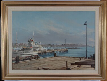
Painting, Whalers Point from Harbour Trust Dock, n.d
... harbour and jetties from a dock. Dock is in foreground. A white fishing vessel is berthed at a jetty positioned near the dock. In background is a view of the foreshore with buildings. The water is pale blue with darker blue details. The sky is blue with grey wash depicting clouds near horizon line. Mounted in thick cream canvas mount, framed under glass in wooden gold painted frame. Whalers Point from Harbour Trust ...Port of Portland CollectionView of harbour and jetties from a dock. Dock is in foreground. A white fishing vessel is berthed at a jetty positioned near the dock. In background is a view of the foreshore with buildings. The water is pale blue with darker blue details. The sky is blue with grey wash depicting clouds near horizon line. Mounted in thick cream canvas mount, framed under glass in wooden gold painted frame.Front: Signature - Ramon Horsfield (lower left) (orange paint). Back: (no inscription)port of portland -
 Flagstaff Hill Maritime Museum and Village
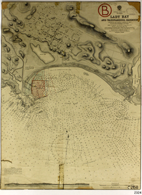
Document - Navigation Chart, Admiralty Office, Lady Bay and Warrnambool Harbour, 1893
... Harbour...Port of Warrnambool...Breakwater...Jetty...Pier...Dock extension...proposed extension...VHR H2024...1870...1893...1910...1925...Warrnambool town late 1800s...Warrnambool streets late 1800s Royal Commission...1923...Public Works...Water Commission...Harbour Trust...harbour engineer, Sir John Coode. The chart is a historical record of structures existing in 1893; the Warrnambool Jetties, Warrnambool Breakwater in Lady Bay, the leading lights (lighthouses), streets, roads, bridges and many buildings. It also shows the lay of the land and seabed. Flagstaff Hill Warrnambool Flagstaff Hill Maritime Museum & Village Maritime Museum Maritime Village shipwreck coast Map chart Navigation chart plan Lady Bay Warrnambool Harbour Port of Warrnambool Breakwater Jetty Pier Dock extension proposed extension VHR H2024 1870 1893 1910 1925 Warrnambool town late 1800s Warrnambool streets late 1800s Royal Commission 1923 Public Works Water Commission Harbour Trust Victorian Harbours Sir Jon Coode Stamp, rectangular, including "AUG 1910" Stamp, double oval " - - - -CHART" Stamp, hand drawn, red circle, with "B" inside Hand written note "22-8-1910 - - - - - of surveying C. ...This navigation cart of Lady Bay and Warrnambool Harbour was originally surveyed in 1870 but this version includes the update for magnetic variation in 1893. Since the printing of the chart several annotations have been added. These include an additional stamp dated 15-8-1910, a handwritten comment across the top of the page dated August 1910, and another handwritten comment regarding the ‘Proposed Extension of Dock’ dated 19-2-1925, plus connected drawings, notes and figures. The 1925 proposal on this chart may have been a reaction to the Royal Commission of 1923, when the damaged stonework on the seaward side of the Warrnambool Breakwater, caused by the action of the sea, was the subject of enquiry. A conference between the Public Works, Water Commission and the Harbour Trust concluded that it would less costly to make repairs to prevent further damage rather than replaced the damage portion of the wall. A contract was raised in late 1924 to deposit rubble on the damaged side of the breakwater to minimise the Southern Ocean’s destructive action and work had started by August 1925. The Breakwater construction had begun in 1874 and was completed in 1890. The Victorian Government had commissioned Sir John Coode, a British harbour engineer, to present a plan to complete the Warrnambool Breakwater but his original plan was too expensive. He prepared a revised plan for a shorter structure. The construction proved to be too short to protect adequately from the weather and didn't allow enough depth for larger vessels to come into port. The decreasing trade was further affected by siltation in the bay due to the breakwater, and the completion of the railway line. The situation of the harbour became a real problem by 1910 and required continuous dredging. In 1914 the Breakwater was extended but proved to be a failure because the work began to subside and by 1920 about two thirds of the harbour was silted up. Alterations made in the 1920's increased the silting problem and by the 1940's the harbour was no longer used. More alterations were made in the 1950's and 1960's. This chart is significant for its strong connection to the maritime history of Warrnambool Harbour and Lady Bay and the Warrnambool Breakwater. The Warrnambool Breakwater is registered as a place of significance on the Victorian Heritage Database (VHR H2024). The Warrnambool Breakwater is one of the most important late 19th century maritime engineering projects in Victoria and significant in the development of Victorian coastal shipping. It is also significant for its connection with British harbour engineer, Sir John Coode. The chart is a historical record of structures existing in 1893; the Warrnambool Jetties, Warrnambool Breakwater in Lady Bay, the leading lights (lighthouses), streets, roads, bridges and many buildings. It also shows the lay of the land and seabed. Navigation Chart: Lady Bay and Warrnambool Harbour, Australia - South Coast - Victoria. Surveyed by Nav. Lieut. H.J. Stanley, R.N., 1870. Updated for Magnetic Variation, 1893. The rectangular chart is printed on heavy cream paper. Stamps are shaped rectangular, oval and round. Around the Breakwater and Jetty area are handwritten notes, dotted and joined lines, numbers and signatures, and shading of red and green. The chart shows the surrounds of Warrnambool Harbour, Lady Bay, the Breakwater and Jetty, roads, bridges and the streets in Warrnambool. It has sounding details, and angles of line from the leading lights.Stamp, rectangular, including "AUG 1910" Stamp, double oval " - - - -CHART" Stamp, hand drawn, red circle, with "B" inside Hand written note "22-8-1910 - - - - - of surveying C. Ca - - - request of 15-8-10 [initials] " Notes and lines in red pen, including a grid of sounding numbers: "1300" "1050" "1200" "Possible Extension of Dock" "19-2-25" "Dock Dredged to 20 Ft" Notes and lines in blue pen "Extension of Dock to accommodate vessels drawing 20 Feet" and "Light not visible south of this line" Red dots (4) with yellow highlight at both leading lights, breakwater and jettyflagstaff hill, warrnambool, flagstaff hill maritime museum & village, maritime museum, maritime village, shipwreck coast, map, chart, navigation chart, plan, lady bay, warrnambool harbour, port of warrnambool, breakwater, jetty, pier, dock extension, proposed extension, vhr h2024, 1870, 1893, 1910, 1925, warrnambool town late 1800s, warrnambool streets late 1800s royal commission, 1923, public works, water commission, harbour trust, victorian harbours, sir jon coode -
 Flagstaff Hill Maritime Museum and Village
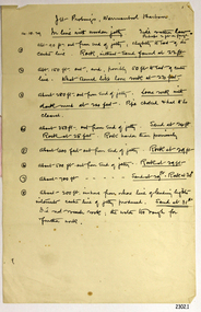
Document - Report, Jet Probings, Warrnambool Harbour, 16-10-1929
... harbour...1929...soundings...jet probe...jet probing...seabed...map of seabed...underwater engineering...warrnambool jetty...warrnambool breakwater...breakwater upgrade...leading lights...chart the harbour...Flagstaff Hill...Warrnambool...Flagstaff Hill Maritime Museum & Village...Maritime Museum...Maritime Village...shipwreck coast...Lady Bay...Port of Warrnambool...Breakwater...Jetty...Pier...VHR H2024...Royal Commission...1923...Public Works...Water Commission...Harbour Trust...The results could determine plans for future engineering works. document depth warrnambool harbour 1929 soundings jet probe jet probing seabed map of seabed underwater engineering warrnambool jetty warrnambool breakwater breakwater upgrade leading lights chart the harbour Flagstaff Hill Warrnambool Flagstaff Hill Maritime Museum & Village Maritime Museum Maritime Village shipwreck coast Lady Bay Port of Warrnambool Breakwater Jetty Pier VHR H2024 Royal Commission 1923 Public Works Water Commission Harbour Trust Victorian Harbours Report, titled 'Jet Probings, Warrnambool Harbour'. ...This report lists the depths of water and the consistency of the seabed surrounding the Warrnambool Harbour in October 1929, The information, often referred to as 'soundings', was obtained by Jet Probing,. In earlier days a lead line was used to perform a similar task. The author of the document is unknown. Jet Probing is a method used for underwater archaeology, cable installation and coastal engineering. A jet probe is a machine that produces a strong jet of water that penetrates the layers of sediment on the seabed, determining their depth, thickness and consistency. It provides a survey of the seabed and can be used as an aid to engineering design and construction. The report mentions lining up with the wooden jetty, the end of the breakwater and the leading lights. It mentions sand, loose rock and rock. It tells of stopping work due to the water being too rough, the pipe choking, difficulty in connecting pipes, and pipe joint breaking as it tried to get through the sand, The report in the document is significant for its connection with the Warrnambool Harbour, Warrnambool Breakwater, Warrnambool Jetty and Lady Bay. The report gives figures for the depth and consistency of the water and seabed at a particular point in time and can be used to compart with similar figures taken at different times. The results could determine plans for future engineering works.Report, titled 'Jet Probings, Warrnambool Harbour'. Two pages of cream coloured paper with hand written notes in pen and ink. Report covers three days of Jet Probings, with resulting figures and comments, for the depths of the surroundings of the Warrnambool Harbour. The report is in point form, with some underlining. Dates of recordings are 14-10-29, 15-10-29 and 16-10-29. (1929) The situation of the harbour had become a real problem by 1910 and required continuous dredging. In 1914 the Breakwater was extended but proved to be a failure because the work began to subside and by 1920 about two thirds of the harbour was silted up. Alterations made in the 1920's increased the silting problem. The soundings and Jet Probings were done after the Royal Commission of 1923, when the damaged stonework on the seaward side of the Warrnambool Breakwater, caused by the action of the sea, was the subject of enquiry. A conference between the Public Works, Water Commission and the Harbour Trust concluded that it would less costly to make repairs to prevent further damage rather than replaced the damage portion of the wall. A contract was raised in late 1924 to deposit rubble on the damaged side of the breakwater to minimise the Southern Ocean’s destructive action and work had started by August 1925. By the 1940's the harbour was no longer used. More alterations were made in the 1950's and 1960's. document, depth, warrnambool harbour, 1929, soundings, jet probe, jet probing, seabed, map of seabed, underwater engineering, warrnambool jetty, warrnambool breakwater, breakwater upgrade, leading lights, chart the harbour, flagstaff hill, warrnambool, flagstaff hill maritime museum & village, maritime museum, maritime village, shipwreck coast, lady bay, port of warrnambool, breakwater, jetty, pier, vhr h2024, royal commission, 1923, public works, water commission, harbour trust, victorian harbours -
 Flagstaff Hill Maritime Museum and Village
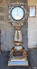
Instrument - Scale, Weighing Machine, G. Salter & Co, 1884-1909
... In 1928, the Sydney Harbour Trust gave the firm the right to place the weighing machines on various ferry jetties. ...In 1928, the Sydney Harbour Trust gave the firm the right to place the weighing machines on various ferry jetties. ...This ornate, Victorian-era automatic weighing machine was made in England around 1884-1909, by George Salter and Co. of West Bromwich, UK, makers of scales since 1760. It is protected by Queen Victoria’s Royal Letters Patent, signed in 1900. The scale stood outside the Warrnambool Post Office in Timor Street from around 1909 to 1966, as shown on postcards and photographs held at the State Library of Victoria. The scale is identified by the Serial Number '665', and was installed by the distributors, the Australasian Automatic Weighing Machine Co. Ltd.. The scale’s weight measurements were in Imperial stones and pounds up to 20 stone (127 kg). The scale’s face included charts of average weights, for men, women, boys and girls, by various heights, in feet and inches. The coin slot and its face were converted to metric measurements by the Eastern Scale Company Pty. Ltd; that firm was registered on October 2, 1974. The Australasian Automatic Weighing Machine Co. Ltd was a large supplier of weighing scales in Australia and held the Royal Letters patent for their machines, distributing them in prominent locations. In 1902, the firm was listed under the Import Entries Passed at His Majesty’s Customs, importing into Sydney, NSW, eight cases of scales. In 1911, the company asked permission from the Port Pirie Corporation to install a machine in Alexander Street. In 1913, the company applied to the City of Sydney to install machines around the city, including at the tram depot. One application mentions “… three machines in three places for three pounds per year”. In 1923, the firm tendered for the right to place Automatic Weighing Machines on railway and tram premises throughout New South Wales, subsequently for five-year terms, in return for a fixed payment per machine and a portion of the revenue to the NSW Government. In 1928, the Sydney Harbour Trust gave the firm the right to place the weighing machines on various ferry jetties. The firm was still operating in 1941, advertising for two boys aged 14-16 for the workshop and messages, at the Rialto building, 497 Collins St., Melbourne. On December 21, 1946, the Commonwealth government invited offers to tender for the right to place automatic weighing machines on postal premises throughout the six states; the successful company then made arrangements with the federal Postmaster General's Department to place machines outside post offices across the country. A few years later, on September 11, 1950, the firm's Adelaide branch ceased trading. From 11th July 1950, the Australian and Eastern Engineering Company Pty. Ltd took over at the same premises, at 179 Pirie Street, Adelaide. The Perth branch ceased business in WA on July 6th, 1950. Percival Everitt invented and patented the automatic, coin-operated personal scale design. Everitt was a Norfolk-born engineer and regarded as the father of the coin-operated industry. As a young man in 1877, he invented a hay and corn pitcher, a turnip thinner in 1878 and an Automatic Travelling Anchor in 1880. But his fame came in 1883 with the first postcard-vending machine, over a hundred of which he distributed around London. In 1884, he patented one of his many inventions, the coin-operated scales for use in public places; for many people, it was their first exposure to coin-operated machines. His success prompted the formation of the Weighing Machine Company in 1885. Further inventions followed: a blow tester in 1887, the machine for testing a person's grip in 1888, and in 1889, the dispensing machine for hiring out opera glasses, and a device for shutting down the coin entry slot if the machine was empty. In 1890, he invented a fortune-telling machine. Everitt sadly did not make his fortune; he died suddenly in February 1893, in his late forties, with £71 to his name. George Salter & Co., West Bromwich, England, produced automatic weighing scale machines from Everitt’s patented design, and advertised them as suitable for hotels, pleasure gardens, theatres, exhibition halls, clubs, baths and places of public resort. The company was established in 1760 by brothers Richard and William Salter, and manufactured springs and pocket steelyards (spring balances). After several generations, the company was taken over in 1855 by a nephew, George, and renamed George Salter & Co. In 1884, Salter registered the trademark of a Staffordshire knot pierced by an arrow. The company's expanded range of products included the first coin-operated public weighing machines in the 1880s and, in 1895, the first English-made typewriter. In 1915, Salter became a limited company, Geo. Salter & Co. Ltd. When the last George Salter died in 1917, the company passed into the hands of other relatives, but continued to grow before being bought out by Staveley Industries in 1973. Despite several subsequent mergers, the Salter name continues to be seen on household products such as digital scales. This patented, coin-operated weight machine is significant for its association with Percival Everitt, the inventor of the world’s first slot machine, with the renowned maker of scales, G. Salter & Co., which began operating in 1760, and also with the Australasian Automatic Weighing Scale Co., which imported and widely distributed the scales throughout Australia from the early-to-mid 20th century. It is a rare example of an early vending machine used in public places from the late 19th through to the mid-20th century. These machines were the early step in the evolution of coin-in-the-slot machines, which are still used today. The scales give a glimpse into our history; they became quickly popular with the public, which, until then, had little access to weight scales apart from those at medical services. They also provided inexpensive entertainment for families, especially while waiting for trains or visiting the post office. The machines were also attractive and lucrative to the distributors; once installed, they required very little maintenance, and their low cost to customers kept the money coming in. This automatic weighing machine is also significant for its decades of service to the local and regional community of Warrnambool, for personal and commercial purposes. A public coin-operated weighing scale, also called a penny scale. It is a large, silver-painted cast metal stand with a square top on a pedestal that flares outwards to join a rectangular platform base with posts on the side and corners that may have had fitted wheels. The round, white face on top has red and black measurements and inscriptions. A slim indicator with a point at one end and an arc at the other is attached to the face’s centre. The coin slot is above the face, on the left, and the scale’s identification number is engraved on an oval plate on the right. Moulded motifs decorate the pedestal’s front and are repeated on its sides; they depict a tall, narrow urn with a bowl on top and fancy scrolls on either side. There is a decorative panel across the front top of the stand. The top of the pedestal has a small keyhole. The size of the coin slot fitted a penny coin, and the weight measurements on the face were in Imperial stones and pounds. Quite some time after 1966, when Australia introduced new decimal weights, measurements and currency, the scale was updated; the coin slot size was changed, and a new face with metric measurements was installed. The scale now accepts a $1 coin (one dollar) and the scale measures weight in kilograms and grams, from 0 to 125 kg.. The rear of the scale has a small, rectangular metal plate with printed text. The scale was made by G Salter & Co. of West Bromwich, UK, distributed by the Australasian Automatic Weighing Platform Co., and updated to metric measurements by Eastern Scale Co. Pty Ltd. It was previously installed at the Warrnambool Post Office. Engraved on an oval plate on the right: "665" Top centre of the face, in red: "$1 coin" Top of face: "EASTERN SCALE CO. PTY LTD" Base of face, in red: "[Royal Coat of Arms of Britain]" with words, below in red: "BY ROYAL LETTERS PATENT" Around the face, in black: "[numbers 0 to 125, in increments 5, and makes between the numbers for each 500g]" "kg" Below the face, moulded letters within a shield: "AUSTRALASIAN AUTOMATIC WEIGHING MACHINES CO. LTD." At the back of the weighing platform: "G SALTER & CO. / WEST BROMWICH", remnants of logo “[Staffordshire knot pierced by an arrow]” Plate on rear: THIS SCALE REMAINS THE PROPERTY OF EASTERN SCALE CO. PTY. LTD., 8 GEORGE COURT, GREENSBOROUGH, VIC, 3088. PHONE (03 ) _ 34 _ _ 33” (434 9333 ?_flagstaff hill, warrnambool, maritime village, maritime museum, flagstaff hill maritime museum and village, shipwreck coast, great ocean road, scale, weighing scale, salter, australasian, 1 dollar, $1 coin, 1p, 1 penny coin, penny scale, coin in slot scale, eastern scale co. pty. ltd., british royal coat of arms, royal letters patent, letters patent, health, ending machine, coin-operated machine, percival everett, weighing machine co., george salter & co., g salter & co, west bromwich, vending machine, weights & balances, measurements, slot machine, coin operated machine, penny-in-the-slot, coin fed, coin op scale, weights & measures, australasian automatic weighing machine co. ltd., warrnambool post office, machine 665, no. 665, blalnce technology, scales and weights, weights and measures, penny weight scales, vintage, weighing machine, coin in the slot, coin operated, public scale, public weighing machine, penny-weighing machines, penny weighing machines, penny scales, coin operated weighing machine, scale weighing machine -
 Flagstaff Hill Maritime Museum and Village
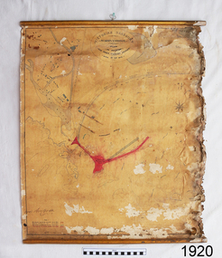
Document - Plan, Victorian Harbours Warrnambool, Victorian Harbours, Warrnambool, Plan to Accompany Sir John Coode's Report, 28-02-1879
... jetties at the Port of Warrnambool, plus the partially erected Breakwater and proposed works to the Breakwater by both the Borough of Warrnambool Surveyor and Sir John Coode. The plan was signed 28th February 1879 by Sir John Coode. The legend at the bottom left describes the existing works and the proposed works. The Warrnambool Breakwater Sir John Coode was a British harbour engineer. He was brought to Melbourne by the Melbourne Harbour Trust...jetties at the Port of Warrnambool, plus the partially erected Breakwater and proposed works to the Breakwater by both the Borough of Warrnambool Surveyor and Sir John Coode. The plan was signed 28th February 1879 by Sir John Coode. The legend at the bottom left describes the existing works and the proposed works. The Warrnambool Breakwater Sir John Coode was a British harbour engineer. He was brought to Melbourne by the Melbourne Harbour Trust ...This plan is of great significance to the local history of Warrnambool, in particular the Breakwater and its impact on Warrnambool's maritime and trade history. The plan shows the existing jetties at the Port of Warrnambool, plus the partially erected Breakwater and proposed works to the Breakwater by both the Borough of Warrnambool Surveyor and Sir John Coode. The plan was signed 28th February 1879 by Sir John Coode. The legend at the bottom left describes the existing works and the proposed works. The Warrnambool Breakwater Sir John Coode was a British harbour engineer. He was brought to Melbourne by the Melbourne Harbour Trust to advise on works to improve the Port of Melbourne. The Victorian Government commissioned him to present a plan to complete the Warrnambool Breakwater. His original plan was too expensive so he prepared a revised plan for a shorter structure. The work was completed in 1890. The construction proved to be too short to protect adequately from the weather and didn't allow enough depth for larger vessels to come into port. The decreasing trade was further affected by siltation in the bay due to the breakwater, and the completion of the railway line. The situation of the harbour became a real problem that, by 1910, required continuous dredging. In 1914 the Breakwater was extended but proved to be a failure because the work began to subside and by 1920 about two thirds of the harbour was silted up. Alterations made in the 1920's increased the silting problem and by the 1940's the harbour was no longer used. More alterations were made in the 1950's and 1960's. The Warrnambool Breakwater is registered as a place of significance on the Victorian Heritage Database. This plan of the proposed works for the existing Warrnambool Breakwater is of great significance to the local history of Warrnambool, in particular the Breakwater and its impact on Warrnambool's maritime and trade history. The Warrnambool Breakwater is registered as a place of significance on the Victorian Heritage Database (VHR H2024). It is historically significant to Victoria as one of the most important maritime engineering projects in Victoria in the late 19th century. The Warrnambool Breakwater is of historical significance as one of the most important maritime engineering projects in Victoria in the late nineteenth century. It is evidence of Victoria's nineteenth century investment in regional port infrastructure and the development of Victorian coastal shipping. It is of significance for its association with the English civil engineer Sir John Coode, the most distinguished harbour engineer of the nineteenth century, who was brought to Victoria to advise on works to improve the Port of Melbourne, but was retained by the Government to advise on improvements to the harbours at Portland, Geelong, Port Fairy, and Lakes Entrance, as well as Warrnambool. His projects for Melbourne, Lakes Entrance and Warrnambool were major engineering projects of the nineteenth century. The breakwater is historically significant as a reminder of Warrnambool's early maritime history as a Western District port, and as one of Victoria's major 'outer ports'. While the Warrnambool Breakwater is a demonstration of the engineering skills of the nineteenth century, it also demonstrates the limitations of knowledge relating to sedimentology at the time and the confidence apparent in a number of nineteenth century plans which assumed that natural forces could be overcome or contained by engineering.Plan of Warrnambool Harbour, Port of Warrnambool, dated 28 Feb 1879. Plan shows existing Breakwater and work proposed by both Warrnambool Borough Surveyor and Sir John Coode. Plan has gold coloured quarter-dowel rods top and bottom and a metal ring at the top. Stamped with title. Signed by Sir John Coode.Stamped "VICTORIAN HARBOURS / WARRNAMBOOL / PLAN / to accompany / SIR JOHN GOODE'S REPORT / DATED 28 FEB 1879" Signature "John Coode"flagstaff hill, warrnambool, maritime museum, shipwreck coast, great ocean road, sir john coode, borough of warrnambool surveyor, plan of warrnambool, victorian harbours, warrnambool harbour, warrnambool breakwater, port of warrnambool, vhd vhr h2024, flagstaff hill maritime museum & village, maritime village, map, chart, plan, lady bay, breakwater, jetty, pier, vhr h2024, proposed works, 1879 -
 City of Melbourne Libraries
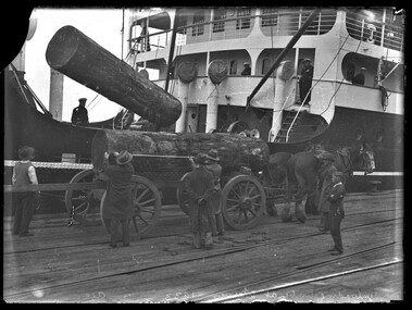
Photograph (item), Bull, Hugh Jones, 1897-1993, Unloading timber at Victoria Dock, 1933
... Harbour Trust Commissioners had decided that land in or near the city was far too valuable to be used as timber yards. Furthermore, large stacks of timber posed a fire risk. The Trust asked the Victorian Government to reserve a site on the east side of the Yarra River opposite Yarraville and Spotswood. Here, in 1889, the Trust began building six jetties...Harbour Trust Commissioners had decided that land in or near the city was far too valuable to be used as timber yards. Furthermore, large stacks of timber posed a fire risk. The Trust asked the Victorian Government to reserve a site on the east side of the Yarra River opposite Yarraville and Spotswood. Here, in 1889, the Trust began building six jetties ...Photographer notations on slide: "Unloading Timber at Wharves 1933 Age B5" Published: Age (Melbourne, Vic.: 1854- ), Tuesday 15 August 1933 MAHOGANY FROM MANILA. (1933, August 15). The Age (Melbourne, Vic. : 1854 - 1954), p. 11. Retrieved January 16, 2026, from http://nla.gov.au/nla.news-article204377024 Published title: MAHOGANY FROM MANILA Published Caption: Age Tue 15 Aug 1933 Caption: Unloading Mahogany Logs brought from Manila, Philippine Islands, by the steamer Taiping, which berthed yesterday at Victoria Dock. The vessel discharged twenty logs, each weighing three tons, the first shipment of this type of timber landed in Melbourne. Research by Project Volunteer, Louise McKenzie: This photograph in many ways epitomises Melbourne in the 1930s. It is a time of enormous growth, development and change. But before delving into that, the photo itself is very powerful. The huge mahogany logs being unloaded appear to be so heavy that the ship itself seems to list to port as they are craned over the side. They are being levered into a cart to which two large and sturdy Clydesdale horses are hitched. In contrast to the traditional horses, the wharf is crisscrossed with modern railway tracks. Unloading is both mechanical and manual, and the scene is one of intense interest to a young boy bystander. The ship appears to be squat and solid, but the whole image also gives a feeling of movement and intensity. The mahogany being delivered to Melbourne would be intended for high quality furniture. In the 1930s Australia actually had a growing timber industry, but much of the eucalyptus wood was being utilised for mass produced furniture, and much of this furniture would then have had a veneer applied to it. The fact that it was economic to import this timber from the “Philippine Islands” – not a traditional trading market for Australia – reflects a Victorian economy that was strong enough to support a growing demand for good quality furniture Mahogany was described as a classic, strong hardwood, often used for dark opulent furniture. In the 1930s the importation of timber from Manila (Philippines) to Australia was a notable trade, particularly in Philippine Lauan (often referred to as Philippine Mahogany), which was used as a cheaper alternative to other hardwoods. 1930s furniture, dominated by the art deco style, used a mix of luxurious exotic woods like mahogany, macassar and ebony for high-end pieces, often veneered over less expensive woods such as walnut, birch and poplar, and with plywood, chrome and lacquer also popular for more practical, streamlined designs during the Depression era. By the mid 1930s timber mills were being relocated away from the immediate dock area, but the fact that these logs were being transported by horse-drawn cart implies that the load would not have had to be taken too far for milling. 1885 the Melbourne Harbour Trust Commissioners had decided that land in or near the city was far too valuable to be used as timber yards. Furthermore, large stacks of timber posed a fire risk. The Trust asked the Victorian Government to reserve a site on the east side of the Yarra River opposite Yarraville and Spotswood. Here, in 1889, the Trust began building six jetties and a wharf specifically for the landing of timber. Clydesdale horses were initially brought to Victoria from Tasmania in the 1830s, and with the 1850s gold rush they were imported direct from Scotland. Melbourne was from its earliest years an important centre of horse-breeding from both imported and colonial-bred stock, providing the well-built draught horse for pulling heavily loaded wagons, the harness horse for delivery work and drawing coaches, and the saddle-horse used for riding. Stud breeding facilities were advertised from the early 1840s. By the 1870s the horse export trade was thriving, and the Port of Melbourne was the country's busiest exporter of horses to Indian, Asian and New Zealand markets. Kirk's Melbourne Horse and Carriage Bazaar in Bourke Street first advertised for business in 1840, and by the 1850s Bourke Street West was famed for its horse bazaars and saleyards. The Victorian Clydesdale Horse Society reports that Clydesdale working horses were a vital part of Melbourne's infrastructure and agricultural industry in the 1930s, when they reached the peak of their popularity despite the increasing competition from mechanization. Their main roles and usage at this time were: • City Delivery: Clydesdales were a common sight for metropolitan deliveries, particularly for breweries (such as Carlton & United Breweries), milk runs, and bread deliveries. • Industrial Work: They were heavily used for hauling cargo at the docks, in construction, and at specialized sites like the Truganina Explosives Reserve, where they pulled wagons. • Agriculture: In surrounding rural areas, they were the primary power source for ploughing and agricultural machinery. • Specialization: By the 1930s, the Clydesdale was smaller and more compact than the Shire or Percheron breeds, making them ideal for navigation in urban environments. After the 1930s their numbers decreased due to the onset of WWI and mechanisation. Wartime petrol rationing led to a brief revival for the working horse, as suburban tradesmen, now used to motor delivery, took their old jinkers out of mothballs. By 1947, however, only 1.5% of city traffic was horse-drawn. In 1952 the large horse cartage company A. Kellet Pty Ltd sold its 250 horses and converted its Richmond stables to storage. In the 1950s at Station and Princes piers, wharf labourers refused to work with the six draught horses still being used to haul trolleys and which were soon superseded by the fork lift, semi-trailer and mobile crane. Where carefully trained horses had once shunted trains in city goods yards, a few hundred a week were now being killed at the abattoirs for pet and human consumption. The last MCC dray horse was withdrawn from service in 1958, but some of the few remaining working animals are used by the mounted police for crowd control at demonstrations and football games. The death knell had also sounded for the associated trades of farrier, saddler and blacksmith. Our photo, therefore, showing the wharf with both the haulage Clydesdales and the rail lines, is a strong visual summary of the social and economic changes experienced in Victoria in the 1930s and on towards the 1950s. Our photo is located at Victoria Dock (also known as Victoria Harbour) which is still an active component of Melbourne’s port system. In 1892 the West Melbourne Dock (later Victoria Dock) was opened, downstream and immediately west of the Spencer Street railway shunting yards. It contained a swing basin for ships, replacing the one which had been provided on the south side of the river, later to be the Duke and Orr dry dock, west of the Charles Grimes Bridge. Further west was the South Wharf along the river bank. The history of Victoria Dock is extremely well described by Ashley Smith in his 2 March 2022 article in Docklands News, and its accompanying aerial photo of the Dock taken in 1934. He writes: "In the early 1930s Victoria Dock was one of the biggest sites for trade and export in Melbourne. A constant queue of ships sailed in, unloaded their cargo, recharged and reloaded, then left for the next port. Around the time this photo was taken (found in a 1934 photo book), the trapezium-shaped basin had been through some changes since its construction in the 1890s. The 497-metre-long Central Pier, finished in 1919, now featured six sheds to house the ever-increasing volume of cargo. The entrance had also been widened in the 1920s to allow better access. Some of the berths featured three-ton jib electric cranes to help with loading cargo and a rail network connected to the State Railway service. By the time construction was completed, the dock was 39 hectares and hailed as the second-largest dock in the world (behind Cavendish Dock, Barrow-in-Furness). To further save costs, excavations were dug to a more reasonable seven metres below low water, instead of British engineer Sir John Coode’s recommended 8.3 metres. Even then, the costs were still around £900,000. It was envisaged, with the extra wharfage, that around thirty 90-metre ships could berth inside. On March 22, 1892, Victoria Dock was opened by Victoria’s Governor, the Earl of Hopetoun (later Australia’s first Governor-General) who opened the sluice to let the Yarra in. It took six days to fill the basin with The Leader newspaper estimating that it would take another six months to completely fill (March 26, 1892). In the end, it took nearly a year before the first ship was allowed to enter on February 20, 1893, when the steamer Hubbuck sailed in to unload 1200 tonnes of cargo in 15 hours. The Argus (February 23, 1893) reported that the ship’s captain, J. R. Brodie, called the Yarra “better than the Thames”, and compared Victoria Dock favourably to the Albert Dock (Liverpool)." This would be a good time to move our focus on to the Taiping, which is the transporter of these giant mahogany logs. The Taiping was a steel-hulled, single-screw passenger-cargo Chinese steamer, which today has the dubious legacy of being involved in a collision headlined as “The Chinese Titanic”. It was constructed by the Hong Kong and Shampoa Dock Company at its facility in Hong Kong, with completion in 1926 for service under the Australia Oriental Line. Her gross register tonnage measured 4,324 tons, reflecting her design for inter-island and coastal trade routes, accommodating both passengers and freight. She operated routes connecting Australian ports with East Asian destinations. As World War II approached, Taiping continued predominantly working the trade routes between China and Australia, until December 1941, when she evacuated women and children from Hong Kong to Manila just before Japanese forces overran the region. She then safely reached Australia despite enemy air raids. Taiping was then requisitioned by the Royal Navy and repurposed as a victualling stores issuing ship for the Eastern Fleet, supporting logistical needs in the Pacific and Indian oceans. Returned to the Australian Oriental Line in 1947, she underwent refitting and by mid-1948 was chartered to the Shanghai Shipping Company, and modified for greater passenger accommodation – approximately 500 passengers. In 1948/49 the Chinese Civil War took place. The Taiping departed Shanghai on 26 January 1949 as one of the final vessels evacuating civilians from to Keelung Harbour in Taiwan. Reports indicate that the Taiping carried double the rated capacity of passengers i.e. 1000. The ship carried families, military personnel, civilians, carrying personal belongings, gold and valuables in hope of resettlement in Nationalist Taiwan. It also held heavy cargo in the form of silver and gold bullion loaded by the Central Bank of China. Because of the risk of patrols, and to conserve fuel, the Captain took the ship away from the usual open-sea passage, and instead navigated along the coast. He also extinguished navigation lights to avoid detection. Shortly after midnight on 27 January 1949 the Taiping collided with the smaller cargo steamer Chien Yuan in the East China Sea near the Zhoushan Archipelago. The Chien Yuan was also operating in darkness. The subsequent collision was catastrophic. The Chien Yuan sank with in 5 minutes, with the loss of 72 of its 74 crew. The Taiping sustained severe structural compromise from the broadside strike and initially remained afloat, then made a swift descent into the freezing water, with no attempt at an organised evacuation. No formal recovery process was instigated, however a distress signal went out. 32 survivors were picked up by the Australian destroyer HMAS Warramunga (on patrol nearby), a passing US vessel found 2 more, and local Zhoushan fishermen retrieved others. In the end, only 37 people survived. The event is remembered as a poignant moment in the mass migration to Taiwan, with families tragically separated. A memorial to the disaster exists at the Keelung Harbour naval base on Taiwan. With its total of over 1,500 deaths, it constituted one of the worst peacetime maritime losses. It is sometimes referred to as the “Oriental Titanic” because of the similarly large loss of life and speed of demise with the RMS Titanic in 1912. A fictional depiction of this event appears in the John Woo movies “The Crossing (Part 1) (2014), and The Crossing II (2015), known in Chinese as “Taiping Wheel”. The narrative weaves a story around pre-disaster romances and wartime turmoil among passengers, culminating in the ship’s rapid sinking. “The production, a high-budget Sino-Taiwanese-Hong Kong co-effort, portrays the event as a microcosm of the 1940s Sino-Japanese and civil war legacies, though critics noted the melodramatic style prioritizing spectacle over historical precision.” In conclusion, it is nice to return to our photo, and observe the people involved in this moment. The dockworkers are, so typical of the 1930s, dressed in what looks to us like formal clothing – dark suits or coats, white shirts, and black hats. I am particularly drawn to the young boy, bare-headed, arms crossed, and so intent on the unloading process. He too is wearing a white shirt, black trousers and jacket, and black shoes. This is 1933 Melbourne – but the haircut he is sporting is now very “hipster” and modern in 2026 Melbourne. References: MAHOGANY FROM MANILA. (1933, August 15). The Age (Melbourne, Vic. : 1854 - 1954), p. 11. Retrieved January 30, 2026, from http://nla.gov.au/nla.news-article204377024 Wikipedia, Taiping steamer, https://en.wikipedia.org/wiki/Taiping_(steamer) Wikipedia, Victoria Dock, https://en.wikipedia.org/wiki/Victoria_Dock_(Melbourne) Docklands News, Ashley Smith, 2 Mar 2022, https://www.docklandsnews.com.au/victoria-dock/ Living Histories: Heritage Council of Victoria, Jill Barnard, 2008, Jetties and Piers, https://livinghistories.net.au/wp-content/uploads/2015/11/Jetties-ONL-intro_Part-1.pdf eMelbourne, Wharves and Docks, https://www.emelbourne.net.au/biogs/EM01612b.htm Australian Academy of Technological Sciences – Harvesting Wood, https://www.austehc.unimelb.edu.au/tia/225.html Old Treasury Building, On the Water – The Docks, https://tinyurl.com/3wkbk66m Old Treasury Building, On The Road, https://tinyurl.com/dw44yr3t Port of Melbourne, Victorian Places, https://www.victorianplaces.com.au/port-of-melbourne Docklands Heritage Study - Environmental History, https://mvga-prod-files.s3.ap-southeast-4.amazonaws.com/public/2024-05/docklands-heritage-review-thematic-environmental-history-1991.pdf eMelbourne, Horses, https://www.emelbourne.net.au/biogs/EM00723b.htm Victorian Clydesdale Horse Society, https://www.clydesdalesvic.org.au/history The Crossing, https://letterboxd.com/film/the-crossing-i/Photographer notations on slide: "Unloading Timber at Wharves 1933 Age B5"ships, shipping, timber industry, shipwrecks, horses, docks, wharves, 1930-1939, wars, docklands