Showing 257 items matching " land registers"
-
 Bendigo Historical Society Inc.
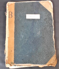
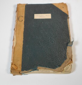
Document - RESIDENCE AREAS REGISTER SANDHURST: VOLUME 19 INDEX (1 of 2), not given
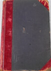
... ... land registers...History House 11 Mackenzie Street Bendigo goldfields PLACE Bendigo residence areas Bendigo Sandhurst land registers land sales residence areas Index book: Hard cover book with black cover, spine bound in red. ...Index book: Hard cover book with black cover, spine bound in red. Index to Register 19. Inside front cover is plastic pocket containing correspondence re widening of Northern Highway, Huntly effecting Mrs. Mary Jane Muston.place, bendigo, residence areas, bendigo, sandhurst, land registers, land sales, residence areas -
 Bendigo Historical Society Inc.
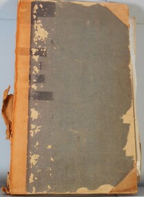
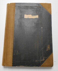
Document - RESIDENCE AREAS REGISTER: SANDHURST VOLUME 13, 1890 - 1892
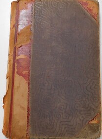
... ... land registers...History House 11 Mackenzie Street Bendigo goldfields PLACE residence areas Bendigo Sandhurst land sales land registers Register: hard covered register, maroon material with red spine and corners. ...Register: hard covered register, maroon material with red spine and corners. Contains A-Z index in front section linked with registration details of residence areas in the Sandhurst district, Sandhurst division. Written on front cover in gold ' Residence Areas Register' Pages 1 - 401. Dates from 19 June 1890 to 1 February 1892. Inside front cover, loose index sheets for Volume 13.place, residence areas, bendigo, sandhurst, land sales, land registers -
 Bendigo Historical Society Inc.
Archive - LAND TAX REGISTER, 1888
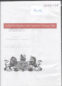
... LAND TAX REGISTER...Land tax register...DVD. Land Tax Register and Valuation Victoria 1888....Land tax register 1888 DVD. Land Tax Register and Valuation Victoria 1888. ...DVD. Land Tax Register and Valuation Victoria 1888.land tax register, 1888 -
 Bendigo Historical Society Inc.
Document - CONNELLY, TATCHELL, DUNLOP COLLECTION: DEED OF COVENANT MR. J.B. DAVIES TO T. LUXTON
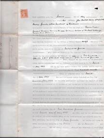
... Pale blue two page document between John Bartlett Davies of Happy Valley Bendigo formerly called Sandhurst, gentleman, land registered in Office of Titles number 101598....Pale blue two page document between John Bartlett Davies of Happy Valley Bendigo formerly called Sandhurst, gentleman, land registered in Office of Titles number 101598. ...Deed of Covenant between Mr. J.B. Davies to T. Luxton Esq., dated 5 August 1892. Pale blue two page document between John Bartlett Davies of Happy Valley Bendigo formerly called Sandhurst, gentleman, land registered in Office of Titles number 101598.cottage, miners, j.b. davies, happy valley road, thomas luxton, bendigo, sandhurst, deed of covenant -
 Bendigo Historical Society Inc.
Administrative record - Land Register
... Land Register...Land Register...Title on the front says - Bendigo Sec 12, Register. Large land register book. Board cover and back - covered by material of blue silk and leather. ...Dates approx. ~ 1895 - 1949 Administrative record Land Register ...Title on the front says - Bendigo Sec 12, Register. Large land register book. Board cover and back - covered by material of blue silk and leather. Paper on the inside - 101 pages - handwritten. Each page is divided into application numbers, full names, dates of application, parish of address, and details regarding the land and what is being done with it. Dates approx. ~ 1895 - 1949Written on spine - 5 12 1 7 1. Front cover large capital B on the side of the cover and in the middle is Bendigo Sec 12 Register. land register, financial, bendigo -
 Bendigo Historical Society Inc.
Legal record - Land Register
... Land Register ...Land Register...Land register for duration 1924 to 1951 (!!). Register contains plans of Land sales for a broad area of Central Victorian Parish / Counties. ...History House 11 Mackenzie Street Bendigo goldfields Land Register Central Victoria Land register for duration 1924 to 1951 (!!). ...Land register for duration 1924 to 1951 (!!). Register contains plans of Land sales for a broad area of Central Victorian Parish / Counties. Register has a stiff blue card cover originally bound with light brown leather spine and corners, presently in a dire condition with cover damaged and loose; plans also folded and damaged. Plans inserted as drawn plans within the register, later plans are included on tracing, paper and linen - in various degrees of condition / damage.land register, central victoria -
 Bendigo Historical Society Inc.
Administrative record - Land Sales Register - Castlemaine sec. 12
... Land Sales Register - Castlemaine sec. 12...The book is a register of land sales. The sales are recorded in alphabetical order. ...Administrative record Land Sales Register - Castlemaine sec. 12 ...Book has a blue cover and brown leather spine. The book is a register of land sales. The sales are recorded in alphabetical order. The records give the number of the application, the date of registry, the date of application, the surname of the purchaser, the Christian name and address, the parish, allotment, section and area, the decision, special condition, the license and remarks. The book covers the years from 1896 to the 1940's. On the cover a white sticker with the words: "Castlemaine Sec 12 register" and in texter the number 26 and letter C. On the spine "S 12 171"land sales, castlemaine -
 Bendigo Historical Society Inc.
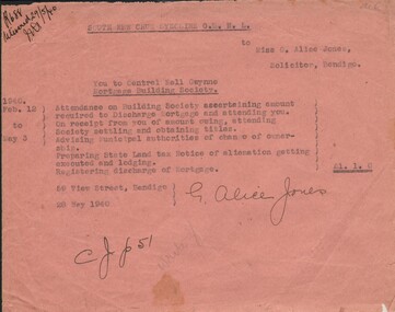
Document - MISS G ALICE JONES COLLECTION: ACCOUNT
... Account for work involved in the Discharge of Mortgage, preparing State Land tax Notice and registering discharge of Mortgage. ...Account for work involved in the Discharge of Mortgage, preparing State Land tax Notice and registering discharge of Mortgage. Cost £1.1.0. ...South New Chum Syncline G.M. N.L. to Miss G. Alice Jones. Pink paper dated Feb. 12 to May 3, 1940, and 28 May 1940. Account for work involved in the Discharge of Mortgage, preparing State Land tax Notice and registering discharge of Mortgage. Cost £1.1.0. "R688 delivered 29/5/40" in top left corner.the miss g alice jones collection - account, south new chum syncline g.m. n.l. -
 Bendigo Historical Society Inc.
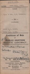
Document - H.A. & S.R. WILKINSON COLLECTION: CONDITION OF SALE
... Bice as tenant, being the land in conveyance registered No. 66, book 589. Also the land untransferred in certificate of title volume 5350 folio 1071748 Crown allotment 19 section 11B, together with 5-roomed brick and weatherboard dwelling and all sundry. ...Bice as tenant, being the land in conveyance registered No. 66, book 589. Also the land untransferred in certificate of title volume 5350 folio 1071748 Crown allotment 19 section 11B, together with 5-roomed brick and weatherboard dwelling and all sundry. ...BHS CollectionConditions of sale by private contract dated 22nd July, 1947 between N.E. & Mrs. B. E. Woodall (sellers) and Mrs N.I. Rigby & Mrs D.M. Sayer (buyer) for land situate 86 Violet Street Bendigo, at present occupied by Mr. Bice as tenant, being the land in conveyance registered No. 66, book 589. Also the land untransferred in certificate of title volume 5350 folio 1071748 Crown allotment 19 section 11B, together with 5-roomed brick and weatherboard dwelling and all sundry. Price 600 pounds.organization, business, h.a. & s.r wilkinson real estate -
 Bendigo Historical Society Inc.
Document - LANDS OFFICE BENDIGO LITHO REGISTER, Jan. 1952 - Feb. 1978
... Document: hard cover journal, black cover with buff spine and corners. Contains register of land maps sold by Bendigo Lands Office. ...History House 11 Mackenzie Street Bendigo goldfields Bendigo Lands Office litho register Lands Office Bendigo Document: hard cover journal, black cover with buff spine and corners. Contains register of land maps sold by Bendigo Lands Office. ...Document: hard cover journal, black cover with buff spine and corners. Contains register of land maps sold by Bendigo Lands Office. Handwritten entries on ruled pages. LH page: date, number received, name of plan, litho number, price, amount, date, name of plan, price, number sold, amount, number used in office, amount. Rh page: repeat of LH page.Lands Office Bendigobendigo, lands office, litho register -
 Bendigo Historical Society Inc.
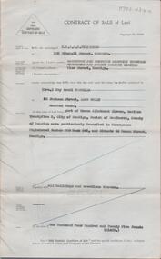
Document - H. A. & S. R. WILKINSON COLLECTION: CONTRACT OF SALE
... Property: land being part of Crown allotment 11 section 25B Parish of Sandhurst City of Bendigo, land described in Conveyance registered number880 book 543 and situate 44 Rowan Street, Bendigo, together with all buildings thereon. ...Property: land being part of Crown allotment 11 section 25B Parish of Sandhurst City of Bendigo, land described in Conveyance registered number880 book 543 and situate 44 Rowan Street, Bendigo, together with all buildings thereon. ...Contract of sale of land dated 29th January, 1954 between Sandhurst & Northern District Trustees Executors and Agency, Estate of M. J. Wearne - Deceased (vendor) and Mrs. I. P. Trewella (purchaser). Property: land being part of Crown allotment 11 section 25B Parish of Sandhurst City of Bendigo, land described in Conveyance registered number880 book 543 and situate 44 Rowan Street, Bendigo, together with all buildings thereon. Price: 1,425 pounds .organization, business, h.a. & s.r wilkinson real estate -
 Orbost & District Historical Society
register, Register of Residence Areas, 10.2.1897 - 4.9.1934
... This book is a register of land holders with miners' rights. The correspondence is associated with applications for miners' rights on privately owned land and business sites. ...Orbost & District Historical Society Ruskin Street Orbost gippsland This book is a register of land holders with miners' rights. The correspondence is associated with applications for miners' rights on privately owned land and business sites. ...This book is a register of land holders with miners' rights. The correspondence is associated with applications for miners' rights on privately owned land and business sites. They include application fotrms and objections to registrations. The areas referred to are Combienbar, Goongerah, Club Terrace, Wombat Creek and Dundong. One of the privileges under the Mines Act, conferred by the holding of a miner's right until 1935 was that of residence on up to one acre on a gold-fields area. Those occupying a residence area were "deemed in law to be possessed ... of such ... parcels ... and the property therein".This is a useful research tool.A large, heavy book with a grey cloth cover and red spine. The end papers are marbled. The inside pages are ruled in grey with red ruled columns. Entries are hand-written. There are copies of correspondence inside. Details given are the registration number and date, the name of the person, the number of the miner's right and its date, a description of the allotment and any remarks or references to other volumes. Any changes of ownership are shown. The book is mostly unused.register-mining miners-rights -
 Kiewa Valley Historical Society
Photograph - 30 black and white photographs (assorted sizes) plus page from a newspaper and copied article on A4 paper, c1880's c1910 - 1920 (photographs) Newspaper 1961
... land clearing for farming. The photos of Mt. Buffalo Chalet have social, architectural and historical significance. the Chalet has been used by skiers, bush walkers and day trippers since its completion in 1910 and its closure in 2006. It is listed in the Victorian Heritage Register ...K2,3 and4 are of the Kiewa River and two of the bridges spanning the river along the valley. K3 and K4 would have been taken in the 1880's and show the type of trees and plant growth along the river prior to land clearing for farming. K5 is of the Running Creek Cricket Team and therefore there was sufficient population in the area to form and maintain a team as well as have other teams in the relatively near vicinity to provide competition. Note the horse drawn cart which provided transport. Date taken is unknown but possibly c 1910. The Mt. Buffalo Chalet was built in 1910 by the Victorian Government. It was Australia's first ski resort and has served generations of skiiers, hikers and families over the years. It was built for 3195 pounds and has had stories and wings added since and is the largest timber building in Australia. B4 is the earliest photo in this group as the garden is in early stages of development - the other photos show the growth of the shrubs and would be taken about c 1920. Note the cars and motor bikes. It closed in 2006. The other photos are of general interest only but interesting to see that there were donkey's grazing. There is no information as to their purpose on Mt. Buffalo. Four different Kiewa Valley families are represented in the photographs. Their descendants still live in the Valley and carry on the traditions of beef and dairy farming. Of particular interest is the photo of Miss Marjorie Clemence, the first School Teacher of Upper Gundowring School. Gundowring pastoral run was taken up in 1838 and occupied by framers in the 1860's. The area was known as Gundowring and Upper Gundowring. The Gundowring School was opened in 1871 and most likely the Upper Gundowring school would be built at the same time. It was School No. 2733 and situated in Boyd Road. It closed in 1953 when the Kiewa Consolidated School opened. The newspaper page describes the activities in which the local community of Kergunyah were in engaged in that period - Red Cross, Fire Brigade, cattle round up and some of the identities involved. The article photocopied from the Yackandandah times states that he (Norman Coad) "was sent to the Ovens District Hospital, Beechworth for treatment" which would mean that this was the closest hospital to the Kiewa Valley for emergencies in 1912.The Kiewa Valley photographs are of social significance showing two of the early bridges allowing the community easy access to both sides of the river and also the tree and plant growth before land clearing for farming. The photos of Mt. Buffalo Chalet have social, architectural and historical significance. the Chalet has been used by skiers, bush walkers and day trippers since its completion in 1910 and its closure in 2006. It is listed in the Victorian Heritage Register. The family photographs are of social and historical significance as they are of early farming families in the Kiewa Valley and also depict the dress, of both men and women) in the late 1880's. The write up in the Weekly Times has social significance as it depicts the social and farming activities and photos of the local residents from around that area. The article from the Yackandandah Times is of a personal nature with concern for the individual involved. Note: There is a photo of the gentleman mentioned in the article (Mr. Norman Coad) in the Families of the Kiewa Valley (F4) as above.30 black and white photographs - 5 of the Kiewa Valley, 8 of families of the Kiewa Vallley and 17 of Mt. Buffalo. Various sized photos. Page from the Weekly times and copied article from the Yackandandah Times on A4 sheet.(Note for easier identification they have been numbered and grouped - K1-5 (Kiewa Valley), F1-8 (Families) and B1-17 (Mt. Buffalo). K1: handwritten in ink, lower L hand corner "Bogong in the distance". K2: handwritten in ink lower L hand corner "Mongan's Bridge or Towonga". K3 handwritten in ink "Taken from Mongan Bridge looking up stream". K4 - no inscription. K5: handwritten in ink, back of photo "Running Creek Cricket Team". F1: handwritten in ink on back "Mrs. Heap" and lower down in pencil "1880's". F2 handwritten in pencil at top of back phot "Land at Tawonga TROVE The Y'dah Times 20/2/1913" and lower down in ink "Henry Ellis Larkin". F3: handwritten in ink bottom edge "Mrs Coad". Note that this photo is a postcard. F4: Written in ink lower edge "Norman Coad". Note this photo is also a postcard. F5: Lower left corner in Ink "Harry Larkin". F6: lower half back of photo, in ink "Bernie Maddison". F7: on back of photograph in ink "Miss Marjorie Clemence first School Teacher Upper Gundowring: and underneath, in pencil "C1880's". F8: Handwritten in ink on back of photo "Frank & Mrs. Keat & Lesley of Tawonga". Lower down in pencil "c1912-1914". B1: Back of photo in ink "The Chalet Mt. Buffalo". B2: no inscription. B3: "chalet at Bufflo" in ink lower left corner. B4: This is a post card. Written in ink is "Mt. Buffalo Chalet". B5 - B10 printed in ink, lower left corner "Buffalo". B11: no inscription. B12: "Mt. Buffalo" lower R corner. B13: "Buffalo?". B15: Printed in ink lower edge "Picnic at Buffalo". B16: "Donkeys on Mt. Buffalo" printed in ink lower edge. B17: handwritten in ink across back of photo "Donkeys & top of Mt. Buffalo with the Monileith in the distance". A4 sheet of paper describing an accident to Mr. Norman Coad. Under article is : Yackandandah Times (Vic: 1890 - 1931), Thursday 18 July 1912, page 3. A page torn from the Weekly Times, June 14, 1961 and entitled "Kergunyah has picturesque setting". kiewa valley, farming, families, kergunyah, gundowring upper, mt. buffalo chalet, briggs family, larki family, coad family, clemence family, laskowski collection -
 Kiewa Valley Historical Society
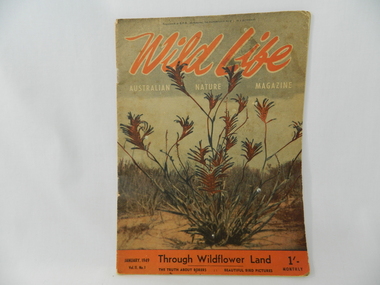
Magazine - Nature, Joseph Swanson Wilkinson, Wild Life Australian Nature Magazine, January 1949
... Registered at G.P.O. Melbourne for transmission by post as a periodical'. written in black in tiny print across the top. 1st line: 'Wild Life' in orange with white outline. 2nd line: 'Australian Nature Magazine' in white underneath title. All across top. 3rd written line: 'January, 1949 Through Wildflower Land...Registered at G.P.O. Melbourne for transmission by post as a periodical'. written in black in tiny print across the top. 1st line: 'Wild Life' in orange with white outline. 2nd line: 'Australian Nature Magazine' in white underneath title. All across top. 3rd written line: 'January, 1949 Through Wildflower Land ...This magazine was part of the Bogong School's library and represents an important aspect of the school's curriculum.Bogong School was noted for having a great interest in nature and conservation. 48 page soft covered magazine. Cover with limited colour including orange, black, white and brown with green. Inside pages in black, brown and grey pictures with black print on off white pages. Page 41 is in cartoon form. 'Registered at G.P.O. Melbourne for transmission by post as a periodical'. written in black in tiny print across the top. 1st line: 'Wild Life' in orange with white outline. 2nd line: 'Australian Nature Magazine' in white underneath title. All across top. 3rd written line: 'January, 1949 Through Wildflower Land 1/-' underneath picture of Kangaroo Paw. in black Underneath this writing follows: 4th line: 'Vol.11 No. 1 The Truth About Borers : : Beautiful Bird Pictures' in black Underneath 1/- is 'Monthly' Background behind black writing is orange same as title.bogong primary school. bogong. wild life. nature. -
 Kiewa Valley Historical Society
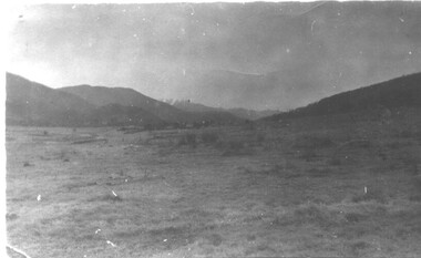
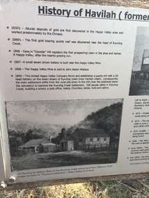
Papers - Havilah Cemetery, Havilah Cemetery Formerly Running Creek Cemetery
... land for a cemetery. Their request was granted. The Cemetery was decommissioned in the early 1950s and the last trustee for the cemetery died in 1986. There is a wooden fence around the boundary (May 2024). One paper lists 29 names in the Burial Register...land for a cemetery. Their request was granted. The Cemetery was decommissioned in the early 1950s and the last trustee for the cemetery died in 1986. There is a wooden fence around the boundary (May 2024). One paper lists 29 names in the Burial Register ...In 1889, 24 residents of the Running Creek and surrounding district submitted a petition to the Minister of Lands, Melbourne requesting land for a cemetery. Their request was granted. The Cemetery was decommissioned in the early 1950s and the last trustee for the cemetery died in 1986. There is a wooden fence around the boundary (May 2024). One paper lists 29 names in the Burial Register 1861-1948. The last two sheets record the history as a timeline from the 1850s to the 1900s. Havilah was a gold mining settlement from the 1850s located 20km west of the Kiewa Valley and in the Ovens catchment near Myrtleford.Five black and white A4 pages stapled together. Copies of the sign erected at the gate of 'Havilah cemetery formerly Running Creek Cemetery'. Also the 'History of Havilah formerly Running Creek'havilah, running creek, cemetery -
 Port of Echuca
Black and white photograph, Approx.1980
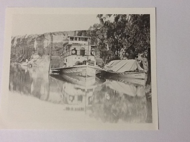
... Registered tonnage: gross 128, net 92. Dimensions:L.103.3 ft B.18.5ft. D 5.7ft. Port and date of registry:Adelaide, 1880, no.43, 154. Built at Goolwa, S.A., 1865!. Owner: Chas Oliver. Lengthened in 1872. Details of barge Bourke. Construction:wood. Tonnage: 124. Dimensions:L 108.5 ft X B 20.5 ft X D 8.0 ft. Port and date of registry:Adelaide, 1898, no. 74, 771. built at: Miland, S. A. 1876. Owner: A. L. Land...Registered tonnage: gross 128, net 92. Dimensions:L.103.3 ft B.18.5ft. D 5.7ft. Port and date of registry:Adelaide, 1880, no.43, 154. Built at Goolwa, S.A., 1865!. Owner: Chas Oliver. Lengthened in 1872. Details of barge Bourke. Construction:wood. Tonnage: 124. Dimensions:L 108.5 ft X B 20.5 ft X D 8.0 ft. Port and date of registry:Adelaide, 1898, no. 74, 771. built at: Miland, S. A. 1876. Owner: A. L. Land ...Details of P. S. Queen: construction: composite 16 h.p. Registered tonnage: gross 128, net 92. Dimensions:L.103.3 ft B.18.5ft. D 5.7ft. Port and date of registry:Adelaide, 1880, no.43, 154. Built at Goolwa, S.A., 1865!. Owner: Chas Oliver. Lengthened in 1872. Details of barge Bourke. Construction:wood. Tonnage: 124. Dimensions:L 108.5 ft X B 20.5 ft X D 8.0 ft. Port and date of registry:Adelaide, 1898, no. 74, 771. built at: Miland, S. A. 1876. Owner: A. L. Land seer. Information from "The register of Australian & N. Z. Shipping 1898. This photograph has historical and social significance being typical of transport on the rivers systems of Australia in the late 1800s. Paddlesteamers carried supples to settlers and then carried their produce such as Wool and other produce down the rivers to markets or to be transferred by rail to the major ports such as Melbourne or Adelaide. Black and white photograph of P. S. Queen with the barge Bourke rigged to its side. Photographed in a gorge where boats appear to be moored. Photograph taken from the bow of the Queen with 3 people visible on the port side of the boat and there appear to be sacks stacked on the front of the boat. The barge Bourke has a tent structured tarp over it. Copy of an original photograph (date unknown)Inscription in pencil on reverse:Queen. On the photograph can be seen "Queen" on the bow and partically on the wheelhouse. The barge has "Bourke" visible on its bow.p. s. queen, bourke barge, paddle steamers -
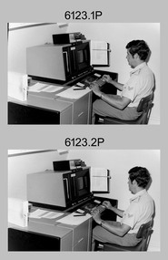 Bendigo Military Museum
photograph - Cartographic Squadron Production – Army Survey Regiment, Fortuna, c1980
... SPR Gina (Coore) Neilson is seen in photo .11P washing a contone positive of a land mass in a solution. The contone components were registered to the map sheet, as shown in photo .12P and masked using an air brush and a halftone negative was then created. ...SPR Gina (Coore) Neilson is seen in photo .11P washing a contone positive of a land mass in a solution. The contone components were registered to the map sheet, as shown in photo .12P and masked using an air brush and a halftone negative was then created. ...This collection of 12 photos was most likely taken in 1980. The photos were most likely taken in Cartographic Squadron’s Ante Room, the Attic and small offices on the top floor of Fortuna Villa. The computer based Editwriter typesetting system was introduced in 1975 as a replacement to the aging Fotosetter machine. It was operated by a specialised technician, who generated a large variety of map type styles and sizes quickly and reliably, as well as text panels. CPL Richards performed this task for several years and in photo .1P and .2P is reading off a type order next to the computer monitor. Output on Copy proof adhesive backed stripping type film replaced messy wax and spray adhesives in 1978. The Editwriter capability supported all RASvy units and contractor type setting requirements. Scribing was the cartographic process of drafting features such as drainage, relief, vegetation, roads and culture on specially coated map reproduction material. The cartographic technician scribed out the map feature such as a contour to a specified line width on the map sheet, using a tool affixed with a sapphire tipped cutter. The quality control edit (Proving) stage of map production was the first opportunity to inspect a proof of the map independently and systematically. Proving tasks were carried out by technicians conversant of the map product specification and task requirement, however, was not involved in its production. Corrections were identified, marked up and sent to back to the correcting section or contractors. Terrain Embossing was a manual map production technique to produce hill shading on medium to small scale graphics and air charts. SPR John Martin is seen in photos .8P to.10P using a fine embossing metal stylus to push down on the drainage impression on a thin malleable opaque plastic material (AK Poligraphy). Ridge lines were then pushed down using the contour impression as a guide, on the opposing side of the AK Poligraphy to create a 3D plastic model terrain effect. The map impression was sprayed with white paint and photographed to create a contone tone hill shade. SPR Gina (Coore) Neilson is seen in photo .11P washing a contone positive of a land mass in a solution. The contone components were registered to the map sheet, as shown in photo .12P and masked using an air brush and a halftone negative was then created. The terrain embossing method of producing hill shading was more efficient to produce than previous specialised artistic methods such pencil/eraser and air brush. Furthermore, a more consistent enhancement of terrain on charts was achieved between technicians.This is a set of 12 photographs of Cartographic Squadron performing four map production tasks at the Army Survey Regiment, Fortuna, Bendigo c1980. The first ten photographs were on 35mm negative film and were scanned at 96 dpi. Photos .11P and .12P were on photographic paper and scanned at 300 dpi. They are part of the Army Survey Regiment’s Collection. .1) - Photo, black & white, c1980, Editwriter typesetter, CPL Paul Richards. .2) - Photo, black & white, c1980, Editwriter typesetter, CPL Paul Richards. .3) - Photo, black & white, c1980, Scribing contours on a RAAF Chart, SPR Megan (McBurney) Reynolds. .4) - Photo, black & white, c1980, Scribing contours on a RAAF Chart, SPR Megan (McBurney) Reynolds. .5) - Photo, black & white, c1980, Scribing contours on a RAAF Chart, SPR Rod Skidmore. .6) - Photo, black & white, c1980, Scribing contours on a RAAF Chart, SPR Rod Skidmore. .7) - Photo, black & white, c1980, Formal quality control edit (Proving), CPL Ian Belmont. .8) - Photo, black & white, c1980, Hill Shade Terrain Embossing, SPR John Martin. .9) - Photo, black & white, c1980, Hill Shade Terrain Embossing, SPR John Martin. .10) - Photo, black & white, c1980, Hill Shade Terrain Embossing, SPR John Martin. .11) - Photo, black & white, c1980, Hill Shade Terrain Embossing, SPR Gina (Coore) Neilson. .12) - Photo, black & white, c1980, Hill Shade Terrain Embossing, unidentified..1P to .10P No personnel are identified. .11P and .12P annotated ‘Terrain Embossing’royal australian survey corps, rasvy, army survey regiment, army svy regt, fortuna, asr, carto -
 4th/19th Prince of Wales's Light Horse Regiment Unit History Room
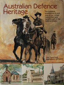
Book, Australian Defence Heritage, 1988 (exact)
... land used either as training areas or for operational and logistic bases. Approximately 200 Defence-occupied buildings have been classified by the Australian Heritage Commission and placed on the Register of the National Estate, and a further 100 buildings have been registered by the National Trust. ...land used either as training areas or for operational and logistic bases. Approximately 200 Defence-occupied buildings have been classified by the Australian Heritage Commission and placed on the Register of the National Estate, and a further 100 buildings have been registered by the National Trust. ...The Department of Defence controls more than two million hectares of land used either as training areas or for operational and logistic bases. Approximately 200 Defence-occupied buildings have been classified by the Australian Heritage Commission and placed on the Register of the National Estate, and a further 100 buildings have been registered by the National Trust. Twenty properties also have been listed by the Australian Heritage Commission for significant environmental aspects and for the protection of Aboriginal sites. This book, produced as a contribution to Australia's bicentennial, is the first publication devoted entirely to Australia's priceless defence heritage. Text: Frank Doak Illustrations: Jeff IsaacsISBN 949 054 968heritage, books, defence estate, national estate, national trust, aboriginal sites, australian heritage commission, defence properties, frank doak, jeff isaacs, fairfax library, heritage, books, defence estate, national estate, national trust, aboriginal sites, australian heritage commission, defence properties, frank doak, jeff isaacs, fairfax library -
 Orbost & District Historical Society
display cabinet and tools
... The name “ Curlip” is derived from the indigenous name for the area where Tabbara is located and includes land to the east of the Snowy and Brodribb Rivers towards Cape Conran. PS Curlip was registered in 1893 and the Passenger Certificate issued on 30th January 1903 to Captain Alan Richardson by the Marine Board of Victoria entitled her to carry 25 passengers and only 10 passengers when engaged in towage service. ...The name “ Curlip” is derived from the indigenous name for the area where Tabbara is located and includes land to the east of the Snowy and Brodribb Rivers towards Cape Conran. PS Curlip was registered in 1893 and the Passenger Certificate issued on 30th January 1903 to Captain Alan Richardson by the Marine Board of Victoria entitled her to carry 25 passengers and only 10 passengers when engaged in towage service. ...This display was put together by the Curlip Committee and used as promotion in the shed during the construction of Curlip 11 A community project, this boat was constructed out of local hardwood timbers utilizing the traditional skills of wooden boat builders and is powered by a steam engine. Paddle Steamer Curlip II is a replica of an historic paddle steamer of the Snowy River, in Far East Gippsland, Victoria. The original Paddle Steamer Curlip was built by Sam Richardson and his sons Mark, Albert and Frank, at their sawmill at Tabbara, a pioneering settlement on the Brodribb River, a tributary of the Snowy River. The keel was laid on 14th October 1889 and PS Curlip was launched in 1890. The name “ Curlip” is derived from the indigenous name for the area where Tabbara is located and includes land to the east of the Snowy and Brodribb Rivers towards Cape Conran. PS Curlip was registered in 1893 and the Passenger Certificate issued on 30th January 1903 to Captain Alan Richardson by the Marine Board of Victoria entitled her to carry 25 passengers and only 10 passengers when engaged in towage service. Two children under 12 years of age to be reckoned as one passenger. PS Curlip towed five barges at a time, traveling upstream as far as Bete Bolong, 20 km upstream of the mouth to collect produce to be transferred to schooners near Marlo. She towed vessels in and out through the Snowy river entrance and was also used for social functions such as Sunday School picnics. She was the main means of transport for imports and exports on the Snowy River for almost 30 years. The Curlip era ended abruptly on Friday 28th February when a flash flood carried her and 2 barges down river and out to sea, where she washed ashore at Marlo and broke up.More than eighty years after the original Paddle Steamer Curlip was wrecked at sea, the Orbost community launched a replica which it hoped would draw tourists to the region. The P.S. Curlip II, is based on drawings of the original Curlip that made its home in the Snowy and Brodribb Rivers of East Gippsland in the 1890s and early 1900s, It took six years of planning and hundreds of hours of volunteer work from the local community.A display cabinet containing tools and sundry items related to the Paddle Steamer Curlip. (More information on individual items in Catalogue 1400-1600)p.s.curlip richardson-samuel boat-building-tools transport -
 Federation University Historical Collection
Booklet, Ballarat School of Mines Register of Attendances for Land Surveying, 1908, 1908
... Ballarat School of Mines Register of Attendances for Land Surveying, 1908...Barker Library (top floor) Mount Helen goldfields The Ballarat School of Mines is a predecessor institution of Federation University Australia. ballarat school of mines a.d. gilchrist land surveying A slim, green pastel, hard cover volume with dark blue spine. Two full-width pages for entering names of those enrolled. Ballarat School of Mines Register ...The Ballarat School of Mines is a predecessor institution of Federation University Australia. A slim, green pastel, hard cover volume with dark blue spine. Two full-width pages for entering names of those enrolled.ballarat school of mines, a.d. gilchrist, land surveying -
Federation University Historical Collection
Booklet, Ballarat School of Mines Register of Attendances for Land Surveying, 1909, 1909
... Ballarat School of Mines Register of Attendances for Land Surveying, 1909...Barker Library (top floor) Mount Helen goldfields The Ballarat School of Mines is a predecessor institution of Federation University Australia. ballarat school of mines a.d. gilchrist land surveying A slim, green pastel, hard cover volume with dark blue spine. Two full-width pages for entering names of those enrolled. Ballarat School of Mines Register ...The Ballarat School of Mines is a predecessor institution of Federation University Australia. A slim, green pastel, hard cover volume with dark blue spine. Two full-width pages for entering names of those enrolled.ballarat school of mines, a.d. gilchrist, land surveying -
 Federation University Historical Collection
Document, Grant, by Purchase, Ballarat, Victoria, 1856, 1856
... The land was in the County of Grant, Parish of Ballarat. Record of Register of Town Purchase, No. 50, Page 156 on 20 April 1856 and signed by William C Haines....The land was in the County of Grant, Parish of Ballarat. Record of Register of Town Purchase, No. 50, Page 156 on 20 April 1856 and signed by William C Haines. thomas bath county of grant parish of ballarat william c haines colonial secretary edward macarthur Official seal Dated 9 April 1856 Signed: E Macarthur - Major General Edward Macarthur Signed: William C Haines - Colonial Secretary Thick cream paper, badly stained. ...Thomas Bath of Ballarat became the purchaser of a parcel of land for the sum of Five Hundred Pounds. The land was in the County of Grant, Parish of Ballarat. Record of Register of Town Purchase, No. 50, Page 156 on 20 April 1856 and signed by William C Haines.Thick cream paper, badly stained. Hanad written Official seal Dated 9 April 1856 Signed: E Macarthur - Major General Edward Macarthur Signed: William C Haines - Colonial Secretarythomas bath, county of grant, parish of ballarat, william c haines, colonial secretary, edward macarthur -
 Upper Yarra Museum
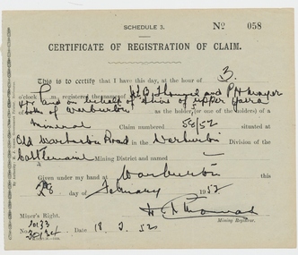
Document, Circa 1952
... A person wanting to dig for Gold or any other precious metal were required to register a claim on the land to be mined, the claim had to be measured & pegged to be specific as to its size and shape....Upper Yarra Museum Old Railway Station 2415C Warburton Highway Yarra Junction yarra-valley-and-dandenong-ranges A person wanting to dig for Gold or any other precious metal were required to register a claim on the land to be mined, the claim had to be measured & pegged to be specific as to its size and shape. gold document certificate miners claim Certificate Miners Claim No 058 Document ...A person wanting to dig for Gold or any other precious metal were required to register a claim on the land to be mined, the claim had to be measured & pegged to be specific as to its size and shape.Certificate Miners Claim No 058gold, document, certificate, miners claim -
 Eltham District Historical Society Inc
Photograph - Aerial Photograph, Landata, Eltham; Crown Allotment 15, Section 5, Parish of Nillumbik (Stokes Orchard Estate), Dec. 1945
... On November 27, 1964, the State Electricity Commission served notice to compulsorily acquire a further parcel through the eastern part of the land for a major electricity transmission line that augmented supply from the La Trobe Valley to Melbourne. The easement was registered...On November 27, 1964, the State Electricity Commission served notice to compulsorily acquire a further parcel through the eastern part of the land for a major electricity transmission line that augmented supply from the La Trobe Valley to Melbourne. The easement was registered ...Centred on present day Diosma Rd, Stokes Pl, Nyora Rd and Eucalyptus Rd Historic Aerial Imagery Source: Landata.vic.gov.au Aerial Photo Details: Project No :5 Project : MELBOURNE AND METROPOLITAN AREA PROJECT Run : 36 Frame : 60546 Date : 12/1945 Film Type : B/W Camera : EAG4 Flying Height : 10200 Scale : 6000 Film Number : 195 GDA2020 : 37°42'47"S, 145°09'56"E MGA2020 : 338306, 5824438 (55) Melways : 22 C4 (ed. 42) A History of the Development of Crown Allotment 15, Section 5, Parish of Nillumbik – Stokes Orchard Crown Allotment 15, Section 5, Parish of Nillumbik (CA15) is a square allotment of 158 acres or approximately a quarter of a square mile. It lies just beyond the eastern end of Pitt Street, south of Nyora Road to the northern end of Eucalyptus Road and extends east from Eucalyptus Road to Reynolds Road. The topography of CA15 is generally steep, sloping up to a hill near the centre of the land, the ridgeline passing through the properties along the southern side of Diosma Road. Eucalyptus Road is a straight north-south road with its northern end at the north west corner of CA15. Until the end of the 1970s this road was an un-named Government Road and was largely not open to traffic. With residential development in the 1970s the road was constructed, and the council allocated the name obviously in recognition of the predominant species of the local bushland. CA15 was purchased from the Crown by George D’Arley Boursiquot, a prominent Melbourne printer, on 28th October 1852. On November 23, 1922, former Member for Gippsland and Melbourne Real Estate Agent, Hubert Patrick Keogh purchased the allotment then sold it March 13, 1925, to local farmer, Robert David Taylor, a former Shire of Eltham Councillor (1911-1920) and Shire President (1919). Taylor had extensive land holdings stretching west towards Bible Street and Main Road. The Taylor home was situated at the top of the hill in Bible Street at present day 82 Bible Street. At the time of Taylor’s purchase in 1925, CA15 was subdivided into 48 lots that could be described as small rural properties or large residential lots. A typical lot size was one hectare or 2.5 acres. The subdivision created two roads, Nyora Road, and Diosma Road, each following an irregular alignment between Eucalyptus and Reynolds Roads. However, the lots were not sold off separately nor were the roads constructed. The land effectively remained as one parcel for many further years. Robert David Taylor died November 30, 1934, and probate was granted to his son of the same name, Robert David Taylor of Bible Street, Salesman and William McLelland Vance Taylor of 73 Emmeline Street, Northcote, Clerk, with the transfer of the land into their names on July 8, 1935. Frank Stokes worked as a qualified accountant at Kennons leather factory in Burnley, while living at 1 Thomas Street, Mitcham. He suffered from migraines and wanted to return to working the land (he had previously worked on farms and orchards since coming to Australia from England in 1926, both in WA and Vic.). He first travelled to the district by train in July 1942 to find land with the intention to establish an orchard. By chance he met Arthur Bird of Bird Orchard (bounded by Pitt Street, Eucalyptus Road, and Wattle Grove) and they got talking over their common interest. Arthur put Frank up for the night and pointed out the land, 158 acres- part of the Taylor Estate- £900, Crown Allotment 15, Section 5, Parish of Nillumbik (CA15) somewhat diagonally opposite Bird Orchard. Stokes applied through the Riverina Agency to purchase the land who in turn applied for permission from Canberra to sell as there was a new government regulation introduced during the Second World War banning land sales except for immediate production. Stokes obtained a loan on his Mitcham house of £600 @ 5% and paid £450 deposit with quarterly payments of £15 spread over 5 years. Stokes was assisted and advised by Arthur Bird who farmed the neighbouring orchard. In early 1943 Stokes took possession and would catch the train out to Eltham on Fridays after work and began building a hut on the corner of Nyora Road and the Government Road (Eucalyptus Road) for shelter and to lock up tools. He established an orchard on the central western part of the land through the centre of which ran a natural waterway (part of the present-day linear park) and was able to pay a neighbour (Hawkins) to help with clearing and fencing 25 acres, and with a horse and single furrowed plough, planted approximately 2,500 fruit trees - cherries, peaches, plums, almonds, pears, apricots and lemons as well as a few apples and oranges; a massive task. Aerial photographs from the 1940s through to the 1990s clearly show the orchard with most of the larger CA15 site remaining as natural bushland. A huge problem was hares and rabbits eating all the new buds off the tiny trees. As well as laying poison he painted the trees with a mixture of cow manure and lime, often working by moonlight. Procurement of wire and wire netting was difficult because of the war but after much effort he obtained a permit from the Agricultural Department for supplies in March 1944. In February 1945 Stokes applied for a permit to build a “packing shed” as no house building was allowed. It was to be 33 feet x 21 feet and cost £312. It was constructed mostly from second-hand materials, which were hard to obtain, especially iron for roofing. Stokes finished work at Kennons on October 31, 1945, and in March 1946 he sold the family home at Mitcham for £1,230 plus £170 for furniture. On May 15, 1946, title to the CA15 property was issued to Frank Howard Alfred Stokes, Orchardist and Gladys Ethel Stokes, Married Woman, both of Pitt Street, Eltham. The family of five then moved into the very unfinished “packing shed” at Eltham, which was a struggle to weatherproof. Eventually rooms were divided off and lined with hessian bags and whitewashed. Their income was firewood (cut and sold), selling rockery stones and cut Sweet Bursaria. (It was discovered during the 1940s that Sweet Bursaria contained the sunscreen compound Aesculin. The RAAF utilised this compound from Sweet Bursaria during WW2 for pilots and gunners.) The orchard’s first fruit sale was a half-case of Le Vanq peaches in December 1947 for the price of 8 shillings. In 1956 plans for house were drawn and Glen Iris bricks purchased (1956 Olympic Rings variant). The building of the house commenced in 1957 - 12 feet of original packing shed was removed – and was completed in 1959. Water was connected from newly built pressure storage on the property at the end of 1959 and the electricity connection for the first time at 3pm on April 29, 1960. The house remains to present day (somewhat modified) at 1 Nyora Road, home to Nyora Studio Gallery. On occasions, spare remnants of the 1956 bricks have been known to be unearthed in gardens on the estate as they were utilised by Frank Stokes to fill in rabbit holes. On May 26, 1950, a parcel of land was compulsorily acquired by the Melbourne and Metropolitan Board of Works on the hilltop to establish an easement for a high-level service reservoir to augment Eltham’s water supply. The project also included pipe tracks for the necessary water mains. The reservoir has now been superseded by higher level water tanks east of Reynolds Road and its former site is now a public reserve. On November 27, 1964, the State Electricity Commission served notice to compulsorily acquire a further parcel through the eastern part of the land for a major electricity transmission line that augmented supply from the La Trobe Valley to Melbourne. The easement was registered February 11, 1966. The easement was widened July 18, 1969 for a second transmission line to be constructed. In 1971 Melbourne Metropolitan Planning Scheme amendments adopted Nyora Road as the boundary between a residential zone to the north and a rural zone to the south. This determined the future development of the land. In the mid-1970s the Shire of Eltham divided the orchard into numerous rate-able parcel lots, the 48 lots having been established in 1925 and the subsequent rates assessment proved unsustainable for Stokes. He commenced selling lots outside the boundary of the orchard, north of Diosma and South of Nyora. However shortly later the land between Nyora and Diosma Roads and west of the electricity easement was sold and subdivided into residential lots, a housing development by Macquarie Builders and marketed as the Stokes Orchard Estate. New streets were created, and most were named after trees, although one, Stokes Place, commemorates the former owners. The development was undertaken in two stages; Stage 1 (1975) encompassing Scarlet Ash Court, Ironbark Close and Peppermint Grove bounded by Nyora and Eucalyptus roads and Stage 2 (1978) encompassing Stokes Place, Orchard Way, The Crest and The Lookout bound by Nyora and Diosma roads. The developer, Macquarie Builders went bankrupt shortly after the release of Stage 2 leaving many purchasers to fend for themselves and arrange for their own independent builders. There were also difficulties with sewerage for the land immediately south of Diosma Road and so the conventional residential lots were abandoned in favour of larger lots. The development of Orchard Way, The Crest and The Lookout did not proceed as planned and the proposed lots were incorporated into five-acre parcels instead. These included a low-density group housing development by the Graves family and the award winning Choong House (1983) with Gordon Ford developed garden immediately next door situated on the ridge of the hill nestled amongst the original bush, Eucalypt trees and Sweet Bursaria. In 1994, Nillumbik Shire Council applied Significant Environment and Significant Landscape overlays upon the properties on the south side of Diosma Road to ensure protection of this natural bush garden environment. With the arrival of the sewer along Diosma Road in the 1990s, most of these five-acre parcels have since been subdivided multiple times. The Choong house presently sits on a 2.7-acre property, which in 2022 Nillumbik Council nominated for Cultural Significance Heritage protection and is considered potentially significant at State level. The Stokes family were also associated with the Eltham Christian Church. In the 1970s this church had met in temporary premises in Eltham. Lots of the original 1925 subdivision remained south of Nyora Road and a number of these lots were utilized for the Eltham Christian School, which was established by the Eltham Christian Church in 1981. The school operated on this site until 2000. The premises are now used by The Vine Baptist Church. By the mid-1980s the whole of CA15 had been developed for residential and school purposes, except for the sections north of Diosma Road and between the transmission lines and Reynolds Road. Sewerage issues had been resolved for the section north of Diosma Road and in 1987 it was in the process of being subdivided into residential lots. The development coincided with the discovery of colonies of the rare and endangered Eltham Copper Butterfly on the site. This resulted in a community and political campaign to save the butterfly habitat. With the co-operation of the land developer the subdivision was altered to create two bushland reserves in the critical butterfly habitat areas. In the late 1980s the State Government was investigating options for establishing a metropolitan ring road link between Diamond Creek and Ringwood. The chosen route was adjacent to Reynolds Road and so this created a freeze on development of CA15 between Reynolds Road and the electricity easement. The ring road proposal was eventually abandoned, and this part of the land was subdivided into low density residential lots. Diosma Road has been discontinued at the electricity easement and the eastern part incorporated into View Mount Court with access from Reynolds Road. The whole of CA15 has now been developed for residential or associated purposes, ranging from conventional density to quite low density south of Nyora Road. Some remnants of the orchard remain, a few cherry trees on the Graves property and a lone apple tree in Stokes Place. The butterfly reserves comprise significant areas of remnant bushland. Linear reserves through the estate link with central Eltham via the Woodridge linear reserve and with Research along the electricity easement. CA15 as it exists today has a complicated history of rural use, Government acquisition, urban development, and community action. References: • “Stokes Orchard, an incomplete history”; Russell Yeoman with Doug Orford • Correspondence, Beryl Bradbury (nee Stokes) • Aerial Photographs, 1931-1991, Landata (landata.vic.gov.au) • Certificate of Title, Vol. 4930 Fol. 985900 • Plan Number LP 10859 aerial photo, diosma road, eltham copper butterfly, eucalyptus road, ironbark close, nyora road, peppermint grove, peter & elizabeth pidgeon collection, power transmission lines, reynolds road, scarlet ash court, stokes orchard estate, stokes place, woodridge estate, frank stokes -
 Eltham District Historical Society Inc
Photograph - Aerial Photograph, Landata, Eltham; Crown Allotment 15, Section 5, Parish of Nillumbik (Stokes Orchard Estate), Nov. 1931
... On November 27, 1964, the State Electricity Commission served notice to compulsorily acquire a further parcel through the eastern part of the land for a major electricity transmission line that augmented supply from the La Trobe Valley to Melbourne. The easement was registered...On November 27, 1964, the State Electricity Commission served notice to compulsorily acquire a further parcel through the eastern part of the land for a major electricity transmission line that augmented supply from the La Trobe Valley to Melbourne. The easement was registered ...Centred over present day Reynolds Road and Mount Pleasant Road, Eltham (including Diosma Rd, Stokes Pl, Nyora Rd and Eucalyptus Rd) Historic Aerial Imagery Source: Landata.vic.gov.au Aerial Photo Details: Project No :1931 Project : MALDON PRISON Run : 21 Frame : 3160 Date : 11/1931 Film Type : B/W Camera : F8 Flying Height : 11000 Scale : 18860 Film Number : 60 GDA2020 : 37°43'31"S, 145°10'20"E MGA2020 : 338912, 5823086 (55) Melways : 22 E8 (ed. 42) A History of the Development of Crown Allotment 15, Section 5, Parish of Nillumbik – Stokes Orchard Crown Allotment 15, Section 5, Parish of Nillumbik (CA15) is a square allotment of 158 acres or approximately a quarter of a square mile. It lies just beyond the eastern end of Pitt Street, south of Nyora Road to the northern end of Eucalyptus Road and extends east from Eucalyptus Road to Reynolds Road. The topography of CA15 is generally steep, sloping up to a hill near the centre of the land, the ridgeline passing through the properties along the southern side of Diosma Road. Eucalyptus Road is a straight north-south road with its northern end at the north west corner of CA15. Until the end of the 1970s this road was an un-named Government Road and was largely not open to traffic. With residential development in the 1970s the road was constructed, and the council allocated the name obviously in recognition of the predominant species of the local bushland. CA15 was purchased from the Crown by George D’Arley Boursiquot, a prominent Melbourne printer, on 28th October 1852. On November 23, 1922, former Member for Gippsland and Melbourne Real Estate Agent, Hubert Patrick Keogh purchased the allotment then sold it March 13, 1925, to local farmer, Robert David Taylor, a former Shire of Eltham Councillor (1911-1920) and Shire President (1919). Taylor had extensive land holdings stretching west towards Bible Street and Main Road. The Taylor home was situated at the top of the hill in Bible Street at present day 82 Bible Street. At the time of Taylor’s purchase in 1925, CA15 was subdivided into 48 lots that could be described as small rural properties or large residential lots. A typical lot size was one hectare or 2.5 acres. The subdivision created two roads, Nyora Road, and Diosma Road, each following an irregular alignment between Eucalyptus and Reynolds Roads. However, the lots were not sold off separately nor were the roads constructed. The land effectively remained as one parcel for many further years. Robert David Taylor died November 30, 1934, and probate was granted to his son of the same name, Robert David Taylor of Bible Street, Salesman and William McLelland Vance Taylor of 73 Emmeline Street, Northcote, Clerk, with the transfer of the land into their names on July 8, 1935. Frank Stokes worked as a qualified accountant at Kennons leather factory in Burnley, while living at 1 Thomas Street, Mitcham. He suffered from migraines and wanted to return to working the land (he had previously worked on farms and orchards since coming to Australia from England in 1926, both in WA and Vic.). He first travelled to the district by train in July 1942 to find land with the intention to establish an orchard. By chance he met Arthur Bird of Bird Orchard (bounded by Pitt Street, Eucalyptus Road, and Wattle Grove) and they got talking over their common interest. Arthur put Frank up for the night and pointed out the land, 158 acres- part of the Taylor Estate- £900, Crown Allotment 15, Section 5, Parish of Nillumbik (CA15) somewhat diagonally opposite Bird Orchard. Stokes applied through the Riverina Agency to purchase the land who in turn applied for permission from Canberra to sell as there was a new government regulation introduced during the Second World War banning land sales except for immediate production. Stokes obtained a loan on his Mitcham house of £600 @ 5% and paid £450 deposit with quarterly payments of £15 spread over 5 years. Stokes was assisted and advised by Arthur Bird who farmed the neighbouring orchard. In early 1943 Stokes took possession and would catch the train out to Eltham on Fridays after work and began building a hut on the corner of Nyora Road and the Government Road (Eucalyptus Road) for shelter and to lock up tools. He established an orchard on the central western part of the land through the centre of which ran a natural waterway (part of the present-day linear park) and was able to pay a neighbour (Hawkins) to help with clearing and fencing 25 acres, and with a horse and single furrowed plough, planted approximately 2,500 fruit trees - cherries, peaches, plums, almonds, pears, apricots and lemons as well as a few apples and oranges; a massive task. Aerial photographs from the 1940s through to the 1990s clearly show the orchard with most of the larger CA15 site remaining as natural bushland. A huge problem was hares and rabbits eating all the new buds off the tiny trees. As well as laying poison he painted the trees with a mixture of cow manure and lime, often working by moonlight. Procurement of wire and wire netting was difficult because of the war but after much effort he obtained a permit from the Agricultural Department for supplies in March 1944. In February 1945 Stokes applied for a permit to build a “packing shed” as no house building was allowed. It was to be 33 feet x 21 feet and cost £312. It was constructed mostly from second-hand materials, which were hard to obtain, especially iron for roofing. Stokes finished work at Kennons on October 31, 1945, and in March 1946 he sold the family home at Mitcham for £1,230 plus £170 for furniture. On May 15, 1946, title to the CA15 property was issued to Frank Howard Alfred Stokes, Orchardist and Gladys Ethel Stokes, Married Woman, both of Pitt Street, Eltham. The family of five then moved into the very unfinished “packing shed” at Eltham, which was a struggle to weatherproof. Eventually rooms were divided off and lined with hessian bags and whitewashed. Their income was firewood (cut and sold), selling rockery stones and cut Sweet Bursaria. (It was discovered during the 1940s that Sweet Bursaria contained the sunscreen compound Aesculin. The RAAF utilised this compound from Sweet Bursaria during WW2 for pilots and gunners.) The orchard’s first fruit sale was a half-case of Le Vanq peaches in December 1947 for the price of 8 shillings. In 1956 plans for house were drawn and Glen Iris bricks purchased (1956 Olympic Rings variant). The building of the house commenced in 1957 - 12 feet of original packing shed was removed – and was completed in 1959. Water was connected from newly built pressure storage on the property at the end of 1959 and the electricity connection for the first time at 3pm on April 29, 1960. The house remains to present day (somewhat modified) at 1 Nyora Road, home to Nyora Studio Gallery. On occasions, spare remnants of the 1956 bricks have been known to be unearthed in gardens on the estate as they were utilised by Frank Stokes to fill in rabbit holes. On May 26, 1950, a parcel of land was compulsorily acquired by the Melbourne and Metropolitan Board of Works on the hilltop to establish an easement for a high-level service reservoir to augment Eltham’s water supply. The project also included pipe tracks for the necessary water mains. The reservoir has now been superseded by higher level water tanks east of Reynolds Road and its former site is now a public reserve. On November 27, 1964, the State Electricity Commission served notice to compulsorily acquire a further parcel through the eastern part of the land for a major electricity transmission line that augmented supply from the La Trobe Valley to Melbourne. The easement was registered February 11, 1966. The easement was widened July 18, 1969 for a second transmission line to be constructed. In 1971 Melbourne Metropolitan Planning Scheme amendments adopted Nyora Road as the boundary between a residential zone to the north and a rural zone to the south. This determined the future development of the land. In the mid-1970s the Shire of Eltham divided the orchard into numerous rate-able parcel lots, the 48 lots having been established in 1925 and the subsequent rates assessment proved unsustainable for Stokes. He commenced selling lots outside the boundary of the orchard, north of Diosma and South of Nyora. However shortly later the land between Nyora and Diosma Roads and west of the electricity easement was sold and subdivided into residential lots, a housing development by Macquarie Builders and marketed as the Stokes Orchard Estate. New streets were created, and most were named after trees, although one, Stokes Place, commemorates the former owners. The development was undertaken in two stages; Stage 1 (1975) encompassing Scarlet Ash Court, Ironbark Close and Peppermint Grove bounded by Nyora and Eucalyptus roads and Stage 2 (1978) encompassing Stokes Place, Orchard Way, The Crest and The Lookout bound by Nyora and Diosma roads. The developer, Macquarie Builders went bankrupt shortly after the release of Stage 2 leaving many purchasers to fend for themselves and arrange for their own independent builders. There were also difficulties with sewerage for the land immediately south of Diosma Road and so the conventional residential lots were abandoned in favour of larger lots. The development of Orchard Way, The Crest and The Lookout did not proceed as planned and the proposed lots were incorporated into five-acre parcels instead. These included a low-density group housing development by the Graves family and the award winning Choong House (1983) with Gordon Ford developed garden immediately next door situated on the ridge of the hill nestled amongst the original bush, Eucalypt trees and Sweet Bursaria. In 1994, Nillumbik Shire Council applied Significant Environment and Significant Landscape overlays upon the properties on the south side of Diosma Road to ensure protection of this natural bush garden environment. With the arrival of the sewer along Diosma Road in the 1990s, most of these five-acre parcels have since been subdivided multiple times. The Choong house presently sits on a 2.7-acre property, which in 2022 Nillumbik Council nominated for Cultural Significance Heritage protection and is considered potentially significant at State level. The Stokes family were also associated with the Eltham Christian Church. In the 1970s this church had met in temporary premises in Eltham. Lots of the original 1925 subdivision remained south of Nyora Road and a number of these lots were utilized for the Eltham Christian School, which was established by the Eltham Christian Church in 1981. The school operated on this site until 2000. The premises are now used by The Vine Baptist Church. By the mid-1980s the whole of CA15 had been developed for residential and school purposes, except for the sections north of Diosma Road and between the transmission lines and Reynolds Road. Sewerage issues had been resolved for the section north of Diosma Road and in 1987 it was in the process of being subdivided into residential lots. The development coincided with the discovery of colonies of the rare and endangered Eltham Copper Butterfly on the site. This resulted in a community and political campaign to save the butterfly habitat. With the co-operation of the land developer the subdivision was altered to create two bushland reserves in the critical butterfly habitat areas. In the late 1980s the State Government was investigating options for establishing a metropolitan ring road link between Diamond Creek and Ringwood. The chosen route was adjacent to Reynolds Road and so this created a freeze on development of CA15 between Reynolds Road and the electricity easement. The ring road proposal was eventually abandoned, and this part of the land was subdivided into low density residential lots. Diosma Road has been discontinued at the electricity easement and the eastern part incorporated into View Mount Court with access from Reynolds Road. The whole of CA15 has now been developed for residential or associated purposes, ranging from conventional density to quite low density south of Nyora Road. Some remnants of the orchard remain, a few cherry trees on the Graves property and a lone apple tree in Stokes Place. The butterfly reserves comprise significant areas of remnant bushland. Linear reserves through the estate link with central Eltham via the Woodridge linear reserve and with Research along the electricity easement. CA15 as it exists today has a complicated history of rural use, Government acquisition, urban development, and community action. References: • “Stokes Orchard, an incomplete history”; Russell Yeoman with Doug Orford • Correspondence, Beryl Bradbury (nee Stokes) • Aerial Photographs, 1931-1991, Landata (landata.vic.gov.au) • Certificate of Title, Vol. 4930 Fol. 985900 • Plan Number LP 10859 aerial photo, diosma road, eltham copper butterfly, eucalyptus road, ironbark close, nyora road, peppermint grove, peter & elizabeth pidgeon collection, power transmission lines, reynolds road, scarlet ash court, stokes orchard estate, stokes place, woodridge estate, frank stokes -
 Eltham District Historical Society Inc
Photograph - Aerial Photograph, Landata, Eltham; Crown Allotment 15, Section 5, Parish of Nillumbik (Stokes Orchard Estate), Jan. 1951
... On November 27, 1964, the State Electricity Commission served notice to compulsorily acquire a further parcel through the eastern part of the land for a major electricity transmission line that augmented supply from the La Trobe Valley to Melbourne. The easement was registered...On November 27, 1964, the State Electricity Commission served notice to compulsorily acquire a further parcel through the eastern part of the land for a major electricity transmission line that augmented supply from the La Trobe Valley to Melbourne. The easement was registered ...Centred on present day Diosma Rd, Stokes Pl, Nyora Rd and Eucalyptus Rd Historic Aerial Imagery Source: Landata.vic.gov.au Aerial Photo Details: Project No :65 Project : MELBOURNE AND METROPOLITAN PROJECT NO. 2 Run : 8 Frame : 71 Date : 01/1951 Film Type : B/W Camera : EAG9 Flying Height : 12200 Scale : 12000 Film Number : 1419 GDA2020 : 37°43'14"S, 145°09'46"E MGA2020 : 338081, 5823608 (55) Melways : 22 C6 (ed. 42) A History of the Development of Crown Allotment 15, Section 5, Parish of Nillumbik – Stokes Orchard Crown Allotment 15, Section 5, Parish of Nillumbik (CA15) is a square allotment of 158 acres or approximately a quarter of a square mile. It lies just beyond the eastern end of Pitt Street, south of Nyora Road to the northern end of Eucalyptus Road and extends east from Eucalyptus Road to Reynolds Road. The topography of CA15 is generally steep, sloping up to a hill near the centre of the land, the ridgeline passing through the properties along the southern side of Diosma Road. Eucalyptus Road is a straight north-south road with its northern end at the north west corner of CA15. Until the end of the 1970s this road was an un-named Government Road and was largely not open to traffic. With residential development in the 1970s the road was constructed, and the council allocated the name obviously in recognition of the predominant species of the local bushland. CA15 was purchased from the Crown by George D’Arley Boursiquot, a prominent Melbourne printer, on 28th October 1852. On November 23, 1922, former Member for Gippsland and Melbourne Real Estate Agent, Hubert Patrick Keogh purchased the allotment then sold it March 13, 1925, to local farmer, Robert David Taylor, a former Shire of Eltham Councillor (1911-1920) and Shire President (1919). Taylor had extensive land holdings stretching west towards Bible Street and Main Road. The Taylor home was situated at the top of the hill in Bible Street at present day 82 Bible Street. At the time of Taylor’s purchase in 1925, CA15 was subdivided into 48 lots that could be described as small rural properties or large residential lots. A typical lot size was one hectare or 2.5 acres. The subdivision created two roads, Nyora Road, and Diosma Road, each following an irregular alignment between Eucalyptus and Reynolds Roads. However, the lots were not sold off separately nor were the roads constructed. The land effectively remained as one parcel for many further years. Robert David Taylor died November 30, 1934, and probate was granted to his son of the same name, Robert David Taylor of Bible Street, Salesman and William McLelland Vance Taylor of 73 Emmeline Street, Northcote, Clerk, with the transfer of the land into their names on July 8, 1935. Frank Stokes worked as a qualified accountant at Kennons leather factory in Burnley, while living at 1 Thomas Street, Mitcham. He suffered from migraines and wanted to return to working the land (he had previously worked on farms and orchards since coming to Australia from England in 1926, both in WA and Vic.). He first travelled to the district by train in July 1942 to find land with the intention to establish an orchard. By chance he met Arthur Bird of Bird Orchard (bounded by Pitt Street, Eucalyptus Road, and Wattle Grove) and they got talking over their common interest. Arthur put Frank up for the night and pointed out the land, 158 acres- part of the Taylor Estate- £900, Crown Allotment 15, Section 5, Parish of Nillumbik (CA15) somewhat diagonally opposite Bird Orchard. Stokes applied through the Riverina Agency to purchase the land who in turn applied for permission from Canberra to sell as there was a new government regulation introduced during the Second World War banning land sales except for immediate production. Stokes obtained a loan on his Mitcham house of £600 @ 5% and paid £450 deposit with quarterly payments of £15 spread over 5 years. Stokes was assisted and advised by Arthur Bird who farmed the neighbouring orchard. In early 1943 Stokes took possession and would catch the train out to Eltham on Fridays after work and began building a hut on the corner of Nyora Road and the Government Road (Eucalyptus Road) for shelter and to lock up tools. He established an orchard on the central western part of the land through the centre of which ran a natural waterway (part of the present-day linear park) and was able to pay a neighbour (Hawkins) to help with clearing and fencing 25 acres, and with a horse and single furrowed plough, planted approximately 2,500 fruit trees - cherries, peaches, plums, almonds, pears, apricots and lemons as well as a few apples and oranges; a massive task. Aerial photographs from the 1940s through to the 1990s clearly show the orchard with most of the larger CA15 site remaining as natural bushland. A huge problem was hares and rabbits eating all the new buds off the tiny trees. As well as laying poison he painted the trees with a mixture of cow manure and lime, often working by moonlight. Procurement of wire and wire netting was difficult because of the war but after much effort he obtained a permit from the Agricultural Department for supplies in March 1944. In February 1945 Stokes applied for a permit to build a “packing shed” as no house building was allowed. It was to be 33 feet x 21 feet and cost £312. It was constructed mostly from second-hand materials, which were hard to obtain, especially iron for roofing. Stokes finished work at Kennons on October 31, 1945, and in March 1946 he sold the family home at Mitcham for £1,230 plus £170 for furniture. On May 15, 1946, title to the CA15 property was issued to Frank Howard Alfred Stokes, Orchardist and Gladys Ethel Stokes, Married Woman, both of Pitt Street, Eltham. The family of five then moved into the very unfinished “packing shed” at Eltham, which was a struggle to weatherproof. Eventually rooms were divided off and lined with hessian bags and whitewashed. Their income was firewood (cut and sold), selling rockery stones and cut Sweet Bursaria. (It was discovered during the 1940s that Sweet Bursaria contained the sunscreen compound Aesculin. The RAAF utilised this compound from Sweet Bursaria during WW2 for pilots and gunners.) The orchard’s first fruit sale was a half-case of Le Vanq peaches in December 1947 for the price of 8 shillings. In 1956 plans for house were drawn and Glen Iris bricks purchased (1956 Olympic Rings variant). The building of the house commenced in 1957 - 12 feet of original packing shed was removed – and was completed in 1959. Water was connected from newly built pressure storage on the property at the end of 1959 and the electricity connection for the first time at 3pm on April 29, 1960. The house remains to present day (somewhat modified) at 1 Nyora Road, home to Nyora Studio Gallery. On occasions, spare remnants of the 1956 bricks have been known to be unearthed in gardens on the estate as they were utilised by Frank Stokes to fill in rabbit holes. On May 26, 1950, a parcel of land was compulsorily acquired by the Melbourne and Metropolitan Board of Works on the hilltop to establish an easement for a high-level service reservoir to augment Eltham’s water supply. The project also included pipe tracks for the necessary water mains. The reservoir has now been superseded by higher level water tanks east of Reynolds Road and its former site is now a public reserve. On November 27, 1964, the State Electricity Commission served notice to compulsorily acquire a further parcel through the eastern part of the land for a major electricity transmission line that augmented supply from the La Trobe Valley to Melbourne. The easement was registered February 11, 1966. The easement was widened July 18, 1969 for a second transmission line to be constructed. In 1971 Melbourne Metropolitan Planning Scheme amendments adopted Nyora Road as the boundary between a residential zone to the north and a rural zone to the south. This determined the future development of the land. In the mid-1970s the Shire of Eltham divided the orchard into numerous rate-able parcel lots, the 48 lots having been established in 1925 and the subsequent rates assessment proved unsustainable for Stokes. He commenced selling lots outside the boundary of the orchard, north of Diosma and South of Nyora. However shortly later the land between Nyora and Diosma Roads and west of the electricity easement was sold and subdivided into residential lots, a housing development by Macquarie Builders and marketed as the Stokes Orchard Estate. New streets were created, and most were named after trees, although one, Stokes Place, commemorates the former owners. The development was undertaken in two stages; Stage 1 (1975) encompassing Scarlet Ash Court, Ironbark Close and Peppermint Grove bounded by Nyora and Eucalyptus roads and Stage 2 (1978) encompassing Stokes Place, Orchard Way, The Crest and The Lookout bound by Nyora and Diosma roads. The developer, Macquarie Builders went bankrupt shortly after the release of Stage 2 leaving many purchasers to fend for themselves and arrange for their own independent builders. There were also difficulties with sewerage for the land immediately south of Diosma Road and so the conventional residential lots were abandoned in favour of larger lots. The development of Orchard Way, The Crest and The Lookout did not proceed as planned and the proposed lots were incorporated into five-acre parcels instead. These included a low-density group housing development by the Graves family and the award winning Choong House (1983) with Gordon Ford developed garden immediately next door situated on the ridge of the hill nestled amongst the original bush, Eucalypt trees and Sweet Bursaria. In 1994, Nillumbik Shire Council applied Significant Environment and Significant Landscape overlays upon the properties on the south side of Diosma Road to ensure protection of this natural bush garden environment. With the arrival of the sewer along Diosma Road in the 1990s, most of these five-acre parcels have since been subdivided multiple times. The Choong house presently sits on a 2.7-acre property, which in 2022 Nillumbik Council nominated for Cultural Significance Heritage protection and is considered potentially significant at State level. The Stokes family were also associated with the Eltham Christian Church. In the 1970s this church had met in temporary premises in Eltham. Lots of the original 1925 subdivision remained south of Nyora Road and a number of these lots were utilized for the Eltham Christian School, which was established by the Eltham Christian Church in 1981. The school operated on this site until 2000. The premises are now used by The Vine Baptist Church. By the mid-1980s the whole of CA15 had been developed for residential and school purposes, except for the sections north of Diosma Road and between the transmission lines and Reynolds Road. Sewerage issues had been resolved for the section north of Diosma Road and in 1987 it was in the process of being subdivided into residential lots. The development coincided with the discovery of colonies of the rare and endangered Eltham Copper Butterfly on the site. This resulted in a community and political campaign to save the butterfly habitat. With the co-operation of the land developer the subdivision was altered to create two bushland reserves in the critical butterfly habitat areas. In the late 1980s the State Government was investigating options for establishing a metropolitan ring road link between Diamond Creek and Ringwood. The chosen route was adjacent to Reynolds Road and so this created a freeze on development of CA15 between Reynolds Road and the electricity easement. The ring road proposal was eventually abandoned, and this part of the land was subdivided into low density residential lots. Diosma Road has been discontinued at the electricity easement and the eastern part incorporated into View Mount Court with access from Reynolds Road. The whole of CA15 has now been developed for residential or associated purposes, ranging from conventional density to quite low density south of Nyora Road. Some remnants of the orchard remain, a few cherry trees on the Graves property and a lone apple tree in Stokes Place. The butterfly reserves comprise significant areas of remnant bushland. Linear reserves through the estate link with central Eltham via the Woodridge linear reserve and with Research along the electricity easement. CA15 as it exists today has a complicated history of rural use, Government acquisition, urban development, and community action. References: • “Stokes Orchard, an incomplete history”; Russell Yeoman with Doug Orford • Correspondence, Beryl Bradbury (nee Stokes) • Aerial Photographs, 1931-1991, Landata (landata.vic.gov.au) • Certificate of Title, Vol. 4930 Fol. 985900 • Plan Number LP 10859 aerial photo, diosma road, eltham copper butterfly, eucalyptus road, ironbark close, nyora road, peppermint grove, peter & elizabeth pidgeon collection, power transmission lines, reynolds road, scarlet ash court, stokes orchard estate, stokes place, woodridge estate, frank stokes -
 Eltham District Historical Society Inc
Photograph - Aerial Photograph, Landata, Eltham; Crown Allotment 15, Section 5, Parish of Nillumbik (Stokes Orchard Estate), Feb. 1956
... On November 27, 1964, the State Electricity Commission served notice to compulsorily acquire a further parcel through the eastern part of the land for a major electricity transmission line that augmented supply from the La Trobe Valley to Melbourne. The easement was registered...On November 27, 1964, the State Electricity Commission served notice to compulsorily acquire a further parcel through the eastern part of the land for a major electricity transmission line that augmented supply from the La Trobe Valley to Melbourne. The easement was registered ...Centred on present day Diosma Rd, Stokes Pl, Nyora Rd and Eucalyptus Rd Historic Aerial Imagery Source: Landata.vic.gov.au Aerial Photo Details: Project No :250 Project : MELBOURNE OUTER SUBURBS PROJECT Run : 18 Frame : 94 Date : 02/1956 Film Type : B/W Camera : EAG9 Flying Height : 10000 Scale : 12000 Film Number : 1176 GDA2020 : 37°42'30"S, 145°09'44"E MGA2020 : 338008, 5824963 (55) Melways : 22 C3 (ed. 42) A History of the Development of Crown Allotment 15, Section 5, Parish of Nillumbik – Stokes Orchard Crown Allotment 15, Section 5, Parish of Nillumbik (CA15) is a square allotment of 158 acres or approximately a quarter of a square mile. It lies just beyond the eastern end of Pitt Street, south of Nyora Road to the northern end of Eucalyptus Road and extends east from Eucalyptus Road to Reynolds Road. The topography of CA15 is generally steep, sloping up to a hill near the centre of the land, the ridgeline passing through the properties along the southern side of Diosma Road. Eucalyptus Road is a straight north-south road with its northern end at the north west corner of CA15. Until the end of the 1970s this road was an un-named Government Road and was largely not open to traffic. With residential development in the 1970s the road was constructed, and the council allocated the name obviously in recognition of the predominant species of the local bushland. CA15 was purchased from the Crown by George D’Arley Boursiquot, a prominent Melbourne printer, on 28th October 1852. On November 23, 1922, former Member for Gippsland and Melbourne Real Estate Agent, Hubert Patrick Keogh purchased the allotment then sold it March 13, 1925, to local farmer, Robert David Taylor, a former Shire of Eltham Councillor (1911-1920) and Shire President (1919). Taylor had extensive land holdings stretching west towards Bible Street and Main Road. The Taylor home was situated at the top of the hill in Bible Street at present day 82 Bible Street. At the time of Taylor’s purchase in 1925, CA15 was subdivided into 48 lots that could be described as small rural properties or large residential lots. A typical lot size was one hectare or 2.5 acres. The subdivision created two roads, Nyora Road, and Diosma Road, each following an irregular alignment between Eucalyptus and Reynolds Roads. However, the lots were not sold off separately nor were the roads constructed. The land effectively remained as one parcel for many further years. Robert David Taylor died November 30, 1934, and probate was granted to his son of the same name, Robert David Taylor of Bible Street, Salesman and William McLelland Vance Taylor of 73 Emmeline Street, Northcote, Clerk, with the transfer of the land into their names on July 8, 1935. Frank Stokes worked as a qualified accountant at Kennons leather factory in Burnley, while living at 1 Thomas Street, Mitcham. He suffered from migraines and wanted to return to working the land (he had previously worked on farms and orchards since coming to Australia from England in 1926, both in WA and Vic.). He first travelled to the district by train in July 1942 to find land with the intention to establish an orchard. By chance he met Arthur Bird of Bird Orchard (bounded by Pitt Street, Eucalyptus Road, and Wattle Grove) and they got talking over their common interest. Arthur put Frank up for the night and pointed out the land, 158 acres- part of the Taylor Estate- £900, Crown Allotment 15, Section 5, Parish of Nillumbik (CA15) somewhat diagonally opposite Bird Orchard. Stokes applied through the Riverina Agency to purchase the land who in turn applied for permission from Canberra to sell as there was a new government regulation introduced during the Second World War banning land sales except for immediate production. Stokes obtained a loan on his Mitcham house of £600 @ 5% and paid £450 deposit with quarterly payments of £15 spread over 5 years. Stokes was assisted and advised by Arthur Bird who farmed the neighbouring orchard. In early 1943 Stokes took possession and would catch the train out to Eltham on Fridays after work and began building a hut on the corner of Nyora Road and the Government Road (Eucalyptus Road) for shelter and to lock up tools. He established an orchard on the central western part of the land through the centre of which ran a natural waterway (part of the present-day linear park) and was able to pay a neighbour (Hawkins) to help with clearing and fencing 25 acres, and with a horse and single furrowed plough, planted approximately 2,500 fruit trees - cherries, peaches, plums, almonds, pears, apricots and lemons as well as a few apples and oranges; a massive task. Aerial photographs from the 1940s through to the 1990s clearly show the orchard with most of the larger CA15 site remaining as natural bushland. A huge problem was hares and rabbits eating all the new buds off the tiny trees. As well as laying poison he painted the trees with a mixture of cow manure and lime, often working by moonlight. Procurement of wire and wire netting was difficult because of the war but after much effort he obtained a permit from the Agricultural Department for supplies in March 1944. In February 1945 Stokes applied for a permit to build a “packing shed” as no house building was allowed. It was to be 33 feet x 21 feet and cost £312. It was constructed mostly from second-hand materials, which were hard to obtain, especially iron for roofing. Stokes finished work at Kennons on October 31, 1945, and in March 1946 he sold the family home at Mitcham for £1,230 plus £170 for furniture. On May 15, 1946, title to the CA15 property was issued to Frank Howard Alfred Stokes, Orchardist and Gladys Ethel Stokes, Married Woman, both of Pitt Street, Eltham. The family of five then moved into the very unfinished “packing shed” at Eltham, which was a struggle to weatherproof. Eventually rooms were divided off and lined with hessian bags and whitewashed. Their income was firewood (cut and sold), selling rockery stones and cut Sweet Bursaria. (It was discovered during the 1940s that Sweet Bursaria contained the sunscreen compound Aesculin. The RAAF utilised this compound from Sweet Bursaria during WW2 for pilots and gunners.) The orchard’s first fruit sale was a half-case of Le Vanq peaches in December 1947 for the price of 8 shillings. In 1956 plans for house were drawn and Glen Iris bricks purchased (1956 Olympic Rings variant). The building of the house commenced in 1957 - 12 feet of original packing shed was removed – and was completed in 1959. Water was connected from newly built pressure storage on the property at the end of 1959 and the electricity connection for the first time at 3pm on April 29, 1960. The house remains to present day (somewhat modified) at 1 Nyora Road, home to Nyora Studio Gallery. On occasions, spare remnants of the 1956 bricks have been known to be unearthed in gardens on the estate as they were utilised by Frank Stokes to fill in rabbit holes. On May 26, 1950, a parcel of land was compulsorily acquired by the Melbourne and Metropolitan Board of Works on the hilltop to establish an easement for a high-level service reservoir to augment Eltham’s water supply. The project also included pipe tracks for the necessary water mains. The reservoir has now been superseded by higher level water tanks east of Reynolds Road and its former site is now a public reserve. On November 27, 1964, the State Electricity Commission served notice to compulsorily acquire a further parcel through the eastern part of the land for a major electricity transmission line that augmented supply from the La Trobe Valley to Melbourne. The easement was registered February 11, 1966. The easement was widened July 18, 1969 for a second transmission line to be constructed. In 1971 Melbourne Metropolitan Planning Scheme amendments adopted Nyora Road as the boundary between a residential zone to the north and a rural zone to the south. This determined the future development of the land. In the mid-1970s the Shire of Eltham divided the orchard into numerous rate-able parcel lots, the 48 lots having been established in 1925 and the subsequent rates assessment proved unsustainable for Stokes. He commenced selling lots outside the boundary of the orchard, north of Diosma and South of Nyora. However shortly later the land between Nyora and Diosma Roads and west of the electricity easement was sold and subdivided into residential lots, a housing development by Macquarie Builders and marketed as the Stokes Orchard Estate. New streets were created, and most were named after trees, although one, Stokes Place, commemorates the former owners. The development was undertaken in two stages; Stage 1 (1975) encompassing Scarlet Ash Court, Ironbark Close and Peppermint Grove bounded by Nyora and Eucalyptus roads and Stage 2 (1978) encompassing Stokes Place, Orchard Way, The Crest and The Lookout bound by Nyora and Diosma roads. The developer, Macquarie Builders went bankrupt shortly after the release of Stage 2 leaving many purchasers to fend for themselves and arrange for their own independent builders. There were also difficulties with sewerage for the land immediately south of Diosma Road and so the conventional residential lots were abandoned in favour of larger lots. The development of Orchard Way, The Crest and The Lookout did not proceed as planned and the proposed lots were incorporated into five-acre parcels instead. These included a low-density group housing development by the Graves family and the award winning Choong House (1983) with Gordon Ford developed garden immediately next door situated on the ridge of the hill nestled amongst the original bush, Eucalypt trees and Sweet Bursaria. In 1994, Nillumbik Shire Council applied Significant Environment and Significant Landscape overlays upon the properties on the south side of Diosma Road to ensure protection of this natural bush garden environment. With the arrival of the sewer along Diosma Road in the 1990s, most of these five-acre parcels have since been subdivided multiple times. The Choong house presently sits on a 2.7-acre property, which in 2022 Nillumbik Council nominated for Cultural Significance Heritage protection and is considered potentially significant at State level. The Stokes family were also associated with the Eltham Christian Church. In the 1970s this church had met in temporary premises in Eltham. Lots of the original 1925 subdivision remained south of Nyora Road and a number of these lots were utilized for the Eltham Christian School, which was established by the Eltham Christian Church in 1981. The school operated on this site until 2000. The premises are now used by The Vine Baptist Church. By the mid-1980s the whole of CA15 had been developed for residential and school purposes, except for the sections north of Diosma Road and between the transmission lines and Reynolds Road. Sewerage issues had been resolved for the section north of Diosma Road and in 1987 it was in the process of being subdivided into residential lots. The development coincided with the discovery of colonies of the rare and endangered Eltham Copper Butterfly on the site. This resulted in a community and political campaign to save the butterfly habitat. With the co-operation of the land developer the subdivision was altered to create two bushland reserves in the critical butterfly habitat areas. In the late 1980s the State Government was investigating options for establishing a metropolitan ring road link between Diamond Creek and Ringwood. The chosen route was adjacent to Reynolds Road and so this created a freeze on development of CA15 between Reynolds Road and the electricity easement. The ring road proposal was eventually abandoned, and this part of the land was subdivided into low density residential lots. Diosma Road has been discontinued at the electricity easement and the eastern part incorporated into View Mount Court with access from Reynolds Road. The whole of CA15 has now been developed for residential or associated purposes, ranging from conventional density to quite low density south of Nyora Road. Some remnants of the orchard remain, a few cherry trees on the Graves property and a lone apple tree in Stokes Place. The butterfly reserves comprise significant areas of remnant bushland. Linear reserves through the estate link with central Eltham via the Woodridge linear reserve and with Research along the electricity easement. CA15 as it exists today has a complicated history of rural use, Government acquisition, urban development, and community action. References: • “Stokes Orchard, an incomplete history”; Russell Yeoman with Doug Orford • Correspondence, Beryl Bradbury (nee Stokes) • Aerial Photographs, 1931-1991, Landata (landata.vic.gov.au) • Certificate of Title, Vol. 4930 Fol. 985900 • Plan Number LP 10859 aerial photo, diosma road, eltham copper butterfly, eucalyptus road, ironbark close, nyora road, peppermint grove, peter & elizabeth pidgeon collection, power transmission lines, reynolds road, scarlet ash court, stokes orchard estate, stokes place, woodridge estate, frank stokes -
 Eltham District Historical Society Inc
Photograph - Aerial Photograph, Landata, Eltham; Crown Allotment 15, Section 5, Parish of Nillumbik (Stokes Orchard Estate), Jan. 1962
... On November 27, 1964, the State Electricity Commission served notice to compulsorily acquire a further parcel through the eastern part of the land for a major electricity transmission line that augmented supply from the La Trobe Valley to Melbourne. The easement was registered...On November 27, 1964, the State Electricity Commission served notice to compulsorily acquire a further parcel through the eastern part of the land for a major electricity transmission line that augmented supply from the La Trobe Valley to Melbourne. The easement was registered ...Centred on present day Diosma Rd, Stokes Pl, Nyora Rd and Eucalyptus Rd Historic Aerial Imagery Source: Landata.vic.gov.au Aerial Photo Details: Project No :539 Project : MELBOURNE-GEELONG PROJECT Run : 5 Frame : 14 Date : 01/1962 Film Type : B/W Camera : RC5 Flying Height : 6000 Scale : 15840 Film Number : 1524 GDA2020 : 37°42'42"S, 145°09'51"E MGA2020 : 338177, 5824603 (55) Melways : 22 C4 (ed. 42) A History of the Development of Crown Allotment 15, Section 5, Parish of Nillumbik – Stokes Orchard Crown Allotment 15, Section 5, Parish of Nillumbik (CA15) is a square allotment of 158 acres or approximately a quarter of a square mile. It lies just beyond the eastern end of Pitt Street, south of Nyora Road to the northern end of Eucalyptus Road and extends east from Eucalyptus Road to Reynolds Road. The topography of CA15 is generally steep, sloping up to a hill near the centre of the land, the ridgeline passing through the properties along the southern side of Diosma Road. Eucalyptus Road is a straight north-south road with its northern end at the north west corner of CA15. Until the end of the 1970s this road was an un-named Government Road and was largely not open to traffic. With residential development in the 1970s the road was constructed, and the council allocated the name obviously in recognition of the predominant species of the local bushland. CA15 was purchased from the Crown by George D’Arley Boursiquot, a prominent Melbourne printer, on 28th October 1852. On November 23, 1922, former Member for Gippsland and Melbourne Real Estate Agent, Hubert Patrick Keogh purchased the allotment then sold it March 13, 1925, to local farmer, Robert David Taylor, a former Shire of Eltham Councillor (1911-1920) and Shire President (1919). Taylor had extensive land holdings stretching west towards Bible Street and Main Road. The Taylor home was situated at the top of the hill in Bible Street at present day 82 Bible Street. At the time of Taylor’s purchase in 1925, CA15 was subdivided into 48 lots that could be described as small rural properties or large residential lots. A typical lot size was one hectare or 2.5 acres. The subdivision created two roads, Nyora Road, and Diosma Road, each following an irregular alignment between Eucalyptus and Reynolds Roads. However, the lots were not sold off separately nor were the roads constructed. The land effectively remained as one parcel for many further years. Robert David Taylor died November 30, 1934, and probate was granted to his son of the same name, Robert David Taylor of Bible Street, Salesman and William McLelland Vance Taylor of 73 Emmeline Street, Northcote, Clerk, with the transfer of the land into their names on July 8, 1935. Frank Stokes worked as a qualified accountant at Kennons leather factory in Burnley, while living at 1 Thomas Street, Mitcham. He suffered from migraines and wanted to return to working the land (he had previously worked on farms and orchards since coming to Australia from England in 1926, both in WA and Vic.). He first travelled to the district by train in July 1942 to find land with the intention to establish an orchard. By chance he met Arthur Bird of Bird Orchard (bounded by Pitt Street, Eucalyptus Road, and Wattle Grove) and they got talking over their common interest. Arthur put Frank up for the night and pointed out the land, 158 acres- part of the Taylor Estate- £900, Crown Allotment 15, Section 5, Parish of Nillumbik (CA15) somewhat diagonally opposite Bird Orchard. Stokes applied through the Riverina Agency to purchase the land who in turn applied for permission from Canberra to sell as there was a new government regulation introduced during the Second World War banning land sales except for immediate production. Stokes obtained a loan on his Mitcham house of £600 @ 5% and paid £450 deposit with quarterly payments of £15 spread over 5 years. Stokes was assisted and advised by Arthur Bird who farmed the neighbouring orchard. In early 1943 Stokes took possession and would catch the train out to Eltham on Fridays after work and began building a hut on the corner of Nyora Road and the Government Road (Eucalyptus Road) for shelter and to lock up tools. He established an orchard on the central western part of the land through the centre of which ran a natural waterway (part of the present-day linear park) and was able to pay a neighbour (Hawkins) to help with clearing and fencing 25 acres, and with a horse and single furrowed plough, planted approximately 2,500 fruit trees - cherries, peaches, plums, almonds, pears, apricots and lemons as well as a few apples and oranges; a massive task. Aerial photographs from the 1940s through to the 1990s clearly show the orchard with most of the larger CA15 site remaining as natural bushland. A huge problem was hares and rabbits eating all the new buds off the tiny trees. As well as laying poison he painted the trees with a mixture of cow manure and lime, often working by moonlight. Procurement of wire and wire netting was difficult because of the war but after much effort he obtained a permit from the Agricultural Department for supplies in March 1944. In February 1945 Stokes applied for a permit to build a “packing shed” as no house building was allowed. It was to be 33 feet x 21 feet and cost £312. It was constructed mostly from second-hand materials, which were hard to obtain, especially iron for roofing. Stokes finished work at Kennons on October 31, 1945, and in March 1946 he sold the family home at Mitcham for £1,230 plus £170 for furniture. On May 15, 1946, title to the CA15 property was issued to Frank Howard Alfred Stokes, Orchardist and Gladys Ethel Stokes, Married Woman, both of Pitt Street, Eltham. The family of five then moved into the very unfinished “packing shed” at Eltham, which was a struggle to weatherproof. Eventually rooms were divided off and lined with hessian bags and whitewashed. Their income was firewood (cut and sold), selling rockery stones and cut Sweet Bursaria. (It was discovered during the 1940s that Sweet Bursaria contained the sunscreen compound Aesculin. The RAAF utilised this compound from Sweet Bursaria during WW2 for pilots and gunners.) The orchard’s first fruit sale was a half-case of Le Vanq peaches in December 1947 for the price of 8 shillings. In 1956 plans for house were drawn and Glen Iris bricks purchased (1956 Olympic Rings variant). The building of the house commenced in 1957 - 12 feet of original packing shed was removed – and was completed in 1959. Water was connected from newly built pressure storage on the property at the end of 1959 and the electricity connection for the first time at 3pm on April 29, 1960. The house remains to present day (somewhat modified) at 1 Nyora Road, home to Nyora Studio Gallery. On occasions, spare remnants of the 1956 bricks have been known to be unearthed in gardens on the estate as they were utilised by Frank Stokes to fill in rabbit holes. On May 26, 1950, a parcel of land was compulsorily acquired by the Melbourne and Metropolitan Board of Works on the hilltop to establish an easement for a high-level service reservoir to augment Eltham’s water supply. The project also included pipe tracks for the necessary water mains. The reservoir has now been superseded by higher level water tanks east of Reynolds Road and its former site is now a public reserve. On November 27, 1964, the State Electricity Commission served notice to compulsorily acquire a further parcel through the eastern part of the land for a major electricity transmission line that augmented supply from the La Trobe Valley to Melbourne. The easement was registered February 11, 1966. The easement was widened July 18, 1969 for a second transmission line to be constructed. In 1971 Melbourne Metropolitan Planning Scheme amendments adopted Nyora Road as the boundary between a residential zone to the north and a rural zone to the south. This determined the future development of the land. In the mid-1970s the Shire of Eltham divided the orchard into numerous rate-able parcel lots, the 48 lots having been established in 1925 and the subsequent rates assessment proved unsustainable for Stokes. He commenced selling lots outside the boundary of the orchard, north of Diosma and South of Nyora. However shortly later the land between Nyora and Diosma Roads and west of the electricity easement was sold and subdivided into residential lots, a housing development by Macquarie Builders and marketed as the Stokes Orchard Estate. New streets were created, and most were named after trees, although one, Stokes Place, commemorates the former owners. The development was undertaken in two stages; Stage 1 (1975) encompassing Scarlet Ash Court, Ironbark Close and Peppermint Grove bounded by Nyora and Eucalyptus roads and Stage 2 (1978) encompassing Stokes Place, Orchard Way, The Crest and The Lookout bound by Nyora and Diosma roads. The developer, Macquarie Builders went bankrupt shortly after the release of Stage 2 leaving many purchasers to fend for themselves and arrange for their own independent builders. There were also difficulties with sewerage for the land immediately south of Diosma Road and so the conventional residential lots were abandoned in favour of larger lots. The development of Orchard Way, The Crest and The Lookout did not proceed as planned and the proposed lots were incorporated into five-acre parcels instead. These included a low-density group housing development by the Graves family and the award winning Choong House (1983) with Gordon Ford developed garden immediately next door situated on the ridge of the hill nestled amongst the original bush, Eucalypt trees and Sweet Bursaria. In 1994, Nillumbik Shire Council applied Significant Environment and Significant Landscape overlays upon the properties on the south side of Diosma Road to ensure protection of this natural bush garden environment. With the arrival of the sewer along Diosma Road in the 1990s, most of these five-acre parcels have since been subdivided multiple times. The Choong house presently sits on a 2.7-acre property, which in 2022 Nillumbik Council nominated for Cultural Significance Heritage protection and is considered potentially significant at State level. The Stokes family were also associated with the Eltham Christian Church. In the 1970s this church had met in temporary premises in Eltham. Lots of the original 1925 subdivision remained south of Nyora Road and a number of these lots were utilized for the Eltham Christian School, which was established by the Eltham Christian Church in 1981. The school operated on this site until 2000. The premises are now used by The Vine Baptist Church. By the mid-1980s the whole of CA15 had been developed for residential and school purposes, except for the sections north of Diosma Road and between the transmission lines and Reynolds Road. Sewerage issues had been resolved for the section north of Diosma Road and in 1987 it was in the process of being subdivided into residential lots. The development coincided with the discovery of colonies of the rare and endangered Eltham Copper Butterfly on the site. This resulted in a community and political campaign to save the butterfly habitat. With the co-operation of the land developer the subdivision was altered to create two bushland reserves in the critical butterfly habitat areas. In the late 1980s the State Government was investigating options for establishing a metropolitan ring road link between Diamond Creek and Ringwood. The chosen route was adjacent to Reynolds Road and so this created a freeze on development of CA15 between Reynolds Road and the electricity easement. The ring road proposal was eventually abandoned, and this part of the land was subdivided into low density residential lots. Diosma Road has been discontinued at the electricity easement and the eastern part incorporated into View Mount Court with access from Reynolds Road. The whole of CA15 has now been developed for residential or associated purposes, ranging from conventional density to quite low density south of Nyora Road. Some remnants of the orchard remain, a few cherry trees on the Graves property and a lone apple tree in Stokes Place. The butterfly reserves comprise significant areas of remnant bushland. Linear reserves through the estate link with central Eltham via the Woodridge linear reserve and with Research along the electricity easement. CA15 as it exists today has a complicated history of rural use, Government acquisition, urban development, and community action. References: • “Stokes Orchard, an incomplete history”; Russell Yeoman with Doug Orford • Correspondence, Beryl Bradbury (nee Stokes) • Aerial Photographs, 1931-1991, Landata (landata.vic.gov.au) • Certificate of Title, Vol. 4930 Fol. 985900 • Plan Number LP 10859 aerial photo, diosma road, eltham copper butterfly, eucalyptus road, ironbark close, nyora road, peppermint grove, peter & elizabeth pidgeon collection, power transmission lines, reynolds road, scarlet ash court, stokes orchard estate, stokes place, woodridge estate, frank stokes -
 Eltham District Historical Society Inc
Photograph - Aerial Photograph, Landata, Eltham; Crown Allotment 15, Section 5, Parish of Nillumbik (Stokes Orchard Estate), Apr, 1963
... On November 27, 1964, the State Electricity Commission served notice to compulsorily acquire a further parcel through the eastern part of the land for a major electricity transmission line that augmented supply from the La Trobe Valley to Melbourne. The easement was registered...On November 27, 1964, the State Electricity Commission served notice to compulsorily acquire a further parcel through the eastern part of the land for a major electricity transmission line that augmented supply from the La Trobe Valley to Melbourne. The easement was registered ...Centred on present day Diosma Rd, Stokes Pl, Nyora Rd and Eucalyptus Rd Historic Aerial Imagery Source: Landata.vic.gov.au Aerial Photo Details: Project No :486 Project : MELBOURNE (1963) PROJECT Run : 6 Frame : 122 Date : 04/1963 Film Type : B/W Camera : RC8 Flying Height : 5100 Scale : 9600 Film Number : 1805 GDA2020 : 37°43'12"S, 145°09'32"E MGA2020 : 337723, 5823642 (55) Melways : 22 B6 (ed. 42) A History of the Development of Crown Allotment 15, Section 5, Parish of Nillumbik – Stokes Orchard Crown Allotment 15, Section 5, Parish of Nillumbik (CA15) is a square allotment of 158 acres or approximately a quarter of a square mile. It lies just beyond the eastern end of Pitt Street, south of Nyora Road to the northern end of Eucalyptus Road and extends east from Eucalyptus Road to Reynolds Road. The topography of CA15 is generally steep, sloping up to a hill near the centre of the land, the ridgeline passing through the properties along the southern side of Diosma Road. Eucalyptus Road is a straight north-south road with its northern end at the north west corner of CA15. Until the end of the 1970s this road was an un-named Government Road and was largely not open to traffic. With residential development in the 1970s the road was constructed, and the council allocated the name obviously in recognition of the predominant species of the local bushland. CA15 was purchased from the Crown by George D’Arley Boursiquot, a prominent Melbourne printer, on 28th October 1852. On November 23, 1922, former Member for Gippsland and Melbourne Real Estate Agent, Hubert Patrick Keogh purchased the allotment then sold it March 13, 1925, to local farmer, Robert David Taylor, a former Shire of Eltham Councillor (1911-1920) and Shire President (1919). Taylor had extensive land holdings stretching west towards Bible Street and Main Road. The Taylor home was situated at the top of the hill in Bible Street at present day 82 Bible Street. At the time of Taylor’s purchase in 1925, CA15 was subdivided into 48 lots that could be described as small rural properties or large residential lots. A typical lot size was one hectare or 2.5 acres. The subdivision created two roads, Nyora Road, and Diosma Road, each following an irregular alignment between Eucalyptus and Reynolds Roads. However, the lots were not sold off separately nor were the roads constructed. The land effectively remained as one parcel for many further years. Robert David Taylor died November 30, 1934, and probate was granted to his son of the same name, Robert David Taylor of Bible Street, Salesman and William McLelland Vance Taylor of 73 Emmeline Street, Northcote, Clerk, with the transfer of the land into their names on July 8, 1935. Frank Stokes worked as a qualified accountant at Kennons leather factory in Burnley, while living at 1 Thomas Street, Mitcham. He suffered from migraines and wanted to return to working the land (he had previously worked on farms and orchards since coming to Australia from England in 1926, both in WA and Vic.). He first travelled to the district by train in July 1942 to find land with the intention to establish an orchard. By chance he met Arthur Bird of Bird Orchard (bounded by Pitt Street, Eucalyptus Road, and Wattle Grove) and they got talking over their common interest. Arthur put Frank up for the night and pointed out the land, 158 acres- part of the Taylor Estate- £900, Crown Allotment 15, Section 5, Parish of Nillumbik (CA15) somewhat diagonally opposite Bird Orchard. Stokes applied through the Riverina Agency to purchase the land who in turn applied for permission from Canberra to sell as there was a new government regulation introduced during the Second World War banning land sales except for immediate production. Stokes obtained a loan on his Mitcham house of £600 @ 5% and paid £450 deposit with quarterly payments of £15 spread over 5 years. Stokes was assisted and advised by Arthur Bird who farmed the neighbouring orchard. In early 1943 Stokes took possession and would catch the train out to Eltham on Fridays after work and began building a hut on the corner of Nyora Road and the Government Road (Eucalyptus Road) for shelter and to lock up tools. He established an orchard on the central western part of the land through the centre of which ran a natural waterway (part of the present-day linear park) and was able to pay a neighbour (Hawkins) to help with clearing and fencing 25 acres, and with a horse and single furrowed plough, planted approximately 2,500 fruit trees - cherries, peaches, plums, almonds, pears, apricots and lemons as well as a few apples and oranges; a massive task. Aerial photographs from the 1940s through to the 1990s clearly show the orchard with most of the larger CA15 site remaining as natural bushland. A huge problem was hares and rabbits eating all the new buds off the tiny trees. As well as laying poison he painted the trees with a mixture of cow manure and lime, often working by moonlight. Procurement of wire and wire netting was difficult because of the war but after much effort he obtained a permit from the Agricultural Department for supplies in March 1944. In February 1945 Stokes applied for a permit to build a “packing shed” as no house building was allowed. It was to be 33 feet x 21 feet and cost £312. It was constructed mostly from second-hand materials, which were hard to obtain, especially iron for roofing. Stokes finished work at Kennons on October 31, 1945, and in March 1946 he sold the family home at Mitcham for £1,230 plus £170 for furniture. On May 15, 1946, title to the CA15 property was issued to Frank Howard Alfred Stokes, Orchardist and Gladys Ethel Stokes, Married Woman, both of Pitt Street, Eltham. The family of five then moved into the very unfinished “packing shed” at Eltham, which was a struggle to weatherproof. Eventually rooms were divided off and lined with hessian bags and whitewashed. Their income was firewood (cut and sold), selling rockery stones and cut Sweet Bursaria. (It was discovered during the 1940s that Sweet Bursaria contained the sunscreen compound Aesculin. The RAAF utilised this compound from Sweet Bursaria during WW2 for pilots and gunners.) The orchard’s first fruit sale was a half-case of Le Vanq peaches in December 1947 for the price of 8 shillings. In 1956 plans for house were drawn and Glen Iris bricks purchased (1956 Olympic Rings variant). The building of the house commenced in 1957 - 12 feet of original packing shed was removed – and was completed in 1959. Water was connected from newly built pressure storage on the property at the end of 1959 and the electricity connection for the first time at 3pm on April 29, 1960. The house remains to present day (somewhat modified) at 1 Nyora Road, home to Nyora Studio Gallery. On occasions, spare remnants of the 1956 bricks have been known to be unearthed in gardens on the estate as they were utilised by Frank Stokes to fill in rabbit holes. On May 26, 1950, a parcel of land was compulsorily acquired by the Melbourne and Metropolitan Board of Works on the hilltop to establish an easement for a high-level service reservoir to augment Eltham’s water supply. The project also included pipe tracks for the necessary water mains. The reservoir has now been superseded by higher level water tanks east of Reynolds Road and its former site is now a public reserve. On November 27, 1964, the State Electricity Commission served notice to compulsorily acquire a further parcel through the eastern part of the land for a major electricity transmission line that augmented supply from the La Trobe Valley to Melbourne. The easement was registered February 11, 1966. The easement was widened July 18, 1969 for a second transmission line to be constructed. In 1971 Melbourne Metropolitan Planning Scheme amendments adopted Nyora Road as the boundary between a residential zone to the north and a rural zone to the south. This determined the future development of the land. In the mid-1970s the Shire of Eltham divided the orchard into numerous rate-able parcel lots, the 48 lots having been established in 1925 and the subsequent rates assessment proved unsustainable for Stokes. He commenced selling lots outside the boundary of the orchard, north of Diosma and South of Nyora. However shortly later the land between Nyora and Diosma Roads and west of the electricity easement was sold and subdivided into residential lots, a housing development by Macquarie Builders and marketed as the Stokes Orchard Estate. New streets were created, and most were named after trees, although one, Stokes Place, commemorates the former owners. The development was undertaken in two stages; Stage 1 (1975) encompassing Scarlet Ash Court, Ironbark Close and Peppermint Grove bounded by Nyora and Eucalyptus roads and Stage 2 (1978) encompassing Stokes Place, Orchard Way, The Crest and The Lookout bound by Nyora and Diosma roads. The developer, Macquarie Builders went bankrupt shortly after the release of Stage 2 leaving many purchasers to fend for themselves and arrange for their own independent builders. There were also difficulties with sewerage for the land immediately south of Diosma Road and so the conventional residential lots were abandoned in favour of larger lots. The development of Orchard Way, The Crest and The Lookout did not proceed as planned and the proposed lots were incorporated into five-acre parcels instead. These included a low-density group housing development by the Graves family and the award winning Choong House (1983) with Gordon Ford developed garden immediately next door situated on the ridge of the hill nestled amongst the original bush, Eucalypt trees and Sweet Bursaria. In 1994, Nillumbik Shire Council applied Significant Environment and Significant Landscape overlays upon the properties on the south side of Diosma Road to ensure protection of this natural bush garden environment. With the arrival of the sewer along Diosma Road in the 1990s, most of these five-acre parcels have since been subdivided multiple times. The Choong house presently sits on a 2.7-acre property, which in 2022 Nillumbik Council nominated for Cultural Significance Heritage protection and is considered potentially significant at State level. The Stokes family were also associated with the Eltham Christian Church. In the 1970s this church had met in temporary premises in Eltham. Lots of the original 1925 subdivision remained south of Nyora Road and a number of these lots were utilized for the Eltham Christian School, which was established by the Eltham Christian Church in 1981. The school operated on this site until 2000. The premises are now used by The Vine Baptist Church. By the mid-1980s the whole of CA15 had been developed for residential and school purposes, except for the sections north of Diosma Road and between the transmission lines and Reynolds Road. Sewerage issues had been resolved for the section north of Diosma Road and in 1987 it was in the process of being subdivided into residential lots. The development coincided with the discovery of colonies of the rare and endangered Eltham Copper Butterfly on the site. This resulted in a community and political campaign to save the butterfly habitat. With the co-operation of the land developer the subdivision was altered to create two bushland reserves in the critical butterfly habitat areas. In the late 1980s the State Government was investigating options for establishing a metropolitan ring road link between Diamond Creek and Ringwood. The chosen route was adjacent to Reynolds Road and so this created a freeze on development of CA15 between Reynolds Road and the electricity easement. The ring road proposal was eventually abandoned, and this part of the land was subdivided into low density residential lots. Diosma Road has been discontinued at the electricity easement and the eastern part incorporated into View Mount Court with access from Reynolds Road. The whole of CA15 has now been developed for residential or associated purposes, ranging from conventional density to quite low density south of Nyora Road. Some remnants of the orchard remain, a few cherry trees on the Graves property and a lone apple tree in Stokes Place. The butterfly reserves comprise significant areas of remnant bushland. Linear reserves through the estate link with central Eltham via the Woodridge linear reserve and with Research along the electricity easement. CA15 as it exists today has a complicated history of rural use, Government acquisition, urban development, and community action. References: • “Stokes Orchard, an incomplete history”; Russell Yeoman with Doug Orford • Correspondence, Beryl Bradbury (nee Stokes) • Aerial Photographs, 1931-1991, Landata (landata.vic.gov.au) • Certificate of Title, Vol. 4930 Fol. 985900 • Plan Number LP 10859 aerial photo, diosma road, eltham copper butterfly, eucalyptus road, ironbark close, nyora road, peppermint grove, peter & elizabeth pidgeon collection, power transmission lines, reynolds road, scarlet ash court, stokes orchard estate, stokes place, woodridge estate, frank stokes -
 Eltham District Historical Society Inc
Photograph - Aerial Photograph, Landata, Eltham; Crown Allotment 15, Section 5, Parish of Nillumbik (Stokes Orchard Estate), Oct. 1968
... On November 27, 1964, the State Electricity Commission served notice to compulsorily acquire a further parcel through the eastern part of the land for a major electricity transmission line that augmented supply from the La Trobe Valley to Melbourne. The easement was registered...On November 27, 1964, the State Electricity Commission served notice to compulsorily acquire a further parcel through the eastern part of the land for a major electricity transmission line that augmented supply from the La Trobe Valley to Melbourne. The easement was registered ...Centred on present day Diosma Rd, Stokes Pl, Nyora Rd and Eucalyptus Rd Historic Aerial Imagery Source: Landata.vic.gov.au Aerial Photo Details: Project No :656 Project : MELBOURNE 1968 PROJECT Run : 13A Frame : 64 Date : 10/1968 Film Type : B/W Camera : RC8 Flying Height : 5100 Scale : 9600 Film Number : 2172 GDA2020 : 37°42'46"S, 145°10'01"E MGA2020 : 338430, 5824467 (55) Melways : 22 D4 (ed. 42) A History of the Development of Crown Allotment 15, Section 5, Parish of Nillumbik – Stokes Orchard Crown Allotment 15, Section 5, Parish of Nillumbik (CA15) is a square allotment of 158 acres or approximately a quarter of a square mile. It lies just beyond the eastern end of Pitt Street, south of Nyora Road to the northern end of Eucalyptus Road and extends east from Eucalyptus Road to Reynolds Road. The topography of CA15 is generally steep, sloping up to a hill near the centre of the land, the ridgeline passing through the properties along the southern side of Diosma Road. Eucalyptus Road is a straight north-south road with its northern end at the north west corner of CA15. Until the end of the 1970s this road was an un-named Government Road and was largely not open to traffic. With residential development in the 1970s the road was constructed, and the council allocated the name obviously in recognition of the predominant species of the local bushland. CA15 was purchased from the Crown by George D’Arley Boursiquot, a prominent Melbourne printer, on 28th October 1852. On November 23, 1922, former Member for Gippsland and Melbourne Real Estate Agent, Hubert Patrick Keogh purchased the allotment then sold it March 13, 1925, to local farmer, Robert David Taylor, a former Shire of Eltham Councillor (1911-1920) and Shire President (1919). Taylor had extensive land holdings stretching west towards Bible Street and Main Road. The Taylor home was situated at the top of the hill in Bible Street at present day 82 Bible Street. At the time of Taylor’s purchase in 1925, CA15 was subdivided into 48 lots that could be described as small rural properties or large residential lots. A typical lot size was one hectare or 2.5 acres. The subdivision created two roads, Nyora Road, and Diosma Road, each following an irregular alignment between Eucalyptus and Reynolds Roads. However, the lots were not sold off separately nor were the roads constructed. The land effectively remained as one parcel for many further years. Robert David Taylor died November 30, 1934, and probate was granted to his son of the same name, Robert David Taylor of Bible Street, Salesman and William McLelland Vance Taylor of 73 Emmeline Street, Northcote, Clerk, with the transfer of the land into their names on July 8, 1935. Frank Stokes worked as a qualified accountant at Kennons leather factory in Burnley, while living at 1 Thomas Street, Mitcham. He suffered from migraines and wanted to return to working the land (he had previously worked on farms and orchards since coming to Australia from England in 1926, both in WA and Vic.). He first travelled to the district by train in July 1942 to find land with the intention to establish an orchard. By chance he met Arthur Bird of Bird Orchard (bounded by Pitt Street, Eucalyptus Road, and Wattle Grove) and they got talking over their common interest. Arthur put Frank up for the night and pointed out the land, 158 acres- part of the Taylor Estate- £900, Crown Allotment 15, Section 5, Parish of Nillumbik (CA15) somewhat diagonally opposite Bird Orchard. Stokes applied through the Riverina Agency to purchase the land who in turn applied for permission from Canberra to sell as there was a new government regulation introduced during the Second World War banning land sales except for immediate production. Stokes obtained a loan on his Mitcham house of £600 @ 5% and paid £450 deposit with quarterly payments of £15 spread over 5 years. Stokes was assisted and advised by Arthur Bird who farmed the neighbouring orchard. In early 1943 Stokes took possession and would catch the train out to Eltham on Fridays after work and began building a hut on the corner of Nyora Road and the Government Road (Eucalyptus Road) for shelter and to lock up tools. He established an orchard on the central western part of the land through the centre of which ran a natural waterway (part of the present-day linear park) and was able to pay a neighbour (Hawkins) to help with clearing and fencing 25 acres, and with a horse and single furrowed plough, planted approximately 2,500 fruit trees - cherries, peaches, plums, almonds, pears, apricots and lemons as well as a few apples and oranges; a massive task. Aerial photographs from the 1940s through to the 1990s clearly show the orchard with most of the larger CA15 site remaining as natural bushland. A huge problem was hares and rabbits eating all the new buds off the tiny trees. As well as laying poison he painted the trees with a mixture of cow manure and lime, often working by moonlight. Procurement of wire and wire netting was difficult because of the war but after much effort he obtained a permit from the Agricultural Department for supplies in March 1944. In February 1945 Stokes applied for a permit to build a “packing shed” as no house building was allowed. It was to be 33 feet x 21 feet and cost £312. It was constructed mostly from second-hand materials, which were hard to obtain, especially iron for roofing. Stokes finished work at Kennons on October 31, 1945, and in March 1946 he sold the family home at Mitcham for £1,230 plus £170 for furniture. On May 15, 1946, title to the CA15 property was issued to Frank Howard Alfred Stokes, Orchardist and Gladys Ethel Stokes, Married Woman, both of Pitt Street, Eltham. The family of five then moved into the very unfinished “packing shed” at Eltham, which was a struggle to weatherproof. Eventually rooms were divided off and lined with hessian bags and whitewashed. Their income was firewood (cut and sold), selling rockery stones and cut Sweet Bursaria. (It was discovered during the 1940s that Sweet Bursaria contained the sunscreen compound Aesculin. The RAAF utilised this compound from Sweet Bursaria during WW2 for pilots and gunners.) The orchard’s first fruit sale was a half-case of Le Vanq peaches in December 1947 for the price of 8 shillings. In 1956 plans for house were drawn and Glen Iris bricks purchased (1956 Olympic Rings variant). The building of the house commenced in 1957 - 12 feet of original packing shed was removed – and was completed in 1959. Water was connected from newly built pressure storage on the property at the end of 1959 and the electricity connection for the first time at 3pm on April 29, 1960. The house remains to present day (somewhat modified) at 1 Nyora Road, home to Nyora Studio Gallery. On occasions, spare remnants of the 1956 bricks have been known to be unearthed in gardens on the estate as they were utilised by Frank Stokes to fill in rabbit holes. On May 26, 1950, a parcel of land was compulsorily acquired by the Melbourne and Metropolitan Board of Works on the hilltop to establish an easement for a high-level service reservoir to augment Eltham’s water supply. The project also included pipe tracks for the necessary water mains. The reservoir has now been superseded by higher level water tanks east of Reynolds Road and its former site is now a public reserve. On November 27, 1964, the State Electricity Commission served notice to compulsorily acquire a further parcel through the eastern part of the land for a major electricity transmission line that augmented supply from the La Trobe Valley to Melbourne. The easement was registered February 11, 1966. The easement was widened July 18, 1969 for a second transmission line to be constructed. In 1971 Melbourne Metropolitan Planning Scheme amendments adopted Nyora Road as the boundary between a residential zone to the north and a rural zone to the south. This determined the future development of the land. In the mid-1970s the Shire of Eltham divided the orchard into numerous rate-able parcel lots, the 48 lots having been established in 1925 and the subsequent rates assessment proved unsustainable for Stokes. He commenced selling lots outside the boundary of the orchard, north of Diosma and South of Nyora. However shortly later the land between Nyora and Diosma Roads and west of the electricity easement was sold and subdivided into residential lots, a housing development by Macquarie Builders and marketed as the Stokes Orchard Estate. New streets were created, and most were named after trees, although one, Stokes Place, commemorates the former owners. The development was undertaken in two stages; Stage 1 (1975) encompassing Scarlet Ash Court, Ironbark Close and Peppermint Grove bounded by Nyora and Eucalyptus roads and Stage 2 (1978) encompassing Stokes Place, Orchard Way, The Crest and The Lookout bound by Nyora and Diosma roads. The developer, Macquarie Builders went bankrupt shortly after the release of Stage 2 leaving many purchasers to fend for themselves and arrange for their own independent builders. There were also difficulties with sewerage for the land immediately south of Diosma Road and so the conventional residential lots were abandoned in favour of larger lots. The development of Orchard Way, The Crest and The Lookout did not proceed as planned and the proposed lots were incorporated into five-acre parcels instead. These included a low-density group housing development by the Graves family and the award winning Choong House (1983) with Gordon Ford developed garden immediately next door situated on the ridge of the hill nestled amongst the original bush, Eucalypt trees and Sweet Bursaria. In 1994, Nillumbik Shire Council applied Significant Environment and Significant Landscape overlays upon the properties on the south side of Diosma Road to ensure protection of this natural bush garden environment. With the arrival of the sewer along Diosma Road in the 1990s, most of these five-acre parcels have since been subdivided multiple times. The Choong house presently sits on a 2.7-acre property, which in 2022 Nillumbik Council nominated for Cultural Significance Heritage protection and is considered potentially significant at State level. The Stokes family were also associated with the Eltham Christian Church. In the 1970s this church had met in temporary premises in Eltham. Lots of the original 1925 subdivision remained south of Nyora Road and a number of these lots were utilized for the Eltham Christian School, which was established by the Eltham Christian Church in 1981. The school operated on this site until 2000. The premises are now used by The Vine Baptist Church. By the mid-1980s the whole of CA15 had been developed for residential and school purposes, except for the sections north of Diosma Road and between the transmission lines and Reynolds Road. Sewerage issues had been resolved for the section north of Diosma Road and in 1987 it was in the process of being subdivided into residential lots. The development coincided with the discovery of colonies of the rare and endangered Eltham Copper Butterfly on the site. This resulted in a community and political campaign to save the butterfly habitat. With the co-operation of the land developer the subdivision was altered to create two bushland reserves in the critical butterfly habitat areas. In the late 1980s the State Government was investigating options for establishing a metropolitan ring road link between Diamond Creek and Ringwood. The chosen route was adjacent to Reynolds Road and so this created a freeze on development of CA15 between Reynolds Road and the electricity easement. The ring road proposal was eventually abandoned, and this part of the land was subdivided into low density residential lots. Diosma Road has been discontinued at the electricity easement and the eastern part incorporated into View Mount Court with access from Reynolds Road. The whole of CA15 has now been developed for residential or associated purposes, ranging from conventional density to quite low density south of Nyora Road. Some remnants of the orchard remain, a few cherry trees on the Graves property and a lone apple tree in Stokes Place. The butterfly reserves comprise significant areas of remnant bushland. Linear reserves through the estate link with central Eltham via the Woodridge linear reserve and with Research along the electricity easement. CA15 as it exists today has a complicated history of rural use, Government acquisition, urban development, and community action. References: • “Stokes Orchard, an incomplete history”; Russell Yeoman with Doug Orford • Correspondence, Beryl Bradbury (nee Stokes) • Aerial Photographs, 1931-1991, Landata (landata.vic.gov.au) • Certificate of Title, Vol. 4930 Fol. 985900 • Plan Number LP 10859 aerial photo, diosma road, eltham copper butterfly, eucalyptus road, ironbark close, nyora road, peppermint grove, peter & elizabeth pidgeon collection, power transmission lines, reynolds road, scarlet ash court, stokes orchard estate, stokes place, woodridge estate, frank stokes