Showing 574 items matching " lands department"
-
 Ringwood and District Historical Society
Archive, Lands Department Field Notes, Ringwood 1878-1955 (Parent Record)
... Lands Department Field Notes, Ringwood 1878-1955 (Parent Record)...This record is the Parent Record for contents of folder "Lands Department - Survey of Field Notes of Ringwood Area"....Lands Department Field Notes, Ringwood 1878-1955 (Parent Record) Archive ...This record is the Parent Record for contents of folder "Lands Department - Survey of Field Notes of Ringwood Area". -
 Federation University Historical Collection
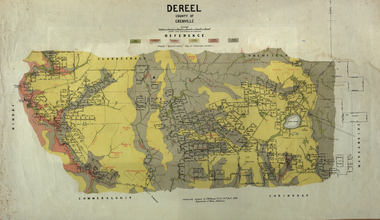
Map, Dereel, County of Grenville, 1890, 1890
... ...crown lands department......Crown Lands Department...Krause Crown Lands Department ...Dereel is in western Victoria.Geological map of Dereel in the County of Grenville featuing six colours (predominantly grey and yellow). WGS 84 Centroid Lat: 37 degrees 48 feet 50 inches S Long:143 degrees 42 feet 10 inches S N-S: 6.4 km E-W: 15.2 km dereel, ferdinand krause, crown lands department, plan -
 Flagstaff Hill Maritime Museum and Village
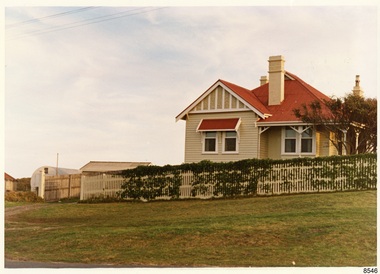
Photograph - Historical, Flagstaff Hill, Harbourmaster’s Quarters, 1970s
... ...Lands Department...On the left of the red roofed residence are iron buildings used, at the time, by the Lands Department. The photograph's paper has the printer's watermark on the back. ...Label on the back: "WOODEN RESIDENCE TO THE EAST OF THE PROPERTY / The gun emplacements are immediately behind, and the iron huts to the left rear of the residence are used by the Lands Department who plan to vacate, for other premises."...On the left of the red roofed residence are iron buildings used, at the time, by the Lands Department. The photograph's paper has the printer's watermark on the back. ...The photograph shows a cottage, Harbourmaster’s quarters that still stands on the east of the Lady Bay Lighthouse and Historic Precinct at Flagstaff Hill in Warrnambool. The name was changed to the Lighthouse Lodge, and today guests can stay at the property. This photograph, a print, is one of a set of five that show the site of Flagstaff Hill. It is presumed to have been taken by John Lindsay, Founding Director of Flagstaff Hill Maritime Museum and Village. One of the photographs in the set has the pencil inscription "Photo J Lindsay". It was taken in the early 1970s during the initial stages of the development of Flagstaff Hill as a Museum and Maritime Village. The photographs belonged to the donor's grandparents, who lived in the Warrnambool district of Allansford/Naringal. The photograph is a record of the site and surrounds of Flagstaff Hill Maritime Museum and Village before its development and opening in 1975. It shows the cottage on the east of the Lighthouse Complex,. The building is now known as Lighthouse Lodge. The photograph is significant for recording the location and condition of the residence on the Hill.Coloured photograph, glassy print, one of a set of five. Photograph shows the cream timber cottage, Harbourmaster’s quarters to the east of the lighthouse complex at Flagstaff Hill, Warrnambool. On the left of the red roofed residence are iron buildings used, at the time, by the Lands Department. The photograph's paper has the printer's watermark on the back. The early 1970s photograph is presumed to have been by John Lindsay, Warrnambool.Label on the back: "WOODEN RESIDENCE TO THE EAST OF THE PROPERTY / The gun emplacements are immediately behind, and the iron huts to the left rear of the residence are used by the Lands Department who plan to vacate, for other premises."flagstaff hill, flagstaff hill maritime museum and village, warrnambool, maritime museum, maritime village, great ocean road, shipwreck coast, 1970s, photograph, flagstaff hill site, john lindsay, cannon emplacement, residence, wooden residence, timber residence, iron huts, lands department, light keeper -
 Ringwood and District Historical Society
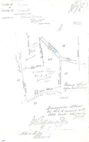
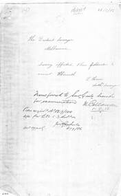
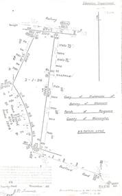
Document - Copy of Lands Department Field Notes - Ringwood, Victoria, Field Notes 76631 Surveyed in 1878
... Copy of Lands Department Field Notes - Ringwood, Victoria...Field Notes 76631 Surveyed in 1878 Document Copy of Lands Department Field Notes - Ringwood, Victoria ...Foolscap size photocopy of survey map with handwritten notations. References include Canterbury Road, Bungalook Road, Dandenong Creek, Frank Miller, H.K. Kemps, Leech. Notations signed and dated January 1878 and May 1879. -
 Ringwood and District Historical Society
Document - Copy of Lands Department Field Notes - Ringwood, Victoria, Field Notes 86.87/108 - Survey O.P. R72A dated August 1886 by Surveyor, L. Thorn
... Copy of Lands Department Field Notes - Ringwood, Victoria...Document Copy of Lands Department Field Notes - Ringwood, Victoria ...Foolscap size photocopies of survey maps with handwritten notations. -
 Ringwood and District Historical Society
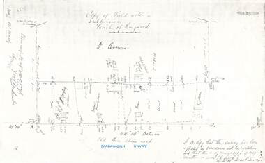
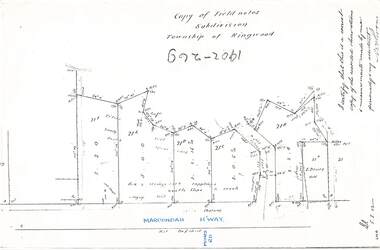
Document - Copy of Lands Department Field Notes - Parish of Ringwood, Victoria, Field Notes 88-9/276 - Part of O.P. R72C surveyed 12.10.1888
... Copy of Lands Department Field Notes - Parish of Ringwood, Victoria...R72C surveyed 12.10.1888 Document Copy of Lands Department Field Notes - Parish of Ringwood, Victoria ...Foolscap size photocopy of survey map with handwritten notations. References include - Commencing at bank of creek, Bearing over fence read 134"12', post and rail fence, old round post, Quigley, WB house iron roof, paling & shingle roof, garden, Forshaw formerly Hoare, D Brown, stable & shed, slats & palings, orchard, Occupied by Forshaw, 4 rooms WB Cottage iron roof, Sherbin, Old three chain road, Maroondah Highway, Molloy's corner, I certify that this survey has been effected in accordance with the regulations and that this is a correct copy of my results (signed) - Reed, Assistant Surveyor, 12.10.88. -
 Ringwood and District Historical Society
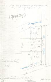
Document - Copy of Lands Department Field Notes - Subdivision of Police Reserve at Ringwood, County of Mornington, Field Notes 1900/293 - Part of O.P. R72C surveyed 1900
... Copy of Lands Department Field Notes - Subdivision of Police Reserve at Ringwood, County of Mornington...R72C surveyed 1900 Document Copy of Lands Department Field Notes - Subdivision of Police Reserve at Ringwood, County of Mornington ...Foolscap size photocopy of survey map with handwritten notations. References include Mount Dandenong Road, Dublin Road, Patterson Street, Melbourne to Lilydale railway line, I certify that this is a correct copy of recorded observations made by my assistant (signed) W. Thorn, Staff Surveyor. -
 Ringwood and District Historical Society
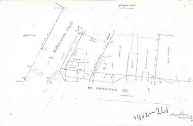
Document - Copy of Lands Department Field Notes - Ringwood, Victoria, Field Notes 1902/261 - Part of O.P. R72D surveyed 14.7.1902
... Copy of Lands Department Field Notes - Ringwood, Victoria...R72D surveyed 14.7.1902 Document Copy of Lands Department Field Notes - Ringwood, Victoria ...Foolscap size photocopies of survey maps with handwritten notations. -
 Ringwood and District Historical Society
Document - Copy of Lands Department Field Notes - Subdivision Township of Ringwood, Victoria, Field Notes 1902/269 - Part of O.P. R72D surveyed in 1902
... Copy of Lands Department Field Notes - Subdivision Township of Ringwood, Victoria...R72D surveyed in 1902 Document Copy of Lands Department Field Notes - Subdivision Township of Ringwood, Victoria ...Foolscap size photocopy of survey map with handwritten notations. References include Maroondah Highway, (opposite) Mines Road, Ti tree, Sandy soil, heath, spear grass, box & stringy bark sapplings, gentle slope to creek, E. Drury. I certify that this is a correct copy of the recorded observations and measurements made by me personally and my assistant (signed) W. Thorn. -
 Ringwood and District Historical Society
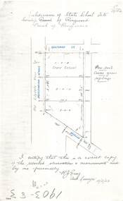
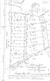
Document - Copy of Lands Department Field Notes - Subdivision of State School Site, Township of Ringwood, Victoria, Field Notes 1903/83 - Part of O.P. R72C Surveyed 13/2/1903
... Copy of Lands Department Field Notes - Subdivision of State School Site, Township of Ringwood, Victoria...R72C Surveyed 13/2/1903 Document Copy of Lands Department Field Notes - Subdivision of State School Site, Township of Ringwood, Victoria ...Foolscap size photocopy of survey map with handwritten notations. References include Everard Street, Old Lilydale Road (Maroondah Highway), Dublin Road, poor soil, coarse grass, saplings, I certify that this is a correct copy of the recorded observations & measurements made by me personally (signed) R.J. Gray Autorised Surveyor 13/2/03. -
 Ringwood and District Historical Society
Document - Copy of Lands Department Field Notes - Subdivision of Ringwood, Victoria, Field Notes 1904/188 - Part of O.P. R72D Surveyed 28.4.1904
... Copy of Lands Department Field Notes - Subdivision of Ringwood, Victoria...Document Copy of Lands Department Field Notes - Subdivision of Ringwood, Victoria ...Foolscap size photocopy of survey map with handwritten notations. References include Mount Dandenong Road to Lilydale, M. Dickson (sold), Church of England, P. Schonnenberger, Helen Lindsay, W.B. iron roof & shingles, I certify that this is a correct copy of the recorded observations and measurement made by me and my assistant (signed) W. Thorn 12/5/04 -
 Ringwood and District Historical Society
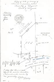
Document - Copy of Lands Department Field Notes - Survey of Extension to Recreation Reserve, Township of Ringwood, Victoria, Field Notes 1907/436 - Part of O.P. R72D Surveyed 6.8.1907
... Copy of Lands Department Field Notes - Survey of Extension to Recreation Reserve, Township of Ringwood, Victoria...Document Copy of Lands Department Field Notes - Survey of Extension to Recreation Reserve, Township of Ringwood, Victoria ...Foolscap size photocopy of survey map with handwritten notations. References include New Lilydale Road 3 chains wide (Mount Dandenong Road), Silurian, undulating, poor grass, Corner cut off to allow for road in future subdivision, Old recreation reserve, (circled area) oval now in use, A. Gisler, I certify that this is a correct copy of the recorded observations & measurements made by me personally (signed) R.J. Gray 6/8/07. -
 Ringwood and District Historical Society
Document - Copy of Lands Department Field Notes - Subdivision Sec E, Township of Ringwood, Victoria, Field Notes 1908/670 - Survey O.P. R72E dated November 1908
... Copy of Lands Department Field Notes - Subdivision Sec E, Township of Ringwood, Victoria...Document Copy of Lands Department Field Notes - Subdivision Sec E, Township of Ringwood, Victoria ...Foolscap size photocopies of survey maps with handwritten notations. -
 Ringwood and District Historical Society
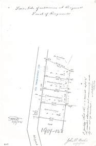
Document - Copy of Lands Department Field Notes - Parish of Ringwood, Victoria, Field Notes 1909/174 - Part of O.P. R72D surveyed 12.3.1909
... Copy of Lands Department Field Notes - Parish of Ringwood, Victoria...R72D surveyed 12.3.1909 Document Copy of Lands Department Field Notes - Parish of Ringwood, Victoria ...Foolscap size photocopy of survey map with handwritten notations. References include Mount Dandenong Road, pathway, 2 room house, scillion, shed, WC, 17C sold, Cr lands, orchard, 17E sold, Township boundary, I certify that these field notes are a true copy of the actual results of observations and measurements taken by me on the ground (signed) D. Barker 12.3.09. -
 Ringwood and District Historical Society
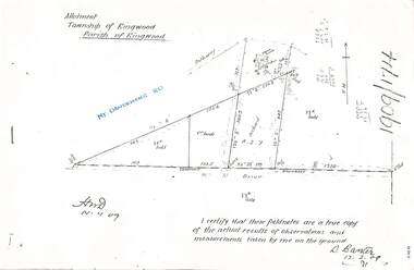
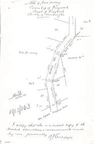
Document - Copy of Lands Department Field Notes - Township of Ringwood, Victoria, Field Notes 1913/163 - Part of O.P. R72D surveyed April 1913
... Copy of Lands Department Field Notes - Township of Ringwood, Victoria...R72D surveyed April 1913 Document Copy of Lands Department Field Notes - Township of Ringwood, Victoria ...5612b Foolscap size photocopy of survey map with handwritten notations. References include Mines Road, New Lilydale Road (Maroondah Highway), (area) Held for mining, Recreation Reserve, Sec D, Sec E, I certify that this is a correct copy of the recorded observations & measurements made by me personally (signed) R.J. Gray 2/4/13. -
 Ringwood and District Historical Society
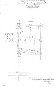
Document - Copy of Lands Department Field Notes - Parish of Ringwood, Victoria, Field Notes 1917/137 - Part of O.P. R72 - Allotment 10, surveyed June 1917
... Copy of Lands Department Field Notes - Parish of Ringwood, Victoria...R72 - Allotment 10, surveyed June 1917 Document Copy of Lands Department Field Notes - Parish of Ringwood, Victoria ...5613b Foolscap size photocopy of survey map with handwritten notations. References include Knight's land, Wantirna Road, Canterbury Road, house, wirenetted, orchard, grass paddock, I certify that these notes are a true copy of observations and measurements taken on the ground by me (signed) H.W. Moore 5/6/17. -
 Ringwood and District Historical Society
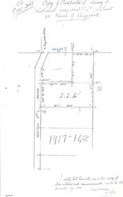
Document - Copy of Lands Department Field Notes - Parish of Ringwood, Victoria, Field Notes 1917/148 - Part of O.P. R72 - Crown Allotment 10, surveyed June 1917
... Copy of Lands Department Field Notes - Parish of Ringwood, Victoria...R72 - Crown Allotment 10, surveyed June 1917 Document Copy of Lands Department Field Notes - Parish of Ringwood, Victoria ...5614b Foolscap size photocopy of survey map with handwritten notations. References include Wantirna Road, to Ringwood Station, Reilly Street, J. Marshall, fence to be erected on boundary, I certify that these notes are a true copy of observations and measurements made on the ground by me (signed) H.W. Moore 22/6/17. -
 Ringwood and District Historical Society
Document - Copy of Lands Department Field Notes - Parish of Ringwood, Victoria, Field Notes - OP34838 - surveyed in 1919 by D. Barker
... Copy of Lands Department Field Notes - Parish of Ringwood, Victoria...Document Copy of Lands Department Field Notes - Parish of Ringwood, Victoria ...5615b Foolscap size photocopy of survey map with handwritten notations. References include Braeside Avenue, Mount Dandenong Road, Rosedale Court, Railway Avenue, cyclone fence, Sec A, WB house, old tennis court netted, stable, old shed, tank stand, orchard, Township Boundary, netting fence, Railway fence, Ringwood to Lilydale Railway, I certify that these fieldnotes are a true copy of the actual results of observations & measurements taken by me on the ground (signed) D. Barker (1919). -
 Ringwood and District Historical Society
Document - Copy of Lands Department Field Notes - Parish of Ringwood, Victoria, Field Notes - 1928/453 - Part of OP R72C Surveyed on 17.11.1928
... Copy of Lands Department Field Notes - Parish of Ringwood, Victoria...Document Copy of Lands Department Field Notes - Parish of Ringwood, Victoria ...5616b Foolscap size photocopy of survey map with handwritten notations. References include Whitehorse Road, Mines Road, Wilson Street, Rupert Street, New Road (Braeside Avenue), Section E, Allot 31 sold, Allot 32 sold, Recreation Reserve, Allot 25 sold, Allot 29 sold, hedge, spikes, links on line from each corner, I hereby certify that these field notes were prepared from actual observations and measurements made by me or under my supervision on the ground and in accord with regulations (signed) Authorised Surveyor 17/11/28. -
 Ringwood and District Historical Society
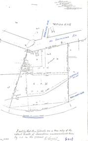
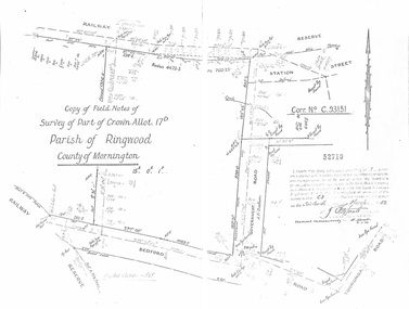
Document - Copy of Lands Department Field Notes - Parish of Ringwood, Victoria, Field Notes - Part of Crown Allotment 17D Surveyed 1952 (Amended in 1953)
... Copy of Lands Department Field Notes - Parish of Ringwood, Victoria...Document Copy of Lands Department Field Notes - Parish of Ringwood, Victoria ...5616b Double foolscap size photocopy of survey map with handwritten notations. References include Corr no. C.93151, Railway Reserve, Station Street, Bedford Road, multiple post & wire fences, multiple galv iron pipes put in, Government Road (Hill Street), Tooronga Road, multiple recent pegs found, Certification 52710 by J. Fitzgerald Licensed Surveyor 17/3/1952. -
 Ringwood and District Historical Society
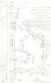
Document - Copy of Lands Department Field Notes - Parish of Ringwood, Victoria, Field Notes 55114 Survey of Allotment by J.D. Sherwood in 1955
... Copy of Lands Department Field Notes - Parish of Ringwood, Victoria...Document Copy of Lands Department Field Notes - Parish of Ringwood, Victoria ...5618b Foolscap size photocopy of survey map with handwritten notations. References include Railway (Reserve), Education Department, A-B Datum 117degrees20', Bedford Road, Certification by J.D. Sherwood Licensed Surveyor 23/11/1955. -
 Bendigo Historical Society Inc.
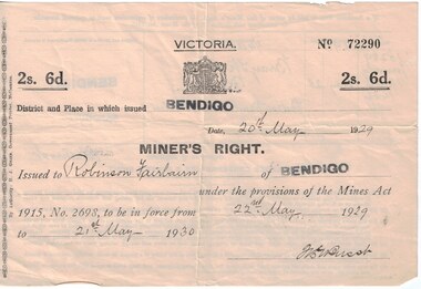
Document - Mining in Bendigo, 1909 to 1939
... ...victorian lands department and closer settlement commission...Documents related to Mining in Bendigo, purchase of a property. 8663.3a Front of Miners Right issued to Robinson Fairbairn 8663.3b Back of Miners Right issued to Robinson Fairbairn 8663.3c Valuation from Shire of Marong, 14 Bray St., California Gully 8663.3d Receipt from the Lands Department and Closer settlement Commission 8663.3e Receipt from the Lands Department and Closer settlement Commission 8663.3f Receipt from the Lands Department and Closer settlement Commission 8663.3g Receipt from the Lands Department 8663.3h Receipt from Albert E. ...History House 11 Mackenzie Street Bendigo goldfields BHS Collection history mining robinson fairbairn collection miners right victorian lands department and closer settlement commission albert e brown land and stock agent Documents related to Mining in Bendigo, purchase of a property. 8663.3a Front of Miners Right issued to Robinson Fairbairn 8663.3b Back of Miners Right issued to Robinson Fairbairn 8663.3c Valuation from Shire of Marong, 14 Bray St., California Gully 8663.3d Receipt from the Lands Department and Closer settlement Commission 8663.3e Receipt from the Lands Department and Closer settlement Commission 8663.3f Receipt from the Lands Department and Closer settlement Commission 8663.3g Receipt from the Lands Department 8663.3h Receipt from Albert E. ...BHS CollectionDocuments related to Mining in Bendigo, purchase of a property. 8663.3a Front of Miners Right issued to Robinson Fairbairn 8663.3b Back of Miners Right issued to Robinson Fairbairn 8663.3c Valuation from Shire of Marong, 14 Bray St., California Gully 8663.3d Receipt from the Lands Department and Closer settlement Commission 8663.3e Receipt from the Lands Department and Closer settlement Commission 8663.3f Receipt from the Lands Department and Closer settlement Commission 8663.3g Receipt from the Lands Department 8663.3h Receipt from Albert E. Brown Land and Stock Agenthistory, mining, robinson fairbairn collection, miners right, victorian lands department and closer settlement commission, albert e brown land and stock agent -
 Whitehorse Historical Society Inc.
Document, Crown Grant Register, 10/05/1999
... ...Victoria. Lands Department...Crown Grant Register - General Law - Parish of Nunawading, 1854 - 1858. Lands Department plan of Parish, 1864....Lands Department plan of Parish, 1864. Crown Grant Register Document Document ...Crown Grant Register - General Law - Parish of Nunawading, 1854 - 1858. Lands Department plan of Parish, 1864.land settlement, victoria. lands department, blood, robert, blood, thomas, burrell, charles, clisby, william, cook, charles, cousens, james, dickensen, william, harding, william, hedding, william, holland, john, jones, william, kefford, richard, lobb, john, morgan, robert rowland, morton, william, o'conner, patrick, orr, joseph, polak, nelson, riley, patrick, smith, l l dr, tranter, william, whitman, francis, williams, william, wilks, joseph, wilson, william, wilton, edward -
 Federation University Historical Collection
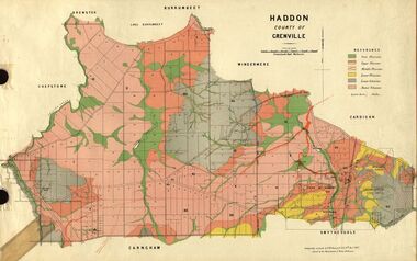
Plan, Haddon, County of Grenville, 1887, 1889
... ...Crown Lands Department Melbourne......Crown Lands Department Melbourne...Krause Crown Lands Department Melbourne Ferdinand M. Krause Crown Lands Department Melbourne ...Ferdinand Krause taught at the Ballarat School of MinesGeological Map of Haddon in the County of Grenville surveyed by Ferdinand Krause. haddon, grenville, krause, ferdinand krause, cgt, lake burrumbeet, windermere, chepstowe, bailies creek, snake valley lead, nentingbool preemptice right, cardigan state forest, haddon state forest -
 Whitehorse Historical Society Inc.
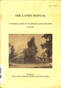
Manual - Government (Lands Dept), Royal Historical Society of Victoria, The Lands Manual - A Finding Guide to Victorian Land Records 1836 - 1983, March 1989
... Lands...Victoria. Department of Crown Lands and Survey...The manual documents the archives of the Department of Crown Lands and Survey (Lands Department) and explains how they can be used for historical research....The manual documents the archives of the Department of Crown Lands and Survey (Lands Department) and explains how they can be used for historical research. ...The manual documents the archives of the Department of Crown Lands and Survey (Lands Department) between 1836 to 1983 and explains how they can be used for historical research.The manual documents the archives of the Department of Crown Lands and Survey (Lands Department) and explains how they can be used for historical research.The manual documents the archives of the Department of Crown Lands and Survey (Lands Department) between 1836 to 1983 and explains how they can be used for historical research.crown lands, victoria. department of crown lands and survey -
 Ringwood and District Historical Society
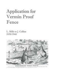
Document - Department of Lands and Survey, Wire Netting Branch, Melbourne, Victoria, Application for Vermin-Proof Fence Certificate - L.J. Mills vs John Collins, Grandview Grove, Ringwood, Victoria - 1939
... Department of Lands and Survey, Wire Netting Branch, Melbourne, Victoria...File includes 1939 and 1940 detailed property inspection reports by Vermin and Noxious Weeds Branch, Lands Department, Lilydale, describing land use in the area and signs of vermin activity. ...The adjoining land on west and north boundaries is owned by Mrs Linda Collins and John Collins resp of Brysons Road East Ringwood. - Jas H Allison (Inspector, Vermin and Noxious Weeds Branch, Lands Department, Lilydale)."...File includes 1939 and 1940 detailed property inspection reports by Vermin and Noxious Weeds Branch, Lands Department, Lilydale, describing land use in the area and signs of vermin activity. ...Photocopied file of corresponence and documentation relating to a claim by L.J. Mills, Nurseryman, that adjoining property owner, J. Collins, Farmer, assists with replacement of a vermin proof wire netting dividing fence destroyed by 1939 bushfire. File includes 1939 and 1940 detailed property inspection reports by Vermin and Noxious Weeds Branch, Lands Department, Lilydale, describing land use in the area and signs of vermin activity. Application approved 18th April, 1940. Appeal lodged by Mr Collins disallowed in May, 1940. File closed June, 1940 with Departmental suggesion that Mr Mills consider further legal action through a Solicitor as fence had still not been wire-netted. TRANSCRIPTS: Vermin & Noxious Weeds Inspection Reports "19/9/1939 (To) Superintendent (Department of Lands and Survey, Melbourne) Re L.J. Mills application for Vermin Proof Fence. I called on Mr Mills yesterday 18th instant in connection with this matter. Mr Mills has a flower farm and claims that rabbits and hares are damaging his flowers. He showed me a bed of carnations which he stated were being damaged by rabbits. There was evidence of some leaves being nipped off, but I am unable to say whether this is due to rabbits or grubs. Very little if any real damage is being done. The property is netted on the east and south boundary and on half the north and west boundary. The surrounding country is undlating and fairly steep in places. The land to the east across Grandview Avenue (sic) is all planted out in old established orchards and well cultivated. Cleared grass land adjoins the south boundary and bush land adjoins the north and west boundaries. I walked over a large area surrounding Mr Mills land and never saw any rabbits or hares or any indications of rabbits. This locality is not rabbit infested and very little wire netting is being used. I do not consider that a vermin proof fence is necessary between these allotments. - Jas H Allison (Inspector, Vermin and Noxious Weeds Branch, Lands Department, Lilydale)." Follow up report following renewal of application for Certificate by Mr Mills, citing rabbits causing considerable damage to his flowers. He laid poison and obtained 9 carcases and stated that there is evidence of rabbit infestation from the adjoing land. "19/3/1940 (To) Mr Hannah (Superintendant, Department of Lands and Survey, Melbourne) Re L.J. Mills, Grandview Grove Ringwood, Lot 4 Grandview Estate Pt CG20 Ph of Warrandyte. I interviewed Mr Mills at his home on 15th inst. He showed me carcases of rabbits which he stated had been poisoned on his land. In places young plants had been nipped off apparently by rabbits. I made an inspection of adjoining properties and found one live burrow close to Mr Mills northern boundary. There were scratches and other evidence of rabbits on land north and west of Mr Mills property. In view of the present evidence of rabbits I consider that a vermin proof fence is now necessary to protect the flowers grown by Mr Mills. His land is netted on whole of east and south boundary and half way on west and north boundary. The adjoining land on west and north boundaries is owned by Mrs Linda Collins and John Collins resp of Brysons Road East Ringwood. - Jas H Allison (Inspector, Vermin and Noxious Weeds Branch, Lands Department, Lilydale)." -
 Bendigo Military Museum
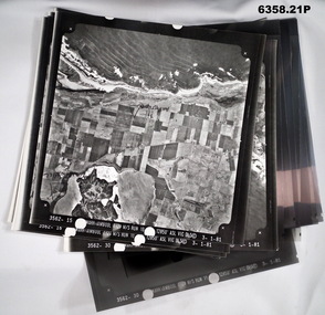
Photograph - Aerial Photography - Mohogany Ship Search Warrnambool Victoria, Victorian Lands Department, 3.1.1981
... Victorian Lands Department...Aerial Photography - Mohogany Ship Search Warrnambool Victoria Photograph Aerial Photography - Mohogany Ship Search Warrnambool Victoria Victorian Lands Department ...These Victorian Lands Dept Aerial Photographs were acquired by the Army Survey Regiment to help locate a Mohogany Ship wreck near Warrnambool Victoria as part of a unit Regimental Training ExerciseSeven Aerial photographic Prints and Film Negatives and positives of the same images. Images are Numbered 3562- 15,16,17,18,19, 29 and 30.royal australian survey corps, rasvy, fortuna, army survey regiment, army svy regt, asr -
 Bendigo Military Museum
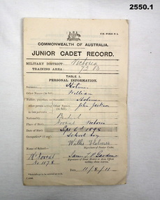
Administrative record - SERVICE RECORDS, 1) Commonwealth of Australia et al, 1) 11.8.1911; .2) 9.5.1919; .3) 10.12.1942;
... ....2) Crown Lands Department...Administrative record SERVICE RECORDS .1) Commonwealth of Australia .2) Crown Lands Department .3) Australian Military Forces ...Part of WILLIAM HOLMES Collection. Refer Cat No 2548.2P for his service details. .1) Junior Cadet Record for WILLIAM HOLMES, folded, dated 11.8.1911. .2) Discharged Soldiers Qualification Certificate approving WILLIAM HOLMES for mixed farming dated 9.5.1919. .3) Volunteer Defence Corps certificate detailing WILLIAM HOLMES' service dated 10.12.1942.documents - army records, documents - certificates -
Federation University Historical Collection
Plan, Crown Lands Department Melbourne, Parish of Clarkesdale, County of Grenville
... Crown Lands Department Melbourne...Parish of Clarkesdale, County of Grenville Plan Crown Lands Department Melbourne ...Geolgical plan.clarkesdake, berringa, staffordshire reef, piggoreet -
 Wycheproof & District Historical Society Inc.
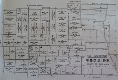
Bunguluke Map, Bunguluke District In 1923, 27.2.1923
... The Lands Department and Survey, Melbourne by W.J. Butson...Bunguluke District In 1923 Bunguluke Map The Lands Department and Survey, Melbourne by W.J. Butson ...By 1881 Bunguluke was a small settlement as recorded, December 5, in the Charlton "Mercury". It reports that in that year Draper's Store, Hotel and Post Office and residence at Bunguluke North was totally destroyed by fire. For years now there has been little sign of community life with houses few and far between and acreages have gone into larger holdings. The map references land blocks and owners for that era.This important map shows the local land ownership and local features that existed in 1923. This is a photocopied black and white map of Bunguluke in the County of Kara Kara, Number L5149. Marked - Photo Lithographed by W.J. Butson 27.2.1923. The details include numbers of allotments, property owners, roads, rivers. The boundaries marked are the Parish of Jeruk, Parish of Wycheproof, Parish of Cooroopajerrup. Wycheproof township location is shown with the Scale of Chains. Bunguluke maps for other years are also in the collection.map, bunguluke, jeruk, wycheproof, cooroopajerrup