Showing 16 items matching " lightning hill line of reef"
-
 Bendigo Historical Society Inc.
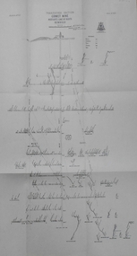
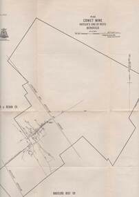
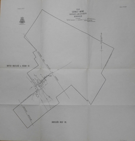
Map - COMET MINE - TRANSVERSE SECTION COMET MINE
... ... Lightning Hill Line of Reef...History House 11 Mackenzie Street Bendigo goldfields MINING Hustler's Line of Reefs Transverse Section of Comet Mine Bulletin No 33 Plate No XXV Lightning Hill Line of Reef Geological Survey of Victoria Transverse section of the Comet Mine on the Hustler's Line of Reef Bulletin No 33, Plate No XXV signed by H. ...Transverse section of the Comet Mine on the Hustler's Line of Reef Bulletin No 33, Plate No XXV signed by H. A. Whitdon, Underground Survey Office Bendigo September,1913. Map shows depth of the different levels, the type of stone and shaft about 2020 deep. A number of smaller drawings on the side. Reference explaining the different types of stone, etc. Geological Survey of Victoriamining, hustler's line of reefs, transverse section of comet mine bulletin no 33 plate no xxv, lightning hill line of reef -
 Bendigo Historical Society Inc.
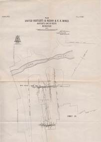
Map - STRUGNELL COLLECTION: UNITED HUSTLER'S & REDAN & K.K.MINES, September 1913
... Map, Hustler's Line of Reefs, Bendigo, United Hustler's & Redan, & K.K.Mines, Plate No.XXV11 (27), Long Gully, Lightning Hill Line of Reefs at surface.Dated September 1913 //Bulletin 33.Signed H.A.Whitelaw....History House 11 Mackenzie Street Bendigo goldfields MAP Bendigo united hustler's redan k.k.mines Underground Survey Office,Bendigo, Map, Hustler's Line of Reefs, Bendigo, United Hustler's & Redan, & K.K.Mines, Plate No.XXV11 (27), Long Gully, Lightning Hill Line of Reefs at surface.Dated September 1913 //Bulletin 33.Signed H.A.Whitelaw. ...Map, Hustler's Line of Reefs, Bendigo, United Hustler's & Redan, & K.K.Mines, Plate No.XXV11 (27), Long Gully, Lightning Hill Line of Reefs at surface.Dated September 1913 //Bulletin 33.Signed H.A.Whitelaw.Underground Survey Office,Bendigo,map, bendigo, united hustler's, redan, k.k.mines -
 Bendigo Historical Society Inc.
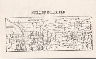
Map - BENDIGO GOLDFIELD MAP
... Line, Lines of Reefs and mines are shown. Dept. of Mines, Victoria printed on the map. Shows reefs from Bird's Line of Reefs to Lightning Hill Line of Reef....Reefs Dept. of Mines Victoria Two not very clear copies of the Bendigo Goldfield Map. Streets, Railway Line, Lines of Reefs and mines are shown. Dept. of Mines, Victoria printed on the map. Shows reefs from Bird's Line of Reefs to Lightning Hill ...Two not very clear copies of the Bendigo Goldfield Map. Streets, Railway Line, Lines of Reefs and mines are shown. Dept. of Mines, Victoria printed on the map. Shows reefs from Bird's Line of Reefs to Lightning Hill Line of Reef.map, bendigo, goldfields, bendigo goldfield map, lines of reefs, dept. of mines victoria -
 Bendigo Historical Society Inc.
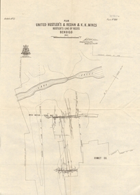
Map - UNITED HUSTLER'S & REDAN & K. K. MINES - PLAN OF UNITED HUSTLER'S & REDAN & K. K. MINES
... Mines on the Hustler's Line of Reefs Bulletin No 33 Plate No XXVII. Plan shows depth of levels, Long Gully, Hustler's Line of Reefs, Lightning Hill Line of Reefs and approximate Boundary of Lease. ...Mines Long Gully Hustler's Line of Reefs Lightning Hill Line of Reefs Comet Co H S Whitelaw Geological Survey of Victoria Underground Survey Office Plan of the United Hustler's & Redan & K. ...Plan of the United Hustler's & Redan & K. K. Mines on the Hustler's Line of Reefs Bulletin No 33 Plate No XXVII. Plan shows depth of levels, Long Gully, Hustler's Line of Reefs, Lightning Hill Line of Reefs and approximate Boundary of Lease. Also mentions Comet Co. Geological Survey of Victoria emblem and signed by H S Whitelaw, Underground Survey Office Bendigo September 1913.mining, parish map, united hustler's & redan & k. k. mines, long gully, hustler's line of reefs, lightning hill line of reefs, comet co, h s whitelaw, geological survey of victoria, underground survey office -
 Bendigo Historical Society Inc.
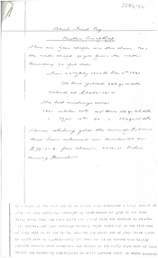
Document - ALBERT RICHARDSON COLLECTION: BLACK FOREST COMPANY
... line of reef. The Black Forest mine was situated one mile north of the Eaglehawk Post Office. To the west was the South New Moon on the Garden Gully line of reef and to the east was the Lightning Hill line of reef worked by open cutting to a depth of over 100 ft by Pascoe and Simonds. ...line of reef. The Black Forest mine was situated one mile north of the Eaglehawk Post Office. To the west was the South New Moon on the Garden Gully line of reef and to the east was the Lightning Hill line of reef worked by open cutting to a depth of over 100 ft by Pascoe and Simonds. ...Five page handwritten and typed document with information about the Black Forest Gold Mine on the Hustler's line of reef. The Black Forest mine was situated one mile north of the Eaglehawk Post Office. To the west was the South New Moon on the Garden Gully line of reef and to the east was the Lightning Hill line of reef worked by open cutting to a depth of over 100 ft by Pascoe and Simonds. A party of Germans named 'Rothacker and Party', first worked the claim on the Black Forest mine approx. 1860. Other mines worked on the Hustler's line north of the Black Forest were: Martha Company. Johns and company and Meaner (unclear) and Co.bendigo, mining, black forest gold mine -
 Bendigo Historical Society Inc.
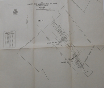
Map - HUSTLER'S REEF & HUSTLER'S REEF NO 1 MINES - PLAN OF THE HUSTLER'S REEF & HUSTLER'S REEF NO 1 MINES
... Reef No 1 Mines... Hustler's Line of Reefs Lightning Hill Line of Reefs...Line of Reefs, Bendigo Bulletin No 33, Plate No XIV. No 8 connecting No 10 (Hustler's Reef), No 11 connecting No 13 (Hustler's Reef), No 13 (Hustler's Reef No 1) connecting No 15 (Hustler's Reef) and No 10 Hustler's Reef No 1 rise to Comet Mine. Map shows different levels in relation to the two shafts, the lines of the Hustler's Line of Reefs and the Lightning Hill...History House 11 Mackenzie Street Bendigo goldfields MINING Parish Map Hustler's Reef & Hustler's Reef No 1 Mines Hustler's Line of Reefs Lightning Hill Line of Reefs Comet Co. H A Whitelaw Underground Survey Office Bendigo Geological Survey of Victoria Plan of the Hustler's Reef & Hustler's Reef No 1 Mines on the Hustler's Line of Reefs, Bendigo Bulletin No 33, Plate No XIV. ...Plan of the Hustler's Reef & Hustler's Reef No 1 Mines on the Hustler's Line of Reefs, Bendigo Bulletin No 33, Plate No XIV. No 8 connecting No 10 (Hustler's Reef), No 11 connecting No 13 (Hustler's Reef), No 13 (Hustler's Reef No 1) connecting No 15 (Hustler's Reef) and No 10 Hustler's Reef No 1 rise to Comet Mine. Map shows different levels in relation to the two shafts, the lines of the Hustler's Line of Reefs and the Lightning Hill Line of Reefs, the approximate Boundary of Lease and the Comet Co., the adjoining lease. Table on the left shows the levels and their depths of the two mines. Signed by H A Whitelaw, Underground Survey Office, Bendigo, September 1913. Geological Survey of Victoria emblem. mining, parish map, hustler's reef & hustler's reef no 1 mines, hustler's line of reefs lightning hill line of reefs, comet co., h a whitelaw, underground survey office bendigo, geological survey of victoria -
 Bendigo Historical Society Inc.
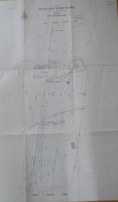
Map - HUSTLER'S ROYAL RESERVE NO 2 MINE - PLAN OF THE HUSTLER'S ROYAL RESERVE NO 2 MINE
... Plan shows the Hustler's Royal Reserve No 2 (Main Shaft), Hustler's Royal Reserve No 2 (Park Shaft.), the Royal Hustler's, the Imperial Hustler's and the Extended Hustler's Freehold on the Hustler's Line of Reefs. Also mentioned is the Lightning Hill Line of Reefs. ...History House 11 Mackenzie Street Bendigo goldfields MINING Parish Map Hustler's Royal Reserve No 2 Mine Royal Hustler's Imperial Hustler's Extended Hustler's Freehold Geological Survey of Victoria H Herman W Dickson The Hon J Drysdale Brown h Whitdan Hustler's Line of Reefs Lightning Hill Line of Reefs Plan of the Hustler's Royal Reserve No 2 Mine Bulletin No 33, Plate No V. ...Plan of the Hustler's Royal Reserve No 2 Mine Bulletin No 33, Plate No V. Plan shows the Hustler's Royal Reserve No 2 (Main Shaft), Hustler's Royal Reserve No 2 (Park Shaft.), the Royal Hustler's, the Imperial Hustler's and the Extended Hustler's Freehold on the Hustler's Line of Reefs. Also mentioned is the Lightning Hill Line of Reefs. Map shows some of the levels, approximate boundary of lease and the boundary of Lease No 8892 and 8897. There are also street names and the locations of jail, lagoons, Post Office, Rosalind Park and the State School, High School and Continuation School. Geological Survey of Victoria emblem. H. Herman Director, W. Dickson, Secretary of Mines and The Hon. J. Drysdale Brown MLC, Minister of Mines. Signed by zh Whitdan, Underground Survey Office, Bendigo, September 1913.mining, parish map, hustler's royal reserve no 2 mine, royal hustler's, imperial hustler's, extended hustler's freehold, geological survey of victoria, h herman, w dickson, the hon j drysdale brown, h whitdan, hustler's line of reefs, lightning hill line of reefs -
 Bendigo Historical Society Inc.
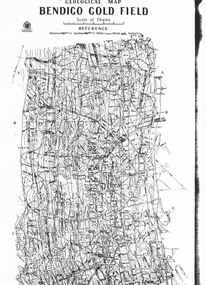
Map - LONG GULLY HISTORY GROUP COLLECTION: GEOLOGICAL MAP - BENDIGO GOLD FIELD
... History House 11 Mackenzie Street Bendigo goldfields BENDIGO History long gully history group The Long Gully History Group - Geological map - Bendigo Gold Field Mines Department H Herman Lightning Hill Line Hustlers Line Derby Line Paddy's Gully Line Garden Gully Line Deborah Line Sheepshead Line New Chum Line Nell Gwynne Line British and Foreign Line Napoleon Line Carshalton Line Thistle Line Christmas Line Lancashire Line Copy of a Geological Map of the Bendigo Gold Field. Map shows Lines of Reef ...Copy of a Geological Map of the Bendigo Gold Field. Map shows Lines of Reef, Anticlines, Synclines, Shafts, Alluvial Contours Gullies and some street names. Copy is hard to read. There are two pages.bendigo, history, long gully history group, the long gully history group - geological map - bendigo gold field, mines department, h herman, lightning hill line, hustlers line, derby line, paddy's gully line, garden gully line, deborah line, sheepshead line, new chum line, nell gwynne line, british and foreign line, napoleon line, carshalton line, thistle line, christmas line, lancashire line -
 Bendigo Historical Society Inc.
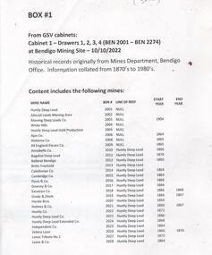
Document - MINING WARDEN COLLECTION
... line of reef located on, the start and end year. Information collated from 1870's to 1980's. Each mine's data is enclosed in a manilla folder within the box. Mines along the following reef lines are described: Huntly Deep Lead Whipstick Neilborough Drover Isabella Slaughteryard Blue Jacket Tyson One Tree Hill Flag Gravel Hill View Hill Lightning Hill Hustlers Ben # range from 2001 to 2274. ...line of reef located on, the start and end year. Information collated from 1870's to 1980's. Each mine's data is enclosed in a manilla folder within the box. Mines along the following reef lines are described: Huntly Deep Lead Whipstick Neilborough Drover Isabella Slaughteryard Blue Jacket Tyson One Tree Hill Flag Gravel Hill View Hill Lightning Hill Hustlers Ben # range from 2001 to 2274. ...Historical mining records originally from the Mining Warden's Office, Mines Department, Bendigo. A summary document lists the mine name; the BEN #; the line of reef located on, the start and end year. Information collated from 1870's to 1980's. Each mine's data is enclosed in a manilla folder within the box. Mines along the following reef lines are described: Huntly Deep Lead Whipstick Neilborough Drover Isabella Slaughteryard Blue Jacket Tyson One Tree Hill Flag Gravel Hill View Hill Lightning Hill Hustlers Ben # range from 2001 to 2274. Example of entry: Pascoe and Symmonds, Ben # 2217, Lightning Hill Reef, 1863-1885.bendigo, mining, mining warden records -
 Bendigo Historical Society Inc.
Document - Hustlers, Sheepshead and Deborah lines of reef
... line of reef...Sheepshead line of reef...Hustlers line of reef...Royal Hustlers Reserve mine...Hustlers Hill group of mines...Great Extended Hustlers...Hustlers Reef No. 1...Lightning...Bendigo gold mining Deborah line of reef Sheepshead line of reef Hustlers line of reef Royal Hustlers Reserve mine Hustlers Hill group of mines Great Extended Hustlers Hustlers Reef No. 1 Lightning Hill line Old Comet Collman and Tacchi Lansell's Comet North Deborah Central Deborah Dhrrpdhrsf linr og trrg New Red White and Blue Consolidated mine Big Blue Lansell's Bendigo Battery North Red White and Blue mine Albert Richardson Collection Five page document, hand written by Albert Richardson on lined foolscap and edited with cross-outs and insertions, . ...Albert Richardson was a mining historian who wrote widely on the mines of the Bendigo Goldfield. The park opposite the Goldmines Hotel in Marong Road, is named in his honour. Five page document, hand written by Albert Richardson on lined foolscap and edited with cross-outs and insertions, . The mines along the Hustlers line of reef and the Sheepshead line of reef are described. Mines listed on Hustlers line of reef: Fortuna Hustlers (1888 - 1913), shaft 2,240 feet at rear of Buckell and Jeffrey's offices; Royal Hustlers Reserve No. 2 - two shafts 'City" 860 feet, now covered by R.S.L. building Pall Mall, steel poppet legs 60 ft high and 'Park Shaft" at rear of Camp Hill School, 1,775 feet, steel poppet legs 60 feet high; Hustlers Hill Group first worked by Jonathan Harris in 1853 and bounded by Valentine, Anderson and Ironbark Creek to the north and Milroy Street to the east, one of first areas worked for quartz reefing. It with Garden Gully line west and Victoria Hill Ironbark, formed by far the richest cross section of the Bendigo Goldfield. Great Extended Hustlers (1865-1921) close to intersection of Anderson Street and Hustlers Road, mullock heap against road and shored up around shaft, steel poppet legs now at Wattle Gully mine, Chewton, large winding machine, air compressor south of shaft and 36 head crushing battery. Hustlers Reef (Old Hustlers) and Hustlers Reef No. 1, two shafts, main 2,210 feet, about 220 yards east of Moran Street and against Fenton Street. , No. 1 shaft 1,140 feet and about 155 yards east of Moran Street. Lansell's Comet, Lightining Hill line, 2.100 feet, on Comet Hill approx 70 yards west of Holmes Road, near Comet Creek, steel poppet legs. United Hustlers and Redan (1876-1918), main Redan, 1,830 feet about 155 yards west of Sandhurst Roead, in line with Comet Hill State School, this hill known as Redan Hill. North, or New Hustlers, once known as Agnew Hustlers, wooden poppet legs, south side, Kneebone Street, Eaglehawk. Derby line, Johnson's No. 3, South Johnson's (east shaft of Collman and Tacchi) 439 feet on west wide of Woods Street, south of Wetherall Street. Paddy's Gully Line, south to north, some shafts - Lansell's 'Sandhurst" ('Needle") Eaglehawk Road shaft 2,425 feet, about 50 yards east of Needle Loops, a brick square sided chimney with Cleopatra Needle top. British American, 789 feet, just south of Holdsworth Road. Collman and Tacchi, main shaft 2,588 feet, 60 yards west of Eaglehawk Road, California Gully. Deborah Line of Reef, The Deborah (1932-1954) shaft 2.017 feet, west of Adams Road and south of Abel Street, Quarry Hill. North Deborah (1937 - 1954) shaft 1,151 feet, Breen Street, Quarry Hill, steel poppet legs. Central Deborah (1939-1954) shaft 1,347 feet Sheepshead line of reef, Lansell's South Red, White and Blue, shaft 2,124 feet, north east of Bellevue Road and 220 yards east of Adams Road. The New Red, White and Blue Consolidated (Big Blue) main shaft 2,416 feet. Lansell's Bendigo Battery 105 head, north of 'Big Blue" on his freehold lease, commenced crushing on 24th February 1895. After closing was erected as the Showground's Industrial Hall, July 1926. North Red, White and Blue, burnt down February 1926, new company 1934, closed 1938. Document is part of the Albert Richardson Collection of Bendigo mining history. bendigo, gold mining, deborah line of reef, sheepshead line of reef, hustlers line of reef, royal hustlers reserve mine, hustlers hill group of mines, great extended hustlers, hustlers reef no. 1, lightning hill line, old comet, collman and tacchi, lansell's comet, north deborah, central deborah, dhrrpdhrsf linr og trrg, new red, white and blue consolidated mine, big blue, lansell's bendigo battery, north red, white and blue mine, albert richardson collection -
 Bendigo Historical Society Inc.
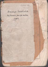
Booklet - Albert Richardson Collection: Bendigo Goldfield, MInes Department, Victoria 1936, 1936
... Line are further described with their date of formation, sill heights and area of claim. Fifty one page booklet. On front page: Bendigo Goldfield, issued by Geo Brown, Secretary for Mines, under the authority of The Hon. E.J. Hogan, M.L.A., Minister of Mines. Mines Department, Melbourne, Victoria, Australia, 1936.Content includes: historical information; recent development and future prospects, geology and lines of reef. Reef lines described are: Tysons, Lightning Hill ...Albert Richardson was an expert on the history of the Bendigo Goldfield. The Albert Richardson Park at Victoria Hill, is named in his honour. He was a prominent member of the Bendigo Historical Society. Fifty one page booklet. On front page: Bendigo Goldfield, issued by Geo Brown, Secretary for Mines, under the authority of The Hon. E.J. Hogan, M.L.A., Minister of Mines. Mines Department, Melbourne, Victoria, Australia, 1936.Content includes: historical information; recent development and future prospects, geology and lines of reef. Reef lines described are: Tysons, Lightning Hill, Hustlers, Derby, Paddy's Gully, Garden Gully, Deborah, Sheepshead, New Chum, Nell Gwynne, British and Foreign, Napoleon, Lancashire, Carshalton, Thistle, Christmas and Birds. On front cover 'Bendigo Goldfield, Geo Brown, Sec. for Mines, 1936' written in black pen. On first page 'A.Richardson, 29 Harrison Street, Bendigo' The booklet is annotated throughout by Albert Richardson, for example, the mines along the New Chum Line are further described with their date of formation, sill heights and area of claim.albert richardson, gold mining, goldfield, reef lines, 1936, mines department -
 Bendigo Historical Society Inc.
Map - STRUGNELL COLLECTION: HUSTLER'S LINE OF REEFS, BENDIGO
... Map, Hustler's Line of Reefs, Comet Mine, Plan, Plate No. XX111 (23).Lightning Hill Anticline at Surface, United Hustler's & Redan Co., Hustler's Reef Co. ...History House 11 Mackenzie Street Bendigo goldfields Bendigo Mines Hustler's line of reef Comet Mine Underground Survey Office, Bendigo. Map, Hustler's Line of Reefs, Comet Mine, Plan, Plate No. XX111 (23).Lightning Hill ...Map, Hustler's Line of Reefs, Comet Mine, Plan, Plate No. XX111 (23).Lightning Hill Anticline at Surface, United Hustler's & Redan Co., Hustler's Reef Co. Bulletin No 33 Signed H.A. Whitelaw Underground survey Office Bendigo September 1913Underground Survey Office, Bendigo.bendigo mines, hustler's line of reef, comet mine -
 Bendigo Historical Society Inc.
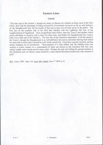
Document - TYSON'S LINE - EASTERN LINES
... Line... Lightning Hill... Tyson's... Isabella Mine... Ironstone Hill Reef...History House 11 Mackenzie Street Bendigo goldfields BHS Collection MINING Parish Map Tyson's Line Eastern Lines Hustler's New Chum Slaughteryard Line Lightning Hill Tyson's Isabella Mine Ironstone Hill Reef Nicholson Reef Mr Stevenson Aust Min Stand 1 June 1899 Typed carbon copy and typed copy of General notes on the lines East of the Hustlers. ...BHS CollectionTyped carbon copy and typed copy of General notes on the lines East of the Hustlers. Lines mentioned are: Hustler's, New Chum, Lightning Hill, Tysons, Slaughteryard, Isabella Mine, Ironstone Hill Reef, Nicholson Reef, on which a mine owned by a man named Stevenson mined a fair amount of gold. Ref. Anon; 1899. Spec. Ed. Aust. Min. Stand. June 1st 1899: p 61. Notes prepared by Albert Richardson.mining, parish map, tyson's line, eastern lines, hustler's, new chum, slaughteryard line, lightning hill, tyson's, isabella mine, ironstone hill reef, nicholson reef, mr stevenson, aust min stand 1 june 1899 -
 Bendigo Historical Society Inc.
Map - COMET MINE - PLAN OF COMET MINE
... Line Plan Belletin No 33 Plate No XXIII... Lightning Hill Anticline... Hustler's Anticline... United Hustler's & Redan Co... Hustler's Reef...Plan of the Comet Mine on the Hustler's Line of Reefs Bulletin No 33, Plate No XXIII. Map shows depths, Lightning Hill Anticline, Hustler's Anticline and approximate Lease Boundary. ...History House 11 Mackenzie Street Bendigo goldfields MINING Hustler's Line of Reefs Comet Line Plan Belletin No 33 Plate No XXIII Lightning Hill Anticline Hustler's Anticline United Hustler's & Redan Co Hustler's Reef Co H S Whitelaw Geological Survey of Victoria Plan of the Comet Mine on the Hustler's Line of Reefs Bulletin No 33, Plate No XXIII. ...Plan of the Comet Mine on the Hustler's Line of Reefs Bulletin No 33, Plate No XXIII. Map shows depths, Lightning Hill Anticline, Hustler's Anticline and approximate Lease Boundary. Signed by H. S. Whitelaw, Underground Survey Office Bendigo, September 1913. United Hustler's & Redan Co and Hustler's Reef Co also named on map. Geological Survey of Victoriamining, hustler's line of reefs, comet line plan belletin no 33 plate no xxiii, lightning hill anticline, hustler's anticline, united hustler's & redan co, hustler's reef co, h s whitelaw -
 Bendigo Historical Society Inc.
Document - HUSTLERS REEF - PLANS & SECTIONS TO ACCOMPANY BULLETIN NO 33
... Line of Reef, Bendigo by H S Whitelaw, by Authority: Albert J. Mullett, Government Printer, Melbourne. Plate No 1 to No 34. Mines mentioned: Fortuna Hustler's Mine, Hustler's Royal Reserve No 2 Mine, Hustler's Royal Reserve Mine Park Shaft, Great Extended Hustler's Mine, Hustler's Reef and Hustler's Reef No 1 Mines, Hustler's Reef Mine, Comet Mine, United Hustler's and Redan Mine, K. K. Mine, Hustler's Consols Mine, Fortuna Hustler's Mine. Department of Mines Geological Survey of Victoria 1914. Written on the back: Lightning Hill...Line of Reef, Bendigo by H S Whitelaw, by Authority: Albert J. Mullett, Government Printer, Melbourne. Plate No 1 to No 34. Mines mentioned: Fortuna Hustler's Mine, Hustler's Royal Reserve No 2 Mine, Hustler's Royal Reserve Mine Park Shaft, Great Extended Hustler's Mine, Hustler's Reef and Hustler's Reef No 1 Mines, Hustler's Reef Mine, Comet Mine, United Hustler's and Redan Mine, K. K. Mine, Hustler's Consols Mine, Fortuna Hustler's Mine. Department of Mines Geological Survey of Victoria 1914. Written on the back: Lightning Hill ...Pink page pasted onto cream card titled Plans and Sections to accompany Bulletin No 33. Hustler's Line of Reef, Bendigo by H S Whitelaw, by Authority: Albert J. Mullett, Government Printer, Melbourne. Plate No 1 to No 34. Mines mentioned: Fortuna Hustler's Mine, Hustler's Royal Reserve No 2 Mine, Hustler's Royal Reserve Mine Park Shaft, Great Extended Hustler's Mine, Hustler's Reef and Hustler's Reef No 1 Mines, Hustler's Reef Mine, Comet Mine, United Hustler's and Redan Mine, K. K. Mine, Hustler's Consols Mine, Fortuna Hustler's Mine. Department of Mines Geological Survey of Victoria 1914. Written on the back: Lightning Hill area to Summer Hill.document, hustlers reef, plans & sections to accompany bulletin no 33, geological survey of victoria, department of mines, hustler's line of reef, h s whitelaw, fortuna hustler's mine, hustler's royal reserve no 2 mine, hustler's royal reserve mine park shaft, great extended hustler's mine, hustler's reef mine, hustler's reef no 1 mine, comet mine, united hustler's mine, redan mine, k k mine, hustler's consols mine, fortuna hustler's mine, hustler's consols mine, albert j mullett, government printer melbourne -
 Bendigo Historical Society Inc.
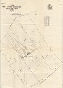
Map - GREAT EXTENDED HUSTLER'S MINE - PLAN OF THE GREAT EXTENDED HUSTLER'S MINE
... Line of Reefs, Bendigo. Bulletin No 33, Plate No X. Lease No 7382. Plan has map of streets. Mine was located in the block bounded by Langston and Anderson Streets and was between the Hustler's Anticline at Surface and the Lightning Hill Anticline at Surface. ...History House 11 Mackenzie Street Bendigo goldfields MINING Parish Map Great Extended Hustler's Mine Hustler's Line of Reefs Mining Lease No 7382 Geological Survey of Victoria Underground Survey Office Bendigo H A Whitelaw Latham & Watson's Shaft Plan of the Great Extended Hustler's Mine on the Hustler's Line of Reefs, Bendigo. Bulletin No 33, Plate No X. Lease No 7382. Plan has map of streets. Mine was located in the block bounded by Langston and Anderson Streets and was between the Hustler's Anticline at Surface and the Lightning Hill ...Plan of the Great Extended Hustler's Mine on the Hustler's Line of Reefs, Bendigo. Bulletin No 33, Plate No X. Lease No 7382. Plan has map of streets. Mine was located in the block bounded by Langston and Anderson Streets and was between the Hustler's Anticline at Surface and the Lightning Hill Anticline at Surface. Latham & Watson's Shaft is also mentioned. Levels are numbered and a table shows the Levels and their Depths. Geological Survey of Victoria. Signed by H A Whitelaw, Underground Survey Office, Bendigo, September 1913. This item has not been scanned or photographed.mining, parish map, great extended hustler's mine, hustler's line of reefs, mining lease no 7382, geological survey of victoria, underground survey office bendigo, h a whitelaw, latham & watson's shaft