Showing 67 items matching " location of shafts"
-
 Bendigo Historical Society Inc.
Document - MINING IN BENDIGO COLLECTION: BENDIGO GOLD FIELDS, 1968
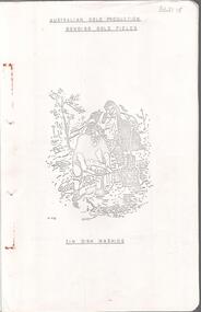
... ... Location of Shafts...Notes include a brief history of gold in Australia, Bendigo Goldfield yields, Bendigo Gold Nuggets, Victorian Nuggets, gold prices, yield for the years 1851 to 1890, lines of reef, mine shafts and depth, location, public buildings and organisations and mines listed for each reef. ...History House 11 Mackenzie Street Bendigo goldfields COTTAGE Miners Mining in Bendigo Bendigo Gold Fields Index V R Dwyer Strzelecki Edward Hargreaves Thomas Hancock Henry Frenchman Wittscheibe Ballerstedt Fortuna Villa George Lansell The Rocks Victoria Nugget Dascombe Nugget Welcome Stranger Welcome Nugget Canadian Nugget Sarah Sands Lady Hotham Maryborough Heron Nugget Blanche Barkley Vicount Canterbury Precious Nugget Poseidon Gold Prices Gold Yield 1851 - 1890 Location of Shafts Mechanics Institute Old Masonic Hall Court St Killians Forrest St Methodist Church Hospital Baptist Church Bendigo Gas Company St Andrews Presbyterian Church Bendigo Benevolent Home Railway St Marys Church of England Bendigo M P Building Society St Pausl Church of England High School City Family Hotel Fire Brigade B U F S Dispensary Synagogue Beehive Store School of Mines Bendigo Miners Association St Marys Convent Dr Backhaus St Mathews Long Gully Salvation Army Post Office Art Gallery Sacred Heart Cathedral Eaglehawk Town Hall Typed copy of the Bendigo Gold Fields , collected and arranged by V. ...Typed copy of the Bendigo Gold Fields , collected and arranged by V. R. Dwyer, 1968. On front cover: Australian Gold Production Bendigo Gold Field. Image of tin dish washing. Cover has an image of two people tin dish washing. Notes include a brief history of gold in Australia, Bendigo Goldfield yields, Bendigo Gold Nuggets, Victorian Nuggets, gold prices, yield for the years 1851 to 1890, lines of reef, mine shafts and depth, location, public buildings and organisations and mines listed for each reef. Typed copy of this document is held in Folder 130, number 3621.18.cottage, miners, mining in bendigo, bendigo gold fields index, v r dwyer, strzelecki, edward hargreaves, thomas hancock, henry frenchman, wittscheibe, ballerstedt, fortuna villa, george lansell, the rocks, victoria nugget, dascombe nugget, welcome stranger, welcome nugget, canadian nugget, sarah sands, lady hotham, maryborough, heron nugget, blanche barkley, vicount canterbury, precious nugget, poseidon, gold prices, gold yield 1851 - 1890, location of shafts, mechanics institute, old masonic hall, court, st killians, forrest st methodist church, hospital, baptist church, bendigo gas company, st andrews presbyterian church, bendigo benevolent home, railway, st marys church of england, bendigo m p building society, st pausl church of england, high school, city family hotel, fire brigade, b u f s dispensary, synagogue, beehive store, school of mines, bendigo miners association, st marys convent, dr backhaus, st mathews long gully, salvation army, post office, art gallery, sacred heart cathedral, eaglehawk town hall -
 Stawell Historical Society Inc
Map, Gold Mines of Australia, Plan of Stawell Goldfield. Mining Leases, 1952
... And Shaft Locations 1952 ...Stawell Historical Society Inc 46 Longfield St Stawell grampians mining gold map G G Birch Mining Surveyor And Shaft Locations 1952 Plan of Stawell Goldfield. ...And Shaft Locations 1952 G G Birch Mining Surveyormining, gold, map -
 Ringwood and District Historical Society
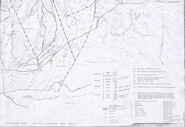
Map - Maps, Geological Map Donvale to Chirnside Park, also Victorian Railways Maps of Hawthorn to Lilydale Line incl Ringwood to East Ringwood - 1881
... Geological map includes location of mine shafts circa 1920....Shaft. Faint photocopies of sections of larger maps. Geological map includes location of mine shafts circa 1920. ...Faint photocopies of sections of larger maps. Geological map includes location of mine shafts circa 1920.Victory Shaft, North Victory Shaft, South Caledonia Shaft, Caledonia Shaft, North Caledonia Shaft, Black Swan Shaft, Reward Shaft, Consols Shaft, Blocks Shaft, Devonshire Shaft, Crown Shaft, Yarra Tunnel Reef Working, Bright's Shaft, Kingwood Antimony Company Shaft (Boardman's Shaft), Southern Shaft. -
Stawell Historical Society Inc
Map, Gold Mines of Australia, Stawell Investment Geological Plan. Mine Area showing Mineshafts
... The Reefs Mine shaft locations...Stawell Historical Society Inc 46 Longfield St Stawell grampians mining gold map Gold Mines of Australia Ltd The Reefs Mine shaft locations Stawell Investment Geological Plan. ...The Reefs Mine shaft locationsGold Mines of Australia Ltd mining, gold, map -
 Bendigo Historical Society Inc.
Plan - Hustlers Reef Reserve, May 1914
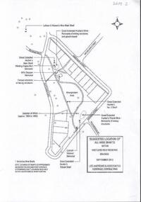
... One page photocopy of plan titled 'Suggested location of all mine shafts within Hustlers Reef Reserve Bendigo September 2023. ...On bottom of page 'note location of shafts is approximate and based on documentary evidence determining exact location requires on-site geotechnical investigation' Plan Hustlers Reef Reserve ...Seven men were killed at the Great Extended Hustler's mine disaster on 2nd May 1914 by an explosion of dynamite occurring as the men were waiting at the plat to ascend the mine at the end of their shift. No blame was attached to anyone in the findings of the inquisition. It was unknown what caused the dynamite to explode. This document formed part of the research done at the time of the 100 years commemoration of the mine disaster, held at Hustlers Hill in 2014. One page photocopy of plan titled 'Suggested location of all mine shafts within Hustlers Reef Reserve Bendigo September 2023. Lee Andrews & Associates Heritage Consulting' Plan shows suggested location of Great Extended Hustlers Tribute Mine, Great Extended Hustlers No. 2 shaft, location of whim, Latham and Watson's mine main shaft, Great Extended Hustlers main shaft and winding engine. On bottom of page 'note location of shafts is approximate and based on documentary evidence determining exact location requires on-site geotechnical investigation'great extended hustlers, goldmining, accidents, coronial inquest, crowhter, blair, campbell, chinn, forster, martin, ryan, thomas, richard reed, 1914 -
Bendigo Historical Society Inc.
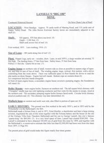
Map - BIG 180 SHAFT POSITION, No date visible
... Map: Plan showing the location of various shafts in the Victoria Hill area, hand draughted in pencil. ...Victoria Hill Big 180 Map: Plan showing the location of various shafts in the Victoria Hill area, hand draughted in pencil. ...Map: Plan showing the location of various shafts in the Victoria Hill area, hand draughted in pencil. Scale 2 Chains to 1 inchmap, bendigo, mining plan, mining , gold mines. victoria hill, big 180 -
Clunes Museum
Map, Surface Geology Plan
... Plans show various shaft locations...Clunes Museum 36 Fraser Street enter building through Collins Place Clunes goldfields Plans show various shaft locations north broken hill ltd surface geology plan .1 C-21 North Broken Hill Ltd Clunes Block 23/19 .2SOUTH CLUNES MINE Ltd Clunes Block 19/19 .1 Photocopy of Plan Block 23/19 Scale 1 inch = 100 feet .2 Photocopy of Plan Block 19/19 Scale 1 inch = 100 feet .3 AERIAL PHOTOGRAPH WITH WORKINGS MARKED - LAMINATED Surface Geology Plan Map MAP ...Plans show various shaft locations.1 Photocopy of Plan Block 23/19 Scale 1 inch = 100 feet .2 Photocopy of Plan Block 19/19 Scale 1 inch = 100 feet .3 AERIAL PHOTOGRAPH WITH WORKINGS MARKED - LAMINATED.1 C-21 North Broken Hill Ltd Clunes Block 23/19 .2SOUTH CLUNES MINE Ltd Clunes Block 19/19north broken hill ltd, surface geology plan -
 Bendigo Historical Society Inc.
Document - MINING REPORTS - LANSELL'S BIG 180
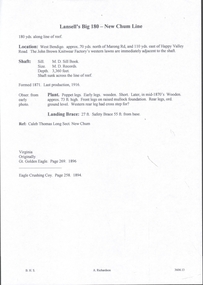
... Notes give detailed location of the shaft, when it was formed and last production in 1916. ...Notes give detailed location of the shaft, when it was formed and last production in 1916. ...Partial page of handwritten notes on Lansell's Big 180 Mine on the New Chum Line. Notes give detailed location of the shaft, when it was formed and last production in 1916. Also some notes on the poppet legs.document, gold, mining reports, lansell's big 180, john brown knitwear factory, caleb thomas -
Bendigo Historical Society Inc.
Map - MINE LOCATION DRAWING AT VICTORIA HILL
... Claims and shafts location for: Rae and co. - Noye and co. - Wittscheibe. ...History House 11 Mackenzie Street Bendigo goldfields MINING Business Claims and shafts location for: Rae and co. - Noye and co. - Wittscheibe. ...Claims and shafts location for: Rae and co. - Noye and co. - Wittscheibe. Some additions to drawing made in pencil.mining, business -
 Bendigo Historical Society Inc.
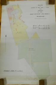
Plan - MARKS COLLECTION: LEASE PLANS GREAT SOUTHERN GOLD MINE BENDIGO
... On bottom '32 feet to one inch' and 'This plan was devised from Government Mining Lease Plans and from actual survey' Signed E.F Brown, certificated mining and authorised surveyor 25/6/87' Leases No. 5429 and 4810 details location of shaft, tramway, battery, engine house and boiler. ...On bottom '32 feet to one inch' and 'This plan was devised from Government Mining Lease Plans and from actual survey' Signed E.F Brown, certificated mining and authorised surveyor 25/6/87' Leases No. 5429 and 4810 details location of shaft, tramway, battery, engine house and boiler. ...Plan on heavy paper, tightly rolled. On top of plan "Plan of Leases 5429, 4810, 4811 and 5429", The Property of the Great Southern Gold Mining Co. Bendigo' \Total area123 acres, 3 roods, 33 perches, excised, nett area 122, 0. 38. On bottom '32 feet to one inch' and 'This plan was devised from Government Mining Lease Plans and from actual survey' Signed E.F Brown, certificated mining and authorised surveyor 25/6/87' Leases No. 5429 and 4810 details location of shaft, tramway, battery, engine house and boiler. Large mining dam outlined.bendigo, mining, great southern gold mine -
Stawell Historical Society Inc
Map, Western Mining Corporation Limited, Shaft Location Plan April 1981, 1981
... Western Mining Corporation Limited, Shaft Location Plan April 1981...Western Mining Corporation Ltd Shaft Location Plan 1981 Very Large Plot Showing Contours and Streets Without names. ...Sheet 1 0f 2 Western Mining Corporation Limited, Shaft Location Plan April 1981 Map ...Western Mining Corporation Ltd Shaft Location Plan 1981 Very Large Plot Showing Contours and Streets Without names. Sheet 1 0f 2 stawell, mining -
Stawell Historical Society Inc
Map, Western Mining Corporation Ltd Shaft Location Plan 1981, 1981
... Western Mining Corporation Ltd Shaft Location Plan 1981 ... Western Mining Corporation Ltd Shaft Location Plan 1981 Very Large Plot Showing Contours and Streets Without names. ...Sheet 2 0f 2 Western Mining Corporation Ltd Shaft Location Plan 1981 Map ...Western Mining Corporation Ltd Shaft Location Plan 1981 Very Large Plot Showing Contours and Streets Without names. Sheet 2 0f 2 stawell, mining -
 Melbourne Tram Museum
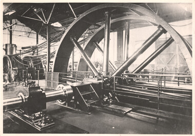
Photograph - Interior of a cable tram Engine House, c1900
... Photograph of the interior of a Melbourne cable tram engine house showing the rope drives and the drive shafts. Location not known, though it could be Brunswick given the location of a doorway. ...Melbourne Tram Museum 8 Wallen Road Hawthorn melbourne Photograph of the interior of a Melbourne cable tram engine house showing the rope drives and the drive shafts. Location not known, though it could be Brunswick given the location of a doorway. ...Photograph of the interior of a Melbourne cable tram engine house showing the rope drives and the drive shafts. Location not known, though it could be Brunswick given the location of a doorway. Also known as winding houses or power houses.Yields information about the interior of an engine house.Black and white print with plain backtramways, engine houses, cable trams, winding houses -
 Bendigo Historical Society Inc.
Document - LANSELL'S BIG 180 MINE - CONDENSED HISTORICAL RECORD OF LANSELL'S BIG 180 MINE
... Notes include location, shaft, first worked, size of lease, plant, engine house, boiler rooms, mullock heap, early history, Prominent, best gold, underground connections, pressurised hot water, diamond drill bores and a table with depths and the increase in temperature with the depth (in Fahr). ...Notes include location, shaft, first worked, size of lease, plant, engine house, boiler rooms, mullock heap, early history, Prominent, best gold, underground connections, pressurised hot water, diamond drill bores and a table with depths and the increase in temperature with the depth (in Fahr). ...Two handwritten and three typed copies of a Condensed Historical Record of Lansell's Big 180 Mine on the New Chum Line of Reef. Notes include location, shaft, first worked, size of lease, plant, engine house, boiler rooms, mullock heap, early history, Prominent, best gold, underground connections, pressurised hot water, diamond drill bores and a table with depths and the increase in temperature with the depth (in Fahr). Albert Richardson Collection. document, gold, lansell's big 180 mine, lansell's big 180 mine, condensed historical record of lansell's big 180 mine, wittscheibe, ballerstadt, ernst mueller, theodore ballerstadt, george lansell, north old chum, victoria quartz, mines dept special edition 'australian mining standard' 1/6/1899, mines dept booklet 'bendigo goldfield' 1936, quarterly reports, lansell's 180 mine 'transverse sections, annals of bendigo mining sections, a richardson's observations from old photographs and measurements of mining plans, measurements taked from caleb thomas' report mines dept 1875, 'report on observation of underground temperature at bendigo' james stirling government geologist 1899, a richardson -
 Bendigo Historical Society Inc.
Document - ALBERT RICHARDSON COLLECTION: SOUTH NEW MOON MINE EAGLEHAWK
... Information includes the location, depth of shaft, steel poppet legs, engine house, air compressor, battery, company ownership, battery. ...Information includes the location, depth of shaft, steel poppet legs, engine house, air compressor, battery, company ownership, battery. ...Two-page typed document with map, detailing information on the South New Moon Gold Mine on the Garden Gully line of reef. Information includes the location, depth of shaft, steel poppet legs, engine house, air compressor, battery, company ownership, battery. The shaft The 'Walker and Coy' winding engine of the later company together with poppet heads was removed later to the South Virginia company between Napier and Market Street, Eaglehawk. Gold production from both companies who owned the mine was 257,498 oz.'.bendigo, mining, south new moon gold mine -
 Bendigo Historical Society Inc.
Document - SOUTH NEW MOON GARDEN GULLY LINE OF REEF
... An historical overview of the mine is provided with information regarding its location, depth of shaft, original company, engine house, air compressor, battery and years of operation. ...An historical overview of the mine is provided with information regarding its location, depth of shaft, original company, engine house, air compressor, battery and years of operation. ...Two page typed carbon copy of document, headed 'South New Moon, Garden Gully line of Reef', located one mile north from Eaglehawk post Office. An historical overview of the mine is provided with information regarding its location, depth of shaft, original company, engine house, air compressor, battery and years of operation. The steel poppet legs were approximately 85 ft high and had a greater slope than usual on the front legs. ' Said to be the best poppet legs on the field'.Albert Richardsonbendigo, mining, south new moon mine -
 Bendigo Historical Society Inc.
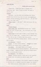
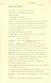
Document - MURCHISON SHAFT
... Victorian Heritage Database Report Report generated 03/03/25 MURCHISON SHAFT Location LESTER STREET SAILORS GULLY, GREATER BENDIGO CITY Municipality GREATER BENDIGO CITY Level of significance Heritage Inventory Site Heritage Inventory (HI) Number H7724-0192 Heritage Listing Victorian Heritage Inventory Other Names NEW CHUM REEF, Hermes Number 8493...History House 11 Mackenzie Street Bendigo goldfields Victorian Heritage Database Report Report generated 03/03/25 MURCHISON SHAFT Location LESTER STREET SAILORS GULLY, GREATER BENDIGO CITY Municipality GREATER BENDIGO CITY Level of significance Heritage Inventory Site Heritage Inventory (HI) Number H7724-0192 Heritage Listing Victorian Heritage Inventory Other Names NEW CHUM REEF, Hermes Number 8493 DOCUMENT Gold murchison shaft Virginia Handwritten notes with typed copy, on the Murchison Shaft on the New Chum Line. 1870 - 1871. 6,7 tons - 651 ozs. ...Victorian Heritage Database Report Report generated 03/03/25 MURCHISON SHAFT Location LESTER STREET SAILORS GULLY, GREATER BENDIGO CITY Municipality GREATER BENDIGO CITY Level of significance Heritage Inventory Site Heritage Inventory (HI) Number H7724-0192 Heritage Listing Victorian Heritage Inventory Other Names NEW CHUM REEF, Hermes Number 8493Handwritten notes with typed copy, on the Murchison Shaft on the New Chum Line. 1870 - 1871. 6,7 tons - 651 ozs. Bottom Level - 2315 ft. Virginia worked this shaft 1883 to -. Lease had a length of 1400 ft. on New Chum Line.document, gold, murchison shaft, virginia -
 Bendigo Historical Society Inc.
Document - HERCULES AND ENERGETIC MINES - NOTES ON THE HERCULES AND ENERGETIC MINES
... Notes include Location, depth of shafts, plant and machinery, Early History and Prominence. ...Notes include Location, depth of shafts, plant and machinery, Early History and Prominence. ...Four typed copies of notes on the Hercules and Energetic Mines. Notes include Location, depth of shafts, plant and machinery, Early History and Prominence. Reference: Mines Dept Special Edition Australian Mining Standard 1.6.1899, Mines Dept Booklet Bendigo Goldfield 1936, Mines Dept Annual and Quarterly Reports, Annals of Bendigo Mining Sections 1876 - 1921, A Richardson, The Bendigo Goldfield Registry J N Macartney 1.3.1871, Mines Dept Bulletin No 30 h Herman 1914, Bendigo Amalgamated Goldfields Coy Financial Reports 1920. There are three typed copies, also the original handwritten notes.mine, gold, hercules and energetic mines, notes on the hercules and energetic mines, the north energetic, the victoria pilot, plan of leases of 1870, bendigo amalgamated goldfields company, sheepshead line, central blue, big blue, mines dept special edition australian mining standard 1.6.1899, mines dept booklet bendigo goldfield 1936, annals of bendigo mining sections 1876 - 1921, a richardson -
 Bendigo Historical Society Inc.
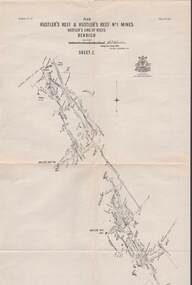
Map - STRUGNELL COLLECTION: HUSTLER'S LINE OF REEFS, September 1913
... Drawing shows a plan view of reefs and shaft locations ....Drawing shows a plan view of reefs and shaft locations . Map STRUGNELL COLLECTION: HUSTLER'S LINE OF REEFS ...Map, Hustler's Line of Reefs, Hustler's Reef & Hustler's Reef No.1 Mines Plan.Plate No. XV1.(16) Sheet 2 .Bulletin No 33 Signed H.A.Whitelaw.Underground Survey Office, Bendigo, September,1913. Included is the emblem of the Geological Survey of Victoria. Drawing shows a plan view of reefs and shaft locations .Underground Survey Office, Bendigomap, bendigo, hustler's reef & hustler's reef 1 -
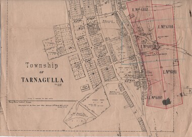 Tarnagulla History Archive
Linen-Backed Map of Tarnagulla Dated 1860 with Updates, Including Mining Leases
... The map clarifies details of the mining leases as they stood in 1924, and the map also identifies previously uncertain details such as the location of the battery well, and also the location of the 1909 syndicate to the south of the Sandy Creek Co's shaft. The lightly pencilled location of the Birthday shaft is incorrect. ...The map clarifies details of the mining leases as they stood in 1924, and the map also identifies previously uncertain details such as the location of the battery well, and also the location of the 1909 syndicate to the south of the Sandy Creek Co's shaft. The lightly pencilled location of the Birthday shaft is incorrect. ...This is a very nice linen-backed map first published in 1860 and progressively updated, the latest being 1924 at the time of Government boring on the Poverty Reef. The map clarifies details of the mining leases as they stood in 1924, and the map also identifies previously uncertain details such as the location of the battery well, and also the location of the 1909 syndicate to the south of the Sandy Creek Co's shaft. The lightly pencilled location of the Birthday shaft is incorrect. This mine was located further to the east. -
 Bendigo Historical Society Inc.
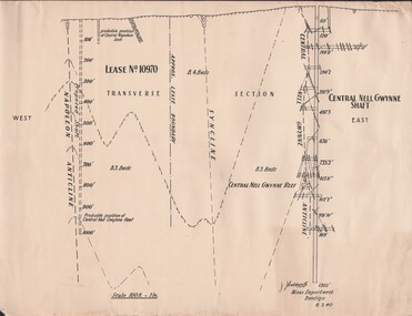
Document - MCCOLL, RANKIN AND STANISTREET COLLECTION: NAPOLEON REEF GOLD MINING CO. N.L, 1940
... Document: 4 copies of plan of Transverse Section of Napoleon Anticline Lease no 10970, plan shows proposed shaft location and depth (1000 ft), for Napoleon Reef Gold Mining Co, also location and depth of adjacent Central Nell Gwynne Shaft scale 100ft = 1 inch, Prepared by J.J. ...History House 11 Mackenzie Street Bendigo goldfields ORGANIZATION Business industrial - mining McColl Rankin & Stanistreet mining gold mining Napoleon Reef Document: 4 copies of plan of Transverse Section of Napoleon Anticline Lease no 10970, plan shows proposed shaft location and depth (1000 ft), for Napoleon Reef Gold Mining Co, also location and depth of adjacent Central Nell Gwynne Shaft scale 100ft = 1 inch, Prepared by J.J. ...Document: 4 copies of plan of Transverse Section of Napoleon Anticline Lease no 10970, plan shows proposed shaft location and depth (1000 ft), for Napoleon Reef Gold Mining Co, also location and depth of adjacent Central Nell Gwynne Shaft scale 100ft = 1 inch, Prepared by J.J. Caldwell Mines Dept Bendigo.organization, business, industrial - mining, mccoll rankin & stanistreet, mining, gold mining, napoleon reef -
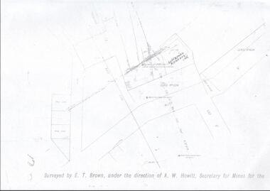 Bendigo Historical Society Inc.
Map - LANSELL'S BIG 180 MINE - LOCALITY OF LANSELL'S NO 180 SHAFT
... Buff coloured photocopy of the location of Lansell's No 180 Shaft and showing the positions of Underground Workings near the intersection of Lily St and Alley St. ...History House 11 Mackenzie Street Bendigo goldfields MAP Bendigo mining plan Lansell's Big 180 Mine Locality of Lansell's No 180 Shaft North Old Chum Co Shaft New Chum and Victoria Co Shaft Luffman Brothers E T Brown A W Howitt Buff coloured photocopy of the location of Lansell's No 180 Shaft and showing the positions of Underground Workings near the intersection of Lily St and Alley St. ...Buff coloured photocopy of the location of Lansell's No 180 Shaft and showing the positions of Underground Workings near the intersection of Lily St and Alley St. Also mentioned are the North Old Chum Shaft and the New Chum and Victoria Co Shaft. Luffman Brothers has been written in in pen and initialled A R. Printed at the bottom is: Surveyed by E. T. Brown, under the direction of A. W. Howitt, Secretary for Mines for the - (the rest is cut off).map, bendigo, mining plan, lansell's big 180 mine, locality of lansell's no 180 shaft, north old chum co shaft, new chum and victoria co shaft, luffman brothers, e t brown, a w howitt -
 Bendigo Historical Society Inc.
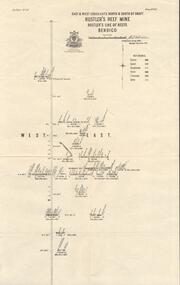
Map - HUSTLER'S REEF MINE - EAST & WEST CROSS-CUTS, NORTH & SOUTH OF SHAFT
... Map shows main shaft and smaller drawing of section with different stone encountered. Also gives location in relation to the shaft, e. g. 225'E & 150'S of Shaft. ...Map shows main shaft and smaller drawing of section with different stone encountered. Also gives location in relation to the shaft, e. g. 225'E & 150'S of Shaft. ...East & West Crosscuts, North & South of Shaft, Hustler's Reef Mine Bulletin No 33, Plate No XIX. Map shows main shaft and smaller drawing of section with different stone encountered. Also gives location in relation to the shaft, e. g. 225'E & 150'S of Shaft. Reference diagram to show the different stone and features encountered. Geological Survey of Victoria emblem. Signed by H A Whitelaw, Underground Survey Office Bendigo, September 1913. mining, parish map, hustler's reef mine, east & west cross-cuts north & south of shaft, geological survey of victoria, h a whitelaw, underground survey office bendigo -
 Bendigo Historical Society Inc.
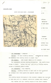
Document - NEW CHUM LINE OF REEF MUNGO GROUP EAGLEHAWK
... Small map on second page shows the location of the Sadowa shaft, St. Mungo shaft and the Lady Barkly shaft. ...Small map on second page shows the location of the Sadowa shaft, St. Mungo shaft and the Lady Barkly shaft. ...Two page document detailing the Mungo Group of Mines along the New Chum line of reef, Eaglehawk. The mines described are: Ellenborough, 2100 feet deep St Mungo, 2,600 feet deep The Lady Barkly, 1,350 feet deep, close to Upper Road with a 40 head battery on the other side. South St Mungo, known as the Governor Barkly in the earlier days. Small map on second page shows the location of the Sadowa shaft, St. Mungo shaft and the Lady Barkly shaft. Victoria Street and Upper Road marked on the map. 'Between Caldwells Road and Victoria Street and Upper Road intersection, nine mines and three crushing batteries worked at one period. All on the New Chum line of reef.' Not signed but most probably written by Albert Richardson.bendigo, mining, mungo group of mines, eaglehawk -
 Tennis Australia
Racquet, Circa 1905
... Remains of butt cap printed with racquet care instructions, and manufacturer's name and location. On right side of shaft, manufacturer name and country of manufacture are printed. ...Remains of butt cap printed with racquet care instructions, and manufacturer's name and location. On right side of shaft, manufacturer name and country of manufacture are printed. ...A Wright & Ditson 'Pim' model tennis racquet with composite convex throat. Rounded flat top head with cloth tape reinforcements around shoulders. Model name printed across throat on obverse. Manufacturer's trademark/logo features across throat on reverse. Fine-grooved octagonal handle, trace remains of leather end wra. Remains of butt cap printed with racquet care instructions, and manufacturer's name and location. On right side of shaft, manufacturer name and country of manufacture are printed. Red buffers lodged under string loops on sides of throat. Materials: Wood, Metal, Lacquer, Glue, Ink, Leather, Nylon, Cloth tapetennis -
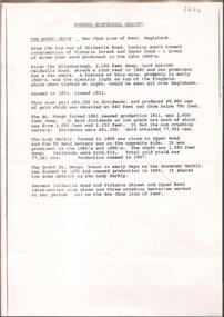
 Bendigo Historical Society Inc.
Document - LONG GULLY HISTORY GROUP COLLECTION: GUIDE TO SOME FAMOUS MINES
... Mentioned is the mine's location, depth of shaft, poppet legs, machinery, location of engine house, gold yield, dividends and owners of mine. ...Mentioned is the mine's location, depth of shaft, poppet legs, machinery, location of engine house, gold yield, dividends and owners of mine. ...Three pages titled Guide to Some Famous Mines. Compiled by A Richardson. Each mine is listed as on the reef it is situated on. Reefs are The New Chum Line of Reef and the Garden Gully Line of Reefs, and the Devonshire Group. Mentioned is the mine's location, depth of shaft, poppet legs, machinery, location of engine house, gold yield, dividends and owners of mine. The mines are: The New Chum Line of Reef. The New Chum Railway, Kochs Pioneer, Windmill Hill, Confidence Extended, Johnson's No 1, Johnson's No2, Johnson's No 3, North Johnson's, Princess Dagmar, Golden Age, Johnson's Reef Extended, Golden Pyke, Constellation, Great Northern, Virginia, Specimen Hill United, New Argus, Clarence United, North Argus, South New Moon, New Chum Hill, The New Chum and Victoria, Catherine Reef United. Garden Gully Line of Reefs. The Great Southern, Ulster United, Londonderry, South Garden, The Sea Amalgamated, Garden Gully United, Victory and Pandora, Unity Mine, Carlisle United, Cornish United, Eureka Extended, South Belle Vue United, Shenandoah, Shamrock, New Chum Consolidated, New Chum United, Lansell's 222, Rae's Open Cut, Great Central Victoria, Victoria Consols, The Ironbark, Hercules and Energetic, Pearl, The Devonshire Group. North of Staley,The Duke of Edinburgh, New St Mungo, Duchess Tribute, South Devonshire, Duchess of Edinburgh, Princess Alexandra, West United Devonshire, Hopewell, Phoenix. Yhe Mungo Mines. Unicorn, South St Mungo, Lady Barkly, The St Mungo, Sadowa, Eastwood. Snobs Hill Group. The Ellenborough, The Belmont and Saxby, York and Durham, The Acadia, William's United, The Victoria Hill - Ironbark, The North Old Chum, Lansell's Big 180, Ballerstadt's Open-Cut and The Victoria Quartz.bendigo, history, long gully history group, the long gully history group - guide to some famous mines, a richardson, the new chum railway, kochs pioneer, windmill hill, confidence extended, johnson's no 1, johnson's no2, johnson's no 3, north johnson's, princess dagmar, golden age, johnson's reef extended, golden pyke, constellation, great northern, virginia, specimen hill united, new argus, clarence united, north argus, south new moon, new chum hill, the new chum and victoria, catherine reef united, the great southern, ulster united, londonderry, south garden, the sea amalgamated, garden gully united, victory and pandora, unity mine, carlisle united, cornish united, eureka extended, south belle vue united, shenandoah, shamrock, new chum consolidated, new chum united, lansell's 222, rae's open cut, great central victoria, victoria consols, the ironbark, hercules and energetic, pearl, the duke of edinburgh, new st mungo, duchess tribute, south devonshire, duchess of edinburgh, princess alexandra, west united devonshire, hopewell, phoenix, unicorn, south st mungo, lady barkly, the st mungo, sadowa, eastwood, the ellenborough, the belmont and saxby, york and durham, the acadia, william's united, the victoria hill - ironbark, the north old chum, lansell's big 180, ballerstadt's open-cut, the victoria quartz -
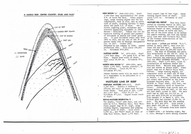 Bendigo Historical Society Inc.
Document - LONG GULLY HISTORY GROUP COLLECTION: HUSTLERS LINE OF REEF
... Depth of shaft, machinery, location, dividends and yields are also mentioned. ...Depth of shaft, machinery, location, dividends and yields are also mentioned. ...Page mentioning mines on the Hustlers Line of Reef. The are: Fortuna Hustlers, Royal Hustlers Reserve No 2 - City and Park Shafts, Great Hustlers, Latham, Watson, Great Extended Hustlers, Tribute or Pups Shaft, Bendigo's Worst Mining Disaster May 2 1914, Hustlers Reef (Old Hustlers) and Hustlers Reef No 1, Lansell's Comet Lightening Hill Line, The Old Comet (Cooper's Claim), United Hustlers and Redan, K K Shaft, North or New Hustlers (once known as Agnew Hustlers), Derby Line - Johnson's No 3, Paddy's Gully Line, Lansell's 'Sandhurst' (Needle), Needle Loops, Cleopatra Needle top, British American, Collman and Tacchi and South Virginia. Also mentioned is Total Gold Yield, Main Shafts on Field, Price of Gold (Old Currency) and Saddle Reefs and Spurs. Also mentioned are New Moon, Suffolk United, South New Moon and North New Moon. There is a diagram of a Saddle Reef, Centre Country, Spurs and Fault. Depth of shaft, machinery, location, dividends and yields are also mentioned. Price of Gold (Old Currency): 1851-1930, Price varied from Approx. £3/17/6 to £4 per ounce. 1938, from £6/19/10 to £7/8/10 per ounce. 1946/47/48 £10/15/3 per ounce, May 1, 1954 £15/12/6 per ounce.bendigo, history, long gully history group, the long gully history group - hustlers line of reef, fortuna hustlers, buckell & jeffrey's, railway goods sheds, rsl memorial hall, camp hill school, royal hustlers reserve no 2 - city and park shafts, jonathan harris, latham and watson, great hustlers, great extended hustlers, wattle gully mine, messrs j hustler latham and watson, tribute or pups shaft, bendigo's worst mining disaster, hustlers reef (old hustlers) and hustlers reef no 1, lansell's comet, the old comet (cooper's claim, united hustlers and redan, k k shaft, north or new hustlers (once known as agnew hustlers), derby line - johnson's no 3, pa ddy's gully line, lansell's 'sandhurst' (needle), needle loops, cleopatra needle top, british american, collman and tacchi, south virginia, saddle reefs and spurs, new moon, suffolk united, south new moon, north new moon -
 The Beechworth Burke Museum
Photograph
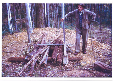
... location the photograph was taken are also unknown. Perhaps in the Beechworth or Stanley area. The photo is associated to another record, 6856 as it has the same elderly gentlemen in the image. He is able to be identified through wearing the same clothes and distinctive hat in both photographs. The photograph is associated to mining as the gentleman is standing next to a small mine site where perhaps a windless or whip was mounted over the entrance of the shaft...location the photograph was taken are also unknown. Perhaps in the Beechworth or Stanley area. The photo is associated to another record, 6856 as it has the same elderly gentlemen in the image. He is able to be identified through wearing the same clothes and distinctive hat in both photographs. The photograph is associated to mining as the gentleman is standing next to a small mine site where perhaps a windless or whip was mounted over the entrance of the shaft ...The date this photograph was taken is unknown. Estimated date 1960-70s. The gentleman in the photograph and location the photograph was taken are also unknown. Perhaps in the Beechworth or Stanley area. The photo is associated to another record, 6856 as it has the same elderly gentlemen in the image. He is able to be identified through wearing the same clothes and distinctive hat in both photographs. The photograph is associated to mining as the gentleman is standing next to a small mine site where perhaps a windless or whip was mounted over the entrance of the shaft. The windless was a structure mounted over the shaft, fitted with a hand-cranked winch, which was usually constructed from wood that would have been found in the surrounding area. Colour rectangular photograph printed on glossy photographic paper.Obverse: Reverse: 6856/ mining, windlass, whip, empty record -
 The Beechworth Burke Museum
Postcard, George Symons, c.1990
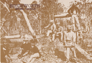
... shaft in the Beechworth region. The photograph has been dated to approximately 1872. This period in history post-dates the Victorian gold rushes which occurred 1852-1853 in Ballarat, Bendigo and Beechworth. During this period, in the 1870s, the surface alluvial gold had been discovered and removed from location...shaft in the Beechworth region. The photograph has been dated to approximately 1872. This period in history post-dates the Victorian gold rushes which occurred 1852-1853 in Ballarat, Bendigo and Beechworth. During this period, in the 1870s, the surface alluvial gold had been discovered and removed from location ...The photograph printed on this postcard comes from the collection of the Mitchell Library in Sydney. It is sepia in tone and depicts seven men standing and sitting around a mine shaft in the Beechworth region. The photograph has been dated to approximately 1872. This period in history post-dates the Victorian gold rushes which occurred 1852-1853 in Ballarat, Bendigo and Beechworth. During this period, in the 1870s, the surface alluvial gold had been discovered and removed from location. Therefore, in order to reach the deeper and less accessible alluvial gold, diggers began to dig shafts into the earth. These shafts sunk below the ground level by 20 to 30 feet and required timber structures around the entrance and winches to bring the paydirt to the top. The top of this wooden structure is visible behind the man standing in the upper right of the image. This type of mining was highly dangerous as mines often caved in which injured the minors and often resulted in death. Thus, following this period, in the early 1900s, miners opted instead for hydrolic slucing which cut away the earth without the devastating consequences of a mine cave in. This particular group of miners appear to have been unable to afford a horse (then worth around 50 pounds) which were generally used at mines like this to help pull buckets attached to ropes up and down the mine. Instead, this group brought the buckets up and down by windlass. The windlass was a wooden structure mounted over the mining shaft and fitted with a hand-cranked winch which enabled the bucket attached to the rope to be brought up and down.Gold was first discovered in Beechworth in Spring and Reid's Creek in the summer of 1852-1853. At its popularity, this region had approximately 8000 people on the gold fields searching for gold on the banks of these creeks. These periods did not require the use of heavy machinery or the digging of deep mining shafts like the one depicted in this image. Therefore, this image has important connotations for the technologies associated with mining during the approximated 1870s when gold was harder to access. This is a later period in gold history which does not fit into the "gold rush" period. Instead, it occurred after the surface gold had disappeared and therefore, is essential for researchers who are investigating the mining techniques and structures used to reach the alluvial gold which was located deeper under ground in the 1870s. This period predates the use of big heavy machinery used to mine in the 1900s which include dredges. Images such as this one can also impart essential information as to the wardrobe and fashion of men during this period. It also imparts knowledge about the landscape of Beechworth which is useful for people researching the environment and impact of gold mining in the north-east region of Victoria. In addition, since this image is a postcard reproduction of an early Australian image which may date to approximately 1990 it can impart knowledge as to the interests of people during this time period when there may have been an increase into Australian history.A sepia tone facsimile of an early Australian photograph (circa 1872) printed as a postcard.Obverse: BEECHWORTH / Victoria, Australia / Reverse: GM 2 3275 / CORRESPONDENCE / AUSTRALIAN / YESTERYEAR / CARDS / ADDRESS / Published by George Symons (057) 65 3240 / THE MINEHEAD C. 1872 / The easily gleaned gold of the early fields did / not last very long. In order to reach less / accessible alluvial gold diggers began sinking shafts as much as twenty to thirty feet down / and the mines required timbering and winches / to bring the paydirt to the top. / This syndicate has been unable to afford the / luxury of a horse (about 50 pounds) and so everything / must go up and down by windlass and rawhide / bucket. / Photo: Mitchell Library, Sydney / A sepia tone facsimile of / an early Australian photographmining album, gold mine, beechworth, burke museum, mine shaft, postcard, australian yesteryear cards, george symons, the minehead, gold fields, alluvial gold, early australia, c.1872, 1872, gold diggers, north east victoria -
 The Beechworth Burke Museum
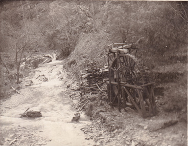
Postcard, 1920
... location for historical study on gold mining during the 1900s. It can provide important information on the types of tools utilised and the impact of the mining on the environment. beechworth mining gold mining quartz mining wallaby reef mine mine battery head 8169 Be / Also near Wallaby Reef Workings / Relics of Rechabite Reef (locality) workings. / Shaft in bed of creek. ...This postcard depicts the set-up of an abandoned gold mine. This includes a water wheel and other mining implements next to a creek. The postcard inscription indicates that this image is of the remains of the Wallaby Reef battery and water wheel. Wallaby Reef was discovered in 1864, and a prospecting claim established a four head battery and water wheel. Quartz was mined there, with gold also discovered at this location at a later date. By 1878 the mine was no longer resulting in rich deposits, this resulted in the miners moving their search for gold closer to the river where they were able to access more gold. This was in approximately 1879. In 1882 a rich deposit was found. In 1908 the battery was closed, and the mine finished. This photo was taken in 1920 and shows the deterioration of the site since its closure. Gold mining was crucial to the development of the Beechworth area. It has strong research and historical value because the clarity of the photo shows all the minute details of the mining equipment. The text on the back also indicates the mine is the Wallaby Mine, which was used for 45 years to find gold and quartz. Therefore, due to the location being quickly abandoned, this site is a rich location for historical study on gold mining during the 1900s. It can provide important information on the types of tools utilised and the impact of the mining on the environment.Black and white postcard photograph on card.8169 Be / Also near Wallaby Reef Workings / Relics of Rechabite Reef (locality) workings. / Shaft in bed of creek. Wheel used to drive sheadd (?) / stamp battery too I believe near B'worth 1920?beechworth, mining, gold mining, quartz mining, wallaby reef mine, mine battery head