Showing 12970 items matching " map"
-
 Greensborough Historical Society
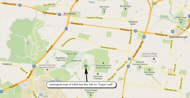
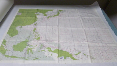
Map, Overlay/comparison Map for 1868 Greensborough-Bundoora Geological Map area, 1868_
... Map...Overlay/comparison Map for 1868 Greensborough-Bundoora Geological Map area....This map is a comparison to the map at Item 2518, questioning the location of "Sugar Loaf". ...Map copied from Google maps....Annotation on map....Annotation by GHS member Ian Bryant. sugarloaf hill bundoora greensborough - maps Annotation on map. Map copied from Google maps. ...This map is a comparison to the map at Item 2518, questioning the location of "Sugar Loaf". Annotation by GHS member Ian Bryant.Map copied from Google maps.Annotation on map.sugarloaf hill, bundoora, greensborough - maps -
 Vision Australia
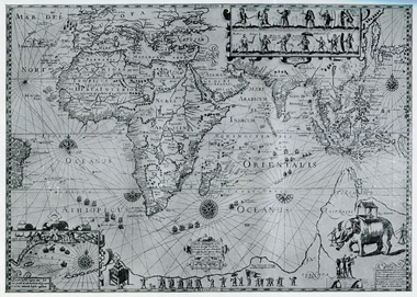
Map - Object, Map of Australia, Polynesia, Melanesia and Malaysia, 1939
... Map of Australia, Polynesia, Melanesia and Malaysia...Map...Tactile map of Australian states and territories, as well as various countries and islands in the South Pacific region, including Papua New Guinea, Indonesia and the Malay peninsula. ...1 paper map with tactile metal markers in red and brown frames...Queensland Braille Map & Model Club...Tunley 1 paper map with tactile metal markers in red and brown frames Map of Australia, Polynesia, Melanesia and Malaysia Map Object Queensland Braille Map & Model Club ...Tactile map of Australian states and territories, as well as various countries and islands in the South Pacific region, including Papua New Guinea, Indonesia and the Malay peninsula. 1 paper map with tactile metal markers in red and brown framesqueensland braille map and model club, r.f. tunley -
 Lara RSL Sub Branch
Map, Framed Map of the western front 1914-1918, Map made by G.F.Trudgion R.A.E. circa 1916
... Map...Framed Map of the western front 1914-1918...map...Map...Map showing position of western front line in 1914 at the start of WW1...Map of the western front 1914-1918...Map made by G.F.Trudgion R.A.E. circa 1916...Lara RSL Sub Branch McClelland Ave Lara Map showing position of western front line in 1914 at the start of WW1 Map is from circa 1916 showing battle area of the Western Front during WW1 map g.f.trudgion r.a.e. western front ww1 world war one north west europe 1914 1916 ww1 casulaties North West Europe Shewing the Western Front 1914-1918 War. ...Map showing position of western front line in 1914 at the start of WW1Map is from circa 1916 showing battle area of the Western Front during WW1Map of the western front 1914-1918North West Europe Shewing the Western Front 1914-1918 War. Below is description of Australian ANZAC's on Western Front and a graph on Comparison of Casualties from Major Western Front Battlesmap, g.f.trudgion, r.a.e., western front, ww1, world war one, north west europe, 1914, 1916, ww1 casulaties -
 National Vietnam Veterans Museum (NVVM)
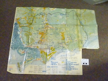
Map, Long Tan Original Battle Map
... Map...Long Tan Original Battle Map.......Map...Map...Original topographical map of Long Tan area showing operational marking in black pen. ...This map is the original map from 1 ATF HQ on the day of the Battle of Long Tan, 18th August, 1966....National Vietnam Veterans Museum (NVVM) 25 Veterans Drive Newhaven phillip-island-and-the-bass-coast Battle of Long Tan Map This map is the original map from 1 ATF HQ on the day of the Battle of Long Tan, 18th August, 1966. ...Original topographical map of Long Tan area showing operational marking in black pen. Areas 1-4 marked 5RAR section.This map is the original map from 1 ATF HQ on the day of the Battle of Long Tan, 18th August, 1966.battle of long tan, map -
 Kew Historical Society Inc
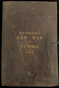
Map, Whitehead's Map of Victoria, With Alphabetical Key, 1869, 1869
... Map...Whitehead's Map of Victoria, With Alphabetical Key, 1869...Map...When E. Whitehead's New Map of Victoria was released in 1869, an advertisement in the Bendigo Advertiser (16 July 1869) noted that: "This beautifully engraved Map has been revised and brought down to the present time; and, with the Alphabetical Key, is the most complete and the cheapest Map ever published; Price, 6d plain; 1s colored; 2s 6d in case; on linen, post free, 2d extra. ...Map of Victoria with gold mining areas, notes on topography, transport routes. ...Cover "WHITEHEAD'S NEW MAP OF VICTORIA 1869"...Whitehead's Map of Victoria, With Alphabetical Key, 1869 Map Map E Whitehead & Co. ...When E. Whitehead's New Map of Victoria was released in 1869, an advertisement in the Bendigo Advertiser (16 July 1869) noted that: "This beautifully engraved Map has been revised and brought down to the present time; and, with the Alphabetical Key, is the most complete and the cheapest Map ever published; Price, 6d plain; 1s colored; 2s 6d in case; on linen, post free, 2d extra. E.. WHITEHEAD and CO, Publishers, 67 Collins-street east." The following year, 1870, Whitehead's promoted the edition in the Portland Guardian and Normanby General Advertiser (3 January 1870), advising that: "WHITEHEAD'S NEW MAP OF VICTORIA, 1869 ... is corrected to the latest date, and around is arranged an Alphabetical Key, with Post Towns and Money Order Olffices marked. The Map being divided into squares and numbered, by reference to the Key any place can be found immediately. Price Is beautifully colored, or mounted on linen in case, 2s 6d. Post free, 2d extra, in Victoria. B. Whitehead and C0., Puolishers, 67 Collins-street East, Melbourne". In the same edition of the Portland Advertiser, they also promoted their business generally, saying: "E WHITEHEAD and Co., Stationers, Engravers, Lithographers, 67 Collins street East, execute every description of Lithographic PRINTING, BILL-HEADS. NOTE Headings. Business Dies Engraved and Embossed on Envelopes &c. ARMS, MONOGRAMS, AND CRESTS Engraved and Embossed in Colour, superior to any other house in the Colony. Specimens, post free, 2d. Lithographers, &c, to H.R.H. the Duke of Edinburgh, and Die-inkers and Embossers to His Excellency Sir J. H. T. Manners-Sutton, K C.B. Orders executed for the Trade". Whitehead’s New Map of Victoria 1869 is is an important record of region created towards the end of the Victorian Gold Rush (1851-1869). In addition to its historical significance, this is a rare map, of which the only known copies in Australian public collections are those held at the National Library of Australia, the State Library of Victoria, State Library of New South Wales and the University of Queensland Library.Map of Victoria with gold mining areas, notes on topography, transport routes. Relief shown by hachures. List of towns with distance from Melbourne in map margin. [Melbourne] : Printed & Published by ... E Whitehead & Co ... 67 Collins Street East, 1869 1 map : col., mounted on linen ; 38.4 x 55.4 cm, folded to 18 x 12 cm.Cover "WHITEHEAD'S NEW MAP OF VICTORIA 1869"maps - victoria - 1860s, e whitehead's new map of victoria 1869, whitehead's map of victoria with alphabetical key 1869, cartography, gold rush -
 Vision Australia
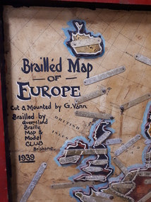
Map - Object, Brailled Map of Europe, 1939
... Brailled Map of Europe...Map...This tactile map of Europe was created in 1939, and brailled by the Queensland Braille Map and Model Club. ...Queensland Braille Map & Model Club...Vision Australia 454 Glenferrie Road Kooyong melbourne This tactile map of Europe was created in 1939, and brailled by the Queensland Braille Map and Model Club. ...This tactile map of Europe was created in 1939, and brailled by the Queensland Braille Map and Model Club. Cut and mounted by G. Vann with geographical inforamtion provided by Miss E Southern. The Queensland Braille Map and Model Club was a volunteer organisation which produced tactile maps from the 1920s to the late 1940s. These were sent as presents to schools, organisations and missions for people who were blind or vision impaired around Australia, New Zealand, Syria, India, Canada, Papua New Guinea and Africa. Due to free postage of Braille obtained by Tilly Aston and her compatriots, the maps were transported gratis within Australia and at a cheap rate overseas. When this map was made, East Prussia, Danzig and the Levant States were all separate countries. Some information about each country (name, area in sq miles and population) is written on a small door on the right hand side, which can be opened to reveal the same information in Braille. At the base is a braille and handwritten note "Information about maps gratis from Miss E Southern "Kingsley" George St, Brisbane. "For lending to the Blind" is written at the base of the wooden frame.1 paper attached to wooden mount with metal labels, on the right hand side a small door with country information on the front and opens to reveal the same in Braille. queensland braille map and model club, r.f. tunley -
 Lara RSL Sub Branch
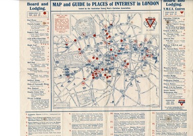
Map, Map of London
... Map...Map of London...Map of London including Places of interest and Accommodation for Australian Navy, and Australian Imperial Force...Map of London - YMCA - Place of Interest and Accommodation for Soldiers and Sailors in London 1917...Map of London Rising Sun Badge Places of interest Accommodation for sailors and soldiers in London...Lara RSL Sub Branch McClelland Ave Lara Map of London including Places of interest and Accommodation for Australian Navy, and Australian Imperial Force Map given to Australian Navy and Imperial forces in London during WW1 map london ymca ww1 Map of London Rising Sun Badge Places of interest Accommodation for sailors and soldiers in London Map of London - YMCA - Place of Interest and Accommodation for Soldiers and Sailors in London 1917 Map of London Map ...Map of London including Places of interest and Accommodation for Australian Navy, and Australian Imperial ForceMap given to Australian Navy and Imperial forces in London during WW1Map of London - YMCA - Place of Interest and Accommodation for Soldiers and Sailors in London 1917Map of London Rising Sun Badge Places of interest Accommodation for sailors and soldiers in Londonmap london ymca ww1 -
 Bendigo Military Museum
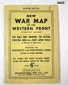
Map - WAR MAP WESTERN FRONT, Geographer's Map Co Ltd, c.WWII
... Map...Map...Folded map fixed into yellow cardboard folder with black printing. ...On cover in black print: “Second Edition. New War Map of the Western Front”...Geographer's Map Co Ltd...Map WAR MAP WESTERN FRONT. Geographer's Map Co Ltd ...Folded map fixed into yellow cardboard folder with black printing. Map covers battle areas late in WWII of Maginot Line & Siegfried Line from Metz, France to Karlsruhe, Germany.On cover in black print: “Second Edition. New War Map of the Western Front”map, seigfreid, maginot -
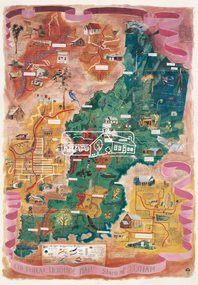 Eltham District Historical Society Inc
Map (item), Megan Evans, Cultural Heritage Map, Shire of Eltham, 1993
... Map...Cultural Heritage Map, Shire of Eltham......Map...Map..."Evans remembers being surprised they had asked an artist to create this map rather than a designer. Originally made as a watercolour, the map was later made into posters and adorned many homes around the area. ...Paper map folded into three half-folds (8 panels) colour printed single side...Nillumbik Arts News December 2023. artist Buildings Cultural Heritage Map Fauna Flora Map Megan Evans shire of eltham Wurundjeri Paper map folded into three half-folds (8 panels) colour printed single side Cultural Heritage Map, Shire of Eltham Map Map Megan Evans Shire of Eltham ...Copy of artist's map of the Shire of Eltham with numerous historical and cultural places of interest illustrated and notated including evidence of original Wurundjeri occupation and local flora and fauna. The original watercolour is held in the Nillumbik Shire Council Civic Collection. "Evans remembers being surprised they had asked an artist to create this map rather than a designer. Originally made as a watercolour, the map was later made into posters and adorned many homes around the area. The map creatively interprets the town and provides a wayfinding to both cultural and historical points in the area." Nillumbik Arts News December 2023. artist, buildings, cultural heritage map, fauna, flora, map, megan evans, shire of eltham, wurundjeri -
 Ballarat Heritage Services
Map, Map Published at Paris, 1587, 1527
... Map...Map Published at Paris, 1587...map...This map shows a portion of New Guinea, but the plae occupied by Austrlai was left as open ocean....Copy of a map from 'A Short HIstory of Australia' by Ernest Scott....Ballarat Heritage Services PO Box 2209 Bakery Hill Post Office goldfields This map shows a portion of New Guinea, but the plae occupied by Austrlai was left as open ocean. map paris map new guinea early australian mapping Copy of a map from 'A Short HIstory of Australia' by Ernest Scott. ...This map shows a portion of New Guinea, but the plae occupied by Austrlai was left as open ocean.Copy of a map from 'A Short HIstory of Australia' by Ernest Scott.map, paris map, new guinea, early australian mapping -
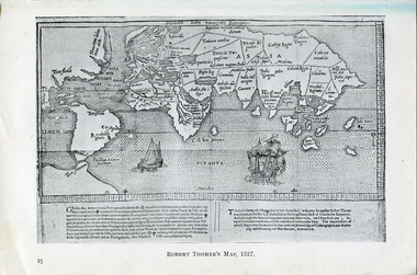 Ballarat Heritage Services
Photograph - Map, Robert Thorne's Map, 1527, 1527
... Map...Robert Thorne's Map, 1527...map...This map serves the purpose of proving that Thorne and the Spanish geographers knew nothing about a continent near Australia....Copy of a map from 'A Short HIstory of Australia' by Ernest Scott....Ballarat Heritage Services PO Box 2209 Bakery Hill Post Office goldfields This map serves the purpose of proving that Thorne and the Spanish geographers knew nothing about a continent near Australia. map robert thorne robert thorne's map spanish explorers Copy of a map from 'A Short HIstory of Australia' by Ernest Scott. ...This map serves the purpose of proving that Thorne and the Spanish geographers knew nothing about a continent near Australia.Copy of a map from 'A Short HIstory of Australia' by Ernest Scott.map, robert thorne, robert thorne's map, spanish explorers -
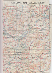 Geelong RSL Sub Branch
Silk Map - Asiatic Series, circa 1940s
... Silk Maps were produced by Great Britain and United States during WW2 some 3.5 million Silk Maps and cloth maps were produced for Allied Military Personnel....An oblong, cream colour silk map, Asiatic Series....AAF Cloth Map-Asiatic Series Side 1 - No 34 Southeast China Side 2 - No35 - Northeast China...Army Map Service US Army Washington DC...Geelong RSL Sub Branch 50 Barwon Heads Road Belmont geelong-and-the-bellarine-peninsula Silk Maps were produced by Great Britain and United States during WW2 some 3.5 million Silk Maps and cloth maps were produced for Allied Military Personnel. ...Silk Maps were produced by Great Britain and United States during WW2 some 3.5 million Silk Maps and cloth maps were produced for Allied Military Personnel.This Silk Map is an original map from the WW2 era.An oblong, cream colour silk map, Asiatic Series.AAF Cloth Map-Asiatic Series Side 1 - No 34 Southeast China Side 2 - No35 - Northeast Chinaww2, silk map, great britain, united states -
 National Vietnam Veterans Museum (NVVM)
Map, Map Cloth
... Map...Map Cloth...Map...Map...Cloth map of Western Pacific region noting countries and water currents around. map is double sided...National Vietnam Veterans Museum (NVVM) 25 Veterans Drive Newhaven phillip-island-and-the-bass-coast Map Cloth map of Western Pacific region noting countries and water currents around. map is double sided Map Cloth Map Map ...Cloth map of Western Pacific region noting countries and water currents around. map is double sidedmap -
 Ballarat Heritage Services
Map, Plancius's Map (Amsterdam), 1594, 1594
... Map...Plancius's Map (Amsterdam), 1594...map...Copy of a Dutch map published in Amsterdam. showing a large stretch of outhern land called Terra sustralis ...Copy of a map from 'A Short HIstory of Australia' by Ernest Scott....Ballarat Heritage Services PO Box 2209 Bakery Hill Post Office goldfields Copy of a Dutch map published in Amsterdam. showing a large stretch of outhern land called Terra sustralis map plascius placius's map terra australis dutch map Copy of a map from 'A Short HIstory of Australia' by Ernest Scott. ...Copy of a Dutch map published in Amsterdam. showing a large stretch of outhern land called Terra sustralis Copy of a map from 'A Short HIstory of Australia' by Ernest Scott.map, plascius, placius's map, terra australis, dutch map -
 Whitehorse Historical Society Inc.
Map, Map of Nunawading, 1950?
... Map...Map of Nunawading......Map...Map...Map of the entire City of Nunawading: complimentary map issued by Frank Fisher & Co real estate agents, Blackburn....Whitehorse Historical Society Inc. 2-10 Deep Creek Road Mitcham melbourne Nunawading Map Map of the entire City of Nunawading: complimentary map issued by Frank Fisher & Co real estate agents, Blackburn. ...Map of the entire City of Nunawading: complimentary map issued by Frank Fisher & Co real estate agents, Blackburn.Map of the entire City of Nunawading: complimentary map issued by Frank Fisher & Co real estate agents, Blackburn.Map of the entire City of Nunawading: complimentary map issued by Frank Fisher & Co real estate agents, Blackburn.nunawading, map -
Whitehorse Historical Society Inc.
Map, Blackburn and Nunawading Map, 1960's?
... Map...Blackburn and Nunawading Map...Map...Map of Blackburn and Nunawading....Map of Blackburn and Nunawading....Whitehorse Historical Society Inc. 2-10 Deep Creek Road Mitcham melbourne Map of Blackburn and Nunawading. Maps Blackburn Nunawading Map of Blackburn and Nunawading. ...Map of Blackburn and Nunawading.Map of Blackburn and Nunawading.Map of Blackburn and Nunawading.maps, blackburn, nunawading -
Federation University Historical Collection
Map, Robinson's Ballarat Street Map, c1972, 1970s
... Map...Robinson's Ballarat Street Map, c1972......map...Map...A coloured fold-out street map of Ballarat. It also includes a district road map....It also includes a district road map. Robinson's Ballarat Street Map, c1972 Map Map ...A coloured fold-out street map of Ballarat. It also includes a district road map.ballarat, map, ballarat streets -
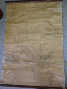
 Greensborough Historical Society
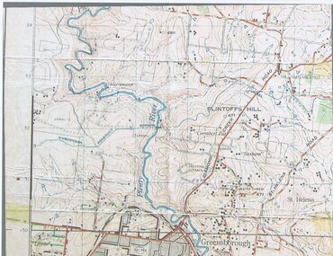
Map, John Monash, 1913 Map of Greensborough, 1913
... Map...1913 Map of Greensborough...Map...1913 Map of Greensborough, possibly by John Monash. ...Colour map showing land contours and place names...Greensborough - maps 1913 Colour map showing land contours and place names 1913 Map of Greensborough Map Map John Monash ...1913 Map of Greensborough, possibly by John Monash. This map shows the area to the north of the township.Colour map showing land contours and place namesgreensborough - maps, 1913 -
 National Vietnam Veterans Museum (NVVM)
Map, Map of Hue
... Map...Map of Hue...Map...Map...Folden up map of Hue with street names...National Vietnam Veterans Museum (NVVM) 25 Veterans Drive Newhaven phillip-island-and-the-bass-coast Map Hue Folden up map of Hue with street names Map of Hue Map Map ...Folden up map of Hue with street namesmap, hue -
 National Vietnam Veterans Museum (NVVM)
Map, C. 1969 - 70
... Map...Map...Map...Map...Colour map of Vietnam with military locations shown....Map Map Map ...Colour map of Vietnam with military locations shown.map, vietnam -
Federation University Historical Collection
Map, Map of Vitilevu showing vehicular roads, native tracks, villages, provinces, 1935
... Map...Map of Vitilevu showing vehicular roads, native tracks, villages, provinces...map...Map...Printed map on paper backed onto linen with small inset maps of Nandi and Singatoka ...map vitilevu singatoka nandi Printed map on paper backed onto linen with small inset maps of Nandi and Singatoka Map of Vitilevu showing vehicular roads, native tracks, villages, provinces Map Map ...Printed map on paper backed onto linen with small inset maps of Nandi and Singatoka map, vitilevu, singatoka, nandi -
 Ballarat Heritage Services
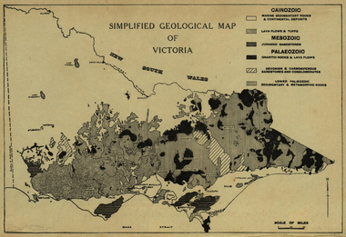
Map, Simplified Geological Map of Victoria, c1940, c1940
... Map...Simplified Geological Map of Victoria, c1940......map...Map...Physiographic map of Victoria....Simplified Geological Map of Victoria, c1940 Map Map ...Physiographic map of Victoria.victoria, map, geology, geological -
 Melbourne Tram Museum
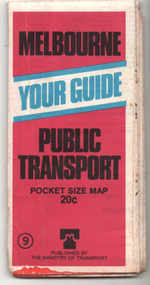
Ephemera - Map, Ministry of Transport, "Melbourne Your Guide PUblic Transport Pocket size map", 1979
... Map..."Melbourne Your Guide PUblic Transport Pocket size map"......map...Priced 20c, published 1979 as map No. 9...Fold out map (27 sections 9 across x 3 deep), coloured of Melbourne's Tram and Bus routes, route numbers, rail lines, detailed for the central part of Melbourne and insert section for Frankston. ...Priced 20c, published 1979 as map No. 9 Demonstrates the methodology of providing map and transport information at the time. ...Provided a detailed map of Melbourne's public transport, route number list and brief description. Has contact details for bookings and lost property etc. Priced 20c, published 1979 as map No. 9Demonstrates the methodology of providing map and transport information at the time.Fold out map (27 sections 9 across x 3 deep), coloured of Melbourne's Tram and Bus routes, route numbers, rail lines, detailed for the central part of Melbourne and insert section for Frankston. melbourne, map, tram and bus services, railways, mmtb, ministry of transport -
Whitehorse Historical Society Inc.
Map, Nunawading Map. Large Scale, 1960's ?
... Map...Nunawading Map. Large Scale...Map...Sheet 2, Nunawading map. Sections 78 -97....Sheet 2, Nunawading map. Sections 78 -97....Whitehorse Historical Society Inc. 2-10 Deep Creek Road Mitcham melbourne Sheet 2, Nunawading map. Sections 78 -97. Maps Nunawading Sheet 2, Nunawading map. ...Sheet 2, Nunawading map. Sections 78 -97.Sheet 2, Nunawading map. Sections 78 -97.Sheet 2, Nunawading map. Sections 78 -97.maps, nunawading -
 National Vietnam Veterans Museum (NVVM)
Map, Relief Map
... Map...Relief Map...Map...Map...Large scale map of Vietnam showing marked bounaries of provinces. ...Scale 1:250,000 Relief Map Map Map ...Large scale map of Vietnam showing marked bounaries of provinces. Scale 1:250,000Series L500 Sheet NE 49-13 Edition 3-AMSmap, aattv -
 Greensborough Historical Society
Map, Map of Greensborough - Jessop's Real Estate, 1930c
... Map...Map of Greensborough - Jessop's Real Estate...Map...This map of Greensborough hung in the office of Cec Jessop's Real Estate office corner Main and Grimshaw Street. ...Canvas roll-up map with timber rails top and bottom....Map of Greensborough - Jessop's Real Estate Map Map ...This map of Greensborough hung in the office of Cec Jessop's Real Estate office corner Main and Grimshaw Street. Includes a word document listing street name changes from the original map to today, according to Norm Colvin.This map was saved from the building when the business closed.Canvas roll-up map with timber rails top and bottom.greensborough - maps, cecil jessop, greensborough street names -
Victorian Aboriginal Corporation for Languages
Map, Geographic Data Victoria, Vicmap topographic map index as at June 2000, 2000
... Map...Vicmap topographic map index as at June 2000...Index to Vicmap topographic mapping, including 1:25 000 and 1:50 000 topographic maps, and Outdoor leisure series, compiled by the earlier bodies, Survey &? ...maps...Victorian Aboriginal Corporation for Languages 33 Saxon Street Brunswick melbourne Victorian maps topographic maps maps Index to Vicmap topographic mapping, including 1:25 000 and 1:50 000 topographic maps, and Outdoor leisure series, compiled by the earlier bodies, Survey &? ...Index to Vicmap topographic mapping, including 1:25 000 and 1:50 000 topographic maps, and Outdoor leisure series, compiled by the earlier bodies, Survey &? Mapping Victoria, etc. Also indexes Royal Australian Survey Corps' 1:50 000 topographic mapping.mapsvictorian maps, topographic maps -
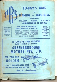 Greensborough Historical Society
Map, To-day's Map of Ivanhoe - Heidelberg; including Rosanna, McLeod, Watsonia, Greensborough to Eltham, 1937-1953
... Map...To-day's Map of Ivanhoe - Heidelberg; including Rosanna, McLeod, Watsonia, Greensborough to Eltham....Map...Map of the suburbs of Ivanhoe, Heidelberg, Rosanna, Macleod, Watsonia, Greensborough and Eltham. ...Fold out map in pale blue cover. Cover dimensions: 21.5x15cm. ...Map Map Regional Publicity Service ...Map of the suburbs of Ivanhoe, Heidelberg, Rosanna, Macleod, Watsonia, Greensborough and Eltham. Dates to mid 1950s. An Advertiser on this map may be found in the Hurstbridge Advertiser Friday 17 December 1937, page 7: "Lyon Bros, of Eltham garage, suggest in their advertisement on the front page of this issue. that motorists should have their cars checked over by them before Christmas, so that any 5mall defects which might militate against the pleasure of the trip, might be remedied." As does "The Montsalvat Plant Farm" in The Age of Saturday 5 September 1953, page 48.Shows early streets and open space in these areas.Fold out map in pale blue cover. Cover dimensions: 21.5x15cm. Map is surrounded by advertising for local businesses.ivanhoe, maps, heidelberg, rosanna, macleod, watsonia, greensborough, eltham -
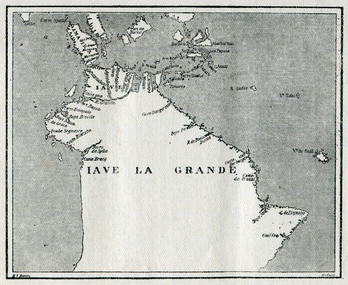 Ballarat Heritage Services
Map, Map of Java La Grande, 1542, 1542
... Map...Map of Java La Grande, 1542...map...Map...Copy of a map from 'A Short HIstory of Australia' by Ernest Scott....Map of Java La Grande, 1542 Map Map ...Copy of a map from 'A Short HIstory of Australia' by Ernest Scott.map, chart of the southland, hessel gerritsz, dutch discovery of australia -
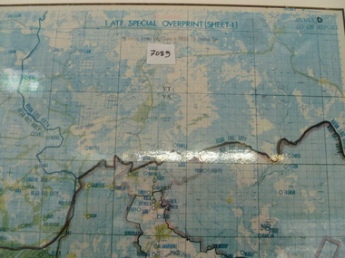 National Vietnam Veterans Museum (NVVM)
Map, 1 ATF Special Overprint (sheet 1) Map
... Map...1 ATF Special Overprint (sheet 1) Map...Map...Map...Framed map of 1 ATF operating area, operating bases and operational zones and firebases are detailed....National Vietnam Veterans Museum (NVVM) 25 Veterans Drive Newhaven phillip-island-and-the-bass-coast Map 1 ATF Firebases Framed map of 1 ATF operating area, operating bases and operational zones and firebases are detailed. 1 ATF Special Overprint (sheet 1) Map Map Map 29th Eng. ...Framed map of 1 ATF operating area, operating bases and operational zones and firebases are detailed.map, 1 atf, firebases