Showing 33 items matching " map of lines of reef and mines (bendigo)."
-
 Bendigo Historical Society Inc.
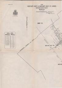
Map - DEBORAH MINE - MAP OF LINES OF REEF AND MINES (BENDIGO)
... DEBORAH MINE - MAP OF LINES OF REEF AND MINES (BENDIGO)...Mine... Map of Lines of Reef and Mines (Bendigo)....Two adjoining photocopies of part of map of Bendigo Goldfield showing lines of reef, mines, streets, locations and contour lines. ...History House 11 Mackenzie Street Bendigo goldfields MINE Gold deborah mine Deborah Mine Map of Lines of Reef and Mines (Bendigo). ...Two adjoining photocopies of part of map of Bendigo Goldfield showing lines of reef, mines, streets, locations and contour lines. Map is a beige colour with darker lines and letters. Some of the mines have their depths printed beside them. This item is stored in Map drawer 7mine, gold, deborah mine, deborah mine, map of lines of reef and mines (bendigo). -
 Bendigo Historical Society Inc.
Document - MCCOLL, RANKIN AND STANISTREET COLLECTION: SUNDRY REPORTS, 1930's
... Manilla Folder containing reports from various mines in Bendigo and surrounding areas. 1. 4 page typewritten report on the Balaclava Hill Mine at Rushworth and some newspaper clippings about the mine with a plan of the underground workings; 2. ...Manilla Folder containing reports from various mines in Bendigo and surrounding areas. 1. 4 page typewritten report on the Balaclava Hill Mine at Rushworth and some newspaper clippings about the mine with a plan of the underground workings; 2. ...Manilla Folder containing reports from various mines in Bendigo and surrounding areas. 1. 4 page typewritten report on the Balaclava Hill Mine at Rushworth and some newspaper clippings about the mine with a plan of the underground workings; 2. Page from the Árgus' dated 2nd August 1900 featuring an article on the survey of the Garden line of Reefs; 3. 5 page report with maps on the Tooleen Gold Field; 4. Single page report about an unnamed mining area claimed to be on the southern end of the Deborah line of reef. (this could be the 'Three Jays' mine in Sedgwick. P. Wilkin); 5. Hand written report on the Coronation Mine, 2 miles east of Walhalla.; 6. Hand written report dated 1935, of the Queen Mary mine, St. Arnaud.; 7. 1932 report on the North Neangar lease.; 8 4 page report on the Kings Prize Gold Mining Syndicate.; 9. Description of the plant of the Marong Alluvial Company? Also a guide for marking out leases.; 10. Crushing details (1 page) from the 'Enterprise' Mine South of and adjacent to Perseverence.; 11. 1 page crushing details from Rowe Brothers, Mosquito Mine, Fryerstown.; 12 hand written report mentions Arthur Hatfield, Scarsdale.; 13. Map with lines of reef showing the position of the New Moon Consolidated and the New Moon United shafts.; 14, Large scale map from Harrison/Victoria street to Havilah Road showing the positions of the Carlisle, North Garden and Unity Shafts.gold mining, miners' safety cage, sundry reports, mining. bendigo, rushworth, balaclava hill, garden line of reef, toolleen, coronation mine, walhalla, queen mary mine, st. arnaud. north neangar, kings prize gold mining syndicate, marong, enterprise mine, perseverence, rowe brothers, mosquito mine, fryerstown, arthur hatfield, scarsdale, new moon consolidate, new moon united, carlisle, north garden, unity. -
 Bendigo Historical Society Inc.
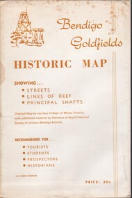
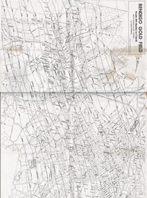
Document - BENDIGO GOLFIELDS HISTORIC MAP
... Bendigo goldfields historic map showing streets, lines of reef, principal shafts. Original map (dept of Mines) with additional material by members of RHSV (Bendigo Branch) . ...History House 11 Mackenzie Street Bendigo goldfields Bendigo map goldfields mines tourism Bendigo goldfields historic map showing streets, lines of reef, principal shafts. ...Bendigo goldfields historic map showing streets, lines of reef, principal shafts. Original map (dept of Mines) with additional material by members of RHSV (Bendigo Branch) . Price 30c. Map; is folded into envelope for sale and storage.bendigo, map, goldfields, mines, tourism -
 Bendigo Historical Society Inc.
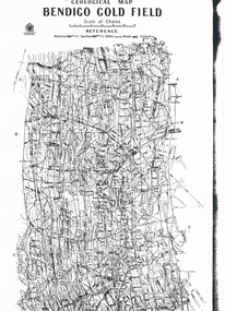
Map - LONG GULLY HISTORY GROUP COLLECTION: GEOLOGICAL MAP - BENDIGO GOLD FIELD
... Map shows Lines of Reef, Anticlines, Synclines, Shafts, Alluvial Contours Gullies and some street names. ...Copy of a Geological Map of the Bendigo Gold Field. Map shows Lines of Reef, Anticlines, Synclines, Shafts, Alluvial Contours Gullies and some street names. Copy is hard to read. There are two pages.bendigo, history, long gully history group, the long gully history group - geological map - bendigo gold field, mines department, h herman, lightning hill line, hustlers line, derby line, paddy's gully line, garden gully line, deborah line, sheepshead line, new chum line, nell gwynne line, british and foreign line, napoleon line, carshalton line, thistle line, christmas line, lancashire line -
 Bendigo Historical Society Inc.
Map - MINING PLAN ,VICTORIA HILL AREA, No date visible
... History House 11 Mackenzie Street Bendigo goldfields MAP Bendigo mining plan Mining Gold Mines Victoria Hill Lines of Reef Map: Large scale plan of an area of the Goldfield, Northward from Barnard Street, covering the Victoria Hill area. ...Map: Large scale plan of an area of the Goldfield, Northward from Barnard Street, covering the Victoria Hill area. Black printing on polycarbonate film. Transparent.map, bendigo, mining plan, mining, gold mines, victoria hill, lines of reef -
 Bendigo Historical Society Inc.
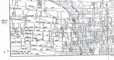
Map - LONG GULLY HISTORY GROUP COLLECTION: MAP OF REEFS AND MINES
... Two pages with lines of reef and mines from Spring Gully Reservoir to north of the Eaglehawk Railway Station. Shown on the map are the lines of reef, the Thistle, Carshalton, Napoleon, British & Foreign, Nell Gwynne, New Chum, Sheepshead, Deborah, Garden Gully, Paddy's Gully, Derby, Miller's, Hustlers, Lightning Hill, Myers Flat, Lancashire, Cook's, Maiden Gully, Johnson's and Millers. ...History House 11 Mackenzie Street Bendigo goldfields BHS Collection BENDIGO History long gully history group The Long Gully History Group - Map of Reefs and Mines Spring Gully Reservoir Thistle Carshalton Napoleon British & Foreign Nell Gwynne New Chum Sheepshead Deborah Garden Gully Paddy's Gully Derby Miller's Hustlers Lightning Hill Myers Flat Lancashire Cook's Maiden Gully Johnson's Millers Golden Square Railway Station Bendigo Railway Station Eaglehawk Railway Station Two pages with lines of reef and mines from Spring Gully Reservoir to north of the Eaglehawk Railway Station. ...BHS CollectionTwo pages with lines of reef and mines from Spring Gully Reservoir to north of the Eaglehawk Railway Station. Shown on the map are the lines of reef, the Thistle, Carshalton, Napoleon, British & Foreign, Nell Gwynne, New Chum, Sheepshead, Deborah, Garden Gully, Paddy's Gully, Derby, Miller's, Hustlers, Lightning Hill, Myers Flat, Lancashire, Cook's, Maiden Gully, Johnson's and Millers. Also shown are the Golden Square, Bendigo and Eaglehawk Railway Stations as well as the hills.bendigo, history, long gully history group, the long gully history group - map of reefs and mines, spring gully reservoir, thistle, carshalton, napoleon, british & foreign, nell gwynne, new chum, sheepshead, deborah, garden gully, paddy's gully, derby, miller's, hustlers, lightning hill, myers flat, lancashire, cook's, maiden gully, johnson's, millers, golden square railway station, bendigo railway station, eaglehawk railway station -
 Bendigo Historical Society Inc.
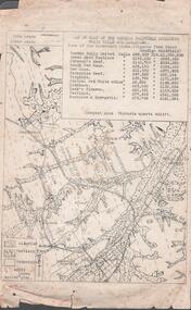
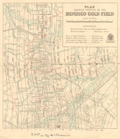
Plan - Garden Gully and New Moon Lines of Reef, J.B. Young, lithographer, Unknown
... map, a table of information headed ' Several of the undermentioned Companies have paid considerable sums in Dividends prior to the re-registration under the No Liability portion of the Act'. Table contains information on the name of Company; No. of shares; nominal capital,; Capital called up; call per share; dividends; machinery; present depth of shaft; bottom plat; Legal Managers; address. On bottom of table, 'Beehive Chambers, Bendigo 6/8/03'. Plan shows mines along the reef lines...map, a table of information headed ' Several of the undermentioned Companies have paid considerable sums in Dividends prior to the re-registration under the No Liability portion of the Act'. Table contains information on the name of Company; No. of shares; nominal capital,; Capital called up; call per share; dividends; machinery; present depth of shaft; bottom plat; Legal Managers; address. On bottom of table, 'Beehive Chambers, Bendigo 6/8/03'. Plan shows mines along the reef lines ...Printed on buff coloured light paper, written on top centre of plan: ' Northern Portion of Garden Gully & New Moon Line of Reefs, Eaglehawk, Bendigo, Scale 8 chains to an inch'. Printed on right hand side of reef names: ' Issued by Wood And McNair, Sharebrokers, Beehive Chambers, Bendigo and High Street, Eaglehawk. J.B. Young, Lith. Bendigo.' On far right hand end of map, a table of information headed ' Several of the undermentioned Companies have paid considerable sums in Dividends prior to the re-registration under the No Liability portion of the Act'. Table contains information on the name of Company; No. of shares; nominal capital,; Capital called up; call per share; dividends; machinery; present depth of shaft; bottom plat; Legal Managers; address. On bottom of table, 'Beehive Chambers, Bendigo 6/8/03'. Plan shows mines along the reef lines with distance in yards of each claim - from SSW direction: Golden Pyke Company, McDuff Amalgamated, Constellation Company, Virginia Company, Specimen Hill Company, New Hopeful, New Argus Company, Clarence Company, North Argus Company, South New Moon Company, New Moon Company, Suffolk Tribute Company, North New Moon Company, New Moon Consolidated Company, New Moon United Company, Adelaide New Moon Company, J. Davies, Day & Co., (lease applied for by P. Booth), P. Booth, D. Murdoch, J. Mani, F. Bassett and R. Bassett. Mine map is part of the Margaret Roberts Collection. gold mining, gold, margaret roberts collection, garden gully, new moon, reef lines, golden pyke company, mcduff amalgamated, constellation company, virginia company, specimen hill company, new hopeful, new argus company, clarence company, north argus company, south new moon company, new moon company, suffolk tribute company, north new moon company, new moon consolidated company, new moon united company, adelaide new moon company, j. davies, day & co., (lease applied for by p. booth), p. booth, d. murdoch, j. mani, f. bassett and r. bassett. -
 Bendigo Historical Society Inc.
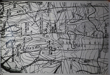
Map - Geological survey of Bendigo Goldfields
... maps of the Bendigo Gold Fields joined together. The three sections are Eaglehawk, Golden Square and Spring Gully. It shows geological conditions, gold reef lines and mine sights. ...maps of the Bendigo Gold Fields joined together. The three sections are Eaglehawk, Golden Square and Spring Gully. It shows geological conditions, gold reef lines and mine sights. ...Three Geological survey maps of the Bendigo Gold Fields joined together. The three sections are Eaglehawk, Golden Square and Spring Gully. It shows geological conditions, gold reef lines and mine sights. Three sections are laminated together. The maps were produced by the Victorian Department of Manufacturing and Industry Development geological survey, bendigo gold fields -
 Bendigo Historical Society Inc.
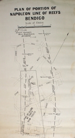
Plan - Part of Napoleon and Nell Gwynne Reefs
... Black printing on off white colored paper- PLAN OF PORTION OF NAPOLEON LINE OF REEFS BENDIGO, Scale of Chains, a signature, District Geologist Mines Department BENDIGO. 5/12/39 Two vertical broken lines are labeled NAPOLEON LINE OF REEFS, NELL GYWNNE LINE OF REEFS and CENTRAL NAPOLEON LODE CHANNEL and mine shafts CENTRAL NAPOLEON, MOONTA, PTOPOSED NEW SHAFT, NORTH NEW GWYNNE, THREE TOMS, NEW CHUM SYNCLINE and CENTRAL NELL GWYNNE are drawn over a street map of the Long Gully area. ...Caldwell, Officer in charge of the Bendigo Geological branch of the Victorian Mines Department, received his early training in the Castlemaine and Bendigo Schools of Mines and later at the Melbourne Technical College Bendigo Margaret Roberts gold Map Mine Long Gully J.J. ...Mr. J. J. Caldwell, Officer in charge of the Bendigo Geological branch of the Victorian Mines Department, received his early training in the Castlemaine and Bendigo Schools of Mines and later at the Melbourne Technical CollegeBlack printing on off white colored paper- PLAN OF PORTION OF NAPOLEON LINE OF REEFS BENDIGO, Scale of Chains, a signature, District Geologist Mines Department BENDIGO. 5/12/39 Two vertical broken lines are labeled NAPOLEON LINE OF REEFS, NELL GYWNNE LINE OF REEFS and CENTRAL NAPOLEON LODE CHANNEL and mine shafts CENTRAL NAPOLEON, MOONTA, PTOPOSED NEW SHAFT, NORTH NEW GWYNNE, THREE TOMS, NEW CHUM SYNCLINE and CENTRAL NELL GWYNNE are drawn over a street map of the Long Gully area. The streets shown are; Empire Rd, Harvey St, Inglis St, Wells St, Union St, Alley St (now Marong Rd) and Curnow St. Forms part of the Margaret Roberts Collection bendigo, margaret roberts, gold, map, mine, long gully, j.j. caldwell -
 Bendigo Historical Society Inc.
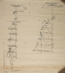
Plan - Monument Hill Co and Deborah Gold Mines Co
... The Deborah Glod Mines Co Bendigo drawing has five cross sections down to 740 feet. ...OBITUARY MR. W. H. CUNDY PROMINENT FOOTBALLER. The news of the death in a private hospital at Bendigo (VIC.) on Monday of Mr. William Henry Cundy, a geologist and mining engineer, who was regarded as one of the greatest authorities on the Bendigo gold field, was received in Launceston with deep regret. A native of Hobart, Mr. Cundy, who was 71 years of age, went to Bendigo from Tasmania in 1893 to an appointment in the Mines Department, subsequently, in association with Mr. E. J. Dunn, undertaking the task of making a special report on the Bendigo gold fields, and also of charting the lines of reef. He was keenly interested in mining ventures in Tasmania, and his services were in constant demand to investigate and report on shows, particularly gold and tin. In his younger days, at Hobart, Mr. Cundy was a champion footballer, and brought about the modification of the rules of the game in Tasmania. While in Bendigo he was captain of Sandhurst for many years, and a past-president of the Bendigo Football League. He was a widower. Mercury (Hobart, Tas.: 1860 - 1954), Friday 15 February 1935, page 6) A draftsman's drawing on off-white paper of cross sections labeled MONUMENT HILL Co and DEBORAH GOLD MINES Co BENDIGO. The Monument Hill drawing has seven cross sections down to 820 feet. The Deborah Glod Mines Co Bendigo drawing has five cross sections down to 740 feet. Both drawings are singed W H Cundy, July 1934. Forms part of the Margaret Roberts Collection bendigo, margaret roberts, gold, map, mine, w h cundy, deborah gold mines, monument hill co -
 Bendigo Historical Society Inc.
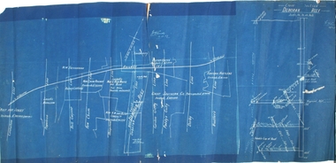
Plan - Deborah Reef, 19th December, 1917
... History House 11 Mackenzie Street Bendigo goldfields gold mining gold Bendigo Whip and Jersey Carshalton Napoleon Nell Gwynne New Chum Sheepshead Garden Gully Paddy Gully Derby Hustlers. Deborah railway line Deborah Gold Mine Deborah Reef cross section N. ...Blue paper map, white text and plan, showing reef lines. Same plan as 11270.71, with addition of Deborah Reef cross section, on extreme right of plan. N. Cundy, 19.12.17gold mining, gold, bendigo, whip and jersey, carshalton, napoleon, nell gwynne, new chum, sheepshead, garden gully, paddy gully, derby, hustlers., deborah, railway line, deborah gold mine, deborah reef, cross section -
 Bendigo Historical Society Inc.
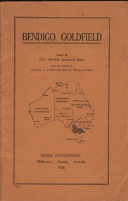
Book - BENDIGO GOLDFIELD
... Contains information on the geology of the Bendigo goldfield and major lines of reef and mines. Map of goldfield showing reef lines and mines attached to back cover....Contains information on the geology of the Bendigo goldfield and major lines of reef and mines. Map of goldfield showing reef lines and mines attached to back cover. ...booklet, 51 pages. 'Bendigo Goldfield' issued by Geo Brown, Secretary for Mines. Mines Department 1936. Contains information on the geology of the Bendigo goldfield and major lines of reef and mines. Map of goldfield showing reef lines and mines attached to back cover.bendigo, mining, bendigo goldfield -
 Bendigo Historical Society Inc.
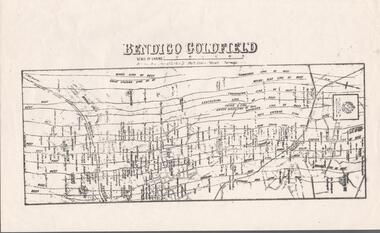
Map - BENDIGO GOLDFIELDS MAP
... Map of the Bendigo Goldfield, showing reef lines, mines and significant geographical features such as Monument Hill, Quartz Hill and Diamond Hill. ...History House 11 Mackenzie Street Bendigo goldfields BENDIGO Mining bendigo goldfields Map of the Bendigo Goldfield, showing reef lines, mines and significant geographical features such as Monument Hill, Quartz Hill and Diamond Hill. ...Map of the Bendigo Goldfield, showing reef lines, mines and significant geographical features such as Monument Hill, Quartz Hill and Diamond Hill. On the back of map 'Department of Mines, Victoria. Plan of Bendigo Goldfield.bendigo, mining, bendigo goldfields -
Bendigo Historical Society Inc.
Map - SECTIONS ACROSS BENDIGO GOLDFIELD
... Map in three sections showing sections across Bendigo Gold Field, showing anticlines, synclines, faults, stratigraphical zones and mines along the reef lines. ...History House 11 Mackenzie Street Bendigo goldfields BENDIGO Gold mining reef line maps Geological Survey of Victoria Map in three sections showing sections across Bendigo Gold Field, showing anticlines, synclines, faults, stratigraphical zones and mines along the reef lines. ...Map in three sections showing sections across Bendigo Gold Field, showing anticlines, synclines, faults, stratigraphical zones and mines along the reef lines. Key shows rock types Castlemaine, Bendigo B1, B2, B3 and B4, and Lancefieldian. First part of map shows sections A-A, B-B and C-C. Reef lines drawn with mines listed: Fault line shown are the Carshalton, Stafford, New Chum, Virginia and Clarence. A datum line shows 600 ft above sea level. On bottom of plan: ' Prepared in the Geological Survey Office, Bendigo, under the direction of H. Herman, late Director of Geological Survey, from surveys by H.S. Whitelaw, Field Geologist, assisted by E.S. Usher, A.J.J. Moore and R.A. Keble.' Second section of map shows sections D-D, and E-E. Fault lines listed are the Tambour Major fault, Carshalton fault, Stafford fault, Nell Gwynne fault, New Chum fault, Deborah fault. Third section shows sections F-F and G-G. Fault lines listed are the Bird Reef fault, Kangaroo Gully fault, Langdon fault, Carshalton fault, Nell Gwynne fault, Spring Gully fault, Hustlers fault, Gravel Hill fault, Ordes fault, Thanet fault. This map forms part of the Geological Survey of Victoria, Structure of Bendigo Goldfield report, No. 47, 1923. H.Herman, late Director of Geological Survey.Geological Survey of Victoriabendigo, gold mining, reef line maps -
Bendigo Historical Society Inc.
Map - BENDIGO GOLDFIELD VERTICAL PROJECTIONS
... Map of Bendigo Gold Field in two sections showing 'vertical projections along several anticlinal axial planes showing pitch, stratigraphical zones, faultlines, shafts and etc.'. Bulletin No 47 written top left hand side. Lines of reef...Lines of reef described: Christmas line Lancashire line Nell Gwynne line New Chum line Hustlers line Garden Gully line Sheepshead line Mines along the reef lines are listed. This map ...Map of Bendigo Gold Field in two sections showing 'vertical projections along several anticlinal axial planes showing pitch, stratigraphical zones, faultlines, shafts and etc.'. Bulletin No 47 written top left hand side. Lines of reef described: Christmas line Lancashire line Nell Gwynne line New Chum line Hustlers line Garden Gully line Sheepshead line Mines along the reef lines are listed. This map forms part of the Geological Survey of Victoria, Structure of Bendigo Goldfield report, No. 47, 1923. H.Herman, late Director of Geological Survey. On bottom of second section : Prepared in the Geological Survey Office, Bendigo, under the direction of H. Herman, late Director of Geological Survey, from surveys by H.S. Whitelaw, Field Geologist, assisted by E.S. Usher, A.J.J. Moore and R.A. Keble.Geological Survey of Victoriabendigo, gold mining, reef lines -
 Bendigo Historical Society Inc.
Map - STRUGNELL COLLECTION: HUSTLER'S LINE OF REEF, September 1913
... MAP Bendigo hustler's reef & hustler's reef 1 Underground Survey Office, Bendigo. Map, Hustler's Line of Reefs, Hustler's Reef & Hustler's Reef No.1 Mines Bendigo.Plate No. X1V (14) Comet Co. .Bulletin No 33 Signed H.A.Whitelaw. Drawing shows reef boundary lines ...Map, Hustler's Line of Reefs, Hustler's Reef & Hustler's Reef No.1 Mines Bendigo.Plate No. X1V (14) Comet Co. .Bulletin No 33 Signed H.A.Whitelaw. Drawing shows reef boundary lines .There is an explanatory box showing depth in feet and inches of the mines .Underground Survey Office, Bendigo.map, bendigo, hustler's reef & hustler's reef 1 -
 Bendigo Historical Society Inc.
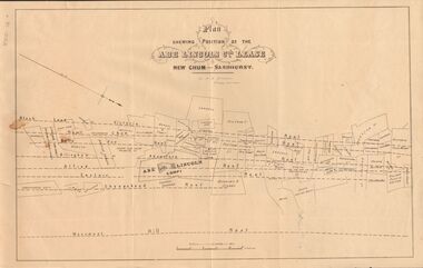
Document - MARKS COLLECTION: ABE LINCOLN CO LEASE
... BENDIGO Mining abe lincoln lease Two copies of plan for Abe Lincoln Co. Lease, New Chum, Sandhurst. One original, one copy. On top of plan 'Plan Showing Position of the Abe Lincoln Co. Lease, New Chum, Sandhurst' under name 'by H.B. Nicholas, Mining Surveyor' Sheepshead Reef, Easter reef, Alfred Reef, Allingham Reef,Adventure Reef, Belle Vue Reef, New Chum Reef, Black Lead, Victoria Reef lines shown on map with mine leases marked. ...Two copies of plan for Abe Lincoln Co. Lease, New Chum, Sandhurst. One original, one copy. On top of plan 'Plan Showing Position of the Abe Lincoln Co. Lease, New Chum, Sandhurst' under name 'by H.B. Nicholas, Mining Surveyor' Sheepshead Reef, Easter reef, Alfred Reef, Allingham Reef,Adventure Reef, Belle Vue Reef, New Chum Reef, Black Lead, Victoria Reef lines shown on map with mine leases marked. On bottom of map 'Monument Hill Reef' line marked.bendigo, mining, abe lincoln lease -
 Bendigo Historical Society Inc.
Document - MINING REPORTS - MAP OF PART OF THE BENDIGO GOLDFIELD INCLUDING WHITE HILLS AND EAGLEHAWK
... Map of part of the Bendigo Goldfield including White Hills and Eaglehawk. Map shows reef lines, gullies, railway line, tram route, type of rock, name of mine, Calls and Dividends. ...History House 11 Mackenzie Street Bendigo goldfields BHS Collection DOCUMENT Gold mining reports Mining Reports Map of Part of the Bendigo Goldfield including White Hills and Eaglehawk Pabst Bendigo Goldfield Garden Gully United Great Ext'd Hustlers Johnson's Reef South New Moon New Moon Catherine Reef Virginia Central Red White & Blue Ironbark Kock's Pioneer Carlisle Hercules & Energetic. Victoria Quartz Map of part of the Bendigo Goldfield including White Hills and Eaglehawk. Map shows reef lines ...BHS CollectionMap of part of the Bendigo Goldfield including White Hills and Eaglehawk. Map shows reef lines, gullies, railway line, tram route, type of rock, name of mine, Calls and Dividends. Also Deepest Mine Victoria Quartz 4614 ft. Names of Mines are Garden Gully United, Great Ext'd Hustlers, Johnson's Reef, South New Moon, New Moon, Catherine Reef, Virginia, Central Red White & Blue, Ironbark, Kock's Pioneer, Carlisle and the Hercules & Energetic. Map is part of the Albert Richardson Collection of mining documents and research. document, gold, mining reports, mining reports, map of part of the bendigo goldfield including white hills and eaglehawk, pabst bendigo goldfield, garden gully united, great ext'd hustlers, johnson's reef, south new moon, new moon, catherine reef, virginia, central red white & blue, ironbark, kock's pioneer, carlisle, hercules & energetic. victoria quartz -
 Bendigo Historical Society Inc.
Document - TYSON'S LINE - EASTERN LINES
... History House 11 Mackenzie Street Bendigo goldfields BHS Collection MINING Parish Map Tyson's Line Eastern Lines Hustler's New Chum Slaughteryard Line Lightning Hill Tyson's Isabella Mine Ironstone Hill Reef Nicholson Reef Mr Stevenson Aust Min Stand 1 June 1899 Typed carbon copy and typed copy of General notes on the lines East of the Hustlers. ...BHS CollectionTyped carbon copy and typed copy of General notes on the lines East of the Hustlers. Lines mentioned are: Hustler's, New Chum, Lightning Hill, Tysons, Slaughteryard, Isabella Mine, Ironstone Hill Reef, Nicholson Reef, on which a mine owned by a man named Stevenson mined a fair amount of gold. Ref. Anon; 1899. Spec. Ed. Aust. Min. Stand. June 1st 1899: p 61. Notes prepared by Albert Richardson.mining, parish map, tyson's line, eastern lines, hustler's, new chum, slaughteryard line, lightning hill, tyson's, isabella mine, ironstone hill reef, nicholson reef, mr stevenson, aust min stand 1 june 1899 -
 Bendigo Historical Society Inc.
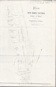
Map - NEW CHUM & VICTORIA LINES OF REEF - PLAN OF NEW CHUM & VICTORIA LINES OF REEF
... Lines of Reef, compiled by G. W. Hart. Taken from J. N. Macartney's G'Fields Registry for 1871. Plan shows leases from High Street to California Gully. Location of the Manchester Arms, British & American Hotel and the Quartz Miners Arms are shown. Townships of Long Gully and Ironbark are shown. Map ...Two pages of a Plan of New Chum & Victoria Lines of Reef, compiled by G. W. Hart. Taken from J. N. Macartney's G'Fields Registry for 1871. Plan shows leases from High Street to California Gully. Location of the Manchester Arms, British & American Hotel and the Quartz Miners Arms are shown. Townships of Long Gully and Ironbark are shown.map, goldfields, new chum & victoria lines of reef, victoria catharine g m coy, thornton & co, extd victoria reef g m co, ural tribute compy, nil desperandum compy, koch, north victoria g m co, danger hill coy, north endeavour coy, wheadon & co, pilot co, north energetic co, energetic compy, endeavour company, hercules co, victoria gold mines compy, iron duke g m co, golden fleece united, ballerstedt, alfred co, confidence co, prince alfred co, canterbury co, advance co, wells, humboldt co, adventure co, try me well, sterry & co, gibbs & ballerstedt, handy andy, wells?, south adventure co, w rae, victoria reef quartz m co, myra co, jackson, wybrants, burrows & sterry, new chum & victoria tribute, old chum co, ballerstedt, lazarus, watson, koch & hildebrand, lansell & hunt, dennis, abe lincoln co, bonati & co, ellesmere co, moore late menzies, british co, british tribute co, garibaldi, c c co, new chum trib, dobson & co, young chum co, little chum co, old chum co, new chum trib, little chum trib, g w hart, j n macartney's g'fields registry for 1871, manchester arms, british & american, quartz miners arms -
 Bendigo Historical Society Inc.
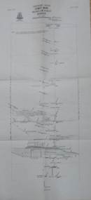
Map - COMET MINE - LONGITUDINAL SECTION COMET MINE
... Longitudinal section of the Comet Mine on the Hustler's Line of Reef Bulletin No 33, Plate No XXVI signed by H. S. Whitelaw, Underground Survey Office Bendigo, September 1913. ...History House 11 Mackenzie Street Bendigo goldfields MINING Parish Map Hustler's Line of Reef Longitudinal Section of Comet Mine Bulletin No 33 Plate No XXVI H S Whitelaw Geological Survey of Victoria Longitudinal section of the Comet Mine on the Hustler's Line of Reef Bulletin No 33, Plate No XXVI signed by H. ...Longitudinal section of the Comet Mine on the Hustler's Line of Reef Bulletin No 33, Plate No XXVI signed by H. S. Whitelaw, Underground Survey Office Bendigo, September 1913. Map shows datum lines, depths of levels, approximate boundaries and references to other plans. Note - Plates 4, 8, 13, 20, 26 and 31 form a Longitudinal Section from Fortuna Hustler's to Hustler's Consols Mine. Geological Survey of Victoriamining, parish map, hustler's line of reef, longitudinal section of comet mine bulletin no 33 plate no xxvi, h s whitelaw -
 Bendigo Historical Society Inc.
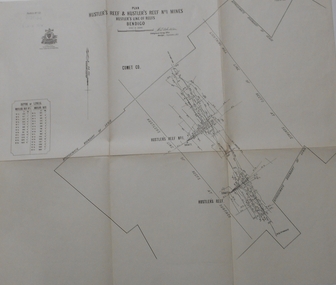
Map - HUSTLER'S REEF & HUSTLER'S REEF NO 1 MINES - PLAN OF THE HUSTLER'S REEF & HUSTLER'S REEF NO 1 MINES
... Plan of the Hustler's Reef & Hustler's Reef No 1 Mines on the Hustler's Line of Reefs, Bendigo Bulletin No 33, Plate No XIV. ...History House 11 Mackenzie Street Bendigo goldfields MINING Parish Map Hustler's Reef & Hustler's Reef No 1 Mines Hustler's Line of Reefs Lightning Hill Line of Reefs Comet Co. ...Plan of the Hustler's Reef & Hustler's Reef No 1 Mines on the Hustler's Line of Reefs, Bendigo Bulletin No 33, Plate No XIV. No 8 connecting No 10 (Hustler's Reef), No 11 connecting No 13 (Hustler's Reef), No 13 (Hustler's Reef No 1) connecting No 15 (Hustler's Reef) and No 10 Hustler's Reef No 1 rise to Comet Mine. Map shows different levels in relation to the two shafts, the lines of the Hustler's Line of Reefs and the Lightning Hill Line of Reefs, the approximate Boundary of Lease and the Comet Co., the adjoining lease. Table on the left shows the levels and their depths of the two mines. Signed by H A Whitelaw, Underground Survey Office, Bendigo, September 1913. Geological Survey of Victoria emblem. mining, parish map, hustler's reef & hustler's reef no 1 mines, hustler's line of reefs lightning hill line of reefs, comet co., h a whitelaw, underground survey office bendigo, geological survey of victoria -
 Bendigo Historical Society Inc.
Map - BENDIGO GOLDFIELD MAP
... Two not very clear copies of the Bendigo Goldfield Map. Streets, Railway Line, Lines of Reefs and mines are shown. ...History House 11 Mackenzie Street Bendigo goldfields MAP Bendigo goldfields Bendigo Goldfield Map Lines of Reefs Dept. of Mines Victoria Two not very clear copies of the Bendigo Goldfield Map. ...Two not very clear copies of the Bendigo Goldfield Map. Streets, Railway Line, Lines of Reefs and mines are shown. Dept. of Mines, Victoria printed on the map. Shows reefs from Bird's Line of Reefs to Lightning Hill Line of Reef.map, bendigo, goldfields, bendigo goldfield map, lines of reefs, dept. of mines victoria -
Bendigo Historical Society Inc.
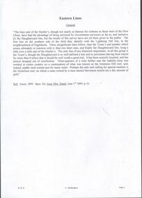
Map - HUSTLER'S & CHRISTMAS LINES OF REEFS - PLAN OF LINES OF SECTION OF REEFS
... Underground Survey of Mines Bendigo. Plan of Cross Section Lines Shewing Connections with Trigonometrical Stations and Base Lines. 13/3/99 Signed ? ...History House 11 Mackenzie Street Bendigo goldfields MINING Parish Map Hustler's & Christmas Lines of Reefs Plan of Lines of Section of Reefs ? ...Underground Survey of Mines Bendigo. Plan of Cross Section Lines Shewing Connections with Trigonometrical Stations and Base Lines. 13/3/99 Signed ? Stirling. Places and mines mentioned Speciman Hill, Tambour Major, Lansell's 180, Victory and Pandora, Great Extended Hustler's, Windmill Hill on Victoria Reef. Next part of map is a Plan of Lines of Section between the Hustler's and Christmas Lines of Reefs. 8/3/99. Signed ?. Transverse Section. Shows Tambour Major Co., near the Christmas Line of Reef, Crosscuts and their depth, geological features and stone encountered. Then shows Thistle Line, Charshalton Line, Napoleon Line, Nell Gwynne Line, New Chum Line, Lansell's No 180 with levels, depths and geological features. Drawing is continued in three parts to fit on paper. Lansell's East Shaft with levels and depths, geological features and stone encountered. Sheepshead Line, Old Shaft, Garden Gully Line, Victory and Pabndora Co with crosscuts, depths, geological features and stone encountered. Paddy's Gully Line, Derby Line, Millers Line, Hustler's Line, Great Extended Hustler's Co with levels, depths, geological features and stone encountered. A note beside a Saddle Reef: 360,000 pounds paid in dividends from this reef. Average ounces per ton gold noted where found. Reference Table for stone and geological features. Datum Line 700 feet above Sea Level Unscannedmining, parish map, hustler's & christmas lines of reefs, plan of lines of section of reefs, ? stirling, specimen hill, tambour major, lansell's 180, victory & pandora, great extended hustler's, windmill hill, victoria reef, tambour major co, christmas line, hustler's line, thistle line, carshalton line, napoleon line, nell gwynne line, new chum line, lansell's no 180, lansell's east shaft, sheepshead line, old shaft, garden gully line, paddy's gully line, derby line, miller's line, hustler's line, great extended hustler's co -
 Bendigo Historical Society Inc.
Map - BENDIGO GOLD FIELD - MAP OF PORTION OF THE BENDIGO GOLD FIELD
... Map showing portion of the Bendigo Gold Field showing Alluvial working, shaft sites , streets and lines of reefs.Department of Mines, Victoria. Many mines, lines of reefs...History House 11 Mackenzie Street Bendigo goldfields DOCUMENT Bendigo Gold Field Department of Mines Lines of Reefs Gullies Mines Map showing portion of the Bendigo Gold Field showing Alluvial working, shaft sites , streets and lines of reefs.Department of Mines, Victoria. ...Map showing portion of the Bendigo Gold Field showing Alluvial working, shaft sites , streets and lines of reefs.Department of Mines, Victoria. Many mines, lines of reefs and gullies are on the map. Blue Royal Historical Society of Victoria Bendigo Branch stamp on the back.document, bendigo gold field, department of mines, lines of reefs, gullies, mines -
 Bendigo Historical Society Inc.
Map - MAP OF BENDIGO GOLDFIELDS
... Copy of a map of the Bendigo Goldfields issued by the Dept. of Mines showing lines of reef, mines and streets. ...History House 11 Mackenzie Street Bendigo goldfields MAP Bendigo goldfields Map Goldfields Department of Mines Map. Copy of a map of the Bendigo Goldfields issued by the Dept. of Mines showing lines of reef, mines and streets. ...Map. Copy of a map of the Bendigo Goldfields issued by the Dept. of Mines showing lines of reef, mines and streets. Scale 20 chains to 1 inch. Printed by Cambridge Press, Bendigo. Date unknownmap, bendigo, goldfields, map, goldfields, department of mines -
 Bendigo Historical Society Inc.
Map - DEPARTMENT OF MINES VICTORIA : PLAN SHOWING PORTION OF THE BENDIGO GOLD FIELD
... Bendigo High - see donation notes). Across the bottom of the map is written ' M. Hill cr. Myrtle & Barnard' .The named reef lines have been numbered with ink across the bottom of the map. The gullies have been coloured with green pencil and a red pencil line is drawn through the western side of the map. Additional information: anticlinal axial lines at surface, alluvial workings, shaft sites, area of Main Goldfield, Deepest mine...History House 11 Mackenzie Street Bendigo goldfields BENDIGO Gold mining Bendigo Gold Field. Gold Mining. Tyler J. J. Department of Mines Victoria. ...Department of Mines Victoria. Plan showing portion of the Bendigo Gold Field. On the back is written, in ink, J. J. Tyler 1937 Northern Area. (He was a teacher at Bendigo High - see donation notes). Across the bottom of the map is written ' M. Hill cr. Myrtle & Barnard' .The named reef lines have been numbered with ink across the bottom of the map. The gullies have been coloured with green pencil and a red pencil line is drawn through the western side of the map. Additional information: anticlinal axial lines at surface, alluvial workings, shaft sites, area of Main Goldfield, Deepest mine workings, Gold output of field to 1935, and Dividends paid 1870 - 1935.bendigo, gold mining, bendigo gold field. gold mining. tyler, j. j. -
 Federation University Historical Collection
Map, Ballaarat Gold Field, 1861, 1861
... Original 1861 map of Ballarat showing streets and leads. Blue dots indicate gold leads, and red lines indicate auriferous quartz reef and outcrops of quartz veins. ...A party of surveyors camped by Yuille's Swamp (later Lake Wendouree) and surveyed the countryside for a map to be produced by the Geological Survey of Victoria. In November 2004 the Central Highlands Regional Library presented a special edition of 200 copies of the 1861 map reproduced from a copy in their collection. Original 1861 map of Ballarat showing streets and leads. Blue dots indicate gold leads, and red lines indicate auriferous quartz reef and outcrops of quartz veins."Compiled & Drawn from the Survey of Mining Surveyors Davidson, Fitzpatrick and Cowan & the Plans in the Surveyor General's Office by J. Brahe, 21st October 1861. R. Brough Smyth, Secretary for Mines. The Honourable J.B. Humffray, M.L.A. Commr of Mines.”ballarat, map, ballarat east, lake wendouree, survey, mines, robert davidson, ballarat gold field 1861, yuille's swamp, wendouree swamp, little bendigo diggings, gold leads, old post office hill, specimen hill, bakery hill, black hill, dead horse creek, brown hill, pennyweight hill, clayton hill, soldiers hill, golden point, gum tree flat, white flat, poverty hill, chinese village, robert brough smyth, ballarat map 1861, ballaarat vineyard, dead horse gully, deadhorse creek, invermay, black hill flat, gaelic church, police reserve, magpie range, dalton's flat, caadian lead, rifle butts, powder magazine, bathing house, government camp, gold office, chinese, llanberrris, victoria theatre, charlie napier hotel, united states hotel, grape's hoel, clayton's hill, cattleyard hill, free trade hotel, esmond lead, bakery hill, black hill lead, juvenile reformatory, ballarat orphanage, lady barkly lead, triffet's slaughter yard, little bendigo, melbourne road, t. cowan, thomas cowan -
 Bendigo Historical Society Inc.
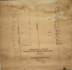
Plan - Napoleon, Nell Gwynne Transverse Section, 14.1.1946
... Map drawn on heavy paper. Printed on bottom of plan" Transverse Section Napoleon and Nell Gwynne Lines of Reef' and 'J.J. ...mine Managers plans, illustrate the extent of previous underground operations and indicate points at which future prospecting may be advantageously continued. The no.10 (920 ft) south level connects with the main Napoleon shaft no.5 level (479 ft) appears to present the best opportunity for testing the prospects that are believed to have been inadequately investigated by the Bendigo Mines Limited in recent years. gold mining Bendigo Napoleon Gold Mine Nell Gwynne Reef lines J.J. ...Napoleon Lease no.11111 is situated immediately south from the Golden Square railway station. It embraces an approx length of 36 chains of the Napoleon Anticline. The old Napoleon shaft, the depth of which is 1020 ft, occupies a central position in the area of about 43 acres. The accompanying sections, which are prepared from mine Managers plans, illustrate the extent of previous underground operations and indicate points at which future prospecting may be advantageously continued. The no.10 (920 ft) south level connects with the main Napoleon shaft no.5 level (479 ft) appears to present the best opportunity for testing the prospects that are believed to have been inadequately investigated by the Bendigo Mines Limited in recent years.Map drawn on heavy paper. Printed on bottom of plan" Transverse Section Napoleon and Nell Gwynne Lines of Reef' and 'J.J. Caldwell, District Field Geologist, Mines Department, Bendigo. 14.1.46'. Napoleon anticline and Central Nell Gwynne anticline marked on map. Map is part of the Margaret Roberts Collection of mining documents. gold mining, bendigo, napoleon gold mine, nell gwynne, reef lines, j.j. caldwell, 1946 -
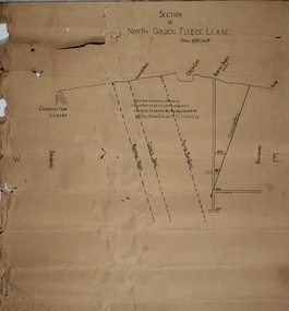 Bendigo Historical Society Inc.
Plan - North Golden Fleece Lease, unknown
... North Golden Fleece Gold Mine gold mining Bendigo lease holding Albert Gold Mine Ramrod Reef Comet Reef Stafford Reef and Frying Pan Reef Map drawn on heavy paper, titled 'Section of North Golden Fleece lease'. ...Map drawn on heavy paper, titled 'Section of North Golden Fleece lease'. Scale 80 ft to 1 inch. Written on plan in black print: 'This belt of country contains large bodies of auriferous quartz and at present is being operated on by the New Golden Fleece Company'. Reef lines marked on plan: Ramrod Reef, Comet Reef, Stafford Reef and Frying Pan Reef. The water race, Albert shaft and open cut are marked at the surface level. This plan is part of the Margaret Roberts Collection. north golden fleece gold mine, gold mining, bendigo, lease holding, albert gold mine, ramrod reef, comet reef, stafford reef and frying pan reef