Showing 2910 items matching " map of victoria"
-
 Wodonga & District Historical Society Inc
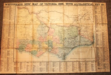
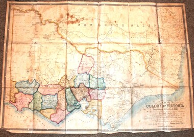
Map - Whiteheads New Map of Victoria, E. Whitehead & Co., engravers & lithographers, 1868
... Whiteheads New Map of Victoria ...Whiteheads New Map of Victoria ...His series of maps of Victoria became one of the most successful and most profitable series of regional maps of Australia ever produced....A detailed early map of Victoria with counties clearly marked and shaded and a detailed index. ...Whiteheads New Map of Victoria Map Whiteheads New Map of Victoria E. ...Edward Whitehead was a printer and publisher active in Melbourne during the latter half of the 19th century. Whitehead founded his printing business at 67 Collins Street East in 1864 and, though not focused on maps, began publishing his own series of maps of Victoria in 1867. He focussed on producing highly detailed folding maps of Victoria which included a very detailed index of place names. His series of maps of Victoria became one of the most successful and most profitable series of regional maps of Australia ever produced.This is a very early map of Victoria showing Belvoir (Wodonga)A detailed early map of Victoria with counties clearly marked and shaded and a detailed index. It also shows roads, post office towns, railways, telegraphs, gold mining areas and notes on topography. Relief shown by hachures and spot heights. Includes a list of towns with distances from Melbourne on 3 sides of map. It is produced on paper mounted on linen.victoria cartography, rare maps victoria, whiteheads maps -
 Kew Historical Society Inc
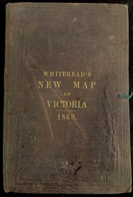
Map, Whitehead's Map of Victoria, With Alphabetical Key, 1869, 1869
... Whitehead's Map of Victoria, With Alphabetical Key, 1869...e whitehead's new map of victoria 1869...The following year, 1870, Whitehead's promoted the edition in the Portland Guardian and Normanby General Advertiser (3 January 1870), advising that: "WHITEHEAD'S NEW MAP OF VICTORIA, 1869 ... is corrected to the latest date, and around is arranged an Alphabetical Key, with Post Towns and Money Order Olffices marked. ...Map of Victoria with gold mining areas, notes on topography, transport routes. ...Cover "WHITEHEAD'S NEW MAP OF VICTORIA 1869"...In addition to its historical significance, this is a rare map, of which the only known copies in Australian public collections are those held at the National Library of Australia, the State Library of Victoria, State Library of New South Wales and the University of Queensland Library. maps - victoria - 1860s e whitehead's new map of victoria 1869 whitehead's map of victoria with alphabetical key 1869 cartography gold rush Cover "WHITEHEAD'S NEW MAP OF VICTORIA 1869" Map of Victoria with gold mining areas, notes on topography, transport routes. ...When E. Whitehead's New Map of Victoria was released in 1869, an advertisement in the Bendigo Advertiser (16 July 1869) noted that: "This beautifully engraved Map has been revised and brought down to the present time; and, with the Alphabetical Key, is the most complete and the cheapest Map ever published; Price, 6d plain; 1s colored; 2s 6d in case; on linen, post free, 2d extra. E.. WHITEHEAD and CO, Publishers, 67 Collins-street east." The following year, 1870, Whitehead's promoted the edition in the Portland Guardian and Normanby General Advertiser (3 January 1870), advising that: "WHITEHEAD'S NEW MAP OF VICTORIA, 1869 ... is corrected to the latest date, and around is arranged an Alphabetical Key, with Post Towns and Money Order Olffices marked. The Map being divided into squares and numbered, by reference to the Key any place can be found immediately. Price Is beautifully colored, or mounted on linen in case, 2s 6d. Post free, 2d extra, in Victoria. B. Whitehead and C0., Puolishers, 67 Collins-street East, Melbourne". In the same edition of the Portland Advertiser, they also promoted their business generally, saying: "E WHITEHEAD and Co., Stationers, Engravers, Lithographers, 67 Collins street East, execute every description of Lithographic PRINTING, BILL-HEADS. NOTE Headings. Business Dies Engraved and Embossed on Envelopes &c. ARMS, MONOGRAMS, AND CRESTS Engraved and Embossed in Colour, superior to any other house in the Colony. Specimens, post free, 2d. Lithographers, &c, to H.R.H. the Duke of Edinburgh, and Die-inkers and Embossers to His Excellency Sir J. H. T. Manners-Sutton, K C.B. Orders executed for the Trade". Whitehead’s New Map of Victoria 1869 is is an important record of region created towards the end of the Victorian Gold Rush (1851-1869). In addition to its historical significance, this is a rare map, of which the only known copies in Australian public collections are those held at the National Library of Australia, the State Library of Victoria, State Library of New South Wales and the University of Queensland Library.Map of Victoria with gold mining areas, notes on topography, transport routes. Relief shown by hachures. List of towns with distance from Melbourne in map margin. [Melbourne] : Printed & Published by ... E Whitehead & Co ... 67 Collins Street East, 1869 1 map : col., mounted on linen ; 38.4 x 55.4 cm, folded to 18 x 12 cm.Cover "WHITEHEAD'S NEW MAP OF VICTORIA 1869"maps - victoria - 1860s, e whitehead's new map of victoria 1869, whitehead's map of victoria with alphabetical key 1869, cartography, gold rush -
 Emerald Museum & Nobelius Heritage Park
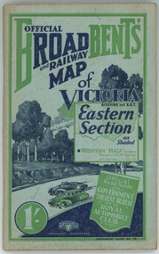
Book - Broadbent's Official Road and Railway map of Victoria, Broadbent's Official Road and Railway map of Victoria Riverina and A.C.T. Eastern Section
... Broadbent's Official Road and Railway map of Victoria... Broadbent's Official Road and Railway map of Victoria Riverina and A.C.T. Eastern Section...Broadbent's Official Road and Railway map of Victoria Riverina and A.C.T. Eastern Section Book Broadbent's Official Road and Railway map of Victoria ...The book compiles a guide on how to travel across Victoria including sights to see and places to stay.Green colouring. Old browning paper.non-fictionThe book compiles a guide on how to travel across Victoria including sights to see and places to stay. -
 Bendigo Historical Society Inc.
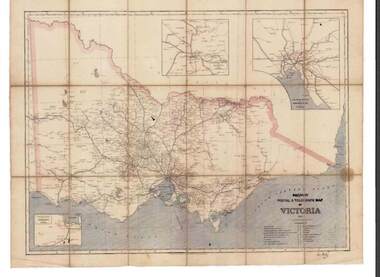
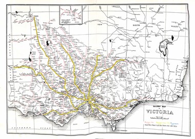
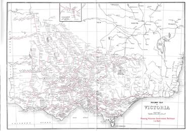
Map - RAILWAYS COLLECTION: PHOTO OF RAILWAY POSTAL & TELEGRAPH MAP OF VICTORIA 1887, 1887
... RAILWAYS COLLECTION: PHOTO OF RAILWAY POSTAL & TELEGRAPH MAP OF VICTORIA 1887...Railway Postal & Telegraph Map of Victoria 1887-...RAILWAYS COLLECTION- photo of Railway Postal & Telegraph Map of Victoria 1887- aged map showing the various Country Lines and insets show Melbourne and vicinity, Ballarat and vicinity and Geelong and vicinity....Map RAILWAYS COLLECTION: PHOTO OF RAILWAY POSTAL & TELEGRAPH MAP OF VICTORIA 1887 ...RAILWAYS COLLECTION- photo of Railway Postal & Telegraph Map of Victoria 1887- aged map showing the various Country Lines and insets show Melbourne and vicinity, Ballarat and vicinity and Geelong and vicinity.Picturesque Atlas Publishing Companyphotograph, railway postal & telegraph map of victoria 1887- -
 Sunshine and District Historical Society Incorporated
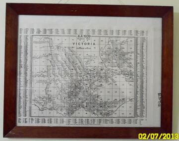
Map - Railway Map Of Victoria 1939
... Railway Map Of Victoria 1939...Map in frame showing the RAILWAY LINES of VICTORIA plus PASSENGER MILEAGES as of 4.4.1939. ...Railway Map of Victoria...Railway Railway Map of Victoria Map in frame showing the RAILWAY LINES of VICTORIA plus PASSENGER MILEAGES as of 4.4.1939. ...Historical record of the railway line system in the state of Victoria in 1939.Many of the railway lines no longer exist.Railway Map of Victoriarailway -
 Bendigo Historical Society Inc.
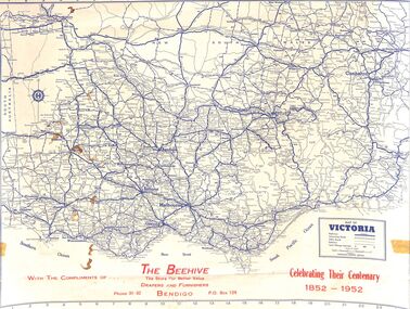
Map - Edith Perry Collection: Map of Victoria, produced by The Beehive celebrating their centenary 1852 - 1952 for patrons, 1952
... Edith Perry Collection: Map of Victoria, produced by The Beehive celebrating their centenary 1852 - 1952 for patrons...Map of Victoria...Edith Perry Collection: A3 Map of Victoria printed in blue and red ink. The map was produced for The Beehive department store (referenced as Drapers and Furnishers) in celebration of their Centenary 1852 - 1952. ...Map of Victoria Victorian towns and roads Map Edith Perry Collection: A3 Map of Victoria printed in blue and red ink. ...Map of VictoriaEdith Perry Collection: A3 Map of Victoria printed in blue and red ink. The map was produced for The Beehive department store (referenced as Drapers and Furnishers) in celebration of their Centenary 1852 - 1952. The map was provided to customers with "compliments of the Beehive". The rear of the map has a full index of Victorian towns and a Victorian Mileage table. The map was produced by R.M. Harrison Pty. Ltd., Printers and Map Publishers, 422 Collins Street, Melbouirnew, Victoria.victorian towns and roads, map -
 Parks Victoria - Mount Buffalo Chalet
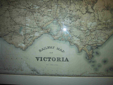
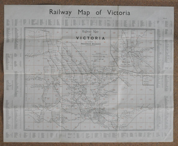
Map, "Railway Map of Victoria"
... "Railway Map of Victoria"...Large framed map of Victoria, showing Victorias extensive rail network. ...Large railway map of Victoria, Melbourne & Ballarat framed in white painted wood. ...Areas of the map have been whited out. "Railway Map of Victoria" Map ...Large framed map of Victoria, showing Victorias extensive rail network. Printed by Victorian Railways and is one of a number of 'framed pictures, particularly photographs of scenery, which have always been a feature of the Chalet.' (Pg 83. Historica, 2011) This map has been a permanent fixture situated in the hallway alongside the ballroom leading to the ski hire area since the 1950's and most likely earlier. Listed in Draft Inventory of Significant Collection ItemsLarge railway map of Victoria, Melbourne & Ballarat framed in white painted wood. Scale eight miles to one inch. Areas of the map have been whited out.Yes -
 Yarrawonga and Mulwala Pioneer Museum
Map, Map of Victoria, 1868
... Map of Victoria...1868 Map of Victoria...Yarrawonga and Mulwala Pioneer Museum 151 Melbourne St, Mulwala Original property of Alice Rebecca Puckey [nee Ford] Born England 23/07/1867 Died rosbud Vic 16/03/1951 Grandmother of Merven Elizabeth Clarke 30 Sturt st Mulwala 1868 Map of Victoria Map of Victoria Map ...Original property of Alice Rebecca Puckey [nee Ford] Born England 23/07/1867 Died rosbud Vic 16/03/1951 Grandmother of Merven Elizabeth Clarke 30 Sturt st Mulwala1868 Map of Victoria -
 Ballarat Heritage Services
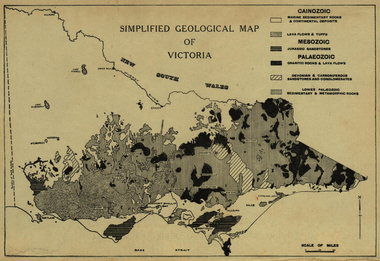
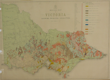
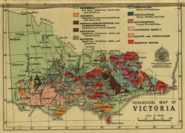
Map, Simplified Geological Map of Victoria, c1940, c1940
... Simplified Geological Map of Victoria, c1940...victoria...map...Physiographic map of Victoria....Ballarat Heritage Services PO Box 2209 Bakery Hill Post Office goldfields victoria map geology geological Physiographic map of Victoria. ...Physiographic map of Victoria.victoria, map, geology, geological -
 Sunshine and District Historical Society Incorporated
Map - Railway Map of Victoria, Yarra Valley Railways Healesville
... Railway Map of Victoria...Railway Map of Victoria Railways in 1946, Passenger Lines in 1990 and Preservation Lines...Railway Railway Map of Victoria Railways in 1946, Passenger Lines in 1990 and Preservation Lines Map of Victoira showing Railways in 1946, Passenger Lines in 1990 and Preservation Lines Map Railway Map of Victoria Yarra Valley Railways Healesville ...Railway Map of Victoria Railways in 1946, Passenger Lines in 1990 and Preservation Linesrailway -
 Federation University Historical Collection
Map, Department of Mines - Victoria, Geological Map of Victoria, 1936, 1936
... Geological Map of Victoria, 1936...victoria...geology...map...Printed colour geological map of Victoria....Geological Map of Victoria, 1936 Map Department of Mines - Victoria ...Printed colour geological map of Victoria.victoria, geology, map, geological map -
Stawell Historical Society Inc
Map, Whitehead's Map of Victoria, with Alphabetical Key, 1869
... Whitehead's Map of Victoria, with Alphabetical Key...Whitehead's Map of Victoria, with Alphabetical Key...Stawell Historical Society Inc 46 Longfield St Stawell grampians Stawell Whitehead's Map of Victoria, with Alphabetical Key Whitehead's Map of Victoria, with Alphabetical Key Map ...Whitehead's Map of Victoria, with Alphabetical Keystawell -
Stawell Historical Society Inc
Map, Land Map of Victoria 1898, Supplement to "The Leader", 1898
... Land Map of Victoria 1898, Supplement to "The Leader"...Land Map of Victoria 1898, Supplement to "The Leader"...Stawell Historical Society Inc 46 Longfield St Stawell grampians Stawell Land Map of Victoria 1898, Supplement to "The Leader" Land Map of Victoria 1898, Supplement to "The Leader" Map ...Land Map of Victoria 1898, Supplement to "The Leader"stawell -
 Bendigo Historical Society Inc.
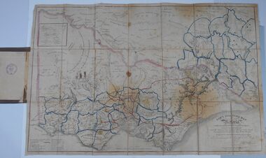
Document - HARRIS COLLECTION: HAMS SQUATTING MAP OF VICTORIA, PORT PHILLIP DISTRICT, NSW
... HARRIS COLLECTION: HAMS SQUATTING MAP OF VICTORIA, PORT PHILLIP DISTRICT, NSW...MAP...Victoria...(State Library Victoria https://www.slv.vic.gov.au/squatting-map-victoria)...Map backed by cloth and bound. Rare, early map of Victoria and neighbouring Port Phillip District of New South Wales. ...(State Library Victoria https://www.slv.vic.gov.au/squatting-map-victoria) MAP Victoria squatting map Folding map enclosed in burgundy cover. ...Thomas Ham was a cartographer, engraver, lithographer and publisher in Victoria and Queensland. He compiled and printed several editions of his squatting map, beginning with A map of Australia Felix in 1847 and changing its title to Ham's squatting map of Victoria in 1851. The 1851 edition was accompanied by a key listing the names of all the squatters within squatting districts and counties. Later editions show the existing counties, but some areas of Gippsland and the Australian Alps are still described as 'unsurveyed country'. (State Library Victoria https://www.slv.vic.gov.au/squatting-map-victoria)Folding map enclosed in burgundy cover. Map backed by cloth and bound. Rare, early map of Victoria and neighbouring Port Phillip District of New South Wales. Written on bottom RH corner of map: Ham's Squatting Map of Victoria ( Port Phillip District, New South Wales ) carefully corrected to this date from the Colonial Government Surveys, Crown Lands, Commissioners & Explorers Maps, Private Surveys & c. Respectfully inscribed (with permission ) to His Excellency Sir Chas A. Fitz-Roy Knt, Governor of New South Wales &c &c by his Obedient Servant, The Compiler, 1851. Compiled, engraved and published by Thomas Ham, Melbourne. Proposed and original boundary ( in legend) have been coloured in in blue and pink ink ( later addition ?) Number on map show 'reference to proprietor's Printed on back of map ' J.G. AD 1852, with two cross hatched decorations and two hearts entwined. On other back panel in pencil enclosed in a drawn frame ' G.S.H., 1889, Axedale' (George Harris, Axedale, belongs in Harris Collection) Stamped in purple ink 'Royal Historical Society of Victoria, Bendigo Branch. Written 1959, 53.map, victoria, squatting map -
 Bendigo Historical Society Inc.
Map - RAILWAYS COLLECTION: 1946 RAILWAY MAP OF VICTORIA AUSTRALIA, 1946
... RAILWAYS COLLECTION: 1946 RAILWAY MAP OF VICTORIA AUSTRALIA...MAP...Victoria...Railways Collection-1946 glossy paper Railway Map of Victoria Australia Reproduced courtesy of V/Line by the Railway Museum North Williamstown Victoria 1988 price 3 pence. ...Map RAILWAYS COLLECTION: 1946 RAILWAY MAP OF VICTORIA AUSTRALIA ...Railways Collection-1946 glossy paper Railway Map of Victoria Australia Reproduced courtesy of V/Line by the Railway Museum North Williamstown Victoria 1988 price 3 pence. The maps shown are Railway Map of Suburban Lines Melbourne and Railways map of Victoria Showing Victorian Government Railways in red.map, victoria -
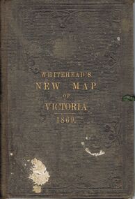 Bendigo Historical Society Inc.
Book - WHITEHEAD'S NEW MAP OF VICTORIA 1869, 1869
... WHITEHEAD'S NEW MAP OF VICTORIA 1869...VICTORIA...History...map...A brown/grey embossed book, with gold lettering titled 'Whitehead's New Map of Victoria 1869' containing a cloth bound map of Victoria, with coloured regions, with an alphabetical key of towns. ...In pencil inside book is marked 'W C' Book WHITEHEAD'S NEW MAP OF VICTORIA 1869 ...A brown/grey embossed book, with gold lettering titled 'Whitehead's New Map of Victoria 1869' containing a cloth bound map of Victoria, with coloured regions, with an alphabetical key of towns. Markings - ?(possibly J C) Bailey written on reverse of map in pen. In pencil inside book is marked 'W C'victoria, history, map -
 Bendigo Historical Society Inc.
Map - RAILWAY POSTAL & TELEGRAPH MAP OF VICTORIA, 1887
... RAILWAY POSTAL & TELEGRAPH MAP OF VICTORIA...MAP...Victoria...Railway Postal & Telegraph Map of Victoria 1887 printed on canvas in a fold out book form with name printed on back F.L.Outtrim, in a cardboard cover with red and blue pattern....Map RAILWAY POSTAL & TELEGRAPH MAP OF VICTORIA ...Railway Postal & Telegraph Map of Victoria 1887 printed on canvas in a fold out book form with name printed on back F.L.Outtrim, in a cardboard cover with red and blue pattern.Picturesque Atlas Publishing Co Ltd Sydney & Melbournemap, victoria, railway -
 Federation University Historical Collection
Photograph - colour, William Baragwanath, Department of Mines: Geological map of Victoria, c1935
... Department of Mines: Geological map of Victoria...map...department of mines...victoria...Barker Library (top floor) Mount Helen goldfields Photograph included in book "Victoria: Gold and Minerals" issued by Mines Department Victoria, 1935 map department of mines victoria key to land formations time periods jurassic geological map Photograph Department of Mines: Geological map of Victoria Photograph - colour William Baragwanath Victorian Mines Department ...Photograph included in book "Victoria: Gold and Minerals" issued by Mines Department Victoria, 1935Photographmap, department of mines, victoria, key to land formations, time periods, jurassic, geological map -
 Whitehorse Historical Society Inc.
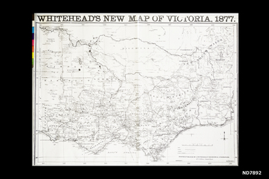
Map, Whitehead's New map of Victoria, 1877
... Whitehead's New map of Victoria...Map...Victoria...Map of Victoria 1877 Scale 8.5 cm : 80 miles...Whitehorse Historical Society Inc. 2-10 Deep Creek Road Mitcham melbourne Map of Victoria 1877 Scale 8.5 cm : 80 miles Map Victoria A map of Victoria produced in 1877 Whitehead's New map of Victoria Map E. ...A map of Victoria produced in 1877non-fictionA map of Victoria produced in 1877map, victoria -
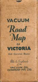 Sunshine and District Historical Society Incorporated
Map - Joseph 'Joe' Wlodarczyk Collection - Vacuum Road Map Of Victoria
... Joseph 'Joe' Wlodarczyk Collection - Vacuum Road Map Of Victoria...This map also identified the location of Vacuum Oil Company Dealerships throughout Victoria. ...Envelope - Pidd's Garage Melbourne Road Newport Local Dealer Olympic Tyres Vacuum Road Map of Victoria with Interstate Routes with the compliments of the Vacuum Oil Company Pty Ltd. ...Map - Vacuum Road Guide of Victoria Visit Melbourne Centenary 1934-5 Vacuum Oil Company Pty Ltd Fold out paper map in an envelope Map Joseph 'Joe' Wlodarczyk Collection - Vacuum Road Map Of Victoria ...Road travelers relied on foldable paper maps to chart their journeys, especially when venturing beyond familiar territory. Maps helped identify highways, towns, and landmarks, enabling drivers to choose efficient or scenic routes. These maps were indispensable tools for travel, planning, and exploration. This map also identified the location of Vacuum Oil Company Dealerships throughout Victoria. These paper-based maps were used before Global Positioning System "GPS" revolutionized navigation. - Envelope - Pidd's Garage Melbourne Road Newport Local Dealer Olympic Tyres Vacuum Road Map of Victoria with Interstate Routes with the compliments of the Vacuum Oil Company Pty Ltd. Map - Vacuum Road Guide of Victoria Visit Melbourne Centenary 1934-5 Vacuum Oil Company Pty Ltdmap, vacuum oil company, pidd's garage, melbourne road, newport, joseph 'joe' wlodarczyk -
Whitehorse Historical Society Inc.
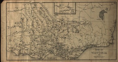
Map, Railway map of Victoria, 1912
... Railway map of Victoria...Detailed map of railways in Victoria including adjacent areas of New South Wales. ...Detailed map of railways in Victoria including adjacent areas of New South Wales. ...Detailed map of railways in Victoria including adjacent areas of New South Wales.Detailed map of railways in Victoria including adjacent areas of New South Wales. Also shows 'principal coach routes'. On verso map of suburban lines with eastern line as far as Croydon and Bayswater. key numbers on map linked to pages of a timetable.Detailed map of railways in Victoria including adjacent areas of New South Wales.maps, railways -
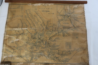 Kiewa Valley Historical Society
Map - Railway Map of Victoria, Amended to 1/11/1945
... Map - Railway Map of Victoria...Plastic on parchment with detailed railway routes (in green) across Victoria including each district's 'Road Foremen' and 'Depots'. There is a length of flat wood attached by 10 tacks across the top of the map...Victorian railways 1945 trains transport Plastic on parchment with detailed railway routes (in green) across Victoria including each district's 'Road Foremen' and 'Depots'. There is a length of flat wood attached by 10 tacks across the top of the map Amended to 1/11/1945 Map - Railway Map of Victoria ...Railways began in the 1850s and were privately owned and operated. Later they were taken over by the Victorian Government reaching a peak in the early 1940s.Steam trains were followed by electric trains with both running after the war in 1945.Bright was the closest station to the Kiewa Valley but road transport was used more often as the Kiewa Valley Highway was improved with the construction of the Kiewa Hydro Electric Scheme. To travel to Melbourne or Sydney by train residents went via Wodonga/Albury where they also did their shopping.Plastic on parchment with detailed railway routes (in green) across Victoria including each district's 'Road Foremen' and 'Depots'. There is a length of flat wood attached by 10 tacks across the top of the mapvictorian railways 1945, trains, transport -
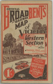 Emerald Museum & Nobelius Heritage Park
Book - Broadbent's Official Road and Railway Map of Victoria Western Section
... Broadbent's Official Road and Railway Map of Victoria Western Section...Book Broadbent's Official Road and Railway Map of Victoria Western Section ...The book was published in the 1930s - 1940s by the Broadbent's Official Road Guides Co. The book compiles a guide of how to travel across Victoria's western section and lists places to see and stay as a tourist.The item has significance as it gives insight into how tourists travelled in the early to mid 1900s across Victoria.Paperback book, paper browning. Red and black colouring on front and back. -
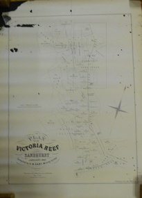 Bendigo Historical Society Inc.
Document - MARKS COLLECTION: MAP OF VICTORIA REEF MINING CLAIMS
... MARKS COLLECTION: MAP OF VICTORIA REEF MINING CLAIMS...Copy of map. On bottom LH side: Plan of the Victoria Reef Sandhurst January 1867, Compiled by G.W. ...Document MARKS COLLECTION: MAP OF VICTORIA REEF MINING CLAIMS ...Copy of map. On bottom LH side: Plan of the Victoria Reef Sandhurst January 1867, Compiled by G.W. Hart, Mining Surveyor. Published by John N. Macartney, Argus Agent, Sandhurst. Price 4/- each. On bottom Rh side J.W. Pearson & Co. Lith. Melbourne Plan shows mining claims and names of holders, scale (4 chains to one inch) Loddon Road, Mount Korong Road, Ironbark Gully, township of Long Gully, Quartz Miners' Arms and Gold Mines Hotel on Loddon Road.bendigo, mining, victoria reef plan -
 Wodonga & District Historical Society Inc
Map - Tulloch & Brown's Map of the Colony of Victoria, Tulloch & Brown, 1856
... Tulloch & Brown's Map of the Colony of Victoria...Tulloch & Brown's Map of the Colony of Victoria...map was created by Tulloch and Brown. David Tulloch was one of the earliest engravers and lithographers in the state of Victoria. ...A foldable map mounted on linen and with a board cover. It records the Colony of Victoria according to Surveyor's Records revised in 1857. ...At bottom right hand section of map: Tulloch & Brown's map of the Colony of Victoria : comprising part of New South Wales, the boundaries, counties, also seaport & inland townships, the gold fields with the latest discoveries, roads, tracks, &c. ...Tulloch & Brown's Map of the Colony of Victoria Map Tulloch & Brown's Map of the Colony of Victoria Tulloch & Brown ...The map was created by Tulloch and Brown. David Tulloch was one of the earliest engravers and lithographers in the state of Victoria. He arrived in Melbourne from Greenock, Scotland, on 3 January 1849. Following the discovery of gold Tulloch went to the Victorian goldfields in 1851, commissioned to make sketches of the diggers and the diggings for Ham’s Illustrated Australian Magazine. In November 1852 Tulloch set up in business as engraver, draughtsman, copperplate printer and lithographer. Tulloch took a map engraver, James Davie Brown, into partnership in March 1853; the several maps and specimens of commercial engraving they showed at the 1854 Melbourne Exhibition were awarded a bronze medal. That year Tulloch and Brown also received a silver medal at the Victorian Industrial Exhibition. The partnership was dissolved towards the end of 1856.This is a very early map of the Colony of Victoria including Belvoir (now know as Wodonga).A foldable map mounted on linen and with a board cover. It records the Colony of Victoria according to Surveyor's Records revised in 1857. Areas of the map are shaded to highlight different counties.At bottom right hand section of map: Tulloch & Brown's map of the Colony of Victoria : comprising part of New South Wales, the boundaries, counties, also seaport & inland townships, the gold fields with the latest discoveries, roads, tracks, &c. &c. / compiled from drawings in the Survey Office and correctly revised till 1857. Respectfully dedicated by Permission, to the Honorable Captain Andrew Clarke R.E. Surveyor General of Victoria by His Obediant Servants Tulloch & Brown, Engravers & Publishers, Melbourne". At bottom right below border : Published as the Act directs by the Proprietors, Melbourne, 1st Feb. 1856. tulloch and brown maps, rare maps victoria, victorian cartography -
 Orbost & District Historical Society
map, Railway Map of Victoria, 1.8.1965
... Railway Map of Victoria...A large rectangular shaped paper map of all railway stations in Victoria. It is dated 1st August 1965. ...A key is provided and each station has a grid reference. Railway Map of Victoria map Victorian Government Railways ...The Bairnsdale-Orbost railway was opened in 1916 to serve the agricultural and timber industry. Because of the decline in traffic and heavy operating costs, the line was finally closed in August, 1987.This item is associated with the history of the Orbost-Bairnsdale railway line and therefore reflects the role that the rail line played in the social and economic history of Orbost.A large rectangular shaped paper map of all railway stations in Victoria. It is dated 1st August 1965. It is divided into grids. Stations are listed around the map. A key is provided and each station has a grid reference.map-railway victorian-railways -
Phillip Island and District Historical Society Inc.
Book, F.E. Hiscocks &? Co, F.E. Hiscocks &? Co.'s new Victorian counties atlas, 1874 [cartographic material] : together with map of Victoria, indicating roads, distances, relative position of counties, &?c, 1874
... s new Victorian counties atlas, 1874 [cartographic material] : together with map of Victoria, indicating roads, distances, relative position of counties, &?...s new Victorian counties atlas, 1874 [cartographic material] : together with map of Victoria, indicating roads, distances, relative position of counties, &? ...Labelled 'Cowes Free Public Library', 'Phillip Island Historical Society, Cleeland Bequest'.victoria, maps -
Phillip Island and District Historical Society Inc.
Book, Whitehead, Whitehead's new map of Victoria with alphabetical key 1867-8, 1868
... Whitehead's new map of Victoria with alphabetical key 1867-8...Phillip Island and District Historical Society Inc. phillip-island-and-the-bass-coast Whitehead's new map of Victoria with alphabetical key 1867-8 Book Whitehead ... -
Glenelg Shire Council Cultural Collection
Map, Railway Map of Victoria, n.d
... Railway Map of Victoria...Railway map, paper on fabric backing, wooden support top and bottom edges, eye screws and hanging wire in top support. Railway Map of Victoria Map Map ...Port of Portland CollectionFront: verso - 'Way and Works branch railway Department Melbourne Dec 1954.'port of portland archives, railway, map, 1954, 1950s -
 Federation University Historical Collection
Map, Railway Map of Victoria, 1930
... Railway Map of Victoria...map...railway...train-lines...victoria...Cardboard map of Victorian railway system in 1930. Maps out all train-lines in Victoria and into New South Wales. ...Railway Map of Victoria Map ...Cardboard map of Victorian railway system in 1930. Maps out all train-lines in Victoria and into New South Wales. map, railway, train-lines, victoria, victorian railways, railway lines