Showing 2089 items matching " maps and plans"
-
 Whitehorse Historical Society Inc.
Document, Historical maps and plans, 1855 1889
... Historical maps and plans...Copy of catalogue of historical maps and plans - Crown Lands Department...Whitehorse Historical Society Inc. 2-10 Deep Creek Road Mitcham melbourne Maps Historical maps Copy of catalogue of historical maps and plans - Crown Lands Department Copy of catalogue of historical maps and plans - Crown Lands Department Historical maps and plans Document Document ...Copy of catalogue of historical maps and plans - Crown Lands DepartmentCopy of catalogue of historical maps and plans - Crown Lands DepartmentCopy of catalogue of historical maps and plans - Crown Lands Departmentmaps, historical maps -
 Bacchus Marsh & District Historical Society
Map, Bacchus Marsh Region Parish Plans: Folded set of maps
... Bacchus Marsh Region Parish Plans: Folded set of maps...BMDHS Location: AR/SU27/D2: Map Drawers...BMDHS Location: AR/SU27/D2: Map Drawers Bacchus Marsh Region Parish Plans: Folded set of maps Map ...Set of Victorian Lands Department Parish Plans covering the township of Bacchus Marsh and surrounding districts. Folded. BMDHS Location: AR/SU27/D2: Map Drawersmaps bacchus marsh region, bacchus marsh victoria maps -
Kew Historical Society Inc
Archive (series) - Subject File, Maps and plans, 1838-1998
... Maps and plans...Kew Historical Society Inc Kew Court House 188 High Street Kew melbourne Maps and plans Archive Subject File ...Reference, Research, InformationSecondary Values (KHS Imposed Order)Subject file containing a range of maps from different historical periods. Some have newspaper articles with background historical information. Some are maps produced by the MMBW, Members of Parliament, Melways, and hand-drawn maps locating where buildings, people and places were formerly in evidence. -
 Sunshine and District Historical Society Incorporated
Map - Sunshine Planning Scheme Maps
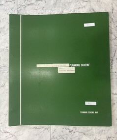
... Sunshine Planning Scheme Maps...Sunshine Planning Scheme Maps Working Copy & Exhibition Amendments...City of Sunshine Sunshine Planning Scheme Maps Working Copy & Exhibition Amendments Sunshine Planning Scheme Maps Map Sunshine Planning Scheme Maps ...Sunshine Planning Scheme Maps Working Copy & Exhibition Amendmentscity of sunshine -
 Sunshine and District Historical Society Incorporated
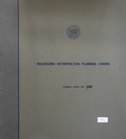
Map - Melbourne Metropolitan Planning Scheme 1968 Map, Melbourne and Metropolitan Board of Works, 1968
... Collection of Melbourne Metropolitan Planning Scheme 1968 Map mounted in a grey folder...Melbourne Metropolitan Planning Scheme 1968 Map...City of Sunshine Melbourne Metropolitan Planning Scheme 1968 Map Collection of Melbourne Metropolitan Planning Scheme 1968 Map mounted in a grey folder Map Melbourne Metropolitan Planning Scheme 1968 Map Melbourne and Metropolitan Board of Works ...Melbourne Metropolitan Planning Scheme 1968 Mapcity of sunshine -
 Sunshine and District Historical Society Incorporated
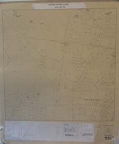
Map - Sunshine Planning Scheme Map 1988, 16/02/1988 12:00:00 AM
... Very light coloured map that shows the planning scheme of the local section of Sunshine....Sunshine Planning Scheme Local Section|Index to Adjoining Imperial Series Maps|Melbourne Metropolitan Planning Scheme Imperial Series|Map No. 26 B Gazetted|Note:- The Planning Information Shown on this Map Applies only to the Area Affected by this Planning Scheme....Map Sunshine Planning Scheme Map 1988 ...Sunshine Planning Scheme Local Section|Index to Adjoining Imperial Series Maps|Melbourne Metropolitan Planning Scheme Imperial Series|Map No. 26 B Gazetted|Note:- The Planning Information Shown on this Map Applies only to the Area Affected by this Planning Scheme.|Approved, Tom Roper, Minister for Planning and Environment, 16 February 1988sunshine -
 Sunshine and District Historical Society Incorporated
Map - Sunshine Planning Scheme Maps
... Collection of Sunshine Planning Scheme Maps Working Copy & Exhibition Amendments mounted in a green folder...Sunshine Planning Scheme Maps Working Copy & Exhibition Amendments...City of Sunshine Sunshine Planning Scheme Maps Working Copy & Exhibition Amendments Collection of Sunshine Planning Scheme Maps Working Copy & Exhibition Amendments mounted in a green folder Map Sunshine Planning Scheme Maps ...Sunshine Planning Scheme Maps Working Copy & Exhibition Amendmentscity of sunshine -
 Yarra Ranges Regional Museum
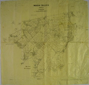
Map, H J Green, Acting Govt. Printer, Wandin Yallock, County of Evelyn (Parish Plan), c. 1910 - 1920
... Parish Plan of Wandin Yallock. Location of Silvan Reservoir marked in ink on map....Parish Plan of Wandin Yallock. Location of Silvan Reservoir marked in ink on map. ...Wandin Yallock Maps Parish Plan of Wandin Yallock. Location of Silvan Reservoir marked in ink on map. ...Parish Plan of Wandin Yallock. Location of Silvan Reservoir marked in ink on map.Parish Plan of Wandin Yallock. Location of Silvan Reservoir marked in ink on map. wandin yallock, maps -
 Bacchus Marsh & District Historical Society
Map, Plan of Survey of Part of Crown Allotment 9, Parish of Korkuperrimul, 1890
... Scale 100 feet to inch. Part of a set of maps which are pasted into a bound volume containing 76 maps or plans in total. ...At bottom of map: I hereby certify that I have made this survey expressly for the purpose of an application under the Transfer of Land Statute that this plan is correct. ...Scale 100 feet to inch. Part of a set of maps which are pasted into a bound volume containing 76 maps or plans in total. ...This map documents a transfer of an allotment of land in Clarke Street Bacchus Marsh in 1890. Clarke Street is located on the eastern side of Bacchus Marsh not far from Main Street and Crook Street. It is now known as Candeloro Street. The map indicates J. Booth as the owner of the land and H. Simpson as the occupier. Next to this allotment is a an allotment of land owned by J. Elmore,Single page map showing Crown allotment 9, Parish of Korkuperrimul, County of Bourke. Scale 100 feet to inch. Part of a set of maps which are pasted into a bound volume containing 76 maps or plans in total. High resolution digital image stored on BMDHS computer network. At bottom of map: I hereby certify that I have made this survey expressly for the purpose of an application under the Transfer of Land Statute that this plan is correct. Barry B???, Lic. Surveyor, 16.10.90bacchus marsh victoria maps, clarke street bacchus marsh maps -
 Bendigo Historical Society Inc.
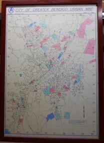
Map - City of Greater Bendigo Urban Map 1996, 19 August 1996
... This urban map of the Bendigo region is similar to other urban maps developed for Victorian municipalities during planning scheme updates in the late 20th century. ...It is the first edition and has the scale 1:12500. The map shows the urban layout, including streets, landmarks and blue or pink coloured regions, indicating planning overlays....This urban map of the Bendigo region is similar to other urban maps developed for Victorian municipalities during planning scheme updates in the late 20th century. ...This urban map of the Bendigo region is similar to other urban maps developed for Victorian municipalities during planning scheme updates in the late 20th century. Such maps were often used by local councils for urban management.A large framed colour map showing the urban area of Bendigo. The map dates to 19 August 1996. It is the first edition and has the scale 1:12500. The map shows the urban layout, including streets, landmarks and blue or pink coloured regions, indicating planning overlays.greater bendigo, map, 1996 -
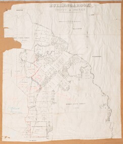 Bacchus Marsh & District Historical Society
Map, Bullengarook Parish, County of Bourke
... An undated parish plan map for the parish of Bullegarook. This parish area is close to the Bacchus Marsh district and borders some of the areas contained within the former Bacchus Marsh Shire and present day Moorabool Shire....A single page paper map showing the parish plan map for Bullengarook. ...Bullengarook Parish Maps A single page paper map showing the parish plan map for Bullengarook. ...An undated parish plan map for the parish of Bullegarook. This parish area is close to the Bacchus Marsh district and borders some of the areas contained within the former Bacchus Marsh Shire and present day Moorabool Shire.A single page paper map showing the parish plan map for Bullengarook. This parish area contains the locality of Bullengarook and parts of the Wombat State Forest and is close to the town of Gisborne. A cadastral map showing land ownership. The map is not dated but a very similar map held by the State Library of Victoria is estimated to date from about 1927. The map is pasted into a bound volume containing 76 maps or plans in total. High resolution digital image stored on BMDHS computer network. bullengarook parish maps -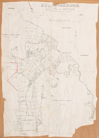
 Warrnambool RSL Sub Branch
MAP TO ACCOMPANY HEAVY ARTILLERY SCHEME FOR MOBILE WARFARE".....marked with 'Lanes' and Corps/Division Boundaries, Ordnance Survey, 1:40,000, France. Sheet 62c, Dec 1917. (centring on Peronne and Mont St Quentin), December 1917
... Inscribed "Map to accompany H.A. Scheme for Mobile Warfare". ...Inscribed "Map to accompany H.A. Scheme for Mobile Warfare". ...(Bob) Snape, Reg No 8651, enlisted as a Stretcher Bearer in 1915 but, because of his secretarial skills was employed in HQ positions as soon as he arrived in France and as a stenographer who worked as Confidential Clerk to General Sir John Monash from June to December 1918; and subsequently, for General Sir Talbot Hobbs until June 1919. The map was very likely directly used in the planning of the 1918 battles such as Mont St Quentin. ...Shows detail of Artillery Planning in the area of Peronne & Mont St Quentin. Inscribed "Map to accompany H.A. Scheme for Mobile Warfare". Marked with 'Lanes' and Corps/Division Boundaries.The donor, Staff Sergeant R.O. (Bob) Snape, Reg No 8651, enlisted as a Stretcher Bearer in 1915 but, because of his secretarial skills was employed in HQ positions as soon as he arrived in France and as a stenographer who worked as Confidential Clerk to General Sir John Monash from June to December 1918; and subsequently, for General Sir Talbot Hobbs until June 1919. The map was very likely directly used in the planning of the 1918 battles such as Mont St Quentin.Original Item recovered from possibly Australian Corps HQ, probably between the Armistice, 11 November 1918, and June 1919, when Staff Sergeant R.O.(Bob) Snape was repatriated. Shows detail of Artillery Planning in the area of Peronne & Mont St Quentin. Inscribed "Map to accompany H.A. Scheme for Mobile Warfare". Marked with 'Lanes' and Corps/Division Boundaries.snape collection -
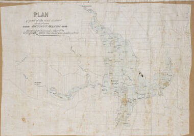 Bacchus Marsh & District Historical Society
Map, Plan of part of the road district of Bacchus Marsh circa 1856-1862
... The title of this plan being a plan of 'a portion of the road district of Bacchus Marsh' suggests that the plan was produced sometime between 1856 and 1862. ...The map is pasted into a bound volume containing 76 maps or plans in total. ...The map is pasted into a bound volume containing 76 maps or plans in total. ...Local government in much of Victoria including the Bacchus Marsh area began with the formation of 'local committees'. These local committees could make representations to a Central Road Board regarding plans for road construction. Road construction and maintenance were seen as the essential tasks of these early local government authorities. By 1856 the local committee in Bacchus Marsh was constituted as the Bacchus Marsh Road District. This entity continued until 1862 when the name changed to the Bacchus Marsh and Maddingley Road District. This new entity lasted until 1871 when the local government authority in accordance with new statewide legislation became known as the Shire of Bacchus Marsh. The title of this plan being a plan of 'a portion of the road district of Bacchus Marsh' suggests that the plan was produced sometime between 1856 and 1862. The main purpose of this map was to shown the irrigable land in the district and the sources from which water for irrigation could be drawn. Bacchus Marsh was an early irrigation district in Victoria. Irrigation trusts were formed in the 1880s and 1890s to manage irrigation districts. But this was the culmination of many years of earlier attempts to construct irrigation systems in the Bacchus Marsh area and create a system to manage irrigation more broadly. This map dating from around 1856-1862 is an important cartographic document which provides evidence of how the early planning for irrigation was developing in the Bacchus Marsh region.A single page paper map showing a plan of part of the road district of Bacchus Marsh. The map is pasted into a bound volume containing 76 maps or plans in total. High resolution digital image stored on BMDHS computer network. bacchus marsh victoria maps, bacchus marsh road district, local government, road districts, irrigation -
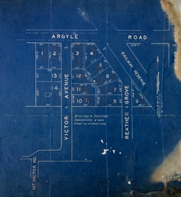 Kew Historical Society Inc
Plan - Subdivision Plan, Argyle Road, Heather Grove, Victor Avenue, Kew, c.1937
... The Kew Historical Society's map collection includes a substantial number of real estate subdivision plans, mainly of Kew but also of surrounding suburbs in Melbourne. ...[Formerly catalogued as MAP.0059]...[Formerly catalogued as MAP.0059] Argyle Road, Heather Grove, Victor Avenue, Kew Plan Subdivision Plan ...The Kew Historical Society's map collection includes a substantial number of real estate subdivision plans, mainly of Kew but also of surrounding suburbs in Melbourne. Most of the subdivision plans date from the 1920s and 1930s when the districts old homes and local farmland were being split up to accommodate residential growth in the postwar period. These early plans were assembled by a local firm, Jas R Mather & McMillan, which had an office in Cotham Road. Many of the plans, and sometimes photos, were annotated by the agents.Subdivision plans are historically important documents used as evidence for the growth of suburbs in Australia. They frequently provide information about when the land was sold as well as evidence relating to surveyors and real estate and financial agents. The numerous subdivision plans in the Kew Historical Society's collection represent working documents, ranging from the initial sketches made in planning a subdivision to printed plans on which auctioneers or agents listed the prices for which individual lots were sold. In a number of cases, the reverse of a subdivision plan in the collection includes a photograph of a house that was also for sale by the agent. These photographs provide significant heritage information relating house design and decoration, fencing and household gardens.The photograph may also be aesthetically significant depending on the importance of the photographic atelier.Undated blue subdivision plan in Kew of 14 lots facing Argyle Road, Heather Grove and Victor Road. The Plan identifies Tuxen & Miller as the surveyors. [Formerly catalogued as MAP.0059]subdivision plans - kew, argyle road - kew, heather grove - kew, victor avenue - kew -
Emerald Museum & Nobelius Heritage Park
Map - Plan of Deviation in Crown Allotments 57 & 58 Wright Rd. & McNamara Rd. 1929, Property Acquisition Settlement Advice and plan of deviation in crown allotments in Wright Rd. and McNamara Rd, C 1929 & C 1984
... Images of map and letter pertaining to land acquisition and deviation plan for crown allotments adjacent to Crown Allotments 57 & 58...Road Construction Authority/Property Acquisition - Settlement advice letter addressd to General manager of Shire of Sherbrooke, Glanfern Way Upwey/Road - Belgrave-Gembrook Rd./Survey Plan 2239/Owner Roy and Judith Ward/dated 10 September, 1984/Signed P J McCulloch, General Manager Admin/ATTACHED MAP/Plan of Deviation in Crown Allotments 57 & 58and part of the formergovernment road, Parish of Gembrook, county of Evelyn/ certified by W.P. ...Map Plan of Deviation in Crown Allotments 57 & 58 Wright Rd. & McNamara Rd. 1929 ...Images of map and letter pertaining to land acquisition and deviation plan for crown allotments adjacent to Crown Allotments 57 & 58Road Construction Authority/Property Acquisition - Settlement advice letter addressd to General manager of Shire of Sherbrooke, Glanfern Way Upwey/Road - Belgrave-Gembrook Rd./Survey Plan 2239/Owner Roy and Judith Ward/dated 10 September, 1984/Signed P J McCulloch, General Manager Admin/ATTACHED MAP/Plan of Deviation in Crown Allotments 57 & 58and part of the formergovernment road, Parish of Gembrook, county of Evelyn/ certified by W.P. BONWICH - 5.2.29 -
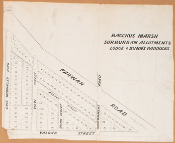 Bacchus Marsh & District Historical Society
Map, Bacchus Marsh Suburban Allotments Parwan Road Lodge & Dunn's Paddocks 1888
... This map was created as a plan for an auction of land close to the Bacchus Marsh Railway Station. ...The map is pasted into a bound volume containing 76 maps or plans in total. ...The map is pasted into a bound volume containing 76 maps or plans in total. ...This map was created as a plan for an auction of land close to the Bacchus Marsh Railway Station. The auction took place on 23 October 1888. 102 allotments of land from an area known as Lodge and Dunn's paddocks was offered for sale. A single page paper map showing allotments of land for sale along the Parwan Road in Maddingley. The map is pasted into a bound volume containing 76 maps or plans in total. High resolution digital image stored on BMDHS computer network. land sales bacchus marsh, land sales maddingley, bacchus marsh victoria maps, maddingley victoria maps -
![Map, [Coornmill land area available for leasing for grazing, Parish of Coornmill]. Circa 1904](/media/collectors/5e461d8021ea67224c82f2a1/items/677cde147f2053f3e5d277c3/item-media/677cdeea7f2053f3e5d27bb4/item-fit-380x285.jpg?cb=6) Bacchus Marsh & District Historical Society
Bacchus Marsh & District Historical SocietyMap, [Coornmill land area available for leasing for grazing, Parish of Coornmill]. Circa 1904
... This map shows an area of land north of Bacchus Marsh in the Larderderg State Park area known as the Parish of Coornmill.The map indicates an area of land which was to be made available by public tender for grazing leaseholders. ...A photo lithographed Lands Department Map. No scale indicated. The map is pasted into a bound volume containing 76 maps or plans in total. ...A photo lithographed Lands Department Map. No scale indicated. The map is pasted into a bound volume containing 76 maps or plans in total. ...This map shows an area of land north of Bacchus Marsh in the Larderderg State Park area known as the Parish of Coornmill.The map indicates an area of land which was to be made available by public tender for grazing leaseholders. The plan to do this was discussed in the Bacchus Marsh Express newspaper on the 16 July, 1904, page 2, column 7. The area reserved for grazing leases is identified by red lines on the map. The Express described the area available for grazing was 12,000 acres.A single page paper map showing an area of land in the Parish of Corrnmill to be made available for grazing leases. A photo lithographed Lands Department Map. No scale indicated. The map is pasted into a bound volume containing 76 maps or plans in total. High resolution digital image stored on BMDHS computer network. coornmill parish maps, lerderderg state park maps, agriculture bacchus marsh area -
![Map, Plan showing proposed deviation of the road through McKenzie's Flat to Bacchus Marsh. [Undated]](/media/collectors/5e461d8021ea67224c82f2a1/items/677d22f37f2053f3e5d500dc/item-media/677d25247f2053f3e5d50950/item-fit-380x285.jpg?cb=6) Bacchus Marsh & District Historical Society
Bacchus Marsh & District Historical SocietyMap, Plan showing proposed deviation of the road through McKenzie's Flat to Bacchus Marsh. [Undated]
... The date of this map or plan is uncertain. McKenzie's Flat is a bushland picnic area on the Lerderderg River in the Lerderderg State Park close to Bacchus Marsh. ...Scale: 5 chains to 1 inch. Part of a set of maps which are pasted into a bound volume containing 76 maps or plans in total. ...Scale: 5 chains to 1 inch. Part of a set of maps which are pasted into a bound volume containing 76 maps or plans in total. ...The date of this map or plan is uncertain. McKenzie's Flat is a bushland picnic area on the Lerderderg River in the Lerderderg State Park close to Bacchus Marsh. The proposed road deviation shown on this map is very close to a sharp bend in the Lerderderg River which shows an island in the centre of that bend. The name of a landholder, J.B. Perry is shown on the map close to the area of the road deviation.The land shown is identified as within the Parish of Merrimu.Single page map showing a proposed deviation of the road from McKenzie's Flat to Bacchus Marsh. Scale: 5 chains to 1 inch. Part of a set of maps which are pasted into a bound volume containing 76 maps or plans in total. High resolution digital image stored on BMDHS computer network. mckenzies flat bacchus marsh, bacchus marsh roads and streets -
 Sunshine and District Historical Society Incorporated
Map - M.M.B.W. Map (Plan No 215)
... M.M.B.W. Map (Plan No 215)...No 1 Stores and former quarry sites Map M.M.B.W. Map (Plan No 215) ...M.M.B.W. Map (Plan No 215)map -
 Bacchus Marsh & District Historical Society
Map, Rough plan showing proposed deviation of road through McKenzie's Flat
... The date of this map or plan is uncertain. McKenzie's Flat is a bushland picnic area on the Lerderderg River in the Lerderderg State Park close to Bacchus Marsh. ...No scale is indicated. Part of a set of maps which are pasted into a bound volume containing 76 maps or plans in total. ...No scale is indicated. Part of a set of maps which are pasted into a bound volume containing 76 maps or plans in total. ...The date of this map or plan is uncertain. McKenzie's Flat is a bushland picnic area on the Lerderderg River in the Lerderderg State Park close to Bacchus Marsh. Single page map showing a proposed deviation of the road near the McKenzie's Flat area close to Bacchus Marsh. The proposed deviation is shaded in pink, The existing road section to be replaced is shaded in blue. No scale is indicated. Part of a set of maps which are pasted into a bound volume containing 76 maps or plans in total. High resolution digital image stored on BMDHS computer network. mckenzies flat bacchus marsh, bacchus marsh roads and streets -
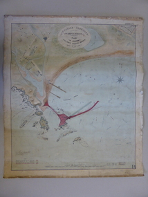 Warrnambool and District Historical Society Inc.
Document - Map, Warrnambool Harbour 1879, 1879
... This map shows the plans by eminent harbour engineer, Sir John Coode in 1879. ...Paper on linen map coloured, and depicting the harbour area of Warrnambool with the proposed breakwater plan in red. ...Sir john goode warrnambool harbour map warrnambool harbour map 1879 port of warrnambool map 1879 In oval at top, “Victorian Harbours Warrnambool plan to accompany Sir John Coode report dated 28th Feb 1879. ...This map shows the plans by eminent harbour engineer, Sir John Coode in 1879. Construction of the breakwater commenced in 1884 and was completed in 1890. Coode first visited Australia in 1872 when he commenced work with the Melbourne Harbour Trust to report on ways to improve Melbourne Port. He is considered one of the most eminent harbour engineers of the 19th century. His original plans for Warrnambool were revised because of cost but then subsequently found to be inadequate and later extended. This was not successful either and the harbour continues to have silting problems to this day. The Warrnambool Breakwater is of historical importance to Victoria and as this map depicts the original plans, it too has great historical significance. It is also significant with its association with Sir John Coode, who was one of the most important port engineers of the 19th century. He worked to improve ports along the Victorian coast including Portland, Geelong, Port Fairy and Lakes Entrance. While this map demonstrates the engineering skills of the era, it also reflects the limitations when natural elements are involved. Its Historical importance also lies in the depiction of items on the map which relate to Warrnambool’s early history. Paper on linen map coloured, and depicting the harbour area of Warrnambool with the proposed breakwater plan in red. It has Victorian Harbours information in oval at top of map. It shows depths of some areas.In oval at top, “Victorian Harbours Warrnambool plan to accompany Sir John Coode report dated 28th Feb 1879. Drawing No 2. Scale 500 feet to 1 inch at bottom centre. Sir John Coode signature in bottom left corner. A 33 A on bottom left reversesir john goode, warrnambool harbour map, warrnambool harbour map 1879, port of warrnambool map 1879 -
Whitehorse Historical Society Inc.
Document, Australian Social History House Research Assignment, 1986
... Real Estate Brochures, Maps, Photos, Floor Plans....Real Estate Brochures, Maps, Photos, Floor Plans....Real Estate Brochures, Maps, Photos, Floor Plans. Australian Social History House Research Assignment Document Document ...Social History of 2 Gordon Crescent, Blackburn,Social History of 2 Gordon Crescent, Blackburn, included - History of Blackburn, Architecture of the House and first owner, Thomas Richards Burrowes. Morton. Real Estate Brochures, Maps, Photos, Floor Plans.Social History of 2 Gordon Crescent, Blackburn, morton thomas richards burrowes, architecture -
Dandenong & District Historical Society
Drawing, Dandenong Town Hall Proposed Redevelopment Plans
... Proposed Redevelopment Plans - Drawings/Maps...Dandenong & District Historical Society 1st Floor, 39 Clow Street Dandenong melbourne Proposed Redevelopment Plans - Drawings/Maps Dandenong Town Hall Proposed Redevelopment Plans Drawing ...non-fiction -
 Bacchus Marsh & District Historical Society
Map, Limestone Reserve Parish of Merrimu 1888
... The surveyor's name who produced this plan is inscribed on the map and below this is the name P. ...Scale 4 chains to 1 inch. Part of a set of maps which are pasted into a bound volume containing 76 maps or plans in total. ...Scale 4 chains to 1 inch. Part of a set of maps which are pasted into a bound volume containing 76 maps or plans in total. ...Limestone deposits in the Coimadai area 10 kilometers north of Ballarat were first worked in the 1850s. The area was quarried for limestone for many years by various people and companies. The surveyor's name who produced this plan is inscribed on the map and below this is the name P. L. Alkemade, who presumably paid for the map to be produced. In 1886 Petrus Alkemade in partnership with Matthew Egan established the Alkemade Hydraulic Lime and Cement Company. The Alkemade family were involved in the limestone industry over several generations at Coimadai.Single page map showing part of the Limestone reserve near Coimadai in the Parish of Merrimu. Scale 4 chains to 1 inch. Part of a set of maps which are pasted into a bound volume containing 76 maps or plans in total. High resolution digital image stored on BMDHS computer network. Copy of plan surveyed by Mr. G? [illegible] an authorised surveyor on 17th July 1888. P. L. Alkemadebacchus marsh victoria maps, lime kilns coimadai, limestone, coimadai victoria maps, alkemade family coimadai -
 Orbost & District Historical Society
maps, early 1900s
... Anderson 17/11/00. 796.8 - A plan and specification on waxed paper. Shire of Orbost Cunninghame Road - signed by the shire engineer. 796.9 - This is a hand drawn map of Orbost Cunninghame Road, November 1896. 796.10 - This is a hand drawn cross-section of a culvert on the Orbost Cunninghame Road. 796.11 - This is a plan of a culvert on Tabbara Road, 13th January 1899 796.12 - This is a poster for an "Important Subdivisional Sale' for land near Orbost Bridge, on Wednesday 16th March 1921 at the rooms of H. ...A set of twelve maps, plans and land sale posters ....Orbost-land-1900s maps posters H.James A set of twelve maps, plans and land sale posters . maps ...796.1 - Crown Land Sale by auction in the township of Mallacoota on Wednesday January 1920 at 2pm. 796.2 - Snowy River farms , 630 acres of river flat land at Orbost on Wednesday April 28, 1909 at 2.30pm. 796.3 - Famous Orbost Flats - "Important Sale of Snowy River Land" , 900 acres subdivided into 13 choice farms on Wednesday 1st December 1920 at 2.30pm. 796.4 - "Second Great Sale in James' Subdivision", adjoining town of Orbost on 16th May, 1919 at 2pm. 796.5 - "Subdivisional Sale Brooklands Estate", 5 rich Snowy River farms on Wednesday 23rd February at 2.30 at Orbost on account of James Hossack Esq. 796.6 - "Subdivisional sale of Splendid Residence Sites and Handy Small Paddocks" adjoining the progressive town of Orbost on 5th March 1915 at 11am at the rooms of H.James & Co. 796.7 - This is a contract drawing on waxed paper. Crossing near Harbecks Cunninghame Signed and traced N. Anderson 17/11/00. 796.8 - A plan and specification on waxed paper. Shire of Orbost Cunninghame Road - signed by the shire engineer. 796.9 - This is a hand drawn map of Orbost Cunninghame Road, November 1896. 796.10 - This is a hand drawn cross-section of a culvert on the Orbost Cunninghame Road. 796.11 - This is a plan of a culvert on Tabbara Road, 13th January 1899 796.12 - This is a poster for an "Important Subdivisional Sale' for land near Orbost Bridge, on Wednesday 16th March 1921 at the rooms of H. James & Co. These documents are an important part of Orbost history in that they show how the town and surrounding areas were subdivided for farming and residential settlement.A set of twelve maps, plans and land sale posters .orbost-land-1900s maps posters h.james -
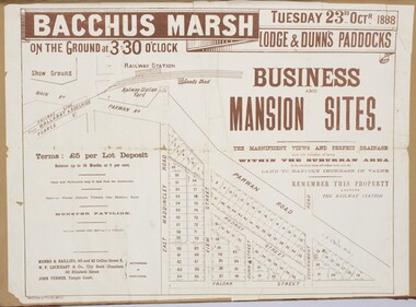 Bacchus Marsh & District Historical Society
Map, Bacchus Marsh Tuesday 23rd Oct. 1888, Lodge & Dunn's Paddocks 1888. Business and Mansion Sites
... This map was created as a plan for an auction of land close to the Bacchus Marsh Railway Station. ...The map is pasted into a bound volume containing 76 maps or plans in total. ...The map is pasted into a bound volume containing 76 maps or plans in total. ...This map was created as a plan for an auction of land close to the Bacchus Marsh Railway Station. The auction took place on 23 October 1888. 102 allotments of land from an area known as Lodge and Dunn's paddocks was offered for sale. The auction was conducted by auctioneers based in Melbourne and was advertised in Melbourne newspapers as well as in the Bacchus Marsh Express newspaper. The auction plan contains a range of details including the selling agents, Munro and Baillieu; W.P. Lockhart; and John Turner, all of Melbourne, deposit terms for purchases, price of railway passes for a return trip from Melbourne to Bacchus Marsh of 1 shilling, and a description of the land as having 'magnificent views and perfect drainage'. A single page paper map showing allotments of land for sale along the Parwan Road in Maddingley. The map is pasted into a bound volume containing 76 maps or plans in total. High resolution digital image stored on BMDHS computer network. At bottom on left side: 'Harston & Co. Lith, Melb.'land sales bacchus marsh, land sales maddingley, bacchus marsh victoria maps, maddingley victoria maps -
![Map, [Plan for road to give J. Allan access to permanent water at Coimadai] circa 1870s](/media/collectors/5e461d8021ea67224c82f2a1/items/67735190d671e67dd573a84c/item-media/6773533dd671e67dd573cd90/item-fit-380x285.jpg?cb=6) Bacchus Marsh & District Historical Society
Bacchus Marsh & District Historical SocietyMap, [Plan for road to give J. Allan access to permanent water at Coimadai] circa 1870s
... The date of this map or plan is uncertain but it appears to be from the early to mid 1870s. ...Scale 1 chain to 1 inch. Part of a set of maps which are pasted into a bound volume containing 76 maps or plans in total. ...Scale 1 chain to 1 inch. Part of a set of maps which are pasted into a bound volume containing 76 maps or plans in total. ...The date of this map or plan is uncertain but it appears to be from the early to mid 1870s. One of the landholders identified on the plan, James Allan of Coimadai died suddenly on the 9th July, 1874 (see Bacchus Marsh Express, 11 July, 1874, page. 3). There are mentions of an Allans Road at Coimadai in the Bacchus Marsh Express between 1887 and 1942.Single page map showing an excision of land belonging to Charles Ross which was selected to construct a road to give another landholder, J. Allan access to permanent water. Scale 1 chain to 1 inch. Part of a set of maps which are pasted into a bound volume containing 76 maps or plans in total. High resolution digital image stored on BMDHS computer network. Plan showing Excisions from Ross's selection and 1 chain road thro' the said selection in Coimadai to give J. Allan access to permanent water. Alistair ?? Shire Eng? 6?/5/7?coimadai victoria maps, coimadai roads and streets -
 Sunshine and District Historical Society Incorporated
Plan - H.V. McKay Massey Harris & Massey Ferguson Maps
... McKay Massey Harris Maps Site Plan 1933 3152.04 - H.V. McKay Massey Harris Maps 1924 Site Plan 3152.05 - H.V. ...McKay Massey Harris Maps Site Plan 1933 3152.04 - H.V. McKay Massey Harris Maps 1924 Site Plan 3152.05 - H.V. ...3152.01 - H.V. McKay Massey Harris Maps 1922 Site Plan 3152.02 - H.V. McKay Massey Harris Maps Factory Gas And Water Plants 1941 3152.03 - H.V. McKay Massey Harris Maps Site Plan 1933 3152.04 - H.V. McKay Massey Harris Maps 1924 Site Plan 3152.05 - H.V. McKay Massey Harris Maps 1927 Site Plan 3152.06 - H.V. McKay Massey Harris Maps 1956 Type Of Buildings Site Plan 3152.07 - H.V. McKay Massey Harris Maps 1986 Restricted Area Construction Plan 3152.08 - H.V. McKay Massey Harris Maps Factory Gas And Water Control Plan 1941 3152.09 - H.V. McKay Massey Harris Maps Aerial Photoh.v. mckays massey ferguson, sunshine harvester works -
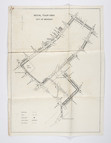 City of Greater Bendigo - Civic Collection
Document - Set of correspondence re Queen Elizabeth tour of Bendigo, Mrs T. R. Mannix, February 8th, 1954
... The response from the Commissioner included typed plans of the event and maps of the royal tour through the streets of Bendigo starting and finishing at the train station....Set of correspondence including typed gatefold letter, typed plans for placement of visitors and role of the military and maps of CBD Bendigo and of Upper Reserve....The response from the Commissioner included typed plans of the event and maps of the royal tour through the streets of Bendigo starting and finishing at the train station. ...Correspondence between Mrs T. R. Mannix, Swan Hill Wolf Cub Pack master to District Scout Commissioner Mr J. I. Samson for an invitation to be included with the local scout groups in functions to welcome Queen Elizabeth and the Duke of Edinburgh to Bendigo on Friday, the 5th of March 1954. The response from the Commissioner included typed plans of the event and maps of the royal tour through the streets of Bendigo starting and finishing at the train station.Set of correspondence including typed gatefold letter, typed plans for placement of visitors and role of the military and maps of CBD Bendigo and of Upper Reserve.queen elizabeth, duke of edinburgh, boy scout association, mayor clayton, city of greater bendigo royal visits, city of greater bendigo community groups, city of greater bendigo tourism