Showing 109 items matching " natural disasters"
-
 Orbost & District Historical Society
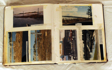
album, Our Natural Disasters Hailstorm 1991 Floods 1934-1998, between 1998 and 2003?
... Our Natural Disasters Hailstorm 1991 Floods 1934-1998...On the cover is the title Our Natural Disasters. It contains 54 pages of photos of local natural disasters - flood, fire and hail. ...On the cover is the title Our Natural Disasters. It contains 54 pages of photos of local natural disasters - flood, fire and hail. ...This album was compiled for the use of visitors to the Slab Hut (Orbost Visitor Information Centre).This album is a useful research tool.A photo album with a maroon cover with gold embossing. On the cover is the title Our Natural Disasters. It contains 54 pages of photos of local natural disasters - flood, fire and hail. The photos are taped in.slab-hut orbost-disasters album orbost-floods-fires-hailstorms -
 Sunshine and District Historical Society Incorporated
Archive - Man Made & Natural Accidents Disasters
... Man Made & Natural Accidents Disasters...Collection of docments on Man Made, Natural Disasters & Fatalities...Albans|Newpaper Article Star Weekly 7th February 2023 Motorcyclist dies Keilor Park Drive Collection of docments on Man Made, Natural Disasters & Fatalities Archive Man Made & Natural Accidents Disasters ...Collection of Newspaper Articles 70 Swan Drive Derrimut Fire|Collection of Newspaper Articles Coode Island Fire|Collection Newspaper Articles Westage Bridge Collapse including the construction sequence of the steel spans|Newpaper Article Star Weekly 4th October 2022 Pedestrian killed Ballarat Rd Sunshine|Newpaper Article Star Weekly 4th July 2023 Teenage boy dies after attack St. Albans|Newpaper Article Star Weekly 7th February 2023 Motorcyclist dies Keilor Park Driveaccident, disaster -
 Bendigo Historical Society Inc.
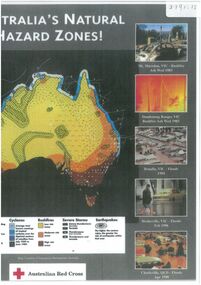
Document - Map outlining Australia's natural hazard zones
... ...natural disasters...Legend demonstrates different types of natural disasters and zones in which they are more likely to occur. ...Legend demonstrates different types of natural disasters and zones in which they are more likely to occur. ...John Perry collection. Laminated document. Color. Map of Australia in the middle of document surrounded by 10 images of natural disasters that have occurred in Australia in Cairns, Darwin, Cleve, Northam, Central Queensland, Mt. Macedon, Dandenong Ranges, Benalla, Healesville, and Charleville. Legend demonstrates different types of natural disasters and zones in which they are more likely to occur. Has logo of Australian Red Cross at the bottom of document. map, tornado, cyclone, flood, drought, natural disasters -
 Unions Ballarat
Victorian history and politics : European settlement to 1939 : a survey of the literature, Monie, Joanna, 1982
... ...natural disasters...Contents - Volume 2 Transport and Communications Natural Disasters Women Immigration and Demography Aborigines Social Welfare Health Education Libraries and Museums Leisure Press The Administration of Justice Bushrangers Appendix...Contents - Volume 2 Transport and Communications Natural Disasters Women Immigration and Demography Aborigines Social Welfare Health Education Libraries and Museums Leisure Press The Administration of Justice Bushrangers Appendix Relevant to the history of Victorian state history, social customs and politics. transport communications natural disasters women immigration demography aboriginals welfare health libraries museums leisure press law law enforcement bushrangers Front cover: Title and author name. ...Literature review. Contents - Volume 2 Transport and Communications Natural Disasters Women Immigration and Demography Aborigines Social Welfare Health Education Libraries and Museums Leisure Press The Administration of Justice Bushrangers AppendixRelevant to the history of Victorian state history, social customs and politics.Paperback book. Front cover: red background; picture of horses and carts - historical setting; white and black text. Back cover: picture of Bignell's New Hotel with flag.Front cover: Title and author name. transport, communications, natural disasters, women, immigration, demography, aboriginals, welfare, health, libraries, museums, leisure, press, law, law enforcement, bushrangers -
 Halls Gap & Grampians Historical Society
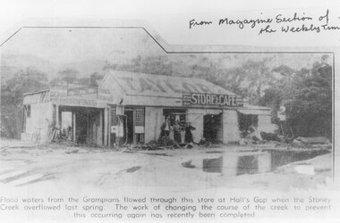
Document - B/W article (magazine/newspaper), C 1930s
... ...NATURAL DISASTERS...BUILDINGS Shops NATURAL DISASTERS Floods A newspaper cutting. It shows a building with three women standing in front of it. ...A photo, that appeared in the magazine section of the Weekly Times in 1937, of Taylor's General Store and Cafe after a flood of the Stoney Creek. The creek flowed through the store at the height of the flood. The course of the creek was changed after this flood to prevent this happening again.A newspaper cutting. It shows a building with three women standing in front of it. The building has TAYLOR painted on the roof and a sign saying "Store & Cafe" there is a large pool of water in the foreground. Trees and hills can be vaguely seen in the background.buildings, shops, natural disasters, floods -
 Orbost & District Historical Society
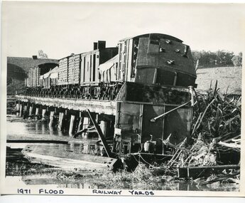
black and white photograph, February 1971
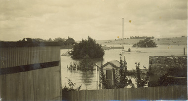
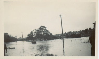
... floods-1971-orbost orbost-railway natural-disasters-orbost...It is connected to the history of the railway in East Gippsland. floods-1971-orbost orbost-railway natural-disasters-orbost on front - "1971 Flood, Railway Yards" A large black / white photograph of flooded railway yards with a train engine stranded on a small section of track surrounded by water and debris. black and white photograph ...The 1971 flood was the the worst flood on record. At Jarrahmond it was at least 11 metres and up to one and a half kilometres wide on the flats causing enormous damage to the flood plain. Records say that "The brown floodwater stain in Bass Strait could be seen from passing airliners." Considerable damage was done to railway infrastructure, roads and farms. More information from the APRIL, 2008 newsletter by John Phillips. (see orbosthistory.com.au) The railway line was destroyed and was not expected to be opened for a fortnight. Orbost was cut off by 50 square miles of Snowy River floodwater. This train was being shunted across the viaduct when waters smashed through washing away several trucks sending the crew running for their lives.This is pictorial evidence of a significant local event. It is connected to the history of the railway in East Gippsland.A large black / white photograph of flooded railway yards with a train engine stranded on a small section of track surrounded by water and debris.on front - "1971 Flood, Railway Yards"floods-1971-orbost orbost-railway natural-disasters-orbost -
 Orbost & District Historical Society
black / white photograph, January 1934
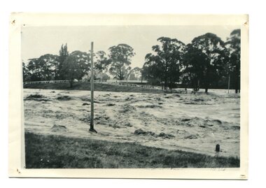
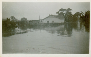
... orbost-floods-1934 natural-disasters-floods...This item is a pictorial record of the 1934 floods, a significant part of Orbost's history. orbost-floods-1934 natural-disasters-floods A black / white photograph of swirling floodwaters with township in the background. black / white photograph ...Damage estimated at £500,000 was caused by the 1934 floods in the Orbost district. This 1934 flood was devastating, destroying a section of the 1922 Orbost bridge, wrecking fences, bridges and roads, dumping silt and debris on the rich river flats and drowning cattle. This photograph shows Lochiel Lagoon ( the billabong) in the foreground. Ten minutes after this photograph was taken, the centre span of the Orbost Bridge was washed away.This item is a pictorial record of the 1934 floods, a significant part of Orbost's history.A black / white photograph of swirling floodwaters with township in the background.orbost-floods-1934 natural-disasters-floods -
 Orbost & District Historical Society
black and white photograph, January 1934
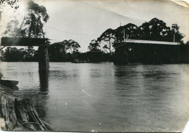
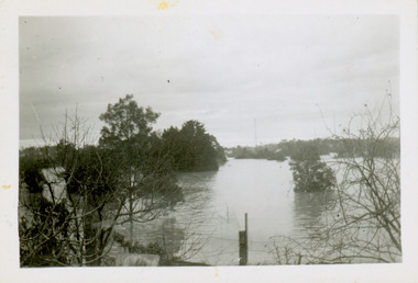
... orbost-floods-1934 natural-disasters-floods snowy-river-bridge...This item is a pictorial record of the 1934 floods, a significant part of Orbost's history. orbost-floods-1934 natural-disasters-floods snowy-river-bridge A black / white photograph showing the flood damage to the Snowy River Bridge. ...Damage estimated at £500,000 was caused by the 1934 floods in the Orbost district. This 1934 flood was devastating, destroying a section of the 1922 Orbost bridge, wrecking fences, bridges and roads, dumping silt and debris on the rich river flats and drowning cattle. The centre span of the Orbost Bridge was washed away. This item is a pictorial record of the 1934 floods, a significant part of Orbost's history.A black / white photograph showing the flood damage to the Snowy River Bridge. There is a gap in the bridge where the centre span has been washed away. In the background is a punt.orbost-floods-1934 natural-disasters-floods snowy-river-bridge -
Lakes Entrance Historical Society
Book, The Maryborough Region Bushfire January 14 1985, 1985
... Natural Disasters...Lakes Entrance Historical Society 4 Marine Parade Lakes Entrance gippsland Natural Disasters Photography The story of the fire which devastated the Central Victorian region on Monday, January 14, 1985.Towns and locations were Bung Bong, Amherst, Talbot, Dunach, Daisy Hill, McCallums Creek, Majorca, Bristol Hill, Maryborough and Carisbrook. ...The story of the fire which devastated the Central Victorian region on Monday, January 14, 1985.Towns and locations were Bung Bong, Amherst, Talbot, Dunach, Daisy Hill, McCallums Creek, Majorca, Bristol Hill, Maryborough and Carisbrook. Illustrated withnatural disasters, photography -
Lakes Entrance Historical Society
Book, Commonwealth of Australia, Hazards, Disasters and Survival, 1997
... ... Natural Disasters...Lakes Entrance Historical Society 4 Marine Parade Lakes Entrance gippsland Information Natural Disasters A booklet to promote awareness of a wide range of hazards and disasters, and education of students and the community regarding survival through preparedness, risk reduction and management. ...A booklet to promote awareness of a wide range of hazards and disasters, and education of students and the community regarding survival through preparedness, risk reduction and management. Case studies of fires, cyclones, landslides, and a list of Austrainformation, natural disasters -
Lakes Entrance Historical Society
Book, Colwell, Max, The Big Rivers' Murray, Darling, Murrumbidgee, 1978
... ... Natural Disasters...Lakes Entrance Historical Society 4 Marine Parade Lakes Entrance gippsland Waterways Catchments Natural Disasters Bridges Commerce Land Settlement The Murray-Darling basin river system - called the rivers of life. ...The Murray-Darling basin river system - called the rivers of life. Victoria, New South Wales and South Australia. 32,000 Kms. along the system.waterways, catchments, natural disasters, bridges, commerce, land settlement -
Lakes Entrance Historical Society
Book, Mehlert Philip, Cossticks Weir, 2002
... Natural Disasters...Lakes Entrance Historical Society 4 Marine Parade Lakes Entrance gippsland Natural Disasters Dams Research, interpretation, Cossticks Weir Book Mehlert Philip ...Research, interpretation,natural disasters, dams -
Lakes Entrance Historical Society
Book, Barned, Kim, Tambo Upper Low Level Bridge, 2003
... ... Natural Disasters...Lakes Entrance Historical Society 4 Marine Parade Lakes Entrance gippsland Bridges Waterways Natural Disasters Research, interpretation and management recommendations for the Tambo Upper Low Level Bridge, East Gippsland,Victoria, by a Forestec student. ...Research, interpretation and management recommendations for the Tambo Upper Low Level Bridge, East Gippsland,Victoria, by a Forestec student.bridges, waterways, natural disasters -
Lakes Entrance Historical Society
Book, Orbost Historical Society Inc, Barns of the Snowy River Orbost, 2006
... ... Natural Disasters...Lakes Entrance Historical Society 4 Marine Parade Lakes Entrance gippsland Land Settlement Agriculture Natural Disasters Transport Ngaire Donald May Leatch Documents the distinctive slatted barns of the Lower Snowy River, Orbost, Victoria. ...Documents the distinctive slatted barns of the Lower Snowy River, Orbost, Victoria. Includes sketch maps, barn plans, history of area and families and personal ineterviews.Ngaire Donald May Leatchland settlement, agriculture, natural disasters, transport -
Lakes Entrance Historical Society
Book, East Gippsland Catchment Management, Flood Event Photos 2007, 2007
... Natural Disasters...Lakes Entrance Historical Society 4 Marine Parade Lakes Entrance gippsland Natural Disasters Waterways Township A pictorial record in colour of the widespread damaging floods in East Gippsland in June 2007 . ...A pictorial record in colour of the widespread damaging floods in East Gippsland in June 2007 . Spiral bound bookletnatural disasters, waterways, township -
Lakes Entrance Historical Society
Book, Glenvale School Committee, From Fire to Flood, 2007
... Natural Disasters...Lakes Entrance Historical Society 4 Marine Parade Lakes Entrance gippsland Natural Disasters A pictorial record which graphically represents the devastation caused by fire and flood in Gippsland during 2006-2007. ...A pictorial record which graphically represents the devastation caused by fire and flood in Gippsland during 2006-2007.natural disasters -
Lakes Entrance Historical Society
Book, Timber Workers, 2001
... ... Natural Disasters...Lakes Entrance Historical Society 4 Marine Parade Lakes Entrance gippsland Timber Industry Schools Natural Disasters A souvenir booklet of the Rubicon Timber Workers reunion at Alexandra, Victoria. ...A souvenir booklet of the Rubicon Timber Workers reunion at Alexandra, Victoria. Contains short references to the workers, schools, and the hardships of life in this remote area especially for the women.timber industry, schools, natural disasters -
Kew Historical Society Inc
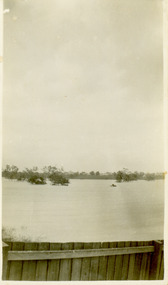
Collection, Floods in North Kew (Series), 1929–1934
... ...Natural disasters -- Kew...Changes in the impact of natural disasters could occur due to a number of factors. ...Flooding of the Yarra Valley, including that section of the Yarra bordering Kew and Kew East in the north and west of the municipality, was a regular occurrence. Extreme flood events of the Yarra River are recorded to have occurred in 1891, 1901, 1916, 1923 and 1934. The Municipality of Kew's response to these floods was to enact planning decisions restricting residential development in flood prone areas following the floods of 1916, 1921 and 1934. While floods continued after the development of the Upper Yarra Reservoir (construction 1948-57), the regularity and extent of these inundations diminished. Natural disasters had an impact on the development and settlement of Melbourne and its suburbs. Flooding in the Melbourne region was a regular event in the nineteenth and for most of the twentieth centuries. Changes in the impact of natural disasters could occur due to a number of factors. This collection of small snapshots, mostly taken from Kellett Grove in North Kew, provide provenanced evidence of flooding in the area before the development of the unnatural flood barrier that is the Eastern Freeway.Collection of 16 monochrome photographs, annotated on verso by different hands, of the flooding of the River Yarra in North Kew in the third and fourth decades of the twentieth century [1920s & 1930s]. Individual photos include the dates of different floods. Many of the photos were taken from the rear of 8 Kellett Grove; a house still extant in 2023yarra river -- north kew, floods -- yarra valley, floods -- north kew, floods -- 1929, floods -- 1934, natural disasters -- kew -
 Kew Historical Society Inc
Photograph - Flooding of the Yarra River in North Kew, 1934
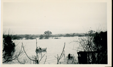
... ...natural disasters -- kew...Prior to urban development, the area since European settlement and the first land sales in the district in the 1840s, had been used for dairy farming. yarra river -- north kew floods -- yarra valley floods -- north kew floods -- 1929 floods -- 1934 natural disasters -- kew Verso: 2/12/34 / TAKEN FROM OUR RAMP Small sepia snapshot taken from the river ramp of a house at 8 Kellett Grove, in what was then known as North Kew. ...North Kew, now divided between Kew and Kew East, bordered the Yarra River. As such, it was a region subject to flooding in the Yarra Valley. Development beyond this point (ie Kellett Grove) was limited by the City of Kew's planning regulations. Prior to urban development, the area since European settlement and the first land sales in the district in the 1840s, had been used for dairy farming. Small sepia snapshot taken from the river ramp of a house at 8 Kellett Grove, in what was then known as North Kew. The point of view is from a backyard looking towards Fairfield. Beyond the fence line are two almost submerged houses. A number of people are in a motor driven boat midstream. Fairfield at this period, (ie 1934) was noted for its limited river side development. Verso: 2/12/34 / TAKEN FROM OUR RAMPyarra river -- north kew, floods -- yarra valley, floods -- north kew, floods -- 1929, floods -- 1934, natural disasters -- kew -
 Kew Historical Society Inc
Photograph - Flooding of the Yarra River in North Kew, 1934
... ...natural disasters -- kew...Prior to urban development, the area since European settlement and the first land sales in the district in the 1840s, had been used for dairy farming. yarra river -- north kew floods -- yarra valley floods -- north kew floods -- 1934 natural disasters -- kew Verso: BACKYARD NTH. KEW Small sepia snapshot taken from the back yard of a house at 8 Kellett Grove, in what was then known as North Kew. ...North Kew, now divided between Kew and Kew East, bordered the Yarra River. As such, it was a region subject to flooding in the Yarra Valley. Development beyond this point (ie Kellett Grove) was limited by the City of Kew's planning regulations. Prior to urban development, the area since European settlement and the first land sales in the district in the 1840s, had been used for dairy farming. Small sepia snapshot taken from the back yard of a house at 8 Kellett Grove, in what was then known as North Kew. The point of view is from a backyard looking towards Fairfield. Floodwaters have submerged the fence and a clothes line. Verso: BACKYARD NTH. KEWyarra river -- north kew, floods -- yarra valley, floods -- north kew, floods -- 1934, natural disasters -- kew -
 Kew Historical Society Inc
Photograph - Flooding of the Yarra River in North Kew, 1934
... ...natural disasters -- kew...Prior to urban development, the area since European settlement and the first land sales in the district in the 1840s, had been used for dairy farming. yarra river -- north kew floods -- yarra valley floods -- north kew floods -- 1934 natural disasters -- kew Verso: 8 KELLETT GROVE Small sepia snapshot taken from the back yard of a house at 8 Kellett Grove, in what was then known as North Kew. ...North Kew, now divided between Kew and Kew East, bordered the Yarra River. As such, it was a region subject to flooding in the Yarra Valley. Development beyond this point (ie Kellett Grove) was limited by the City of Kew's planning regulations. Prior to urban development, the area since European settlement and the first land sales in the district in the 1840s, had been used for dairy farming. Small sepia snapshot taken from the back yard of a house at 8 Kellett Grove, in what was then known as North Kew. The point of view is from a backyard looking towards Fairfield. Verso: 8 KELLETT GROVEyarra river -- north kew, floods -- yarra valley, floods -- north kew, floods -- 1934, natural disasters -- kew -
 Kew Historical Society Inc
Photograph - Flooding of the Yarra River in North Kew, 1934
... ...natural disasters -- kew...Prior to urban development, the area since European settlement and the first land sales in the district in the 1840s, had been used for dairy farming. yarra river -- north kew floods -- yarra valley floods -- north kew floods -- 1934 natural disasters -- kew Verso: OUR BACKYARD 8 KELLETT GROVE Small sepia snapshot taken from the back yard of a house at 8 Kellett Grove, in what was then known as North Kew. ...North Kew, now divided between Kew and Kew East, bordered the Yarra River. As such, it was a region subject to flooding in the Yarra Valley. Development beyond this point (ie Kellett Grove) was limited by the City of Kew's planning regulations. Prior to urban development, the area since European settlement and the first land sales in the district in the 1840s, had been used for dairy farming. Small sepia snapshot taken from the back yard of a house at 8 Kellett Grove, in what was then known as North Kew. The point of view is from a backyard looking towards Fairfield. Verso: OUR BACKYARD 8 KELLETT GROVEyarra river -- north kew, floods -- yarra valley, floods -- north kew, floods -- 1934, natural disasters -- kew -
 Kew Historical Society Inc
Photograph - Flooding of the Yarra River in North Kew, 1934
... ...natural disasters -- kew...Prior to urban development, the area since European settlement and the first land sales in the district in the 1840s, had been used for dairy farming. yarra river -- north kew floods -- yarra valley floods -- north kew floods -- 1934 natural disasters -- kew Verso: OUR BACKYARD / Stamped 3 163 Small sepia snapshot of floodwaters taken from near Kellett Grove, in what was then known as North Kew. ...North Kew, now divided between Kew and Kew East, bordered the Yarra River. As such, it was a region subject to flooding in the Yarra Valley. Development beyond this point (ie Kellett Grove) was limited by the City of Kew's planning regulations. Prior to urban development, the area since European settlement and the first land sales in the district in the 1840s, had been used for dairy farming. Small sepia snapshot of floodwaters taken from near Kellett Grove, in what was then known as North Kew. The point of view is from a backyard looking towards Fairfield. In the foreground ar two men in a rowboat.Verso: OUR BACKYARD / Stamped 3 163yarra river -- north kew, floods -- yarra valley, floods -- north kew, floods -- 1934, natural disasters -- kew -
 Kew Historical Society Inc
Photograph - Flooding of the Yarra River in North Kew, 1934
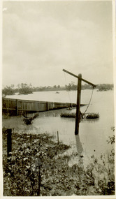
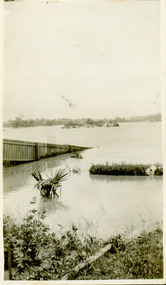
... ...natural disasters -- kew...Prior to urban development, the area since European settlement and the first land sales in the district in the 1840s, had been used for dairy farming. yarra river -- north kew floods -- yarra valley floods -- north kew floods -- 1934 natural disasters -- kew willsmere road Verso: WILLSMERE ROAD NORTH KEW / Stamped 3 163 Small sepia snapshot of floodwaters taken from near Willsmere Road, in what was then known as North Kew. ...North Kew, now divided between Kew and Kew East, bordered the Yarra River. As such, it was a region subject to flooding in the Yarra Valley. Development beyond this point (ie Kellett Grove) was limited by the City of Kew's planning regulations. Prior to urban development, the area since European settlement and the first land sales in the district in the 1840s, had been used for dairy farming. Small sepia snapshot of floodwaters taken from near Willsmere Road, in what was then known as North Kew. The point of view is looking towards Fairfield. In the foreground are two figures viewing a group in a rowboat in the middle of the flooded river. Semi-submerged street lighting indicates that entire streets had been. overwhelmed by the flood waters. Verso: WILLSMERE ROAD NORTH KEW / Stamped 3 163yarra river -- north kew, floods -- yarra valley, floods -- north kew, floods -- 1934, natural disasters -- kew, willsmere road -
 Kew Historical Society Inc
Photograph - Flooding of the Yarra River in North Kew, 1934
... ...natural disasters -- kew...Prior to urban development, the area since European settlement and the first land sales in the district in the 1840s, had been used for dairy farming. yarra river -- north kew floods -- yarra valley floods -- north kew floods -- 1934 natural disasters -- kew willsmere road Verso: HYATTS HOUSE / WILLSMERE ROAD / Stamped 3 163 Small sepia snapshot of floodwaters in North Kew. ...North Kew, now divided between Kew and Kew East, bordered the Yarra River. As such, it was a region subject to flooding in the Yarra Valley. Development beyond this point (ie Kellett Grove) was limited by the City of Kew's planning regulations. Prior to urban development, the area since European settlement and the first land sales in the district in the 1840s, had been used for dairy farming. Small sepia snapshot of floodwaters in North Kew. The point of view is of two houses belonging to local families that were surrounded by floodwater. Verso: HYATTS HOUSE / WILLSMERE ROAD / Stamped 3 163yarra river -- north kew, floods -- yarra valley, floods -- north kew, floods -- 1934, natural disasters -- kew, willsmere road -
 Kew Historical Society Inc
Photograph - Flooding of the Yarra River in North Kew, 1934
... ...natural disasters -- kew...Prior to urban development, the area since European settlement and the first land sales in the district in the 1840s, had been used for dairy farming. yarra river -- north kew floods -- yarra valley floods -- north kew floods -- 1934 natural disasters -- kew willsmere road Verso: OUR BACKYARD / Stamped 52 Small sepia snapshot of floodwaters in North Kew, from the rear of 8 Kellett Grove. ...North Kew, now divided between Kew and Kew East, bordered the Yarra River. As such, it was a region subject to flooding in the Yarra Valley. Development beyond this point (ie Kellett Grove) was limited by the City of Kew's planning regulations. Prior to urban development, the area since European settlement and the first land sales in the district in the 1840s, had been used for dairy farming. Small sepia snapshot of floodwaters in North Kew, from the rear of 8 Kellett Grove. Verso: OUR BACKYARD / Stamped 52yarra river -- north kew, floods -- yarra valley, floods -- north kew, floods -- 1934, natural disasters -- kew, willsmere road -
 Kew Historical Society Inc
Photograph - Grandfather and granddaughter in the yard of 8 Kellett Grove, Kew, 1934
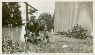
... ...natural disasters -- kew...Vivid photograph contrasting domestic life and relationships with natural disasters such as the flood of 1934. yarra river -- north kew floods -- yarra valley floods -- north kew floods -- 1934 natural disasters -- kew willsmere road Verso: GRANDDAD AND I IN BACKYARD Small sepia snapshot of a grandfather and granddaughter sitting in the backyard of 8 Kellett Grove, North Kew, with the floodwaters stretching behind them. ...North Kew, now divided between Kew and Kew East, bordered the Yarra River. As such, it was a region subject to flooding in the Yarra Valley. Development beyond this point (ie Kellett Grove) was limited by the City of Kew's planning regulations. Prior to urban development, the area since European settlement and the first land sales in the district in the 1840s, had been used for dairy farming. Vivid photograph contrasting domestic life and relationships with natural disasters such as the flood of 1934.Small sepia snapshot of a grandfather and granddaughter sitting in the backyard of 8 Kellett Grove, North Kew, with the floodwaters stretching behind them.Verso: GRANDDAD AND I IN BACKYARDyarra river -- north kew, floods -- yarra valley, floods -- north kew, floods -- 1934, natural disasters -- kew, willsmere road -
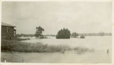
 Kew Historical Society Inc
Photograph - Submerged houses in River Avenue, North Kew, 1934
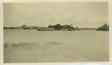
... ...natural disasters -- kew...Vivid photograph contrasting domestic life and relationships with natural disasters such as the flood of 1934. yarra river -- north kew floods -- yarra valley floods -- north kew floods -- 1934 natural disasters -- kew Verso: COES & HYATTS ROOF / RIVER AVENUE / Stamped: 6414 Small sepia snapshot of two submerged houses belonging to local families in River Avenue, North Kew, during the 1934 floods. ...North Kew, now divided between Kew and Kew East, bordered the Yarra River. As such, it was a region subject to flooding in the Yarra Valley. Development beyond this point (ie Kellett Grove) was limited by the City of Kew's planning regulations. Prior to urban development, the area since European settlement and the first land sales in the district in the 1840s, had been used for dairy farming. Vivid photograph contrasting domestic life and relationships with natural disasters such as the flood of 1934.Small sepia snapshot of two submerged houses belonging to local families in River Avenue, North Kew, during the 1934 floods. The view is presumably from near Kellett Grove looking north towards Fairfield.Verso: COES & HYATTS ROOF / RIVER AVENUE / Stamped: 6414yarra river -- north kew, floods -- yarra valley, floods -- north kew, floods -- 1934, natural disasters -- kew -
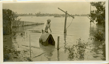 Kew Historical Society Inc
Photograph - Flooding of the Yarra River in North Kew, 1934
... ...natural disasters -- kew...Vivid photograph contrasting domestic life and relationships with natural disasters such as the flood of 1934. yarra river -- north kew floods -- yarra valley floods -- north kew floods -- 1934 natural disasters -- kew Verso: DAD SECURING NIPPY'S DOG KENNEL / Stamped 6414 Small sepia snapshot of the donors grandfather rescuing the family dog's kennel from rising floodwaters at the rear of 8 Kellett Grove, North Kew, . ...North Kew, now divided between Kew and Kew East, bordered the Yarra River. As such, it was a region subject to flooding in the Yarra Valley. Development beyond this point (ie Kellett Grove) was limited by the City of Kew's planning regulations. Prior to urban development, the area since European settlement and the first land sales in the district in the 1840s, had been used for dairy farming. Vivid photograph contrasting domestic life and relationships with natural disasters such as the flood of 1934.Small sepia snapshot of the donors grandfather rescuing the family dog's kennel from rising floodwaters at the rear of 8 Kellett Grove, North Kew, .Verso: DAD SECURING NIPPY'S DOG KENNEL / Stamped 6414yarra river -- north kew, floods -- yarra valley, floods -- north kew, floods -- 1934, natural disasters -- kew -
 Kew Historical Society Inc
Photograph - Flooding of the Yarra River in North Kew, 1934
... ...natural disasters -- kew...Prior to urban development, the area since European settlement and the first land sales in the district in the 1840s, had been used for dairy farming. . yarra river -- north kew floods -- yarra valley floods -- north kew floods -- 1934 natural disasters -- kew Verso: THE SIDE OF RYANS Small sepia snapshot of a local family's house in what was then River Avenue, North Kew being surrounded by floodwaters. ...North Kew, now divided between Kew and Kew East, bordered the Yarra River. As such, it was a region subject to flooding in the Yarra Valley. Development beyond this point (ie Kellett Grove) was limited by the City of Kew's planning regulations. Prior to urban development, the area since European settlement and the first land sales in the district in the 1840s, had been used for dairy farming. .Small sepia snapshot of a local family's house in what was then River Avenue, North Kew being surrounded by floodwaters.Verso: THE SIDE OF RYANSyarra river -- north kew, floods -- yarra valley, floods -- north kew, floods -- 1934, natural disasters -- kew