Showing 956 items matching " parish map"
-
 Ringwood and District Historical Society
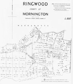
Map, Parish map of Ringwood, County of Mornington - 1878
... Parish map of Ringwood, County of Mornington - 1878....Black and white copy of part of Parish Map Collection...Written on rear of backing sheet: "SLV Parish Map Collection Vol.23, Fol.64."...Written on rear of backing sheet: "SLV Parish Map Collection Vol.23, Fol.64." Black and white copy of part of Parish Map Collection Parish map of Ringwood, County of Mornington - 1878. ...Black and white copy of part of Parish Map CollectionWritten on rear of backing sheet: "SLV Parish Map Collection Vol.23, Fol.64." -
 Ringwood and District Historical Society
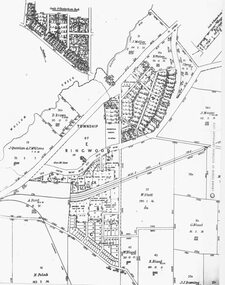
Map, Parish Map - Township of Ringwood - 1890
... Parish Map - Township of Ringwood - 1890....Black and white copy of part of Parish Map Collection...Written on rear of backing sheet: "SLV Parish Map Collection. Vol.67, Fol. 43, 1890." ...Black and white copy of part of Parish Map Collection Parish Map - Township of Ringwood - 1890. ...Black and white copy of part of Parish Map CollectionWritten on rear of backing sheet: "SLV Parish Map Collection. Vol.67, Fol. 43, 1890." -
 Bendigo Historical Society Inc.
Map - Mandurang and district Parish Map
... Mandurang and district Parish Map......parish map...Waxed paper, black text map showing lease holdings numbers 7496 and 7540, with areas noted. Parish of Sandhurst written on top of map; Parish of Mandurang on bottom. ...Map Mandurang and district Parish Map ...Waxed paper, black text map showing lease holdings numbers 7496 and 7540, with areas noted. Parish of Sandhurst written on top of map; Parish of Mandurang on bottom. Plan forms part of the Margaret Roberts Collection.gold mining, gold, mandurang, parish map -
 Ringwood and District Historical Society
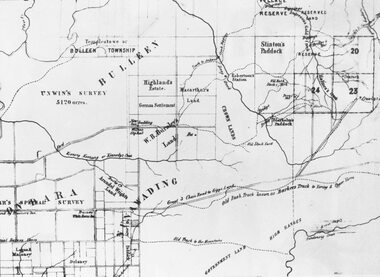
Map, Parish Map including Bulleen, Nunawading, and eventual site of Ringwood. c1855
... Parish Map including Bulleen, Nunawading, and eventual site of Ringwood. c1855...Black and white copy of part of Parish Map collection. Volume 3, Folio 105....Black and white copy of part of Parish Map collection. Volume 3, Folio 105. Parish Map including Bulleen, Nunawading, and eventual site of Ringwood. c1855 Map ...Black and white copy of part of Parish Map collection. Volume 3, Folio 105.Note on rear of backing sheet: "Ringwood is south of Lots 23 & 24, RHS. -
 Kiewa Valley Historical Society
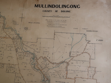
Parish Map - Mullindolingong, County of Bogong
... Parish Map - Mullindolingong, County of Bogong...Parish of Mullindolingong map...There is no date on the map. Parish Map - Mullindolingong, County of Bogong ...The Department of Lands regularly updated the occupiers with leases or licences of the land.The names of the early settlers of the Kiewa Valley occupying land by lease or licence are shown. Many of these familie's descendants still live in the Kiewa Valley.Government (Lands Department?) cloth map showing the leases or licenses of occupiers of the land in the valley. The Kiewa River is shown in blue and roads in yellow. There is no date on the map.parish of mullindolingong map, settlers of the kiewa valley -
 Kiewa Valley Historical Society
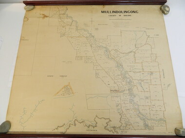
Map - Kiewa Valley, Parish Map of Mullindolingong, 12/10/1906
... Parish Map of Mullindolingong...parish of mullindolingong map; ryder family; early settlers;...The map shows the names of people living in the parish of Mullindolingong in 1906. ...The map shows the current leases and licences and when they were held by during this period, circa 1906. Parish Map of Mullindolingong Map - Kiewa Valley ...The map shows the names of people living in the parish of Mullindolingong in 1906. These people had leases or licences giving the reader an insight into the number of people in the area and an understanding of the size of their holdings. Infrastructure is also given including shops, schools, churches etc. Presumably it was used by the Ryder family.This map gives an historical insight into the parish of Mullindolingong as it names people and the infrastructure - roads, buildings etc. as it was in 1906. This enables the reader to compare the area at the time with other times and other places and to have an understanding of the early settlers in the area.This is a very old paper or parchment map with wooden rods top and bottom. The top rod has ribbons attached to enable hanging. The map shows the current leases and licences and when they were held by during this period, circa 1906.Mullindolingong County of Bogong. This plan has been prepared by The Most Reliable Data in the Possession of the Department up to the date of its Compilation. Information respecting Leases or Licences which await Final Completion is not recorded.parish of mullindolingong map; ryder family; early settlers; -
 Stawell Historical Society Inc
Map - Parish Map, Barkley County of Kara Kara 1920's, 1920's ?
... Parish Map...Paper map of Parish of Barkely...Melbourne 22.11.2 Paper map of Parish of Barkely Barkley County of Kara Kara 1920's Map Parish Map ...Johnsons Gully LeadPaper map of Parish of BarkelyBy Authority H.J. Green Govt Printer. Photo Lithographed at the Department of Lands and Survey. Melbourne 22.11.2survey -
 Bacchus Marsh & District Historical Society
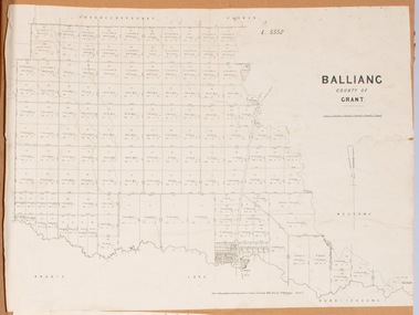
Map, Balliang Parish Map, County of Grant c.1907
... Balliang Parish Map, County of Grant c.1907...A single page paper map showing parish plan map for Balliang. This parish area contains the localities of Balliang and Balliang East and is located south of the township of Bacchus Marsh. ...Bacchus Marsh & District Historical Society Lerderderg Library Main Street Bacchus Marsh Balliang Victoria Maps Balliang Parish Maps A single page paper map showing parish plan map for Balliang. ...A single page paper map showing parish plan map for Balliang. This parish area contains the localities of Balliang and Balliang East and is located south of the township of Bacchus Marsh. The map is pasted into a bound volume containing 76 maps or plans in total. High resolution digital image stored on BMDHS computer network. balliang victoria maps, balliang parish maps -
 Whitehorse Historical Society Inc.
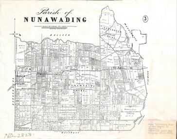
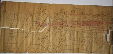
Map - Parish Map, Parish of Nunawading, 1892
... Parish Map...Plate 3 from the "Directory maps of the county of Bourke containing all the parishes, compiled to date from the most authentic municipal records and surveys, compiled and lithographed by G.S.B. ...A map copied from 'Directory maps - parishes and counties' dated 26 Nov 1892. ... of Nunawading Map Parish Map ...A map copied from 'Directory maps - parishes and counties' dated 26 Nov 1892. Compiled and lithographed by G.S. Bonney. The map includes roads, railway, stations, names of property owners. It has a scale [ca. 1:31,680] 40 chains to an 1 inch.A map copied from 'Directory maps - parishes and counties' dated 26 Nov 1892. Compiled and lithographed by G.S. Bonney. The map includes roads, railway, stations, names of property owners. It has a scale [ca. 1:31,680] 40 chains to an 1 inch.non-fictionA map copied from 'Directory maps - parishes and counties' dated 26 Nov 1892. Compiled and lithographed by G.S. Bonney. The map includes roads, railway, stations, names of property owners. It has a scale [ca. 1:31,680] 40 chains to an 1 inch.maps, parish of nunawading -
 Bacchus Marsh & District Historical Society
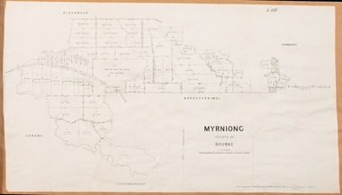
Map, Myrniong Parish Map 1904
... Myrniong Parish Map 1904...A cadastral map showing parish boundaries and land ownership. ...High resolution digital image stored on BMDHS computer network. Myrniong Parish Map 1904 Map Shire of Bacchus Marsh ...A single page paper map showing the map for the Parish of Myrniong in the County of Bourke. A cadastral map showing parish boundaries and land ownership. The map is pasted into a bound volume containing 76 maps or plans in total. High resolution digital image stored on BMDHS computer network. myrniong parish plan, myrniong parish maps, bacchus marsh region parish plans -
 Bacchus Marsh & District Historical Society
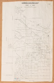
Map, Gorrockburkchap Parish Map, County of Grant c.1906
... Gorrockburkchap Parish Map, County of Grant c.1906...A cadastral map showing parish boundaries and land ownership The map is pasted into a bound volume containing 76 maps or plans in total. ...Gorrockburkchap Parish Map, County of Grant c.1906 Map Shire of Bacchus Marsh ...The parish of Gorrockburkchap (sometimes spelled Gorrockburkghap) lies to the west and south west of the township of Bacchus Marsh. The locality of Rowsley is situated within this parish area.A single page paper map showing the parish plan for Gorrockburkchap in the County of Grant. A cadastral map showing parish boundaries and land ownership The map is pasted into a bound volume containing 76 maps or plans in total. High resolution digital image stored on BMDHS computer network. gorrockburkchap parish maps, rowsley victoria maps, bacchus marsh region parish plans -
 Bacchus Marsh & District Historical Society
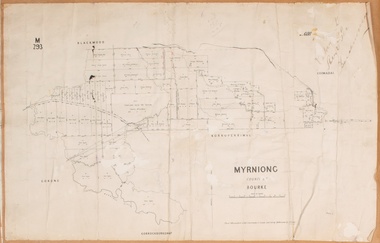
Map, Myrniong Parish Map, County of Bourke, 1882
... Myrniong Parish Map, County of Bourke, 1882...A cadastral map showing parish boundaries and land ownership. ...High resolution digital image stored on BMDHS computer network. Myrniong Parish Map, County of Bourke, 1882 Map Shire of Bacchus Marsh ...A single page paper map showing the map for the Parish of Myrniong in the County of Bourke. A cadastral map showing parish boundaries and land ownership. The map is pasted into a bound volume containing 76 maps or plans in total. High resolution digital image stored on BMDHS computer network. Photo-lithographed at the Department of Lands and Survey, Melbourne by J. Noone, 17.7.82myrniong parish plan, myrniong parish maps, bacchus marsh region parish plans -
 Bacchus Marsh & District Historical Society
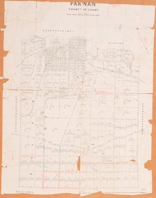
Map, Parwan Parish Map, County of Grant, 1909
... Parwan Parish Map, County of Grant, 1909...A cadastral map showing parish boundaries and land ownership. ...Bacchus Marsh & District Historical Society Lerderderg Library Main Street Bacchus Marsh Bacchus Marsh Region Parish Plans Parwan Parish Maps Parwan Parish Plan Photo-lithographed at the Department of Lands and Survey, Melbourne by T.F. ...A single page paper map showing the map for the Parish of Parwan in the County of Grant. A cadastral map showing parish boundaries and land ownership. The map is pasted into a bound volume containing 76 maps or plans in total. High resolution digital image stored on BMDHS computer network. Photo-lithographed at the Department of Lands and Survey, Melbourne by T.F. McGauran, 7.7.09. bacchus marsh region parish plans, parwan parish maps, parwan parish plan -
 Bacchus Marsh & District Historical Society
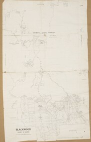
Map, Blackwood Parish Map, County of Bourke, 1892
... Blackwood Parish Map, County of Bourke, 1892...A cadastral map showing parish boundaries and land ownership. ...High resolution digital image stored on BMDHS computer network. Blackwood Parish Map, County of Bourke, 1892 Map Shire of Bacchus Marsh ...A single page paper map showing the map for the Parish of Blackwood in the County of Bourke. A cadastral map showing parish boundaries and land ownership. The map is pasted into a bound volume containing 76 maps or plans in total. High resolution digital image stored on BMDHS computer network. Photo-lithographed at the Department of Lands and Survey, Melbourne by T.F. McGauran 14.7.92bacchus marsh region parish plans, blackwood parish plan, blackwood parish maps -
 Bacchus Marsh & District Historical Society
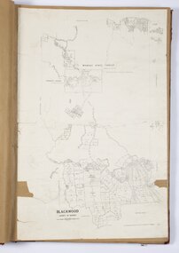
Map, Blackwood Parish Map, County of Bourke, 1905
... Blackwood Parish Map, County of Bourke, 1905...A cadastral map showing parish boundaries and land ownership. ...High resolution digital image stored on BMDHS computer network. Blackwood Parish Map, County of Bourke, 1905 Map Shire of Bacchus Marsh ...A single page paper map showing the map for the Parish of Blackwood in the County of Bourke. A cadastral map showing parish boundaries and land ownership. The map is pasted into a bound volume containing 76 maps or plans in total. High resolution digital image stored on BMDHS computer network. Photo-lithographed at the Department of Lands and Survey, Melbourne by T.F. McGauran 21.7.05bacchus marsh region parish plans, blackwood parish plan, blackwood parish maps -
 Bacchus Marsh & District Historical Society
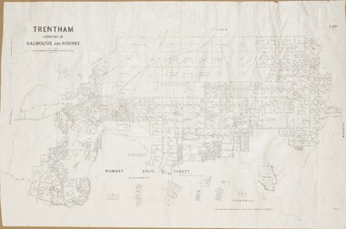
Map, Trentham Parish Map 1905 Copy 1
... Trentham Parish Map 1905 Copy 1...A cadastral map showing parish boundaries and land ownership. ...Bacchus Marsh & District Historical Society Lerderderg Library Main Street Bacchus Marsh Trentham Parish Maps Trentham Parish Plan Bacchus Marsh Region Parish Plans Photo-lithographed at the Department of Lands and Survey, Melbourne by T.F. ...A single page paper map showing the map for the Parish of Trentham in the Counties of Dalhousie and Bourke. A cadastral map showing parish boundaries and land ownership. The map is pasted into a bound volume containing 76 maps or plans in total. High resolution digital image stored on BMDHS computer network. Photo-lithographed at the Department of Lands and Survey, Melbourne by T.F. McGauran 22.3.05 trentham parish maps, trentham parish plan, bacchus marsh region parish plans -
 Bacchus Marsh & District Historical Society
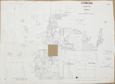
Map, Coimadai Parish Map, County of Bourke. Circa 1890s-1900s
... Coimadai Parish Map, County of Bourke. Circa 1890s-1900s....The cadastral Parish of Coimadai, a subdivision of the County of Bourke, lies directly north of the township of Bacchus Marsh. The date of this map...A cadastral map showing parish boundaries and land ownership. ... Plans Coimadai Parish Maps Coimadai Parish Plan Photo-lithographed at the Department of Lands and Survey, Melbourne by T.F. ...The cadastral Parish of Coimadai, a subdivision of the County of Bourke, lies directly north of the township of Bacchus Marsh. The date of this map is uncertain. T.F. McGauran the person who made a photo-lithographic copy of the map was in charge of photo-lithography at the Victorian Department of Lands and Survey in the late 19th century until about 1910.A single page paper map showing the map for the Parish of Coimadai in the County of Bourke. A cadastral map showing parish boundaries and land ownership. A rectangle shaped area is missing from the centre of the map due to a tear or deliberate excision. The map is pasted into a bound volume containing 76 maps or plans in total. High resolution digital image stored on BMDHS computer network. Photo-lithographed at the Department of Lands and Survey, Melbourne by T.F. McGauran 26.8.[??] NOTE. Photo litho from L.P showing temporary surveys and occupation of land prepared for departmental use onlybacchus marsh region parish plans, coimadai parish maps, coimadai parish plan -
Stawell Historical Society Inc
Map - Parish Map, Department of Lands and Survey, Ashens County of Borung 1941, 1941
... Parish Map...Stawell Historical Society Inc 46 Longfield St Stawell grampians Murtoa Lake Marma Survey Drawn and Reproduced at the department of Lands and Survey Melbourne 1.5.1941 Paper Brown Coloured Map Ashens County of Borung 1941 Map Parish Map Department of Lands and Survey ...Murtoa Lake MarmaPaper Brown Coloured MapDrawn and Reproduced at the department of Lands and Survey Melbourne 1.5.1941survey -
 Whitehorse Historical Society Inc.
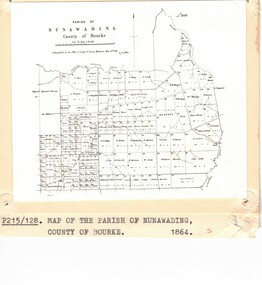
Photograph - Parish Map, Parish of Nunawading
... Parish Map...Black and white photo of map of the Parish of Nunawading, County of Bourke, 1864. ...Copy also at ND880, Map Drawer. Parish of Nunawading Photograph Parish Map ...Black and white photo of map of the Parish of Nunawading, County of Bourke, 1864. Copy also at ND880, Map Drawer.parish of nunawading, county of bourke, maps -
 Bendigo Historical Society Inc.
Plan - Parish Map of Sydney Flat
... Parish Map of Sydney Flat...There is red shading on Gully, Moon and New Chum lines. Plan Parish Map of Sydney Flat ...The New Moon Group of mines were located in the Sailors Gully/ Sydney Flat area. Sydney Flat was originally regard as part of Myers Creek, later Myers Flat it was changed to Sydney Flat when mining was established and was changed to Woodvale in the 1920s Sydney Flat Bushland Reserve is near-by. The area is north of Sailors Gully.Draftsman's drawing on cream coloured waxed paper with black print. SYDNEY FLAT is printed in the centre of a grid of streets with no names divided into sections there are names many of the sections including - J Dolman, G Wills, Gill, J Bayliss, Fracis Webb, T Downie, H Turner, J Hodgson, J Gordon, W Booth, J Shadbolt, J S Pearson, C Maroney, I Quin & Co, W Davey, J Kelly. Printed out of the grid is New Moon U and New Moon Cons. Added red handwriting are reef lines including - Christmas, Thistle, Carshalton, Napoleon, Gr nite, New Chum , Moon, Gully, Derby, Hustlers. There is red shading on Gully, Moon and New Chum lines.bendigo, gold, map, mine, margaret roberts collection, new moon mines, sailors gully, sydney flat -
 Bacchus Marsh & District Historical Society
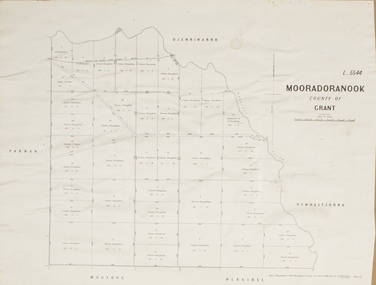
Map, Mooradoranook Parish Map, County of Grant
... Mooradoranook Parish Map, County of Grant...A single page paper map showing the map for the Parish of Mooradanook in the County of Grant. ...Bacchus Marsh & District Historical Society Lerderderg Library Main Street Bacchus Marsh Mooradoranook Parish Maps Mooradoranook Parish Plan Bacchus Marsh Region Parish Plans Photo lithographed at the Department of Lands and Survey Melbourne by T. ...A single page paper map showing the map for the Parish of Mooradanook in the County of Grant. Cadastral map showing land ownership. The map is pasted into a bound volume containing 76 maps or plans in total. High resolution digital image stored on BMDHS computer network. Photo lithographed at the Department of Lands and Survey Melbourne by T. F. McGauran, 27.11.06mooradoranook parish maps, mooradoranook parish plan, bacchus marsh region parish plans -
 Bacchus Marsh & District Historical Society
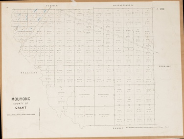
Map, Mouyong Parish Map, County of Grant
... Mouyong Parish Map, County of Grant...A single page paper map showing the map for the Parish of Mouyong in the County of Grant. ...High resolution digital image stored on BMDHS computer network. Mouyong Parish Map, County of Grant Map Shire of Bacchus Marsh ...A single page paper map showing the map for the Parish of Mouyong in the County of Grant. Cadastral map showing land ownership. The map is pasted into a bound volume containing 76 maps or plans in total. High resolution digital image stored on BMDHS computer network. Photo lithographed at the Department of Lands and Survey Melbourne by T. F. McGauran, 9. 4. 07mouyong parish plan, mouyong parish maps, bacchus marsh region parish plans -
 Bacchus Marsh & District Historical Society
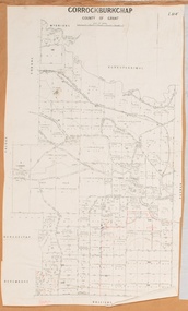
Map, Gorrockburkchap Parish Map, County of Grant
... Gorrockburkchap Parish Map, County of Grant...A single page paper map showing the parish plan for Gorrockburkchap in the County of Grant. ...Gorrockburkchap Parish Map, County of Grant Map Shire of Bacchus Marsh ...The parish of Gorrockburkchap (sometimes spelled Gorrockburkghap) lies to the west and south west of the township of Bacchus Marsh. The locality of Rowsley is situated within this parish area.A single page paper map showing the parish plan for Gorrockburkchap in the County of Grant. The map is pasted into a bound volume containing 76 maps or plans in total. High resolution digital image stored on BMDHS computer network. gorrockburkchap parish maps, rowsley victoria maps -
 Bacchus Marsh & District Historical Society
Map, Gorrockburkchap Parish Map, County of Grant c.1915
... Gorrockburkchap Parish Map, County of Grant c.1915...A single page paper map showing the parish plan for Gorrockburkchap in the County of Grant. ...Gorrockburkchap Parish Map, County of Grant c.1915 Map Shire of Bacchus Marsh ...The parish of Gorrockburkchap (sometimes spelled Gorrockburkghap) lies to the west and south west of the township of Bacchus Marsh. The locality of Rowsley is situated within this parish area.A single page paper map showing the parish plan for Gorrockburkchap in the County of Grant. The map is pasted into a bound volume containing 76 maps or plans in total. High resolution digital image stored on BMDHS computer network. gorrockburkchap parish maps, rowsley victoria maps -
 Federation University Historical Collection
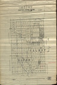
Plan - map, Ascot: Counties of Ripon and Talbot, 18/12/1920
... parish...map...Cadastral map showing parish boundaries and land ownership. ...Maps parishes located in Ascot area. Photo-Lithographed at the Dept. of Lands and Survey....Highlighted parish labelled, Mrs E.C.Sutherland. Maps parishes located in Ascot area. ...Cadastral map showing parish boundaries and land ownership. "L5270"Maps parishes located in Ascot area. Photo-Lithographed at the Dept. of Lands and Survey.Highlighted parish labelled, Mrs E.C.Sutherland.parish, map, ascot, counties, e. c. sutherland, a. cameron, sweeney, w. j. clarke, mount hollowback, tourello, burrumbeet, glendaruel, dowling forest, a. j. mullett, w. j. butson, 1920, william coghill, chatham, chatham family collection, mrs e.c.sutherland. -
 Kiewa Valley Historical Society
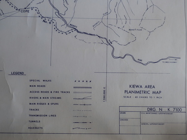
Maps - Kiewa Valley Parish Maps x3 and Kiewa Area Planimetric Map x1
... Maps - Kiewa Valley Parish Maps x3 and Kiewa Area Planimetric Map x1...Planimetric maps are 2 dimensional representations of the Earth's surface, showing the location and spatial arrangement of features such as roads, buildings, and bodies of water. The parish maps show the occupiers with leases or licences of the land. ...Wermatong, County of Bogong Parish Map 3. Mulllindolingong, County of Bogong Parish Map 4. ...Wermatong, County of Bogong Parish Map 3. Mulllindolingong, County of Bogong Parish Map 4. ...Planimetric maps are 2 dimensional representations of the Earth's surface, showing the location and spatial arrangement of features such as roads, buildings, and bodies of water. The parish maps show the occupiers with leases or licences of the land. These are updated by the Department of Lands regularly. The names of early settlers of the Kiewa Valley occupying land by lease or licence are shown. Many of these familie's descendants still live in the Kiewa Valley.1. Kiewa Area Planimetric Map (photo) 2. Wermatong, County of Bogong Parish Map 3. Mulllindolingong, County of Bogong Parish Map 4. Mullagong, County of Bogong Parish Map All black and white kiewa valley. parish maps. land owners -
Whitehorse Historical Society Inc.
Map, Map, Parish of Nunawading, 1850's
... Map, Parish of Nunawading...The basic Parish of Nunawading map has the 1882 railway added to it along with cemeteries and a State School. ...Downward 3.4.77 Map, Parish of Nunawading Map Melbourne Metropolitan Board of Works ...A basic map of the Parish of Nunawading to which additions have been made. Scale 70 chains:3.5 inchesA basic map of the Parish of Nunawading to which additions have been made. Scale 70 chains:3.5 inchesmaps, parish of nunawading -
 Bendigo Historical Society Inc.
Map - BENDIGO SHEET 2
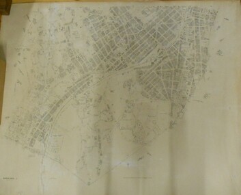
... ... Parish Map...Parish map showing the southern section of the City of Bendigo. ...History House 11 Mackenzie Street Bendigo goldfields MAP Bendigo city streets Parish Map City boundary H.J. Green Govt. Printer, Melbourne Parish map showing the southern section of the City of Bendigo. ...Parish map showing the southern section of the City of Bendigo. It shows the city boundary running along Murphy Street, Grave (Patterson) Street, and the turns at the south end of Macdougall Road, the corner of Alder and Aspinal Streets and the corner near the Specimen Hill - Marong roads intersectionH.J. Green Govt. Printer, Melbournemap, bendigo, city streets, parish map, city boundary -
 Greensborough Historical Society
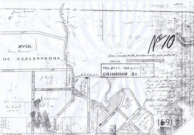
Plan, Parish Plan Map of Land North of Grimshaw Street, 11/12/1879
... Parish Plan Map of Land North of Grimshaw Street...Britnell, dated Dec. 11th 1879 Photocopy of part of Parish plan of land north of Grimshaw Street bounded by the Plenty River. Parish Plan Map of Land North of Grimshaw Street Plan ...Part of Parish plan of land north of Grimshaw Street bounded by the Plenty River. Includes annotation signed by John Scotland and J. W. Britnell, dated Dec. 11th 1879.Photocopy of part of Parish plan of land north of Grimshaw Street bounded by the Plenty River. Includes annotation signed by John Scotland and J. W. Britnell, dated Dec. 11th 1879greensborough, grimshaw street greensborough, jonah britnell, john scotland -
 Kiewa Valley Historical Society
Parish Maps - Kiewa Valley
... The Parish Maps show how the Counties were divided into allotments for buyers. ...Two copies of Parish Maps of the towns in the Kiewa Valley. ...They show how the Kiewa Valley was divided up into allotments for town dwellers and farmers and enables further research. kiewa valley. parish maps. land owners Two copies of Parish Maps of the towns in the Kiewa Valley. ...The Parish Maps show how the Counties were divided into allotments for buyers. On one the original owners are named and the sizes of their properties given. The reference numbers enable individuals research the history of the property. The other is on a smaller scale giving only the allotment numbers. The map with the names gives information on the early settlers of the Kiewa Valley. They show how the Kiewa Valley was divided up into allotments for town dwellers and farmers and enables further research.Two copies of Parish Maps of the towns in the Kiewa Valley. One gives the original owners and the other the reference numbers of the allotments.kiewa valley. parish maps. land owners