Showing 11374 items matching " plenty road"
-
 Melbourne Tram Museum
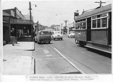
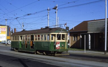
Photograph - W6 class 979 in Plenty Road, Melbourne & Metropolitan Tramways Board MMTB or VicRail or Ministry of Transport, 21/12/1956
... W6 class 979 in Plenty Road......Plenty Road...Photograph shows the side of W6 class car 979 in Plenty Road approaching the Bell Street intersection with sliding doors open and carrying passengers. ...Typed note attached to front reads: "Plenty Road, East Preston at Bell Street shunt, 1315 Hours, 21-12-1956" Hand written note on rear in pencil reads: "Plenty Road, East Preston at Bell Street shunt. ...Yields information about tram and vehicle traffic in Plenty Road Preston in 1956. official M&MTB photograph W6 class 979 Plenty Road Bell Street sliding doors panel damage crossover shunt Marshalite traffic signals East Preston Tram Depot Hight Street Smith Street Bourke Street Typed note attached to front reads: "Plenty Road, East Preston at Bell Street shunt, 1315 Hours, 21-12-1956" Hand written note on rear in pencil reads: "Plenty Road, East Preston at Bell Street shunt. ...Photograph shows the side of W6 class car 979 in Plenty Road approaching the Bell Street intersection with sliding doors open and carrying passengers. This car entered service in 1955 but has minor panel damage on its front left side below the saloon windows. In front of the tram is a crossover/shunt and several motor vehicles waiting in traffic and parked at the kerb next to shops. Among the parked vehicles are passengers waiting for the tram. The Bell Street intersection is controlled by Marshalite ‘clock-face’ traffic signals that were designed and built in Melbourne from the 1930s and used at many intersections until the late 1960s. Beyond the intersection on the left but out of sight is the new East Preston Tram Depot opened in 1955 when this electric line in Plenty Road was extended to the city via High Street, Smith Street and Bourke Street. This photograph is an official M&MTB photograph.Yields information about tram and vehicle traffic in Plenty Road Preston in 1956. Black and white photographs with typed note attached below and pencil note and stamp on rear. Typed note attached to front reads: "Plenty Road, East Preston at Bell Street shunt, 1315 Hours, 21-12-1956" Hand written note on rear in pencil reads: "Plenty Road, East Preston at Bell Street shunt. Lookimng north. Vehicles parked at shunt. 1315 Hours, 21-12-1956" Stamp reads: "Melbourne & Metropolitan Tramways Board P25/1/112" official m&mtb photograph, w6 class, 979, plenty road, bell street, sliding doors, panel damage, crossover, shunt, marshalite traffic signals, east preston tram depot, hight street, smith street, bourke street -
 Melbourne Tram Museum
Photograph - Fitzroy, Northcote & Preston Tramways Trust car number 1 in Plenty Road, early 1920s
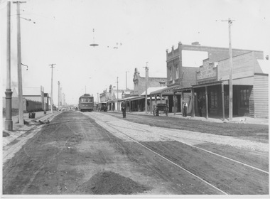
... Fitzroy, Northcote & Preston Tramways Trust car number 1 in Plenty Road......Plenty Road...Photograph of Fitzroy, Northcote & Preston Tramways Trust (FNPTT) R class tramcar No.1 northbound on single track in Plenty Road, Preston approaching a double track loop south of Bell Street. ...Melbourne Tram Museum 8 Wallen Road Hawthorn melbourne Photograph of Fitzroy, Northcote & Preston Tramways Trust (FNPTT) R class tramcar No.1 northbound on single track in Plenty Road, Preston approaching a double track loop south of Bell Street. ...Photograph of Fitzroy, Northcote & Preston Tramways Trust (FNPTT) R class tramcar No.1 northbound on single track in Plenty Road, Preston approaching a double track loop south of Bell Street. The photograph looks southward showing an unsealed road surface with a few horse drawn carts, span poles and overhead wires, tramways overhead light above loop turnout and low density shop fronts. While this tramcar and track were constructed for the FNPTT, the line was only operated by the Melbourne and Metropolitan Tramways Board from 1920. This car would soon be renumbered 151 and relocated to other lines Melbourne.Yields information about commencement of the Preston tram line and the Fitzroy, Northcote & Preston Tramways Trust. Black and white photograph with nothing on rearfnptt, r class, plenty road, preston, span poles, track loop, melbourne and metropolitan tramways board, fnptt number 1, tram number 151 -
 Greensborough Historical Society
Slide - Photograph, John Ramsdale, Bluestone Church on Plenty Road Mill Park: Slide 30, 1990s
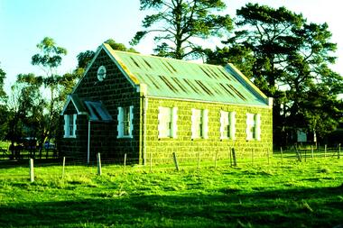
... Bluestone Church on Plenty Road Mill Park: Slide 30...plenty road mill park...Photograph shows a bluestone church on Plenty Road Mill Park....Greensborough Historical Society 34A Glenauburn Road Lower Plenty Lower Plenty melbourne Photograph shows a bluestone church on Plenty Road Mill Park. ...Photograph shows a bluestone church on Plenty Road Mill Park.Part of the John Ramsdale collection of slides and audio visual material.Colour photograph scanned from slide.No maker's marks. No caption on slide.plenty road mill park, bluestone church -
 Greensborough Historical Society
Slide - Photograph, John Ramsdale, Near Plenty Road South Morang: Slide 53, 1990s
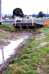
... Near Plenty Road South Morang: Slide 53...plenty road south morang...Photograph shows drain and culvert near Plenty Road South Morang....Greensborough Historical Society 34A Glenauburn Road Lower Plenty Lower Plenty melbourne Photograph shows drain and culvert near Plenty Road South Morang. ...Photograph shows drain and culvert near Plenty Road South Morang.Part of the John Ramsdale collection of slides and audio visual material.Colour photograph scanned from slide.No maker's marks. No caption on slide.plenty road south morang -
![Newspaper - Newspaper Clipping - Digital Image, The Whittlesea Post, Kentucky Fried Chicken [Plenty Road Bundoora 1988], 25/10/1988](/media/collectors/4f729f5697f83e03086015b8/items/6744fc640d508cb167f8beca/item-media/6744fc9a0d508cb167f8c76d/item-fit-380x285.jpg?cb=6) Greensborough Historical Society
Greensborough Historical SocietyNewspaper - Newspaper Clipping - Digital Image, The Whittlesea Post, Kentucky Fried Chicken [Plenty Road Bundoora 1988], 25/10/1988
... Kentucky Fried Chicken [Plenty Road Bundoora 1988]......plenty road bundoora...Kentucky Fried Chicken opened its store in Plenty Road Bundoora in 1988....Greensborough Historical Society 34A Glenauburn Road Lower Plenty Lower Plenty melbourne Kentucky Fried Chicken opened its store in Plenty Road Bundoora in 1988. kentucky fried chicken kfc bundoora plenty road bundoora local businesses fast food Digital copy of newspaper article Kentucky Fried Chicken [Plenty Road Bundoora 1988] Newspaper Newspaper Clipping - Digital Image The Whittlesea Post ...Kentucky Fried Chicken opened its store in Plenty Road Bundoora in 1988.Digital copy of newspaper articlekentucky fried chicken, kfc bundoora, plenty road bundoora, local businesses, fast food -
 Greensborough Historical Society
Slide - Photograph, John Ramsdale, Plenty Road: Slide 13, 1990s
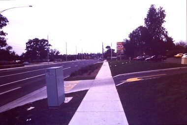
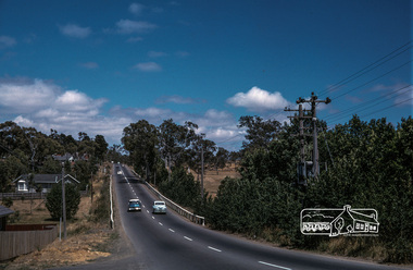
... Plenty Road: Slide 13...plenty road bundoora...Photograph shows a 3 lane road with Hungry Jacks sign - Plenty Road Bundoora....Greensborough Historical Society 34A Glenauburn Road Lower Plenty Lower Plenty melbourne Photograph shows a 3 lane road with Hungry Jacks sign - Plenty Road Bundoora. ...Photograph shows a 3 lane road with Hungry Jacks sign - Plenty Road Bundoora.Part of the John Ramsdale collection of slides and audio visual material.Colour photograph scanned from slide.No maker's marks. No caption on slide.plenty road bundoora -
 Greensborough Historical Society
Slide - Photograph, John Ramsdale, Plenty Road near Parade College: Slide 29, 1990s
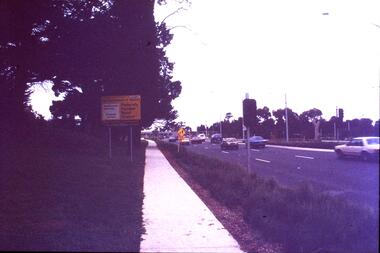
... Plenty Road near Parade College: Slide 29...plenty road bundoora...Photograph shows a 3-lane road with "Federally funded" sign This is Plenty Road Bundoora, near Parade college....Greensborough Historical Society 34A Glenauburn Road Lower Plenty Lower Plenty melbourne Photograph shows a 3-lane road with "Federally funded" sign This is Plenty Road Bundoora, near Parade college. ...Photograph shows a 3-lane road with "Federally funded" sign This is Plenty Road Bundoora, near Parade college.Part of the John Ramsdale collection of slides and audio visual material.Colour photograph scanned from slide.No caption. Printed maker's mark on slide "Kodak Kodachrome Slide"plenty road bundoora, parade college -
 Greensborough Historical Society
Slide - Photograph, John Ramsdale, Plenty Road and urban creep: Slide 28, 1990s
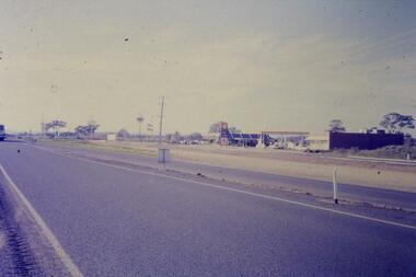
... Plenty Road and urban creep: Slide 28...plenty road mill park...Photograph shows Plenty Road Mill Park with Shell petrol station and Macdonalds, showing the urban expansion in this area....Greensborough Historical Society 34A Glenauburn Road Lower Plenty Lower Plenty melbourne Photograph shows Plenty Road Mill Park with Shell petrol station and Macdonalds, showing the urban expansion in this area. ...Photograph shows Plenty Road Mill Park with Shell petrol station and Macdonalds, showing the urban expansion in this area.Part of the John Ramsdale collection of slides and audio visual material.Colour photograph scanned from slide.No maker's marks. No caption on slide.plenty road mill park, urbanisation -
 Melbourne Tram Museum
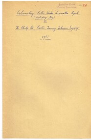
Document, Victorian Parliament, "The Plenty Road, Preston, Tramway Extension Inquiry", 1967
... "The Plenty Road, Preston, Tramway Extension Inquiry"......Plenty Road...Report by the Victorian Parliamentary Public Works Committee on "The Plenty Road, Preston, Tramway Extension Inquiry" - 1967. ..."The Plenty Road, Preston, Tramway Extension Inquiry" Document Victorian Parliament ...Report by the Victorian Parliamentary Public Works Committee on "The Plenty Road, Preston, Tramway Extension Inquiry" - 1967. The inquiry examined the MMTB's proposal to extend the East Preston line 0.7miles or 1.3km. The Committee took evidence from the MMTB, bus operators, the Victorian Railways, residents, La Trobe University, Preston City Council and others. The Committee recommended against the proposal. The report lists those members of Parliament involved. The line was subsequently extended by 1.2 kilometres from Tyler Street to Boldrewood Parade during 1983 and subsequently to Bundoora. Demonstrates the method of holding parliamentary inquiries into new tram lines.Document - report - 9 pages stapled in top left-hand corner, printed with a spirit duplicator.tramways, parliament, new lines, east preston, inquiries, bundoora, plenty road -
 Eltham District Historical Society Inc
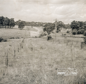
Photograph, Looking east from the northern side of Lower Plenty Road (opposite Bannockburn Road) as it crosses the Watsonia Drain, Viewbank, c.1965, 1965c
... Looking east from the northern side of Lower Plenty Road (opposite Bannockburn Road) as it crosses the Watsonia Drain, Viewbank, c.1965......Lower Plenty Hotel...Road...In the foreground a bulldozer can be seen commencing roadworks for the re-alignment of Lower Plenty Road for the new Lower Plenty Bridge crossing....Heidelberg Golf Club Lower Plenty Lower Plenty Hotel Road construction Viewbank Watsonia Drain Medium format 120 6x6 black and white negative film, 1 frame Looking east from the northern side of Lower Plenty Road (opposite Bannockburn Road) as it crosses the Watsonia Drain, Viewbank, c.1965 Photograph ...Transmission power lines visible in distance behind the Lower Plenty Hotel (in centre upper) and parts of Heidelberg Golf Club. In the foreground a bulldozer can be seen commencing roadworks for the re-alignment of Lower Plenty Road for the new Lower Plenty Bridge crossing.Medium format 120 6x6 black and white negative film, 1 frameheidelberg golf club, lower plenty, lower plenty hotel, road construction, viewbank, watsonia drain -
 Eltham District Historical Society Inc
Photograph, Fred Mitchell, Lower Plenty Road, Yallambie, 1968, 1968
... Lower Plenty Road, Yallambie, 1968......Lower Plenty Road...Immediately to left is Broadlea Crescent. fred mitchell collection 1968 Broadlea crescent Lower Plenty Road Watsonia Barracks yallambie Digital copy of colour photograph Lower Plenty Road, Yallambie, 1968 Photograph Fred Mitchell ...Road to Rosanna beside Watsonia Army Barracks. Immediately to left is Broadlea Crescent.Digital copy of colour photographfred mitchell collection, 1968, broadlea crescent, lower plenty road, watsonia barracks, yallambie -
 Melbourne Tram Museum
Slide, Keith Kings, 17/04/1968 12:00:00 AM
... ... Plenty Road...35mm Kodak white cardboard colour slide by Keith Kings of W2 642 leaving or shunting at East Preston Depot, Plenty Road. has the destination of East Preston Bell St, route 11 and a advert for Reddi. ...Keith Kings stamp and number "22-3", with details of exposure. "MMTB W2 642, Plenty Road East Preston Depot - vent roof and drip rails. 17/4/1968..."MMTB W2 642, Plenty Road East Preston Depot - vent roof and drip rails. 17/4/1968 35mm Kodak white cardboard colour slide by Keith Kings of W2 642 leaving or shunting at East Preston Depot, Plenty Road. has the destination of East Preston Bell St, route 11 and a advert for Reddi. ...35mm Kodak white cardboard colour slide by Keith Kings of W2 642 leaving or shunting at East Preston Depot, Plenty Road. has the destination of East Preston Bell St, route 11 and a advert for Reddi. Photo 17/4/1968. See Inscription for a note re the roof.Keith Kings stamp and number "22-3", with details of exposure. "MMTB W2 642, Plenty Road East Preston Depot - vent roof and drip rails. 17/4/1968trams, tramways, w2 class, east preston depot, plenty road, route 11, tram 642 -
 Greensborough Historical Society
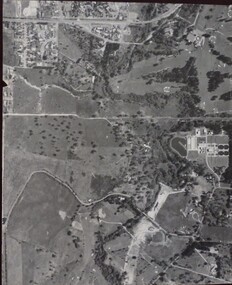
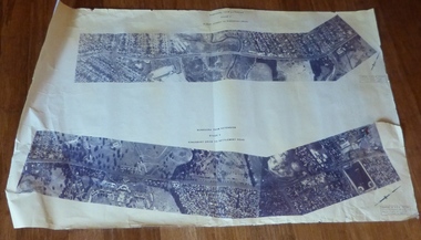
Aerial Photograph, Banyule Road / Lower Plenty Road, 1972c
... Banyule Road / Lower Plenty Road...Viewbank, Rosanna and Lower Plenty area, showing Lower Plenty Road and Banyule Road...Greensborough Historical Society 34A Glenauburn Road Lower Plenty Lower Plenty melbourne Viewbank, Rosanna and Lower Plenty area, showing Lower Plenty Road and Banyule Road viewbank Aerial survey photograph, black and white Banyule Road / Lower Plenty Road Aerial Photograph ...Viewbank, Rosanna and Lower Plenty area, showing Lower Plenty Road and Banyule RoadAerial survey photograph, black and whiteviewbank -
 Greensborough Historical Society
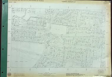
Map, Melbourne and Metropolitan Board of Works. Survey Division, MMBW, Yarra 2500 / 11.21. Bundoora, east of Plenty Road, 1979_01
... Bundoora, east of Plenty Road....Prominent streets include: Grimshaw Street, Settlement Road and Plenty Road. Includes Yulong Park....Bundoora, east of Plenty Road. Map Map Melbourne and Metropolitan Board of Works. ...Melbourne and Metropolitan Board of Works. Yarra 2500 [base map] 11-21. Bundoora, east of Plenty Road. Parish of Keelbundoora 2856, Municipalities of Diamond Valley 257, Preston 225 and Whittlesea 239. Prominent streets include: Grimshaw Street, Settlement Road and Plenty Road. Includes Yulong Park.MMBW Map in 1:2500 [scale] series. Cream parchment with green tape reinforcing on edges and punched holes on left edge.mmbw, melbourne and metropolitan board of works, shire of diamond valley, bundoora - maps -
 Melbourne Tram Museum
Document - Report, Parliamentary Public Works Committee, "Parliamentary Public Works Committee Report Plenty Road, Preston, Tramway Extension Enquiry, 1967
... "Parliamentary Public Works Committee Report Plenty Road, Preston, Tramway Extension Enquiry...Report contained within a light brown card folder, containing a photocopy of report titled "Parliamentary Public Works Committee Report (including map) on The Plenty Road, Preston, Tramway Extension Enquiry - 1967". ..."Parliamentary Public Works Committee Report Plenty Road, Preston, Tramway Extension Enquiry Document Report Parliamentary Public Works Committee ...Report contained within a light brown card folder, containing a photocopy of report titled "Parliamentary Public Works Committee Report (including map) on The Plenty Road, Preston, Tramway Extension Enquiry - 1967". Report stapled in top right hand corner, 15 pages examining the extension of the East Preston route to Bolderwood Parade. Map shows extension proposed, bus routes, railway lines, streets - folded into 4.AETA stamp on front and inside sheet and "4E6" in ink on front cover. AETA stamp on the bottom right hand corner of the map.trams, tramways, east preston, new tramway, bolderwood parade, proposals -
 Eltham District Historical Society Inc
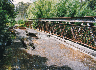
Negative - Photograph, J.A. McDonald, Eltham-Yarra Glen Road, Lower Plenty footbridge, Sep. 1955
... Eltham-Yarra Glen Road, Lower Plenty footbridge......Lower Plenty Road...West of the river the road was known as the Heidelberg-Eltham Road. The section from the Plenty River is now known as Lower Plenty Road which becomes Main Road. ...West of the river the road was known as the Heidelberg-Eltham Road. The section from the Plenty River is now known as Lower Plenty Road which becomes Main Road. ...The Eltham-Yarra Glen Road as designated originated at the Shire of Eltham boundary at the Plenty River. West of the river the road was known as the Heidelberg-Eltham Road. The section from the Plenty River is now known as Lower Plenty Road which becomes Main Road. The footbridge no longer exists but was originally sited to the south, adjacent to the old Lower Plenty Bridge, now part of the Plenty River Trail. Record of various Shire of Eltham infrastructure works undertaken during the period of 1952-1962 involving bridge and road reconstruction projects, sometimes with Eltham Shire Council Project Reference numbers quoted. It was during this period that a number of significant improvements were made to roads and new bridges constructed within the shire that remain in place as of present day (2022). In many situations, the photos provide a tangible visible record of infrastructure that existed throughout the early days of the Shire. The album was put together by or under the direction of the Shire Engineer, J.A. McDonald.1955-09, eltham-yarra glen road, lower plenty footbridge, lower plenty, lower plenty bridge, lower plenty road, main road, plenty river trail, bridge construction, infrastructure, shire of eltham -
 Eltham District Historical Society Inc
Negative - Photograph, J.A. McDonald, Eltham-Yarra Glen Road, Lower Plenty footbridge, Sep. 1955
... Eltham-Yarra Glen Road, Lower Plenty footbridge......Lower Plenty Road...West of the river the road was known as the Heidelberg-Eltham Road. The section from the Plenty River is now known as Lower Plenty Road which becomes Main Road. ...West of the river the road was known as the Heidelberg-Eltham Road. The section from the Plenty River is now known as Lower Plenty Road which becomes Main Road. ...Tony Carberry and J. Jolly The Eltham-Yarra Glen Road as designated originated at the Shire of Eltham boundary at the Plenty River. West of the river the road was known as the Heidelberg-Eltham Road. The section from the Plenty River is now known as Lower Plenty Road which becomes Main Road. The footbridge no longer exists but was originally sited to the south, adjacent to the old Lower Plenty Bridge, now part of the Plenty River Trail. Record of various Shire of Eltham infrastructure works undertaken during the period of 1952-1962 involving bridge and road reconstruction projects, sometimes with Eltham Shire Council Project Reference numbers quoted. It was during this period that a number of significant improvements were made to roads and new bridges constructed within the shire that remain in place as of present day (2022). In many situations, the photos provide a tangible visible record of infrastructure that existed throughout the early days of the Shire. The album was put together by or under the direction of the Shire Engineer, J.A. McDonald.1955-09, eltham-yarra glen road, lower plenty footbridge, j. jolly, lower plenty, lower plenty bridge, lower plenty road, main road, plenty river trail, tony carberry, bridge construction, infrastructure, shire of eltham -
 Eltham District Historical Society Inc
Slide, Looking southwest across to 184 Main Road, Lower Plenty during road widening works, 20 July 1970, 1970
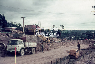
... Looking southwest across to 184 Main Road, Lower Plenty during road widening works, 20 July 1970...duplication, Lower Plenty, Main Road, Road construction...Road works to widen and duplicate Main Road at Lower Plenty from top of hill near Grand Boulevard, Montmorency to shire border at Lower Plenty bridge...Eltham District Historical Society Inc 728 Main Rd Eltham melbourne Road works to widen and duplicate Main Road at Lower Plenty from top of hill near Grand Boulevard, Montmorency to shire border at Lower Plenty bridge duplication, Lower Plenty, Main Road, Road construction 35 mm colour positive transparency Mount - Agfacolor Service (Blue) Looking southwest across to 184 Main Road, Lower Plenty during road widening works, 20 July 1970 Slide ...Road works to widen and duplicate Main Road at Lower Plenty from top of hill near Grand Boulevard, Montmorency to shire border at Lower Plenty bridge35 mm colour positive transparency Mount - Agfacolor Service (Blue)duplication, lower plenty, main road, road construction -
 Eltham District Historical Society Inc
Photograph, Doug Orford, Bridge across Plenty River, Main Road, Lower Plenty, 1991, 1991
... Bridge across Plenty River, Main Road, Lower Plenty, 1991...plenty...main road...Eltham District Historical Society Inc 728 Main Rd Eltham melbourne From a collection of 35 photos taken by Doug Orford at 35 specific locations along the exact boundary of the then Shire of Eltham. bridges lower plenty main road plenty river Colour photograph Bridge across Plenty River, Main Road, Lower Plenty, 1991 Photograph Photograph Doug Orford ...From a collection of 35 photos taken by Doug Orford at 35 specific locations along the exact boundary of the then Shire of Eltham.Colour photographbridges, lower plenty, main road, plenty river -
 Eltham District Historical Society Inc
Photograph, Construction of new bridge over the Plenty River, Main Road, Lower Plenty, c.Aug. 1966
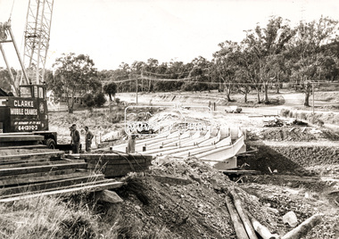
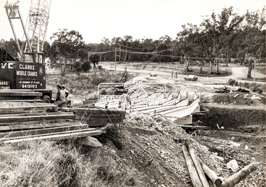
... Construction of new bridge over the Plenty River, Main Road, Lower Plenty...plenty...main road...Construction activity of a new Main Road bridge over the Plenty River at Lower Plenty in 1966. ...Local significance lower plenty main road plenty river bridge bridge construction civil engineering cranes mobile cranes Black and white print Construction of new bridge over the Plenty River, Main Road, Lower Plenty Photograph Photograph ...Construction activity of a new Main Road bridge over the Plenty River at Lower Plenty in 1966. The new bridge followed a realignment of the road and old Lower Plenty bridge remained in situ and is now part of the Plenty River Trail. Includes structural members, construction personnel, vehicles and a Clarke mobile crane.Local significanceBlack and white printlower plenty, main road, plenty river, bridge, bridge construction, civil engineering, cranes, mobile cranes -
 Eltham District Historical Society Inc
Photograph, Construction of new bridge over the Plenty River, Main Road, Lower Plenty, 13 July 1966
... Construction of new bridge over the Plenty River, Main Road, Lower Plenty...Plenty...Main Road...Construction activity of a new Main Road bridge over the Plenty River at Lower Plenty in 1966. ...Marking on back of photograph - Plenty River Bridge Main Road 1969 (sic)...Local significance Lower Plenty Main Road Plenty River Bridge bridge construction civil engineering Cranes mobile cranes Marking on back of photograph - Plenty River Bridge Main Road 1969 (sic) Black and white print Construction of new bridge over the Plenty River, Main Road, Lower Plenty Photograph Photograph ...Construction activity of a new Main Road bridge over the Plenty River at Lower Plenty in 1966. The new bridge followed a realignment of the road and old Lower Plenty bridge remained in situ and is now part of the Plenty River Trail. Includes structural members, construction personnel, vehicles and a Clarke mobile crane. Published Diamind Valley News, Tuesday, July 19, 1966, p1 Piecing Bridge Together A tall crane was used last Wednesday to lift and place in position the concrete and steel girders for the sub-structure of the new Lower Plenty Bridge. The picture shows the girders in position, looking towards the approach on the Lower Plenty side.Local significanceBlack and white printMarking on back of photograph - Plenty River Bridge Main Road 1969 (sic)lower plenty, main road, plenty river, bridge, bridge construction, civil engineering, cranes, mobile cranes -
 Eltham District Historical Society Inc
Negative - Photograph, J.A. McDonald, Eltham-Yarra Glen Road, Lower Plenty, c. July 1962
... Eltham-Yarra Glen Road, Lower Plenty......Lower Plenty...Road...Present-day Lower Plenty Road follows a revised alignment across a new bridge. ...Present-day Lower Plenty Road follows a revised alignment across a new bridge. ...View looking west across the Eltham-Yarra Glen Road approaching the Lower Plenty Bridge near turn-off for the Golf Club Hotel. Present-day Lower Plenty Road follows a revised alignment across a new bridge. The former bridge is now part of the Plenty River Trail and Edward Willis Court now follows this section of the original Eltham-Yarra Glen Road.. The Golf Club Hotel is gone and a new Lower Plenty Hotel was built slightly further up the hill.Record of various Shire of Eltham infrastructure works undertaken during the period of 1952-1962 involving bridge and road reconstruction projects, sometimes with Eltham Shire Council Project Reference numbers quoted. It was during this period that a number of significant improvements were made to roads and new bridges constructed within the shire that remain in place as of present day (2022). In many situations, the photos provide a tangible visible record of infrastructure that existed throughout the early days of the Shire. The album was put together by or under the direction of the Shire Engineer, J.A. McDonald.1962-07, shire of eltham, old eltham road, edward willis court, eltham-yarra glen road, golf club hotel, infrastructure, lower plenty, road construction -
 Eltham District Historical Society Inc
Photograph, Doug Orford, Lower Plenty Bridge, Old Eltham Road, Lower Plenty, 1998
... Lower Plenty Bridge, Old Eltham Road, Lower Plenty...plenty...main road...The bridge has since been restored and is now part of the Plenty River Trail. bridges lower plenty main road plenty river Old Eltham Road Two colour photograph prints 10 x 15 cm (2 copies) Lower Plenty Bridge, Old Eltham Road, Lower Plenty Photograph Photograph Doug Orford ...Originally the boundary between the former Shire of Eltham and the City of Heidelberg, a toll gate existed on the Eltham side. The bridge has since been restored and is now part of the Plenty River Trail.Two colour photograph prints 10 x 15 cm (2 copies)bridges, lower plenty, main road, plenty river, old eltham road -
 Melbourne Tram Museum
Drawing, Melbourne & Metropolitan Tramways Board (MMTB), Aerial photographs Bundoora Tram Extensions, Plenty Road – MMTB Drawings – 12/1979, Bundoora Extension – Metropolitan Transit Authority – 2/1983, John-Connell – Mott Hay and Anderson – Preliminary drawings for the Latrobe Modal Interchange – August 1984, 1979 to 1984
... Aerial photographs Bundoora Tram Extensions, Plenty Road – MMTB Drawings – 12/1979, Bundoora Extension – Metropolitan Transit Authority – 2/1983, John-Connell – Mott Hay and Anderson – Preliminary drawings for the Latrobe Modal Interchange – August 1984....Set of drawings for the MMTB Plenty Road extension in 1979, MTA extension to Bundoora in 1983 and the Latrobe Uni Modal Interchange - 1984. ...Set of drawings for the MMTB Plenty Road extension in 1979, MTA extension to Bundoora in 1983 and the Latrobe Uni Modal Interchange - 1984. ...Set of drawings for the MMTB Plenty Road extension in 1979, MTA extension to Bundoora in 1983 and the Latrobe Uni Modal Interchange - 1984. Large print – Aerial photographs Bundoora Tram Extensions Stage 2 – Albert St to Kingsbury Drive Stage 3 – Kingsbury Drive to Settlement Road Has been rolled, left hand edge damaged, right hand edge torn Compiled by the ROW Division – 2/1981. Has written on rear at right hand end “Bundoora Tram Extension – Official MMTB Plans” 760H x 1190W Plenty Road – MMTB Drawings – 12/1979 P15123 Tyler St to Walsal Avenue P15124 Walsal Ave t McColl St P15125 McColl St to Dorrington Avenue Bundoora Extension – Metropolitan Transit Authority – 2/1983 P15400 Dorrington Avenue to Barwon Avenue P15401 Barwon Avenue to Nicholson Ave P15402 Nicholson St to Barling Park P15403 Barling Park to Darebin Creek P15404 Darebin Creek to Scott Grove P15405 Scott Grove to Clunes Street P15406 Clunes St to Cash St P15408 Cash St to Bundoora Park P15409 Bundoora Park to Larundel Hospital P15410 At Larundel Hospital P15411 Larundel Hospital to Marne Court P15412 Marne Court to Cherrywood Court P15413 Cherrywood Court to Morwell Ave P15414 Morwell Ave to Grimshaw St P15415 Grimshaw St to Nickson Street P15416 Nickson St to McLeans Road John-Connell – Mott Hay and Anderson – Preliminary drawings for the Latrobe Modal Interchange – August 1984. 8094-A-20 Set Out Plan and Paving Details 8094-A-21 Elevations 8094-A-22 Sections 8094-A-23 Roof Plan and Stormwater Layout 8094-A-24 Canopy Details 8094-A-25 Toilet Block and Waiting Room 8094-A-28 Miscellaneous DetailsOn rear of aerial photograph sheet - at right hand end “Bundoora Tram Extension – Official MMTB Plans” in felt pen.trams, tramways, plenty rd, bundoora, latrobe university, mmtb, construction, mta -
 Eltham District Historical Society Inc
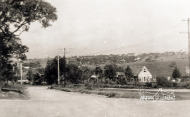
Photograph, Main Road, Lower Plenty
... Main Road, Lower Plenty...plenty...main road...Black and white photograph of Main Road, Lower Plenty looking west from Old Eltham Road...Date of photo is pre 1960s before duplication of Main Road. lower plenty main road old eltham road Black and white photograph of Main Road, Lower Plenty looking west from Old Eltham Road Main Road, Lower Plenty Photograph ...View is from Old Eltham Road looking northwest across Main Road to the De Bondy property and family home. Date of photo is pre 1960s before duplication of Main Road.Black and white photograph of Main Road, Lower Plenty looking west from Old Eltham Roadlower plenty, main road, old eltham road -
 Greensborough Historical Society
Advertising Card, Barry Plant Bundoora, 2015_08
... ...plenty road bundoora...1177 Plenty Road, Bundoora, Victoria, Australia...Greensborough Historical Society 34A Glenauburn Road Lower Plenty Lower Plenty melbourne Barry Plant Real Estate advertising free market appraisals. barry plant plenty road bundoora Coloured advertising, printed on 2 sides Barry Plant Bundoora Advertising Card ...Barry Plant Real Estate advertising free market appraisals. Coloured advertising, printed on 2 sidesbarry plant, plenty road bundoora -
![Advertisement, Whittlesea Post, Gilbertsons [butchers], Bundoora, 07/11/1989](/media/collectors/4f729f5697f83e03086015b8/items/5ae0483421ea6717e08936db/item-media/5ae0486d21ea6717e0897812/item-fit-380x285.jpg?cb=6) Greensborough Historical Society
Greensborough Historical SocietyAdvertisement, Whittlesea Post, Gilbertsons [butchers], Bundoora, 07/11/1989
... ...plenty road bundoora...Plenty Road, Bundoora...Greensborough Historical Society 34A Glenauburn Road Lower Plenty Lower Plenty melbourne Advertisement for Gilbertsons [butchers] of Bundoora. gilbertsons plenty road bundoora Newspaper advertisement. ...Advertisement for Gilbertsons [butchers] of Bundoora.Newspaper advertisement.gilbertsons, plenty road bundoora -
 Greensborough Historical Society
Photograph - Digital Image, Bundoora State School site, Redevelopment sign Bu1915, 01/10/2017
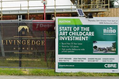
... ...plenty road bundoora...Plenty Road, Bundoora...The original school building was incorporated into the redevelopment to provide a modern child care facility. bundoora primary school bundoora state school plenty road bundoora childcare centre Digital copy of colour photograph Bundoora State School site, Redevelopment sign Bu1915 Photograph - Digital Image Marilyn Smith ...This photograph shows the Auction notice for the redeveloped site, formerly Bundoora State School. The original school building was incorporated into the redevelopment to provide a modern child care facility.Digital copy of colour photographbundoora primary school, bundoora state school, plenty road bundoora, childcare centre -
 Greensborough Historical Society
Photograph - Digital Image, Bundoora State School site. Redevelopment, new roof Bu1915, 01/10/2017
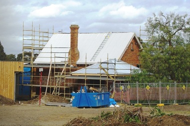
... ...plenty road bundoora...Plenty Road, Bundoora...The original school building was incorporated into the redevelopment to provide a modern child care facility. bundoora primary school bundoora state school plenty road bundoora childcare centre Digital copy of 5 colour photographs Bundoora State School site. ...This photograph shows a new roof being added to the redevelopment of the former Bundoora State School. The original school building was incorporated into the redevelopment to provide a modern child care facility.Digital copy of 5 colour photographsbundoora primary school, bundoora state school, plenty road bundoora, childcare centre -
 Greensborough Historical Society
Photograph - Photograph (Copy), Anne Paul, Lot 2A Main Road Lower Plenty, 2007_05
... Lot 2A Main Road Lower Plenty...plenty...main road lower plenty...Three views of entry into Lot 2A Main Road Lower Plenty, now Edward Willis Drive....Greensborough Historical Society 34A Glenauburn Road Lower Plenty Lower Plenty melbourne Three views of entry into Lot 2A Main Road Lower Plenty, now Edward Willis Drive. lower plenty main road lower plenty edward willis drive lower plenty 3 colour photographs printed on paper, handwritten captions Lot 2A Main Road Lower Plenty Photograph Photograph (Copy) Anne Paul ...Three views of entry into Lot 2A Main Road Lower Plenty, now Edward Willis Drive.3 colour photographs printed on paper, handwritten captionslower plenty, main road lower plenty, edward willis drive lower plenty