Showing 70 items matching " public land auctions"
-
 Bendigo Historical Society Inc.
Document - LANDS OFFICE, REPORTS OF SALES BY PUBLIC AUCTION, 1864 - 1892
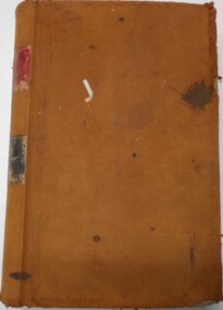
... ... public land auctions...On spine on red rectangle ' Land sales by public auction' written in gold. On bottom of spine 'Lands and Survey' written in gold on black. ...History House 11 Mackenzie Street Bendigo goldfields PLACE Bendigo Sandhurst crown land public land auctions land sales. Lands and Survey Dept. ...Document: buff leather hard covered journal. On spine on red rectangle ' Land sales by public auction' written in gold. On bottom of spine 'Lands and Survey' written in gold on black. On base of spine '4' printed in black. Pages contain details of sales of crown lands by public auction Act 25, Victoria 145. Alphabetical index of counties inside front cover. 443 numbered pages. LH side columns, number, county, parish, section, allotment sold, unsold, price. RH page - improvements, purchaser, residence, amount, later sales have printed notices pasted in. Dated 27 April 1864 to 7 October 1892.Lands and Survey Dept.place, bendigo, sandhurst, crown land, public land auctions, land sales. -
 Bendigo Historical Society Inc.
Document - LANDS OFFICE, REPORTS OF SALES BY PUBLIC AUCTION BENDIGO DISTRICT
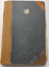
... land sold... public auction...Contains details of public auctions of land in Bendigo and district. Entries are in chronological order of sales with sale advertisement attached to page. ...Contains details of public auctions of land in Bendigo and district. Entries are in chronological order of sales with sale advertisement attached to page. ...Document: green hard cover book with buff spine and corners. Contains details of public auctions of land in Bendigo and district. Entries are in chronological order of sales with sale advertisement attached to page. Includes Manangatang, Boort, Rushworth, Maldon, Heathcote, Castlemaine, Sea Lake, Avoca.Lands Officeland sales, northern victoria, lands office, land surveyed, land sold, public auction, country victoria -
 Bendigo Historical Society Inc.
Document - H. A. & S. R. WILKINSON COLLECTION: CONTRACT OF SALE
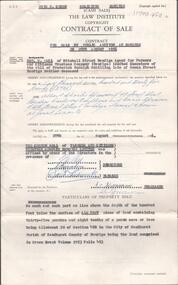
... Contract of sale of land by public auction dated 29th August, 1956 between Farmers and Citizens Trustees Company Bendigo executor of the will of F. .... & s.r wilkinson real estate Contract of sale of land by public auction dated 29th August, 1956 between Farmers and Citizens Trustees Company Bendigo executor of the will of F. ...Contract of sale of land by public auction dated 29th August, 1956 between Farmers and Citizens Trustees Company Bendigo executor of the will of F. R. Schilling deceased (vendor) and Mr. A. C. & Mrs. A. Sprawson (purchaser). Property: land that lies above the depth of 100 feet below the surface of all that land containing 35 perches and 8/10 of a perch being allotment 20 section 49B comprised in Crown Grant volume 2193 folio 493 situate No. 120 Rowan Street, Bendigo. Price: 2,725 pounds.organization, business, h.a. & s.r wilkinson real estate -
 Bendigo Historical Society Inc.
Document - H. A. & S. R. WILKINSON COLLECTION: CONTRACT OF SALE
... Contract of sale of land by public auction dated 17th March 1956 between Mr. .... & s.r wilkinson real estate Contract of sale of land by public auction dated 17th March 1956 between Mr. ...Contract of sale of land by public auction dated 17th March 1956 between Mr. Kevin Daniel Bourke (vendor) and Ms. Evelyn Mary Pook (purchaser). Solicitor for vendor: Hogan & Hogan, Bendigo. Solicitor for purchaser: Hyett, Willis & Hyett, Bendigo. Property: 112 Victoria Street, Eaglehawk being land firstly part of Crown allotment 11 section 17 Parish of Eaglehawk land described in certificate of title volume 2467 folio 304. Secondly part of Crown allotment 10 section 17 Parish of Eaglehawk, land coloured red on the plan hereon being part of land comprised in certificate of title volume 4416 folio 036. Price 1,100 pounds.organization, business, h.a. & s.r wilkinson real estate -
 Emerald Museum & Nobelius Heritage Park
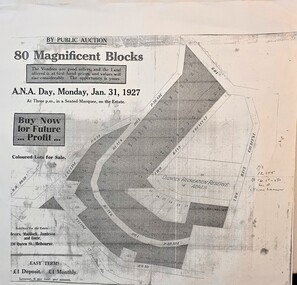
Map - Sales Flyer for 80 blocks of land in the region of Black Hill Parade, Selby on January 31, 1927, Public Auction, 80 blocks of land, Monday Jan.31, 1927, land adjacent to Black Hill Parade, Selby, c1927
... Public Auction, 80 blocks of land, Monday Jan.31, 1927, land adjacent to Black Hill Parade, Selby...By Public Auction/80 Magnificent Blocks/The Vendors are good sellers and the land offered is at first hand prices and values will rise considerably. ...Emerald Museum & Nobelius Heritage Park 5 Crichton Rd Emerald yarra-valley-and-the-dandenong-ranges Land sale by auction of property in Selby 1927 By Public Auction/80 Magnificent Blocks/The Vendors are good sellers and the land offered is at first hand prices and values will rise considerably. ...Image of Public Auction flyer on Jan31, 1927, 80 blocks in the vicinity of Black Hill Parade, Selby -
 Marysville & District Historical Society
THE TRIANGLE NEWS-VOL 36 NO 10-MARCH 27 2009
... auction...nilsson family...what's on when at the golf course...narby eggs...alexandra cinema...tarra warra museum of art...extension of arts victoria grant application closing dates...church notices...marysville & triangle artists...help rebuild our community...marysville temporary village underway...bruce ackerman...marysville golf & bowls club...e.s.a. land...andrew forrest...the dept. of human services...marque for memorial services & funerals...narbethong public...Marysville & District Historical Society 39 Darwin Street Marysville yarra-valley-and-the-dandenong-ranges marysville victoria australia st thomas' church buxton sotheby's charity auction nilsson family what's on when at the golf course narby eggs alexandra cinema tarra warra museum of art extension of arts victoria grant application closing dates church notices marysville & triangle artists help rebuild our community marysville temporary village underway bruce ackerman marysville golf & bowls club e.s.a. land andrew forrest the dept. of human services marque for memorial services & funerals narbethong public hall comittee free internet cafes storage containers advertisements spring of 1939 spring of 2008 THE TRIANGLE NEWS-VOL 36 NO 10-MARCH 27 2009 ...marysville, victoria, australia, st thomas' church buxton, sotheby's charity auction, nilsson family, what's on when at the golf course, narby eggs, alexandra cinema, tarra warra museum of art, extension of arts victoria grant application closing dates, church notices, marysville & triangle artists, help rebuild our community, marysville temporary village underway, bruce ackerman, marysville golf & bowls club, e.s.a. land, andrew forrest, the dept. of human services, marque for memorial services & funerals, narbethong public hall comittee, free internet cafes, storage containers, advertisements, spring of 1939, spring of 2008 -
Eltham District Historical Society Inc
Folder, Thomas Armstrong
... land on Kangaroo Ground, where he lived, until 1854, and then bought from Mr. John Dickson, a station on Yarra Flats, containing about 100,000, which at the expiration of two years was sold by public auction. ...land on Kangaroo Ground, where he lived, until 1854, and then bought from Mr. John Dickson, a station on Yarra Flats, containing about 100,000, which at the expiration of two years was sold by public auction. ...Armstrong, Thomas, J.P. Yarra Flats, was born in Roxburghshire, Scotland, in 1818, and in 1838, being then twenty years of age, emigrated to Australia, and engaged in taking contracts. In 1841, in conjunction with Mr. Wm. Bell he took out a squatting license and settled in what is now known as the township of Eltham. Mr Armstrong purchased land on Kangaroo Ground, where he lived, until 1854, and then bought from Mr. John Dickson, a station on Yarra Flats, containing about 100,000, which at the expiration of two years was sold by public auction. Messrs Armstrong and Bell then bought 14,000 acres where Mr Armstrong, now resides. He has been a member of the local council for twenty-eight years, and holds Her Majesty’s commission of the peace. His wife, Miss Diana Bell (daughter of his partner, Mr. Wm. Bell), whom he married in 1841, died fifteen years ago. from "Victoria and its Metropolis: Past and Present" written in 1888 by Alexander Sutherland. Chapter 19, "The Upper Yarra District" pages [402] - 415. Includes descriptions of some townships and short biographies of local residents. Page 405 Folder of information on Thomas Armstrong, JP, Kangaroo Groundthomas armstrong -
Glen Eira Historical Society
Document - Helenslea, Shelford CEGGS
... auction of 48 lots in the Helenslea Estate on 25/03/1916. The brochure references St Mary’s Church, shops on Glen Eira Road, Caulfield Grammar School, and existing homes in the vicinity and includes photographs of these localities. Reference is also made to available public transport and trees on the Estate. The brochure also includes an illustrated bird’s eye map of the Estate. Helenslea Estate Glen Eira Road St Kilda East Mansions Orrong Road Balaclava Road Caulfield Grammar School Fosberry Avenue St Mary’s Church Land ...Three copies of a photocopied fold out brochure relating to the auction of 48 lots in the Helenslea Estate on 25/03/1916. The brochure references St Mary’s Church, shops on Glen Eira Road, Caulfield Grammar School, and existing homes in the vicinity and includes photographs of these localities. Reference is also made to available public transport and trees on the Estate. The brochure also includes an illustrated bird’s eye map of the Estate.helenslea estate, glen eira road, st kilda east, mansions, orrong road, balaclava road, caulfield grammar school, fosberry avenue, st mary’s church, land subdivision, land brochures, residential development, auctions, caulfield north -
 Glen Eira Historical Society
Photograph - Glen Huntly Railway Station
... auction of Madden Estate featured in the Prahran Telegraph dated 20/09/1913. Glen Huntly Station Glenhuntly Station Railway Stations Railways Railway Gates Trains Glen Huntly Road Catherine Road Mernda Road Mermosa Road Railway Crossings Railway Lines Public Transport Madden Estate Land Sales Photograph Glen Huntly Railway Station ...This file contains one item. 1. Eleven Photographs of Glen Huntly Railway Station, five in black and white, and six in colour. They date from the earlier part of the 20th century as well as into the 1980’s. One black and white photograph has ‘first electric train?’ handwritten on the back. Another has been taken from an advertisement for the auction of Madden Estate featured in the Prahran Telegraph dated 20/09/1913.glen huntly station, glenhuntly station, railway stations, railways, railway gates, trains, glen huntly road, catherine road, mernda road, mermosa road, railway crossings, railway lines, public transport, madden estate, land sales -
 Bendigo Historical Society Inc.
Document - H. A. & S. R. WILKINSON COLLECTION: CONTRACT OF SALE
... public auction dated 13th September, 1950 between W. & M. G. Spedding (vendor) and D. A. Swift (purchaser). Property: 4 roomed weatherboard dwelling and front verandah situate on land, Grassy Flat, for removal. ...public auction dated 13th September, 1950 between W. & M. G. Spedding (vendor) and D. A. Swift (purchaser). Property: 4 roomed weatherboard dwelling and front verandah situate on land, Grassy Flat, for removal. ...Conditions of sale by public auction dated 13th September, 1950 between W. & M. G. Spedding (vendor) and D. A. Swift (purchaser). Property: 4 roomed weatherboard dwelling and front verandah situate on land, Grassy Flat, for removal. Price 445 pounds.organization, business, h.a. & s.r wilkinson real estate -
 Bendigo Historical Society Inc.
Document - H. A. & S. R. WILKINSON COLLECTION: CONTRACT OF SALE
... Conditions of sale by public auction dated 18th March, 1950 between T. Pratt (vendor) and W. & M. G. Spedding (purchaser). Property: land.... & s.r wilkinson real estate Conditions of sale by public auction dated 18th March, 1950 between T. Pratt (vendor) and W. & M. G. Spedding (purchaser). Property: land ...Conditions of sale by public auction dated 18th March, 1950 between T. Pratt (vendor) and W. & M. G. Spedding (purchaser). Property: land situate Grassy Flat, Bendigo being allotment 218B, Parish of Sandhurst County of Bendigo, containing 2 acres and 26.5 perches, land described in Crown grant volume 3127 folio 625277, together with 5 room weatherboard dwelling and all sundry outbuildings. Price: 800 pounds. Attached 1 hand written note.organization, business, h.a. & s.r wilkinson real estate -
 Bendigo Historical Society Inc.
Document - H. A. & S. R. WILKINSON COLLECTION: CONTRACT OF SALE
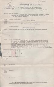
... Property: Allingham Street, Kangaroo Flat being Crown allotment 18 section D Parish of Mandurang land described in Conveyance No. 390 Book 324, also Crown allotment 18 section D Parish of Mandurang comprised in certificate of title volume 1712 folio 328. Price 550 pounds. Attached Authority and Conditions for Public Auction...Property: Allingham Street, Kangaroo Flat being Crown allotment 18 section D Parish of Mandurang land described in Conveyance No. 390 Book 324, also Crown allotment 18 section D Parish of Mandurang comprised in certificate of title volume 1712 folio 328. Price 550 pounds. Attached Authority and Conditions for Public Auction ...Contract of sale dated 17th October, 1964 between Mr. J. A. Guerin (vendor) and Mr. W. Shelton (purchaser). Solicitor for vendor: Watson, James & Rogers, RACV Bldg. View Street, Bendigo. Solicitor for purchaser: Watson, James & Rogers, View Point, Bendigo. Property: Allingham Street, Kangaroo Flat being Crown allotment 18 section D Parish of Mandurang land described in Conveyance No. 390 Book 324, also Crown allotment 18 section D Parish of Mandurang comprised in certificate of title volume 1712 folio 328. Price 550 pounds. Attached Authority and Conditions for Public Auction. written in pencil on the back M. W. Smith, Kirby Street 37025 was bidding for Shelton. .organization, business, h.a. & s.r wilkinson real estate -
 The Beechworth Burke Museum
Photograph - Lantern Slide, c1900
... auctioned later in the year, in addition to many smaller suburban lots. More lots were offered than sold, initially, but this represented conditions of sale requiring the total purchase cost up front which many people interested in purchasing could not afford, especially as land purchased for farming would accrue substantial additional costs for clearing and labour before becoming productive. Further lobbying activities and the election of parliamentary members sympathetic to the cause took place through the 1850s. Ovens Parliamentary Member, Daniel Cameron, was re-elected in 1856 on a platform of surveying the land for public...auctioned later in the year, in addition to many smaller suburban lots. More lots were offered than sold, initially, but this represented conditions of sale requiring the total purchase cost up front which many people interested in purchasing could not afford, especially as land purchased for farming would accrue substantial additional costs for clearing and labour before becoming productive. Further lobbying activities and the election of parliamentary members sympathetic to the cause took place through the 1850s. Ovens Parliamentary Member, Daniel Cameron, was re-elected in 1856 on a platform of surveying the land for public ...Miners from Snake Valley lobbied the Victorian Government in 1855 to make land available for sale for farming purposes as an alternative occupation and income for people who wished to stay in the region but move away from gold mining. A secondary motivation was to increase the supply of fresh produce and decrease prices of items that otherwise needed to be transported from Melbourne or other regions. Forty-three country lots were initially offered in the Three Mile area, ranging in size from two to ninety acres and costing from £1 to £3 per acre. An additional eighty-five country lots were auctioned later in the year, in addition to many smaller suburban lots. More lots were offered than sold, initially, but this represented conditions of sale requiring the total purchase cost up front which many people interested in purchasing could not afford, especially as land purchased for farming would accrue substantial additional costs for clearing and labour before becoming productive. Further lobbying activities and the election of parliamentary members sympathetic to the cause took place through the 1850s. Ovens Parliamentary Member, Daniel Cameron, was re-elected in 1856 on a platform of surveying the land for public selection with deferred payment options. Land reform remained an issue in the area through the 1850s and early 1860s, impacting broader decisions in the new State of Victoria relating to voting rights, use of Crown land and the farming of land that wasn't always suitable for the purpose. This photograph depicts Beechworth in approximately 1900, after several waves of land sales resulted in increasingly levels of development. Lantern slides, sometimes called 'magic lantern' slides, are glass plates on which an image has been secured for the purpose of projection. Glass slides were etched or hand-painted for this purpose from the Eighteenth Century but the process became more popular and accessible to the public with the development of photographic-emulsion slides used with a 'Magic Lantern' device in the mid-Nineteenth Century. Photographic lantern slides comprise a double-negative emulsion layer (forming a positive image) between thin glass plates that are bound together. A number of processes existed to form and bind the emulsion layer to the base plate, including the albumen, wet plate collodion, gelatine dry plate and woodburytype techniques. Lantern slides and magic lantern technologies are seen as foundational precursors to the development of modern photography and film-making techniques.This glass slide is significant because it provides insight into Beechworth's built environment and infrastructure in the early Twentieth Century, around the time of Australia's Federation. It is also an example of an early photographic and film-making technology in use in regional Victoria in the time period.Thin translucent sheet of glass with a square-edged image printed on the front and framed in a black backing. It is held together by metal strips to secure the edges of the slide.burke museum, beechworth, lantern slide, slide, glass slide, plate, burke museum collection, photograph, monochrome, indigo shire, north-east victoria, farming, squatters, miners, agriculture, land-clearing, land reform, daniel cameron, land sales, three mile, snake valley, tarrawingee -
 Halls Gap & Grampians Historical Society
Newspaper - Photocopy, C 1922
... Barnes, will offer by public auction on the property, the well known Tourist Accomodation (sic) House, "Killarney" together with 29 acres of freehold land, household furniture, stock, vehicles and sundries. ...Barnes, will offer by public auction on the property, the well known Tourist Accomodation (sic) House, "Killarney" together with 29 acres of freehold land, household furniture, stock, vehicles and sundries. ...Popular Grampian Mountains (The Blue Mountains of Victoria) Saturday, 1st April, 1922 at 12 o'clock On the property Halls Gap, 17 miles from Stawell Mitchell Bros & White under instructions from the Administrator of Lulu Barnes, deceased, and Mr A. H. Barnes, will offer by public auction on the property, the well known Tourist Accomodation (sic) House, "Killarney" together with 29 acres of freehold land, household furniture, stock, vehicles and sundries. The buildings consist main building of 8 rooms, kitchen, bathroom, vestibule, front and side passages, with verandah on front and side of building, also 3 roomed cottage with bathroom, 5 chalets containing 7 bedrooms, storeroom. wash house, water and gas laid on throughout. 4 cars, cow sheds, yards, pens, and sundry outbuildings. The furniture is all in first class order, consisting of beds and bedding for 30 visitors. Carl Ecko piano, splendid instrument; overmantle (sic) suites of furniture, extension tables, card tables, book case, sideboard, cupboards, dining table and chairs, linoleums, mats, wardrobes, duchess-chests, washstands and ware, curtains, pictures, ornaments, iron safe, kitchen tables, chairs, stove, separator, copper, large assortment of glassware, crockery, cutlery, kitchen utensils, and everything necessary for running the house. Rolling stock and C, consisting of 5 buggy and saddle ponies, 2 milch (sic) cows, 4 head young cattle, 3 pigs, 30 fowls, single seated hooded rubber tyred buggy, nearly new, 2 seated drag, carry seven, in good order; double seated buggy, gig, waggonette (sic), carry one ton; lorry, spring dray, double furrow disc plough, garden plow (sic), roller, garden roller. 6 saddles and bridles, almost new, large quantity of heavy and light harness, swing bars, chains, and numerous sundries. NOTE - The property will be offered with furniture, rolling stock & c., as a going concern at 12 o'clock sharp; and if not sold the furniture, stock, & C., will be offered TERMS AT SALE. MITCHELL BROS. & WHITE. AuctioneersTyped extract of advertisement for auction of Killarney from Stawell News 25-3-1922 later known as Grampians Housemedia, newspaper articles, guesthouses, killarney -
 Bendigo Historical Society Inc.
Legal record - FEATONBY Mrs Anne - Sale Note, Watson, James & Rogers, Rogers Collection, 10.02.1920
... ...Public Auction...Land...The firm is still located on Bull Street. https://rogersevery.com.au/about/ Sale note Sherriff Featonby Public Auction Land Sale Nicholas Kennedy Signatures. ...In the early 1980s the firm of Watson, James & Rogers merged with the partnership of Every & Every and became the iconic “Rogers & Every” as known today. The firm is still located on Bull Street. https://rogersevery.com.au/about/FEATONBY, Mrs Anne Sale note re Crown Allotment 4, Parish of Warriwitue County of Dalhousie. Cream coloured paper.Signatures.sale note, sherriff, featonby, public auction, land sale, nicholas kennedy -
 Bendigo Historical Society Inc.
Document - H.A. & S.R. WILKINSON COLLECTION: CONDITION OF SALE
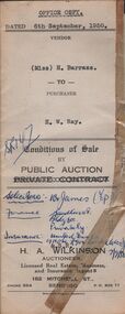
... public auction issued by H.A. Wilkinson and dated 6th September 1950 between miss H. Barrass (seller) and H. W. Ray (buyer) for land...public auction issued by H.A. Wilkinson and dated 6th September 1950 between miss H. Barrass (seller) and H. W. Ray (buyer) for land ...BHS CollectionConditions of sale by public auction issued by H.A. Wilkinson and dated 6th September 1950 between miss H. Barrass (seller) and H. W. Ray (buyer) for land situate No. 139 Queen Street Bendigo at present occupied by Mr. L.J. Lobb a tenant, being lot 1 on plan of subdivision made by Mr. A.E. Pritchard dated 13th August 1950 and being part of Crown allotment 10 section 90C, together with 5-roomed weatherboard dwelling and all sundry. Subject to existing weekly tenancy. Price 870 pounds.organization, business, h.a. & s.r wilkinson real estate -
 Bendigo Historical Society Inc.
Document - H.A. & S.R. WILKINSON COLLECTION: CONTRACT OF SALE
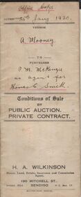
... Conditions of sale by public auction dated 25th January, 1930 between A. Mooney (seller) and P.M. McKenzie as agent for Thomas Smith for land situate Allingham Street, Golden Square being land described in certificate of registration as residence area no. 20503, together with all buildings on said land. .... & s.r wilkinson real estate Conditions of sale by public auction dated 25th January, 1930 between A. Mooney (seller) and P.M. McKenzie as agent for Thomas Smith for land situate Allingham Street, Golden Square being land described in certificate of registration as residence area no. 20503, together with all buildings on said land. ...This business was owned by father and son, Henry Archibald Wilkinson and Samuel Ronald "Ron" Wilkinson. Henry (1882-1954) was born in Shepparton and died in Bendigo. He was married to Grace Hovendon in 1908. Samuel Ronald "Ron" (1914-1995), Henry's son, was married to Florence Jean McKerlie in 1937.Conditions of sale by public auction dated 25th January, 1930 between A. Mooney (seller) and P.M. McKenzie as agent for Thomas Smith for land situate Allingham Street, Golden Square being land described in certificate of registration as residence area no. 20503, together with all buildings on said land. Price 26 pounds.organization, business, h.a. & s.r wilkinson real estate -
 Bendigo Historical Society Inc.
Document - H.A. & S.R. WILKINSON COLLECTION: CONTRACT OF SALE
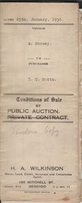
... Conditions of sale by public auction dated 25th January, 1930 between A. Mooney (seller) and T.C. Smith (buyer) for land situate Allingham Street, Golden Square, being described in certificate of registration as residence area No. 20503, together with all buildings on said land. .... & s.r wilkinson real estate Conditions of sale by public auction dated 25th January, 1930 between A. Mooney (seller) and T.C. Smith (buyer) for land situate Allingham Street, Golden Square, being described in certificate of registration as residence area No. 20503, together with all buildings on said land. ...This business was owned by father and son, Henry Archibald Wilkinson and Samuel Ronald "Ron" Wilkinson. Henry (1882-1954) was born in Shepparton and died in Bendigo. He was married to Grace Hovendon in 1908. Samuel Ronald "Ron" (1914-1995), Henry's son, was married to Florence Jean McKerlie in 1937.Conditions of sale by public auction dated 25th January, 1930 between A. Mooney (seller) and T.C. Smith (buyer) for land situate Allingham Street, Golden Square, being described in certificate of registration as residence area No. 20503, together with all buildings on said land. Price 26 pounds. Also account from The Bendigo Advertiser to H.A. Wilkinson for advertising dated 28 January, 1930 for 1 pound 10 shillings.organization, business, h.a. & s.r wilkinson real estate -
Bendigo Historical Society Inc.
Document - ALLOTMENTS SOLD BY PUBLIC AUCTION 1ST JUNE 1837 MELBOURNE
... Large copy of the first land auction in Melbourne on June the first 1837. Melbourne - Port Phillip, allotments sold by public auction with the name of the purchasers and of the prices. ...History House 11 Mackenzie Street Bendigo goldfields VICTORIA History land Large copy of the first land auction in Melbourne on June the first 1837. Melbourne - Port Phillip, allotments sold by public auction with the name of the purchasers and of the prices. ...Large copy of the first land auction in Melbourne on June the first 1837. Melbourne - Port Phillip, allotments sold by public auction with the name of the purchasers and of the prices. June 1st 1837.victoria, history, land -
 Bendigo Historical Society Inc.
Legal record - Register of Special Land Sales Castlemaine, 28/06/2007
... Land sales between 7/03/1862 to 20/04/1869, Castlemaine District on spine. Fine black handwritten entries. First page notes Report of a Sale on the 7th March 1862, in terms of Gazette notice of 7th July 1862. Sale conducted by Public Auction...Land sales between 7/03/1862 to 20/04/1869, Castlemaine District on spine. Fine black handwritten entries. First page notes Report of a Sale on the 7th March 1862, in terms of Gazette notice of 7th July 1862. Sale conducted by Public Auction ...Light brown suede leather cover with ornate embossed edging; and label on spines stating "3 and Register of Special Land Sales". Land sales between 7/03/1862 to 20/04/1869, Castlemaine District on spine. Fine black handwritten entries. First page notes Report of a Sale on the 7th March 1862, in terms of Gazette notice of 7th July 1862. Sale conducted by Public Auction by Thomas Couchman Esq. Acting D.S.land sales, castlemaine, 1860s -
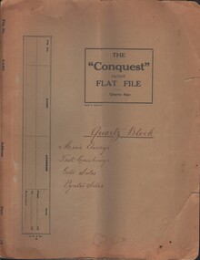 Bendigo Historical Society Inc.
Document - MCCOLL, RANKIN AND STANISTREET COLLECTION: QUARTZ BLOCK MINE TARADALE, 1935/41
... public auction, Power of Attorney 1937 Mary Symmons _ J. & E. Syndicate, agreement lease No. 8294 Castlemaine, list: Addresses of Cheque Receivers' ,suspension of Labour Covenants 1939, transfer of land to L. ...public auction, Power of Attorney 1937 Mary Symmons _ J. & E. Syndicate, agreement lease No. 8294 Castlemaine, list: Addresses of Cheque Receivers' ,suspension of Labour Covenants 1939, transfer of land to L. ...Documents - bundle of documents - agreement for mining lease transfer, agreement for electricity, 1939 'Sale by auction' booklet with items vale(sale price?) Bank Statement, correspondence re: public auction, Power of Attorney 1937 Mary Symmons _ J. & E. Syndicate, agreement lease No. 8294 Castlemaine, list: Addresses of Cheque Receivers' ,suspension of Labour Covenants 1939, transfer of land to L. C. Stuckey, letter from J. H. Curnow & Son re : Quartz Block Mine Auction 1939, folder contains assay reports etc and correspondence re: Auction.MCCOLL RANKIN AND STANISTREETorganization, business, gold mining - legal, mccoll rankin and stanistreet -
 Bendigo Historical Society Inc.
Document - LANDS OFFICE - SALE OF CROWN LAND BY AUCTION, 1892 - 1920
... public auctions of crown lands in fee simple at various locations in northern Victoria. Printed details of auctions pasted for each sale. LH page: lot, county, parish, section, allotment, sold, unsold, why not sold, upset price, sold for. RH page: value of improvements if any, name of purchaser, residence, deposit forfeited, total amount. Document LANDS OFFICE - SALE OF CROWN LAND ...Document: dark green hard cover journal with buff spine and corners. Contains details of public auctions of crown lands in fee simple at various locations in northern Victoria. Printed details of auctions pasted for each sale. LH page: lot, county, parish, section, allotment, sold, unsold, why not sold, upset price, sold for. RH page: value of improvements if any, name of purchaser, residence, deposit forfeited, total amount.Lands Officelands office, crown lands, auction, northern victoria -
 Bendigo Historical Society Inc.
Document - BUSINESS LICENSE PETITION
... The petitioners hoped that the land upon which they have erected their premises may be surveyed and put up for public auction and that the premises on the land are valued and allowed for....The petitioners hoped that the land upon which they have erected their premises may be surveyed and put up for public auction and that the premises on the land are valued and allowed for. ...Handwritten and typed copies of a Business License Petition. Petition is about storekeepers, etc. who have built their businesses on Crown Land. The petitioners hoped that the land upon which they have erected their premises may be surveyed and put up for public auction and that the premises on the land are valued and allowed for.document, names of bendigo pioneers, business license petition, business license petition, i hendry, major general macarthur -
 Bendigo Historical Society Inc.
Document - LANDS OFFICE: REPORTS OF LAND SALES BY AUCTION 1876 - 1891, 1876 - 1891
... Contains details of land sales by public auction Kerang, Swan Hill and Boort. m LH page ' Lot, County, Town or parish, section, allotment, sold, unsold, why not sold, upset price, sold per acre. ...Contains details of land sales by public auction Kerang, Swan Hill and Boort. m LH page ' Lot, County, Town or parish, section, allotment, sold, unsold, why not sold, upset price, sold per acre. ...Document: green hard cover journal, buff spine and corners. Contains details of land sales by public auction Kerang, Swan Hill and Boort. m LH page ' Lot, County, Town or parish, section, allotment, sold, unsold, why not sold, upset price, sold per acre. RH page: value of improvements, name of purchaser, residence, deposit forfeited, total amount. On spine in gold lettering ' report of sales by auction' underneath 'land sales' in black. No. 6 on top of spine, letter K on base.Lands Officeland sales, kerang, swan hill, boort, sandhurst, lands office -
 Bendigo Historical Society Inc.
Document - LANDS OFFICE: SANDHURST AND DISTRICT LAND SALES BY PUBLIC AUCTION 1855 - 1857
... LANDS OFFICE: SANDHURST AND DISTRICT LAND SALES BY PUBLIC AUCTION 1855 - 1857...land sales auctions Sandhurst Lands Office Document: booklet, marbled cardboard cover. Written on front ' Sale 1855 - ?7' Inside front cover £50 per acre - 6/3 per rood. £8 do. 1/- do, V1 do. -/1/2 do. 'E' ' from April 30th. 1855 to Jany. 27th. 1857' Contains blue pages with red columns. Copies of Crown Lands Sales listed in book, to right of copy, deposit, name of purchaser and total amount. White sticker on pocket Sandhurst Land Sales 22 January 1855 to 27 January 1857 Document LANDS OFFICE: SANDHURST AND DISTRICT LAND SALES BY PUBLIC ...Document: booklet, marbled cardboard cover. Written on front ' Sale 1855 - ?7' Inside front cover £50 per acre - 6/3 per rood. £8 do. 1/- do, V1 do. -/1/2 do. 'E' ' from April 30th. 1855 to Jany. 27th. 1857' Contains blue pages with red columns. Copies of Crown Lands Sales listed in book, to right of copy, deposit, name of purchaser and total amount. White sticker on pocket Sandhurst Land Sales 22 January 1855 to 27 January 1857Lands Officebendigo, land sales, lands office, crown land, land sales, auctions, sandhurst -
 Bendigo Historical Society Inc.
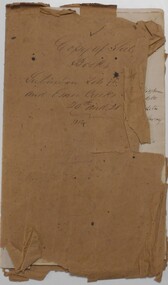
Document - LANDS OFFICE: SANDHURST AND DISTRICT LAND SALES BY PUBLIC AUCTION 1854
... LANDS OFFICE: SANDHURST AND DISTRICT LAND SALES BY PUBLIC AUCTION 1854 -...land sales auctions Document: booklet, heavy brown paper cover, written on cover ' copy of sale books, suburban lots in Sheep wash and Emu Creeks sold June 20th. And 21st. 1854. Contains newspaper cuttings with purchase amount and purchaser name. White sticker fixed to pocket: Book 2 Strathfieldsaye and Nerring Land Sales 20th. June 1854 to 21 June 1854 Document LANDS OFFICE: SANDHURST AND DISTRICT LAND SALES BY PUBLIC ...Document: booklet, heavy brown paper cover, written on cover ' copy of sale books, suburban lots in Sheep wash and Emu Creeks sold June 20th. And 21st. 1854. Contains newspaper cuttings with purchase amount and purchaser name. White sticker fixed to pocket: Book 2 Strathfieldsaye and Nerring Land Sales 20th. June 1854 to 21 June 1854lands office, bendigo, sandhurst, land sales, auctions -
 Bendigo Historical Society Inc.
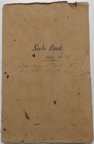
Document - LANDS OFFICE: SANDHURST AND DISTRICT LAND SALES BY PUBLIC AUCTION 1859 - 60
... LANDS OFFICE: SANDHURST AND DISTRICT LAND SALES BY PUBLIC AUCTION 1859 - 60...land auctions Lands Office Document: booklet, brown heavy paper cover bound secured with white cotton. Blue paper pages. On front cover ' Sale Book 1859, 60, 61. From August 16th. 1859 to Feb. 26 1861' Contains newspaper cuttings of crown land sales held in Sandhurst. Alongside cuttings are columns: price per acre, amount, purchasers. White sticker fixed to pocket: Book 7 Sandhurst Land Sales 16 August 1859 to March 1861 Document LANDS OFFICE: SANDHURST AND DISTRICT LAND SALES BY PUBLIC ...Document: booklet, brown heavy paper cover bound secured with white cotton. Blue paper pages. On front cover ' Sale Book 1859, 60, 61. From August 16th. 1859 to Feb. 26 1861' Contains newspaper cuttings of crown land sales held in Sandhurst. Alongside cuttings are columns: price per acre, amount, purchasers. White sticker fixed to pocket: Book 7 Sandhurst Land Sales 16 August 1859 to March 1861Lands Officebendigo, land sales 1859 - 60, lands office, sandhurst, crown land, auctions -
 Bendigo Historical Society Inc.
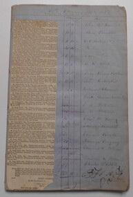
Document - LANDS OFFICE: SANDHURST AND DISTRICT LAND SALES BY PUBLIC AUCTION 1857, 1857 - 58
... LANDS OFFICE: SANDHURST AND DISTRICT LAND SALES BY PUBLIC AUCTION 1857...land auctions held in Sandhurst 1857/58. Book contains newspaper cutting listing town lots for sale. LH page: Total, balance, deposit, purchaser. LH page: same. White sticker fixed to front: Book 6 Sandhurst land Sales including outlying areas 30 January 1857 to 29 June 1859 Document LANDS OFFICE: SANDHURST AND DISTRICT LAND SALES BY PUBLIC AUCTION 1857 ...Document: blue lined pages listing crown land auctions held in Sandhurst 1857/58. Book contains newspaper cutting listing town lots for sale. LH page: Total, balance, deposit, purchaser. LH page: same. White sticker fixed to front: Book 6 Sandhurst land Sales including outlying areas 30 January 1857 to 29 June 1859bendigo, land sales -
 Bendigo Historical Society Inc.
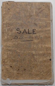
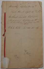
Document - LANDS OFFICE: SANDHURST AND DISTRICT LAND SALES BY PUBLIC AUCTION 1854
... LANDS OFFICE: SANDHURST AND DISTRICT LAND SALES BY PUBLIC AUCTION 1854 -...Document: booklet listing land sold by public auction in Sandhurst and surrounding district. ...History House 11 Mackenzie Street Bendigo goldfields land sales Land Office Sandhurst Bendigo crown land sales Document: booklet listing land sold by public auction in Sandhurst and surrounding district. ...Document: booklet listing land sold by public auction in Sandhurst and surrounding district. Written on front page in black ink: ' Huntly September 19, Eaglehawk Sept. 21st & 22nd. Sandhurst Town Lots Oct. 21st. Ravenswood Oct 24th & 25th. Sandhurst Bendigo Creek Epsom Oct. 25th. White Hills Nov. 14, 15, 16. White sticker fixed to pocket: Book 3 Sandhurst Land Sales, including outlying areas 19 September 1854 to 13 December 1854.land sales, land office, sandhurst, bendigo, crown land sales -
 Bendigo Historical Society Inc.
Document - LANDS OFFICE: REPORT OF LAND SALES BY AUCTION 1881 - 1895, 1881 - 1895
... Document: LANDS OFFICE: REPORT OF LAND SALES BY AUCTION 1881 - 1895 Green hard cover book with buff spine and corners. Contains reports of sale by public auctions of crown lands in Charlton, St. ...History House 11 Mackenzie Street Bendigo goldfields Land sales auctions Lands Office land surveyed land sold Lands Office Document: LANDS OFFICE: REPORT OF LAND SALES BY AUCTION 1881 - 1895 Green hard cover book with buff spine and corners. Contains reports of sale by public ...Document: LANDS OFFICE: REPORT OF LAND SALES BY AUCTION 1881 - 1895 Green hard cover book with buff spine and corners. Contains reports of sale by public auctions of crown lands in Charlton, St. Arnaud, Avoca, Donald, Wedderburn, Wycheproof.Lands Officeland sales, auctions, lands office, land surveyed, land sold