Showing 125691 items matching " roads"
-
 Mont De Lancey
Booklet, Department of Main Roads, Toll Roads and Bridges, 1981
... Toll Roads and Bridges......Roads...Early toll roads and bridge use in Australia from early settlement days to 1981....A small slim rectangular paperback brochure with a lithograph of the "New Toll Gate" on Parramatta Road, published in J.G. Austin's Sydney Views. ...Department of Main Roads...There are many photographs inside. Toll Roads and Bridges Booklet Department of Main Roads National Association of Australian State Road Authorities ...A brief history of tolls used throughout history, dating back around 1950 B.C. Early English and USA use is mentioned. Road and bridge tolls in Australia were collected for construction and maintenance of particular roads and bridges similar to their use in England. The clear photographs show the development in the this country up to 1981 when the brochure was published.A small slim rectangular paperback brochure with a lithograph of the "New Toll Gate" on Parramatta Road, published in J.G. Austin's Sydney Views. Green and white edging surrounds the picture with the title Toll Roads and Bridges printed in black lettering at the top right of the cover. On the back is a photograph of Toll cabins at the northern end of the Sydney Harbour Bridge showing automatic and manual toll booths with the symbol for NAASRA and National Association of Australian State Road Authorities printed in black and white at the bottom. Pp. 20. There are many photographs inside.non-fictionA brief history of tolls used throughout history, dating back around 1950 B.C. Early English and USA use is mentioned. Road and bridge tolls in Australia were collected for construction and maintenance of particular roads and bridges similar to their use in England. The clear photographs show the development in the this country up to 1981 when the brochure was published.road tolls, roads, bridges, history of tolls -
 Eltham District Historical Society Inc
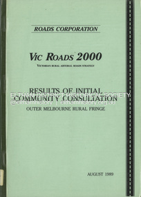
Book, Roads Corporation, Vic Roads 2000: results of intial community consultation, outer Melbourne rural fringe, August 1989
... Vic Roads 2000: results of intial community consultation, outer Melbourne rural fringe...Roads...Roads Corporation...Vic Roads 2000: results of intial community consultation, outer Melbourne rural fringe Book Roads Corporation ...This report presents a summary of the issues and needs communicated by community and road user groups, local government, industry and government department representatives, at two of a series of VICROADS Regional Workshops convened by the Roads Corporation, as the Vic Roads 2000 Victoria's Rural Arterial Strategy is developed. Includes three parts: Outer Metropolitan Regional Workshop Report, Outer Dandenong Regional Workshop Report and background paper - Outer Melbourne rural fringe regional economy and road travel demand.100p.non-fictionThis report presents a summary of the issues and needs communicated by community and road user groups, local government, industry and government department representatives, at two of a series of VICROADS Regional Workshops convened by the Roads Corporation, as the Vic Roads 2000 Victoria's Rural Arterial Strategy is developed. Includes three parts: Outer Metropolitan Regional Workshop Report, Outer Dandenong Regional Workshop Report and background paper - Outer Melbourne rural fringe regional economy and road travel demand.roads, vicroads -
 Greensborough Historical Society
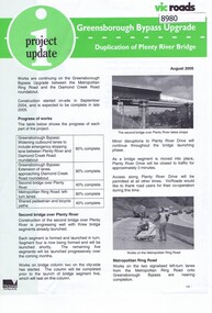
Newsletter, Vic Roads, Vic Roads , Greensborough Bypass Upgrade - Duplication of Plenty River Bridge, August 2005
... Vic Roads , Greensborough Bypass Upgrade - Duplication of Plenty River Bridge...Vic Roads Newsletter regarding the Greensborough Bypass Upgrade and duplication of the Plenty River Bridge....Vic Roads...Greensborough Historical Society 34A Glenauburn Road Lower Plenty Lower Plenty melbourne Vic Roads Newsletter regarding the Greensborough Bypass Upgrade and duplication of the Plenty River Bridge. greensborough bypass vicroads plenty ri plenty river bridge 2 page Newsletter with print and black & white photos Vic Roads , Greensborough Bypass Upgrade - Duplication of Plenty River Bridge Newsletter Newsletter Vic Roads ...Vic Roads Newsletter regarding the Greensborough Bypass Upgrade and duplication of the Plenty River Bridge.2 page Newsletter with print and black & white photosgreensborough bypass, vicroads, plenty ri, plenty river bridge -
 Surrey Hills Historical Society Collection
Photograph, Stand-pipe at the corner of Warrigal and Riversdale Roads, Surrey Hills, c1916, c1916
... Stand-pipe at the corner of Warrigal and Riversdale Roads, Surrey Hills, c1916...The original print had a text which was included in our copy print as follows: "EVEN IN 1916, WATER SUPPLIES FOR MANY SURREY HILLS FARMERS AND MARKET GARDENS STILL / CAME FROM THE STAND-PIPE AT THE WARRIGAL ROAD TRAM TERMINUS. PREVIOUSLY WATER WAS / PURCHASED FROM THE VILLAGE TANK AT THE CORNER OF WINDSOR CRESCENT AND UNION ROAD. / THE PRICE WAS 1/- FOR 400 GALLONS."...In the background is a building that may be a shop with wagons outside and further down the road is a tram....Corner of Warrigal and Riversdale Roads, Surrey Hills, Victoria...In the background is a building that may be a shop with wagons outside and further down the road is a tram. Stand-pipe at the corner of Warrigal and Riversdale Roads, Surrey Hills, c1916 Photograph Photograph ...This was part of an exhibition mounted by the Surrey Hills State Savings Bank in 1976. The original print had a text which was included in our copy print as follows: "EVEN IN 1916, WATER SUPPLIES FOR MANY SURREY HILLS FARMERS AND MARKET GARDENS STILL / CAME FROM THE STAND-PIPE AT THE WARRIGAL ROAD TRAM TERMINUS. PREVIOUSLY WATER WAS / PURCHASED FROM THE VILLAGE TANK AT THE CORNER OF WINDSOR CRESCENT AND UNION ROAD. / THE PRICE WAS 1/- FOR 400 GALLONS."Black and white photo of a horse and water cart in position at the stand-pipe. A man holds the horse's reins and 2 young boys are perched on the cart. In the background is a building that may be a shop with wagons outside and further down the road is a tram.horse-drawn vehicles, water supply, warrigal road, riversdale road, transport, surrey hills, standpipe -
 Ringwood and District Historical Society
Plans - Freeway, Country Roads Board, Victoria, Eastern Freeway Ringwood Section - Planning Report on Suggested Concepts Investigation (Country Roads Board) 1974, 1974
... Eastern Freeway Ringwood Section - Planning Report on Suggested Concepts Investigation (Country Roads Board) 1974...Country Roads Board, Victoria...Eastern Freeway Ringwood Section - Planning Report on Suggested Concepts Investigation (Country Roads Board) 1974 Plans - Freeway Country Roads Board, Victoria ...Report on suggested concepts investigation for freeway.Report on suggested concepts investigation for freeway. Buff coloured covers with brown printing. Bound with brown Spirex. pp. 39. -
 Surrey Hills Historical Society Collection
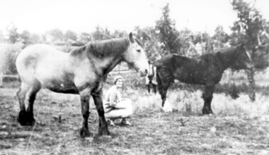
Photograph, Lloyd brothers’ horses near corner of Elgar & Whitehorse Roads, c1930
... Lloyd brothers’ horses near corner of Elgar & Whitehorse Roads, c1930...Lloyd Brothers butchers were located on the NW corner Whitehorse Road and Elgar Roads; previously the premises of Edward Tacey, butcher, established in 1888. ...Corner of Elgar & Whitehorse Roads, Surrey Hills, Victoria, Australia...Surrey Hills Historical Society Collection 190A Canterbury Road Canterbury melbourne Lloyd Brothers butchers were located on the NW corner Whitehorse Road and Elgar Roads; previously the premises of Edward Tacey, butcher, established in 1888. ...Lloyd Brothers butchers were located on the NW corner Whitehorse Road and Elgar Roads; previously the premises of Edward Tacey, butcher, established in 1888. There was an abattoir adjoining the premises. In 1901 the Box Hill Reporter contained a protest regarding the proposed extension of the abattoir. In 1907 it was claimed that the development of land in Mont Albert was hindered by the smells and operations of the abattoir. Lloyds also had a shop in Union Road Surrey Hills from 1920-1951, opposite the end of Windsor Crescent.A black and white photograph of a lady squatting in a paddock with two horses.lloyd brothers, butchers, tafe college, elgar road, whitehorse road, mont albert, box hill -
Stawell Historical Society Inc
Map, Roads Maintained by NGSC. Roads Maintained by Other Authorities, C 2020
... Roads Maintained by NGSC. Roads Maintained by Other Authorities.......Roads...Printed Colour map of Norther Grampians Shire, with roads marked in colour...Stawell Historical Society Inc 46 Longfield St Stawell grampians Shire Roads Transport Norther Grampians Shire COuncil. 1:200,000 Printed Colour map of Norther Grampians Shire, with roads marked in colour Roads Maintained by NGSC. ...Printed Colour map of Norther Grampians Shire, with roads marked in colourNorther Grampians Shire COuncil. 1:200,000shire, roads, transport -
 City of Kingston
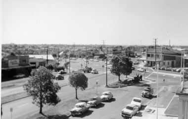
Photograph - Digital image, Black and white, Roads - Junction of Nepean Highway and South Road, c. 1950
... Roads - Junction of Nepean Highway and South Road...Shops in centre demolished for road widening in 1980's...Black and white image of Nepean Highway and South Road junction point of view from Kingston Town Hall...Printed in black text a round white sticker: 234 Handwritten in red ink 80% Yellow post it note written in blue ink: CHAP 7 234 / - Nepean Hwy + South Road...City of Kingston Parkdale Library 96 Parkers Road, Parkdale Parkdale Junction of Nepean Highway and South Road, Moorabbin - Moorabbin Hotel on right. ...Junction of Nepean Highway and South Road, Moorabbin - Moorabbin Hotel on right. Shops in centre demolished for road widening in 1980'sBlack and white image of Nepean Highway and South Road junction point of view from Kingston Town HallPrinted in black text a round white sticker: 234 Handwritten in red ink 80% Yellow post it note written in blue ink: CHAP 7 234 / - Nepean Hwy + South Roadnepean highway, south road, moorabbin, moorabbin hotel -
 Orbost & District Historical Society
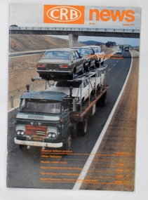
magazine, CRB News, August 1975
... It was succeeded by the Road Construction authority on 1 July 1983 and later merged with the Road Traffic Authority on July 1 1989 to form the Roads Corporation. ...A 19 pp magazine, titled CRB ( Country Roads Board) News. It is dated August 1976. ...Country Roads Board...It was succeeded by the Road Construction authority on 1 July 1983 and later merged with the Road Traffic Authority on July 1 1989 to form the Roads Corporation. ...The Country Roads Board was the government authority for the construction and maintenance of main roads in Victoria between 1913 and 1983. It was succeeded by the Road Construction authority on 1 July 1983 and later merged with the Road Traffic Authority on July 1 1989 to form the Roads Corporation. James Cameron, an Orbost farming pioneer and Member of the Legislative Assembly, fathered the Country Roads Board.This item is a useful research source on the Princes Highway, Gippsland.A 19 pp magazine, titled CRB ( Country Roads Board) News. It is dated August 1976. On the front cover is a coloured photograph of a truck carrying cars. In the background is a road bridge. It contains an article on the Princes Highway, Gippsland.magazine journal-crb-news princes-highway -
 Orbost & District Historical Society
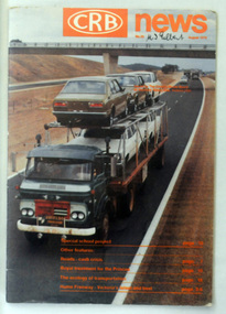
magazine, CRB News, August 1976
... At this time the use of the motor car accentuated the demands for better roads. As a result of these needs the Country Roads Act 1912 was proclaimed in 1913 providing for the establishment of the Country Roads Board as a central road authority with responsibility for those roads within the State considered to be main roads. the C.R.B. was responsible for the construction of roads and bridges including the Snowy River road bridges in Orbost. ...On the front cover the title is in orange print with No. 33 August 1976 above a coloured photo of a truck carrying two tiers of new vehicles along a main sealed road. It contains information and photos of the construction of the Snowy River road bridges....Country Roads Board...At this time the use of the motor car accentuated the demands for better roads. As a result of these needs the Country Roads Act 1912 was proclaimed in 1913 providing for the establishment of the Country Roads Board as a central road authority with responsibility for those roads within the State considered to be main roads. the C.R.B. was responsible for the construction of roads and bridges including the Snowy River road bridges in Orbost. ...By 1910 it had become apparent that there was a need for a central roads authority to take over responsibility from the Board of Lands and Works for the care and management of the main roads of the state of Victoria. Because there was no consistent and systematic policy for road maintenance Victorian roads were in a deplorable condition. At this time the use of the motor car accentuated the demands for better roads. As a result of these needs the Country Roads Act 1912 was proclaimed in 1913 providing for the establishment of the Country Roads Board as a central road authority with responsibility for those roads within the State considered to be main roads. the C.R.B. was responsible for the construction of roads and bridges including the Snowy River road bridges in Orbost. This was a major project involving not only a new bridge over the Snowy River (including Lochiel Lagoon), but other bridges over Ashby’s Gulch and Watt’s Gulch. These new bridges were opened in November 1976 with the unveiling of a plaque on the eastern end of the $2.4M Snowy River Bridge. (ref. May Leatch) This is a useful reference tool on the history of the construction of the Snowy River road bridges.A journal, titled "CRB News" . On the front cover the title is in orange print with No. 33 August 1976 above a coloured photo of a truck carrying two tiers of new vehicles along a main sealed road. It contains information and photos of the construction of the Snowy River road bridges.on front cover - handwritten in black - "M. I. Gilbert"crb-news country-roads-board snowy-river-road-bridges -
Marysville & District Historical Society
Document (item) - Report, Clement Wilks, Track to the River Jordan Gold Fields, 1864-1865
... A report by Mr Road Engineer Wilks on the construction of the Yarra Track in Victoria....A report by Mr Road Engineer Wilks on the construction of the Yarra Track in Victoria.......Department of Roads & Bridges...A report by Mr Road Engineer Wilks on the construction of the Yarra Track in Victoria. ...A report by Mr Road Engineer Wilks on the construction of the Yarra Track in Victoria.A report by Mr Road Engineer Wilks on the construction of the Yarra Track in Victoria. The Yarra Track is the former name of the gold fields road from Healesville to the Woods Point and Jordan Goldfields, in Victoria, Australia. By Authority: JOHN FERRES, Government Printer, Melbourneclement wilks, yarra track, marysville, victoria, wood's point, healesville, jordan gold fields -
 Greensborough Historical Society
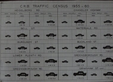
Diagram, C. R. B. Traffic Census 1955-1960, 07/06/1960
... The Country Roads Board, which had responsibility for major metropolitan roads, conducted a census of maximum hourly and daily traffic volumes recorded in 1955 and 1960 on 10 major roads in the Heidelberg and Greensborough areas....Country Roads Board...Country Roads Board...Traffic Census 1955-1960 Diagram Country Roads Board Country Roads Board ...The Country Roads Board, which had responsibility for major metropolitan roads, conducted a census of maximum hourly and daily traffic volumes recorded in 1955 and 1960 on 10 major roads in the Heidelberg and Greensborough areas.Black and white table G.M.H.traffic, heidelberg, greensborough, country roads board -
 Ballarat Heritage Services
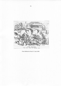
Photograph, The Roads: The High Road By Bakery Hill, 17/007/1856
... The Roads: The High Road By Bakery Hill......roads...A drawing of bad roads at Bakery Hill, Ballarat from the pages of Punch....The Roads: The High Road By Bakery Hill Photograph ...A drawing of bad roads at Bakery Hill, Ballarat from the pages of Punch.main road, bakery hill, roads -
Federation University Historical Collection
Document, Roads and Works in Grenville and Polworth, 1856, 1856
... Roads and Works in Grenville and Polworth, 1856...roads...Blue Foolscap printed Government document relating to roads and works in Grenville and Polworth. ...Barker Library (top floor) Mount Helen goldfields roads grenville polworth Blue Foolscap printed Government document relating to roads and works in Grenville and Polworth. ...Blue Foolscap printed Government document relating to roads and works in Grenville and Polworth. roads, grenville, polworth -
 Kew Historical Society Inc
Photograph, Corner of Cotham and Burke Roads, Kew, 1919
... Corner of Cotham and Burke Roads, Kew...Black and white photograph of the corner of Cotham and Burke Roads in Kew. The house at centre is 'Deepdene'. ...NEAR COTHAM ROAD CNR / HORSE TRANSPORT 1890s? / GIFT FROM BENNETT FAMILY...Burke Road, Kew, Greater Melbourne, Victoria, Australia...Kew Historical Society Inc Kew Court House 188 High Street Kew melbourne burke road (kew cotham road (kew) deepdene trams NEAR COTHAM ROAD CNR / HORSE TRANSPORT 1890s? ...Black and white photograph of the corner of Cotham and Burke Roads in Kew. The house at centre is 'Deepdene'. Public and private transport is represented by the two horses pulling a carriage into Whitehorse Road and the tram at the terminus. The photograph is one of two of the vista gifted by the Bennett family in 1980.NEAR COTHAM ROAD CNR / HORSE TRANSPORT 1890s? / GIFT FROM BENNETT FAMILYburke road (kew, cotham road (kew), deepdene, trams -
Whitehorse Historical Society Inc.
Document, Land Subdivision, cnr Springvale and Burwood Roads, n.d
... Land Subdivision, cnr Springvale and Burwood Roads...Springvale Road & Burwood Road, together with notes of various sales from 1857 to 1957....Hand drawn document of land subdivision, Springvale Road & Burwood Road, together with notes of various sales from 1857 to 1957....Whitehorse Historical Society Inc. 2-10 Deep Creek Road Mitcham melbourne Springvale Road & Burwood Road, together with notes of various sales from 1857 to 1957. ...Hand drawn document of land subdivision,Hand drawn document of land subdivision, Springvale Road & Burwood Road, together with notes of various sales from 1857 to 1957.Hand drawn document of land subdivision, burwood road, vermont south, springvale road, vermont south, stanley road, vermont south, vermont south, mayne, alexander, mayne, james alexander, craig, silas gordon, fankhauser, frederick william, fankhauser, mervyn william, burrell, charles, donaldson, john -
Dandenong & District Historical Society
Document - The Roads Board, Articles Concerning The Roads Board
... Articles Concerning The Roads Board...The Roads Board - Pics, Newspaper Article, History...Articles concerning The Roads Board...The Roads Board - Pics, Newspaper Article, History Articles concerning The Roads Board Articles Concerning The Roads Board Document The Roads Board ...The Roads Board - Pics, Newspaper Article, History -
 Ringwood and District Historical Society
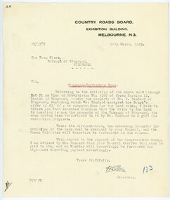
Letter, From Country Roads Board re compensation for road-widening land from Mr Bamford in 1929
... From Country Roads Board re compensation for road-widening land from Mr Bamford in 1929....It moved to its current location in Loughnan Road, Ringwood in 1997....From Country Roads Board re compensation for road-widening land from Mr Bamford. ...Dated 14th March 1929. From Country Roads Board re compensation for road-widening land from Mr Bamford in 1929. ...1929 saw the establishment of the Ringwood Bowls Club initially located on the land now occupied by the Eastland Shopping Centre. It moved to its current location in Loughnan Road, Ringwood in 1997.From Country Roads Board re compensation for road-widening land from Mr Bamford. Dated 14th March 1929.city of ringwood bowls club, ringwood bowling club, ringwood bowls club, lawn bowls, bowling -
 Greensborough Historical Society
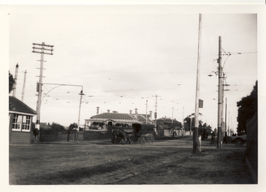
Photograph - Photograph (Framed), St Helena and Diamond Creek Roads Greensborough 1889, 1889
... St Helena and Diamond Creek Roads Greensborough 1889...A view of Greensborough township 1889, painted from the corner of St Helena Road and Diamond Creek Roads. This copy has been cropped from the original to show lower Main Street and Marble hall. ...Small timber-framed photograph of road and houses, sepia....Greensborough Historical Society 34A Glenauburn Road Lower Plenty Lower Plenty melbourne A view of Greensborough township 1889, painted from the corner of St Helena Road and Diamond Creek Roads. ...A view of Greensborough township 1889, painted from the corner of St Helena Road and Diamond Creek Roads. This copy has been cropped from the original to show lower Main Street and Marble hall. The original of this painting is owned by Greensborough Primary School.From the John Mackey collection. this item was displayed at the offices of Ryan, Mackey and Kelly, solicitors, Main Street Greensborough.Small timber-framed photograph of road and houses, sepia.greensborough, main street greensborough, marble hall greensborough, arthur elliott, john mackey -
 Phillip Island and District Historical Society Inc.
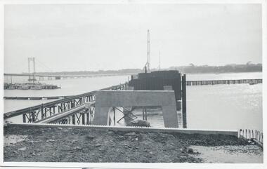
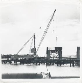
Photographs, Country Roads Board, Phillip Island 2nd Bridge Construction, 1966 - 1969
... Fifteen photographs from a collection of 70 taken at the construction of Phillip Island 2nd Bridge from 1966 - 1969 by Country Roads Board and Shire of Bass. Contractor John Holland & Co Pty Ltd....Fifteen Black & White photographs of the construction of the Phillip Island 2nd Bridge from 1966 - 1969 by Country Roads Board. Various photos of materials, machinery and people involved in the construction....Country Roads Board...Phillip Island 2nd Bridge Construction Photographs Country Roads Board ...Fifteen photographs from a collection of 70 taken at the construction of Phillip Island 2nd Bridge from 1966 - 1969 by Country Roads Board and Shire of Bass. Contractor John Holland & Co Pty Ltd.Fifteen Black & White photographs of the construction of the Phillip Island 2nd Bridge from 1966 - 1969 by Country Roads Board. Various photos of materials, machinery and people involved in the construction.351-50: CRB NEG No. 66-2860G. 351-51: CRB NEG No. 67-2866. 351-52: CRB NEG No. 67-2867B. 351-53: CRB NEG No. 66-2958A. 351-54: CRB NEG No. 66-2958B. 351-55: CRB NEG No. 67-3070E. 351-56: CRB NEG No. 67-3070F. 351-57: CRB NEG No. 64-3280B. 351-58: CRB NEG No. 67-3356G. 351-59: CRB NEG No. 66-3462D. 351-60: CRB NEG No. 66-3465G. 351-61: CRB NEG No. 66-3466D. 351-62: CRB NEG No. 67-3535D. 351-63: CRB NEG No. 67-3535H. 351-64: CRB NEG No. 67-3535M.phillip island 2nd bridge construction, phillip island bridge (1969), country roads board, shire of bass, john holland & co pty ltd, sasha stark -
 Stawell Historical Society Inc
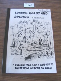
Book, Ida Stanton, Tracks, Roads & Bridges, In the Grampians, 2002
... Tracks, Roads & Bridges, In the Grampians ...A History of the Roads, Tracks and Bridges in the Grampians...TRacks, Roads and Bridges - In the Grampians. A Celebration and a Tribute to those who worked on them....Stawell Historical Society Inc 46 Longfield St Stawell grampians A History of the Roads, Tracks and Bridges in the Grampians stawell TRacks, Roads and Bridges - In the Grampians. ...A History of the Roads, Tracks and Bridges in the GrampiansCrean paper cover with a line drawing of "Entering the Gap" Circa 1870 by Laurie Evans. Plastic BindingTRacks, Roads and Bridges - In the Grampians. A Celebration and a Tribute to those who worked on them.stawell -
 Melbourne Tram Museum
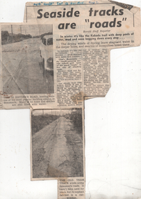
Newspaper, Herald Sun, "Seaside tracks are "roads"", 1955
... "Seaside tracks are "roads""...The article and photo report on the poor condition of roads in particular Hayden's Road and the former, short lived Victorian Railways Beaumaris - Black Rock tram line. ...Newspaper clipping titled - "Seaside tracks are "roads"" - Melbourne Herald 12/11/1955...Melbourne Tram Museum 8 Wallen Road Hawthorn melbourne The article and photo report on the poor condition of roads in particular Hayden's Road and the former, short lived Victorian Railways Beaumaris - Black Rock tram line. ...The article and photo report on the poor condition of roads in particular Hayden's Road and the former, short lived Victorian Railways Beaumaris - Black Rock tram line. Has two photos showing the road condition. The second photo shows sleepers from the former tram line and a badly worn road surface that had been placed on top. The item by a staff reporter likens the road to wartime battle fields. The tram line rails were lifted or removed during 1939 - see page 35 of The Brighton Electric Line.Yields information about the road condition in the Beaumaris area in 1955.Newspaper clipping titled - "Seaside tracks are "roads"" - Melbourne Herald 12/11/1955"Melb "Herald" Sat 12 Nov 1955"trams, tramways, vr trams, track maintenance, tram tracks, beaumaris -
 Orbost & District Historical Society
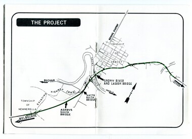
pamphlets, Princes Freeway - Orbost Section, 1976
... It was succeeded by the Road Construction authority on 1 July 1983 and later merged with the Road Traffic Authority on July 1 1989 to form the Roads Corporation. ...Three coloured Country Roads pamphlets for the 'Princes Freeway - Orbost Section". ...Country Roads Board...It was succeeded by the Road Construction authority on 1 July 1983 and later merged with the Road Traffic Authority on July 1 1989 to form the Roads Corporation. ...Opened by the Hon. J A Rafferty, Minister for Transport, 25 November 1976, the bridge was the first of four bridges to be built as part of the freeway bypass of Orbost. Construction cost $2.4 million. This construction was an important development along the Princes Highway corridor through East Gippsland. The original highway approached the Snowy River at a very poor alignment, and several serious accidents had occurred at the Orbost end. In times of heavy flood, the highway on both sides of the river had been cut by floodwaters and during the 1971 floods, the highest ever recorded, the river was a mile wide at the crossing. Construction of the bridges commenced in January 1975, with an expectation to open the bridge across the Snowy River as soon as possible. Less than two years later, on 25 November 1976, the bridge across the Snowy River was opened to traffic, allowing the old bridge to be demolished. The remainder of the Orbost Bypass, both the floodplain crossings and the eastern section around the township itself, was declared ‘Princes Freeway’ and opened to traffic in December 1977. (ref http://mrv.ozroads.com.au) The Country Roads Board was the government authority for the construction and maintenance of main roads in Victoria between 1913 and 1983. It was succeeded by the Road Construction authority on 1 July 1983 and later merged with the Road Traffic Authority on July 1 1989 to form the Roads Corporation. James Cameron, an Orbost farming pioneer and Member of the Legislative Assembly, fathered the Country Roads Board. The opening of this Snowy River Bridge was an important development in the accessibility to the township of Orbost.Three coloured Country Roads pamphlets for the 'Princes Freeway - Orbost Section". On the front is a coloured photograph of the new construction over the Snowy River at Orbost. Inside is a program for a ceremony for the opening of the new Snowy River Bridge. There is also a black print map of the project. -
 Greensborough Historical Society
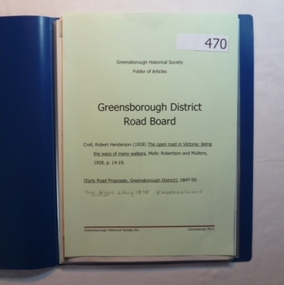
Folder, Greensborough District Roads Board, 1847o
... Greensborough District Roads Board...Contents: The open road in Victoria [excerpt] by R H Croll; Newspaper articles on early road proposals in Greensborough area; Newspaper article from The Argus on Embezzelment of monies from Roads Board....Contains documents relating to the Greensborough District Roads Board....Greensborough Historical Society 34A Glenauburn Road Lower Plenty Lower Plenty melbourne Contents: The open road in Victoria [excerpt] by R H Croll; Newspaper articles on early road proposals in Greensborough area; Newspaper article from The Argus on Embezzelment of monies from Roads Board. greensborough district roads board robert henderson croll charles buck 20-page plastic binder, blue cover. ...Contents: The open road in Victoria [excerpt] by R H Croll; Newspaper articles on early road proposals in Greensborough area; Newspaper article from The Argus on Embezzelment of monies from Roads Board.20-page plastic binder, blue cover. Contains documents relating to the Greensborough District Roads Board.greensborough district roads board, robert henderson croll, charles buck -
Lakes Entrance Historical Society
Financial record - Ledger, Country Roads Board Wages Ledger 1953, 1953
... Country Roads Board Wages Ledger 1953...A Ledger of Wages paid to Country Roads Board employees of East Gippsland Victoria...A Ledger of Wages paid to Country Roads Board employees of East Gippsland Victoria...A Ledger of Wages paid to Country Roads Board employees of East Gippsland Victoria Accounts book A Ledger of Wages paid to Country Roads Board employees of East Gippsland Victoria Country Roads Board Wages Ledger 1953 Financial record Ledger Shire of Tambo ...A Ledger of Wages paid to Country Roads Board employees of East Gippsland VictoriaA Ledger of Wages paid to Country Roads Board employees of East Gippsland Victoriaaccounts book -
Ringwood and District Historical Society
Pamphlet, Vic Roads, Eastern Freeway: Doncaster Road to Springvale Road extension, and Scoresby Transport Corridor. Pamphlets. 1993-6, 1993-1994 & 1996
... Eastern Freeway: Doncaster Road to Springvale Road extension, and Scoresby Transport Corridor. ...Eastern Freeway: Doncaster Road to Springvale Road extension - 2 pamphlets;; Scoresby Transport Corridor: 1 pamphlet....Vic Roads...Ringwood and District Historical Society 125A Warrandyte Road Ringwood North melbourne Eastern Freeway: Doncaster Road to Springvale Road extension - 2 pamphlets;; Scoresby Transport Corridor: 1 pamphlet. ...Eastern Freeway: Doncaster Road to Springvale Road extension - 2 pamphlets;; Scoresby Transport Corridor: 1 pamphlet. -
 Phillip Island and District Historical Society Inc.
Photographs, Country Roads Board, Phillip Island 2nd Bridge Construction, 1966 - 1969
... 13 Black & White photographs from a collection of 70 of the construction of the second bridge for Phillip Island from San Remo to Newhaven by Country Roads Board - contrator John Holland & Co Pty. ...13 Black & White photographs of the construction of the second Phillip Island Bridge from San Remo to Newhaven by Country Roads Boards from 1966 to 1969. All photos taken at various times throughout the construction showing the materials, machinery and men involved....Country Roads Board...Phillip Island 2nd Bridge Construction Photographs Country Roads Board ...13 Black & White photographs from a collection of 70 of the construction of the second bridge for Phillip Island from San Remo to Newhaven by Country Roads Board - contrator John Holland & Co Pty. Ltd. Shire of Bass.13 Black & White photographs of the construction of the second Phillip Island Bridge from San Remo to Newhaven by Country Roads Boards from 1966 to 1969. All photos taken at various times throughout the construction showing the materials, machinery and men involved.351-23: CRB NEG No. 67-1219. 351-24: CRB NEG No. 67-1220. 351-25: CRB NEG No. 67-1291A. 351-26: CRB NEG No. 67-1629B. 351-27: CRB NEG No. 67-1629D. 351-28: CRB NEG No. 67-1629E. 351-29: CRB NEG No. 67-1630A. 351-30: CRB NEG No. 67-1630C. 351-31: CRB NEG No. 67-1630D. 351-32: CRB NEG No. 67-1825A. 351-33: CRB NEG No. 67-1825F. 351-34: CRB NEG No. 67-1826C. 351-35: CRB NEG No. 67-1826D.2nd phillip island bridge construction, phillip island bridge construction, country roads board, shire of bass, john holland & co pty ltd, sasha stark -
 Ringwood and District Historical Society
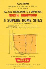
Flyer, Land Auction, Cnr Warrandyte and Oban Roads, North Ringwood, Vic. - 1974
... Land Auction, Cnr Warrandyte and Oban Roads, North Ringwood, Vic. - 1974...Details include vendor terms, subdivision services, and location map (north-east corner of Warrandyte and Oban Roads)....Later handwritten notation suggests vendor was possibly Country Roads Board (VicRoads) after completion of road widening works....Later handwritten notation suggests vendor was possibly Country Roads Board (VicRoads) after completion of road widening works. ...Single yellow page advertising Auction of five home sites to be sold separately on Saturday, 11th May, 1974. Details include vendor terms, subdivision services, and location map (north-east corner of Warrandyte and Oban Roads).(Agent) Eric Weber & Co. Pty. Ltd., 148 Wellington Parade, East Melbourne, 3002, Phone: 416025, Mr Elliott A.H. 8577502. Later handwritten notation suggests vendor was possibly Country Roads Board (VicRoads) after completion of road widening works. -
 Eltham District Historical Society Inc
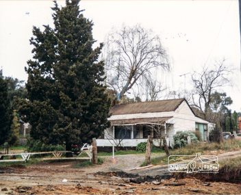
Photograph, Miner's Cottage, corner Main and Reynolds roads, Research, Vic, 1986
... Miner's Cottage, corner Main and Reynolds roads, Research, Vic....Miner's Cottage, owned by Mrs Ivy Reynolds at the corner of Main Road and Reynolds Road, Eltham. Wal and Bernie Dodkins, rented the house from around 1938 until they left in the 1970s to become caretakers at the Kangaroo Ground Tower. ...Three views show widening of Main Road....Three views show widening of Main Road. Miner's Cottage, corner Main and Reynolds roads, Research, Vic. ...Miner's Cottage, owned by Mrs Ivy Reynolds at the corner of Main Road and Reynolds Road, Eltham. Wal and Bernie Dodkins, rented the house from around 1938 until they left in the 1970s to become caretakers at the Kangaroo Ground Tower. Lyn Dodkins (wife of Graeme Hardiman) was born there and lived in this house for her first 19 years. [Graeme Hardiman email 5 Aug 2022] The site was developed for commercial use as the Eltham Motor Inn, which permanently closed about 2024 and has since been refurbished for use as rental units (2025).Six colour photographs of old cottage corner Main and Reynolds roads at Research in 1986. The cottage was built by/for Grandfather Reynolds and was demolished 2 Mar 1987. Three views show widening of Main Road.houses, main road, reynolds road, research (vic.), lyn dodkins, wal dodkins, bernie dodkins, miss reynolds, dodkins family, eltham, eltham motor inn, ivy reynolds, miner's cottage -
 Surrey Hills Historical Society Collection
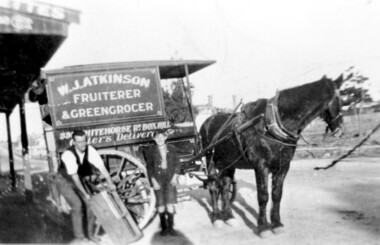
Photograph, Delivery cart outside Mr & Mrs W. J. Atkinsons's greengrocery business near the corner of Elgar and Whitehorse Roads, c1930
... Atkinsons's greengrocery business near the corner of Elgar and Whitehorse Roads, c1930...They ran a mixed business in Whitehorse Road from 1926-1952. Stock included fruit and vegetables, sweets and some groceries. ...Atkinson Fruiterer and Greengrocer, 33? Whitehorse Road Box Hill....Surrey Hills Historical Society Collection 190A Canterbury Road Canterbury melbourne Delivery cart of Mr & Mrs W J Atkinson’s greengrocery business and general store near the corner of Whitehorse and Elgar Roads, c 1930. ...Delivery cart of Mr & Mrs W J Atkinson’s greengrocery business and general store near the corner of Whitehorse and Elgar Roads, c 1930. Emma Uebergang and William James Atkinson married in 1930. They ran a mixed business in Whitehorse Road from 1926-1952. Stock included fruit and vegetables, sweets and some groceries. With Mr Atkinson is Albert Cunnington who in about 1930 helped with deliveries. To the left can be seen Whitehorse Road as it approaches the shopping centre and over the back of the horse can be seen the White Horse Hotel. This was demolished in 1938.A black and white photograph of a horse and delivery cart identified as W. J. Atkinson Fruiterer and Greengrocer, 33? Whitehorse Road Box Hill.land transport, carts and wagons, horse drawn vehicles, fruiterer and greengrocer, whitehorse road, elgar road, mont albert, box hill, mr william james atkinson, mrs emma gertrude atkinson, miss emma gerte uebergang, mr albert cunningham