Showing 45417 items matching " roads and streets"
-
 Ballarat Tramway Museum
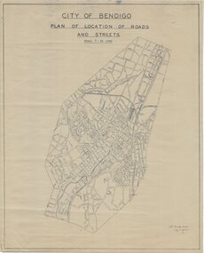
Plan - City of Bendigo, City of Bendigo, Plan of Location of Roads and Streets, 1948
... Plan of Location of Roads and Streets. ...City of Bendigo document, unnumbered; "Plan of Location of Roads and Streets.". Drawn 1948. Original dyeline print....Plan of Location of Roads and Streets. Plan City of Bendigo. City of Bendigo ...Produced by City of Bendigo, signed by the City Engineer J.L. Hicks, 1948.Print of a drawing showing in very good detail, a map of Bendigo in 1948. Document was hand signed by the City Engineer J.L. Hicks.City of Bendigo document, unnumbered; "Plan of Location of Roads and Streets.". Drawn 1948. Original dyeline print.Original dyeline print.provincial tramways, state electricity commission of victoria, map, ballarat, bus routes -
 Kew Historical Society Inc
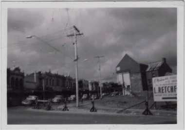
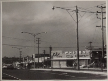
Photograph - Kew Junction during road widening, December 1958
... Kew Junction is the intersection of five major roads - Denmark Street, High Street, High Street South, Studley Park Road and Princess Street. ...Original, black and white positive of Kew Junction, including the corner with Denmark Street during road widening in the 1958....Inscribed verso: "Kew Junction Dec 1958 / When the road was being widened by the removal of a number of shops / Notice saying Retchford's Estate agency's temporary office is at the top end of Denmark Street, Kew"...Kew Historical Society Inc Kew Court House 188 High Street Kew melbourne Kew Junction is the intersection of five major roads - Denmark Street, High Street, High Street South, Studley Park Road and Princess Street. ...Kew Junction is the intersection of five major roads - Denmark Street, High Street, High Street South, Studley Park Road and Princess Street. The original widening of High Street in the 1930s expanded that street by removing shops on the south side of the street from Cotham Road to Denmark Street. Further widening in 1958 removed shops at the west end of High Street to allow for increased traffic using Princes Street and Denmark Street.Original, black and white positive of Kew Junction, including the corner with Denmark Street during road widening in the 1958.Inscribed verso: "Kew Junction Dec 1958 / When the road was being widened by the removal of a number of shops / Notice saying Retchford's Estate agency's temporary office is at the top end of Denmark Street, Kew"kew junction, denmark street -- kew (vic.), major roadworks -- kew (vic.) -
 Kew Historical Society Inc
Photograph, Stuart Tompkins Studio, Electricity Supply Poles, Warrigal Road, Ashwood, 1965
... Research provided by Stuart Tompkins Studio, Box Hill, into alternatives for median strip street lighting to be used in Burke Road, Kew. ...The photograph, taken at the intersection of Warrigal Road and High Street South, Ashwood looks north along High Street Road. ...Photographed for Kew City Council 8/2/65. No.4 Warrigal Road - Ashwood. South of High Street Road looking north. ...The photograph, taken at the intersection of Warrigal Road and High Street South, Ashwood looks north along High Street Road. ...Research provided by Stuart Tompkins Studio, Box Hill, into alternatives for median strip street lighting to be used in Burke Road, Kew. The photographers identified variants in different suburbs appropriate to Kew's needs.The series from which the photograph is drawn provides a snapshot by a commercial photographic studio of each named vicinity in 1965 as well as providing examples of public works infrastructure being commissioned by local government in the 1960s. The photos originally formed part of the Engineering Department's files in the City of Kew before being donated to the kew Historical Society.Electricity Supply Poles, Warrigal Road, Ashwood, 1965. Stuart Tompkins Studio provided this photograph for the Kew City Council. The photograph, taken at the intersection of Warrigal Road and High Street South, Ashwood looks north along High Street Road. The intent of the photograph was to provide the Council with models of electricity supply poles. In the photo, wooden and steel poles can be seen in the median strip. The photograph also includes the shops bordering High Street Road during this period. [There are three copies of this photograph in the Collection.]. Typed inscription on reverse: "Electricity Supply Poles. Photographed for Kew City Council 8/2/65. No.4 Warrigal Road - Ashwood. South of High Street Road looking north. Wooden and steel poles with different brackets in median strip." Studio stamp: "Stuart Tompkins Studio. 547 Station Street, Box Hill. WX1439."electric light poles, public works -- 1960s, civic infrastructure -- 1960s -
 Kew Historical Society Inc
Photograph, Stuart Tompkins Studio, Electricity Supply Poles, Warrigal Road, Ashwood, 1965
... Research provided by Stuart Tompkins Studio, Box Hill, into alternatives for median strip street lighting to be used in Burke Road, Kew. ...The photograph, taken at the intersection of Warrigal Road and High Street South, Ashwood looks north along High Street Road. ...Photographed for Kew City Council 8/2/65. No.4 Warrigal Road - Ashwood. South of High Street Road looking north. ...The photograph, taken at the intersection of Warrigal Road and High Street South, Ashwood looks north along High Street Road. ...Research provided by Stuart Tompkins Studio, Box Hill, into alternatives for median strip street lighting to be used in Burke Road, Kew. The photographers identified variants in different suburbs appropriate to Kew's needs.The series from which the photograph is drawn provides a snapshot by a commercial photographic studio of each named vicinity in 1965 as well as providing examples of public works infrastructure being commissioned by local government in the 1960s. The photos originally formed part of the Engineering Department's files in the City of Kew before being donated to the kew Historical Society.Electricity Supply Poles, Warrigal Road, Ashwood, 1965. Stuart Tompkins Studio provided this photograph for the Kew City Council. The photograph, taken at the intersection of Warrigal Road and High Street South, Ashwood looks north along High Street Road. The intent of the photograph was to provide the Council with models of electricity supply poles. In the photo, wooden and steel poles can be seen in the median strip. The photograph also includes the shops bordering High Street Road during this period. [There are three copies of this photograph in the Collection.]. Typed inscription on reverse: "Electricity Supply Poles. Photographed for Kew City Council 8/2/65. No.4 Warrigal Road - Ashwood. South of High Street Road looking north. Wooden and steel poles with different brackets in median strip." Studio stamp: "Stuart Tompkins Studio. 547 Station Street, Box Hill. WX1439."electric light poles, civic infrastructure - 1960s, public works -- 1960s -
 Kew Historical Society Inc
Photograph, Stuart Tompkins Studio, Electricity Supply Poles, Warrigal Road, Ashwood, 1965
... Research provided by Stuart Tompkins Studio, Box Hill, into alternatives for median strip street lighting to be used in Burke Road, Kew. ...The photograph, taken at the intersection of Warrigal Road and High Street South, Ashwood looks north along High Street Road. ...Photographed for Kew City Council 8/2/65. No.4 Warrigal Road - Ashwood. South of High Street Road looking north. ...The photograph, taken at the intersection of Warrigal Road and High Street South, Ashwood looks north along High Street Road. ...Research provided by Stuart Tompkins Studio, Box Hill, into alternatives for median strip street lighting to be used in Burke Road, Kew. The photographers identified variants in different suburbs appropriate to Kew's needs.The series from which the photograph is drawn provides a snapshot by a commercial photographic studio of each named vicinity in 1965 as well as providing examples of public works infrastructure being commissioned by local government in the 1960s. The photos originally formed part of the Engineering Department's files in the City of Kew before being donated to the kew Historical Society.Electricity Supply Poles, Warrigal Road, Ashwood, 1965. Stuart Tompkins Studio provided this photograph for the Kew City Council. The photograph, taken at the intersection of Warrigal Road and High Street South, Ashwood looks north along High Street Road. The intent of the photograph was to provide the Council with models of electricity supply poles. In the photo, wooden and steel poles can be seen in the median strip. The photograph also includes the shops bordering High Street Road during this period. [There are three copies of this photograph in the Collection.]. Typed inscription on reverse: "Electricity Supply Poles. Photographed for Kew City Council 8/2/65. No.4 Warrigal Road - Ashwood. South of High Street Road looking north. Wooden and steel poles with different brackets in median strip." Studio stamp: "Stuart Tompkins Studio. 547 Station Street, Box Hill. WX1439."electric light poles, public infrastructure -- 1960s, civic works -- 1960s -
 Ringwood and District Historical Society
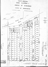
Document - Map, Plan of Subdivision, Part of Crown Portion 11, Parish of Ringwood, County of Mornington - circa 1890
... A4 photocopy showing numbers and perimeter measurements of allotments on Station Street (previously Railway Avenue), Wantirna Road (previously West Prussia Road), James Street and Kendall Street (previously William Street). ...Railway Avenue was re-named Station Street. Date missing from street name amendment from West Prussia Road to Wantirna Road....Railway Avenue was re-named Station Street. Date missing from street name amendment from West Prussia Road to Wantirna Road. ...A4 photocopy showing numbers and perimeter measurements of allotments on Station Street (previously Railway Avenue), Wantirna Road (previously West Prussia Road), James Street and Kendall Street (previously William Street). Notations include incorrect order of street name amendment between Station Street and Railway Avenue in 1952. Railway Avenue was re-named Station Street. Date missing from street name amendment from West Prussia Road to Wantirna Road. -
 City of Kingston
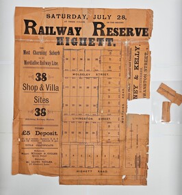
Pamphlet - Colour, Duffus Bros, Railway Reserve Highett, c. 1923
... Sales plan for land in the suburb of Highett, titled Railway Reserve, incorporating properties along Wolseley Street, Livingston Street, Highett Road and Worthing Road. ...Incorporates a map of the reserve with properties available on Wolseley Street, Livingston Street, Highett Road and Worthing Road. ...Nevill / City of Melbourne bank Handwritten in grey pencil across subdivision 7: 49' Handwritten in grey pencil across subdivision 21 and 22: 134' Handwritten in grey pencil across subdivision 25 and 26: 200' Handwritten in grey pencil across subdivision 36 and 37 and both top and bottom: 120' Hand drawn in blue pencil: outline of subdivision 4 Hand drawn in blue pencil: outline of subdivisions 7, 23, 28, 37, 38 along left hand side, subdivisions 38, 37 and 36 on Wolseley Street, subdivisions 30 and 29 along Wolseley Street, subdivisions 29 and 24 along the middle of the plan, subdivisions 24 and half of 25 along Livingston Street, half of subdivision 20 along the middle of the plan, subdivisions 21 and 22 along the Right of Way between Livingston Street and Highett Road, and along the right hand border of subdivision 7. ...City of Kingston Parkdale Library 96 Parkers Road, Parkdale Parkdale Sales plan for land in the suburb of Highett, titled Railway Reserve, incorporating properties along Wolseley Street, Livingston Street, Highett Road and Worthing Road. ...Sales plan for land in the suburb of Highett, titled Railway Reserve, incorporating properties along Wolseley Street, Livingston Street, Highett Road and Worthing Road. The developing urban area of Highett within the City of Kingston. This land sale pamphlet illustrates the subdivision of land within the municipality and the changing demographic of the district as new houses and shops are constructed close to infrastructure.Colour pamphlet advertising thirty eight shop and villa sites for sale at the Railway Reserve, Highett. Incorporates a map of the reserve with properties available on Wolseley Street, Livingston Street, Highett Road and Worthing Road. Handwritten in grey pencil: assumed sale price recorded on subdivisions 1-7, 10, 22, 23 and 34 Handwritten in grey pencil on subdivision 4: C. Nevill / City of Melbourne bank Handwritten in grey pencil across subdivision 7: 49' Handwritten in grey pencil across subdivision 21 and 22: 134' Handwritten in grey pencil across subdivision 25 and 26: 200' Handwritten in grey pencil across subdivision 36 and 37 and both top and bottom: 120' Hand drawn in blue pencil: outline of subdivision 4 Hand drawn in blue pencil: outline of subdivisions 7, 23, 28, 37, 38 along left hand side, subdivisions 38, 37 and 36 on Wolseley Street, subdivisions 30 and 29 along Wolseley Street, subdivisions 29 and 24 along the middle of the plan, subdivisions 24 and half of 25 along Livingston Street, half of subdivision 20 along the middle of the plan, subdivisions 21 and 22 along the Right of Way between Livingston Street and Highett Road, and along the right hand border of subdivision 7. Handwritten in ink adjacent to the subdivision plan, updside down, in the bottom right hand corner: 276 / 54 / 280 / 45 / 320 / 202 / 200 / 134 / horizontal line / 11/14 Handwritten in ink adjacent to the subdivision plan, updside down, in the bottom right hand corner: 1714)2200(15 / 1714 / horizontal line / 486land sales, highett -
 Eltham District Historical Society Inc
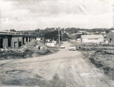
Photograph, Brisbane Street, Eltham (unmade) from west end, 1969, 1969
... ...roads...verso: Brisbane Street before road made 1967 looking east ...Eltham District Historical Society Inc 728 Main Rd Eltham melbourne Brisbane Street, Eltham (unmade) from west end, showing light industrial area 1969 eltham 1969 roads streets brisbane street light industrial area verso: Brisbane Street before road made 1967 looking east black and white photograph with white border Brisbane Street, Eltham (unmade) from west end, 1969 Photograph ...Brisbane Street, Eltham (unmade) from west end, showing light industrial area 1969black and white photograph with white borderverso: Brisbane Street before road made 1967 looking east eltham, 1969, roads, streets, brisbane street, light industrial area -
 Canterbury History Group
Photograph - Street view of the corner of Maling Road and Bryson Street depicting the shop No. 92. Maling Road, Jan Pigot, 1994
... Street view of the corner of Maling Road and Bryson Street depicting the shop at 92 Maling Road...Street view of thde corner of Maling Road and Bryson Street depicting the shop at 92 Maling Road...Street view of the corner of Maling Road and Bryson Street depicting the shop at 92 Maling Road Canterbury Maling Road Shops Bryson Street Buckley Family The Block Street view of thde corner of Maling Road and Bryson Street depicting the shop at 92 Maling Road Photograph Street view of the corner of Maling Road and Bryson Street depicting the shop No. 92. ...Street view of the corner of Maling Road and Bryson Street depicting the shop at 92 Maling RoadStreet view of thde corner of Maling Road and Bryson Street depicting the shop at 92 Maling Roadcanterbury, maling road, shops, bryson street, buckley family, the block -
 Tarnagulla History Archive
Postcard - Photographic postcard: Commercial Road, Tarnagulla looking south from Poverty Street, c. 1910
... Photographic postcard, front image depicting Commercial Road, Tarnagulla looking south from Poverty Street. ... Handwritten on reverse: '1/2 main street, Commercial Road, Tarnagulla' and 'L.Williams Tarnagulla'...Postcard Photographic postcard: Commercial Road, Tarnagulla looking south from Poverty Street ...Williams Family Collection. Photographic postcard, front image depicting Commercial Road, Tarnagulla looking south from Poverty Street. Handwritten on reverse: '1/2 main street, Commercial Road, Tarnagulla' and 'L.Williams Tarnagulla'tarnagulla -
 Kew Historical Society Inc
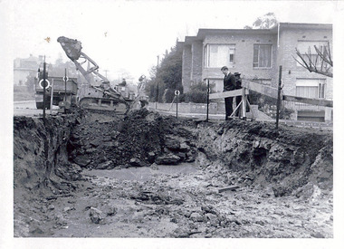
Photograph - Road works in the City of Kew, 1968-9
... Original black and white photographic positive of a road works in the former City of Kew. The photo shows an excavation in Studley Park Road near the corner of Carson Street in 1968/9. ...STUDLEY PARK ROAD AT CARSON STREET 1968/9...The photographs are an accurate record of street works of the period. city of kew local government -- city of kew road works street works kew city depot Studley Park Road -- KEW (VIC.) ...One of a series of photographs donated by the City Engineer of the former City of Kew, showing road works. The photos variably include council workers, signage and equipment.One of a series of photographs of core local government services as practised by the City of Kew. The photographs are an accurate record of street works of the period. Original black and white photographic positive of a road works in the former City of Kew. The photo shows an excavation in Studley Park Road near the corner of Carson Street in 1968/9. A Council officer and worker inspect the pit. Excavation equipment and a Council truck are at the back of the view. STUDLEY PARK ROAD AT CARSON STREET 1968/9city of kew, local government -- city of kew, road works, street works, kew city depot, studley park road -- kew (vic.) -
 City of Kingston
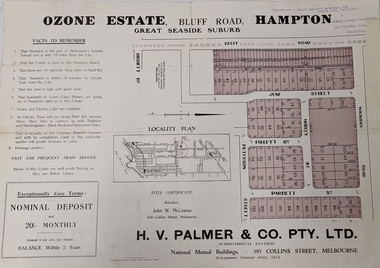
Pamphlet - Colour, Farrow Falcon Press, Printers, Ozone Estate, Bluff Road, Hampton, c.1940
... Sales plan for land in the suburb of Hampton (Highett), bounded by Bluff Road, Wickham Road, Peterson Street and June Street. ...Colour pamphlet advertising for private sale the Ozone Estate, Bluff Road Hampton. Incorporates a map of the estate bordered by Bluff Road, Wickham Road, June Street and Peterson Street including Morley Street, Follett Avenue and Parrett Street....City of Kingston Parkdale Library 96 Parkers Road, Parkdale Parkdale Sales plan for land in the suburb of Hampton (Highett), bounded by Bluff Road, Wickham Road, Peterson Street and June Street. ...Sales plan for land in the suburb of Hampton (Highett), bounded by Bluff Road, Wickham Road, Peterson Street and June Street. Includes Morley Street, Follett Avenue, and Parrett StreetThe developing urban area of Highett within the City of Kingston. This land sale pamphlet illustrates the subdivision of land within the municipality and the changing demographic of the district as new houses are constructed close to infrastructure.Colour pamphlet advertising for private sale the Ozone Estate, Bluff Road Hampton. Incorporates a map of the estate bordered by Bluff Road, Wickham Road, June Street and Peterson Street including Morley Street, Follett Avenue and Parrett Street.Handwritten in grey pencil on reverse: Ozone Printed in purple ink on front top right-hand corner: Vendors are - Leslie Harcourt MacGowan, Esq / Neerim Road, Caulfield / & / Arthur Alfred Parrett, Esq / 311 Flinders Lane / Melbourneland sales, estate, hampton, highett -
 City of Kingston
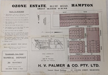
Pamphlet - Colour, Farrow Falcon Press, Printers, Ozone Estate, Bluff Road, Hampton, c. 1940
... Sales plan for land in the suburb of Hampton (Highett), bounded by Bluff Road, Wickham Road, Peterson Street and June Street. ...Colour pamphlet advertising for private sale the Ozone Estate, Bluff Road Hampton. Incorporates a map of the estate bordered by Bluff Road, Wickham Road, June Street and Peterson Street including Morley Street, Follett Avenue and Parrett Street....City of Kingston Parkdale Library 96 Parkers Road, Parkdale Parkdale Sales plan for land in the suburb of Hampton (Highett), bounded by Bluff Road, Wickham Road, Peterson Street and June Street. ...Sales plan for land in the suburb of Hampton (Highett), bounded by Bluff Road, Wickham Road, Peterson Street and June Street. Includes Morley Street, Follett Avenue, and Parrett StreetThe developing urban area of Highett within the City of Kingston. This land sale pamphlet illustrates the subdivision of land within the municipality and the changing demographic of the district as new houses are constructed close to infrastructure.Colour pamphlet advertising for private sale the Ozone Estate, Bluff Road Hampton. Incorporates a map of the estate bordered by Bluff Road, Wickham Road, June Street and Peterson Street including Morley Street, Follett Avenue and Parrett Street.Handwritten in grey pencil on rear: Ozone Estateland sales, estate, highett, hampton -
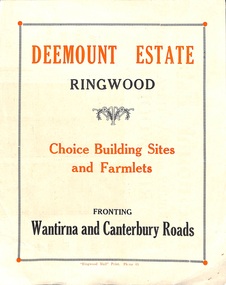 Ringwood and District Historical Society
Flyer, Subdivisional Land Sale advertisement - Deemount Estate, Ringwood, Vic. - c.1950
... Additional undated hand-drawn map on light cardboard - 4 allotments on western side of Maidstone Street ....Subdivision includes Canterbury Road, Wantirna Road and Maidstone Street....Ringwood and District Historical Society 125A Warrandyte Road Ringwood North melbourne Subdivision includes Canterbury Road, Wantirna Road and Maidstone Street. ...Double sided folded page with black and orange advertisement and blueprint for Deemount Estate fronting Canterbury and Wantirna Roads, Ringwood, with handwritten price list and terms of sale. Additional undated hand-drawn map on light cardboard - 4 allotments on western side of Maidstone Street .Subdivision includes Canterbury Road, Wantirna Road and Maidstone Street. -
 Sunshine and District Historical Society Incorporated
Photograph - St. Albans Road And Gilmour Road Sunshine North 1991 Photographs, Sharon Cavanagh, 11th August 1990
... These photographs, taken by The Advocate in 1991 as part of its Street Watch campaign, document the condition of St Albans Road and Gilmour Road in Sunshine North....Street Watch Road Condition St. Albans Road and Gilmour Road St. ...These photographs, taken by The Advocate in 1991 as part of its Street Watch campaign, document the condition of St Albans Road and Gilmour Road in Sunshine North. ...These photographs, taken by The Advocate in 1991 as part of its Street Watch campaign, document the condition of St Albans Road and Gilmour Road in Sunshine North.Photographs like these of poor road condition stories are politically powerful, bad roads are a visible symbol of state and local government performance. Media know that potholes, crumbling highways, and unsafe arterials become shorthand for “government neglect.” Opposition parties use road deterioration as a key attack line. Governments respond with funding announcements, audits, and “repair blitzes.” This creates a constant news cycle: complaint → political reaction → follow‑up story.Street Watch Road Condition St. Albans Road and Gilmour Road St. Albans 381.2st. albans road, gilmour road, sunshine north -
 Kew Historical Society Inc
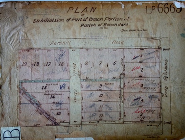
Plan - Subdivision Plan, J R Mathers & McMillan, Plan of Subdivision of Part of Crown Portion 83 at Kew : LP6669, 1923-1939
... In 1888, in the section of Park Hill Road between Belmont Avenue and Normanby Road there was only one street running between Park Hill Road and Cotham Road. ...Hand-drawn subdivision plan of 19 lots facing Parkhill Road, Normanby Road, and an unnamed street [now Cecil Street] in Kew....Kew Historical Society Inc Kew Court House 188 High Street Kew melbourne In 1888, in the section of Park Hill Road between Belmont Avenue and Normanby Road there was only one street running between Park Hill Road and Cotham Road. ...In 1888, in the section of Park Hill Road between Belmont Avenue and Normanby Road there was only one street running between Park Hill Road and Cotham Road. This was Park Road, later to be named Adeney Avenue. Subsequent 20th century subdivisions created the ‘through roads’ of Cecil Street, Wimba Avenue, Florence Avenue, Marshall Avenue, Uvadale Road, and Barrington Avenue. This subdivision represents an attempt by auctioneers, rather than town planners to create an urban environment from larger residential allotments or in many cases farmland. Existing streets such as Parkhill and Normanby Roads provided a convenient starting point for the surveyors, but the Road named ‘Street Street’ indicates the role of the private surveyor in creating streets. Given that a number of allotments are listed as sold on the plan, the street is presumably Cecil Street. Even those lots that had been sold do not quite match the dimensions of the blocks in this parcel of land today, indicating that either further subdivisions or boundary alterations occurred.Subdivision plans are historically important documents used as evidence for the growth of suburbs in Australia. They frequently provide information about when the land was sold as well as evidence relating to surveyors and real estate and financial agents. The numerous subdivision plans in the Kew Historical Society's collection represent working documents, ranging from the initial sketches made in planning a subdivision to printed plans on which auctioneers or agents listed the prices for which individual lots were sold. In a number of cases, the reverse of a subdivision plan in the collection includes a photograph of a house that was also for sale by the agent. These photographs provide significant heritage information relating house design and decoration, fencing and household gardens.The photograph may also be aesthetically significant depending on the importance of the photographic atelier.Hand-drawn subdivision plan of 19 lots facing Parkhill Road, Normanby Road, and an unnamed street [now Cecil Street] in Kew.Estate Agent notes in ink indicate those lots which had sold.subdivision plans - kew, parkhill road - kew, cecil street - kew, normanby road - kew, cecil street -kew, parkhill road - kew, normanby road - kew, crown portion 83 - kew -
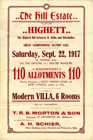
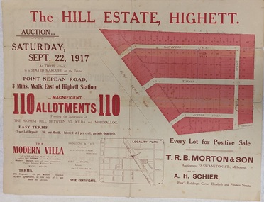 City of Kingston
Pamphlet - Colour, Stillwell and Co, The Hill Estate, Highett, 1917
... Sales plan for land in the suburb of Highett, bounded by Point Nepean Road and including Sandford Street, Turner Road, Alfred Street and Peace Street....Incorporates a map of the estate bordered by Point Nepean Road and including Sandford Street, Turner Road, Alfred Street and Peace Street....City of Kingston Parkdale Library 96 Parkers Road, Parkdale Parkdale Sales plan for land in the suburb of Highett, bounded by Point Nepean Road and including Sandford Street, Turner Road, Alfred Street and Peace Street. ...Sales plan for land in the suburb of Highett, bounded by Point Nepean Road and including Sandford Street, Turner Road, Alfred Street and Peace Street.The developing urban area of Highett within the City of Kingston. This land sale pamphlet illustrates the subdivision of land within the municipality and the changing demographic of the district as new houses are constructed close to infrastructure.Colour pamphlet advertising for sale at auction The Hill Estate, Highett. Incorporates a map of the estate bordered by Point Nepean Road and including Sandford Street, Turner Road, Alfred Street and Peace Street.Handwritten in grey pencil on subdivision map next to subdivisions 91, 92, 93, 106, 107 and 108: x Handwritten in grey pencil on back cover: The / Hill Estate / Highettland sales, estate, highett -
 Sunshine and District Historical Society Incorporated
Photograph - Footbridge over Kororoit Creek Yallourn Street to Ballarat Road Ardeer, Johnson, Des, 7 Nov., 1988
... Footbridge over Kororoit Creek from Yallourn Street Ardeer to Ballarat Road Albion constructed 1953 to 1954 under the supervision of City Of Sunshine Road Engineer Norm Stores of Albion...1 to 6 This square blue stone foot bidge was originated by Norm stores of Derrimut Street Albion who was a Road engineer for Sunshine City Council between Yallourn Street and Sun Hill Crescent and Ballarat Road Ardeer C 1953 to 1954 Melway Map 26 B9...Donated to S&DHS Kororoit Creek Ardeer Bridge 1 to 6 This square blue stone foot bidge was originated by Norm stores of Derrimut Street Albion who was a Road engineer for Sunshine City Council between Yallourn Street and Sun Hill Crescent and Ballarat Road Ardeer C 1953 to 1954 Melway Map 26 B9 Footbridge over Kororoit Creek from Yallourn Street Ardeer to Ballarat Road Albion constructed 1953 to 1954 under the supervision of City Of Sunshine Road Engineer Norm Stores of Albion Photograph Footbridge over Kororoit Creek Yallourn Street to Ballarat Road Ardeer Johnson, Des. ...Donated to S&DHS1 to 6 This square blue stone foot bidge was originated by Norm stores of Derrimut Street Albion who was a Road engineer for Sunshine City Council between Yallourn Street and Sun Hill Crescent and Ballarat Road Ardeer C 1953 to 1954 Melway Map 26 B9kororoit creek, ardeer, bridge -
 City of Kingston
Pamphlet - Colour, Stillwell and Co, The Hill Estate Highett Great Subdivisional Auction Sale, 1917
... Sales plan for land in the suburb of Highett, bounded by Point Nepean Road and incorporating Sandford Street, Turner Road, Alfred Street, Peace Street and Tennyson Street. ....Incorporates a map of the estate bordered by Point Nepean Road and encompassing Sandford Street, Turner Road, Alfred Street, Peace Street and Tennyson St. ...City of Kingston Parkdale Library 96 Parkers Road, Parkdale Parkdale Sales plan for land in the suburb of Highett, bounded by Point Nepean Road and incorporating Sandford Street, Turner Road, Alfred Street, Peace Street and Tennyson Street. . ...Sales plan for land in the suburb of Highett, bounded by Point Nepean Road and incorporating Sandford Street, Turner Road, Alfred Street, Peace Street and Tennyson Street. .The developing urban area of Highett within the City of Kingston. This land sale pamphlet illustrates the subdivision of land within the municipality and the changing demographic of the district as new houses are constructed.Colour pamphlet advertising subdivisional auction sale of the Hill Estate Highett. Incorporates a map of the estate bordered by Point Nepean Road and encompassing Sandford Street, Turner Road, Alfred Street, Peace Street and Tennyson St. Handwritten in grey pencil on reverse: Hill Street / Jamieson Handwritten in blue pencil on reverse: The Hill Estate Handwritten in blue pencil on subdivision map: [tick] [on majority of properties marked on map]highett, land sales, estate -
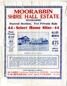 City of Kingston
Pamphlet - Colour, S. M. Reynolds, Estate Agent, Moorabbin Shire Hall Estate Second Section, c. 1930
... Sales plan for land in the suburb of Moorabbin, bounded by South Road and Highbury Street, including Prince Street, Charming Street, Thomas Avenue and Keith Road....Incorporates a map of the estate bordered by South Road and Highbury Street, including Prince Street, Charming Street, Keith Road and Thomas Avenue....City of Kingston Parkdale Library 96 Parkers Road, Parkdale Parkdale Sales plan for land in the suburb of Moorabbin, bounded by South Road and Highbury Street, including Prince Street, Charming Street, Thomas Avenue and Keith Road. ...Sales plan for land in the suburb of Moorabbin, bounded by South Road and Highbury Street, including Prince Street, Charming Street, Thomas Avenue and Keith Road.The developing urban area of Moorabbin within the City of Kingston. This land sale pamphlet illustrates the subdivision of land within the municipality and the changing demographic of the district as new houses are constructed close to infrastructure.Colour pamphlet advertising for private sale the Moorabbin Shire Hall Estate, Moorabbin. Incorporates a map of the estate bordered by South Road and Highbury Street, including Prince Street, Charming Street, Keith Road and Thomas Avenue.Handwritten in grey pencil on subdivision map below subdivision 63: £4 Handwritten in grey pencil on subdivision map below subdivision 66: 4 Handwritten in grey pencil on subdivision map below subdivision 80: 3. Handwritten in grey pencil on subdivision map below subdivision 81: 4 Handwritten in grey pencil on subdivision map below subdivision 83: 2 Handwritten in grey pencil on subdivision map below subdivision 96: £3 Handwritten in grey pencil on subdivision map below subdivision 97: 3 Handwritten in grey pencil on subdivision map to the left of subdivision 102: 3 Handwritten in grey pencil on subdivision map on the corner of Thomas Avenue and Highbury Street: vertical line next to a square with a cross in it.land sales, estate, moorabbin -
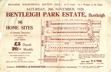 City of Kingston
Pamphlet - Colour, W. H. Wood Estate Agent, Realising sub-divisional auction sale Bentleigh Park Estate, Bentleigh, 1920
... Sales plan for land in the suburb of Bentleigh, bounded by Centre Road, and incorporating subdivisions on either side of Elizabeth Street (Wheatley Road), Oak Street and Beech Street....Incorporates a map of the estate bordered by Centre Road, and including Elizabeth Street (Wheatley Road), Oak Street and Beech Street....City of Kingston Parkdale Library 96 Parkers Road, Parkdale Parkdale Sales plan for land in the suburb of Bentleigh, bounded by Centre Road, and incorporating subdivisions on either side of Elizabeth Street (Wheatley Road), Oak Street and Beech Street. ...Sales plan for land in the suburb of Bentleigh, bounded by Centre Road, and incorporating subdivisions on either side of Elizabeth Street (Wheatley Road), Oak Street and Beech Street.The developing urban area of Bentleigh within the City of Kingston. This land sale pamphlet illustrates the subdivision of land within the municipality and the changing demographic of the district as new houses are constructed close to infrastructure.Colour pamphlet advertising a realising sub-divisional auction sale of the Bentleigh Park Estate, Bentleigh. Incorporates a map of the estate bordered by Centre Road, and including Elizabeth Street (Wheatley Road), Oak Street and Beech Street.Hand drawn in grey pencil: a small square on subdivision 33 Hand drawn in grey pencil: a small square incorporating a cross on subdivision 24 Hand written in black ink on reverse: Bentleigh Park / Estate / Ward late Andersonsland sales, estate, bentleigh -
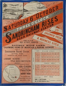 City of Kingston
Pamphlet - Colour, Fergusson & Mitchell Lith, Sandringham Rises, c. 1888
... Sales plan for land in the suburb of Sandringham, bounded by Bluff Road, Bay Road and William Street, and incorporating Frances Street....Incorporates a map of the estate bordered by Bluff Road, Bay Road and William Street, including Frances Street....City of Kingston Parkdale Library 96 Parkers Road, Parkdale Parkdale Sales plan for land in the suburb of Sandringham, bounded by Bluff Road, Bay Road and William Street, and incorporating Frances Street. ...Sales plan for land in the suburb of Sandringham, bounded by Bluff Road, Bay Road and William Street, and incorporating Frances Street.The developing urban area of Highett (then called Sandringham) within the City of Kingston. This land sale pamphlet illustrates the subdivision of land within the municipality and the changing demographic of the district as new houses are constructed close to infrastructure.Colour pamphlet advertising for sale 35 lots in Sandringham Rises, Sandringham. Incorporates a map of the estate bordered by Bluff Road, Bay Road and William Street, including Frances Street.Handwritten in grey pencil next to the words 'THREE O'CLOCK': 1888 Handwritten in blue ben next to the words '& BUSINESS SITES': 1888land sales, sandringham, highett -
 Whitehorse Historical Society Inc.
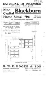
Document, Auction Notice
... Auctions|Molleton Street, Blackburn|Baldwin Road, Blackburn|Main Street, Blackburn...Auction notice for 9 home sites in Molleton Street, Baldwin Road and Main Street, Blackburn...Whitehorse Historical Society Inc. 2-10 Deep Creek Road Mitcham melbourne Auctions|Molleton Street, Blackburn|Baldwin Road, Blackburn|Main Street, Blackburn auction notice for molleton street baldwin road blackburn Auction notice for 9 home sites Auction notice for 9 home sites in Molleton Street, Baldwin Road and Main Street, Blackburn Auction Notice Document Document ...Auction notice for 9 home sitesAuction notice for 9 home sites in Molleton Street, Baldwin Road and Main Street, BlackburnAuction notice for 9 home sitesauction notice for molleton street, baldwin road, blackburn -
 Whitehorse Historical Society Inc.
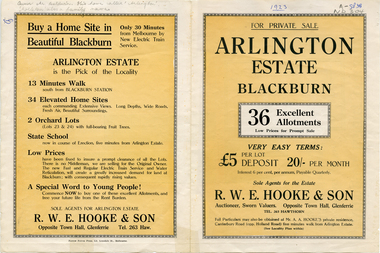
Pamphlet - Advertising brochure, Arlington Estate
... Including Molleton Street. Baldwin Street and Canterbury Road....Estate Agent's advertising brochure for Arlington Estate, Blackburn including Molleton Street. Baldwin Street and Canterbury Road....Baldwin Street and Canterbury Road. arlington estate blackburn molleton street canterbury road baldwin street land subdivision Estate Agent's advertising brochure for Arlington Estate, Estate Agent's advertising brochure for Arlington Estate, Blackburn including Molleton Street. ...Estate Agent's advertising brochure for Arlington Estate,Estate Agent's advertising brochure for Arlington Estate, Blackburn including Molleton Street. Baldwin Street and Canterbury Road.Estate Agent's advertising brochure for Arlington Estate,arlington estate, blackburn, molleton street, canterbury road, baldwin street, land subdivision -
 City of Kingston
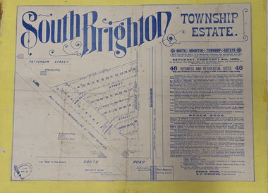
Pamphlet - Colour, Brock Bros, South Brighton Township Estate, 1888
... Sales plan for land in the suburb of South Brighton (Moorabbin), bounded by Point Nepean Road, South Road, Patterson Street and the Mordialloc Railway Line. ...Incorporates a map of the estate bordered by Point Nepean Road, South Road, Patterson Street, and the Mordialloc Railway Line. ...Incorporates a map of the estate bordered by Point Nepean Road, South Road, Patterson Street, and the Mordialloc Railway Line. ...Sales plan for land in the suburb of South Brighton (Moorabbin), bounded by Point Nepean Road, South Road, Patterson Street and the Mordialloc Railway Line. Incorporates Wolsely Street and Gordon StreetThe developing urban area of Moorabbin within the City of Kingston. This land sale pamphlet illustrates the subdivision of land within the municipality and the changing demographic of the district as new houses are constructed close to infrastructure.Colour pamphlet advertising for private sale the South Brighton Township Estate, South Brighton. Incorporates a map of the estate bordered by Point Nepean Road, South Road, Patterson Street, and the Mordialloc Railway Line. Includes Wolsley Street and Gordon Street. land sales, south brighton, estate, moorabbin -
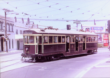 Kew Historical Society Inc
Photograph - W Class 380 turning out of Barkers Road into High Street South, 1990
... Laminated colour enlargement of W Class tram No.380 turning out of Barkers Road into High Street South, during a re-enactment in 1990....W Class 380 turning out of Barkers Road into High Street South"...Photograph W Class 380 turning out of Barkers Road into High Street South ...This colour photograph, with 15 others are enlargements gifted to the Society by Mel Lawrence in 2016. They were taken at a commemorative event from the Kew Tram Depot. Laminated colour enlargement of W Class tram No.380 turning out of Barkers Road into High Street South, during a re-enactment in 1990.Annotation reverse: "Kew Depot 1990. W Class 380 turning out of Barkers Road into High Street South"kew tram depot, trams -- melbourne, a class trams -
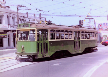 Kew Historical Society Inc
Photograph - Y1 Class 611 in Barkers Road and High Street South, 1990
... Laminated colour enlargement of Y1 Class 611, on the corner of Barkers Road and High Street South, during a re-enactment from the Kew Depot in 1990....Y1 Class 611, turning out of Barkers Road into High Street South"...Photograph Y1 Class 611 in Barkers Road and High Street South ...This colour photograph, with 15 others are enlargements gifted to the Society by Mel Lawrence in 2016. They were taken at a commemorative event from the Kew Tram Depot. Laminated colour enlargement of Y1 Class 611, on the corner of Barkers Road and High Street South, during a re-enactment from the Kew Depot in 1990.Annotation reverse: "Kew Depot 1990. Y1 Class 611, turning out of Barkers Road into High Street South"kew tram depot, trams -- melbourne, y1 class trams -
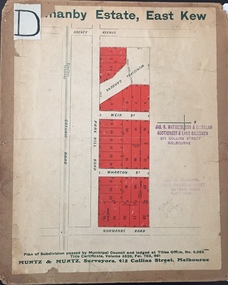 Kew Historical Society Inc
Plan - Subdivision Plan, J R Mathers & McMillan, Normanby Estate, c.1913
... Streets on the subdivision plan include Adeney Avenue, Park Hill Road, Normanby Road, Weir Street and Wharton Street. ...Mathers & Son & McMillan / Auctioneer & Land Salesmen, / 271 Collins Street / Melbourne" and Jas. R. Mathers / Estate & Financial Agent / Cotham Road / Kew"....Streets on the subdivision plan include Adeney Avenue, Park Hill Road, Normanby Road, Weir Street and Wharton Street. ...The Kew Historical Society's map collection includes a substantial number of real estate subdivision plans, mainly of Kew but also of surrounding suburbs in Melbourne. Most of the subdivision plans date from the 1920s and 1930s when the districts old homes and local farmland were being split up to accommodate residential growth in the postwar period. These early plans were assembled by a local firm, Jas R Mather & McMillan, which had an office in Cotham Road. Many of the plans, and sometimes photos, were annotated by the agents.Subdivision plans are historically important documents used as evidence for the growth of suburbs in Australia. They frequently provide information about when the land was sold as well as evidence relating to surveyors and real estate and financial agents. The numerous subdivision plans in the Kew Historical Society's collection represent working documents, ranging from the initial sketches made in planning a subdivision to printed plans on which auctioneers or agents listed the prices for which individual lots were sold. In a number of cases, the reverse of a subdivision plan in the collection includes a photograph of a house that was also for sale by the agent. These photographs provide significant heritage information relating house design and decoration, fencing and household gardens.The photograph may also be aesthetically significant depending on the importance of the photographic atelier.The Normanby Estate, which was adjacent to Normanby Road, Kew East, included thirty-one lots for sale. Streets on the subdivision plan include Adeney Avenue, Park Hill Road, Normanby Road, Weir Street and Wharton Street. Cotham Road and its tramway are shown nearby. The plan is interesting as it shows Wharton Street, named after the architect and town planner George Wharton, who was the first chairman of the Municipality of Kew. The street was to later be renamed Cecil Street. Also shown are proposed ‘Municipal Gardens’ where Parkhill Drive is now located."D" in top left corner. Stamped auctioneers contact details: "Jas. R. Mathers & Son & McMillan / Auctioneer & Land Salesmen, / 271 Collins Street / Melbourne" and Jas. R. Mathers / Estate & Financial Agent / Cotham Road / Kew".weir street - kew, wharton street - kew, normanby road - kew, cotham road - kew, municipal gardens - kew, park hill parkhill road - kew, braemar - kew, subdivision plans - kew -
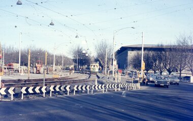 Melbourne Tram Museum
Photograph - Two colour slides - St Kilda Road Trackworks, 1-8-1970
... Set of two colour slides showing the intersection of St Kilda Road, City Road and Sturt Street. City Road at the start of work to lower City Road under St Kilda Road. ...The former tracks into City Road and Sturt Street can be seen in the foreground. .2 - SW6 878 - shows the Arts Centre, YMCA building the intersection with City Road and Sturt Street ...Set of two colour slides showing the intersection of St Kilda Road, City Road and Sturt Street. City Road at the start of work to lower City Road under St Kilda Road. ...Set of two colour slides showing the intersection of St Kilda Road, City Road and Sturt Street. City Road at the start of work to lower City Road under St Kilda Road. The tracks along Sturt Street had been diverted by Nolan Street (now Southbank Blvd). The photo shows that only one of the tracks had been brought into use, the other still under construction. Photography by Warren Doubleday.Yields information on the start of the works to lower City Road under St Kilda Road 1-8-1970Set of two Anscochrome colour slides, of trackwork to place City Road under St Kilda Road. .1 - SW6 959 on St.-Kilda Road deviation - shows the Arts Centre and the scale of the deviation. The former tracks into City Road and Sturt Street can be seen in the foreground. .2 - SW6 878 - shows the Arts Centre, YMCA building the intersection with City Road and Sturt Street Has photographers slide numbers on each slide.trackworks, sturt st, sw6 class, tram 959, tram 878, tramways, track, city road, st kilda road, trams -
Glenelg Shire Council Cultural Collection
Photograph - Photograph - Bridge Construction, 29/05/1957
... Black and white photo of Bridgewater Road (Otway Street) bridge under construction. ...Front: Back- 'Bridgewater road Bridge (otway street) 29/5/57' - pencil...Glenelg Shire Council Cultural Collection History House Cliff Street Portland great-ocean-road Port of Portland Authority Archives Port of Portland Front: Back- 'Bridgewater road Bridge (otway street) 29/5/57' - pencil Black and white photo of Bridgewater Road (Otway Street) bridge under construction. ...Port of Portland Authority ArchivesFront: Back- 'Bridgewater road Bridge (otway street) 29/5/57' - pencilport of portland