Showing 200 items matching " rural members"
-
 Musculoskeletal Health Australia (now held by the Glen Eira Historical Society)
Photograph - Solo photo, Circa 1992 to 1993
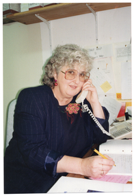
... ... rural members...One of the telephone information services provided to Arthritis Victoria members was the Phone Link service for rural members. This photo depicts staff member, Jan Riley, on the phone at Arthritis Victoria. ...Musculoskeletal Health Australia (now held by the Glen Eira Historical Society) 965 Glen Huntly Road Caulfield melbourne One of the telephone information services provided to Arthritis Victoria members was the Phone Link service for rural members. This photo depicts staff member, Jan Riley, on the phone at Arthritis Victoria. ...One of the telephone information services provided to Arthritis Victoria members was the Phone Link service for rural members. This photo depicts staff member, Jan Riley, on the phone at Arthritis Victoria. The photo was used to promote the Phone Link service to members. A black and white version of this photo appears on page 7 of the 1993 Annual Report with the caption: "Jan Riley, Foundation staff member co-ordinates Arthritis Phone Link."Colour photo of a woman sitting at a desk. She is on the telephone and holding a pen over a notebook. Behind her, there is a wooden shelf attached to the wall with brackets.[On a yellow sticky note, archivist's note handwritten in black ink] from unnamed suspension file (in back of box) PHONE LINK for RURAL Jan Rileyarthritis victoria, av, arthritis foundation of victoria, afv, phone link, rural members, rural and regional, telephone information service, c1990s -
 Wangaratta High School
Victorian Mounted Rifles Shield, 1901
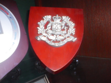
... Formed in 1885, Victorian Mounted Rifles companies were recruited in rural centres, including Wangaratta. Members of country rifle clubs formed a significant component. ...Wangaratta High School 17-49 Edwards Street Wangaratta high-country Formed in 1885, Victorian Mounted Rifles companies were recruited in rural centres, including Wangaratta. Members of country rifle clubs formed a significant component. ...Formed in 1885, Victorian Mounted Rifles companies were recruited in rural centres, including Wangaratta. Members of country rifle clubs formed a significant component. They were semi-professional: only a small allowance was paid to members. Mounted Riflemen were required to provide their own mount. Not to be confused with similarly named contingents to the Boer War. Part of the Victorian Colonial Military Forces - the umbrella term for organized Victorian (non-British) pre-colonial military activity. Red stained and lacquered wood shield with a silver metal Victoria mounted rifles symbol in the centre.VICTORIA MOUNTED RIFLES -
 Kiewa Valley Historical Society
Fire Hose Reel, c1950s
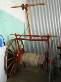
... Mt Beauty was/is an urban brigade whereas Tawonga is a rural brigade. Competition involved members to improve their skill, keep fit and was a very social occasion. ...Mt Beauty was/is an urban brigade whereas Tawonga is a rural brigade. Competition involved members to improve their skill, keep fit and was a very social occasion. ...The fire hose reel was purchased by the Fire Ladies' Auxiliary for the Mt Beauty S.E.C. Fire Brigade in the late 1950's for over 1000 pounds. Initially they competed with Bogong fire brigade as both were 'Industry' Fire brigades - both owned by the State Electricity Commission. Competition was at 2 levels - north east Victoria and state competitions involving rural and urban brigades with a difference in the equipment. Mt Beauty was/is an urban brigade whereas Tawonga is a rural brigade. Competition involved members to improve their skill, keep fit and was a very social occasion. After the Shire took over Mt Beauty township in 1961, the Fire Brigade ran by itself but soon became affiliated with the C.F.A. because of insurance and legal liability e.g.. enabling them to stop traffic or wreck buildings if required. The CFA were not happy with the Mt Beauty truck so a new one was obtained while the old one went to Bogong. Competitions gradually ceased as it was a young man's sport and young members had prior commitments. The reel was donated to the KVHS in the mid 1980's as it failed to be sold as it competed with new, cheaper, aluminium reels. The practice strip was located beside the fire station in Lakeside Avenue. This fire hose reel was used by the Mt Beauty Fire Brigade for demonstrations at competitions during the 1950's and 1960's. The Mt Beauty Fire Brigade Team won the competition in 1966 at Wangaratta. The score was close against the home team and was decided on a play off. The team benefitted by the man who wound the hose on allowing it to end up at the easiest height to handle when full of water and very heavy.The Mt Beauty Fire Brigade was an 'industry' fire brigade belonging to the State Electricity Commission of Victoria from the 1940's. It became a member of the Country Fire Authority in the early 1960's. During the 1950's and early 1960's members would compete with other local fire brigades in competitions against other brigades in the north east of Victoria using skills such as unwinding the hose off the reel and turning on the water in record time. The Mt Beauty Fire Brigade continues today as an urban fire brigade affiliated with the CFA.Varnished wooden cart reinforced by painted red steel frame. The wheels have 14 wooden spokes and steel around the outside of the wooden wheel. A long canvas hose is wound around a central winding cylinder. The cart has a wooden handle with a rubber jockey wheel at its end. There is a brass hose nozzle attached by a stainless steel frame on the outer side near one of the wheels.Each Reel: "Mt Beauty F.B." yellow print outlined in black with red background.fire hose. mt beauty fire brigade. country fire authority. fire reel. -
 Warrnambool and District Historical Society Inc.
Plaque, Artificial Breeders Co-operative, Circa 1965
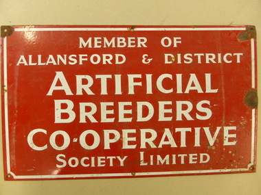
... members with another 100 joining the following year. After a year of coping alone Bill was joined by Ray Eccles from Purnim and then Pat Gleeson, later a Warrnambool car dealer. John Fitzgerald became a part-time technician. These signs were attached to the entrance gates of users. In the mid 1970s it became known as the Warrnambool Co-operative and while it maintained a strong rural...members with another 100 joining the following year. After a year of coping alone Bill was joined by Ray Eccles from Purnim and then Pat Gleeson, later a Warrnambool car dealer. John Fitzgerald became a part-time technician. These signs were attached to the entrance gates of users. In the mid 1970s it became known as the Warrnambool Co-operative and while it maintained a strong rural ...The Allansford Artificial breeders was commenced in 1960 As a business its main focus was on the improvement of local herds for local farmers.As a result of 32 district farmers meeting at the Allansford Mechanics Hall, the Allansford & District Artificial Breeders Co-operative Society was formed. The subscription for membership was £7 10s. The meeting was instigated through the efforts of Noel Garner, a Hopkins Point farmer, who was manager of No.1 and No.2 Warrnambool Herd Testing Associations, and Gethan Fenton, a field officer with the Warrnambool Herd Testing Association. Bill Quinlan, who had been a herd tester under Noel Garner’s management, became the first employee of the Artificial Breeders. WCB support was available from the beginning as a room was provided behind the factory offices and the AI fees were collected by the factory from suppliers’ milk cheques. In the first 12 months Bill worked alone with some assistance from Russell Learmonth and Roger Walsh, both Kraft employees. Both factories realised the benefits of herd improvement in view of their overall increased production so membership was encouraged. Semen from the best sires in Canada and New Zealand were made available and farmers also could soon see the benefits. The initial board of directors, unlike WCB beginnings, consisted entirely of farmers. These included Michael Melican (Wangoom), Gerald Mugavin (Wollaston), Noel Garner (Hopkins Point), Jim Halford (Naringal East) and Grant Warnock (Southern Cross). Membership grew rapidly and after one year there were 164 members with another 100 joining the following year. After a year of coping alone Bill was joined by Ray Eccles from Purnim and then Pat Gleeson, later a Warrnambool car dealer. John Fitzgerald became a part-time technician. These signs were attached to the entrance gates of users. In the mid 1970s it became known as the Warrnambool Co-operative and while it maintained a strong rural and farming focus a opened a retail store in Warrnambool in Timor Street in the 1970's which became the largest trading department store in the district. By the late 1990s they had 8000 members and employed 84 full time and 120 casual staff. It met a sorry end in the 2000's.This sign is a link to a business which had a large exposure in the latter part of the 20th Century. As such it has social and historical significance. Rectangular metal sign, painted red with white text and white border around the edge. Screw holes in corners. Member of Allansford & district Artificial Breeders Co-operative Society Limited allansford artificial breeders, warrnambool co-operative society limited -
 Warrnambool and District Historical Society Inc.
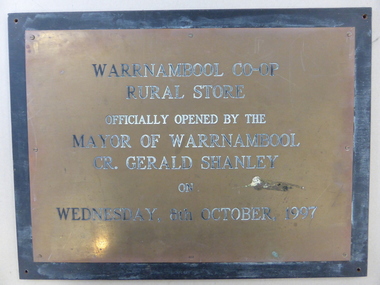
Plaque, Warrnambool Co-op Rural Store, 1997
... In the 1970s they opened a retail store in Timor Street which had a strong rural and farming base which gradually expanded to become the largest trading department store in the district. By the late 1990's they had 8000 members and employed 84 full time and 120 casual staff. ...In the 1970s they opened a retail store in Timor Street which had a strong rural and farming base which gradually expanded to become the largest trading department store in the district. By the late 1990's they had 8000 members and employed 84 full time and 120 casual staff. ...The Warrnambool Co-operative had its beginnings as the Allansford Artificial Breeders Co-operative in the 1960's. In the 1970s they opened a retail store in Timor Street which had a strong rural and farming base which gradually expanded to become the largest trading department store in the district. By the late 1990's they had 8000 members and employed 84 full time and 120 casual staff. It met a sorry end in the 2000's.This plaque commemorates the opening of the Rural store which consolidated the large rural aspect of the business. It opened up the site from Merri Street at the back of the Timor Street building trading in all agricultural products, , chemicals and fuels.A link to one of Warrnambool's largest stores of the latter part of the 20th century and as such it has historical and social significance. Rectangular brass plaque with stamped black text with eight screws around the edge attaching it to a piece of heavy particle board , painted black.Warrnambool Co-Op rural Store officially opened by the Mayor of Warrnambool Cr. Gerald Shanley on Wednesday, 8th October 1997.warrnambool co-operative society limited, warrnambool co-operative rural store, warrnambool -
 Warrnambool and District Historical Society Inc.
Booklet, Hampden League, 2005
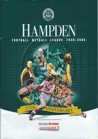
... rural football and netball leagues in Victoria. This publication is of interest as an important source of local information on the history of the Hampden Football Netball League. Football and netball are the two major winter sports in the Western District. Hampden Football Netball League warrnambool Front cover: ‘Hampden Football Netball League 1930-2005, 75th Anniversary, A Special Publication presented by My Town, My Paper, the Standard’. This is an A4 size booklet of 36 pages. It contains black and white and colour photographs, information on each of the member ...This is a publication with information on the Hampden Football Netball League at the time of its 75th anniversary. The Hampden Football League was established in 1930 as a breakaway competition in response to the Western District League’s abolition of sectional competition. The League went into recess during World War Two. In 1987 netball became part of the League’s administration. The Hampden League is one of the important rural football and netball leagues in Victoria. This publication is of interest as an important source of local information on the history of the Hampden Football Netball League. Football and netball are the two major winter sports in the Western District.This is an A4 size booklet of 36 pages. It contains black and white and colour photographs, information on each of the member football and netball teams, the Hampden League logo, advertisements and a multi-coloured front and back cover with collages containing the images of many footballers and netballers. The pages are stapled.Front cover: ‘Hampden Football Netball League 1930-2005, 75th Anniversary, A Special Publication presented by My Town, My Paper, the Standard’. hampden football netball league, warrnambool -
 Kiewa Valley Historical Society
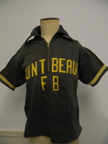
T-Shirt - Mt Beauty Fire Brigade x2
... Mt Beauty rural fire brigade was established in 1948 by the State Electricity Commission of Victoria as an industry brigade. When Mt Beauty was handed over to the Shire in 1961, the fire brigade became a member of the Country Fire Authority (C.F.A.). ...Kiewa Valley Historical Society Mount Beauty Information Centre 31 Bogong High Plains Rd Mt Beauty high-country Mt Beauty rural fire brigade was established in 1948 by the State Electricity Commission of Victoria as an industry brigade. When Mt Beauty was handed over to the Shire in 1961, the fire brigade became a member of the Country Fire Authority (C.F.A.). ...Mt Beauty rural fire brigade was established in 1948 by the State Electricity Commission of Victoria as an industry brigade. When Mt Beauty was handed over to the Shire in 1961, the fire brigade became a member of the Country Fire Authority (C.F.A.). Today it is an urban fire brigade. The t-shirt would have been used when members were together during fire drills, competitions, meetings etc. The black shirt was used prior to 1950 and the Red shirt was used after March 1950 The red t-shirt was used in the following yearThe t-shirt was part of the Mt Beauty fire brigade uniform indicating that the fire fighters were part of a team and were able and wanted to be recognised. It also indicates a strong and popular organisation. Black thick cotton t-shirt with collar and short sleeves. A zip is at the top front. Sleeves have yellow strip near their opening. "Mount Beauty F B" has been zig zagged stitched onto the front, also in yellow. Red thick cotton t-shirt with collar and short sleeves. 2 buttons at the top front. Sleeves have a yellow strip near their opening."Mount / Beauty" has been zig zagged stitched onto the front, also in yellow.Tag inside back under collar - "Sportswear / Simpson / of Melbourne / Mr - then P.A.B. handwritten in space provided. also '36' and 'All cotton' tags attached. Tag inside back under the collar - "Haworth Knit / Glen Iris, Melb./ 100% Cotton"mt beauty; fire brigade; clothing; state electricity commission of victoria -
 Kiewa Valley Historical Society
Photographs – Set of 3 black and white photographs of a building being transported by steam train
... Steam trains were a major form of transport for rural community members prior to the introduction of road transport. ...Prior to the sealing of the Kiewa Valley Highway in 1950, all heavy road stock including building materials, farm equipment and other heavy machinery had to be transported via railway lines to either Albury, Wodonga or Bright and then transported overland for the remainder of the distance by wagon on rough, poorly made roads. Trains also services the mining industries of the Ovens Valley and the transportation of tourists to Mount Buffalo and the very popular Mount Buffalo Chalet.Steam trains were a major form of transport for rural community members prior to the introduction of road transport. Local producers including farmers relied on rail transport to send and receive essential building equipment, farming produce, materials, stock and mail to maintain their lifestyles and social connections with the outside world. 3 black and white photographs of a building being transported by steam train. Photos show the train in three progressively closer photos. Photo shows a man standing in the doorway at the controls of the train, 3 figures, possibly children leaning out of the window of the carriage and another man, standing on the tracks with hands on hips. Photo could have been taken in Tallangatta, Cudgewa or Ebden near Lake Hume where trains were a major form of transport prior to the 1950’s. No markingstransportables; steam train; railway;, old tallangatta, esther temple -
 Kiewa Valley Historical Society
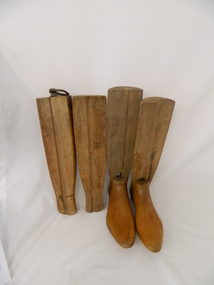
Stocks for Riding Boots, Late 1800's to early 1900's
... rural and outback Australia. The riding stocks "wooden trees" are very significant in the Kiewa Valley because they were used by members of some of the original grazing cattle families to settle there. ...These wooden trees for riding stocks are a concept that was brought to early colonial days from "mother" England. Gentle folk of wealth and status used these trees from early 1800's to keep and maintain their riding boots in their correct form. This form of maintaining the tall riding boot structure was maintained in Australia by the rural "elite" both on cattle properties and smaller cattle stations in the early 1900's. Good riding boots were a status symbol in rural and outback Australia. The riding stocks "wooden trees" are very significant in the Kiewa Valley because they were used by members of some of the original grazing cattle families to settle there. Both cattle and sheep properties occupied large areas of the Kiewa Valley and they also herded their flock and herd on the Bogong High Plains region. These stocks and boots were worn by Fred Roper whose great grand daughter donated them to KVHS. Therefore these boots and stocks would date from 1880's to 1920's and are a good representation of the style of boots worn during this period. This pair of wooden stocks for riding boots trees has been manufactured to a very high standard. Each of the four boot tree parts fit snugly together and maintain their form, and that of the boot that they occupy. The groove channels and foot forms (tongue and groove) are exact and once snapped together become very solid. There is a brass ring, attached by a small brass "peg" on each of the thin "sliding" middle uprights. See KVHS 0177 - Riding boots.On top "L" (for left boot), "R" (for right boot)horse. country. leather. gaiters. high plains. grazing. cattlemen. laces. studs. stocks. roper family. bogong high plains. -
 Kiewa Valley Historical Society
Hookey Board
... The Mt Beauty Rural Fire Brigade was established by the State Electricity Commission of Victoria as an 'industry' brigade. When Mt Beauty was handed over to the Shire in 1961, the Fire Brigade became a member of the Country Fire Authority (C.F.A.). ...This Hookey board was used by the members of the Mt Beauty Rural Fire Brigade from 1948 when the State Electricity Commission established the brigade. ...This Hookey board was made of metal unlike many made of wood. The Mt Beauty Rural Fire Brigade was established by the State Electricity Commission of Victoria as an 'industry' brigade. When Mt Beauty was handed over to the Shire in 1961, the Fire Brigade became a member of the Country Fire Authority (C.F.A.). Today it is an urban fire brigade.This Hookey board was used by the members of the Mt Beauty Rural Fire Brigade from 1948 when the State Electricity Commission established the brigade. Grey metal round board with edge. 13 metal hooks spaced on front with embossed numbers 1 - 13 under each. A small circular engraved brass plaque under No. 13 and between No.s 9 & 10. Metal chain attached at top (for hanging). Embossed "Hookey"between No.s 1 and 13. Embossed numbers 1 - 13. Plaque "C A V .. Sales" on top. "Melbourne" on Bottom. "Quality Products" in middle. Cream paint splash right of centre and slightly on plaque.hookey; mt beauty; rural fire brigade; entertainment; -
 Kiewa Valley Historical Society
Sign - C.W.A. - Country Women's Association
... It is non-sectarian, non-party-political, non profit lobby group working predominantly in the interests of women and children in rural areas. It helps in the provision of services to its members and the improvement of amenities in rural areas....It is non-sectarian, non-party-political, non profit lobby group working predominantly in the interests of women and children in rural areas. It helps in the provision of services to its members and the improvement of amenities in rural areas. ...C.W.A. is the Country Women's Association of Victoria and was formed in 1928. It is a self funded philanthropic organisation. It is non-sectarian, non-party-political, non profit lobby group working predominantly in the interests of women and children in rural areas. It helps in the provision of services to its members and the improvement of amenities in rural areas.The C. W. A. has had branches in the Kiewa Valley up until the present day.Round metal sign. On the front it is green, white and gold. There are four holes in it for attaching it to a fixture eg. Entry to town sign.c.w.a., country women's association -
 Bendigo Military Museum
Souvenir - PLATTER
... member of BCOF in Japan Post War WW2. Items re collection of "RICHARD WILLIAM McGILVERY" RAAF. Refer Cat No. 7287P for his service details, photos and awards. BCOF Souvenir Silver coloured metal platter. Raised edges engraved with decorative flowers and leaves, mostly silver but some red. Small hole at each end. Base engraved with series of rural ...Souvenir collected by a member of BCOF in Japan Post War WW2. Items re collection of "RICHARD WILLIAM McGILVERY" RAAF. Refer Cat No. 7287P for his service details, photos and awards.Silver coloured metal platter. Raised edges engraved with decorative flowers and leaves, mostly silver but some red. Small hole at each end. Base engraved with series of rural images. Back engraved with speckled image and each corner slightly raised.bcof, souvenir -
 Kiewa Valley Historical Society
Petticoat Child
... Mothers and other family members had the seamstress talent to make clothes that are not in full view of anyone Historically these undergarments have no fashion relevance for the younger fashion scene and this garment is an example of the self sufficient supply of home made articles. This was especially so within the Kiewa Valley and surrounds. Fashion in Australia and more so in areas with little or no access to overseas or city merchandise lacked "modern fashionable" clothes e.g. the latest from England and Paris. This region was and still is a rural ...This petticoat is demonstrative of home made infant undergarment clothing in the early 1900. Distance to and from commercial haberdashery store was too far to fit out young girls especially if the are undergarments. Mothers and other family members had the seamstress talent to make clothes that are not in full view of anyoneHistorically these undergarments have no fashion relevance for the younger fashion scene and this garment is an example of the self sufficient supply of home made articles. This was especially so within the Kiewa Valley and surrounds. Fashion in Australia and more so in areas with little or no access to overseas or city merchandise lacked "modern fashionable" clothes e.g. the latest from England and Paris. This region was and still is a rural backdrop of clothes that fit into the type of life and work of the society it holds.Cotton petticoat, white, three buttons on top back, 8mm wide straps of cotton tape. Gathered skirt with triple row of Rick Rack on the bottom edge and three pintucks, 17mm wide, on the lower edge of skirt. Garment is completely hand stitchedchildren's underwear, female underwear, dressmaking, handcraft, costume, clothing -
 Kiewa Valley Historical Society
Bible - Family, Brown's Superb Bible, circa early 1800's to 1900
... rural area" when this bible was first in use. This bible contains as its introduction,scripture history starting from 4004 BC "God created all things" to 2900 AD end of the World. There is a high degree of probability that this bible belonged to a member ...This item represents one of the most important spiritual references available to a settler in countryside Australia in the period 1800s to 1900s. This is the family bible and relates to the major religious beliefs of the early settlers who pioneered British/European colonial settlements. Although the first pages are missing the family name is written on the inside cover (J.A. Fleming). Most of these bibles (of this era) showed the family genealogical record of births, baptism and deaths, however this bible has the relevant pages missing. This bible would have provided the spiritual strength needed in bad times. Throughout this bible there are copies of specially commissioned lithographic engravings, each published between March 1812 to December 1813. These photographs were provided to visualise the theme of the each chapter.This item is significant because it shows that spiritualism of a small group (family in this case) is a vital part of the cohesive forces which holds a family(the basic subgroup of society) together, against all odds, and external pressures. It demonstrates that even in isolated or sparsely populated areas, the mores of a christian community is as strong as that of the cities. Mountains (Victorian Alps) have throughout the enlightened Ages been of extreme spiritual significance and this beholds those who live in this area.The families in the Kiewa Valley fall into the "isolated rural area" when this bible was first in use. This bible contains as its introduction,scripture history starting from 4004 BC "God created all things" to 2900 AD end of the World. There is a high degree of probability that this bible belonged to a member or members of the John Ambrose Flemming extended family who resided in the Kiewa Valley. J.A. Flemming (a famous English electrical engineer and physicist) invented the first diode in 1904). He and his family were devout Christians and he helped establish the Evolution Protest Movement.Leather bound bible. Leather in some areas is in tatters revealing the thick multi-layered cardboard backing. Front and back covers are held together by the thin leather binding. The lettering of the bible is large.Hand written inscriptions are in ink on the inside front cover, " J Tangam" at the top, "J A Fleming" underneath "Tangambalanga" and below that "1900". There are penciled dates "1937 1900" which have at one point in time been scribbled over in pencil. Although not marked on cover, the bible was known as "Brown's Bible" after the Author, the Rev. John Brown. Each of the major chapters is introduced by a copy of a lithographic print detailing the relevant religious picture and all are headed by "Brown's Superb Bible" and the date of the print. bible, rev. john brown, old and new testament, christianity -
 Kiewa Valley Historical Society
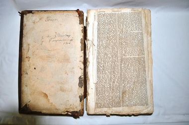
Book - Ledger Commercial, 1902
... The owner of this rural general store was more interested in recording transactions, be it in ink or pencil than the aesthetics of a neat and tidy document. Even though in this era, the principle of neat and tidiness was instilled in workers, this was overlooked and fell away through the economics of employing one staff member to do a variety of tasks for which they may not have had the proper training. ...The owner of this rural general store was more interested in recording transactions, be it in ink or pencil than the aesthetics of a neat and tidy document. Even though in this era, the principle of neat and tidiness was instilled in workers, this was overlooked and fell away through the economics of employing one staff member to do a variety of tasks for which they may not have had the proper training. ...This ledger was started in 1901 when ledgers and other bookkeeping methods were hand written and with nib or fountain pen application. The various ink spots on the pages of this ledger suggests that when the office worker scribed they used the nib and the owner used the fountain pen. It was not until the mid 1950s that ball point pens were discovered and used in rural areas. The owner of this rural general store was more interested in recording transactions, be it in ink or pencil than the aesthetics of a neat and tidy document. Even though in this era, the principle of neat and tidiness was instilled in workers, this was overlooked and fell away through the economics of employing one staff member to do a variety of tasks for which they may not have had the proper training. It was in the early 1900s that the rural areas such as the Kiewa Valley "had to do" with local employees who had basic training but knew their customers very well and were very respectful of age and the mores of the trading public. The respect by shop owners and staff towards their customers was greater in small rural townships and villages within the Kiewa Valley than in the larger towns and cities. Their was no rushing to get the groceries or to spend the least amount of time within the shop. The social interactions where mixed with commercial activities at a very personalised level of one on one. This closeness gave the customer the confidence that those in the commercial transactions in the shop, where looking after them. This ledger is very significant to the Kiewa Valley as it lists the personal transactions of local businesses, farmers, graziers and miners. Larger accounts and other businesses had one or more pages set aside for their transactions. The words are in large freehand (Capitals 5 mm high) possibly to be read by those with poorer eyesight. The relative long distance to travel for reading glasses or specialised optometrist was overcome by writing in larger fonts. The time taken to register produce or other consumables was not critical during the period when this ledger was in use because the local population was not at the critical level where the demand was not as intense as later on when periods of tourist influx became more demanding. The lay back and relaxed attitude of the local population during this period (early 1900s) was not intense and impersonal as within the larger city shopping and commercial environment. The ability of the shop keepers to interact with their customers not only in the commercial sense but also in a social atmosphere permitted the long hand scribbling of purchases without causing any offence.This item is a cloth and suede leather covered ledger.The spine is suede leather with a red stamped "LEDGER" title. The cover is covered with a dark blue cloth and shows a faded unrecognisable pattern. Each page has light blue lines running horizontal and 90 mm apart. Each page has, from the second line going horizontal two fine 1 mm apart red line. Each page is divided horizontally by single vertical line (except for the two double lines in the centre of the page). The first division separates the month from the day.Next to these lines is an area for the description of the item being purchased. Within the central double lines are vertical lines separating the type of tender paid, i.e., pounds, shillings and pence. The last section of the page has various comments, as required by the scribe.Each page is approximately 160 g/ms. The ledger has 698 pages drawn up on both sides and page numbers of 5 mm in height. 'On spine " LEDGER"commerce, book keeping, shop ledger, local history -
 Kiewa Valley Historical Society
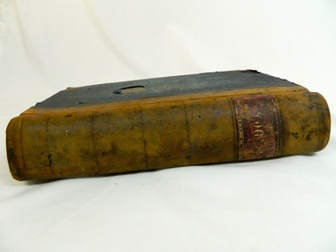
Book - Reference Melbourne Directory, Melbourne and Suburban Directory for 1889, Circa 1889
... Increased populations and greater levels of communication and safe fast transport facilities permitted greater devolution of commercial enterprises into rural communities, such as the Kiewa Valley. state government listings names and location of early melbourne population business names 1889 members of the victorian executive council On the spine in gold colour "South * British insurance Company Fire and Marine. ...This Directory of 1889 covers the location of Melbourne based trade and professional offices by street and in Alphabetical order. It covers all of Melbourne and its suburbs. It also covers government and official, ecclesiastic, legal, municipal and miscellaneous information. The directory details a cross section of a developing city with a splattering of advertisements opening up an in depth look of all aspects of living in the late 1800s. It is interesting to see that all the advertisements do not have any telecommunication numbers listed (personal shoppers or mail orders only). This was a period of high moral standing within the community and hotels advertised rooms " suites of rooms for families and single rooms for Ladies and Gentlemen" also "electric bells throughout the house. Telephone, night porter and hot and cold baths."This directory would be used by the majority of families and businesses working and living within the Kiewa Valley and the surrounding area. Melbourne was the only place where every aspect of living requirement was catered for. Although the delivery of services and goods were not at a high rate, certain items or transactions would require a visit to "the big smoke". Business information are listed both by suburb and alphabetically. There is also a section for British and Foreign Trade. This directory covered nearly everything to do with commerce, an example pay days for principle firms. Greater evolution of trade locations started to balloon out after the mid 1950's. Increased populations and greater levels of communication and safe fast transport facilities permitted greater devolution of commercial enterprises into rural communities, such as the Kiewa Valley.This directory has no front or back cover and is held together by its cloth spine. It contains over 1300 pages, however there may be some pages missing front and back of the directory which would have contained advertisements of some unknown shops. All the sides of this directory (except the spine) have advertisements and content information stamped on. The spine cover has been placed in the directory until further conservation work is carried out. It has gold coloured printing and in the central section, a gold coloured background with the words "Sands & McDougall's Melbourne Directory 1889." The spine has three adverts on the spine.On the spine in gold colour "South * British insurance Company Fire and Marine. Risks Lowest Current Rates No. 11 Queen Street, Arthur J Masters, Manager" and half way down " *Phoenix* Fire Office of London established over 100 years Annual Income exceeds (pound sign) 1,000,000" underneath "Losses Paid Over (pound sign) 16,000,000" underneath "Reserve Fund Exceeds (pound sign) 1,000,000" underneath "9 Market Buildings William Street, Melbourne " underneath " R. Manfield Taylor, Agent" and at the bottom section" Henry Scott Auctioneer and Estate Agent 49 Bridport St., Albert Park" stamped on the bottom side across the page endings "The Wonderful Wertheim Sewing Machines Swanston Street opposite Town Hall", stamped on the top side across the page endings " The Sweet Hapsburg Pianos & Organs Swanston Street Opposite Town Hall"state government listings, names and location of early melbourne population business names, 1889 members of the victorian executive council -
 Kiewa Valley Historical Society
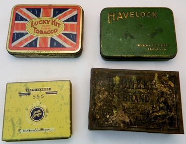
Tins - Tobacco (Lucky Hit) x4, Mid to late 1900s Possibly c1910
... rural social and working mores of the Kiewa Valley. The post war depression (financially) resulted in more smokers turning away from expensive machine (tailor) made cigarettes to the roll your own, using ready rubbed tobacco. This tobacco tin relays a long ago era, when personal contact, and not something that has been written down by some "unknown", was valued as the true appraisal of a member of the community. ...The British Australasian Tobacco Co. (based in Melbourne and Sydney. The parent company was founded in England, circa 1902). This item "Lucky Hit" was the fore runner of the "Lucky Strike" brand name. The ready rubbed tobacco held within the tin was mainly used by those smokers who rolled their own cigarettes. These smokers would have mainly used their palm and formed a cup then placing their choice of the amount of tobacco to be rolled. This would then be placed on the fine cigarette paper and rolled and sealed (using saliva in the mouth) into the required shape. There were mechanical "roll you own" gadgets on the market but most rural users, especially males used their palms. The quantity of tobacco used to make up the cigarette was up to the individual user. The thinner that the cigarette was rolled the longer and more economical did the supply last. The by -products of this method were nicotine stained fingers and hands. "Chain" smokers were easily identified and could therefore be discriminated against obtaining smoke sensitive employment. The two world wars (1914-18 and1939-45) produced a significant rise in the consumption of cigarette use by men and the eventual overflow to women. Cigarette smoking before the 1900s was seen as rough and uncouth (socially frowned upon), however after the introduction of overseas films (U.K. and U.S.A.) and film stars presenting smoking as socially acceptable the rise of smoking cigarettes, especially roll you own (American western movies) in rural areas was an accepted way of life. Things however started to change in the mid 1900s when medical evidence pointed to the health problems of regular smokers. Governments were now implementing non smoking education material. Restrictions on where and when smoking was permitted and acceptable started to creep into all areas of society whether city or rural. This was the era that highlighted the use of roll your own cigarettes, especially when the costs of "tailor made" cigarettes were taxed at an increasing amount. Roll your own cigarettes also provided an avenue for the consumption of illicit drug use.The significance of this ready rubbed tobacco tin to this rural region is, stems from how much influence that the Western novels and overseas films (portraying rural lifestyles) played in shaping the rural social and working mores of the Kiewa Valley. The post war depression (financially) resulted in more smokers turning away from expensive machine (tailor) made cigarettes to the roll your own, using ready rubbed tobacco. This tobacco tin relays a long ago era, when personal contact, and not something that has been written down by some "unknown", was valued as the true appraisal of a member of the community. This was especially relevant in a small regional area such as the Kiewa Valley. Although social networking was not as fast then as the internet provides now, appearances, manners, fashion and etiquette with first impressions high on the order of evaluating someone in the community. Pointer such as the brand of tobacco smoked was part of the rural assessment method. Up until the demise of the Australian Tobacco Industry, circa 2004, the Kiewa Valley and surrounding district was part of a vibrant producer of tobacco leaves. The remnants of this industry still remain today but the drying sheds (for tobacco leaves) are now used to store hay for the valley's dairy and beef cattle industries. Tins 2,3 and 4 were found (in 2009) at Wallace's Hut on the Bogong High Plains. This tobacco tin is constructed from tin plated thin rolled steel. The lid is attached by two pressed and formed (from the main frame) hinges using the nip and tuck construction method. The lid and outside frame have been gold & silver anodised. Tins 2,3 and 4 have the Union Jack on the front lid. One is too rusty to read. The other two have "A blend containing choice selected Australian grown leaf" in white across the bottom on the red border and above the "2oz net weight when packed". In the centre and on the outside of the lid and surrounded by a reproduction of the "Union Jack" is stamped, "Lucky Hit Tobacco" within these words are also stamped "Ready Rubbed". The bottom of the lid is stamped (in smaller script) "2oz NET WEIGHT WHEN PACKED" and underneath this and on the rim of the lid is "THE BRITISH AUSTRALASIAN TOBACCO CO. PTY. LTD. MELBOURNE" on the inside of the lid and stamped in black print on a gold anodised lid is " NOTICE "(underlined) "Every tin of genuine "Lucky Hit has the name of the Manufacturing Company printed on wax paper lining; also on the band or wrapper with which the tin is sealed. THE BRITISH-AUSTRALIAN TOBACCO CO. PTY. LTD., MELBOURNE" and underneath this and underlined is " None genuine without the band or wrapper" On the hinge side of the lid is "LUCKY HIT READY RUBBED TOBACCO" Tins 2,3 and 4 Vary to the above inscription.roll your own, cigarette tins, smoking accessories, personal effects, tobacco containers, tobacco -
 Kiewa Valley Historical Society
Tin Tobacco, Mid to late 1900s
... rural social and working mores of the Kiewa Valley. The post war depression (financially) resulted in more smokers turning away from expensive machine (tailor) made cigarettes to the roll your own, using ready rubbed tobacco. This tobacco tin relays a long ago era, when personal contact, and not something that has been written down by some "unknown", was valued as the true appraisal of a member of the community. ...The British Australasian Tobacco Co. (based in Melbourne and Sydney. The parent company was founded in England, circa 1902). This item "HAVELOCK" is one of many ready rubbed tobacco tins produced by the British Australasian Tobacco Company.The ready rubbed tobacco held within the tin was mainly used by those smokers who rolled their own cigarettes. These smokers would have mainly used their palm and formed a cup then placing their choice of the amount of tobacco to be rolled. This would then be placed on the fine cigarette paper and rolled and sealed (using saliva in the mouth) into the required shape. There were mechanical "roll you own" gadgets on the market but most rural users, especially males used their palms. The quantity of tobacco used to make up the cigarette was up to the individual user. The thinner that the cigarette was rolled the longer and more economical did the supply last. The by -products of this method were nicotine stained fingers and hands. "Chain" smokers were easily identified and could therefore be discriminated against obtaining smoke sensitive employment. The two world wars (1914-18 and1939-45) produced a significant rise in the consumption of cigarette use by men and the eventual overflow to women. Cigarette smoking before the 1900s was seen as rough and uncouth (socially frowned upon), however after the introduction of overseas films (U.K. and U.S.A.) and film stars presenting smoking as socially acceptable, the rise of smoking cigarettes, especially roll you own (American western movies) in rural areas was an accepted way of life. Things however started to change in the mid 1900s when medical evidence pointed to the health problems of regular smokers. Governments were now implementing non smoking education material. Restrictions on where and when smoking was permitted and acceptable started to creep into all areas of society whether city or rural. This was the era that highlighted the use of roll your own cigarettes, especially when the costs of "tailor made" cigarettes were taxed at an increasing amount. Roll your own cigarettes also provided an avenue for the consumption of illicit drug use.The significance of this ready rubbed tobacco tin to this rural region is, stems from how much influence that the Western novels and overseas films (portraying rural lifestyles) played in shaping the rural social and working mores of the Kiewa Valley. The post war depression (financially) resulted in more smokers turning away from expensive machine (tailor) made cigarettes to the roll your own, using ready rubbed tobacco. This tobacco tin relays a long ago era, when personal contact, and not something that has been written down by some "unknown", was valued as the true appraisal of a member of the community. This was especially relevant in a small regional area such as the Kiewa Valley. Although social networking was not as fast then as the internet provides now, appearances, manners, fashion and etiquette with first impressions high on the order of evaluating someone in the community. Pointer such as the brand of tobacco smoked was part of the rural assessment method. Up until the demise of the Australian Tobacco Industry, circa 2004, the Kiewa Valley and surrounding district was part of a vibrant producer of tobacco leaves. The remnants of this industry still remain today but the drying sheds (for tobacco leaves) are now used to store hay for the valley's dairy and beef cattle industries.This tobacco tin is constructed from tin plated thin rolled steel. The lid is attached by two pressed and formed (from the main frame) hinges using the nip and tuck construction method.The lid and outside frame have had a green "weave" pattern anodised to the metal.On the outside of the lid and at the top left is stamped, in gold coloured letters "HAVELOCK". The bottom of the lid is stamped (in smaller script) "READY RUBBED TOBACCO" and below this in smaller lettering "2oz NET WEIGHT WHEN PACKED". On the rim of the lid is "THE BRITISH AUSTRALASIAN TOBACCO CO. PTY. LTD." Inside of the lid and stamped in black print on a gold anodised lid is "Every tin of genuine HAVELOCK Ready Rubbed Tobacco has the mane Havelock printed on the paper lining, and also on the band or wrapping sealing the tin. On the hinge side of the lid is "HAVELOCK READY RUBBED"roll your own, cigarette tins, smoking accessories, personal effects, tobacco containers -
 Kiewa Valley Historical Society
Tin Tobacco / Cigarette, Circa 1900s
... member of the community. This was especially relevant in a small regional area such as the Kiewa Valley. Although social networking was not as fast then as the internet provides now, appearances, manners, fashion and etiquette with first impressions high on the order of evaluating someone in the community. Pointer such as the brand of tobacco smoked was part of the rural ...This particular brand of tobacco (State Express 555) was first made in 1915, and was most popular in Asia and China. The number triple 5 was mooted as a sacred number, and may have contributed to its high level of demand by Asian smokers. This would have been a favourite "smoke" for the Chinese emigrants, and especially those who settled in rural areas of Australia. In the era where 'male' type of activities such as motor racing, were sponsored by tobacco companies, roll your own cigarettes was ingrained as a macho male requirement. It was only in the early 2000s, when cigarette advertising had greater restrictions attached to the product, that the roll your own, and cigarettes in general, became less "cool". This particular cigarette tin would have also been useful for roll your own (ready rub tobacco)The significance of this particular Qantas cigarette tin to this rural region is that it demonstrates that overseas travel by plane was not only for the affluent city dweller but also available, and not impossible to the inhabitants of the Kiewa Valley. This cigarette tin also may hint that the influx of Asian immigrants into this region where able to visit relatives back in Asia without too much effort. The use of a Qantas cigarette tin in the Kiewa Valley also suggests a degree of affluent there or tourists from elsewhere. This tobacco tin relays a long ago era, when personal contact, and not something that has been written down by some "unknown", was valued as the true appraisal of a member of the community. This was especially relevant in a small regional area such as the Kiewa Valley. Although social networking was not as fast then as the internet provides now, appearances, manners, fashion and etiquette with first impressions high on the order of evaluating someone in the community. Pointer such as the brand of tobacco smoked was part of the rural assessment method. Up until the demise of the Australian Tobacco Industry, circa 2004, the Kiewa Valley and surrounding district was part of a vibrant producer of tobacco leaves. The remnants of this industry still remain today but the drying sheds (for tobacco leaves) are now used to store hay for the valley's dairy and beef cattle industries.This tobacco/cigarette tin is constructed from tin plated thin rolled steel. The lid is attached by two pressed and formed (from the main frame) hinges using the nip and tuck construction method.The outside lid and frame has a yellow colour anodised to the metal.On the front of the lid are the following printed: "STATE EXPRESS" ,in yellow print, and below this are two horizontal lines in brown and central to these are the numbers "555" . Below this appears and within a 'royal' crest, in yellow writing on a brown circular background "STATE EXPRESS". Below this, in brown print, "PICCADILLY, LONDON". On each side of the tin are printed in brown colour: front side" ARDATH TOBACCO CO. LTD. PICCADILLY, LONDON" . On the left and right sides are printed in brown colour "20 STATE EXPRESS 555". On the rear side is with smaller print "MANUFACTURED UNDER ARRANGEMENTS WITH THE POPRIETORS". On the inside of the lid printed in red colour, are the following words, the royal crest and sketch of the winged kangaroo(symbol of the QANTAS logo). Within a red elongated square border, are the Royal Crest and in very small red print "BY APPOINTMENT TO HER MAJESTY THE QUEEN" underneath in slightly larger print "STATE EXPRESS" The print underneath this and in smaller print is "CIGARETTE MANUFACTURERS ARDARTH TOBACCO CO. LTD." Next to the royal crest and in much larger print is "STATE EXPRESS" and underneath this ,the numerals 555 with the words "CIGARETTES" below. The lower half of the inside lid has the following words and the "flying" kangaroo(winged). These words in written (running free hand) style "Specially packed for QANTAS(in red print). Underneath and in smaller print is "AUSTRALIA'S OVERSEAS AIRLINE". On the bottom of this tobacco tin is stamped into the metal surface, the number"704"qantas supplied cigarettes, roll your own, cigarette tins, smoking accessories, personal effects, tobacco containers, tobacco -
 Kiewa Valley Historical Society
Tin Tobacco, early to mid 1900s
... member of the community. This was especially relevant in a small regional area such as the Kiewa Valley. Although social networking was not as fast then as the internet provides now, appearances, manners, fashion and etiquette with first impressions high on the order of evaluating someone in the community. Pointer such as the brand of tobacco smoked was part of the rural ...This early tobacco tin was manufactured in England and imported to the "colony" Australia at the beginning of the 1900s. This manufacturer had won the Gold Medal at the Liverpool International Exhibition in 1884. This tobacco would have therefore been very expensive to purchase making it a must for the wealthier client of the Kiewa Valley. The Golden Flake Cavendish smells of the man of wealth and position. In this era the type of dress and the brand of tobacco smoked showed everyone at first glance where the man using it was on the social ladder and his pecking order. With the demise of tobacco smoking in the early 2000s clothes themselves do not show the pecking order in that quickly visualised manner, as at the time of manufacture of this tobacco tin. In the 21st century the level that men are in the socio economic field is realized on "the social information" available on the internet.This tobacco tin relays a long ago era, when personal contact, and not something that has been written down by some "unknown", was valued as the true appraisal of a member of the community. This was especially relevant in a small regional area such as the Kiewa Valley. Although social networking was not as fast then as the internet provides now, appearances, manners, fashion and etiquette with first impressions high on the order of evaluating someone in the community. Pointer such as the brand of tobacco smoked was part of the rural assessment method. Up until the demise of the Australian Tobacco Industry, circa 2004, the Kiewa Valley and surrounding district was part of a vibrant producer of tobacco leaves. The remnants of this industry still remain today but the drying sheds (for tobacco leaves) are now used to store hay for the valley's dairy and beef cattle industries.A dark metal tobacco tin covered in a bright metallic gold fleck pattern with a black frame on the lid around a drawing of a woodsman with a musket and axe sitting on a stump overlooking a valley that reads "Pioneer Brand", next to a company seal incorporating a wreath, eagle and shield. The front side reads "Richmond Cavendish Co./ Limited/ Liverpool." and the right and left side "Golden Flake Cavendish". The bottom has the same woodsman feature as the lid. The back side is an elongated diagram featuring tobacco leaves and plant summit. Inside lid surface has a half torn coloured (red, black and green) sketch on paper of the woodsman scene depicted on the top lid.The following inscriptions are displayed on the top and inside lid and on the bottom tobacco tin: "PIONEER BRAND" and to the left of the scene the "SEAL OF THE COMPANY TRADE MARK" Both side of the ens have the following words in large thick print "GOLDEN FLAKE CAVENDISH" and each is contained withih a black boarder.pipe tobacco, cigarette tins, smoking accessories, personal effects, tobacco containers -
 Emerald Museum & Nobelius Heritage Park
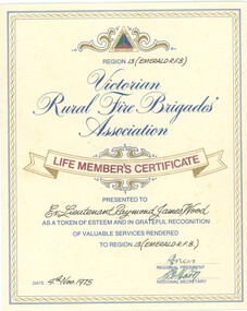
Certificate - Victorian Rural Fire Brigade Association Life Members Certificate - Ex Lieutenant Raymond James Wood (Region 13 Emerald RFB), Victorian Rural Fire Brigade Association, Ex-Lieutenant Raymond James Wood, 4 November 1975
... historical certificate of a member of the Emerald Rural Fire Brigade Association...Image of Life Member Certificate from the Victorian Rural Fire Brigade to Ex Lieutenant Raymond James Wood...Emerald Museum & Nobelius Heritage Park 5 Crichton Rd Emerald yarra-valley-and-the-dandenong-ranges historical certificate of a member of the Emerald Rural Fire Brigade Association historical document related to Emerald CFA CFA VRFBA Certificate signed by officials and dated 4 November 1975 Image of Life Member Certificate from the Victorian Rural Fire Brigade to Ex Lieutenant Raymond James Wood Ex-Lieutenant Raymond James Wood Certificate Victorian Rural Fire Brigade Association Life Members Certificate - Ex Lieutenant Raymond James Wood (Region 13 Emerald RFB) Victorian Rural Fire Brigade Association ...historical certificate of a member of the Emerald Rural Fire Brigade Associationhistorical document related to Emerald CFAImage of Life Member Certificate from the Victorian Rural Fire Brigade to Ex Lieutenant Raymond James WoodCertificate signed by officials and dated 4 November 1975cfa, vrfba -
 Emerald Museum & Nobelius Heritage Park
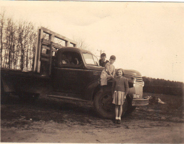
B/W Photograph, 1945
... member of the Nobelius family. The photograph is a record of prominent families in the Emerald district. nobelius family emerald football club hirst FRONT: Truck registration plate VIC FU 947 REAR: Jack Hirst's truck (Jack obscured). John Richardson, Alan Hirst and Elaine Nobelius. 1937 Truck soursed [sic] from Canada. Kodak Print 1215 B/W photograph of three children standing beside a truck belonging to Jack Hirst at a rural ...Jack Hirst owned a property on Paternoster Road, Emerald, where this photograph was taken. He was a general carrier of goods for the district. One of the boys in the photograph is his son. The girl is a member of the Nobelius family.The photograph is a record of prominent families in the Emerald district.B/W photograph of three children standing beside a truck belonging to Jack Hirst at a rural property.FRONT: Truck registration plate VIC FU 947 REAR: Jack Hirst's truck (Jack obscured). John Richardson, Alan Hirst and Elaine Nobelius. 1937 Truck soursed [sic] from Canada. Kodak Print 1215nobelius family, emerald football club, hirst -
 Kiewa Valley Historical Society
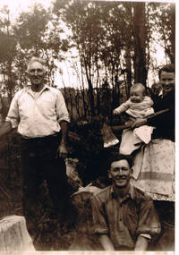
Photograph of Kiewa Valley Pioneer Family, Three Generations of Kiewa Valley Pioneer Family (Coopers), late 1900s'
... The strength of commitment to the rural life can be seen in the faces of the family members in this photograph. ...This historical family photograph spans three generations of the Cooper Family, a pioneer family, still residing in the Kiewa Valley. The large axe held by Pat was a handy tool for pioneer families to chop down trees for land clearing, building sheds and fences, outhouses and fire wood. This photograph was taken during a time where both male and females did some heavy lifting and processing. The rural sector at this point in time was physically a hard location for both sexes. The segregation of the sexes into specific job categories was some times non existent although household "chores" was in the main a woman's domain. The rural sector was in this point of time one which women were highly respected and the unwritten law of providing "assistance" and "reverence" by men in such actions as, socially opening doors, tipping the cap, offering a sturdy arm for support and refraining from doing or saying anything "uncouth" in a woman's presence. It was in a time when women's liberation was just starting to grow strength. Rural areas, on the hole, took longer to interfuse "city" hatched norms of behaviour. This photograph of a pioneer family still residing in the Kiewa Valley demonstrates not only the close protective environment that the valley has on all its inhabitants but also the close bonding that neighbors have towards each other. The term "God's gifted country" fits warmly with all the settlements in the valley. The relatively isolated (physically, visually and communications wise) has since post World War II been whittled away by faster and vastly improved communications with "the outside" world. The strength of commitment to the rural life can be seen in the faces of the family members in this photograph. The proud heritage is displayed without any external pressure. This large black and white family photograph is a reproduction on Fujicolor Crystal Archive Paper manufactured by Fujifilm. It is 200gsm matt finished paper with no borders. On the reverse side, written in pencil "Ted Cooper sitting aged 24-25, Pat Amery (Ted's youngest sister) holding Ted's eldest son Doug and Ted's father John Franklin Cooper(22-8-1892)"john cooper, ted cooper, pat amery, doug cooper, pioneer family kiewa valley -
 Kiewa Valley Historical Society
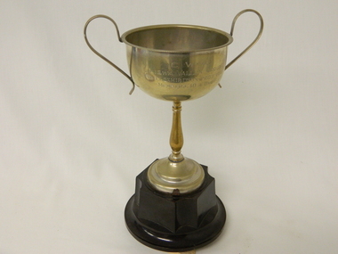
Trophy CWA, Circa 1950
... The Kiewa Valley Group of the C.W.A. was a focal point for women in this still relatively isolated rural region to have a place of refuge from the heavy domestic demands that family and business exerted, and the need of a time and space to gain all the mental relaxation and group bonding necessary to balance the sometimes harsh environment that rural life presented. mementos acknowledgement cwa awards trophies rural women's club "*C W A* KIEWA VALLEY GROUP H & H.I. EXHIBITION-PRIZE FOR MEMBERS. 40 & OVER" Silver plated chalice trophy has two "block ear" type handles fastened at the top lip and going 40mm vertically down to reconnect with the bowl. ...This trophy was presented by the Country Women's Association (C.W.A) Kiewa Valley Branch circa 1950's. This was in a period when the C.W.A. was the major women's organisation which had the greatest influence amongst rural women (especially in isolated areas). This was a period when broad based communications were mainly by radio,women orientated magazines and the telephone. The CWA was an organisation that catered exclusively to women's needs. The atmosphere was one of "sisterhood" and covered nearly all the needs of rural based women. This one organisation incorporated knowledge and learning targeting women who physically may be isolated but not mentally. The C.W.A. motto "Honour our God, Loyalty to the throne, Service to the country, Through country women, For country women, By country women."The Kiewa Valley Group of the C.W.A. was a focal point for women in this still relatively isolated rural region to have a place of refuge from the heavy domestic demands that family and business exerted, and the need of a time and space to gain all the mental relaxation and group bonding necessary to balance the sometimes harsh environment that rural life presented.Silver plated chalice trophy has two "block ear" type handles fastened at the top lip and going 40mm vertically down to reconnect with the bowl. The bowl is connected to the dark brown plastic base by a brass (silver plating has worn off) stem (flower vase shaped).the chalice stem is attached to a circular tapered dome 30mm high which is also silver plated. The plastic base has a 35mm high extension rising from the broader circular bottom section and is rectangular in shape except for the quarter circular indent at each corner. The final circular base provides the chalice with the stability to stand on a flat surface. The whole of the base is hollow allowing the stem fastening nut to be viewed. The inscription on the chalice has been carefully and professionally scribed into the metal. "*C W A* KIEWA VALLEY GROUP H & H.I. EXHIBITION-PRIZE FOR MEMBERS. 40 & OVER" mementos, acknowledgement, cwa awards, trophies, rural women's club -
 Kiewa Valley Historical Society
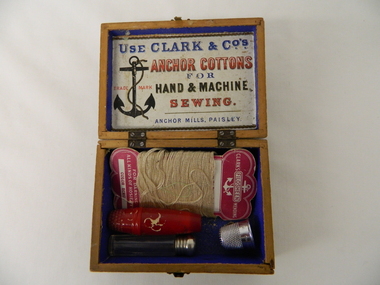
Box Sewing Kit, pre 1952
... member/s. This was at the period where self sufficiency in rural and especially remote areas was a requirement and not just a hobby. ...member/s. This was at the period where self sufficiency in rural and especially remote areas was a requirement and not just a hobby. ...This "sewing and darning" box was purchased before 1952 (the date that the Clark Brothers merged with J&P Coats). It was in an era where the production and alteration/modification to any household or personal clothing was carried out by a family member/s. This was at the period where self sufficiency in rural and especially remote areas was a requirement and not just a hobby. Clothing modifications and "hand me downs" was a way of life. The long and tiresome journey from home to millinery shops was a great force to ensure that home sewing was carried out in the majority of residential and farm areas.This sewing box was donated by a pioneer family in the Kiewa Valley. Its significance points to an era before the establishment of the Kiewa Hydro Electricity Scheme and the establishment of the Mount Beauty Township. It was a time when the rural industries of the Kiewa Valley was rich in production of beef, dairy products, tobacco leaf and before the mass of alpine adventurers that tourism sparked. It was a time rural enterprises out shone tourism.This wooden sewing box is covered with decorative paper. The lid is fastened to the bottom section with two small hinges each having four screws. Each side is fixed to the other by a mortise groove. At the front of the box is a small clasp for complete closure. The box contains needles, darrning thread, thimble, a glass vial with metal screwtop and a red plastic cylindrical container with a thimble screw on top(contains a small reel with three different cotton thread compartments).On outside lid "FROM A FRIEND. I DO NOT WISH THEE GRANDEUR, NOR YET A STORE OF WEALTH, I WISH THEE RICHER TREASURE, CONTENTMENT, PEACE & HEALTH", On inside lid "USE CLARK & CO ANCHOR COTTONS FOR HAND & MACHINE SEWING ANCHOR MILLS, PAISLEY" Each of the different sewing boxes from the Clark Bros. has a label with different "friend" passages.sewing box, hand stitching, domestic clothes alterations, haberdashery -
 Kiewa Valley Historical Society
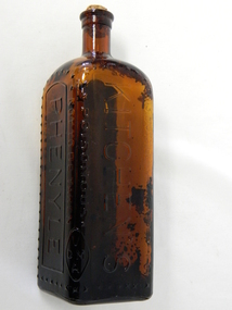
Bottle - Phenyle, Circa 1920
... rural areas, due to the greater distances to hospitals and doctors if contamination occurred. City homes at this time frame had lounge rooms for the daily get together of the family unit. This was an era before the television and computer age fragmented and isolated family members ...Bottled Phenyle cleaner was used throughout the 1900's in domestic kitchens, toilets and other "clean, germ free" environments. Some of these environments would encompass dairying milk handling rooms and hospital kitchens and ablution areas. It is a product which has resulted in the poisoning of some unwitting users (newspaper accounts of a woman in 1928 who drank some phenyle mistakenly for wine and died). The reliance of effective poisonous cleaning products in kitchens, especially in the 1900's was and is still a very hazardous element that the "most pivotal place in a house" contains. In the era when this particular bottle was used (1920's) the main means where consumed around the kitchen table, and this was especially so in rural areas. Keeping this area "germ" free was a mandatory requirement.This bottle is significant to the Kiewa Valley because this area was mostly rural with "out houses" and milk collection areas that required that "extra attention" of sanitation. Rural areas also where more prone to have the kitchen area as a general meeting place for the family before dinner and other meals. Sanitation was of greater importance in rural areas, due to the greater distances to hospitals and doctors if contamination occurred. City homes at this time frame had lounge rooms for the daily get together of the family unit. This was an era before the television and computer age fragmented and isolated family members from one another. This was a time that family members grouped together in the kitchen to find out "the latest news".This amber glass, diamond shaped bottle with cork stopper once contained Phenyle. Phenyle is a highly poisonous liquid. The amber opaque glass was used and not a clear glass to highlight it's content. It has a cork stopper at the top of a slender neck. All the glass embossed writing is highlighted by a string of crosses. The cross was used to enforce a visual danger sign.On one side "THIS BOTTLE IS THE PROPERTY OF" and in large print underneath "KITCHEN'S" and below this and underlined "POISONOUS". On the next side "NOT TO BE TAKEN" and next side in very large print and surrounded by a border "PHENYLE" with crosses enclosing it. On the bottom of a "blank side is "REGd. No. 2140" On the base is M 959 and Mkitchen cleaners, food preparation area, ablutions -
 Federation University Historical Collection
Photograph, The Knuckle at Gippsland Institute of Advanced Education, c1976
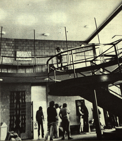
... members of the Gippsland community who are prominent in local government, industry, commerce, education and the professions, the Director of the Institute, and representatives of the academic staff, students, and graduates. On its establishment, the institute assumed responsibility for the diploma courses previously offered by the Yallourn Technical College which had commenced diploma teaching in 1929. Initially, all the Institute's teaching was conducted in the diploma building of the Yallourn Technical College. In 1972 the Institute transferred part of its operations to the first of its permanent buildings on a large campus in rural...members of the Gippsland community who are prominent in local government, industry, commerce, education and the professions, the Director of the Institute, and representatives of the academic staff, students, and graduates. On its establishment, the institute assumed responsibility for the diploma courses previously offered by the Yallourn Technical College which had commenced diploma teaching in 1929. Initially, all the Institute's teaching was conducted in the diploma building of the Yallourn Technical College. In 1972 the Institute transferred part of its operations to the first of its permanent buildings on a large campus in rural ...The Gippsland Institute of Advanced Education was established by an Order-in-Council in September 1968. The Council of the Institute included members of the Gippsland community who are prominent in local government, industry, commerce, education and the professions, the Director of the Institute, and representatives of the academic staff, students, and graduates. On its establishment, the institute assumed responsibility for the diploma courses previously offered by the Yallourn Technical College which had commenced diploma teaching in 1929. Initially, all the Institute's teaching was conducted in the diploma building of the Yallourn Technical College. In 1972 the Institute transferred part of its operations to the first of its permanent buildings on a large campus in rural surrounds near the township of Churchill, ten kilometres south of MOrwell and one hundred and sixty kilometres east of Melbourne. The Gippsland Institute of Advanced Education was opened on 20 November 1976 by the Honourable Lindsay Thompson, Deputy Premier of Victoria and Minister of Education; and Senator J.L. Carrick, Minister for Education in the Commonwealth Government. Image of an area in the Gippsland Institute of Advanced Education known as The Knuckle.gippsland institute of advanced education, gippsland campus collection, the knuckle, churchill -
 Federation University Historical Collection
Photograph, Gippsland Institute of Advanced Education Ampitheatre, c1976
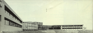
... members of the Gippsland community who are prominent in local government, industry, commerce, education and the professions, the Director of the Institute, and representatives of the academic staff, students, and graduates. On its establishment, the institute assumed responsibility for the diploma courses previously offered by the Yallourn Technical College which had commenced diploma teaching in 1929. Initially, all the Institute's teaching was conducted in the diploma building of the Yallourn Technical College. In 1972 the Institute transferred part of its operations to the first of its permanent buildings on a large campus in rural...members of the Gippsland community who are prominent in local government, industry, commerce, education and the professions, the Director of the Institute, and representatives of the academic staff, students, and graduates. On its establishment, the institute assumed responsibility for the diploma courses previously offered by the Yallourn Technical College which had commenced diploma teaching in 1929. Initially, all the Institute's teaching was conducted in the diploma building of the Yallourn Technical College. In 1972 the Institute transferred part of its operations to the first of its permanent buildings on a large campus in rural ...The Gippsland Institute of Advanced Education was established by an Order-in-Council in September 1968. The Council of the Institute included members of the Gippsland community who are prominent in local government, industry, commerce, education and the professions, the Director of the Institute, and representatives of the academic staff, students, and graduates. On its establishment, the institute assumed responsibility for the diploma courses previously offered by the Yallourn Technical College which had commenced diploma teaching in 1929. Initially, all the Institute's teaching was conducted in the diploma building of the Yallourn Technical College. In 1972 the Institute transferred part of its operations to the first of its permanent buildings on a large campus in rural surrounds near the township of Churchill, ten kilometres south of MOrwell and one hundred and sixty kilometres east of Melbourne. The Gippsland Institute of Advanced Education was opened on 20 November 1976 by the Honourable Lindsay Thompson, Deputy Premier of Victoria and Minister of Education; and Senator J.L. Carrick, Minister for Education in the Commonwealth Government. The Gippsland Institute of Advanced Education ampitheatregippsland institute of advanced education, gippsland campus collection, churchill, ampitheatre, buildings -
 Marysville & District Historical Society
THE TRIANGLE NEWS-VOL 3-NO 33-OCTOBER 20 1978
... members happy birthdays universal children's day can you help? rainfall fruit salad farm tonight is the night crossways restaurant swimming pool caretaker golf senior citizens wanted to buy marysville uniting church old jewellery at the pumpernickel footy club fire brigade retirement of ted carson buxton rural fire brigade kinder roster cricket starts ladies bushwalking THE TRIANGLE NEWS-VOL 3-NO 33-OCTOBER 20 1978 ...marysville, victoria, australia, vicswim, disco, community care centre, stamps, children read this!, girls, christ church ladies guild members, happy birthdays, universal children's day, can you help?, rainfall, fruit salad farm, tonight is the night, crossways restaurant, swimming pool caretaker, golf, senior citizens, wanted to buy, marysville uniting church, old jewellery, at the pumpernickel, footy club, fire brigade, retirement of ted carson, buxton rural fire brigade, kinder roster, cricket starts, ladies bushwalking -
 Orbost & District Historical Society
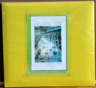
album, Walcott, Judy, Unveiling Hope on McKillops Bridge, 2005
... member. The veiling of McKillops bridge was a 'Year of the Outback' event. The event was organised by Orbost resident, Sr Helen Barnes RSJ. to show solidarity with rural people. ...member. The veiling of McKillops bridge was a 'Year of the Outback' event. The event was organised by Orbost resident, Sr Helen Barnes RSJ. to show solidarity with rural people. ...This album was donated to the Orbost & District Historical Society after the death of Judy Walcott, a long-time member. The veiling of McKillops bridge was a 'Year of the Outback' event. The event was organised by Orbost resident, Sr Helen Barnes RSJ. to show solidarity with rural people. The local community transformed the bridge into "a symbol of communal love and hope", when its sides were draped with hundreds of personal messages. McKillop's Bridge, located high in the Snowy Mountains, is named after George McKillop, a pioneering explorer of the area. The bridge is a vital link for isolated farming communities living beyond the Bonang highway.This album is a useful reference tool.A large photo album with a bright yellow cover and 19 plastic sleeves. It contains photographs, newspaper clippings, brochures , maps and an invitation to the veiling of McKillops Bridge on 8th August 2002. It also contains the history of McKillops Bridge.On inside cover - left hand side - "To Marie with Best Wishes from Judy Walcott 8/8/2005"mckillops-bridge album