Showing 485 items matching " slab"
-
 Stawell Historical Society Inc
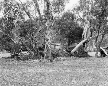
Photograph, Fountain Head Brewery at Armstrong featuring a Slab Hut
... Fountain Head Brewery at Armstrong featuring a Slab Hut...Slab Hut bush scene Brewery Site Fountain Head Brewery at Armstrong. ...Black and white photograph of a slab hut amongst the gum trees in a bush scene....The slab hut is near the cellar but now filled in at Kofoed's Fountain Head Brewery at Armstrong. stawell Black and white photograph of a slab hut amongst the gum trees in a bush scene. ...Slab Hut bush scene Brewery Site Fountain Head Brewery at Armstrong. The slab hut is near the cellar but now filled in at Kofoed's Fountain Head Brewery at Armstrong.Black and white photograph of a slab hut amongst the gum trees in a bush scene.stawell -
 Ballarat Heritage Services
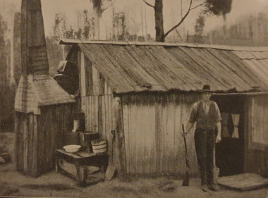
Photograph - Image, A Slab Hut in the Bush, c1918, c1918
... A Slab Hut in the Bush, c1918...Black and white image of a slab hut....Ballarat Heritage Services PO Box 2209 Bakery Hill Post Office goldfields bushman bark hut slab hut Black and white image of a slab hut. ...Black and white image of a slab hut.bushman, bark hut, slab hut -
 Lakes Entrance Historical Society
Photograph - Tourist Information Orbost, M Holding, Slab Hut Orbost Victoria, 1989
... Slab Hut Orbost Victoria...Colour photograph of the Slab Hut Tourist Information Centre Orbost Victoria..Also a second colour photograph of Slab Hut taken from a different angle ...Lakes Entrance Historical Society 4 Marine Parade Lakes Entrance gippsland Tourism Information Colour photograph of the Slab Hut Tourist Information Centre Orbost Victoria..Also a second colour photograph of Slab Hut taken from a different angle Slab Hut Orbost Victoria Photograph Tourist Information Orbost M Holding ...Colour photograph of the Slab Hut Tourist Information Centre Orbost Victoria..Also a second colour photograph of Slab Hut taken from a different angle tourism, information -
 Ballarat Heritage Services
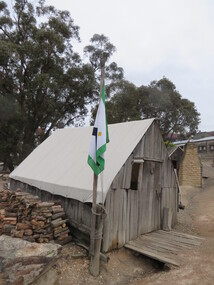
Photograph - Photograph - Colour, Slab Building with Canvas Roof at Sovereign Hill, 2015, 03/03/2015
... Slab Building with Canvas Roof at Sovereign Hill, 2015...Colour photograph of a slab building at Sovereign Hill, Ballarat East....Ballarat Heritage Services PO Box 2209 Bakery Hill Post Office goldfields sovereign hill architecture slab building canvas roof Slab hut Colour photograph of a slab building at Sovereign Hill, Ballarat East. ...Colour photograph of a slab building at Sovereign Hill, Ballarat East.sovereign hill, architecture, slab building, canvas roof, slab hut -
 Orbost & District Historical Society
black and white photograph, first half 20th century
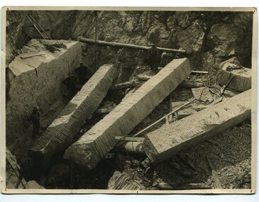
... This photograph shows men cutting marble slabs at Buchan on James Cameron's property. ...A black / white photograph of four men working in a quarry with three large slabs of marble on the ground....on back - " Cutting marble slabs......"...Orbost & District Historical Society Ruskin Street Orbost gippsland This photograph shows men cutting marble slabs at Buchan on James Cameron's property. ...This photograph shows men cutting marble slabs at Buchan on James Cameron's property. The marble was used in the Shrine of REmembrance in Melbourne. The slabs in the photograph were about 8.5 metres long. The Shrine of Remembrance was created to meet the needs of a grieving community after the extensive loss of lives in the First World War (1914 –18). Sixteen dark Ionic columns were made of .Buchan marble In the early 1900s black marble was being mined in the Bruthen district. Some was used for the Shrine of Remembrance in Melbourne and also Australia House in London. 900 tonnes were shipped to London to be included in the construction of Australia House. Marble quarrying has been a significant part of the history of Buchan in East Gippsland. Its inclusion in the Shrine of Remembrance War Memorial is noteworthy.A black / white photograph of four men working in a quarry with three large slabs of marble on the ground.on back - " Cutting marble slabs......"buchan-marble shrine-of-remembrance cameron-james geology -
 Ballarat Heritage Services
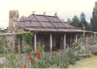
Photograph - Colour, Slab Cottage at Sovereign Hill, 2015, 03/03/2015
... Slab Cottage at Sovereign Hill, 2015...Colour photograph of the Slab cottage at Sovereign Hill, Ballarat East. ...Ballarat Heritage Services PO Box 2209 Bakery Hill Post Office goldfields sovereign hill main road scarred tree slab hut architecture Colour photograph of the Slab cottage at Sovereign Hill, Ballarat East. ...Colour photograph of the Slab cottage at Sovereign Hill, Ballarat East. The tree in the foreground features a scar from bark being removed.sovereign hill, main road, scarred tree, slab hut, architecture -
 Lakes Entrance Historical Society
Photograph - Information Centre Orbost Victoria, Water wheel and stamper installed near the Slab Hut, 1989 c
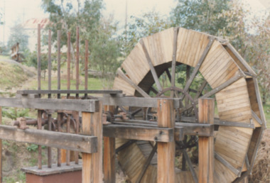
... Water wheel and stamper installed near the Slab Hut ...Colour photograph of the water wheel installed near the Slab Hut at Information Centre Orbost Victoria. ...Also nother photo of water wheel Water wheel and stamper installed near the Slab Hut Photograph Information Centre Orbost Victoria ...Colour photograph of the water wheel installed near the Slab Hut at Information Centre Orbost Victoria. Also nother photo of water wheelcelebrations, people -
 Stawell Historical Society Inc
Photograph, Mr William Currie & Mrs Mary Ann Currie nee Unknown in front of their Timber Slab Home c1910
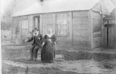
... Mr William Currie & Mrs Mary Ann Currie nee Unknown in front of their Timber Slab Home c1910...William & Mary Ann Currie in front of Slab Home c1910...Stawell Historical Society Inc 46 Longfield St Stawell grampians William & Mary Ann Currie in front of Slab Home c1910 Stawell House Mr William Currie & Mrs Mary Ann Currie nee Unknown in front of their Timber Slab Home c1910 Photograph ...William & Mary Ann Currie in front of Slab Home c1910stawell house -
 Stawell Historical Society Inc
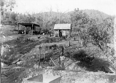
Photograph, Telford Mining activity with a Slab shed and work area in the Bushland c1902
... Telford Mining activity with a Slab shed and work area in the Bushland c1902...Telford Mining activity Slab shed and work area in Bushland c1902...Stawell Historical Society Inc 46 Longfield St Stawell grampians Telford Mining activity Slab shed and work area in Bushland c1902 Stawell Gold Telford Mining activity with a Slab shed and work area in the Bushland c1902 Photograph ...Telford Mining activity Slab shed and work area in Bushland c1902stawell gold -
 Heidelberg Golf Club
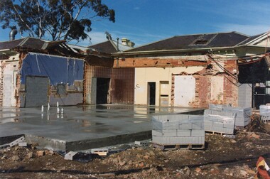
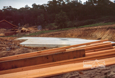
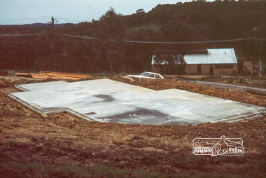
Photograph, Heidelberg Golf Club: Clubhouse renovations 1997-98 - concrete slab for new Pro Shop, 1997
... Heidelberg Golf Club: Clubhouse renovations 1997-98 - concrete slab for new Pro Shop...Heidelberg Golf Club: Clubhouse renovations 1997-98 - concrete slab Pro Shop ...Heidelberg Golf Club 8 Main Road Lower Plenty 3093 Heidelberg Golf Club: Clubhouse renovations 1997-98 - concrete slab Pro Shop Clubhouse redevelopment 1998 HGC Clubhouse 1997 Bryn Teg Pro Shop Colour photograph and caption, in album Heidelberg Golf Club: Clubhouse renovations 1997-98 - concrete slab for new Pro Shop Photograph Photograph ...Heidelberg Golf Club: Clubhouse renovations 1997-98 - concrete slab Pro Shop Colour photograph and caption, in albumclubhouse redevelopment 1998, hgc clubhouse 1997, bryn teg, pro shop -
 Glenelg Shire Council Cultural Collection
Photograph - Photograph - Alcoa Berth, Port of Portland, 1980
... ... slab...Black & white photo showing the pouring of a concrete slab. There are 2 men on the left, one with a shovel. ...Back: Pouring Pre-cast slabs - ALCOA BERTH Sept 1980 - pencil bottom right....Glenelg Shire Council Cultural Collection History House Cliff Street Portland great-ocean-road Port of Portland Authority Archives Port of Portland Archives Alcoa Berth slab concrete construction construction worker Back: Pouring Pre-cast slabs - ALCOA BERTH Sept 1980 - pencil bottom right. ...Port of Portland Authority ArchivesBack: Pouring Pre-cast slabs - ALCOA BERTH Sept 1980 - pencil bottom right.port of portland archives, alcoa berth, slab, concrete, construction, construction worker -
 Stawell Historical Society Inc
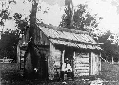
Photograph, Original Borough Hut of Wood slab construction with bark roof for the Stawell Water Supply
... Original Borough Hut of Wood slab construction with bark roof for the Stawell Water Supply ...Stawell Water Supply Borough Hut. Wood slab construction with bark roof. Original Borough Hut....Stawell Original Borough Hut of Wood slab construction with bark roof for the Stawell Water Supply Photograph ...Stawell Water Supply Borough Hut. Wood slab construction with bark roof. Original Borough Hut.stawell -
 Stawell Historical Society Inc
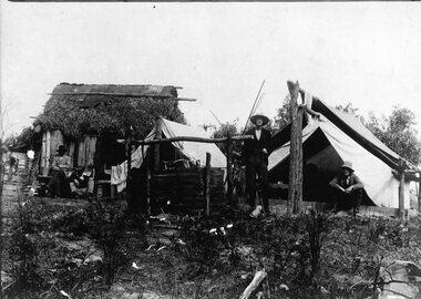
Photograph, Telford Langwarrin Camp Scenes -- Mr W.W. Telford standing with Mr R.M. Telford in front of Tent & Mr W. & Mr R. Mitchell in front of Slab Hut
... Mitchell in front of Slab Hut...Mitchell in front of Slab Hut....Mitchell in front of Slab Hut Photograph ...Telford Langwarrin Camp Scenes. W.W. Telford Standing. R.M. Telford in front of Tent. W. & R. Mitchell in front of Slab Hut. -
 Greensborough Historical Society
Photograph - Digital image, Marilyn Smith et al, Janefield Precinct: View of slab from below showing formwork marks, 27/11/2014
... Janefield Precinct: View of slab from below showing formwork marks....Janefield Precinct: View of slab from below showing formwork marks. The remains of this site are between Greensborough and Janefield. ...Janefield Precinct: View of slab from below showing formwork marks. Photograph - Digital image Marilyn Smith Norm Colvin ...Janefield Precinct: View of slab from below showing formwork marks. The remains of this site are between Greensborough and Janefield. A RAAF Hygiene Training Camp was located on the Plenty River, just south of the Janefield community. It was in use from 1944 to 1946. The Camp was constructed from salvaged materials. Instruction included building and maintenance of grease traps, latrines, elementary plumbing and carpentry.Early remains of a WW2 training camp Digital colour photograph.janefield -
 Eltham District Historical Society Inc
Photograph, Slab hut, Warrandyte, Warrandyte Mystery Tour, 29 May 1994, 29/05/1994
... Slab hut, Warrandyte, Warrandyte Mystery Tour, 29 May 1994...Still on this side of the river we visited the Old Slab Hut in Castles Road. This remnant of miners' housing is preserved because it had been incorporated into a weatherboard house, and saved from the bulldozers - a last minute reprieve, for preservation, by the National Trust. ...A great day for all concerned - many thanks to the Organisers. slab hut warrandyte "warrandyte miner's cottage" Colour photograph Slab hut, Warrandyte, Warrandyte Mystery Tour, 29 May 1994 Photograph ...[article by Bettina Woodburn in EDHS Newsletter No. 97, July 1994:] THE WARRANDYTE MYSTERY TOUR MAY 29TH 1994 - Members of the Eltham Historical Society met at the Old Post Office, now converted into the Warrandyte Historical Museum, for a picnic lunch on the sunny back verandah overlooking the shimmering Yarra River. Interesting photographs and artefacts filled various rooms outlining the history of this area, and told tales of Aboriginal and more recent neighbours of the Eltham Shire. The weather was calm, cloudy mostly with only occasional sunny patches, but it wasn't cold, although the autumnal leaf colours had changed to wintry brown. "All Aboard" and we set off in the Warrandyte Community Bus (with the School Bus sign displayed at the rear) to learn about local places of "Pride and Joy” from Bruce our guide and Tom the driver. Almost directly opposite we entered Whipstick Gully to explore the first of the district's hidden treasures - the Victory, one of the largest of the six or so major mines, past the old quarry now used for abseiling practice. By torchlight we entered the rocky hillside and saw the seams of quartz the miners had followed in their search for gold. Stamping batteries, and there was one in this gully, converted discarded rock into 'road metal'. Warrandyte is proud to be the first declared Goldfield in 1851, and one of the longest surviving, into the 1920s. A pleasant drive across the Bridge and along Bradley's Lane to Norman's Reserve brought us to see another Tunnel at Pound Bend through which the Yarra was diverted to allow about three miles of river-bed to be used for prospecting for alluvial gold. Still on this side of the river we visited the Old Slab Hut in Castles Road. This remnant of miners' housing is preserved because it had been incorporated into a weatherboard house, and saved from the bulldozers - a last minute reprieve, for preservation, by the National Trust. Devastating bush fires have destroyed other old cottages built of wattle and daub, with bark roofs and stone fire-places. The Cairn commemorating the disclosure of Gold Discovery at Warrandyte on June 30th 1851 beside Anderson's Creek Road was our next point of historical interest. We drove on to South Warrandyte and circled back to above the ford on Anderson's Creek to the entrance of the 4th Hill Mine. Again we crept along with our torches, careful of the low roof-rock, and side shafts. At a junction in a large cavity we were able to stand, look up a long air-vent which some 'cavers' climb down, and marvel at, and experience an aspect of a miner's life. Outside we heard the same bird songs, the trills and bell-pealing, saw the same straggly eucalypts, and a silver leafed wattle in flower, native grasses and ferns, and the neat present day houses, often of Warrandyte stone, perhaps veneered only. The day ended pleasantly, seeing more of the Yarra from Everard Drive, and the water rushing out of the Tunnel at Pound Bend, before returning to afternoon tea or coffee at the Museum. A great day for all concerned - many thanks to the Organisers.Colour photographslab hut, warrandyte, "warrandyte miner's cottage" -
 Orbost & District Historical Society
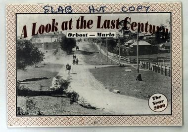
calendar, A Look at the Last Century, 2000
... The calendar was produced as a souvenir of the Orbost/Marlo area for sale in the Orbost Visitor Information Centre, The Slab Hut....SLAB HUT COPY at the top in black....Orbost & District Historical Society Ruskin Street Orbost gippsland The calendar was produced as a souvenir of the Orbost/Marlo area for sale in the Orbost Visitor Information Centre, The Slab Hut. This is a photographic souvenir of Orbost and is a good research tool. history-orbost photographs SLAB HUT COPY at the top in black. ...The calendar was produced as a souvenir of the Orbost/Marlo area for sale in the Orbost Visitor Information Centre, The Slab Hut.This is a photographic souvenir of Orbost and is a good research tool.A calendar for the year 2000. It contains b/w photographs of the Orbost district and is titled, "A Look at the Last Century" Orbost-Marlo. On the front cover is a photograph "Main Road into Town 1917". It shows "Hoffman's paddock and Herbert's Bulk Store and Bakery.SLAB HUT COPY at the top in black.history-orbost photographs -
 Eltham District Historical Society Inc
Photograph, Concrete slab from backyard
... Concrete slab from backyard...It was one of the earliest estates in Eltham following the nearby Woodridge Estate development. stokes place eltham stokes orchard stokes orchard estate streets houses peter and carla vermey Scanned by EDHS from 49 x 35mm colour transparencies provided on loan Digital file Concrete slab from backyard Photograph ...14 Stokes Place (Lot 83) was the home of Peter and Carla Vermey. The land was purchased in May 1979 and construction commenced September 1979. The home was built by Peter and Carla Vermey after the developer, Macquarie Builders went bankrupt. Sold October 2017 by Morrison and Kleeman Real Estate. Stokes Place was part of the Stokes Orchard Estate which was developed from the break-up of the the orchard owned by Frank Stokes who lived on the northeast corner of Nyora Road and Eucalyptus Road. His daughter Beryl advised that the Shire had levied a rate assessment on individual parcels of land within the orchard which became unaffordable resulting in its sub-division and sell off. The Stokes Orchard Estate was developed by Macquarie Builders in two stages starting with stage 1 in 1976. Stokes Place was part of Stage 2 in 1979. The Estate was bounded between Nyora Road, Eucalyptus Road, Diosma Road and Stokes Place. The original orchard only just reached the left most portions of Stokes Place and did not go fully up to Diosma, rather to just beyond the extant of Stokes Place. Stokes Place was known within the family as "The Oats" as that is where they grew oats. Frank Stokes moved to Eltham c.1945 after visiting Harold Bird to view his orchard, located diagonally opposite Stokes Orchard from the intersection of Eucalyptus Road, Pitt Street and Nyora Road. It was on Harold Bird's recommendation that Frank purchased the land.The Stokes Orchard Estate collection is typical of housing developments of the late 1970s and 1980s. It was one of the earliest estates in Eltham following the nearby Woodridge Estate development.Digital fileScanned by EDHS from 49 x 35mm colour transparencies provided on loanstokes place, eltham, stokes orchard, stokes orchard estate, streets, houses, peter and carla vermey -
 Eltham District Historical Society Inc
Photograph, Concrete slab from driveway
... Concrete slab from driveway...It was one of the earliest estates in Eltham following the nearby Woodridge Estate development. stokes place eltham stokes orchard stokes orchard estate streets houses peter and carla vermey Scanned by EDHS from 49 x 35mm colour transparencies provided on loan Digital file Concrete slab from driveway Photograph ...14 Stokes Place (Lot 83) was the home of Peter and Carla Vermey. The land was purchased in May 1979 and construction commenced September 1979. The home was built by Peter and Carla Vermey after the developer, Macquarie Builders went bankrupt. Sold October 2017 by Morrison and Kleeman Real Estate. Stokes Place was part of the Stokes Orchard Estate which was developed from the break-up of the the orchard owned by Frank Stokes who lived on the northeast corner of Nyora Road and Eucalyptus Road. His daughter Beryl advised that the Shire had levied a rate assessment on individual parcels of land within the orchard which became unaffordable resulting in its sub-division and sell off. The Stokes Orchard Estate was developed by Macquarie Builders in two stages starting with stage 1 in 1976. Stokes Place was part of Stage 2 in 1979. The Estate was bounded between Nyora Road, Eucalyptus Road, Diosma Road and Stokes Place. The original orchard only just reached the left most portions of Stokes Place and did not go fully up to Diosma, rather to just beyond the extant of Stokes Place. Stokes Place was known within the family as "The Oats" as that is where they grew oats. Frank Stokes moved to Eltham c.1945 after visiting Harold Bird to view his orchard, located diagonally opposite Stokes Orchard from the intersection of Eucalyptus Road, Pitt Street and Nyora Road. It was on Harold Bird's recommendation that Frank purchased the land.The Stokes Orchard Estate collection is typical of housing developments of the late 1970s and 1980s. It was one of the earliest estates in Eltham following the nearby Woodridge Estate development.Digital fileScanned by EDHS from 49 x 35mm colour transparencies provided on loanstokes place, eltham, stokes orchard, stokes orchard estate, streets, houses, peter and carla vermey -
 Eltham District Historical Society Inc
Photograph, Concrete slab from north elevation
... Concrete slab from north elevation...It was one of the earliest estates in Eltham following the nearby Woodridge Estate development. stokes place eltham stokes orchard stokes orchard estate streets houses peter and carla vermey Scanned by EDHS from 49 x 35mm colour transparencies provided on loan Digital file Concrete slab from north elevation Photograph ...14 Stokes Place (Lot 83) was the home of Peter and Carla Vermey. The land was purchased in May 1979 and construction commenced September 1979. The home was built by Peter and Carla Vermey after the developer, Macquarie Builders went bankrupt. Sold October 2017 by Morrison and Kleeman Real Estate. Stokes Place was part of the Stokes Orchard Estate which was developed from the break-up of the the orchard owned by Frank Stokes who lived on the northeast corner of Nyora Road and Eucalyptus Road. His daughter Beryl advised that the Shire had levied a rate assessment on individual parcels of land within the orchard which became unaffordable resulting in its sub-division and sell off. The Stokes Orchard Estate was developed by Macquarie Builders in two stages starting with stage 1 in 1976. Stokes Place was part of Stage 2 in 1979. The Estate was bounded between Nyora Road, Eucalyptus Road, Diosma Road and Stokes Place. The original orchard only just reached the left most portions of Stokes Place and did not go fully up to Diosma, rather to just beyond the extant of Stokes Place. Stokes Place was known within the family as "The Oats" as that is where they grew oats. Frank Stokes moved to Eltham c.1945 after visiting Harold Bird to view his orchard, located diagonally opposite Stokes Orchard from the intersection of Eucalyptus Road, Pitt Street and Nyora Road. It was on Harold Bird's recommendation that Frank purchased the land.The Stokes Orchard Estate collection is typical of housing developments of the late 1970s and 1980s. It was one of the earliest estates in Eltham following the nearby Woodridge Estate development.Digital fileScanned by EDHS from 49 x 35mm colour transparencies provided on loanstokes place, eltham, stokes orchard, stokes orchard estate, streets, houses, peter and carla vermey -
 Narre Warren and District Family History Group
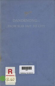
Book, Jean Uhl, Dandenong - from slab hut to city, 1976
... Dandenong - from slab hut to city...This is a reprint of that article. 22 cm Dandenong - from slab hut to city Book Jean Uhl ...This short history of Dandenong covering the period from 1836 - 1959 was originally written for a competition organised by the Royal Historical Society of Victoria in 1960 and was first published in the Victorian History Magazine, vol 34(2), November 1963. This is a reprint of that article.22 cmnon-fictionThis short history of Dandenong covering the period from 1836 - 1959 was originally written for a competition organised by the Royal Historical Society of Victoria in 1960 and was first published in the Victorian History Magazine, vol 34(2), November 1963. This is a reprint of that article. dandenong (vic.), dandenong (vic.) - history -
Dandenong & District Historical Society
Book, Dandenong From Slab Hut to City
... Dandenong From Slab Hut to City...Dandenong & District Historical Society 1st Floor, 39 Clow Street Dandenong melbourne Dandenong From Slab Hut to City Book ... -
 Inverloch Historical Society
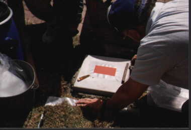
001229 Photograph - January 1998 - Bass Bicentenary Time Capsule - Levelling plaque slab - from P Jones
... 001229 Photograph - January 1998 - Bass Bicentenary Time Capsule - Levelling plaque slab - from P Jones...Inverloch gippsland 001229 Photograph - January 1998 - Bass Bicentenary Time Capsule - Levelling plaque slab - from P Jones ... -
 Orbost & District Historical Society
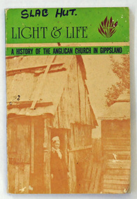
book, Light & Life, c 1997
... This book was a Slab Hut display item. It was published to mark the 75th anniversary of the Anglican diocese of Gippsland....On front cover in black print - SLAB HUT....Orbost & District Historical Society Ruskin Street Orbost gippsland This book was a Slab Hut display item. It was published to mark the 75th anniversary of the Anglican diocese of Gippsland. ...This book was a Slab Hut display item. It was published to mark the 75th anniversary of the Anglican diocese of Gippsland.This book is a useful reference on the history of the Anglican church in Gippsland.A paperback book, titled "Light & Life a History of the Anglican church in Gippsland. It was compiled by I.T. Maddern. The front and back cover has a sepia photograph of a woman standing outside a bark hut. The book contains b/w photographs of churches an d clergy of the Gippsland Anglican churches until 1977.. On the back cover is the emblem of the diocese.On front cover in black print - SLAB HUT.book-light-&-life anglican-church-gippsland history-churches-gippsland -
 Orbost & District Historical Society
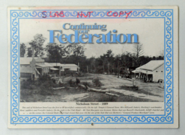
calendar, Snowy River Mail, Continuing Our Federation, 2001
... This item was used in the Slab Hut (Orbost Visitor Information Centre)....on front cover -"SLAB HUT COPY" in red felt tip pen....Orbost & District Historical Society Ruskin Street Orbost gippsland This item was used in the Slab Hut (Orbost Visitor Information Centre). ...This item was used in the Slab Hut (Orbost Visitor Information Centre).This item is a useful pictorial reference tool on the history of Orbost.A 2002 stapled calendar, titled "Continuing Our Federation".On the front is a black/white photograph of the main street of Orbost. It has blue print and an ornate blue frame. It contains photographs of earl Orbost, one for each month. on front cover -"SLAB HUT COPY" in red felt tip pen.calendar-continuing -our-federation photographs-historic-orbost -
Glenelg Shire Council Cultural Collection
Photograph - Photograph - Alcoa berth, Portland Harbour, 1981
... Black & white photo showing two men leveling off a concrete slab. Another man standing with his back to them. ...Back: PRE-CAST DECK SLABS 4 ALCOA WHARF 8.1.81 - pencil...Glenelg Shire Council Cultural Collection History House Cliff Street Portland great-ocean-road Port of Portland Authority Archives Port of Portland Archives Alcoa Berth silos Portland Harbour Trust Back: PRE-CAST DECK SLABS 4 ALCOA WHARF 8.1.81 - pencil Black & white photo showing two men leveling off a concrete slab. ...Port of Portland Authority ArchivesBack: PRE-CAST DECK SLABS 4 ALCOA WHARF 8.1.81 - pencilport of portland archives, alcoa berth, silos, portland harbour trust -
Glenelg Shire Council Cultural Collection
Photograph - Photograph - Portland Harbour, n.d
... ... slab...Black & white photo of concrete slabs being manoeuvred into place by four workmen at Berth No. 6, Portland....Glenelg Shire Council Cultural Collection History House Cliff Street Portland great-ocean-road Port of Portland Authority Archives Port of Portland Archives berth 6 construction concrete slab Black & white photo of concrete slabs being manoeuvred into place by four workmen at Berth No. 6, Portland. ...Port of Portland Authority Archivesport of portland archives, berth 6, construction, concrete, slab -
Glenelg Shire Council Cultural Collection
Photograph - Photograph - construction, Portland Harbour, 1981
... Black & white photo showing concrete being poured from a chute into a prepared slab. There are 3 men in shorts and rubber boots using shovels to spread the concrete. a fourth man, partly obscured by the chute, is standing beside the concrete truck....Back: PRE-CAST SLABS 4 ALCOA WHARF DECK 8/1/81...Glenelg Shire Council Cultural Collection History House Cliff Street Portland great-ocean-road Port of Portland Authority Archives Port of Portland Archives construction concrete slbs truck Portland Harbour Back: PRE-CAST SLABS 4 ALCOA WHARF DECK 8/1/81 Black & white photo showing concrete being poured from a chute into a prepared slab. ...Port of Portland Authority ArchivesBack: PRE-CAST SLABS 4 ALCOA WHARF DECK 8/1/81port of portland archives, construction, concrete, slbs, truck, portland harbour -
 Orbost & District Historical Society
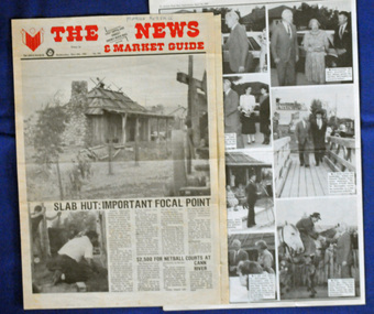
newspaper clippings, April, May 1987
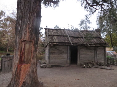
... The Slab Hut (Orbost Visitor Information Centre) was opened on March 28, 1987. ...All relate to the opening of the Slab Hut, the Orbost Visitor Information Centre. ...Orbost & District Historical Society Ruskin Street Orbost gippsland The Slab Hut (Orbost Visitor Information Centre) was opened on March 28, 1987. ...The Slab Hut (Orbost Visitor Information Centre) was opened on March 28, 1987. It was officially opened by Dr D. Caughey, the governor of Victoria. The Orbost Visitor Information Centre is situated in Forest Park on Nicholson Street. The centre is housed in the historic Slab Hut. The hut was an original family dwelling built in 1872, on a site approximately three kilometres upstream from the junction of the Buchan and Snowy Rivers. The Hut was removed from its original site around 1970, and stored until 1984 when the Shire Council approved the current site. It was restored and brought to life as a Tourist Information Centre in 1987.The Slab Hut is an icon of Orbost. These newspaper articles are contemporary records of the opening of this building.A selection of articles from The News and the Snowy River Mail. All relate to the opening of the Slab Hut, the Orbost Visitor Information Centre. They are photographs, information and the history of the Slab Hut.slab-hut-orbost newspaper-snowy-river-mail -
 Orbost & District Historical Society
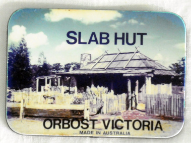
souvenir, C 1980's
... Possibly made and distributed via the Slab Hut (Orbost Visitor Information Centre) in 1980's/1990's....A small flat rectangular fridge magnet with a colour photograph of the Slab Hut (Orbost Visitor Information Centre) on one side. ...Possibly made and distributed via the Slab Hut (Orbost Visitor Information Centre) in 1980's/1990's. ...Used as a tourist souvenir of Orbost. Possibly made and distributed via the Slab Hut (Orbost Visitor Information Centre) in 1980's/1990's.The souvenir is an important component of the tourist experience with most tourists bringing back mementos and souvenirs as evidence. Fridge magnets are popular as souvenir and promotional items because they are relatively cheap to manufacture and very portable for tourists. This item is an example of a typical souvenir of Orbost. A small flat rectangular fridge magnet with a colour photograph of the Slab Hut (Orbost Visitor Information Centre) on one side. The other side is grey/black, At the top of the coloured side is "SLAB HUT" and below is "ORBOST VICTORIA made in Australia".souvenir-orbost fridge-magnet -
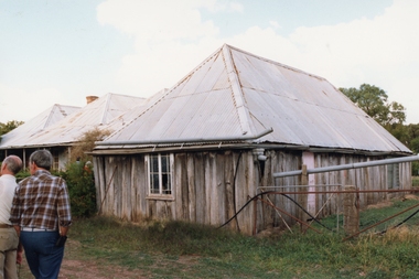 Stawell Historical Society Inc
Photograph, Carr's Plains Homestead taken on a trip by Stawell Historical Society -- Coloured
... Property owned by Ian & Margaret Taylor until 2025. Built of slabs - Steep roof once shingle then covered with iron. ...Slab building with a iron roof, two people in the left of photo....Property owned by Ian & Margaret Taylor until 2025. Built of slabs - Steep roof once shingle then covered with iron. carrs plains Slab building with a iron roof, two people in the left of photo. ...Photos of Carr's Plains taken on a trip by Stawell Historical Society. First home the family lived in on the Carrs Plains property. The Dennis family later Wettenhall Family. Property owned by Ian & Margaret Taylor until 2025. Built of slabs - Steep roof once shingle then covered with iron. Slab building with a iron roof, two people in the left of photo.carrs plains