Showing 69 items matching " social facilities"
-
 Glen Eira Historical Society
Article - Ormond Tennis Club
... ... Social Facilities...Sports Grounds Sports Establishments Ormond Tennis Club Committee Recreations Establishments Sporting Clubs Parks Reserves Social Facilities Local Government Pavilions Organisations Societies Sports Recreations Tennis Leisure Cultural Events Cultural Activities Cultural Structures Cultural Establishments Tennis Courts Go Tennis Access Unlimited Marriott Support Services Disabled People Handicapped People Diviny Kevin Ormond Tennis Club President Voluntary Workers Volunteers Stooke John Schweitz Zvi Victorian Intellectual Disability Tennis Nunes Kelli Gregory Kay Glen Huntly Article Ormond Tennis Club ...This file contains three items. 1/ A 2-page handwritten report by Bob Flavell on the formation and development of the Ormond Tennis Club. 2/ Letter accompanying the report above, sent to Dr. Geulah Solomon by Bob Flavell, regarding his report on the Ormond Tennis Club, dated 06/02/1988. These likely were referred to by Dr Solomon for her book "Caulfield's Heritage". 3/ An article from the GLEN EIRA NEWS on the Ormond Tennis Club’s participation in the Go Tennis program, established to provide people with a disability the opportunity to play tennis, dated 11/2011.ormond tennis club, caulfield council, caulfield, ormond park, clubs, tennis clubs, ormond, glenhuntly, flavell bob, competitions, associations, solomon dr., sports grounds, sports establishments, ormond tennis club committee, recreations establishments, sporting clubs, parks, reserves, social facilities, local government, pavilions, organisations, societies, sports, recreations, tennis, leisure, cultural events, cultural activities, cultural structures, cultural establishments, tennis courts, go tennis, access unlimited, marriott support services, disabled people, handicapped people, diviny kevin, ormond tennis club president, voluntary workers, volunteers, stooke john, schweitz zvi, victorian intellectual disability tennis, nunes kelli, gregory kay, glen huntly -
Glen Eira Historical Society
Article - Murrumbeena Park
... ... Social facilities...Murrumbeena Park Murrumbeena Caulfield Parks Reserves Playgrounds Playground equipment Sports equipment Recreation equipment Children’s playground Gardens Sports grounds Playing fields Plants Kangaroo Road Murrumbeena Trees Sports establishments Recreations establishments Seesaws Slides Swings Monkey bars Murrumbeena Park Committee of Management Murrumbeena Cricket Club Murrumbeena Football Club Clubs Associations Sporting clubs Barbeques Picnics Caulfield Council Social facilities Murrumbeena Park Bowls Club Oakdale Angling Club Landscape Concept Plan Caulfield City Hall Caulfield Town Hall Municipal offices Official buildings Civic centres Local government Council chambers Walking trails THE AGE CAULFIELD CONTACT Article Murrumbeena Park ...This file contains three items. An article from THE AGE by Christopher Bantick, who reminisces on the facilities of Murrumbeena Park in decades past, and reflections on the changes the park has undergone in more recent times, dated 24/05/2008. Four coloured postcards of Murrumbeena Park displaying the flora, paths, play equipment, and facilities, taken by Margie McKenzie Photography, date unknown. An article from the CAULFIELD CONTACT listing the improvements that have and will be made to Murrumbeena Park, including a list of the facilities that are on offer as well as the sporting clubs that make use of the park, dated March 1992.murrumbeena park, murrumbeena, caulfield, parks, reserves, playgrounds, playground equipment, sports equipment, recreation equipment, children’s playground, gardens, sports grounds, playing fields, plants, kangaroo road murrumbeena, trees, sports establishments, recreations establishments, seesaws, slides, swings, monkey bars, murrumbeena park committee of management, murrumbeena cricket club, murrumbeena football club, clubs, associations, sporting clubs, barbeques, picnics, caulfield council, social facilities, murrumbeena park bowls club, oakdale angling club, landscape concept plan, caulfield city hall, caulfield town hall, municipal offices, official buildings, civic centres, local government, council chambers, walking trails, the age, caulfield contact -
 Ballarat Tramway Museum
Document - Photocopy, Neville Gower, "Mayor's Report 1953-1954", Jul. 1997
... Three page covering trams, railways, telephone exchanges (overloaded), buses and other social facilities. Page 3 - set of photos, includes a photo of bogie tram in the city. ...Three page covering trams, railways, telephone exchanges (overloaded), buses and other social facilities. Page 3 - set of photos, includes a photo of bogie tram in the city. ...Photocopy of part of City of Ballarat's Mayor's Report for 1953-1954. Three page covering trams, railways, telephone exchanges (overloaded), buses and other social facilities. Page 3 - set of photos, includes a photo of bogie tram in the city. Of originals held in Ballarat Library. Images added 19-12-2016.trams, tramways, city of ballaarat, trams, railways, civic history -
![1981 Warrnambool and District Community Information Directory front cover [.6]](/media/collectors/4f729f7797f83e030860184f/items/664fef1cdd0f9ab6b51abf51/item-media/66c27aa3202c41c4ca03b234/item-fit-380x285.jpg?cb=6) Warrnambool and District Historical Society Inc.
Warrnambool and District Historical Society Inc.Booklet - Booklet Collection: City of Warrnambool Directory of Services, Collett and Bain
... They contain descriptions of the municipality and lists and details of services, social and community facilities for the period covered....They contain descriptions of the municipality and lists and details of services, social and community facilities for the period covered. ...This is a collection of nine directories published by the City of Warrnambool dating from 1952 to 1992. They contain descriptions of the municipality and lists and details of services, social and community facilities for the period covered.These directories give snapshots of the City of Warrnambool for the years covered and will be useful for research.[.1] 16 pages printed with black and white photographs. The cover is cream card with writing in blue printing and the city of Warrnambool crest in the top left corner. [.2] 16 pages printed with black and white photographs. The cover is yellow card with writing in blue printing and the city of Warrnambool crest in the top left corner. [.3] 8 pages printed with pale yellow feathered design edges on either side of the text. The cover is cream with writing in Blue print and the pale yellow feathered pattern. A coloured City of Warrnambool seal is in the centre top third of the front cover. [.4] A single sheet of buff coloured light weight card folded in half to make a booklet. Black printing with a black Warrnambool crest in the top centre. [.5] 36 page booklet. The cover is of white shiny card with printed purple text. [.6] 96 page booklet. The cover has black printed text and red stylised cartoon like drawings representing different aspects of the community. [.7] 32 page booklet. The cover is of cream card printed with a 5mm wide green line across the front and back. Black ink drawings of Warrnambool landmarks by P Bryant feature on the cover and the Warrnambool City seal is in the bottom right hand corner. [.8] 20 page booklet of white paper with black text printing. There is a photo of the Tourist information centre on the rear cover. The Warrnambool city crest on the front cover which has a black geometrical edging design. [.9] 24 page booklet of white paper with black text printing. The front cover has the Warrnambool city crest in the top left hand corner and a photograph of the Lake Pertobe playground in the bottom two thirds. The back cover has a photo of the Warrnambool Saleyards. [.1] City of Warrnambool Victoria, Australia [.2] City of Warrnambool Victoria, Australia [.3] City of Warrnambool [.4] City of Warrnambool Organisations taking part in the Community Life of the City of Warrnambool 1952 [.5] Warrnambool Directory of Social Services [.6] Community Information Directory Warrnambool and District 1981 [.7] Community Information Guide 1991/1992 City of Warrnambool [.8] Citizens' Information Handbook for 1976-1977 [.9] Citizens' Information Handbook for 1977-1978 warrnambool, warrnambool city directory, warrnambool community organisations -
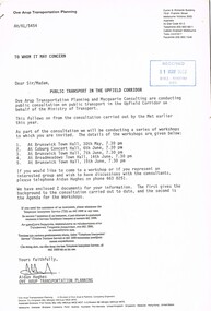
 Whitehorse Historical Society Inc.
Article, New Sports Facilities in Vermont South, March 2024
... The Vermont South Club offers tennis, lawn bowls and darts along with new facilities for social activities....The Vermont South Club offers tennis, lawn bowls and darts along with new facilities for social activities. Morack Golf Course Vermont South Club Morack Public Golf will be officially opened in March 2024. ...Morack Public Golf will be officially opened in March 2024. The new multipurpose paviliopn at Vermont Souh Club will bne officially opened mid-April.non-fictionMorack Public Golf will be officially opened in March 2024. The new multipurpose paviliopn at Vermont Souh Club will bne officially opened mid-April.morack golf course, vermont south club -
 Melbourne Tram Museum
Document - Report, Ove Arup Transportation Planning, "Public Transport in the Upfield Corridor", May. 1989
... Provides an outline of the consultation process, dates, gives an outline of the options for the corridor, social costs, access to facilities, shoppers and business, costs and benefits. ...Provides an outline of the consultation process, dates, gives an outline of the options for the corridor, social costs, access to facilities, shoppers and business, costs and benefits. ...Consultative report - 8 A4 pages, stapled in the top right hand corner, titled "Public Transport in the Upfield Corridor". Prepared by Ove Arup Transportation Planning, dated May 1989. Provides an outline of the consultation process, dates, gives an outline of the options for the corridor, social costs, access to facilities, shoppers and business, costs and benefits. Two copies held. Second copy stamped 31/5/1989 -WMR Registry HDV.trams, tramways, upfield light rail, sydney rd, north coburg, conversion -
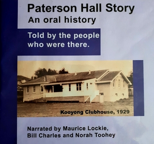 Vision Australia
Audio - Sound recording, Paterson Hall Story: an oral history told by the people who were there, 2002
... The hall was originally built as a clubhouse for blind cricketers in 1927, but by 1929 it had been extended to include a social hall and other facilities including a verandah where spectators could watch the cricket. ...The hall was originally built as a clubhouse for blind cricketers in 1927, but by 1929 it had been extended to include a social hall and other facilities including a verandah where spectators could watch the cricket. ...Paterson Hall Story is told through the reminiscences of 23 people who played an active part in the life of a popular recreational and entertainment hub from 1929 to 1999. They relate how a simple concrete structure in Glenferrie Road, Kooyong became a 'home away from home' for people who were blind or vision impaired, their families and friends. The hall was originally built as a clubhouse for blind cricketers in 1927, but by 1929 it had been extended to include a social hall and other facilities including a verandah where spectators could watch the cricket. Over the years the hall was used for activities as diverse as square dancing, singing, craft classes, ball games, art and craft shows, drama groups and annual meetings.60 MP3 sound files of oral history interviews and book excerptsNarrated by Maurice Lockie, Bill Charles and Norah Tooheypaterson hall, association for the advancement of the blind, victorian blind cricket association -
 The Beechworth Burke Museum
Photograph - Lantern Slide, c1900
... Three medical or social welfare facilities opened in the mid-1800s as part of a push by the township to become a regional centre for Government services. ...Three medical or social welfare facilities opened in the mid-1800s as part of a push by the township to become a regional centre for Government services. ...This image appears to show nurses at what is now the Mayday Hills Mental Asylum arriving for work in approximately 1900. These individuals are part of a long history of nursing in Beechworth. Three medical or social welfare facilities opened in the mid-1800s as part of a push by the township to become a regional centre for Government services. These were the Ovens District Hospital (opened in 1857), the Ovens Benevolent Asylum (opened in 1863), and the Beechworth Mental Hospital (opened in 1867 and renamed Mayday Hills Hospital at Centenary celebrations in 1967). It was recognised that the unsettled living conditions, poverty and relative isolation of the Goldfields environment could produce 'mental disturbances' which required local treatment facilities as services in Melbourne were too far away. Carole Woods' publication 'A Titan's Field' describes activities undertaken by patients at Beechworth Mental Hospital as including monthly balls and occasional concerts as well as work to make the facility self-supporting such as farm work and making clothes. She mentions a report in 1870 that the approximately 300 patients were clean and neat with 'no-one in restraint or seclusion' but that by 1905 the organisation had 623 patients which placed strain on building infrastructure such as heating and water supplies, leading to high turnover of nurses and other issues. A program of building works to extend and improve facilities followed over subsequent decades. Lantern slides, sometimes called 'magic lantern' slides, are glass plates on which an image has been secured for the purpose of projection. Glass slides were etched or hand-painted for this purpose from the Eighteenth Century but the process became more popular and accessible to the public with the development of photographic-emulsion slides used with a 'Magic Lantern' device in the mid-Nineteenth Century. Photographic lantern slides comprise a double-negative emulsion layer (forming a positive image) between thin glass plates that are bound together. A number of processes existed to form and bind the emulsion layer to the base plate, including the albumen, wet plate collodion, gelatine dry plate and Woodburytype techniques. Lantern slides and magic lantern technologies are seen as foundational precursors to the development of modern photography and film-making techniques This glass slide is significant because it provides insight into Beechworth's social and medical amenities in the early Twentieth Century, around the time of Australia's Federation into one nation. It is also an example of an early photographic and film-making technology in use in regional Victoria in the time period.Thin translucent sheet of glass with a rectangular image printed on the front and framed in a black backing. It is held together by metals strips to secure the edges of the slide.Obverse: i /burke museum, beechworth, lantern slide, slide, glass slide, plate, burke museum collection, photograph, monochrome, magic lantern, indigo shire, north-east victoria, nineteenth century, 1900s, twentieth century, emulsion slides, nursing, nurses, mental hospitals, lunatic asylums, asylums, social services, social welfare, insane asylums, mental health, infrastructure -
 The Beechworth Burke Museum
Photograph - Lantern Slide, c1900
... Three medical or social welfare facilities opened in the mid-1800s as part of a push by the township to become a regional centre for Government services. ...Three medical or social welfare facilities opened in the mid-1800s as part of a push by the township to become a regional centre for Government services. ...This image appears to show nurses at what is now the Mayday Hills Mental Asylum in approximately 1900. These individuals are part of a long history of nursing in Beechworth. Three medical or social welfare facilities opened in the mid-1800s as part of a push by the township to become a regional centre for Government services. These were the Ovens District Hospital (opened in 1857), the Ovens Benevolent Asylum (opened in 1863), and the Beechworth Mental Hospital (opened in 1867 and renamed Mayday Hills Hospital at Centenary celebrations in 1967). It was recognised that the unsettled living conditions, poverty and relative isolation of the Goldfields environment could produce 'mental disturbances' which required local treatment facilities as services in Melbourne were too far away. Carole Woods' publication 'A Titan's Field' describes activities undertaken by patients at Beechworth Mental Hospital as including monthly balls and occasional concerts as well as work to make the facility self-supporting such as farm work and making clothes. She mentions a report in 1870 that the approximately 300 patients were clean and neat with 'no-one in restraint or seclusion' but that by 1905 the organisation had 623 patients which placed strain on building infrastructure such as heating and water supplies, leading to high turnover of nurses and other issues. A program of building works to extend and improve facilities followed over subsequent decades. Lantern slides, sometimes called 'magic lantern' slides, are glass plates on which an image has been secured for the purpose of projection. Glass slides were etched or hand-painted for this purpose from the Eighteenth Century but the process became more popular and accessible to the public with the development of photographic-emulsion slides used with a 'Magic Lantern' device in the mid-Nineteenth Century. Photographic lantern slides comprise a double-negative emulsion layer (forming a positive image) between thin glass plates that are bound together. A number of processes existed to form and bind the emulsion layer to the base plate, including the albumen, wet plate collodion, gelatine dry plate and Woodburytype techniques. Lantern slides and magic lantern technologies are seen as foundational precursors to the development of modern photography and film-making techniques.This glass slide is significant because it provides insight into Beechworth's social and medical amenities in the early Twentieth Century, around the time of Australia's Federation into one nation. It is also an example of an early photographic and film-making technology in use in regional Victoria in the time period.Thin translucent sheet of glass with a circular image printed on the front and framed in a black backing. It is held together by metals strips to secure the edges of the slide.burke museum, beechworth, lantern slide, slide, glass slide, plate, burke museum collection, photograph, monochrome, magic lantern, indigo shire, north-east victoria, nineteenth century, 1900s, twentieth century, emulsion slides, nursing, nurses, mental hospitals, lunatic asylums, asylums, social services, social welfare, insane asylums, mental health, infrastructure -
Northern District School of Nursing. Managed by Bendigo Historical Society Inc.
Administrative record - Northern District School of Nursing Graduates Association - Part of a Questionaire on the future of the Association, 1980s
... The Association maintains connections among graduates, with opportunities for tours and social contact. Some school facilities have been repurposed (e.g., library, recreation room, hostel). ...The Association maintains connections among graduates, with opportunities for tours and social contact. Some school facilities have been repurposed (e.g., library, recreation room, hostel). ...The Northern District School of Nursing in Victoria, Australia Graduates Association: History of the School Managed by a committee including hospital administrators, medical professionals, and nursing leaders from several regional hospitals. Associated with major hospitals in the Northern District, including Bendigo Base, Mildura Base, Castlemaine, Echuca, Swan Hill, St. Arnaud, and Kyneton District Hospitals. Provide high-quality theoretical and practical nursing training. Raise the standard of nursing education in the region. Maintain the highest principles of nursing practice. Applicants must be at least 17 years old and hold a Proficiency Certificate or higher educational qualification. Application involves submitting forms, certificates, an interview, an aptitude test, and a medical examination. A three-month probationary period follows initial acceptance. Preliminary Training School: Four-week introductory course covering basic nursing, anatomy, hygiene, and practical skills. Practical experience in various hospital departments, guided by senior staff. Study Block Plan: Includes several blocks of theoretical and practical instruction throughout the three-year program. Regular school exams and two state exams (First Professional and Final State) are required for progression and graduation. Nurses work a 40-hour week with at least one or two days off per week and three weeks of annual leave. Accommodation is provided in comfortable hostels with good facilities. Uniforms are supplied free; nurses provide their own shoes and stockings. Salaries and allowances are regulated, with deductions for board and free medical care. Additional Information Post-Graduate Opportunities. Senior positions require further experience and additional certificates (e.g., Midwifery, Infant Welfare).Diploma courses available in administration, teaching, and specialized nursing fields. Bursaries are available for advanced study.Career Prospects: Graduates can pursue roles in administration, teaching, ward and departmental leadership, district and visiting nursing, industrial and school nursing, and more. Opportunities existed both within hospitals and in community or specialized settings.FAQs and Practical Details. Minimal training costs (mainly exam fees and personal items).Living out allowances and travel expenses are covered. Four training intakes per year; waiting periods are short if qualifications are met.Northern District School of Nursing Graduates Association - Part of a Questionaire on the future of the Association This item contains the following documents: 3793.11a Part of a Questionaire on the future of the Association This document reviews the history, current status, and proposed changes for the Northern District Nursing Graduates Association (NDSNGA): The NDSN was a major development in nursing education, though initially met with resistance and seen by some as radical. Advocacy by figures like Miss Long was crucial in advancing nursing education standards. There is concern that without updates, the Association may become irrelevant or cease to exist as new generations of graduates emerge. Minor changes could help the Association better serve practicing, non-practicing, and retired nurses, fostering community and professional discussion. Membership Eligibility:Open to graduates of NDSN and CAE nursing courses in the region.Include students who did not complete the course. Allow nurses who graduated elsewhere but worked in the region for at least five years. Name Change Options include minor modifications (e.g., Northern District Nursing Graduates Association) or broader regional names (e.g., Loddon Campaspe Region). The Association maintains connections among graduates, with opportunities for tours and social contact. Some school facilities have been repurposed (e.g., library, recreation room, hostel). Progress on creating an archival repository and potential museum is slow due to limited resources and the scale of groundwork required. Members are encouraged to contribute historical materials. Written communication is less frequent among nurses, but efforts are being made to gather feedback via newsletters and questionnaires. Member input is sought on proposed changes, especially regarding membership and the Association's name. These points highlight the Association's ongoing efforts to adapt, preserve its heritage, and remain relevant to both current and future nursing professionals.nurse training, lister house -
Northern District School of Nursing. Managed by Bendigo Historical Society Inc.
Administrative record - Northern District School of Nursing Graduates Association - Letter from the Health Department Victoria, 07 July 1987
... The Association maintains connections among graduates, with opportunities for tours and social contact. Some school facilities have been repurposed (e.g., library, recreation room, hostel). ...The Association maintains connections among graduates, with opportunities for tours and social contact. Some school facilities have been repurposed (e.g., library, recreation room, hostel). ...The Northern District School of Nursing in Victoria, Australia Graduates Association: History of the School Managed by a committee including hospital administrators, medical professionals, and nursing leaders from several regional hospitals. Associated with major hospitals in the Northern District, including Bendigo Base, Mildura Base, Castlemaine, Echuca, Swan Hill, St. Arnaud, and Kyneton District Hospitals. Provide high-quality theoretical and practical nursing training. Raise the standard of nursing education in the region. Maintain the highest principles of nursing practice. Applicants must be at least 17 years old and hold a Proficiency Certificate or higher educational qualification. Application involves submitting forms, certificates, an interview, an aptitude test, and a medical examination. A three-month probationary period follows initial acceptance. Preliminary Training School: Four-week introductory course covering basic nursing, anatomy, hygiene, and practical skills. Practical experience in various hospital departments, guided by senior staff. Study Block Plan: Includes several blocks of theoretical and practical instruction throughout the three-year program. Regular school exams and two state exams (First Professional and Final State) are required for progression and graduation. Nurses work a 40-hour week with at least one or two days off per week and three weeks of annual leave. Accommodation is provided in comfortable hostels with good facilities. Uniforms are supplied free; nurses provide their own shoes and stockings. Salaries and allowances are regulated, with deductions for board and free medical care. Additional Information Post-Graduate Opportunities. Senior positions require further experience and additional certificates (e.g., Midwifery, Infant Welfare).Diploma courses available in administration, teaching, and specialized nursing fields. Bursaries are available for advanced study.Career Prospects: Graduates can pursue roles in administration, teaching, ward and departmental leadership, district and visiting nursing, industrial and school nursing, and more. Opportunities existed both within hospitals and in community or specialized settings.FAQs and Practical Details. Minimal training costs (mainly exam fees and personal items).Living out allowances and travel expenses are covered. Four training intakes per year; waiting periods are short if qualifications are met.Northern District School of Nursing Graduates Association - Letter from the Health Department Victoria 07 July 1987 to Mrs M Worme, Secretary This item contains the following documents: 3793.12a Letter from the Health Department Victoria 07 July 1987 to Mrs M Worme, Secretary. This document is a formal acceptance letter from a Senior Operations Officer at the S Health Department Victoria. The officer accepts an invitation to attend the Northern District School of Nursing Past Graduates group meeting at Lister House on Monday, 27 July 1987, at 10:30 a.m. This document reviews the history, current status, and proposed changes for the Northern District Nursing Graduates Association (NDSNGA): The NDSN was a major development in nursing education, though initially met with resistance and seen by some as radical. Advocacy by figures like Miss Long was crucial in advancing nursing education standards. There is concern that without updates, the Association may become irrelevant or cease to exist as new generations of graduates emerge. Minor changes could help the Association better serve practicing, non-practicing, and retired nurses, fostering community and professional discussion. Membership Eligibility:Open to graduates of NDSN and CAE nursing courses in the region.Include students who did not complete the course. Allow nurses who graduated elsewhere but worked in the region for at least five years. Name Change Options include minor modifications (e.g., Northern District Nursing Graduates Association) or broader regional names (e.g., Loddon Campaspe Region). The Association maintains connections among graduates, with opportunities for tours and social contact. Some school facilities have been repurposed (e.g., library, recreation room, hostel). Progress on creating an archival repository and potential museum is slow due to limited resources and the scale of groundwork required. Members are encouraged to contribute historical materials. Written communication is less frequent among nurses, but efforts are being made to gather feedback via newsletters and questionnaires. Member input is sought on proposed changes, especially regarding membership and the Association's name. These points highlight the Association's ongoing efforts to adapt, preserve its heritage, and remain relevant to both current and future nursing professionals.nurse training, lister house, m worme -
 Kiewa Valley Historical Society
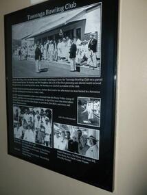
Posters - "Tawonga Remembers" x 7, 2016
... Tawonga consisted of essential amenities including a store, school, Butter factory, sporting facilities, post office, hall and hotel. Activities involved sport, social get togethers eg. dances, fund raising, CWA etc....Tawonga consisted of essential amenities including a store, school, Butter factory, sporting facilities, post office, hall and hotel. Activities involved sport, social get togethers eg. dances, fund raising, CWA etc. ...The town of Tawonga is in the Kiewa Valley surrounded by farmland. It is adjacent to Mt Beauty (built from 1946), an SECV town built for the workers on the Kiewa Hydro Electric Scheme which was being constructed from 1911 to 1961. Tawonga consisted of essential amenities including a store, school, Butter factory, sporting facilities, post office, hall and hotel. Activities involved sport, social get togethers eg. dances, fund raising, CWA etc.The posters are a collection of historical photos, documentation and information regarding the history of the town of Tawonga, which is the centre of a farming community in the Kiewa Valley. Posters framed with thin black plastic strip, covered by glass. Each one has a title re 'Tawonga Remembers' and includes print and photos. 1. Tawonga Bowling Club 1953 includes 5 B&W photos on black background. 2. Bogong Hotel 4 B&W photos on black background. 3. Bogong Hotel 1970s - 2011 3 B&W photos and 3 coloured photos on black background 4. Tawonga Butter Factory 3 B&W photos on sepia background. 5. Tawonga Store 2 B&W photos on black background. 6. Post Office 3 B&W photos and 1 coloured photo on sepia background. 7. Debutante Balls held in the Hall 2 B&W photos on sepia background.tawonga, photos of early tawonga, kiewa valley, tawonga remembers -
 Kiewa Valley Historical Society
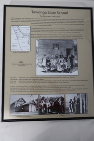
Posters - "Tawonga Remembers" x 5, 2016
... Tawonga consists of essential amenities including a store, school, post office, butter factory, sporting facilities, hall and hotel. Activities involved sport, social get togethers eg. dances, fund raising, CWA etc....Tawonga consists of essential amenities including a store, school, post office, butter factory, sporting facilities, hall and hotel. Activities involved sport, social get togethers eg. dances, fund raising, CWA etc. ...The town of Tawonga is in the Kiewa Valley surrounded by farmland. It is adjacent to Mt Beauty (built from 1946), an SECV town built for workers on the SECV's Kiewa Hydro Electric Scheme, which was being constructed from 1911-1961. Tawonga consists of essential amenities including a store, school, post office, butter factory, sporting facilities, hall and hotel. Activities involved sport, social get togethers eg. dances, fund raising, CWA etc.The posters are a collection of historical photos, documentation and information re the history of the town of Tawonga, which is the centre of a farming community in the Kiewa Valley.Posters framed with thin black plastic strip, covered by glass. Each one has a title re "Tawonga Remembers" and includes print and photos in black and white. These have a beige background. 1. Tawonga 1907; 2. Tawonga 1962; 3. Tawonga State School- 1880-1929; 4. Tawonga Primary School -1960; 5. The Beginning of Change: 1930-1970tawonga, photos of early tawonga, kiewa valley, tawonga remembers, tawonga school -
 Kiewa Valley Historical Society
Posters - "Tawonga Remembers" x 5
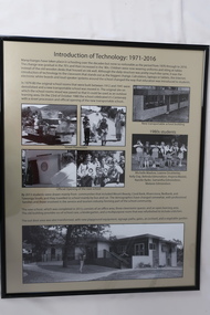
... Tawonga consisted of essential amenities including a store, school, butter factory, sporting facilities, post office, hall and hotel. Activities involved sport, social get togethers eg. dances, fundraising, CWA etc....Tawonga consisted of essential amenities including a store, school, butter factory, sporting facilities, post office, hall and hotel. Activities involved sport, social get togethers eg. dances, fundraising, CWA etc. ...The town of Tawonga is in the Kiewa Valley surrounded by farmland. It is adjacent to Mt Beauty (built from 1946), an SECV town built for the workers on the Kiewa Hydro Electric Scheme which was being constructed from 1911-to 1961. Tawonga consisted of essential amenities including a store, school, butter factory, sporting facilities, post office, hall and hotel. Activities involved sport, social get togethers eg. dances, fundraising, CWA etc.The posters are a collection of historical photos, documentation and information regarding the history of the town of Tawonga, which is the centre of a farming community in the Kiewa Valley.Posters framed with thin black plastic strip, covered by glass. Each one has a title re "Tawonga Remembers" and includes print and photos in black and white. Beige background. 1.Butcher Shop and Slaughter Yard; 2. Tawonga Saw Mill; 3. Post Office; 4. Tawonga District Hospital (2 pages); 5. Introduction of Technology: 1971-2016tawonga, photos of early tawonga, kiewa valley, tawonga remembers, businesses -
 Kiewa Valley Historical Society
Posters - "Tawonga Remembers" x 5
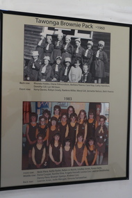
... Tawonga consisted of essential amenities including a store, school, butter factory, sporting facilities, post office, hall and hotel. Activities involved sport, social get togethers eg. dances, fundraising, CWA etc....Tawonga consisted of essential amenities including a store, school, butter factory, sporting facilities, post office, hall and hotel. Activities involved sport, social get togethers eg. dances, fundraising, CWA etc. ...The town of Tawonga is in the Kiewa Valley surrounded by farmland. It is adjacent to Mt Beauty (built in 1946) , an SECV town built for the workers on the Kiewa Hydro Electric Scheme which was being constructed from 1911-1961. Tawonga consisted of essential amenities including a store, school, butter factory, sporting facilities, post office, hall and hotel. Activities involved sport, social get togethers eg. dances, fundraising, CWA etc.The posters are a collection of historical photos, documentation and information regarding the history of the town of Tawonga, which is the centre of a faming community in the Kiewa Valley.Posters framed with thin black plastic strip, covered, by glass. Each one has a title re "Tawonga Remembeers" and includes print and photos in black and white. Beige background. 1. The History of Guiding in Tawonga; 2. Tawonga Cubs; 3. Cubs and Scouts; 4. Tawonga Brownie Pack -1960; 5. Tawonga Guide Company -1966tawonga, photos of early tawonga, kiew valley, tawonga remembers, cubs, scouts, brownies, guides -
 Kiewa Valley Historical Society
Posters - "Tawonga Remembers" x 5
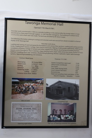
... Tawonga consisted of essential amenities including a store, school, butter factory, sporting facilities, post office, hall and hotel. Activities involved sport, social get togethers eg. dances, fundraising, CWA etc. ...Tawonga consisted of essential amenities including a store, school, butter factory, sporting facilities, post office, hall and hotel. Activities involved sport, social get togethers eg. dances, fundraising, CWA etc. ...The town of Tawonga is in the Kiewa Valley surrounded by farmland. It is adjacent to Mt Beauty (built from 1946), an SECV town built for the workers on the Kiewa Hydro Electric Scheme which was being constructed from 1911-1961. Tawonga consisted of essential amenities including a store, school, butter factory, sporting facilities, post office, hall and hotel. Activities involved sport, social get togethers eg. dances, fundraising, CWA etc. The posters are a collection of historical photos, documentation and information regarding the history of the town of Tawonga, which is the centre of a farming community in the Kiewa Valley.Posters framed with thin black plastic strip, covered, by glass. Each one has a title re "Tawonga Remembers" and includes print and photos in black and white. Beige background. 1. Tawonga Memorial Hall 2. Opening of the Second Public Hall 1925 3. Public Hall for Tawonga 4. Tawonga Debutante Ball 1947 5. Tawonga Hall Ghosttawonga, photos of early tawonga, kiewa valley, tawonga remembers, tawonga hall -
 Kiewa Valley Historical Society
Posters - "Tawonga Remembers" x 4
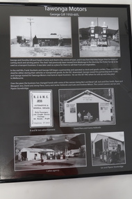
... Tawonga consisted of essential amenities including a store, school, butter factory, sporting facilities, post office, hall and hotel. Activities involved sport, social get togethers eg. dances, fundraising, CWA etc....Tawonga consisted of essential amenities including a store, school, butter factory, sporting facilities, post office, hall and hotel. Activities involved sport, social get togethers eg. dances, fundraising, CWA etc. ...The town of Tawonga is in the Kiewa Valley surrounded by farmland. It is adjacent to Mt Beauty (built in 1946), an SECV town built for the workers on the Kiewa Hydro Electric Scheme which was being constructed from 1911 to 1961. Tawonga consisted of essential amenities including a store, school, butter factory, sporting facilities, post office, hall and hotel. Activities involved sport, social get togethers eg. dances, fundraising, CWA etc.The posters are a collection of historical photos, documentation and information regarding the history of the town of Tawonga,which is the centre of a farming community in the Kiewa Valley.Poster framed with thin black plastic strip, covered, by glass. Each one has a title re "Tawonga Remembers" and includes print and phtots in black and white. Black background. 1. Tawonga SEC Depot; 2. Tawonga Service Station circa 1940s; 3. George Johnston's Taxi Service; 4. Tawonga Motors 1950-60stawonga, photos of early tawonga, kiewa valley, tawonga remembers, transport -
 Kiewa Valley Historical Society
Posters - "Tawonga Remembers" x 4
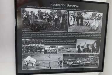
... Tawonga consisted of essential amenities including a store, school, butter factory, sporting facilities, post office, hall and hotel. Activities involved sport, social get togethers eg. dances, fundraising , CWA etc....Tawonga consisted of essential amenities including a store, school, butter factory, sporting facilities, post office, hall and hotel. Activities involved sport, social get togethers eg. dances, fundraising , CWA etc. ...The town of Tawonga is in the Kiewa Valley surrounded by farmland. It is adjacent to Mt Beauty (built from 1946), an SECV town built for the workers on the Kiewa Hydro Electric Scheme which was being constructed from 1911 to 1961. Tawonga consisted of essential amenities including a store, school, butter factory, sporting facilities, post office, hall and hotel. Activities involved sport, social get togethers eg. dances, fundraising , CWA etc.The posters are a collection of historical photos, documentations and information regarding the history of the town of Tawonga, which is the centre of a farming community in the Kiewa Valley.Posters framed with thin black plastic strip, covered, by glass. Each one has a title re "Tawonga Remembers" and includes print and photos in black and white. Black background. 1. Recreation Reserve 2. St Aidan's Church 3. Lois Pearce 4. Boarding Housetawonga, photos of early tawonga, kiewa valley, tawonga remembers, tawonga businesses -
 Kiewa Valley Historical Society
Posters - "Tawonga Remembers" x 8
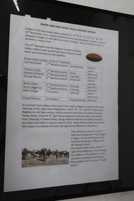
... Tawonga consisted of essential amenities including a store, school, butter factory, sporting facilities, post office, hall and hotel. Activities involved sport, social get togethers eg. dances, fundraising, CWA etc. ...Tawonga consisted of essential amenities including a store, school, butter factory, sporting facilities, post office, hall and hotel. Activities involved sport, social get togethers eg. dances, fundraising, CWA etc. ...The town of Tawonga is in the Kiewa Valley surrounded by farmland. it is adjacent to Mt Beauty (built from 1946), an SECV town built for the workers on the Kiewa Hydro Electric Scheme which was being constructed from 1911 to 1961. Tawonga consisted of essential amenities including a store, school, butter factory, sporting facilities, post office, hall and hotel. Activities involved sport, social get togethers eg. dances, fundraising, CWA etc. The posters are a collection of historical photos, documentations and information regarding the history of the town of Tawonga, which is the centre of a farming community in the Kiewa Valley.Posters framed with thin black plastic strip, covered by glass. Each one has a title re "Tawonga Remembers" and includes print and photos in black and white. White background. 1. Where and How Kiewa Valley Soldiers Served; 2. Tawonga and Dederang Servicemen; 3. Kergunyah and Gundowring Servicemen and Women; 4. Kiewa and Tangambalanga Servicemen.5. Sacrifice and Honour; 6. The End of the Great War; 7. World War 1914-18; 8. Soldiers in Uniform (Black background and glass cracked) tawonga, photos of early tawonga, kiewa valley, tawonga remembers, ww1 -
 Kiewa Valley Historical Society
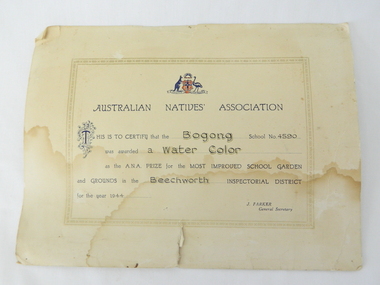
Certificate Prize - Bogong School, Australian Natives Association, 1944
... Kiewa Valley Historical Society Mount Beauty Information Centre 31 Bogong High Plains Rd Mt Beauty high-country Historical document detailing the significance of beautification and pride taken by all who worked and studied at Bogong School 4590 This item represents a period in school and social development when the community covered the beautification of school facilities without State involvement. ...Historical document detailing the significance of beautification and pride taken by all who worked and studied at Bogong School 4590This item represents a period in school and social development when the community covered the beautification of school facilities without State involvement. A period in time when public resources could only cover city and larger townships Buff coloured cardboard certificateThis is to certify that the Bogong School 4590 was awarded a water colour as the A.N.A. prize for the most improved school gardening and grounds in the Beechworth Inspectorial District for 1944 signed J. Parker General Secretarybogong school 4590, gardening awards, beechworth inspectorial -
 Kiewa Valley Historical Society
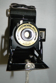
Camera Box Brownie Folding, Six 20 Folding Brownie KodetteII, Circa 1948 to late 1970s
... The social implications of this trend will continue to provide a broader requirement for medical and other facilities geared up to the requirements of an aging population. ...This camera was made for the mobile photographer and the camera manufacturer Kodak was at the peak of production. Mr. George Eastman, the company's founder, who invented roll film, which could withstand the outdoor activities and therefor replaced photographic plates. In 1900, the Box Brownie camera was first released Kodak's motto was' "You push the button, we do the rest," The film used in this camera was Kodak Verichrome 620 introduced in 1936 and only went out of production 2009. This camera was a vintage 1970s one. Between 1963 and 1970 the company sold 50 million of this type of camera. The production of smaller and more user friendly digital cameras, mainly from Japan finally nailed the coffin lid on the Kodak Company. Ironically, one of Kodak's engineers called Steve Sasson, devised a camera that could save images using electronic circuits. The images were transferred onto a tape cassette and were viewable by attaching the camera to a TV screen, however Kodak tried to maintain its photographic film products beyond its "use by date". In1975 Kodak becomes the first company to make a digital camera, however the Japanese manufacturers could make smaller and more compact cameras ending Kodak's monopoly and eventual demise.This particular "box brownie" was used by Margaret Shefford, nee Turner, who with her husband retired, in the 1980s, to Mount Beauty. The camera was purchased in the 197's and used on their cruise to England. The significance of this item is that at the time of its introduction to Mount Beauty the camera was a "state of the art", for general public, camera introduced by an ever increasing influx of retirees. This identifies the Kiewa Valley not only as an attraction for sightseers and overseas tourists but also retirees. The social implications of this trend will continue to provide a broader requirement for medical and other facilities geared up to the requirements of an aging population. As a lot of cities in Australia have increasing levels of violence (mainly drug related) rural "retreats" are becoming more sought after by sections of "the gentle populous"This is a black metal rectangular camera, rounded on the ends and has silver colored fittings(stainless steel) and a small leather handle on hinges the left side (facing the lens). The folding lens and shutter component fold out from the main compartment. Two metal arms swing out and hold the lens and collapsible lens body to the required length. When not in use this collapsible (folding) lens extension is fastened to the main body structure providing security and preventing damage to the folding material. The camera has a collapsible eye piece or view finder at the top end. The right hand bottom end has a cylindrical film wider (polished steel). Inside there are two cylindrical cavities, one holding the roll of unexposed film and the other (winder) end a cylinder onto which the unexposed film is wound through for each picture frame. There is a locking mechanism to hold the folding lens structure to the main box structure. See KVHS 0419B for its carrying caseNo external makings but when the lens is folded out it exposes manufacturing information on metal base around the lens " Kodette II B I shutter"(B= Bulb and I= Instant), underneath this, in larger print, is "'FOLDING 'BROWNIE' SIX - 20" below the lens and in smaller print, "made in Great Britain" and underneath this "by KODAK ltd"kodak kodette ii, folding brownie camera, photography, hobby personal item, tourist gadgets. -
Kiewa Valley Historical Society
Camera Case for Box Brownie, Circa mid to late 1900s
... This social and demographic shift by retirees will produce a greater need for changes in facilities required by an increasing aged population. ...When this leather case was made it was the only material available that not only looked fashionable but also was able to absorb any small knocks or scratches which may happen to the mobile but still delicate camera. Digitalisation of photographic equipment for non professional use brought with it a reduction in camera size (pocket), increased portability and the dispensing of thick leather cases. With the increase of camera functions on mobile telephones, the need by tourists and the general public for a dedicated camera is rapidly diminishing. The protective leather wrapping for expensive, professional goods, especially electronics is very rare and foam padded aluminium bags and containers are the preferred mode for travel.This particular leather case has travelled to and from England via an ocean cruise by a now retired couple living in the Kiewa Valley. It is significant to this region because it underlines the slow transition from a purely farming, grazing, mining and tourist region to an area opening up to a specific socio-economical structure for retirees. This social and demographic shift by retirees will produce a greater need for changes in facilities required by an increasing aged population. Though it may take more time for cities and larger towns to come to grips with a growing aged population, rural areas(because these will define more clearly any imbalance of population) present the first demonstrative change to Australia, and world wide, a population based phenomenon.This item is a brown coloured leather camera case (Box Brownie Six-20) with an adjustable strap and associated buckle. The leather has been moulded to the shape of the camera and is slightly tapered as a closing flap fastened at the front with a lockable clasp. The end of the leather flap has a metal(tin) with a semi circular ring formed to allow it to be held as part of the clasp. Pressed into the underbelly of the semicircular closing mechanism is"PAT. APPLIED FOR" and underneath this"MADE IN ENGLAND" camera, case photography, hobby, personal equipment -
 Kiewa Valley Historical Society
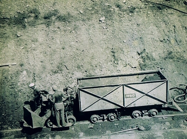
Photograph Shovel Truck, Shovel Loading Rail Truck, circa 1950s
... social and economic development of the Victorian Alps region. The fast expansion of smaller settlements brought about increased pressures on the welfare viability of certain subgroups within the region e.g. farming, droving and commerce (caravan hawkers versus static shops). These changes brought about a heightened awareness by both local and State Governments to upgrade not only facilities ...This item shows the excavation of the side of a railway track using a pneumatic shovel and a rail mounted truck by two workmen. The period covered was well before State Health and Safety requirements, such as helmets, became law. It also details that the workmen were from European heritage as their head coverings were a handkerchief knotted at each corner. This was typical for workmen of this heritage, others used caps or hats or no head covering at all (the macho male look)The photograph of this item was one of many depicting great achievements and opening up the region. A visual link or time capsule of the 1950s rural/mining sectors clashing with the established rural industriesThis photo depicts the time (1950's) and place (Bogong and Mount Beauty) where construction workers had an immense impact, not only on the physical environment but also on the social and economic development of the Victorian Alps region. The fast expansion of smaller settlements brought about increased pressures on the welfare viability of certain subgroups within the region e.g. farming, droving and commerce (caravan hawkers versus static shops). These changes brought about a heightened awareness by both local and State Governments to upgrade not only facilities within the region but also access to the region. Black and white photo of two workmen on a rail mounted shovel truck. The photo is of good definition allowing a clear view of the subject matter. The paper is semi gloss.On the back of the photo, paper suppliers etchings are "Kodak XtraLife II paper"mining, hydro electricity, victorian alps, construction camps, earth moving machines -
 Kiewa Valley Historical Society
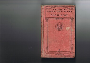
Book - Reference Chemistry, Elements of Chemistry, first printed 1887 this item 1921
... social stimulant to learn exists. The "local school" mind set within rural areas was, even before the improvement of the communication "explosion" of the early 1900s followed by the internet facilities of the late 1900s, the greatest drive in cutting the anomalies between city and rural learning facilities. ...This item is a good example of a pre 1960's school science reference books. It contains sketches of experimental apparatus and not colored photographs of later text books. Although the sketches are very instructional they do not show the various colours obtained when mixing some compounds. The history of reprints demonstrates the quality of the information and the ease of study for students using this book. The era of this publication was a time when sources for knowledge in schools was restricted to mainly school books and teacher demonstrations. The student in the 2 Millennium has a far greater reference source available e.g. the internet. This book is significant to the Kiewa Valley as the Davies family (Tas Davies, penned on the first page), belong to the early settlers of the valley. The book acknowledges that although the region was relatively isolated up to the mid 1900s, the good teaching methods of local schools did not suffer in this rural area. This region was not in the backwaters of scholarly development and modern progressive thought. As with "school of the air" distances in rural areas, between centres of learning and recipients, became irrelevant provided that the social stimulant to learn exists. The "local school" mind set within rural areas was, even before the improvement of the communication "explosion" of the early 1900s followed by the internet facilities of the late 1900s, the greatest drive in cutting the anomalies between city and rural learning facilities. Government decentralising higher education facilities into regional centres (Wodonga - Albury) provided greater access for the learned mind.This item (book) has a faded red colour, hard cover with black print and rectangular design. Within this design is an encircled double "M" and "&" (in the left inverted V of the M) and a "Co" (in the right inverted V of the M). On the front cover "MACMILLAN'S SCHOOL CLASS BOOKS CHEMISTRY" and on the spine "ELEMENTS OF CHEMISTRY" underneath "REMSEN" and at the bottom"MACMILLAN & Co"school, chemistry, text books, science experiments -
 Kiewa Valley Historical Society
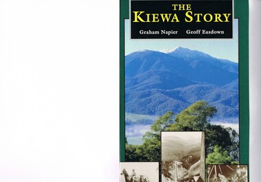
Book - Non Fiction History, The Kiewa Story, circa 1993
... All facilities within these communities were provided by the State Electricity Commission of Victoria. The impact on the social, financial and individual independency of the community, by the transition from the S.E.C .environment to one of local government (Shire of Bright), had in some cases a severe impact. kiewa valley hydro scheme victorian alpine region electricity generators graham napier geoff easdown Book spine: "The Kiewa Story Graham Napier Geoff Easdown" alongside this is a white framed circle with white spokes radiating out and underneath in white lettering SEC This hard covered book has a green cover with pictures on the front and back covers. ...This book provides in chronological order the development of the Kiewa Hydro-electricity scheme from the first concept (1911) to final construction work (1961). It covers the first attempt to utilise the power of the Victorian Alps water system. It started from a private syndicate and developed to the current State Electricity Commission of Victoria. The incentive for the Hydro scheme was to make money and not as an alternative to the carbon producing coal fired power plants. These coal fired power plants were increasing in numbers to service an ever increasing demand made by population expansion, especially in cities and large rural settlements. This demand spiraled up after World War II when there was a tremendous spike in immigration numbers due to refugees and displaced persons in Europe. The ability to utilise the untapped water provided by the winter snow fields, for a higher yield in electricity, was a powerful incentive to overcome the physical hardships in this remote Alpine region. Future power requirements may initiate the re-installation of the other two power stations(Pretty Valley and Big Hill) covered in original Scheme. This publication not only covers the development of the Kiewa Valley region with respect to population (within a socio-economical framework) but also the subtle but yet strong physical changes of a relatively pristine alpine region. The demands that an ever growing regional population places on the environment is clearly documented in print and black and white photographs. The working and living conditions of those who constructed and gave life to this hydro scheme is well documented in this book. It may be viewed as spartan now but was relevantly good at that moment in time, especially for those workers fleeing a devastated European environment. The successful planning and consideration to minimising any intrusion upon the natural alpine forests and high plains can viewed as an example (compared to the Tasmanian Hydro schemes) of how future hydro schemes (an inevitable requirement) will proceed. Most rural towns (in the early 1900s) were built by unencumbered rural based citizens, with the exception of Mount Beauty and Falls Creek. These two settlements were brought into life by a State (Victorian) Authority for a specific function and program. They were a gated community, that is, only open to construction workers involved with the hydro scheme. All facilities within these communities were provided by the State Electricity Commission of Victoria. The impact on the social, financial and individual independency of the community, by the transition from the S.E.C .environment to one of local government (Shire of Bright), had in some cases a severe impact.This hard covered book has a green cover with pictures on the front and back covers. The front cover has a coloured picture of a snow covered Mount Bogong taken from the opposite mountain range. The valley between both ranges has a whisk of mist over it. At the bottom of this picture are three black and white photographs covering the construction of the Kiewa Hydro - Electricity Scheme. On the back cover is a photograph, (black and white) detailing the Bogong village and Junction dam containing lake Guy. The inside front cover is a black and white photograph which details the construction of the West Kiewa tailrace tunnel during April 1951. The inside back cover is a black and white photograph of the concrete pour at the Clover Dam circa 1952. All photographs and sketches are in black and white. The pages are approximately 160 g/m2 and those which have photographs are on gloss paper.Book spine: "The Kiewa Story Graham Napier Geoff Easdown" alongside this is a white framed circle with white spokes radiating out and underneath in white lettering SECkiewa valley, hydro scheme, victorian alpine region, electricity generators, graham napier, geoff easdown -
 Emerald Museum & Nobelius Heritage Park
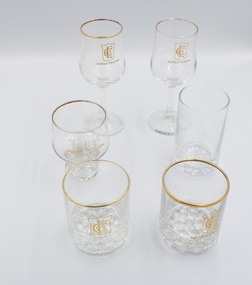
Functional object - Drinking glasses, 1983-1995
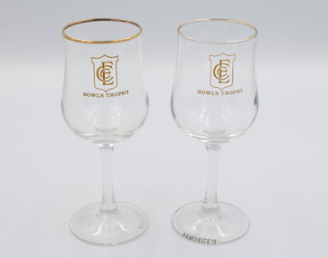
... facilities. It played an important role in the local community as it attracted state, national and international visitors for special sporting events and regular recreation. These glasses were bowls trophies presented to Doreen Ball for success in singles or team events between 1983 and 1995 The six glasses are artefacts from the Emerald Country Club which was an iconic part of the Emerald community for around 90 years. It contributed to and played a major role in the social ...The Emerald Country Club operated from the late 1920s until around 2010 on the northern section of the land previously occupied by Gembrook Nurseries. The building was modelled on American country clubs of the time. The Club's profile included a golf club and a bowls club serviced by a club house that provided meeting and eating facilities. It played an important role in the local community as it attracted state, national and international visitors for special sporting events and regular recreation. These glasses were bowls trophies presented to Doreen Ball for success in singles or team events between 1983 and 1995The six glasses are artefacts from the Emerald Country Club which was an iconic part of the Emerald community for around 90 years. It contributed to and played a major role in the social and sporting profile of the district.Six decorative clear drinking glasses awarded as prizes by the Emerald Country Club. "Emerald Country Club" with associated logoemerald, emerald country club, emerald country club and golf course, sports, trophy, glassware -
 Emerald Museum & Nobelius Heritage Park
Functional object - Wine glasses, 1983-1995
... facilities. It played an important role in the local community as it attracted state, national and international visitors for special sporting events and regular recreation. These wine glasses were awarded as prizes to Doreen Ball for successes in singles or teams bowls events between 1983-1995. The six glasses are artefacts from the Emerald Country Club which was an iconic part of the Emerald community for around 90 years. It contributed to and played a major role in the social ...The Emerald Country Club operated from the late 1920s until around 2010 on the northern section of the land previously occupied by Gembrook Nurseries. Its profile included a golf club and a bowls club serviced by a club house that provided meeting and eating facilities. It played an important role in the local community as it attracted state, national and international visitors for special sporting events and regular recreation. These wine glasses were awarded as prizes to Doreen Ball for successes in singles or teams bowls events between 1983-1995.The six glasses are artefacts from the Emerald Country Club which was an iconic part of the Emerald community for around 90 years. It contributed to and played a major role in the social and sporting profile of the district.Two wine glasses awarded as prizes by the Emerald Country Club. On bowl: 'ECC' / BOWLS TROPHY' Under base: ' FRANCE LUMINARE'emerald, emerald country club, emerald country club and golf course, sports, trophy, glassware, bowls -
 Emerald Museum & Nobelius Heritage Park
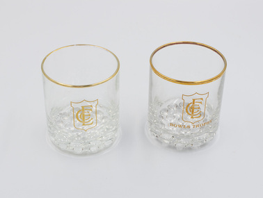
Functional object - Two drinking glasses, 1980s-1990s
... facilities. It played an important role in the local community as it attracted state, national and international visitors for special sporting events and regular recreation. These glasses were awarded as prizes to Doreen Ball for successes in bowls singles or team events between 1983-1995. These glasses are artefacts from the Emerald Country Club which was an iconic part of the Emerald community for around 90 years. It contributed to and played a major role in the social ...The Emerald Country Club operated from the late 1920s until around 2010 on the northern section of the land previously occupied by Gembrook Nurseries. Its profile included a golf club and a bowls club serviced by a club house that provided meeting and eating facilities. It played an important role in the local community as it attracted state, national and international visitors for special sporting events and regular recreation. These glasses were awarded as prizes to Doreen Ball for successes in bowls singles or team events between 1983-1995.These glasses are artefacts from the Emerald Country Club which was an iconic part of the Emerald community for around 90 years. It contributed to and played a major role in the social and sporting profile of the district.Two short, squat trophy glasses with 'bubble' base and gold rim. On bowl: 'ECC / BOWLS TROPHY'emerald, emerald country club, emerald country club and golf course, sports, trophy, glassware, bowls -
 Emerald Museum & Nobelius Heritage Park
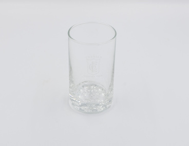
Functional object - Drinking glass
... facilities. It played an important role in the local community as it attracted state, national and international visitors for special sporting events and regular recreation. This glass is part of a group of six glasses - the other five are clearly marked as trophy glasses but not this one. This glass is an artefact from the Emerald Country Club which was an iconic part of the Emerald community for around 90 years. It contributed to and played a major role in the social ...The Emerald Country Club operated from the late 1920s until around 2010 on the northern section of the land previously occupied by Gembrook Nurseries. Its profile included a golf club and a bowls club serviced by a club house that provided meeting and eating facilities. It played an important role in the local community as it attracted state, national and international visitors for special sporting events and regular recreation. This glass is part of a group of six glasses - the other five are clearly marked as trophy glasses but not this one.This glass is an artefact from the Emerald Country Club which was an iconic part of the Emerald community for around 90 years. It contributed to and played a major role in the social and sporting profile of the district.One tall, plain drinking glass with 'bubble' base and Emerald Country Club logo on the side. "Emerald Country Club" with associated logoemerald, emerald country club, emerald country club and golf course, sports, trophy, glassware -
 Emerald Museum & Nobelius Heritage Park
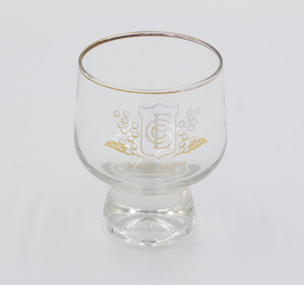
Functional object - Drinking glass with short stem, c.1980s-1990s
... facilities. It played an important role in the local community as it attracted state, national and international visitors for special sporting events and regular recreation. This was awarded to Doreen Ball for success in a bowls competition between 1983 and 1995. This glass is an artifact from the Emerald Country Club which was an iconic part of the Emerald community for around 90 years. It contributed to and played a major role in the social ...The Emerald Country Club operated from the late 1920s until around 2010 on the northern section of the land previously occupied by Gembrook Nurseries. Its profile included a golf club and a bowls club serviced by a club house that provided meeting and eating facilities. It played an important role in the local community as it attracted state, national and international visitors for special sporting events and regular recreation. This was awarded to Doreen Ball for success in a bowls competition between 1983 and 1995.This glass is an artifact from the Emerald Country Club which was an iconic part of the Emerald community for around 90 years. It contributed to and played a major role in the social and sporting profile of the district.One clear drinking glass, squat, round shape, gold-rimmed with a short stem, awarded as a prize by the Emerald Country Club. "BOWLS TROPHY" with associated ECC logo on the bowlemerald, emerald country club, emerald country club and golf course, sports, trophy, glassware