Showing 9574 items matching " south road"
-
 City of Kingston
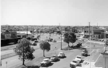
Photograph - Digital image, Black and white, Roads - Junction of Nepean Highway and South Road, c. 1950
... Roads - Junction of Nepean Highway and South Road......South Road...Junction of Nepean Highway and South Road, Moorabbin - Moorabbin Hotel on right. ...Black and white image of Nepean Highway and South Road junction point of view from Kingston Town Hall...Printed in black text a round white sticker: 234 Handwritten in red ink 80% Yellow post it note written in blue ink: CHAP 7 234 / - Nepean Hwy + South Road...Shops in centre demolished for road widening in 1980's Nepean Highway South Road Moorabbin Moorabbin Hotel Printed in black text a round white sticker: 234 Handwritten in red ink 80% Yellow post it note written in blue ink: CHAP 7 234 / - Nepean Hwy + South Road Black and white image of Nepean Highway and South Road junction point of view from Kingston Town Hall Roads - Junction of Nepean Highway and South Road Photograph Digital image, Black and white ...Junction of Nepean Highway and South Road, Moorabbin - Moorabbin Hotel on right. Shops in centre demolished for road widening in 1980'sBlack and white image of Nepean Highway and South Road junction point of view from Kingston Town HallPrinted in black text a round white sticker: 234 Handwritten in red ink 80% Yellow post it note written in blue ink: CHAP 7 234 / - Nepean Hwy + South Roadnepean highway, south road, moorabbin, moorabbin hotel -
 Sunshine and District Historical Society Incorporated
Document - South Road Housing Estate Project Report / Peter Lovell / Susan Oliver Report, Oliver, Susan et al, 29252
... South Road Housing Estate Project Report / Peter Lovell / Susan Oliver Report...South Road...The document is a report of recommendations on the rehabilitation of the South Road Estate in Sunshine, prepared for The Railway Construction Board, by Susan Oliver (Building Economist) and Peter Lovell (Building Consultant) on February 1980. ...South Road Braybrook House The document is a report of recommendations on the rehabilitation of the South Road Estate in Sunshine, prepared for The Railway Construction Board, by Susan Oliver (Building Economist) and Peter Lovell (Building Consultant) on February 1980. ...south road, braybrook, house -
 Kew Historical Society Inc
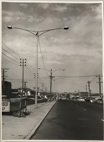
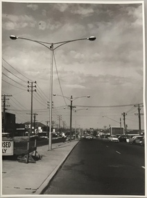
Photograph, Stuart Tompkins Studio, Electricity Supply Poles, South Road, Moorabbin, 1965
... Electricity Supply Poles, South Road, Moorabbin...stuart tompkins studio, street lighting, south road (moorabin) 1965...Electricity Supply Poles, South Road, Moorabbin, 1965. Stuart Tompkins Studio provided this photograph for the Kew City Council. ...Photographed for Kew City Council 8/2/65. No.2 South Road - Moorabbin, west of Jasper Road, looking east. ...Photographed for Kew City Council 8/2/65. No.2 South Road - Moorabbin, west of Jasper Road, looking east. ...Research provided by Stuart Tompkins Studio, Box Hill, into alternatives for median strip street lighting to be used in Burke Road, Kew. The photographers identified variants in different suburbs appropriate to Kew's needs.The series from which the photograph is drawn provides a snapshot by a commercial photographic studio of each named vicinity in 1965 as well as providing examples of public works infrastructure being commissioned by local government in the 1960s. The photos originally formed part of the Engineering Department's files in the City of Kew before being donated to the kew Historical Society.Electricity Supply Poles, South Road, Moorabbin, 1965. Stuart Tompkins Studio provided this photograph for the Kew City Council. The photograph of South Road, Moorabbin, west of Jasper Road, looking east depicts steel poles with two lamps in a median strip and supply wires from pole to pole. The poles were described as 100′ apart. The notation on the rear of the photograph was that there were lamps along the median strip except at intersections. A wooden pole is recognised as supporting heavy supply lines across the road. The steel poles in the photograph were said to be between 3′ to 3.5′ whereas the wooden poles were three to 12.25″ in diameter. [There are three copies of this photograph in the Collection.] Typed inscription on reverse: "Electricity Supply Poles. Photographed for Kew City Council 8/2/65. No.2 South Road - Moorabbin, west of Jasper Road, looking east. Steel poles with two lamps in median strip and supply wires from pole to pole along median strip (poles only 100' apart). Lamps along median only except at intersections. Wooden pole supports heavy supply lines across the road. Wooden poles 3' up and 8 1/2" dia. Wooden poles 3' up and 12 1/2 dia." Studio stamp: "Stuart Tompkins Studio. 547 Station Street, Box Hill. WX1439."stuart tompkins studio, street lighting, south road (moorabin) 1965, public infrastructure -- city of kew, city of kew -- engineer's department -
 Sunshine and District Historical Society Incorporated
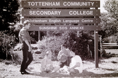
Photograph - Tottenham Community Secondary College South Road Braybrook 1991 Photograph, Sharon Cavanagh, 13th March 191
... Tottenham Community Secondary College South Road Braybrook 1991 Photograph......South Road...Tottenham Community Secondary College South Road Braybrook SRC On The Multi Complex Campus Sunshine Secondary College South Rd Braybrook Tottenham Community Secondary College Tottenham English Language Centre Sunshine SDS Annexe Digital scan of black and white negative Photograph Tottenham Community Secondary College South Road Braybrook 1991 Photograph Sharon Cavanagh The Sunshine Advocate ...Tottenham Community Secondary College was the final name of Tottenham Technical School, operating from 1957 to 1991, before being merged into Sunshine Secondary College. Its former campus is now the Tottenham English Language Centre, which continues to operate on the same site.SRC On The Multi Complex Campus Sunshine Secondary College South Rd Braybrook Tottenham Community Secondary College Tottenham English Language Centre Sunshine SDS Annexetottenham community secondary college, south road, braybrook -
 Sunshine and District Historical Society Incorporated
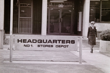
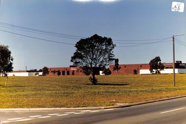
Photograph - RAAF No 1 Stores Depot South Road Braybrook Site Tour 1990 Photograph, C. McGee, 17th June 1991
... RAAF No 1 Stores Depot South Road Braybrook Site Tour 1990 Photograph......South Road...RAAF No 1 Store South Road Braybrook R.A.A.F. Base Tour 285.1 Digital scans of black and white negatives Photograph RAAF No 1 Stores Depot South Road Braybrook Site Tour 1990 Photograph C. ...No. 1 RAAF Stores Depot in Braybrook (often called the Tottenham RAAF Stores Depot) was one of the most important defence facilities in Melbourne’s west, a massive wartime logistics base built in 1944–45 and operated until 1993. The site expanded significantly after WWII, adding: RAAF Police Dog Training Centre (established 1962), supply‑officer training facilities, accommodation blocks, mess halls, chapels, gyms and sports grounds which transformed the depot into a self‑contained military community. It shaped Braybrook’s industrial landscape, employed hundreds of locals, and played a central role in Australia’s WWII and post‑war supply chain. These photographs capture only a small part of the No. 1 RAAF Stores Depot that one of Australia’s major wartime and post‑war defence logistics centres, representing the scale, organisation, and industrial capability required to support the Royal Australian Air Force from 1945 to 1993. Established during the critical final years of the Second World War, the depot consolidated dozens of scattered storage sites into a single purpose‑built facility, demonstrating the Commonwealth’s shift toward modern, centralised military supply systems. Its extensive warehouses, rail sidings, and specialised training areas illustrate mid‑20th‑century defence planning and the functional architectural style of the Department of Works. The depot played a vital role in national logistics, handling equipment, clothing, barracks stores, demobilisation materials, and returned overseas supplies. It was also a major employer in Melbourne’s western suburbs, shaping the social and economic life of Braybrook, Sunshine, and Tottenham for nearly five decades. The presence of the RAAF Police Dog Training Centre further highlights the site’s operational diversity and long‑term importance to defence readiness. Although most of the depot has been demolished, the surviving guard house and office block on Ashley Street remain as rare physical evidence of a once‑vast military complex. The depot’s legacy endures in the urban form of Braybrook and in the community memory of the thousands who worked there. Its significance lies in its contribution to Australia’s defence history, its impact on the development of Melbourne’s west, and its representation of large‑scale wartime infrastructure.R.A.A.F. Base Tour 285.1raaf no 1 store, south road, braybrook -
 Kew Historical Society Inc
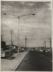
Photograph, Stuart Tompkins Studio, Electricity Supply Poles, South Road, Moorabbin, 1965
... Electricity Supply Poles, South Road, Moorabbin...Electricity Supply Poles, South Road, Moorabbin, 1965. Stuart Tompkins Studio provided this photograph for the Kew City Council. ...Photographed for Kew City Council 8/2/65. No.2 South Road - Moorabbin, west of Jasper Road, looking east. ...Photographed for Kew City Council 8/2/65. No.2 South Road - Moorabbin, west of Jasper Road, looking east. ...Research provided by Stuart Tompkins Studio, Box Hill, into alternatives for median strip street lighting to be used in Burke Road, Kew. The photographers identified variants in different suburbs appropriate to Kew's needs.The series from which the photograph is drawn provides a snapshot by a commercial photographic studio of each named vicinity in 1965 as well as providing examples of public works infrastructure being commissioned by local government in the 1960s. The photos originally formed part of the Engineering Department's files in the City of Kew before being donated to the kew Historical Society.Electricity Supply Poles, South Road, Moorabbin, 1965. Stuart Tompkins Studio provided this photograph for the Kew City Council. The photograph of South Road, Moorabbin, west of Jasper Road, looking east depicts steel poles with two lamps in a median strip and supply wires from pole to pole. The poles were described as 100′ apart. The notation on the rear of the photograph was that there were lamps along the median strip except at intersections. A wooden pole is recognised as supporting heavy supply lines across the road. The steel poles in the photograph were said to be between 3′ to 3.5′ whereas the wooden poles were three to 12.25″ in diameter. [There are three copies of this photograph in the Collection.] Typed inscription on reverse: "Electricity Supply Poles. Photographed for Kew City Council 8/2/65. No.2 South Road - Moorabbin, west of Jasper Road, looking east. Steel poles with two lamps in median strip and supply wires from pole to pole along median strip (poles only 100' apart). Lamps along median only except at intersections. Wooden pole supports heavy supply lines across the road. Wooden poles 3' up and 8 1/2" dia. Wooden poles 3' up and 12 1/2 dia." Studio stamp: "Stuart Tompkins Studio. 547 Station Street, Box Hill. WX1439."public infrastructure -- kew (vic.), city of kew - engineers department -
 Kew Historical Society Inc
Photograph, Stuart Tompkins Studio, Electricity Supply Poles, South Road, Moorabbin, 1965
... Electricity Supply Poles, South Road, Moorabbin...Electricity Supply Poles, South Road, Moorabbin, 1965. Stuart Tompkins Studio provided this photograph for the Kew City Council. ...Photographed for Kew City Council 8/2/65. No.2 South Road - Moorabbin, west of Jasper Road, looking east. ...Photographed for Kew City Council 8/2/65. No.2 South Road - Moorabbin, west of Jasper Road, looking east. ...Research provided by Stuart Tompkins Studio, Box Hill, into alternatives for median strip street lighting to be used in Burke Road, Kew. The photographers identified variants in different suburbs appropriate to Kew's needs.The series from which the photograph is drawn provides a snapshot by a commercial photographic studio of each named vicinity in 1965 as well as providing examples of public works infrastructure being commissioned by local government in the 1960s. The photos originally formed part of the Engineering Department's files in the City of Kew before being donated to the kew Historical Society.Electricity Supply Poles, South Road, Moorabbin, 1965. Stuart Tompkins Studio provided this photograph for the Kew City Council. The photograph of South Road, Moorabbin, west of Jasper Road, looking east depicts steel poles with two lamps in a median strip and supply wires from pole to pole. The poles were described as 100′ apart. The notation on the rear of the photograph was that there were lamps along the median strip except at intersections. A wooden pole is recognised as supporting heavy supply lines across the road. The steel poles in the photograph were said to be between 3′ to 3.5′ whereas the wooden poles were three to 12.25″ in diameter. [There are three copies of this photograph in the Collection.] Typed inscription on reverse: "Electricity Supply Poles. Photographed for Kew City Council 8/2/65. No.2 South Road - Moorabbin, west of Jasper Road, looking east. Steel poles with two lamps in median strip and supply wires from pole to pole along median strip (poles only 100' apart). Lamps along median only except at intersections. Wooden pole supports heavy supply lines across the road. Wooden poles 3' up and 8 1/2" dia. Wooden poles 3' up and 12 1/2 dia." Studio stamp: "Stuart Tompkins Studio. 547 Station Street, Box Hill. WX1439."city of kew -- engineers department, public infrastructure -- kew (vic.) -
 City of Kingston
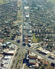
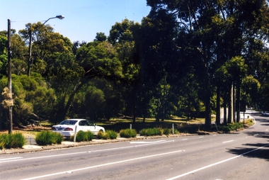
Photograph - Colour, c. 1982
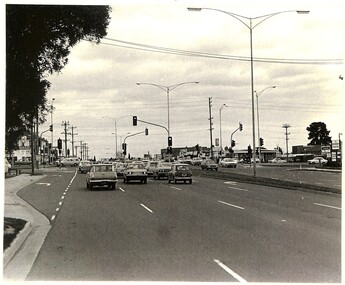
... ...South Road...This aerial photograph of South Road and Nepean Highway, Moorabbin shows the area where houses and shops on the south side of the Nepean Highway have demolished for the widening of the highway. ...Colour photograph of an aerial view of South Road and Nepean Highway, Moorabbin. The image shows houses on the south side of the Nepean Highway that have demolished for widening of road. ...Nepean Highway South Road Moorabbin Roads Transport Infrastructure Handwritten blue ink: 82 - 5452 - 11 Handwritten red ink: 112% Handwritten black ink: Ch. 7 Colour photograph of an aerial view of South Road and Nepean Highway, Moorabbin. ...This aerial photograph of South Road and Nepean Highway, Moorabbin shows the area where houses and shops on the south side of the Nepean Highway have demolished for the widening of the highway. The pressures of rapid urban development in Moorabbin and beyond, especially to the south of Moorabbin caused bottlenecks and delays, especially at the South Road and Nepean Highway intersection, hence the scheme to widen Nepean Highway.The pressures of rapid urban development in terms of people, housing construction, industrial development and commercial activity, in Moorabbin and beyond, especially to the south would put pressure on road infrastructure in the region. In the early 1980s, a major road expansion of the Nepean Highway was implemented to increase capacity on this major thoroughfare for vehicle commuters. Car use had also increased with commuters from the increasingly populous southern suburbs travelling to their place of work in the Melbourne CBD.Colour photograph of an aerial view of South Road and Nepean Highway, Moorabbin. The image shows houses on the south side of the Nepean Highway that have demolished for widening of road. It features housing and commercial buildings looking north towards Cummins Road.Handwritten blue ink: 82 - 5452 - 11 Handwritten red ink: 112% Handwritten black ink: Ch. 7nepean highway, south road, moorabbin, roads, transport, infrastructure -
 Greensborough Historical Society
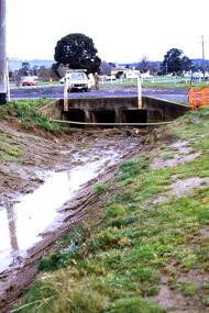
Slide - Photograph, John Ramsdale, Near Plenty Road South Morang: Slide 53, 1990s
... Near Plenty Road South Morang: Slide 53...plenty road south morang...Photograph shows drain and culvert near Plenty Road South Morang....Greensborough Historical Society 34A Glenauburn Road Lower Plenty Lower Plenty melbourne Photograph shows drain and culvert near Plenty Road South Morang. Part of the John Ramsdale collection of slides and audio visual material. plenty road south morang No maker's marks. ...Photograph shows drain and culvert near Plenty Road South Morang.Part of the John Ramsdale collection of slides and audio visual material.Colour photograph scanned from slide.No maker's marks. No caption on slide.plenty road south morang -
 Melbourne Tram Museum
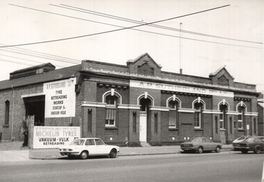
Photograph - City Road South Melbourne cable tram engine house, 1960s
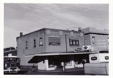
... City Road South Melbourne cable tram engine house......South Melbourne...City Road...Photos shows the exterior of the former cable tram engine house at 357 City Road South Melbourne. It operated from 1890 to 1937. ...Photograph City Road South Melbourne cable tram engine house ...Photos shows the exterior of the former cable tram engine house at 357 City Road South Melbourne. It operated from 1890 to 1937. At the time the building was occupied by A P Sutherland, tyre retreaders. Has an advert for Michelin tyres. Photo early 1960s based on the motor vehicles, photographer unknown. Following a fire in the building it was redeveloped as offices with the facade remaining in position.Yields information about the appearance the former South Melbourne cable tram engine house.Black and white print with a plain back. Second copy has notes on rear and a letraset label on base."South Melbourne Cable tram engine house C Cibson Photo" in ink on rear.tramways, cable trams, engine houses, south melbourne, city road -
 Eltham District Historical Society Inc
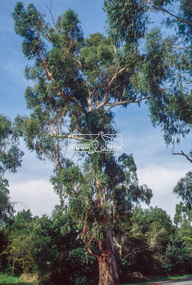
Slide - Photograph, Manna Gum, Main Road, Eltham South, c.Apr. 1993
... Manna Gum, Main Road, Eltham South...south...main road...Estimated to date from 1870-180, this large Manna Gum (now deceased 2022) on the northern side of Main Road just south of the Main Road Bridge over the Diamond Creek, Eltham South, c.1993. ...Diamond Creek Trail can be see on opposite side of the road. eltham south main road significant tree Main Road Bridge Manna Gum Process Date "Apr M" 35mm colour positive transparency (1 of 22) Mount - Kodak Ektachrome Manna Gum, Main Road, Eltham South Slide Photograph ...Estimated to date from 1870-180, this large Manna Gum (now deceased 2022) on the northern side of Main Road just south of the Main Road Bridge over the Diamond Creek, Eltham South, c.1993. Diamond Creek Trail can be see on opposite side of the road. 35mm colour positive transparency (1 of 22) Mount - Kodak EktachromeProcess Date "Apr M"eltham south, main road, significant tree, main road bridge, manna gum -
 Melbourne Tram Museum
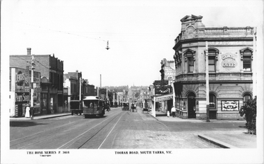
Postcard, Rose Stereograph Co, "Toorak Road South Yarra Vic", c1922
... "Toorak Road South Yarra Vic"...Road...South Yarra..."Toorak Road South Yarra Vic" Postcard Rose Stereograph Co. ...Rose Series postcard P.3614 of Toorak Road looking east across Punt Road. Has four cable trams in the view along with horse-drawn carts. There is an early style "Hail Cars Here" sign on the pole in the left of the photo. Adverts for Dewars. Pears soap, Cadburys, and Carlton Ale. Yields information about Toorak Road early1920'sPostcard - printed real photograph with Rose Stereograph Co. name on the rear.Has the Ken Magor stamp on the reartrams, tramways, cable trams, toorak road, south yarra, punt road, rose series, tram stops -
 Eltham District Historical Society Inc
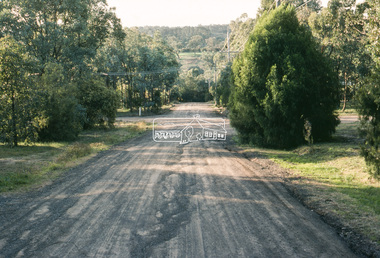
Slide - Photograph, Eltham South Road, c. Jun 1981
... Eltham South Road...Many roads of the shire were only relatively recently sealed towards the late 1980s/early 1990s. infrastructure roads main road eltham footpaths and gutters Unidentified Processed July 1981 35 mm colour positive transparency (1 of 8) Mount - Kodak Kodachrome Card Eltham South Road Slide Photograph ...Roll of film taken by Eltham Shire Council officers specifically focussed on road infrastructure and maintenance. Many roads of the shire were only relatively recently sealed towards the late 1980s/early 1990s.35 mm colour positive transparency (1 of 8) Mount - Kodak Kodachrome CardProcessed July 1981infrastructure, roads, main road, eltham, footpaths and gutters, unidentified -
 Kingston Arts
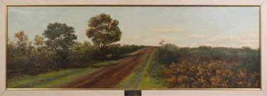
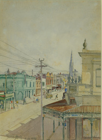
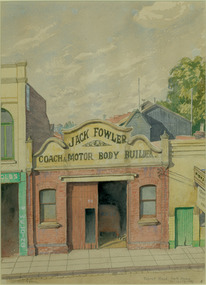
Painting, Edith Slaney, South Road near Bignell Road - Moorabbin, 1903
... South Road near Bignell Road - Moorabbin...Kingston Arts 979 Nepean Hwy (Cnr South Road and Nepean Hwy, 100 metres from Moorabbin train station) Moorabbin melbourne South Road near Bignell Road - Moorabbin Painting Edith Slaney ... -
 Whitehorse Historical Society Inc.
Photograph, Blackburn Road, South Blackburn, 2012
... Blackburn Road, South Blackburn...road...blackburn south...Whitehorse Historical Society Inc. 2-10 Deep Creek Road Mitcham melbourne See NP4006 blackburn road blackburn south canterbury road blackburn south Coloured photograph of Blackburn Road heading north from Canterbury Road toward Blackburn Blackburn Road, South Blackburn Photograph Photograph ...See NP4006Coloured photograph of Blackburn Road heading north from Canterbury Road toward Blackburnblackburn road, blackburn south, canterbury road blackburn south -
 Whitehorse Historical Society Inc.
Photograph, Land in Livingstone Road, South Vermont
... Land in Livingstone Road, South Vermont....Coloured photo of Land in Livingstone Road, South Vermont....Whitehorse Historical Society Inc. 2-10 Deep Creek Road Mitcham melbourne To Be Entered Coloured photo of Land in Livingstone Road, South Vermont. Land in Livingstone Road, South Vermont. ...Coloured photo of Land in Livingstone Road, South Vermont.to be entered -
 Whitehorse Historical Society Inc.
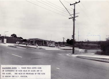
Photograph - Black and white photo, South side of Canterbury Road, Blackburn South, 9/11/1962 12:00:00 AM
... South side of Canterbury Road, Blackburn South....Black and white photo taken from South side of Canterbury Road with Main Street going off to the right. ...Blackburn South. South side of Canterbury Road, Blackburn South. Photograph Black and white photo ...Black and white photo taken from South side of Canterbury Road with Main Street going off to the right. Blackburn South.blackburn fibrous plaster works, industries -
 Glen Eira Historical Society
Document - Brighton Cemetery, North Road, Caulfield South
... Brighton Cemetery, North Road, Caulfield South...South... North Road...North Road, Caulfield South, Victoria, Australia...Miller Mausoleum Brighton Cemetery Caulfield South North Road Ward Andrew Miller Septimus Miller Clara Johnstone Miller Gwendoline Stewart Cantala Dandenong Road Cemeteries Graves Tombstones Gravestones Monuments and memorials Architectural styles Gothic (revival) architecture Architectural features Gables Roofs Windows Document Brighton Cemetery, North Road, Caulfield South ...Photocopy of the entry in the Caulfield Conservation Study, dated 01/1995, by Andrew Ward for the Miller Mausoleum at Brighton Cemetery. The study includes a description of the tomb’s architectural features, a brief history and a photograph of the tomb.miller mausoleum, brighton cemetery, caulfield south, north road, ward andrew, miller septimus, miller clara johnstone, miller gwendoline stewart, cantala, dandenong road, cemeteries, graves, tombstones, gravestones, monuments and memorials, architectural styles, gothic (revival) architecture, architectural features, gables, roofs, windows -
Glen Eira Historical Society
Article - St. Catherine’s Church of England, Kooyong Road, Caulfield South
... Catherine’s Church of England, Kooyong Road, Caulfield South...South... Kooyong Road...Kooyong Road, Caulfield South, Victoria, Australia...Catharine’s Church of England Caulfield South Kooyong Road Clarence Street Stephens Mr. Debb Dr. ...Three items about this Church: 1/St. Catherine’s Parish paper, February 1924. 2/Baptismal prayer card for Harry Norman Bromfield 08/03/1925. 3/Carbon typed copy of document detailing inscriptions in St. Catherine’s Anglican Church Caulfield.st. catherine’s church of england, st. catharine’s church of england, caulfield south, kooyong road, clarence street, stephens mr., debb dr., murphy mr., booth e., masters p., kindergartens, paterson mrs., fowler mrs., capper mrs., mayes mrs., olley mrs., hosken mrs., schwieger miss, walker mrs., ward mrs., foster mrs., marshall mrs., marsh mrs., hearn miss, stephens h., downshire road, bromfield harry norman, taylor alice mary, wigg catherine elizabeth, stephens grace m., beagley emily a., beagley joseph e., beagley emily ada, parrott frances catherine, wilson alfred roscoe, hamilton flora, hillard john beattie, hillard thomas, haillard eliza, barlow w., begbie a.h., cole s., love j., north h., tonks h., scammell s., hunt geoffrey donald, myer leslie robert irvine, forbes betty, mcavoy alan robert, humphreys betty grace, marke alfred robert, bromfield norman edward, reed margery eva, philpot elizabeth ann, dillow henry thomas, murphy mr., taylor mr., booth mr., drewett mr., hickson mr., ingram mr., lumsden mr., meyer mr., nutt mr., summerhayes mr., mcclure j., segal boris -
 Sunshine and District Historical Society Incorporated
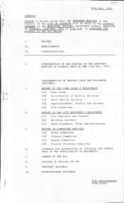
Administrative record - City of Sunshine - Commissioner Mr Alexander Alex George Gillon Collection 1976 - 1982 - Notice of ordinary meeting of the council 26th May 2026, City of Sunshine, 20th May 1981
... ...South Road...Italo-Australian Social Club proposal to sub-lease Elderly Persons Units South Road Housing Estate (Former Quarry Showers Street)...Italo-Australian Social Club Furlong Road St. Albans South Road Showers Street Braybrook Italo-Australian Social Club proposal to sub-lease Elderly Persons Units South Road Housing Estate (Former Quarry Showers Street) Foolscap sized document. ...Italo-Australian Social Club proposal to sub-lease Elderly Persons Units South Road Housing Estate (Former Quarry Showers Street)italo-australian social club, furlong road, st. albans, south road, showers street, braybrook -
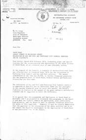 Sunshine and District Historical Society Incorporated
Letter - City of Sunshine - Commissioner Mr Alexander Alex George Gillon Collection 1976 - 1982 - Extraordinary business 10th December 1974, Country Road Board Victoria, 10th December 1974
... South Road...South Road Ashley Street to Rochester Street relocation of Gas & Fuel and Footscray City Council Services for reconstruction and duplication of the above section of road...South Road Ashley Street Rochester Street Braybrook South Road Ashley Street to Rochester Street relocation of Gas & Fuel and Footscray City Council Services for reconstruction and duplication of the above section of road Foolscap sized document. ...South Road Ashley Street to Rochester Street relocation of Gas & Fuel and Footscray City Council Services for reconstruction and duplication of the above section of roadsouth road, ashley street, rochester street, braybrook -
 Tatura Irrigation & Wartime Camps Museum
Painting - Painting - Watercolour, Toorak Road, South Yarra
... Toorak Road, South Yarra......Toorak Road South Yarra VIC...Leonhard Adam Toorak Road South Yarra VIC Toorak Road, South Yarra Painting Painting - Watercolour ...Done by Leonhard Adam, an internee in Tatura.leonhard adam, toorak road south yarra vic -
 Tatura Irrigation & Wartime Camps Museum
Painting - Painting - Watercolour, Toorak Road, South Yarra, Sept 12-14, 1943
... Toorak Road, South Yarra, Sept 12-14, 1943......Toorak Road South Yarra...Tatura Irrigation & Wartime Camps Museum 49 Hogan Street Tatura the-murray By Leonhard Adam Leonhard Adam Toorak Road South Yarra Toorak Road, South Yarra, Sept 12-14, 1943 Painting Painting - Watercolour ...By Leonhard Adamleonhard adam, toorak road south yarra -
 Whitehorse Historical Society Inc.
Photograph, Springvale Road looking South, 1/09/1983 12:00:00 AM
... Springvale Road looking South...Black and white photo of Springvale Road looking South. Intersects with Whitehorse Road, Nunawading....Springvale Road looking South Photograph Photograph ...Donor developed Educational Programme at Blackburn Lake.Black and white photo of Springvale Road looking South. Intersects with Whitehorse Road, Nunawading.meagher, dorothy, springvale road, nunawading, whitehorse road, nunawading -
 Melbourne Tram Museum
Photograph - Black and White - St Kilda Road, looking south to St Kilda Junction
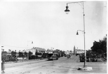
... Black and White - St Kilda Road, looking south to St Kilda Junction...St Kilda Road, looking south to St Kilda Junction from near Peel Street. ...Black and white photograph - St Kilda Road, looking south to St Kilda Junction, c1900. ...Melbourne Tram Museum 8 Wallen Road Hawthorn melbourne St Kilda Road, looking south to St Kilda Junction from near Peel Street. ...St Kilda Road, looking south to St Kilda Junction from near Peel Street. Photo shows a number of horse drawn vehicles and one cable tram on its way to St Kilda Beach. In the background is the Junction Hotel and the Corner Hotel advertising Black and White whiskey. There are a number of gas street lamps in the view.Yields information about St Kilda Road and St Kilda Junction about 1900.Black and white photograph - St Kilda Road, looking south to St Kilda Junction, c1900. Two copies held.tramways, trams, st kilda road, st kilda junction, cable trams, corner hotel, junction hotel -
 Whitehorse Historical Society Inc.
Photograph, Corner South Parade & Blackburn Road, Blackburn, 1/06/1969 12:00:00 AM
... Corner South Parade & Blackburn Road, Blackburn...south parade blackburn...blackburn road...Black and white photo of corner Blackburn Road and South Parade, Blackburn....Corner South Parade & Blackburn Road, Blackburn Photograph Photograph ...Black and white photo of corner Blackburn Road and South Parade, Blackburn.south parade blackburn, blackburn road -
 City of Kingston
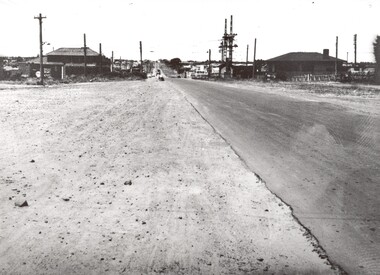
Photograph - Black and white, c. 1950
... This image shows a sealed road running along South Road, although with a wide gravel shoulder. ...Black and white photograph of the railway crossing at South Road, Moorabbin, viewed from Nepean Highway. ...City of Kingston Parkdale Library 96 Parkers Road, Parkdale Parkdale This image shows a sealed road running along South Road, although with a wide gravel shoulder. ...This image shows a sealed road running along South Road, although with a wide gravel shoulder. The railway crossing gates were hand operated. This image is one of many in the collections that focuses on the railway. The development of the railway was crucial to the ongoing development of the area. Community life often sprang up along and beside the railway.Black and white photograph of the railway crossing at South Road, Moorabbin, viewed from Nepean Highway. Handwritten in blue ink on reverse: 217 Handwritten in red ink on reverse: 80%moorabbin, railway, railway crossing -
 Eltham District Historical Society Inc
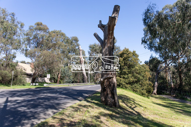
Photograph, Peter Pidgeon, Manna Gum, Main Road, Eltham South, 8 Sep. 2021
... Manna Gum, Main Road, Eltham South...South...main road bridge...Road Bridge over the Diamond Creek at Eltham dates back to approximately 1870-1880. Though dead now, its trunk has been left as a wildlife habitat. These trees are not only significant for the natural environment but also present a navigational beacon back in time as the environmental landscape is developed around them. Eltham South ...This significant tree located near the Main Road Bridge over the Diamond Creek at Eltham dates back to approximately 1870-1880. Though dead now, its trunk has been left as a wildlife habitat.These trees are not only significant for the natural environment but also present a navigational beacon back in time as the environmental landscape is developed around them.Born Digitaleltham south, main road bridge, manna gum, significant tree -
 Eltham District Historical Society Inc
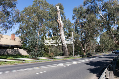
Photograph, Peter Pidgeon, Manna Gum, Main Road, Eltham South, 8 Sep. 2021
... Manna Gum, Main Road, Eltham South...south...main road bridge...Road Bridge over the Diamond Creek at Eltham dates back to approximately 1870-1880. Though dead now, its trunk has been left as a wildlife habitat. These trees are not only significant for the natural environment but also present a navigational beacon back in time as the environmental landscape is developed around them. eltham south main road bridge manna gum significant tree Born Digital Manna Gum, Main Road, Eltham South Photograph Photograph Peter Pidgeon ...This significant tree located near the Main Road Bridge over the Diamond Creek at Eltham dates back to approximately 1870-1880. Though dead now, its trunk has been left as a wildlife habitat.These trees are not only significant for the natural environment but also present a navigational beacon back in time as the environmental landscape is developed around them.Born Digitaleltham south, main road bridge, manna gum, significant tree -
 Eltham District Historical Society Inc
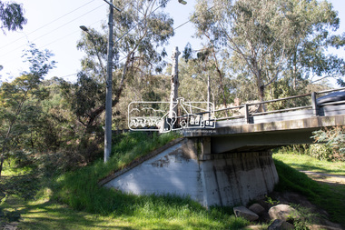
Photograph, Peter Pidgeon, Manna Gum, Main Road, Eltham South, 8 Sep. 2021
... Manna Gum, Main Road, Eltham South...south...main road bridge...Road Bridge over the Diamond Creek at Eltham dates back to approximately 1870-1880. Though dead now, its trunk has been left as a wildlife habitat. These trees are not only significant for the natural environment but also present a navigational beacon back in time as the environmental landscape is developed around them. eltham south main road bridge manna gum significant tree Born Digital Manna Gum, Main Road, Eltham South Photograph Photograph Peter Pidgeon ...This significant tree located near the Main Road Bridge over the Diamond Creek at Eltham dates back to approximately 1870-1880. Though dead now, its trunk has been left as a wildlife habitat.These trees are not only significant for the natural environment but also present a navigational beacon back in time as the environmental landscape is developed around them.Born Digitaleltham south, main road bridge, manna gum, significant tree