Showing 25 items matching " spring gully reservoir"
-
 Bendigo Regional Archives Centre
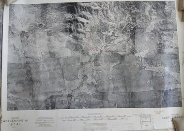
Photograph (item) - Set of 8 1945 B& W Photomaps, mounted on linen, most with geological annotations, as follows: Castlemaine A1, 817 A1, Zone 7, 1945; Bendigo A2 -Eaglehawk Aqueduct, Bullock Creek and Lockwood; Bendigo A4, 807 A4, Zone 7, 1945; Bendigo B1 - Golden Square, Kangaroo Flat, Splitters Creek, Strathfieldsaye Creek, Sheepwash Creek, Spring Gully Reservoir; Bendigo B3, 807 B3, Zone 7, 1945; Bendigo C3, 807 C3, Zone 7, 1945; Bendigo D3, 807 D3, Zone 7, 1945; Huntly C4 - Eaglehawk, Marong, Myers Flat, 1945
... Set of 8 1945 B& W Photomaps, mounted on linen, most with geological annotations, as follows: Castlemaine A1, 817 A1, Zone 7, 1945; Bendigo A2 -Eaglehawk Aqueduct, Bullock Creek and Lockwood; Bendigo A4, 807 A4, Zone 7, 1945; Bendigo B1 - Golden Square, Kangaroo Flat, Splitters Creek, Strathfieldsaye Creek, Sheepwash Creek, Spring Gully Reservoir; Bendigo B3, 807 B3, Zone 7, 1945; Bendigo C3, 807 C3, Zone 7, 1945; Bendigo D3, 807 D3, Zone 7, 1945; Huntly C4 - Eaglehawk, Marong, Myers Flat...Set of 8 1945 B& W Photomaps, mounted on linen, most with geological annotations, as follows: Castlemaine A1, 817 A1, Zone 7, 1945; Bendigo A2 -Eaglehawk Aqueduct, Bullock Creek and Lockwood; Bendigo A4, 807 A4, Zone 7, 1945; Bendigo B1 - Golden Square, Kangaroo Flat, Splitters Creek, Strathfieldsaye Creek, Sheepwash Creek, Spring Gully Reservoir; Bendigo B3, 807 B3, Zone 7, 1945; Bendigo C3, 807 C3, Zone 7, 1945; Bendigo D3, 807 D3, Zone 7, 1945; Huntly C4 - Eaglehawk, Marong, Myers Flat...Phtotomap Printed aerial photographs mounted on linen Set of 8 1945 B& W Photomaps, mounted on linen, most with geological annotations, as follows: Castlemaine A1, 817 A1, Zone 7, 1945; Bendigo A2 -Eaglehawk Aqueduct, Bullock Creek and Lockwood; Bendigo A4, 807 A4, Zone 7, 1945; Bendigo B1 - Golden Square, Kangaroo Flat, Splitters Creek, Strathfieldsaye Creek, Sheepwash Creek, Spring Gully Reservoir; Bendigo B3, 807 B3, Zone 7, 1945; Bendigo C3, 807 C3, Zone 7, 1945; Bendigo D3, 807 D3, Zone 7, 1945; Huntly C4 - Eaglehawk, Marong, Myers Flat Photograph Set of 8 1945 B& W Photomaps, mounted on linen, most with geological annotations, as follows: Castlemaine A1, 817 A1, Zone 7, 1945; Bendigo A2 -Eaglehawk Aqueduct, Bullock Creek and Lockwood; Bendigo A4, 807 A4, Zone 7, 1945; Bendigo B1 - Golden Square, Kangaroo Flat, Splitters Creek, Strathfieldsaye Creek, Sheepwash Creek, Spring Gully Reservoir; Bendigo B3, 807 B3, Zone 7, 1945; Bendigo C3, 807 C3, Zone 7, 1945; Bendigo D3, 807 D3, Zone 7, 1945; Huntly C4 - Eaglehawk, Marong, Myers Flat ...Phtotomap -
 Bendigo Historical Society Inc.
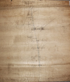
Plan - New Chum Goldfields Co. N.L, 20.7.1912
... ...Spring Gully Reservoir...New Chum Goldfield Co. was located at the Diamond Hill Road end of Spring Gully Reservoir. Latitude: -36.8114952741, Longitude: 144.2747542333 The location is now within the fenced area of the Spring Gully Reservoir, and not accessible. ...N.L. Spring Gully Reservoir New Chum Goldfields Mine longitudinal plan. ...New Chum Goldfield Co. was located at the Diamond Hill Road end of Spring Gully Reservoir. Latitude: -36.8114952741, Longitude: 144.2747542333 The location is now within the fenced area of the Spring Gully Reservoir, and not accessible. New Chum Goldfields Mine longitudinal plan. Written on plan 'W.H. Cundy, 20.7.12' Plan forms part of the Margaret Roberts Collection.gold mining, gold, bendigo, new chum goldfields co. n.l., spring gully reservoir -
 Bendigo Historical Society Inc.
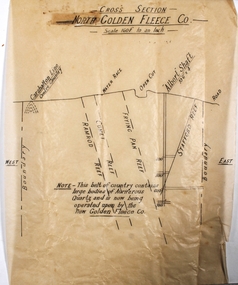
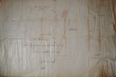
Plan - North Golden Fleece Mine
... ...Spring Gully Reservoir...North Golden Fleece Gold Mine was located approx. 1200m west of Spring Gully Reservoir, near Diamond Hill Road. ...North Golden Fleece Gold Mine was located approx. 1200m west of Spring Gully Reservoir, near Diamond Hill Road. Margaret Roberts gold gold mine Bendigo North Golden Fleece Gold Mine Spring Gully Reservoir Plan drawn on tan tissue paper, black text. ...North Golden Fleece Gold Mine was located approx. 1200m west of Spring Gully Reservoir, near Diamond Hill Road. Plan drawn on tan tissue paper, black text. Written across top of plan: 'Cross Section, North Golden Fleece Co. 160' to an inch'. Annotations on plan: Carshalton line, water race, open cut, Albert Shaft 10'6" x 4, road. East and West marked on plan. On bottom of plan: ' This belt of country contains large bodies of auriferous quartz and is now being operated upon by the New Golden Fleece Co.' Plan forms part of the Margaret Roberts Collection of mining records. margaret roberts, gold, gold mine, bendigo, north golden fleece gold mine, spring gully reservoir -
 Bendigo Historical Society Inc.
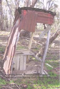
Photograph - DIAMOND HILL HISTORIC RESERVE - OLD TOILET
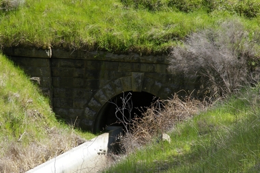
... ...Spring Gully Reservoir reserve...Colour photo of old corrugated iron toilet, taken near mine site in Spring Gully Reservoir Reserve ( Diamond Hill) Image shows wooden toilet frame, no sides left on toilet building and a lean of approx 10 degrees on the structure....History House 11 Mackenzie Street Bendigo goldfields BENDIGO Mining Spring Gully Reservoir reserve Colour photo of old corrugated iron toilet, taken near mine site in Spring Gully Reservoir Reserve ( Diamond Hill) Image shows wooden toilet frame, no sides left on toilet building and a lean of approx 10 degrees on the structure. ...Colour photo of old corrugated iron toilet, taken near mine site in Spring Gully Reservoir Reserve ( Diamond Hill) Image shows wooden toilet frame, no sides left on toilet building and a lean of approx 10 degrees on the structure.bendigo, mining, spring gully reservoir reserve -
 Bendigo Historical Society Inc.
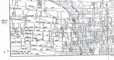
Map - LONG GULLY HISTORY GROUP COLLECTION: MAP OF REEFS AND MINES
... ... Spring Gully Reservoir...Two pages with lines of reef and mines from Spring Gully Reservoir to north of the Eaglehawk Railway Station. ...History House 11 Mackenzie Street Bendigo goldfields BHS Collection BENDIGO History long gully history group The Long Gully History Group - Map of Reefs and Mines Spring Gully Reservoir Thistle Carshalton Napoleon British & Foreign Nell Gwynne New Chum Sheepshead Deborah Garden Gully Paddy's Gully Derby Miller's Hustlers Lightning Hill Myers Flat Lancashire Cook's Maiden Gully Johnson's Millers Golden Square Railway Station Bendigo Railway Station Eaglehawk Railway Station Two pages with lines of reef and mines from Spring Gully Reservoir to north of the Eaglehawk Railway Station. ...BHS CollectionTwo pages with lines of reef and mines from Spring Gully Reservoir to north of the Eaglehawk Railway Station. Shown on the map are the lines of reef, the Thistle, Carshalton, Napoleon, British & Foreign, Nell Gwynne, New Chum, Sheepshead, Deborah, Garden Gully, Paddy's Gully, Derby, Miller's, Hustlers, Lightning Hill, Myers Flat, Lancashire, Cook's, Maiden Gully, Johnson's and Millers. Also shown are the Golden Square, Bendigo and Eaglehawk Railway Stations as well as the hills.bendigo, history, long gully history group, the long gully history group - map of reefs and mines, spring gully reservoir, thistle, carshalton, napoleon, british & foreign, nell gwynne, new chum, sheepshead, deborah, garden gully, paddy's gully, derby, miller's, hustlers, lightning hill, myers flat, lancashire, cook's, maiden gully, johnson's, millers, golden square railway station, bendigo railway station, eaglehawk railway station -
 Bendigo Historical Society Inc.
Document - MCCOLL, RANKIN AND STANISTREET COLLECTION: ANGOVE AND CARRS LEASE, DIAMOND HILL, 1935
... Diamond Hill A A Macintosh Parish of Mandurang County of Bendigo W J Angove August 12th 1933 Summerhill Anticlines 6 Month Report 27/2/1935 Golden Fleece mine near Spring Gully Reservoir...J G Stanfield & Stewart, Manager. e/ Neangar Gold Mining Company NL 6 Month Report 27/2/1935 Business, Director's Report & Financial Report. f/ Report by A J J Moore BCE Mining Engineer, Ramrod Lease, Golden Fleece Mine near Spring Gully Reservoir the most Southern mine being Worked in Bendigo. ...J G Stanfield & Stewart, Manager. e/ Neangar Gold Mining Company NL 6 Month Report 27/2/1935 Business, Director's Report & Financial Report. f/ Report by A J J Moore BCE Mining Engineer, Ramrod Lease, Golden Fleece Mine near Spring Gully Reservoir the most Southern mine being Worked in Bendigo. ...McColl Rankin & Stanistreet, Angove & Carrs Lease, Diamond Hill. a/ Manila folio Markings: Angove & Carrs Lease Diamond Hill. Freed?aus Extended. b/ Plan Area Applied For On Lease No. 10103 Ben. By A A Macintosh. Mining District of Bendigo Parish of Mandurang County of Bendigo. Inscriptions: G Birch advises 16/5/35. Survey made by Assistant he has yet to receive. 10710 W J Angove - Spring Gully PO. Dated August 12th 1933 signed: Garnet G Birch J Victor Buley. c/ Agreement of lease for 1 month with the option of 9 months, followed by the option of purchase between Summerhill Anticlines NL of Adelaide and Angove & Carr at German Gully (Mandurang). Markings: 25/3/13 note by Summerhill Anticline NL. Requests information as to whether or not the Syndicate (E Mann, W Angove & H Irvine, H. Mc……….) desire to take up the options of lease or not. d/ Notice to Shareholders of a meeting in Collins Street Melbourne. 6 March, 1935 to consider proposals of the future of the company. J G Stanfield & Stewart, Manager. e/ Neangar Gold Mining Company NL 6 Month Report 27/2/1935 Business, Director's Report & Financial Report. f/ Report by A J J Moore BCE Mining Engineer, Ramrod Lease, Golden Fleece Mine near Spring Gully Reservoir the most Southern mine being Worked in Bendigo. Lease in on the Carshalton line. Report details the progress of the workings at the mine.organization, business, gold mine, mccoll rankin & stanistreet, angove & carrs lease, diamond hill a a macintosh parish of mandurang county of bendigo w j angove august 12th 1933 summerhill anticlines 6 month report 27/2/1935 golden fleece mine near spring gully reservoir -
 Bendigo Historical Society Inc.
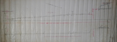
Plan - Casley's Red White and Blue Mine
... spring gully...Burns Street...reservoir...Casley's Red White and Blue Gold Mine was located between Burns Street and the Spring Gully Reservoir, Spring Gully. SHEEPSHEAD REEF, DIAMOND HILL, BENDIGO Location BURNS STREET SPRING GULLY, GREATER BENDIGO CITY Municipality GREATER BENDIGO CITY Level of significance Heritage Inventory Site Heritage Inventory (HI) Number H7724-0212 (Heritage Victoria database: chrome-extension://efaidnbmnnnibpcajpcglclefindmkaj/https://vhd.heritagecouncil.vic.gov.au/places/8513/download-report Bendigo Advertiser, 27 February, 1914: '...the Government made a special grant of £1000 to the Company on conditions that the shaft was sunk 200 ft from the present lowest level of 893ft'...Casley's Red White and Blue Gold Mine was located between Burns Street and the Spring Gully Reservoir, Spring Gully. SHEEPSHEAD REEF, DIAMOND HILL, BENDIGO Location BURNS STREET SPRING GULLY, GREATER BENDIGO CITY Municipality GREATER BENDIGO CITY Level of significance Heritage Inventory Site Heritage Inventory (HI) Number H7724-0212 (Heritage Victoria database: chrome-extension://efaidnbmnnnibpcajpcglclefindmkaj/https://vhd.heritagecouncil.vic.gov.au/places/8513/download-report Bendigo Advertiser, 27 February, 1914: '...the Government made a special grant of £1000 to the Company on conditions that the shaft was sunk 200 ft from the present lowest level of 893ft' Bendigo Margaret Roberts gold Casley's red white and blue spring gully Burns Street reservoir Hand drawn cross section plan of Casley's Red White and Blue Mine. ...Casley's Red White and Blue Gold Mine was located between Burns Street and the Spring Gully Reservoir, Spring Gully. SHEEPSHEAD REEF, DIAMOND HILL, BENDIGO Location BURNS STREET SPRING GULLY, GREATER BENDIGO CITY Municipality GREATER BENDIGO CITY Level of significance Heritage Inventory Site Heritage Inventory (HI) Number H7724-0212 (Heritage Victoria database: chrome-extension://efaidnbmnnnibpcajpcglclefindmkaj/https://vhd.heritagecouncil.vic.gov.au/places/8513/download-report Bendigo Advertiser, 27 February, 1914: '...the Government made a special grant of £1000 to the Company on conditions that the shaft was sunk 200 ft from the present lowest level of 893ft'Hand drawn cross section plan of Casley's Red White and Blue Mine. Forms part of the Margaret Roberts Collection of mining memorabilia.bendigo, margaret roberts, gold, casley's red white and blue, spring gully, burns street, reservoir -
 Bendigo Historical Society Inc.
Map - SANDHURST (PART), No date Visible
... Map: Hand Draughted parish plan showing the area North and East of Spring Gully Reservoir ( number 206 in Map Cupboard 1)...History House 11 Mackenzie Street Bendigo goldfields MAP Bendigo parish plan Parish of Sandhurst Spring Gully Map: Hand Draughted parish plan showing the area North and East of Spring Gully Reservoir ( number 206 in Map Cupboard 1) Map SANDHURST (PART) ...Map: Hand Draughted parish plan showing the area North and East of Spring Gully Reservoir ( number 206 in Map Cupboard 1)map, bendigo, parish plan, parish of sandhurst, spring gully -
 Bendigo Historical Society Inc.
Plan - New Golden Fleece Mine
... The New Golden Fleece Gold Mine was located approx. one km west of the Spring Gully Reservoir, Spring Gully, nearby to the Altona Gold Mine. ...The New Golden Fleece Gold Mine was located approx. one km west of the Spring Gully Reservoir, Spring Gully, nearby to the Altona Gold Mine. gold mining gold Bendigo Golden Square transverse section Diamond Hill Diamond Hill Road New Golden Fleece Mine Transverse section New Golden Fleece Mine. ...The New Golden Fleece Gold Mine was located approx. one km west of the Spring Gully Reservoir, Spring Gully, nearby to the Altona Gold Mine. Transverse section New Golden Fleece Mine. Plan shows shaft and levels. The mine was located on Diamond Hill, near Diamond Hill Road: https://bendigo.gold/ Plan is signed by W.H. Cundy, 27.9.10. Plan forms part of the Margaret Roberts Collection.gold mining, gold, bendigo, golden square, transverse section, diamond hill, diamond hill road, new golden fleece mine -
Bendigo Historical Society Inc.
Plan - Victoria Proprietary Co
... Mine was located near Wattle Drive, Spring Gully, inside the Spring Gully Reservoir reserve....Mine was located near Wattle Drive, Spring Gully, inside the Spring Gully Reservoir reserve. gold mining gold Bendigo Victoria Pty Ltd. ...Victoria Pty Ltd. Mine was located near Wattle Drive, Spring Gully, inside the Spring Gully Reservoir reserve.Victoria Proprietary Company Plan forms part of the Margaret Roberts Collection.gold mining, gold, bendigo, victoria pty ltd., spring gully, wattle drive -
Bendigo Historical Society Inc.
Plan - Nell Gwynne Reef N.L
... The Nell Gwynne gold mine was located near the Spring Gully Reservoir, on the Burns Street side. It is now within the fenced boundary of the Reservoir....The Nell Gwynne gold mine was located near the Spring Gully Reservoir, on the Burns Street side. It is now within the fenced boundary of the Reservoir. gold mining gold Bendigo Nell Gwynne Reef Nell Gwynne Reef N.L. ...The Nell Gwynne gold mine was located near the Spring Gully Reservoir, on the Burns Street side. It is now within the fenced boundary of the Reservoir.Nell Gwynne Reef N.L. Plan forms part of the Margaret Roberts Collection.gold mining, gold, bendigo, nell gwynne reef -
 Bendigo Historical Society Inc.
Document - DEAD DOG GULLY DIAMOND HILL
... Spring Gully. History of the area is given from 1860 onwards. Reference to Spring Gully Reservoir and water availability for mining in the area....Spring Gully. History of the area is given from 1860 onwards. Reference to Spring Gully Reservoir and water availability for mining in the area. ...Description of the Dead Dog Gully (1.2) area on Diamond Hill, researched and described by David Bannear, two page document. Dead Dog Gully runs alongside Burns Road, Spring Gully. History of the area is given from 1860 onwards. Reference to Spring Gully Reservoir and water availability for mining in the area.bendigo, mining, dead dog gully -
 Bendigo Historical Society Inc.
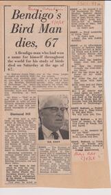
Newspaper - LYDIA CHANCELLOR COLLECTION: REDVERS EDDY OBITUARY
... Redvers lived near the Spring Gully Reservoir and taught chemistry at the School of Mines, Bendigo. ...Redvers lived near the Spring Gully Reservoir and taught chemistry at the School of Mines, Bendigo. ...Newspaper clipping (Bendigo Advertiser, 5th August 1968) on backing cardboard, telling story of Redvers James Eddy, an expert of wildlife and minerals. Redvers lived near the Spring Gully Reservoir and taught chemistry at the School of Mines, Bendigo. One of his 'better known works is a record of bird sounds, calls and songs'. Also attached alongside the article are his death and funeral notice.person, bendigo, redvers james eddy -
 Bendigo Historical Society Inc.
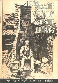
Document - PURDY COLLECTION: VALLEY OF THE SPRINGS
... Spring Gully's First 127 Years. Contains poem about Spring Gully by J.C. Hattam, Photos: St. Phillips Spring Gully, choir practice; garden party to raise funds for St. Phillips, taken on Keck's verandah, Abbotts Tannery, Tannery Lane, school photos, opening of tower on One Tree Hill, a mine at Diamond Hill (un-named) horse drawn vehicles, wood carter, Spring Gully reservoir being enlarged....spring gully Written on front in biro 'J.B. Purdy, 49 Bellevue Road, Golden Square. Booklet: 'The Valley of the Springs' a booklet produced to celebrate Spring Gully's First 127 Years. Contains poem about Spring Gully by J.C. Hattam, Photos: St. Phillips Spring Gully, choir practice; garden party to raise funds for St. Phillips, taken on Keck's verandah, Abbotts Tannery, Tannery Lane, school photos, opening of tower on One Tree Hill, a mine at Diamond Hill (un-named) horse drawn vehicles, wood carter, Spring Gully reservoir ...Booklet: 'The Valley of the Springs' a booklet produced to celebrate Spring Gully's First 127 Years. Contains poem about Spring Gully by J.C. Hattam, Photos: St. Phillips Spring Gully, choir practice; garden party to raise funds for St. Phillips, taken on Keck's verandah, Abbotts Tannery, Tannery Lane, school photos, opening of tower on One Tree Hill, a mine at Diamond Hill (un-named) horse drawn vehicles, wood carter, Spring Gully reservoir being enlarged. Written on front in biro 'J.B. Purdy, 49 Bellevue Road, Golden Square. bendigo, history, spring gully -
 Bendigo Historical Society Inc.
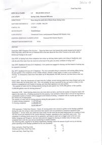
Document - Kangaroo Flat Gold Mine Collection: Diamond Hill Historic Area, Department of Conservation and Environment, April 1991
... Diamond Hill was a gold mining village 5 km south of Bendigo and about 1 km west of the Spring Gully Reservoir. Its location is now inaccessible and within the water catchment area. ...Diamond Hill was a gold mining village 5 km south of Bendigo and about 1 km west of the Spring Gully Reservoir. Its location is now inaccessible and within the water catchment area. ...Diamond Hill was a gold mining village 5 km south of Bendigo and about 1 km west of the Spring Gully Reservoir. Its location is now inaccessible and within the water catchment area. Diamond Hill was reputedly named after a diamond shaped rock on the hill. With the development of mining companies which employed workers with families, a school was needed by 1873 and one was opened at the beginning of the next year. The mining companies included Great Comet Quartz Mining, Golden Fleece Quartz Mining, Albert Tribute, Glasgow Golconda, and Albert Gold Mining and Crushing. Mining continued beyond 1900, as recorded in the Australian handbook, 1903. The Bendigo Mining N.L. company was located nearby, adjoining Ham Street. One page double sided information sheet, produced by Department of Conservation and Environment, April 1991, detailing the mining history of the Diamond Hill area, Kangaroo Flat/Spring Gully area. On the back of the sheet: map of the Diamond Hill historic area, showing location of former mining sites. bendigo mining n.l., bendigo, mining, gold, city of greater bendigo, great comet quartz mining, golden fleece quartz mining, albert tribute, glasgow golconda, albert gold mining and crushing, golden gully, dead dog gully, german miners, british new chum, south golden carshalton, hansel mundy, morning light, mullock tailings, stamp battery, -
 Bendigo Historical Society Inc.
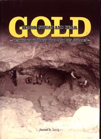
Book - "Gold. Blood, sweat and fear. Bendigo's Diamond Hill and its gullies", 2002
... Diamond Hill was a gold mining village 5 km south of Bendigo and about 1 km west of the Spring Gully Reservoir. Its location is now in the water catchment area. ...Diamond Hill was a gold mining village 5 km south of Bendigo and about 1 km west of the Spring Gully Reservoir. Its location is now in the water catchment area. ...Bendigo's Diamond Hill forms part of the southern part of Bendigo goldfields. Diamond Hill was a gold mining village 5 km south of Bendigo and about 1 km west of the Spring Gully Reservoir. Its location is now in the water catchment area. Diamond Hill was reputedly named after a diamond shaped rock on the hill. With the development of mining companies which employed workers with families, a school was needed by 1873 and one was opened at the beginning of the next year. The mining companies included Great Comet Quartz Mining, Golden Fleece Quartz Mining, Albert Tribute and Albert Gold Mining and Crushing. Mining continued beyond 1900. This book discusses history of the area from Dream Time to first European contact, focusing on the associated mining in the area. "Gold. Blood, Sweat and Fear. Bendigo's Diamond Hill and its gullies" by James A Lerk. Published in by JA and ERS Lerk. Published in 2016. Soft cover book. Front cover has sepia image of miners in mine. Back cover is black with assortment of handwritten documents/invoices. Title written in gold and dark brown. Title also on spine. Printed in Bendigo, Australia. 252 pp. Folded Bendigo map folded inside back cover. Contains both text and black and white images. Has index. gold, diamond hill, miners, mining -
 Bendigo Historical Society Inc.
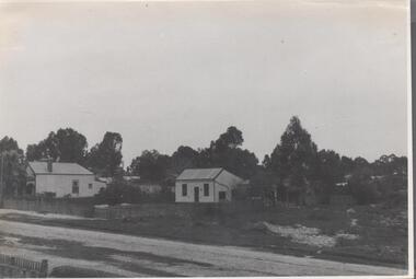
Photograph - Nell Gwynne Gold Mine site, 1934
... The Nell Gwynne mine site was within the Spring Gully Water Reserve, north west of the reservoir near Diamond Hill Road. ...History House 11 Mackenzie Street Bendigo goldfields The Nell Gwynne mine site was within the Spring Gully Water Reserve, north west of the reservoir near Diamond Hill Road. ...The Nell Gwynne mine site was within the Spring Gully Water Reserve, north west of the reservoir near Diamond Hill Road. An abridged prospectus for the Nell Gwynne (B.M.L.) No Liability, was published in the Sun News Pictorial on 7th June 1934, page 26 (Advertising).https://trove.nla.gov.au/newspaper/article/277316940?searchTerm=napoleon%20bmlSignificant to mining history of Bendigo.Black and white photograph of two weatherboard houses in bush setting. Gravel road in foreground. Written in pencil on back of photograph in pencil: 'Nell Gwynne 25.9.34'nell gwynne gold mine -
 Bendigo Historical Society Inc.
Photograph - Historical Society Field Trip to the Springs at Sedgwick, Abt 2009
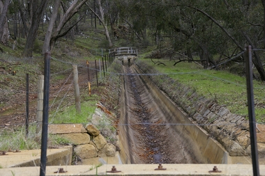
... Springs" on the main Coliban water channel from Malmsbury to the Sandhurst Reservoir in Bendigo. The water race descends through a concrete chute, and continues sharply around the contour of the hills. Once it descended into a syphon across the gully...Springs" on the main Coliban water channel from Malmsbury to the Sandhurst Reservoir in Bendigo. The water race descends through a concrete chute, and continues sharply around the contour of the hills. Once it descended into a syphon across the gully ...The Phil Wilkin Collection contains a series of 11 Items. The related items can be found by clicking on the reference link below. The following history of the Young family and their descendants who lived at the Springs is provided by Phil Wilkin. His Great Grandparents were Frances Young and August Wirth. Phil has also provided notes on the Wilkin Family and some history of the gold mining in Sedgwick. Frances Young's parents Joseph and Margaret Young owned the property called "The Old Place, Preston Vale or Wellington Flat" at Sedgwick near the Springs. Joseph Young owned and Managed the Standard Brewery which was located at Campbells Creek during the late 1800’s early 1900’s. Joseph and Margaret are buried in the Harcourt cemetery. In 1880 August Wirth lived at Mosquito Creek (Lake Eppalock, Victoria) when he married Frances Young. In 1902 they moved to part of Joseph Young's property. They milked cows and sold cattle for a living. One of their children Charles Wirth (Phil Wilkin's Grandfather) bought the land in 1935 after his parents had died. Charles Wirth was a councillor and also was president of the Shire of Strathfieldsaye. The "Old Place" was part of the property owned by members of the family. The old house at the Springs was burnt out by bushfire in January 1944 and much of the stonework was later vandalized by campers. The original Coliban Water Works were designed in 1863 by the Irish engineer Joseph Brady. The system included 70 kilometres of open water channels, aqueducts, syphons and tunnels to carry water (by gravity) from the Coliban River at Malmsbury, north to Castlemaine and Bendigo. Sedgwick is a locality in Central Victoria, Australia. It is located in the City of Greater Bendigo. Facilities include a public hall that opened in 1958 and CFA Rural fire station. It was named Upper Emu Creek until 1901 when it was renamed as Sedgwick after British geologist Adam Sedgwick.Twenty nine photos taken on a field trip by the Bendigo Historical Society to "The Springs" on the main Coliban water channel from Malmsbury to the Sandhurst Reservoir in Bendigo. The water race descends through a concrete chute, and continues sharply around the contour of the hills. Once it descended into a syphon across the gully. The are 182 photos in this series and can be found at 8683.1 to 8683.11. The series also includes photos of the surrounding farming land and the remains of an old house. There are also some notes on the pioneers of the district.history, bendigo, coliban water, joseph brady, irrigation, the springs, sedgwick -
 Bendigo Historical Society Inc.
Photograph - Historical Society Field Trip to the Springs at Sedgwick, Abt 2009
... Springs" on the main Coliban water channel from Malmsbury to the Sandhurst Reservoir in Bendigo. The water race descends through a concrete chute, and continues sharply around the contour of the hills. Once it descended into a syphon across the gully...Springs" on the main Coliban water channel from Malmsbury to the Sandhurst Reservoir in Bendigo. The water race descends through a concrete chute, and continues sharply around the contour of the hills. Once it descended into a syphon across the gully ...The Phil Wilkin Collection contains a series of 11 Items. The related items can be found by clicking on the reference link below. The following history of the Young family and their descendants who lived at the Springs is provided by Phil Wilkin. His Great Grandparents were Frances Young and August Wirth. Phil has also provided notes on the Wilkin Family and some history of the gold mining in Sedgwick. Frances Young's parents Joseph and Margaret Young owned the property called "The Old Place, Preston Vale or Wellington Flat" at Sedgwick near the Springs. Joseph Young owned and Managed the Standard Brewery which was located at Campbells Creek during the late 1800’s early 1900’s. Joseph and Margaret are buried in the Harcourt cemetery. In 1880 August Wirth lived at Mosquito Creek (Lake Eppalock, Victoria) when he married Frances Young. In 1902 they moved to part of Joseph Young's property. They milked cows and sold cattle for a living. One of their children Charles Wirth (Phil Wilkin's Grandfather) bought the land in 1935 after his parents had died. Charles Wirth was a councillor and also was president of the Shire of Strathfieldsaye. The "Old Place" was part of the property owned by members of the family. The old house at the Springs was burnt out by bushfire in January 1944 and much of the stonework was later vandalized by campers. The original Coliban Water Works were designed in 1863 by the Irish engineer Joseph Brady. The system included 70 kilometres of open water channels, aqueducts, syphons and tunnels to carry water (by gravity) from the Coliban River at Malmsbury, north to Castlemaine and Bendigo. Sedgwick is a locality in Central Victoria, Australia. It is located in the City of Greater Bendigo. Facilities include a public hall that opened in 1958 and CFA Rural fire station. It was named Upper Emu Creek until 1901 when it was renamed as Sedgwick after British geologist Adam Sedgwick.Twenty five photos taken on a field trip by the Bendigo Historical Society to "The Springs" on the main Coliban water channel from Malmsbury to the Sandhurst Reservoir in Bendigo. The water race descends through a concrete chute, and continues sharply around the contour of the hills. Once it descended into a syphon across the gully. The are 182 photos in this series and can be found at 8683.1 to 8683.11. The series also includes photos of the surrounding farming land and the remains of an old house. There are also some notes on the pioneers of the district.history, bendigo, coliban water, joseph brady, irrigation, the springs, sedgwick -
 Bendigo Historical Society Inc.
Photograph - Historical Society Field Trip to the Springs at Sedgwick, Abt 2009
... Springs" on the main Coliban water channel from Malmsbury to the Sandhurst Reservoir in Bendigo. The water race descends through a concrete chute, and continues sharply around the contour of the hills. Once it descended into a syphon across the gully...Springs" on the main Coliban water channel from Malmsbury to the Sandhurst Reservoir in Bendigo. The water race descends through a concrete chute, and continues sharply around the contour of the hills. Once it descended into a syphon across the gully ...The Phil Wilkin Collection contains a series of 11 Items. The related items can be found by clicking on the reference link below. The following history of the Young family and their descendants who lived at the Springs is provided by Phil Wilkin. His Great Grandparents were Frances Young and August Wirth. Phil has also provided notes on the Wilkin Family and some history of the gold mining in Sedgwick. Frances Young's parents Joseph and Margaret Young owned the property called "The Old Place, Preston Vale or Wellington Flat" at Sedgwick near the Springs. Joseph Young owned and Managed the Standard Brewery which was located at Campbells Creek during the late 1800’s early 1900’s. Joseph and Margaret are buried in the Harcourt cemetery. In 1880 August Wirth lived at Mosquito Creek (Lake Eppalock, Victoria) when he married Frances Young. In 1902 they moved to part of Joseph Young's property. They milked cows and sold cattle for a living. One of their children Charles Wirth (Phil Wilkin's Grandfather) bought the land in 1935 after his parents had died. Charles Wirth was a councillor and also was president of the Shire of Strathfieldsaye. The "Old Place" was part of the property owned by members of the family. The old house at the Springs was burnt out by bushfire in January 1944 and much of the stonework was later vandalized by campers. The original Coliban Water Works were designed in 1863 by the Irish engineer Joseph Brady. The system included 70 kilometres of open water channels, aqueducts, syphons and tunnels to carry water (by gravity) from the Coliban River at Malmsbury, north to Castlemaine and Bendigo. Sedgwick is a locality in Central Victoria, Australia. It is located in the City of Greater Bendigo. Facilities include a public hall that opened in 1958 and CFA Rural fire station. It was named Upper Emu Creek until 1901 when it was renamed as Sedgwick after British geologist Adam Sedgwick.Twenty six photos taken on a field trip by the Bendigo Historical Society to "The Springs" on the main Coliban water channel from Malmsbury to the Sandhurst Reservoir in Bendigo. The water race descends through a concrete chute, and continues sharply around the contour of the hills. Once it descended into a syphon across the gully. The are 182 photos in this series and can be found at 8683.1 to 8683.11. The series also includes photos of the surrounding farming land and the remains of an old house. There are also some notes on the pioneers of the district.history, bendigo, coliban water, joseph brady, irrigation, the springs, sedgwick -
 Bendigo Historical Society Inc.
Photograph - Historical Society Field Trip to the Springs at Sedgwick, Abt 2009
... Springs" on the main Coliban water channel from Malmsbury to the Sandhurst Reservoir in Bendigo. The water race descends through a concrete chute, and continues sharply around the contour of the hills. Once it descended into a syphon across the gully...Springs" on the main Coliban water channel from Malmsbury to the Sandhurst Reservoir in Bendigo. The water race descends through a concrete chute, and continues sharply around the contour of the hills. Once it descended into a syphon across the gully ...The Phil Wilkin Collection contains a series of 11 Items. The related items can be found by clicking on the reference link below. The following history of the Young family and their descendants who lived at the Springs is provided by Phil Wilkin. His Great Grandparents were Frances Young and August Wirth. Phil has also provided notes on the Wilkin Family and some history of the gold mining in Sedgwick. Frances Young's parents Joseph and Margaret Young owned the property called "The Old Place, Preston Vale or Wellington Flat" at Sedgwick near the Springs. Joseph Young owned and Managed the Standard Brewery which was located at Campbells Creek during the late 1800’s early 1900’s. Joseph and Margaret are buried in the Harcourt cemetery. In 1880 August Wirth lived at Mosquito Creek (Lake Eppalock, Victoria) when he married Frances Young. In 1902 they moved to part of Joseph Young's property. They milked cows and sold cattle for a living. One of their children Charles Wirth (Phil Wilkin's Grandfather) bought the land in 1935 after his parents had died. Charles Wirth was a councillor and also was president of the Shire of Strathfieldsaye. The "Old Place" was part of the property owned by members of the family. The old house at the Springs was burnt out by bushfire in January 1944 and much of the stonework was later vandalized by campers. The original Coliban Water Works were designed in 1863 by the Irish engineer Joseph Brady. The system included 70 kilometres of open water channels, aqueducts, syphons and tunnels to carry water (by gravity) from the Coliban River at Malmsbury, north to Castlemaine and Bendigo. Sedgwick is a locality in Central Victoria, Australia. It is located in the City of Greater Bendigo. Facilities include a public hall that opened in 1958 and CFA Rural fire station. It was named Upper Emu Creek until 1901 when it was renamed as Sedgwick after British geologist Adam Sedgwick.Twenty five photos taken on a field trip by the Bendigo Historical Society to "The Springs" on the main Coliban water channel from Malmsbury to the Sandhurst Reservoir in Bendigo. The water race descends through a concrete chute, and continues sharply around the contour of the hills. Once it descended into a syphon across the gully. The are 182 photos in this series and can be found at 8683.1 to 8683.11. The series also includes photos of the surrounding farming land and the remains of an old house. There are also some notes on the pioneers of the district.history, bendigo, coliban water, joseph brady, irrigation, the springs, sedgwick -
 Bendigo Historical Society Inc.
Photograph - The Young and Wirth Families at Preston Vale, near the Springs Sedgwick, 1880s-1900s
... Springs" on the main Coliban water channel from Malmsbury to the Sandhurst Reservoir in Bendigo. This item contains family history of Joeph's descendant Charles Wirth, who was a councillor for the Shire of Strathfieldsaye. The water race descends through a concrete chute, and continues sharply around the contour of the hills. Once it descended into a syphon across the gully...Springs" on the main Coliban water channel from Malmsbury to the Sandhurst Reservoir in Bendigo. This item contains family history of Joeph's descendant Charles Wirth, who was a councillor for the Shire of Strathfieldsaye. The water race descends through a concrete chute, and continues sharply around the contour of the hills. Once it descended into a syphon across the gully ...The Phil Wilkin Collection contains a series of 11 Items. The related items can be found by clicking on the reference link below. The following history of the Young family and their descendants who lived at the Springs is provided by Phil Wilkin. His Great Grandparents were Frances Young and August Wirth. Phil has also provided notes on the Wilkin Family and some history of the gold mining in Sedgwick. Frances Young's parents Joseph and Margaret Young owned the property called "The Old Place, Preston Vale or Wellington Flat" at Sedgwick near the Springs. Joseph Young owned and Managed the Standard Brewery which was located at Campbells Creek during the late 1800’s early 1900’s. Joseph and Margaret are buried in the Harcourt cemetery. In 1880 August Wirth lived at Mosquito Creek (Lake Eppalock, Victoria) when he married Frances Young. In 1902 they moved to part of Joseph Young's property. They milked cows and sold cattle for a living. One of their children Charles Wirth (Phil Wilkin's Grandfather) bought the land in 1935 after his parents had died. Charles Wirth was a councillor and also was president of the Shire of Strathfieldsaye. The "Old Place" was part of the property owned by members of the family. The old house at the Springs was burnt out by bushfire in January 1944 and much of the stonework was later vandalized by campers. The original Coliban Water Works were designed in 1863 by the Irish engineer Joseph Brady. The system included 70 kilometres of open water channels, aqueducts, syphons and tunnels to carry water (by gravity) from the Coliban River at Malmsbury, north to Castlemaine and Bendigo. Sedgwick is a locality in Central Victoria, Australia. It is located in the City of Greater Bendigo. Facilities include a public hall that opened in 1958 and CFA Rural fire station. It was named Upper Emu Creek until 1901 when it was renamed as Sedgwick after British geologist Adam Sedgwick.Thirty Four Photos of Joseph Young's property near "The Springs" on the main Coliban water channel from Malmsbury to the Sandhurst Reservoir in Bendigo. This item contains family history of Joeph's descendant Charles Wirth, who was a councillor for the Shire of Strathfieldsaye. The water race descends through a concrete chute, and continues sharply around the contour of the hills. Once it descended into a syphon across the gully. The are 182 photos in this series and can be found at 8683.1 to 8683.11. The series also includes photos of the surrounding farming land and the remains of an old house. There are also some notes on the pioneers of the district.history, bendigo, coliban water, joseph brady, irrigation, the springs, sedgwick, charles wirth, preston vale, joseph and margaret young, standard brewery campbells creek harcourt, phil wilkin collection -
 Bendigo Historical Society Inc.
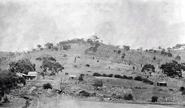
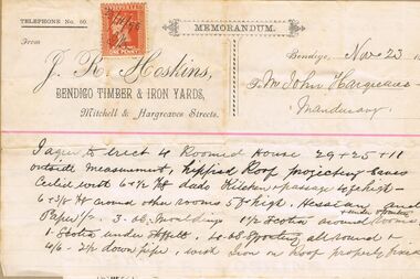
Document - LUDERMAN COLLECTION: SPRING GULLY, MANDURANG DOCUMENTS
... Hoskin, Bendigo Timber and Iron Yards relating to construction of residence in Spring Gully (1896); Certificate of Registration of Residence Area for Thomas Snowdon, adjoining Hargreaves residence 200 yards from Reservoir; Elector's Right for John Billman Hargreaves of Mandurang, Tanner; handwritten note (Bairnsdale 24.1.34) on John Billman Hargreaves born 1861 on 14 June on Sheepwash Creek in Mandurang riding Shire of Strathfieldsaye near Bendigo possibly registered at Strathfieldsaye, Kangaroo Flat or Bendigo. ...Hoskin, Bendigo Timber and Iron Yards relating to construction of residence in Spring Gully (1896); Certificate of Registration of Residence Area for Thomas Snowdon, adjoining Hargreaves residence 200 yards from Reservoir; Elector's Right for John Billman Hargreaves of Mandurang, Tanner; handwritten note (Bairnsdale 24.1.34) on John Billman Hargreaves born 1861 on 14 June on Sheepwash Creek in Mandurang riding Shire of Strathfieldsaye near Bendigo possibly registered at Strathfieldsaye, Kangaroo Flat or Bendigo. ...Document. Pastel Drawing Book, 'Bulldog' Series No. 589, containing series of invoices and documents relating to the Hargreaves family. Items stuck in book in order includes: invoices from J.R. Hoskin, Bendigo Timber and Iron Yards relating to construction of residence in Spring Gully (1896); Certificate of Registration of Residence Area for Thomas Snowdon, adjoining Hargreaves residence 200 yards from Reservoir; Elector's Right for John Billman Hargreaves of Mandurang, Tanner; handwritten note (Bairnsdale 24.1.34) on John Billman Hargreaves born 1861 on 14 June on Sheepwash Creek in Mandurang riding Shire of Strathfieldsaye near Bendigo possibly registered at Strathfieldsaye, Kangaroo Flat or Bendigo. Father's name John Hargreaves (English) mother's name Hosannah Hargreaves nee Billman'; 2 scrip certificates issued by 'Tanners Gold Mining Compagnie Pipers Hill, Sheepwash' overwritten on top of document ( underneath North Lord Warden Tribute Co., ) scrip certificate issued to John B. Hargreaves on 25 September 1882; invoice Jas. Knowlton, late J. Moody, watchmaker and jeweller, No. 1 Bath Corner, Bendigo 3.8.1895 for Diamond brooch; invoice H. Credginton watchmaker and jeweller and optician for 1 gem ring. Loose document inside contains written advice re taking wool off sheep skins and curing hides.person, individual, hargreaves, hoskins, hargreaves, snowdon, elector's right, tanner's gold mining compagnie, north lord warden tribute co., knowlton, credgington