Showing 38 items matching " state foundations"
-
 Musculoskeletal Health Australia (now held by the Glen Eira Historical Society)
Photograph - Group photo, XX/05/2005
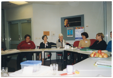
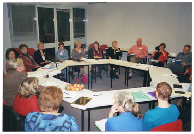
... ... state foundations...In May 2005, a State Foundations Educators' Meeting was held at the Arthritis Foundation of Victoria's headquarters in Elsternwick. ...[On a white label, typed in black ink] State Foundations - Educators Meeting May 2005...This photo depicts several attendees seated at tables during the meeting. arthritis foundation of victoria afv osteoporosis victoria ov state foundations educators meeting 2005 [On a white label, typed in black ink] State Foundations - Educators Meeting May 2005 COL photo of a group of people seated at tables set in a circle formation. ...In May 2005, a State Foundations Educators' Meeting was held at the Arthritis Foundation of Victoria's headquarters in Elsternwick. This photo depicts several attendees seated at tables during the meeting.COL photo of a group of people seated at tables set in a circle formation. There are various items on the tables, such as folders and diaries, a lunchbox and several glasses, and a platter of apples. In the background, there is a telephone affixed to the wall, and a display board. There are several posters pinned to the display board, with headings such as "Active Living: get stronger with age", "National Healthy Bones Week", and "10 Steps for Living Well". Further along the wall, there is a set of closed double glass doors.[On a white label, typed in black ink] State Foundations - Educators Meeting May 2005arthritis foundation of victoria, afv, osteoporosis victoria, ov, state foundations, educators, meeting, 2005 -
 Musculoskeletal Health Australia (now held by the Glen Eira Historical Society)
Photograph - Group photo, XX/05/2005
... ... state foundations...In May 2005, a State Foundations Educators' Meeting was held at the Arthritis Foundation of Victoria's headquarters in Elsternwick. ...[On a white label, typed in black ink] State Foundations - Educators Meeting May 2005...This photo depicts several attendees seated at tables during the meeting. arthritis foundation of victoria afv osteoporosis victoria ov state foundations educators meeting 2005 [On a white label, typed in black ink] State Foundations - Educators Meeting May 2005 COL photo of a group of people seated at tables set in a circle formation. ...In May 2005, a State Foundations Educators' Meeting was held at the Arthritis Foundation of Victoria's headquarters in Elsternwick. This photo depicts several attendees seated at tables during the meeting.COL photo of a group of people seated at tables set in a circle formation. There are various items on the tables, such as a small brass bell, folders, diaries and note books, a lunchbox and glasses, and a platter of apples. In the background, there is a telephone affixed to the wall next to a display board. There are posters pinned to the display board, with headings such as "Active Living Age is no barrier to good health" and "The Pyramid of Good Health". In the centre-left of the frame, there is a set of large bi-fold doors folded back in the open position. To the right of the frame, there is a large whiteboard affixed to a perpendicular wall.[On a white label, typed in black ink] State Foundations - Educators Meeting May 2005arthritis foundation of victoria, afv, osteoporosis victoria, ov, state foundations, educators, meeting, 2005 -
 Musculoskeletal Health Australia (now held by the Glen Eira Historical Society)
Photograph - Group photo, XX/05/2005
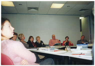
... ... state foundations...In May 2005, a State Foundations Educators' Meeting was held at the Arthritis Foundation of Victoria's headquarters in Elsternwick. ...[On a white label, typed in black ink] State Foundations - Educators Meeting May 2005...This photo depicts several attendees seated at tables during the meeting. arthritis foundation of victoria afv osteoporosis victoria ov state foundations educators meeting 2005 [On a white label, typed in black ink] State Foundations - Educators Meeting May 2005 COL photo of a group of people seated at tables set in a circle formation. ...In May 2005, a State Foundations Educators' Meeting was held at the Arthritis Foundation of Victoria's headquarters in Elsternwick. This photo depicts several attendees seated at tables during the meeting.COL photo of a group of people seated at tables set in a circle formation. There are various items on the tables, such as a small brass bell, folders, diaries and note books, a pencil, a glass, and a lunchbox. In the background, there is a set of large bi-fold doors held in the closed position, with the last panel opening out into the room behind.[On a white label, typed in black ink] State Foundations - Educators Meeting May 2005arthritis foundation of victoria, afv, osteoporosis victoria, ov, state foundations, educators, meeting, 2005 -
 Musculoskeletal Health Australia (now held by the Glen Eira Historical Society)
Photograph - Group photo, XX/05/2005
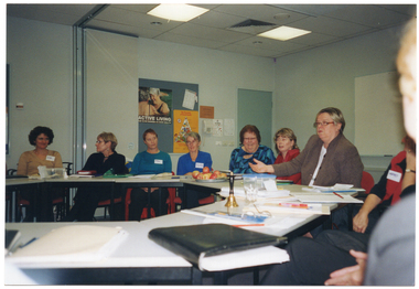
... ... state foundations...In May 2005, a State Foundations Educators' Meeting was held at the Arthritis Foundation of Victoria's headquarters in Elsternwick. ...[On a white label, typed in black ink] State Foundations - Educators Meeting May 2005...This photo depicts most of the attendees seated at tables during the meeting. arthritis foundation of victoria afv osteoporosis victoria ov state foundations educators meeting 2005 [On a white label, typed in black ink] State Foundations - Educators Meeting May 2005 COL photo of a group of people seated at tables set in a circle formation. ...In May 2005, a State Foundations Educators' Meeting was held at the Arthritis Foundation of Victoria's headquarters in Elsternwick. This photo depicts most of the attendees seated at tables during the meeting.COL photo of a group of people seated at tables set in a circle formation. There are various items on the tables, such as a small brass bell, folders, diaries, note books, leaflets, pens and pencils, a glass, a lunchbox, and a platter of apples. In the background are two display boards affixed to the wall, with posters pinned on the boards. The posters on one board contain headings such as "Active Living: get stronger with age", "National Healthy Bones Week", and "10 Steps for Living Well". The posters on the other board contain headings such as "Active Living Age is no barrier to good health", and "The Pyramid of Good Health". In the centre-left of the frame, there is a set of large bi-fold doors folded back in the open position. Further along the wall, there is a closed door. To the right of the frame, there is a large whiteboard affixed to a perpendicular wall.[On a white label, typed in black ink] State Foundations - Educators Meeting May 2005arthritis foundation of victoria, afv, osteoporosis victoria, ov, state foundations, educators, meeting, 2005 -
 Musculoskeletal Health Australia (now held by the Glen Eira Historical Society)
Photograph - Group photo, XX/05/2005
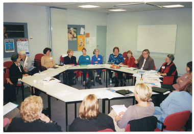
... ... state foundations...In May 2005, a State Foundations Educators' Meeting was held at the Arthritis Foundation of Victoria's headquarters in Elsternwick. ...[On a white label, typed in black ink] State Foundations - Educators Meeting May 2005...This photo depicts most of the attendees seated at tables during the meeting. arthritis foundation of victoria afv osteoporosis victoria ov state foundations educators meeting 2005 [On a white label, typed in black ink] State Foundations - Educators Meeting May 2005 COL photo of a group of people seated at tables set in a circle formation. ...In May 2005, a State Foundations Educators' Meeting was held at the Arthritis Foundation of Victoria's headquarters in Elsternwick. This photo depicts most of the attendees seated at tables during the meeting.COL photo of a group of people seated at tables set in a circle formation. There are various items on the tables, such as a small brass bell, folders, diaries, note books, leaflets, pens and pencils, a lunchbox, and a platter of apples. In the background, there is a set of double glass doors with a large window on either side. The windows have venetian blinds attached.[On a white label, typed in black ink] State Foundations - Educators Meeting May 2005arthritis foundation of victoria, afv, osteoporosis victoria, ov, state foundations, educators, meeting, 2005 -
 Clunes Museum
Photograph
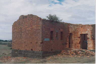
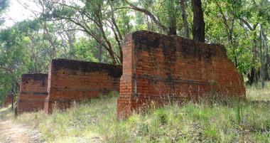
... COLOUR PHOTOGRAPH OF A BRICK BUILDING WITH BLUESTONE FOUNDATIONS - IN STATE OF DISREPAIR. ROOF DOORS & WINDOWS MISSING, SMALL PILE OF BRICK RUBBLE AT FRONT DOOR - BUILDING COULD BE REMAINS OF POWDER MAGAZINE NEAR BIRCH'S CREEK. ...Clunes Museum 36 Fraser Street enter building through Collins Place Clunes goldfields local history photography photographs mining powder magazine COLOUR PHOTOGRAPH OF A BRICK BUILDING WITH BLUESTONE FOUNDATIONS - IN STATE OF DISREPAIR. ROOF DOORS & WINDOWS MISSING, SMALL PILE OF BRICK RUBBLE AT FRONT DOOR - BUILDING COULD BE REMAINS OF POWDER MAGAZINE NEAR BIRCH'S CREEK. ...COLOUR PHOTOGRAPH OF A BRICK BUILDING WITH BLUESTONE FOUNDATIONS - IN STATE OF DISREPAIR. ROOF DOORS & WINDOWS MISSING, SMALL PILE OF BRICK RUBBLE AT FRONT DOOR - BUILDING COULD BE REMAINS OF POWDER MAGAZINE NEAR BIRCH'S CREEK. BOXTHORN GROWING IN GUTTERING.local history, photography, photographs, mining, powder magazine -
 Warrnambool and District Historical Society Inc.
Book, Silent Lives: Women of Warrnambool & district 1840-1910, November 2017
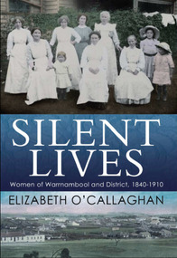
... State Library of Victoria. By their unremitting labours and self-sacrifice the pioneering women of Warrnambool and district helped to lay the foundations of our communities today....State Library of Victoria. By their unremitting labours and self-sacrifice the pioneering women of Warrnambool and district helped to lay the foundations of our communities today. ...A history documenting the lives of women in Warrnambool and district between 1840 and 1910.A4 size book with photograph of 7 women and 3 children in c1890sworking clothing and long white aprons, sitting and standing in front of a hedge with washing draped over the hedge. The two girls on the right are wearing wide-brimmed hats. The title is in white print on a band of dark blue across the middle. The bottom third features an early image of Warrnambool and the author's name in dark blue.non-fictionA history documenting the lives of women in Warrnambool and district between 1840 and 1910.warrnambool, history of warrnambool, 19th century women, women pioneers, silent lives, elizabeth o'callaghan, cover design james colquhoun -
 Kiewa Valley Historical Society
Photo - Foundations of Clover Power Station
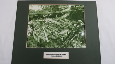
... State Electricity Commission of Victoria as part of the Kiewa Hydro Electric Scheme. Clover Power Station is situated near the Bogong Township and was the first power station in the KHES to be constructed. clover power station kiewa hydro electric scheme Green filtered photo with title ( black on white) underneath framed with green cardboard. Photo - Foundations ...Clover Power Station was being constructed on 9th June 1942 by the State Electricity Commission of Victoria as part of the Kiewa Hydro Electric Scheme.Clover Power Station is situated near the Bogong Township and was the first power station in the KHES to be constructed.Green filtered photo with title ( black on white) underneath framed with green cardboard.clover power station, kiewa hydro electric scheme -
 Kiewa Valley Historical Society
Photograph of Clover Power Station, No. 3 Power Station, after May 1944
... foundations and transfer track were completed in April, 1943 and the power station building in May, 1943. Installation of the machines was then proceeded with and No. 1 machine was run for the first time in June 1944. No. 2 machine was completed in April, 1944 and placed in service in May. A pictorial record for the State ...In July, 1941 work commenced on the site of the power station with the building of a coffer dam and excavation for the power station building and machine foundations followed. Work proceeded, and the access bridge, transformer foundations and transfer track were completed in April, 1943 and the power station building in May, 1943. Installation of the machines was then proceeded with and No. 1 machine was run for the first time in June 1944. No. 2 machine was completed in April, 1944 and placed in service in May.A pictorial record for the State Electricity Commission of the first Power Station commissioned in the Kiewa Hydro Electric Scheme.Black and white photograph of the bridge and entrance to No. 3 Power Station (Clover Power Station).Handwritten on back of photograph in blue ink "No. 3 Power Station".clover, power station, machine, kiewa scheme -
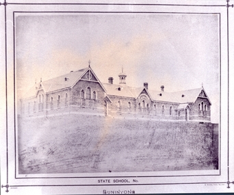 Federation University Historical Collection
Photograph - Photograph - black and white, Buninyong State School, c1974
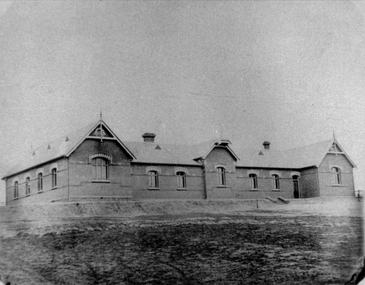
... It cost 2987 pounds education school Buninyong State School Buninyong Primary School Photograph of a brick building with bluestone foundations known as Buninyong Primary School. ...Buninyong State School was established in 1873, and opened on 28 August 1874 as a brick school to accommodate 500 pupils. It cost 2987 poundsPhotograph of a brick building with bluestone foundations known as Buninyong Primary School. It is Gothic in an oblong form and has grey bricks details from Lal Lal. education, school, buninyong state school, buninyong primary school -
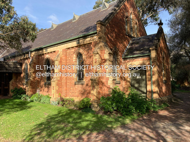 Eltham District Historical Society Inc
Photograph, Jim Connor, Eltham - Montmorency Uniting Church, 810 Main Rd, Eltham, 10 July 2023
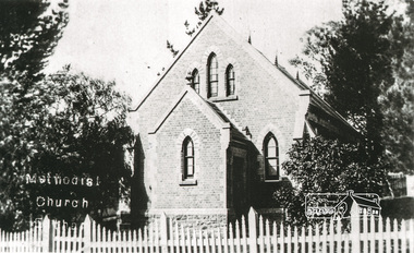
... Church member George Stebbing built the church, the foundations were constructed with stone from the walls of the first Eltham State Primary School (No. 209) building which collapsed in 1874 and were purchased by Robert David Taylor. ...Church member George Stebbing built the church, the foundations were constructed with stone from the walls of the first Eltham State Primary School (No. 209) building which collapsed in 1874 and were purchased by Robert David Taylor. ...Located on the corner of Main Road and John Street, the church first served the community as the Eltham Wesleyan Church since 1881. It became the Eltham Methodist Church in 1902, the year it united with the Primitive Methodists. Eltham Wesleyans first worshipped together in the home of William and Mary Crozier, on 24 acres bounded by Mount Pleasant Road and Pitt Street. From there they moved to a slab and bark hut in 1855 (this later served as the first school run by David Clark prior to the building of a new school in Dalton Street) and the members then built a chapel in 1858 on Lot 20, Henry Street (later to become the Rechabite Hall and Eltham Public Hall). The present church on John Street was designed by architects Crouch and Wilson in the Early English Gothic style with biochrome brick window frames, buttress heads and pinnacle. Church member George Stebbing built the church, the foundations were constructed with stone from the walls of the first Eltham State Primary School (No. 209) building which collapsed in 1874 and were purchased by Robert David Taylor. Stebbing was also responsible for building St Margaret’s Church and Shillinglaw Cottage. The Roll of Honour, which presently hangs in the church hall (which also doubles as the Opportunity Shop) lists 27 members of the congregation who served in the First World War, 11 of whom never returned. The red-brick Church Hall was opened in 1931 and in 1971 further additions linked the hall and church, including a foyer, vestry, meeting room and toilets reflecting the Eltham style of that time with its simplicity, extensive clear glass, reused baked clay-bricks from the 1881 church, heavy ceiling beams and compressed straw ceiling. On June 26, 1977, the church became part of the new Uniting Church in Australia consisting of the former Methodist and Congregational and most of the Presbyterian Churches. Following of declining numbers of worshippers, the church merged with the Montmorency Uniting Church on June 23, 1996. In 2023 the Uniting church approved a plan to renovate the church. It is understood that the historic church and the hall will be retained, and the building added in 1971 is to be demolished, to make way for a new purpose-built Opportunity shop. The proposed areas to be demolished include the current foyer, toilets, crèche, etc, including the area between the hall and the former RSL. Works are expected to commence mid to late July 2023. The Society was invited by a church member to take photographs of these areas to document them prior to demolition works commencing. Ref: “Nillumbik Now and Then” by Marguerite Marshall (2008)jim connor collection, 2023-07-10, eltham-montmorency uniting church, john street, methodist church, opportunity shop, uniting church, uniting church hall -
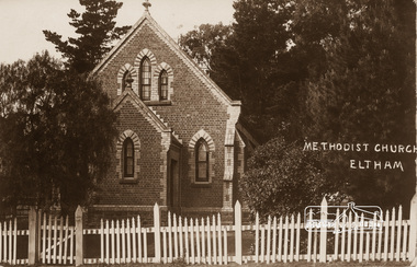 Eltham District Historical Society Inc
Photograph, Eltham Methodist Church, 1909, 1909
... Formerly Wesleyan, Methodist then Uniting church; the foundations of the church building were constructed with stone from the walls of the first Eltham State Primary School (No. 209) building which collapsed in 1874 and were purchased by Robert David Taylor. ...Formerly Wesleyan, Methodist then Uniting church; the foundations of the church building were constructed with stone from the walls of the first Eltham State Primary School (No. 209) building which collapsed in 1874 and were purchased by Robert David Taylor. ...Situated at 810 Main Road on the corner of John Street. The Church was surrounded by a picket fence and tall pine trees. The Church was built by George Stebbings in the 1850s and is an example of fine craftmanship. Formerly Wesleyan, Methodist then Uniting church; the foundations of the church building were constructed with stone from the walls of the first Eltham State Primary School (No. 209) building which collapsed in 1874 and were purchased by Robert David Taylor. REVISED STATEMENT OF SIGNIFICANCE, CONTEXT, 2010 via Victorian Heritage Database What is significant? The 1880 bichromatic brick church and the surrounding site to the title boundaries. How is it significant? The church is architecturally, historically, socially and spiritually significant to the Shire of Nillumbik. Why is it significant? The church is architecturally significant as a finely detailed example of a brick 19th century rural community church, one of only four in the Shire (Criteria E & B). The church is historically significant as an important link with the time when Eltham was a small, insular country settlement. Also for the historical evolution visible in the complex, with the modest 1880s church and larger red brick rear hall from the early 20th century as a reflection of population growth in the area (Criterion A). The church is historically, spiritually and socially significant because it has played, and continues to play, an important part in the spiritual and social life of the community (Criterion G).Sepia postcard of Eltham Methodist Church, 1909eltham, methodist church, church, state school no. 209, eltham state school, robert david taylor, eltham uniting church, uniting church, wesleyan church -
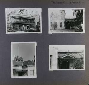 Glen Eira Historical Society
Album - Album page, Heatherbrae, 73 Neerim Road, Circa 1972
... state and surviving outbuildings. "Heatherbrae's" historical significance lies in its link with locally known business man and Shire of Caulfield councillor, John Charles Holland. Its social value rests on its ability to demonstrate a past lifestyle. trevor hart verandah chimneys decorative brackets cast iron columns return verandah garden 1870's intricate lacework neerim road booran road 1880's 1890's mansion john c. holland bluestone foundations italianate iron roofed balcony cast iron balustrade balcony ornamented pediment mosaic tiles cast iron lookout flagpole george f griffiths mcgowan tower caulfield heatherbrae cast iron work victorian style john holland porte-cochere porches lead lights george griffiths mansions stables councillors outbuildings Handwritten: "Heatherbrae" 73 Neerim Road [top right] / 142 [bottom right] Page 142 of Photograph Album with four photographs (three landscape, one portrait) of Heatherbrae on Neerim Road. ...This photograph is part of the Caulfield Historical Album 1972. This album was created in approximately 1972 as part of a project by the Caulfield Historical Society to assist in identifying buildings worthy of preservation. The album is related to a Survey the Caulfield Historical Society developed in collaboration with the National Trust of Australia (Victoria) and Caulfield City Council to identify historic buildings within the City of Caulfield that warranted the protection of a National Trust Classification. Principal photographer thought to be Trevor Hart, member of Caulfield Historical Society. Most photographs were taken between 1966-1972 with a small number of photographs being older and from unknown sources. All photographs are black and white except where stated, with 386 photographs over 198 pages.From Victorian Heritage Database citation for Heatherbrae HO46 https://vhd.heritagecouncil.vic.gov.au/places/120933 (as at 28/10/2020) "Heatherbrae" at 73 Neerim Road, Glenhuntly, is a substantial Victorian residential complex made up of two principal construction stages (pre 1876 and c. 1890) and outbuildings including stables. It is aesthetically, historically and socially significant. Its aesthetic value is demonstrated by the manner in which the two periods of construction survive, the earliest being of greater architectural interest on account of its tower and facade treatment, the latter phase adopting a common villa form. The importance of the complex is heightened by its intact state and surviving outbuildings. "Heatherbrae's" historical significance lies in its link with locally known business man and Shire of Caulfield councillor, John Charles Holland. Its social value rests on its ability to demonstrate a past lifestyle.Page 142 of Photograph Album with four photographs (three landscape, one portrait) of Heatherbrae on Neerim Road.Handwritten: "Heatherbrae" 73 Neerim Road [top right] / 142 [bottom right]trevor hart, verandah, chimneys, decorative brackets, cast iron columns, return verandah, garden, 1870's, intricate lacework, neerim road, booran road, 1880's, 1890's, mansion, john c. holland, bluestone foundations, italianate, iron roofed balcony, cast iron balustrade, balcony, ornamented pediment, mosaic tiles, cast iron lookout, flagpole, george f griffiths, mcgowan, tower, caulfield, heatherbrae, cast iron work, victorian style, john holland, porte-cochere porches, lead lights, george griffiths, mansions, stables, councillors, outbuildings -
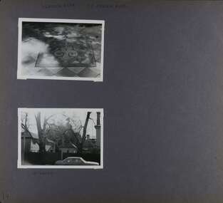 Glen Eira Historical Society
Album - Album page, Heatherbrae, 73 Neerim Road, Circa 1972
... state and surviving outbuildings. "Heatherbrae's" historical significance lies in its link with locally known business man and Shire of Caulfield councillor, John Charles Holland. Its social value rests on its ability to demonstrate a past lifestyle. trevor hart chimneys cast iron columns return verandah garden 1870's neerim road booran road 1880's 1890's mansion john c. holland bluestone foundations italianate iron roofed balcony cast iron balustrade mosaic tiles cast iron lookout flagpole george f griffiths residential villa caulfield heatherbrae victorian style cast iron work stables outbuildings john holland george griffiths councillors mansions Handwritten: "HEATHERBRAE" 73 NEERIM ROAD [top] / STABLE [under bottom photo] / 143 [bottom left] Page 143 of Photograph Album with 2 landscape photographs of Heatherbrae on Neerim Road - paving insignia and side view. ...This photograph is part of the Caulfield Historical Album 1972. This album was created in approximately 1972 as part of a project by the Caulfield Historical Society to assist in identifying buildings worthy of preservation. The album is related to a Survey the Caulfield Historical Society developed in collaboration with the National Trust of Australia (Victoria) and Caulfield City Council to identify historic buildings within the City of Caulfield that warranted the protection of a National Trust Classification. Principal photographer thought to be Trevor Hart, member of Caulfield Historical Society. Most photographs were taken between 1966-1972 with a small number of photographs being older and from unknown sources. All photographs are black and white except where stated, with 386 photographs over 198 pages.From Victorian Heritage Database citation for Heatherbrae HO46 https://vhd.heritagecouncil.vic.gov.au/places/120933 as at (28/10/2020) "Heatherbrae" at 73 Neerim Road, Glenhuntly, is a substantial Victorian residential complex made up of two principal construction stages (pre 1876 and c. 1890) and outbuildings including stables. It is aesthetically, historically and socially significant. Its aesthetic value is demonstrated by the manner in which the two periods of construction survive, the earliest being of greater architectural interest on account of its tower and facade treatment, the latter phase adopting a common villa form. The importance of the complex is heightened by its intact state and surviving outbuildings. "Heatherbrae's" historical significance lies in its link with locally known business man and Shire of Caulfield councillor, John Charles Holland. Its social value rests on its ability to demonstrate a past lifestyle. Page 143 of Photograph Album with 2 landscape photographs of Heatherbrae on Neerim Road - paving insignia and side view.Handwritten: "HEATHERBRAE" 73 NEERIM ROAD [top] / STABLE [under bottom photo] / 143 [bottom left]trevor hart, chimneys, cast iron columns, return verandah, garden, 1870's, neerim road, booran road, 1880's, 1890's, mansion, john c. holland, bluestone foundations, italianate, iron roofed balcony, cast iron balustrade, mosaic tiles, cast iron lookout, flagpole, george f griffiths, residential villa, caulfield, heatherbrae, victorian style, cast iron work, stables, outbuildings, john holland, george griffiths, councillors, mansions -
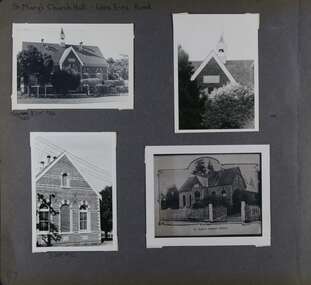 Glen Eira Historical Society
Album - Album page, St Mary's Church Hall, Glen Eira Road, Circa 1972
... stated, with 386 photographs over 198 pages. The Jubilee School on the corner of Hood Crescent and Glen Eira Road was built in 1887 AD to commemorate Queen Victoria’s Jubilee. Victorian Heritage Database https://vhd.heritagecouncil.vic.gov.au/places/43705 The former St Mary's Jubilee School is locally significant as an early purpose built church school, associated with St Mary's Church. Its use of polychrome brick is locally conspicuous whilst the adoption of the Gothic Style not only underlines its Christian foundations ...This photograph is part of the Caulfield Historical Album 1972. This album was created in approximately 1972 as part of a project by the Caulfield Historical Society to assist in identifying buildings worthy of preservation. The album is related to a Survey the Caulfield Historical Society developed in collaboration with the National Trust of Australia (Victoria) and Caulfield City Council to identify historic buildings within the City of Caulfield that warranted the protection of a National Trust Classification. Principal photographer thought to be Trevor Hart, member of Caulfield Historical Society. Most photographs were taken between 1966-1972 with a small number of photographs being older and from unknown sources. All photographs are black and white except where stated, with 386 photographs over 198 pages. The Jubilee School on the corner of Hood Crescent and Glen Eira Road was built in 1887 AD to commemorate Queen Victoria’s Jubilee.Victorian Heritage Database https://vhd.heritagecouncil.vic.gov.au/places/43705 The former St Mary's Jubilee School is locally significant as an early purpose built church school, associated with St Mary's Church. Its use of polychrome brick is locally conspicuous whilst the adoption of the Gothic Style not only underlines its Christian foundations but relates to the comparable schools of the Public Works Department of the same period.Page 57 of Photograph Album with four exterior photographs (2 portrait and 2 landscape) of St Mary's Church Hall. Bottom right photograph is a photo of a photo.Hand written: St Mary's Church Hall - Glen Eira Road [top left] / Neg 233 8 Oct 1966 [under top left photo] / 3 Sept 1972 [under bottom left photo] / bottom right photo titled "St Mary's Sunday School" / 57 [bottom left] trevor hart, 1880's, elsternwick, glen eira road, st kilda east, church of england, st mary's, caulfield north, st mary's anglican church hall, hood crescent, jubilee school, polychrome brickwork, curved windows, church hall, queen victoria’s jubilee, victorian, sunday schools, st mary's jubilee school, gothic style -
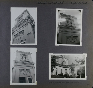 Glen Eira Historical Society
Album - Album page, Nithsdale now Five Way Hill, Kambrook Road, Circa 1972
... stated, with 386 photographs over 198 pages. Glen Eira Heritage Management Plan (1996) by Andrew Ward and Associates - Vol 3 "Nithsdale", built for J.S. Crouchin 1858 and extended in 1885 with a tower and associated rooms, survives as testimony to the nineteenth century occupation of the vicinity of the Kambrook/Glen Eira Road intersection. Caulfield's Building Heritage by Dr Geulah Solomon, Vol 1 p49 records it as a small Victorian mansion home on bluestone foundations...stated, with 386 photographs over 198 pages. Glen Eira Heritage Management Plan (1996) by Andrew Ward and Associates - Vol 3 "Nithsdale", built for J.S. Crouchin 1858 and extended in 1885 with a tower and associated rooms, survives as testimony to the nineteenth century occupation of the vicinity of the Kambrook/Glen Eira Road intersection. Caulfield's Building Heritage by Dr Geulah Solomon, Vol 1 p49 records it as a small Victorian mansion home on bluestone foundations ...This photograph is part of the Caulfield Historical Album 1972. This album was created in approximately 1972 as part of a project by the Caulfield Historical Society to assist in identifying buildings worthy of preservation. The album is related to a Survey the Caulfield Historical Society developed in collaboration with the National Trust of Australia (Victoria) and Caulfield City Council to identify historic buildings within the City of Caulfield that warranted the protection of a National Trust Classification. Principal photographer thought to be Trevor Hart, member of Caulfield Historical Society. Most photographs were taken between 1966-1972 with a small number of photographs being older and from unknown sources. All photographs are black and white except where stated, with 386 photographs over 198 pages. Glen Eira Heritage Management Plan (1996) by Andrew Ward and Associates - Vol 3 "Nithsdale", built for J.S. Crouchin 1858 and extended in 1885 with a tower and associated rooms, survives as testimony to the nineteenth century occupation of the vicinity of the Kambrook/Glen Eira Road intersection. Caulfield's Building Heritage by Dr Geulah Solomon, Vol 1 p49 records it as a small Victorian mansion home on bluestone foundations of Italianate style with a tower. Built for J S Chambers circa 1860, it was built in stages and then the land subdivided in the 1920s. Other owners include Adolph F Brockhoff (of Brockhoff Biscuits company). Names used besides Nithsdale have been Bundoora and Five Way Hill. Page 102 of Photograph Album with four photographs (three landscape and one portrait) of Nithsdale, now known as Five Way Hill. Three views of the tower and one of the house.Handwritten: "Nithsdale" now "Five Way Hill" Kambrook road [top right] / CNR KAMBROOK AND GLENEIRA ROADS [under bottom right photo] / 102 [bottom right]trevor hart, north caulfield, victorian, mid victorian, late victorian, tower, j.s. crouchin, 1850's, 1880's, italianate, rendered, five way hill, nithsdale, slate roof, plaster arches, ornamental columns, triangular pediment, ornamental parapet, cast iron balconies, kambrook road, glen eira road, t crouch, j s crouchin, mansions, j s chambers, bluestone foundations, land subdivision, adolph f brockhoff, bundoora, house names -
 Eltham District Historical Society Inc
Photograph, Tom Prior, Methodist Church, Eltham
... Formerly Wesleyan, Methodist then Uniting church; the foundations of the church building were constructed with stone from the walls of the first Eltham State Primary School (No. 209) building which collapsed in 1874 and were purchased by Robert David Taylor. ...Formerly Wesleyan, Methodist then Uniting church; the foundations of the church building were constructed with stone from the walls of the first Eltham State Primary School (No. 209) building which collapsed in 1874 and were purchased by Robert David Taylor. ...Situated at 810 Main Road on the corner of John Street. The Church was surrounded by a picket fence and tall pine trees. The Church was built by George Stebbings in the 1850s and is an example of fine craftmanship. Formerly Wesleyan, Methodist then Uniting church; the foundations of the church building were constructed with stone from the walls of the first Eltham State Primary School (No. 209) building which collapsed in 1874 and were purchased by Robert David Taylor. The Reynolds/Prior Photograph Collection, Presented to the Eltham District Historical Society, 14 June 2006 by Ross McDonald. A second copy was also presented to the Andrew Ross Museum, Kangaroo Ground The Reynolds family were early settlers in Research. Reynolds Road is named after this family. RERVISED STATEMENT OF SIGNIFICANCE, CONTEXT, 2010 What is significant? The 1880 bichromatic brick church and the surrounding site to the title boundaries. The church is architecturally, historically, socially and spiritually significant to the Shire of Nillumbik. Why is it significant? The church is architecturally significant as a finely detailed example of a brick 19th century rural community church, one of only four in the Shire (Criteria E & B). The church is historically significant as an important link with the time when Eltham was a small, insular country settlement. Also for the historical evolution visible in the complex, with the modest 1880s church and larger red brick rear hall from the early 20th century as a reflection of population growth in the area (Criterion A). The church is historically, spiritually and socially significant because it has played, and continues to play, an important part in the spiritual and social life of the community (Criterion G). - Victorian Heritage Database The Reynolds family were early settlers in Research. The Reynolds/ Prior collection of photographs were taken by Tom Prior, the maternal uncle of Ivy Reynolds, around 1900 and the 60 photos in the album give a fine overview of many of the landmarks of Research and Eltham over 100 years ago. lvy lived in the family home for many years at 106 Thompson Cres Research. Ivy's father, Ernst Richard Reynolds and grandfather, Richard Reynolds, lived at the same address. Ivy's father Richard worked for Mr. Trail on his property in Research. Reynolds Road is named after the family. Mr Tom Prior (wife Eva) worked at the Melbourne zoo. He was very innovative and made his own camera, using the black cloth hood to exclude the light. The photographs are a reminder of the rural nature of Research and Eltham and its rich heritage. Black and white photograph mounted in an album, the Reynolds/Prior Photograph Collection, this being one of 53 reproduced black and white images of early Eltham."Methodist Church" reynolds prior collection, eltham, methodist church -
 Victorian Interpretive Projects Inc.
Photograph-colour, LJ Gervasoni, Jubilee Mine Scarsdale Victoria, 19/03/2011
... Jubilee Company Quartz Gold Mine has one of the most comprehensive range of quartz mining foundations in the State. The brick and concrete foundations cover pumping, winding and crushing operations, as well as cyaniding of mine tailings. ...The Jubilee Mine at Scarsdale was started by Thomas Greenwood of Italian Gully.Jubilee Company Quartz Gold Mine has one of the most comprehensive range of quartz mining foundations in the State. The brick and concrete foundations cover pumping, winding and crushing operations, as well as cyaniding of mine tailings. The machinery foundations are the remnants of large scale quartz mining operations carried on at the site between 1899 to 1912. During this time the mine produced over 125,000 ounces of gold and was the district's most important gold mine. (Source Victorian Heritage Register http://vhd.heritage.vic.gov.au/vhd/heritagevic/?timeout=yes#detail_places;5517)colour photograph in digital format showing the brick foundations of the stamping plant at the Jubilee Mine in Scarsdale, Victoria.gold mine mining scarsdale -
 Flagstaff Hill Maritime Museum and Village
Book, Foundations of The Australian Monetary System 1788-1851
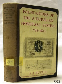
... state significance. Warrnambool Shipwrecked-coast Flagstaff-Hill Flagstaff-Hill-Maritime-Museum Maritime-Museum Shipwreck-coast Flagstaff-Hill-Maritime-Village Shipwrecked-artefact Book Warrnambool Mechanics’ Institute Pattison Collection Warrnambool Library Ralph Eric Pattison Warrnambool City Librarian Mechanics’ Institute Library Victorian Library Board Warrnambool books and records Warrnambool Children’s Library Foundations of The Australian Monetary System S J Butlin Foundations of The Australian Monetary System 1788-1851 Label on spine has typed text PAT 332.49 BUT Pastedown front endpaper has sticker from Corangamite Regional Library Service Foundations of The Australian Monetary System 1788-1851 Author: S J Butlin Publisher: George Robertson Date: 1953 Foundations of The Australian Monetary System 1788-1851 Book ...This item is from the ‘Pattison Collection’, a collection of books and records that was originally owned by the Warrnambool Mechanics’ Institute, which was founded in Warrnambool in 1853. By 1886 the Warrnambool Mechanics’ Institute (WMI) had grown to have a Library, Museum and Fine Arts Gallery, with a collection of “… choice productions of art, and valuable specimens in almost every branch and many wonderful national curiosities are now to be seen there, including historic relics of the town and district.” It later included a School of Design. Although it was very well patronised, the lack of financial support led the WMI in 1911 to ask the City Council to take it over. In 1935 Ralph Pattison was appointed as City Librarian to establish and organise the Warrnambool Library as it was then called. When the WMI building was pulled down in 1963 a new civic building was erected on the site and the new Warrnambool Library, on behalf of the City Council, took over all the holdings of the WMI. At this time some of the items were separated and identified as the ‘Pattison Collection’, named after Ralph Pattison. Eventually the components of the WMI were distributed from the Warrnambool Library to various places, including the Art Gallery, Historical Society and Flagstaff Hill. Later some were even distributed to other regional branches of Corangamite Regional Library and passed to and fro. It is difficult now to trace just where all of the items have ended up. The books at Flagstaff Hill Maritime Village generally display stamps and markings from Pattison as well as a variety of other institutions including the Mechanics’ Institute itself. RALPH ERIC PATTISON Ralph Eric Pattison was born in Rockhampton, Queensland, in 1891. He married Maude Swan from Warrnambool in 1920 and they set up home in Warrnambool. In 1935 Pattison accepted a position as City Librarian for the Warrnambool City Council. His huge challenge was to make a functional library within two rooms of the Mechanics’ Institute. He tirelessly cleaned, cleared and sorted a disarrayed collection of old books, jars of preserved specimens and other items reserved for exhibition in the city’s museum. He developed and updated the library with a wide variety of books for all tastes, including reference books for students; a difficult task to fulfil during the years following the Depression. He converted all of the lower area of the building into a library, reference room and reading room for members and the public. The books were sorted and stored using a cataloguing and card index system that he had developed himself. He also prepared the upper floor of the building and established the Art Gallery and later the Museum, a place to exhibit the many old relics that had been stored for years for this purpose. One of the treasures he found was a beautiful ancient clock, which he repaired, restored and enjoyed using in his office during the years of his service there. Ralph Pattison was described as “a meticulous gentleman whose punctuality, floorless courtesy and distinctive neat dress were hallmarks of his character, and ‘his’ clock controlled his daily routine, and his opening and closing of the library’s large heavy doors to the minute.” Pattison took leave during 1942 to 1942 to serve in the Royal Australian Navy, Volunteer Reserve as Lieutenant. A few years later he converted one of the Museum’s rooms into a Children’s Library, stocking it with suitable books for the younger generation. This was an instant success. In the 1950’s he had the honour of being appointed to the Victorian Library Board and received more inspiration from the monthly conferences in Melbourne. He was sadly retired in 1959 after over 23 years of service, due to the fact that he had gone over the working age of council officers. However he continued to take a very keen interest in the continual development of the Library until his death in 1969. The Pattison Collection, along with other items at Flagstaff Hill Maritime Village, was originally part of the Warrnambool Mechanics' Institute’s collection. The Warrnambool Mechanics’ Institute Collection is primarily significant in its totality, rather than for the individual objects it contains. Its contents are highly representative of the development of Mechanics' Institute libraries across Australia, particularly Victoria. A diversity of publications and themes has been amassed, and these provide clues to our understanding of the nature of and changes in the reading habits of Victorians from the 1850s to the middle of the 20th century. The collection also highlights the Warrnambool community’s commitment to the Mechanics’ Institute, reading, literacy and learning in the regions, and proves that access to knowledge was not impeded by distance. These items help to provide a more complete picture of our community’s ideals and aspirations. The Warrnambool Mechanics Institute book collection has historical and social significance for its strong association with the Mechanics Institute movement and the important role it played in the intellectual, cultural and social development of people throughout the latter part of the nineteenth century and the early twentieth century. The collection of books is a rare example of an early lending library and its significance is enhanced by the survival of an original collection of many volumes. The Warrnambool Mechanics' Institute’s publication collection is of both local and state significance. Foundations of The Australian Monetary System 1788-1851 Author: S J Butlin Publisher: George Robertson Date: 1953 Label on spine has typed text PAT 332.49 BUT Pastedown front endpaper has sticker from Corangamite Regional Library Servicewarrnambool, shipwrecked-coast, flagstaff-hill, flagstaff-hill-maritime-museum, maritime-museum, shipwreck-coast, flagstaff-hill-maritime-village, shipwrecked-artefact, book, warrnambool mechanics’ institute, pattison collection, warrnambool library, ralph eric pattison, warrnambool city librarian, mechanics’ institute library, victorian library board, warrnambool books and records, warrnambool children’s library, foundations of the australian monetary system, s j butlin, foundations of the australian monetary system 1788-1851 -
 Federation University Historical Collection
Photograph - Photograph - Black and White, Mount Pleasant Primary School No 1436, 1874
... Gold was discovered at Caylton's Hill in 1853. mount pleasant primary school mount pleasant state school mount pleasant mt pleasant education clayton's hill bluestone william h. nicholls thomas gray jane shaw jane tratham catherine j. berriman john blight herbert berchaivaise annie hicks albert coates h.e. starke j.g. eagleston Black and white photograph of a primary school in the Ballarat suburb of Mount Pleasant. The brick school is sat on bluestone foundations ...Mount Pleasant Primary School 1435 was formerly known as Clayton's Hill, and evolved from a tent school, commenced in 1855 by William McIntosh. When changed from a Wesyleyan day school to a Common School it was given the number 424, received State funding and was conducted by William H. Nicholls. On 01 January 1873 the school became a non-vested school under control of the Education Department until 31 August 1873. The State then leased the school until 31 July 1874, with the current brick school, Mount Pleasant No.1436, opening on 01 August 1874. The Head Teacher of the new school was William H. Nicholls, remained at the school until 1887. His assistants were Thomas Gray, Jane Shaw, Jane Tratham, Catherine J. Berriman, John Blight, Herbert Berchaivaise and Annie Hicks, all who had worked at Mount Pleasant No. 424. William Nicholls and his assistant Gray established after school classes to enable students to gain Exhibitions and Scholarships to matriculate for the University of Melbourne, and courses enabling entry to teaching, pharmacy and civil service. Before the establishment of State Secondary and Technical Educaiton over 100 pupils from Mount Pleasant Primary School has matiriculated and entered the various professions. (Visions and Realisations, Vol. 2, pg 653 and 767) William Henry Williams became the first classifier of teachers for the Victorian Education Department. He died aged 51 while Head Teacher at Yarra Park Primary School on 01 April 1899. Some former students of this school include: J.G. Eagleston (County Court Judge); H.E. Starke (Judge of the High Court of Australia ); Bernard O'Dowd (parliamentary draughtsman and poet); Albert Coates (Surgeon and Medical Officer in Burmese Prisoner of War Camps). Gold was discovered at Caylton's Hill in 1853.Black and white photograph of a primary school in the Ballarat suburb of Mount Pleasant. The brick school is sat on bluestone foundations.mount pleasant primary school, mount pleasant state school, mount pleasant, mt pleasant, education, clayton's hill, bluestone, william h. nicholls, thomas gray, jane shaw, jane tratham, catherine j. berriman, john blight, herbert berchaivaise, annie hicks, albert coates, h.e. starke, j.g. eagleston -
 Ballarat Tramway Museum
Document, State Electricity Commission of Victoria (SECV), "Bendigo Tramways - Tracks, October 1962
... foundations, road surface, corrosion, road base materials, related photos, joints, flange running and the almost impossible task of maintaining safety within economic bounds. See item 9936 for an associated report drawing VC4/65, dated 25/10/1962. Yields information about the condition of the Bendigo Tramways track in Oct. 1962 tramways trackwork reports Track Materials Tram track construction drawings rails profiles Bendigo Document - three foolscap sheets, stapled in top left hand corner. "Bendigo Tramways - Tracks Document State ...Document titled "Bendigo Tramways - Tracks", dated October 1962, reporting on the history, type of rail used, special work, foundations, road surface, corrosion, road base materials, related photos, joints, flange running and the almost impossible task of maintaining safety within economic bounds. See item 9936 for an associated report drawing VC4/65, dated 25/10/1962.Yields information about the condition of the Bendigo Tramways track in Oct. 1962Document - three foolscap sheets, stapled in top left hand corner.tramways, trackwork, reports, track materials, tram track construction, drawings, rails, profiles, bendigo -
 Flagstaff Hill Maritime Museum and Village
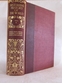
Book - Reference Book/History, Henry Smith Williams, The Historians History of the World Vol 21 set 1 - Edited by Henry Smith Williams L.L.D. Published by “The Times” 1908, 1908
... foundations and social structures that defined early Indian history. Part V: Ancient Persia Covers the rise of the Mede s and the Persians his commentary is on the empire builders focused heavily on the Achaemenid Empire under Cyrus the Great, Darius I, and Xerxes, documenting their massive military expansions and their eventually disastrous conflicts with the Greeks. The set is of historiographical value and significant because it captures the state ...The 1908 edition of The Historians' History of the World is a monumental work of Edwardian scholarship, representing a specific era of "universal history" where the goal was to synthesise all human knowledge into a single narrative. Volume 2 of The Historians' History of the World focuses on "Israel, India, Persia, Phoenicia, Minor Nations of Western Asia."Book is part of a 25 volume set with red cloth bindings and gold filigree design to rib.non-fictionThe 1908 edition of The Historians' History of the World is a monumental work of Edwardian scholarship, representing a specific era of "universal history" where the goal was to synthesise all human knowledge into a single narrative. Volume 2 of The Historians' History of the World focuses on "Israel, India, Persia, Phoenicia, Minor Nations of Western Asia."flagstaff hill, warrnambool, shipwrecked-coast, flagstaff-hill, flagstaff-hill-maritime-museum, maritime-museum, shipwreck-coast, flagstaff-hill-maritime-village, book, the historians history of the world vol 2 set 1 -
 Flagstaff Hill Maritime Museum and Village
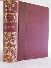
Book - Reference Book/History, Henry Smith Williams, The Historians History of the World Vol 01 set 1 - Edited by Henry Smith Williams L.L.D. Published by “The Times” 1908, 1908
... The Sumerians and Akkadians civilisations and their earliest foundations of law, writing (cuneiform), and city-state governance. ...The Sumerians and Akkadians civilisations and their earliest foundations of law, writing (cuneiform), and city-state governance. ...The 1908 edition of The Historians' History of the World is a monumental work of Edwardian scholarship, representing a specific era of "universal history" where the goal was to synthesise all human knowledge into a single narrative. Volume 1 is titled "Egypt and Mesopotamia," it is divided into two distinct parts Part I concentrates on ancient Egypt, covering the Nile Valley from its legendary beginnings through the various dynasties.Book is part of a 25 volume set with red cloth bindings and gold filigree design to rib.non-fictionThe 1908 edition of The Historians' History of the World is a monumental work of Edwardian scholarship, representing a specific era of "universal history" where the goal was to synthesise all human knowledge into a single narrative. Volume 1 is titled "Egypt and Mesopotamia," it is divided into two distinct parts Part I concentrates on ancient Egypt, covering the Nile Valley from its legendary beginnings through the various dynasties. flagstaff hill, warrnambool, shipwrecked-coast, flagstaff-hill, flagstaff-hill-maritime-museum, maritime-museum, shipwreck-coast, flagstaff-hill-maritime-village, book, the historians history of the world vol 1 set 1 -
 Flagstaff Hill Maritime Museum and Village
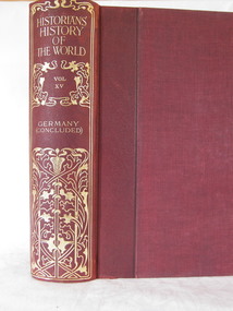
Book - Reference Book/History, Henry Smith Williams, The Historians History of the World Vol 15 set 1 - Edited by Henry Smith Williams L.L.D. Published by “The Times” 1908, 1908
... Following the foundations laid in Volume 14, Volume 15 of “The Historians' History of the World” moves into the heart of modern European power dynamics. Published by The Times in 1908, this volume focuses on the rise of the modern German state and the evolution of the Austrian Empire. ...Following the foundations laid in Volume 14, Volume 15 of “The Historians' History of the World” moves into the heart of modern European power dynamics. Published by The Times in 1908, this volume focuses on the rise of the modern German state and the evolution of the Austrian Empire. ...Henry Smith Williams’ “The Historians' History of the World” is a chronological and geographical "tapestry" of human events, these twenty five volumes occupy a very specific and prestigious place in historical research. Volume 15 of “The Historians' History of the World” moves into the heart of modern European power dynamics. Published by The Times in 1908, this volume focuses on the rise of the modern German state and the evolution of the Austrian Empire.The Book is part of a 25 volume set with red cloth bindings and gold filigree design to rib.non-fictionHenry Smith Williams’ “The Historians' History of the World” is a chronological and geographical "tapestry" of human events, these twenty five volumes occupy a very specific and prestigious place in historical research. Volume 15 of “The Historians' History of the World” moves into the heart of modern European power dynamics. Published by The Times in 1908, this volume focuses on the rise of the modern German state and the evolution of the Austrian Empire.flagstaff hill, warrnambool, shipwrecked-coast, flagstaff-hill-maritime-museum, maritime-museum, shipwreck-coast, flagstaff-hill-maritime-village, book, the historians history of the world vol 15 set 1, henry smith williams -
 Darebin Parklands Association
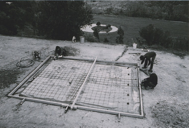
Building 1st ranger's hut, 1979
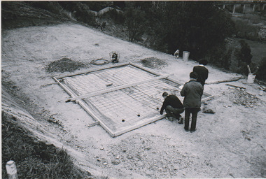
... foundations. This item and all other Darebin Parklands Association archival material is now held by State Library Victoria (Accession No: YMS 13746). ...foundations. This item and all other Darebin Parklands Association archival material is now held by State Library Victoria (Accession No: YMS 13746). ...B&W photograph. Laying the foundations. This item and all other Darebin Parklands Association archival material is now held by State Library Victoria (Accession No: YMS 13746). Please contact State Library Victoria if access is required. -
 Darebin Parklands Association
Building 1st ranger's hut, 1979
... foundations. This item and all other Darebin Parklands Association archival material is now held by State Library Victoria (Accession No: YMS 13746). ...foundations. This item and all other Darebin Parklands Association archival material is now held by State Library Victoria (Accession No: YMS 13746). ...B&W photograph. Laying the foundations. This item and all other Darebin Parklands Association archival material is now held by State Library Victoria (Accession No: YMS 13746). Please contact State Library Victoria if access is required. -
 Wodonga & District Historical Society Inc
Functional object - Jurors' Selection Barrel, Wodonga Court House
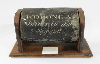
... Foundations for the new court house in Elgin Street were laid in October 1965 Local significance due to its use in the Wodonga Court House and its survival of a major fire. State ...The barrel was used in the Wodonga Court House as part of the selection process for jurors. It was a standard issue barrel used throughout Victoria. It was retrieved from the ruins of the court house which was destroyed by fire. It was then donated to the Wodonga Historical Society. The timber display stand was made and donated by Jake Tooley, a Wodonga Historical Society member, The Court House was situated in the Customs Store building alongside the Wodonga Police Station in 93 High Street. (The house where the Police Station was had originally been the home of the Customs Officer). In early 1964, the court house building was burnt beyond repair and furniture and other property destroyed. The cause of the fire was never found. The Police Station was lucky to survive but only because of the efforts of the local Fire Brigade. After the fire, the court was held first at the old Fire Station premises near where the Wodonga Post Office is near Woodland Grove, then it moved to a vacant building in Mitchell Street which was later turned into a Child Care Centre. Foundations for the new court house in Elgin Street were laid in October 1965 Local significance due to its use in the Wodonga Court House and its survival of a major fire. State significance as it documents a procedure used in the Victorian Court and Legal system Cylindrical metal-iron barrel painted black with writing stenciled on the front in white The timber mount was made for storage and display is not part of the original object,Inscription on Barrel "WODONGA./ Jurors in use./ Special"wodonga court, jurors, selection, legal system, fire -
 Wodonga & District Historical Society Inc
Album - Hume Reservoir Australia Album - Foundations for core wall of earth embankment, September 1921
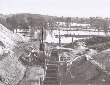
... State for Dominion Affairs on the occasion of his visit to the Hume Reservoir on 2nd November 1927. This album is of local and national significance as it documents the planning and development of the Hume Reservoir up to 1927. It was the largest water reservoir in the British Empire. The album records the pioneering engineering work that went into its construction. Hume Reservoir Australia River Murray Waters Scheme Hume Weir Diagrams Hume Plan Details DEPARTMENT OF PUBLIC WORKS, N.S.W. RIVER MURRAY WATERS SCHEME. HUME RESERVOIR. 5. Foundations ...This set of photos is from a leather bound album bearing the inscription "HUME RESERVOIR AUSTRALIA" plus 'The Rt. Hon. L. C. M. S. Amery, P. C., M .P.' all inscribed in gold. It was presented to The Rt. Hon. L. C. M. S. Amery, P. C., M. P, Secretary of State for Dominion Affairs on the occasion of his visit to the Hume Reservoir on 2nd November 1927. This album is of local and national significance as it documents the planning and development of the Hume Reservoir up to 1927. It was the largest water reservoir in the British Empire. The album records the pioneering engineering work that went into its construction.DEPARTMENT OF PUBLIC WORKS, N.S.W. RIVER MURRAY WATERS SCHEME. HUME RESERVOIR. 5. Foundations for core wall of earth embankment in New South Wales in September 1921. The River Murray in flood.hume reservoir australia, river murray waters scheme, hume weir diagrams, hume plan details -
 Wodonga & District Historical Society Inc
Album - Hume Reservoir Australia Album - Excavations for foundations of spillway, September 1921
... State for Dominion Affairs on the occasion of his visit to the Hume Reservoir on 2nd November 1927. This album is of local and national significance as it documents the planning and development of the Hume Reservoir up to 1927. It was the largest water reservoir in the British Empire. The album records the pioneering engineering work that went into its construction. Hume Reservoir Australia River Murray Waters Scheme Hume Weir Diagrams Hume Plan Details DEPARTMENT OF PUBLIC WORKS, N.S.W. RIVER MURRAY WATERS SCHEME. HUME RESERVOIR. 6. Excavation in progress for foundations ...This set of photos is from a leather bound album bearing the inscription "HUME RESERVOIR AUSTRALIA" plus 'The Rt. Hon. L. C. M. S. Amery, P. C., M .P.' all inscribed in gold. It was presented to The Rt. Hon. L. C. M. S. Amery, P. C., M. P, Secretary of State for Dominion Affairs on the occasion of his visit to the Hume Reservoir on 2nd November 1927. This album is of local and national significance as it documents the planning and development of the Hume Reservoir up to 1927. It was the largest water reservoir in the British Empire. The album records the pioneering engineering work that went into its construction.DEPARTMENT OF PUBLIC WORKS, N.S.W. RIVER MURRAY WATERS SCHEME. HUME RESERVOIR. 6. Excavation in progress for foundations of outlet and spillway sections of dam. September 1921.hume reservoir australia, river murray waters scheme, hume weir diagrams, hume plan details -
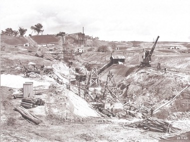 Wodonga & District Historical Society Inc
Album - Hume Reservoir Australia Album - Excavation for Foundations of Core Wall September 1922
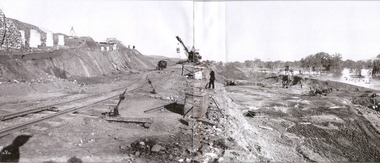
... State for Dominion Affairs on the occasion of his visit to the Hume Reservoir on 2nd November 1927. This album is of local and national significance as it documents the planning and development of the Hume Reservoir up to 1927. It was the largest water reservoir in the British Empire. The album records the pioneering engineering work that went into its construction. Hume Reservoir Australia River Murray Waters Scheme Excavation Hume Reservoir DEPARTMENT OF PUBLIC WORKS, N.S.W. RIVER MURRAY WATERS SCHEME. HUME RESERVOIR. 9. Excavations for foundations ...This set of photos is from a leather bound album bearing the inscription "HUME RESERVOIR AUSTRALIA" plus 'The Rt. Hon. L. C. M. S. Amery, P. C., M .P.' all inscribed in gold. It was presented to The Rt. Hon. L. C. M. S. Amery, P. C., M. P, Secretary of State for Dominion Affairs on the occasion of his visit to the Hume Reservoir on 2nd November 1927. This album is of local and national significance as it documents the planning and development of the Hume Reservoir up to 1927. It was the largest water reservoir in the British Empire. The album records the pioneering engineering work that went into its construction.DEPARTMENT OF PUBLIC WORKS, N.S.W. RIVER MURRAY WATERS SCHEME. HUME RESERVOIR. 9. Excavations for foundations of core wall (in foreground) and part of core wall and earth embankment constructed (in background) in Victoria, September 1922.hume reservoir australia, river murray waters scheme, excavation hume reservoir