Showing 206 items matching " stone well"
-
 Bendigo Historical Society Inc.
Photograph - DWYER COLLECTION: PHOTOCOPY OF IMAGE OF STONE WELL
... DWYER COLLECTION: PHOTOCOPY OF IMAGE OF STONE WELL......photocopy of stone well image...Photocopy of image of stone well, Biffins Track, Maiden Gully. See also 1072.1; 1072.2 and 1072.3....History House 11 Mackenzie Street Bendigo goldfields BENDIGO Buildings photocopy of stone well image Photocopy of image of stone well, Biffins Track, Maiden Gully. ...Photocopy of image of stone well, Biffins Track, Maiden Gully. See also 1072.1; 1072.2 and 1072.3.bendigo, buildings, photocopy of stone well image -
 Bendigo Historical Society Inc.
Document - DWYER COLLECTION: DRAWINGS MAPS AND PHOTOGRAPHS OF STONE WELL MAIDEN GULLY
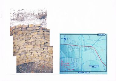
... DWYER COLLECTION: DRAWINGS MAPS AND PHOTOGRAPHS OF STONE WELL MAIDEN GULLY......stone well map...Map on lined writing paper, showing location of stone well in Maiden Gully, on Biffins Track, off Edward Rd., Maiden Gully....History House 11 Mackenzie Street Bendigo goldfields BENDIGO Buildings stone well map Map on lined writing paper, showing location of stone well in Maiden Gully, on Biffins Track, off Edward Rd., Maiden Gully. ...Map on lined writing paper, showing location of stone well in Maiden Gully, on Biffins Track, off Edward Rd., Maiden Gully.bendigo, buildings, stone well map -
 Bendigo Historical Society Inc.
Document - DWYER COLLECTION: LETTER RE STONE WELL LOCATION
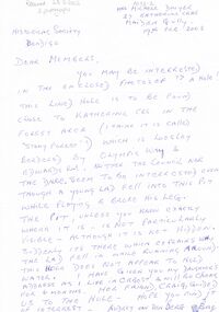
... DWYER COLLECTION: LETTER RE STONE WELL LOCATION......stone well letter...Handwritten letter, blue biro on white paper, describing stone well, Biffins Track, Maiden Gully. Letter is from Mrs. ...History House 11 Mackenzie Street Bendigo goldfields BENDIGO Buildings stone well letter Handwritten letter, blue biro on white paper, describing stone well, Biffins Track, Maiden Gully. ...Handwritten letter, blue biro on white paper, describing stone well, Biffins Track, Maiden Gully. Letter is from Mrs. Michele Dwyer, 27 Katherine Cres., Maiden gully, 19th. Feb. 2003.bendigo, buildings, stone well letter -
 Bendigo Historical Society Inc.
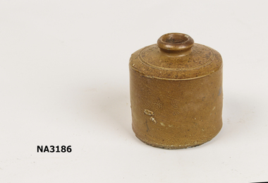
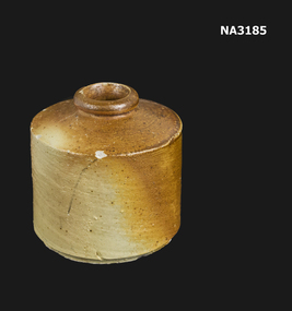
Photograph - DWYER COLLECTION: STONE WELL, MAIDEN GULLY
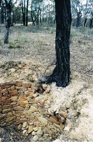
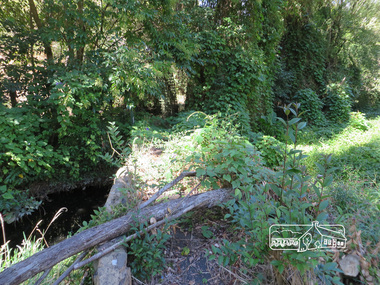
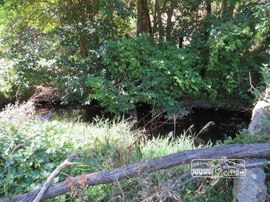
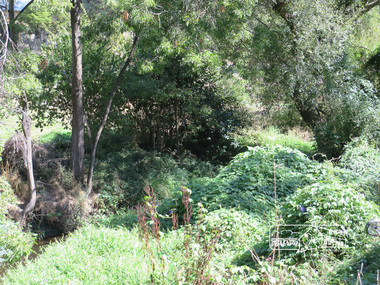
... DWYER COLLECTION: STONE WELL, MAIDEN GULLY......stone well...Photograph: image of stone well, Biffins Track, Maiden Gully. Circular structure lined with sandstone type stones. ...History House 11 Mackenzie Street Bendigo goldfields BENDIGO Buildings stone well Maiden Gully stone well stonework stone cutter. ...Photograph: image of stone well, Biffins Track, Maiden Gully. Circular structure lined with sandstone type stones. Measures 3.7 mt. across at widest point and is approx. 2.7 mt. deep. Large Ironbark on RH side of well. File contains letter from Mrs. Michele Dwyer, 27 Katherine Cres., Maiden Gully, dated 19th. Feb. 2003. Inspection by Kay MacGregor and Phil Wilkin in 2012 revealed well still intact, and on private property, not Crown Land. No heritage listing for well.bendigo, buildings, stone well, maiden gully, stone well, stonework, stone cutter. -
 Whitehorse Historical Society Inc.
Container - Ink Well
... Round stone ware ink well...Whitehorse Historical Society Inc. 2-10 Deep Creek Road Mitcham melbourne From the Betty McPhee writing equipment collection commerce office equipment / stationery domestic items writing equipment Round stone ware ink well Container Ink Well ...From the Betty McPhee writing equipment collectionRound stone ware ink wellcommerce, office equipment / stationery, domestic items, writing equipment -
 Whitehorse Historical Society Inc.
Container - Ink Well
... Round brown stone ware ink well....Whitehorse Historical Society Inc. 2-10 Deep Creek Road Mitcham melbourne From the Betty McPhee office equipment collection commerce office equipment / stationery domestic items writing equipment Round brown stone ware ink well. Container Ink Well ...From the Betty McPhee office equipment collectionRound brown stone ware ink well.commerce, office equipment / stationery, domestic items, writing equipment -
 Bendigo Historical Society Inc.
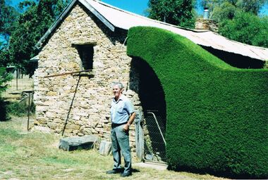
Photograph - PETER ELLIS COLLECTION: STONE BUILDING
... Colour photograph. Stone building. Well trimmed Hedge over gateway. Man Standing in front of gate....History House 11 Mackenzie Street Bendigo goldfields PHOTOGRAPH Building Stone Colour photograph. Stone building. Well trimmed Hedge over gateway. Man Standing in front of gate. ...Colour photograph. Stone building. Well trimmed Hedge over gateway. Man Standing in front of gate.photograph, building, stone -
 Whitehorse Historical Society Inc.
Container - Ink Well
... Round brown coloured stone ware ink well....Whitehorse Historical Society Inc. 2-10 Deep Creek Road Mitcham melbourne From the Betty McPhee writing equipment collection commerce office equipment / stationery domestic items writing equipment Round brown coloured stone ware ink well. Container Ink Well ...From the Betty McPhee writing equipment collectionRound brown coloured stone ware ink well.commerce, office equipment / stationery, domestic items, writing equipment -
 Darebin Parklands Association
Entrance to Rockbeare Park 15th February 1976, Rockbeare Park Conservation Group, 1976
... Ellis Stones, well known landscape designer, designed and supervised the entrance to the Parklands from Rockbeare Grove. ...Alphington melbourne Ellis Stones, well known landscape designer, designed and supervised the entrance to the Parklands from Rockbeare Grove. ...Ellis Stones, well known landscape designer, designed and supervised the entrance to the Parklands from Rockbeare Grove. He designed a winding path but Council insisted on two straight paths for vehicle access.B&W photograph. Annotated with:[RPCG working bee]. Shows children Phil and Gill Course. This item and all other Darebin Parklands Association archival material is now held by State Library Victoria (Accession No: YMS 13746). Please contact State Library Victoria if access is required. -
 Bendigo Historical Society Inc.
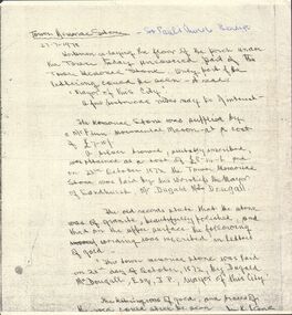
Document - NOTES ON ''TOWER MEMORIAL STONE'' ST PAULS CHURCH, BENDIGO, 27/07/1978
... Article provides text of what was visible on the stone as well as quote from 'old records' about the same stone. ...Article provides text of what was visible on the stone as well as quote from 'old records' about the same stone. ...Handwritten notes on ''Tower Memorial Stone'' - St Pauls Church, Bendigo, dated 27-7-1978. Author (difficult to read - ?? Stone?). Workmen re-laying floor of porch uncovered part of this stone. Article provides text of what was visible on the stone as well as quote from 'old records' about the same stone. Mention of McFinn, Monumental Mason; Duglad McDougall (Mayor). Also costs and description of the stone itself.document, names of bendigo pioneers, tower memorial stone, tower memorial stone. st pauls church. duglad mcdougall -
 Stawell Historical Society Inc
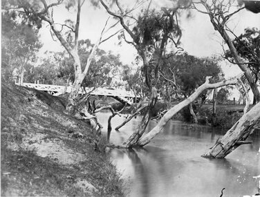
Photograph, Glenorchy Bridge on the Wimmera River 1866
... One was 2 miles on the Stawell side of Glenorchy and 500 metres from the present railway bridge. It was well made, stone floor and can be seen today. The second was located 800 metres downstream of the town and was known as Stuart’s Crossing. ...One was 2 miles on the Stawell side of Glenorchy and 500 metres from the present railway bridge. It was well made, stone floor and can be seen today. The second was located 800 metres downstream of the town and was known as Stuart’s Crossing. ...Glenorchy Bridge Wimmera River. Part of a collection of Photographs by Mr. O.G. Armstrong as commissioned by the Shire of Stawell for the Inter-colonial and Paris Exhibition in Melbourne in 1866. Prior to the construction of this bridge in 1860, there existed two forwards across the Wimmer River at Glenorchy. One was 2 miles on the Stawell side of Glenorchy and 500 metres from the present railway bridge. It was well made, stone floor and can be seen today. The second was located 800 metres downstream of the town and was known as Stuart’s Crossing. These Fords were popular crossing spots for Bullock Drays which were delayed for days during floods before the bridge was built. The original Bridge was built near the site of the present ‘old’ bridge. stawell -
 St Vincent's Hospital Melbourne Archives
Album - Images of the Royal Visit in 1927 and of St Vincent's Hospital Melbourne, the laying of the foundation stone, new wing, 1928
... Page 11, The mallet and the trowel used. Page 12, The stone is well and truly laid, Page 13, Via the enclosure. ...Page 11, The mallet and the trowel used. Page 12, The stone is well and truly laid, Page 13, Via the enclosure. ...Images in the album are related to the laying of the foundation stone of St Vincent's new wing in 1928 as well as the royal visit of the Duke and Duchess of York in 1927. A loose newspaper clipping contained in the album titled "Fitzroy's Welcome" provides information on the royal visit which extended into Fitzroy, Collingwood and Richmond. A minute photo on page 18 of the album shows an image of the royal yacht. Album contents and descriptions written: Page 1, Mother Mary Aikenhead foundress of the Sisters of Charity. Page 2, Mother Mary Berchmans foundress of St Vincent's. Page 3, The Papal Legate Cardinal Cerretti XX1X eucharistic congress laying of the foundation stone SVHM1928. Page 4, His Grace the Archbishop of Melbourne the most Rev Daniel Mannix 1928. Page 5, The stand from which the cardinal addressed the meeting. Page 6, En route to "Stand" SVH. Page 7, The stone ready to be blessed. Page 8, The Cardinal going to bless the stone. Page 9, The blessing of the stone. Page 10, Listening to the Cardinal. Page 11, The mallet and the trowel used. Page 12, The stone is well and truly laid, Page 13, Via the enclosure. Page 14, St V's nurses. Page 15, The Subway. Page 16, En route to Reception Hall. Page 17, The Reception Hall. Page 18, The Stage Garlands, CLC students entertained. Page 19, Royal visit His RH the Duke of York. Page 20, The Duchess of York. Page 21, The living check. Page 22, The guard of honour SVH nurses. Page 23, Fire station en fete opposite SVH. Page 24, Victoria Parade for a Royal Visit.Each page has script style black ink descriptions of the photograph.archbishop daniel mannix, mother mary berchmans daly, cardinal bonaventura cerretti, duke of york, duchess of york, mother mary aikenhead, st vincent's hospital melbourne, nurses, victoria parade, eastern hill fire station., tunnels, brenan hall -
 Eltham District Historical Society Inc
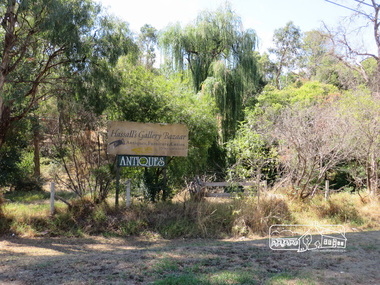
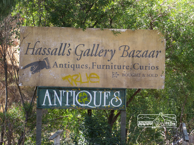
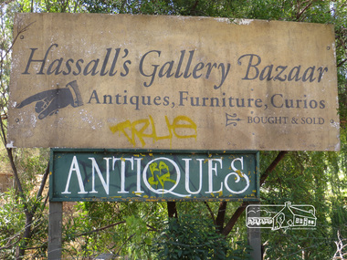
Photograph, Liz Pidgeon, Hassall's Gallery Bazaar, 1215 Main Road, Eltham, 25 March 2014, 25 March 2014
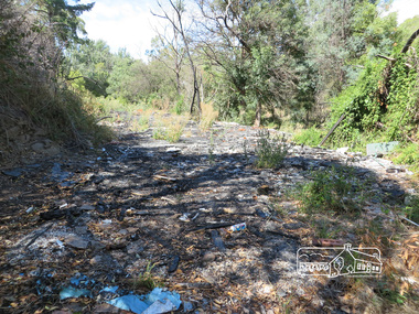
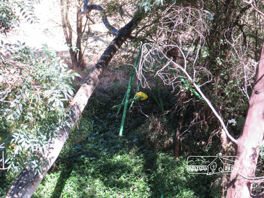
... stone for local road making. Paintings were hung on screens and removed at night for safety. Large pedestals displayed sculpture and jewellery. All types of hand made art work was displayed. Access to the exhibition and grounds was slightly lower than the level of the road. They were encircled by a narrow little moat formed by a small tributary of the Diamond Creek accessed by a small well...stone for local road making. Paintings were hung on screens and removed at night for safety. Large pedestals displayed sculpture and jewellery. All types of hand made art work was displayed. Access to the exhibition and grounds was slightly lower than the level of the road. They were encircled by a narrow little moat formed by a small tributary of the Diamond Creek accessed by a small well ...This is the site of the first roadside art gallery - Hassall's Roadside Gallery created by the artist son of an artist. Ian Hassall was the son of John Hassall who was among and may have been the first of the British poster artists. The gallery opened Saturday July 14, 1962 at 1215 Main road, Eltham by the director of the National Gallery of Victoria, Eric Westbrook. Situated on the left hand side of the main road, about a mile and a half beyond Eltham, towards Research, near Coleman's Corner at the intersection of Wattletree Road. The property has remnants of a stone quarry, probably for the purpose of gaining stone for local road making. Paintings were hung on screens and removed at night for safety. Large pedestals displayed sculpture and jewellery. All types of hand made art work was displayed. Access to the exhibition and grounds was slightly lower than the level of the road. They were encircled by a narrow little moat formed by a small tributary of the Diamond Creek accessed by a small well built stone bridge built by Ian Hassall with local stone. The Gallery later became known as Hassall's Gallery Bazaar antiques, furniture, curios bought and sold. It operated through to the early 1990s. The property has been derelict and neglected for some years. At one stage a shipping container sat near the entrance. This series of ten photographs illustrate the extent of the vegetation which has taken over the land, evidence of rubbish and a possible fire. In July 2017, planning permission was sought from the Shire of Nillumbik for buildings and works to construct a dwelling and associated vegetation removal. (source planningalerts.org.au)Born Digitaleltham, main road, hassall's gallery bazaar -
 Eltham District Historical Society Inc
Photograph, Liz Pidgeon, Hassall's Gallery Bazaar, 1215 Main Road, Eltham, 25 March 2014, 25 March 2014
... stone for local road making. Paintings were hung on screens and removed at night for safety. Large pedestals displayed sculpture and jewellery. All types of hand made art work was displayed. Access to the exhibition and grounds was slightly lower than the level of the road. They were encircled by a narrow little moat formed by a small tributary of the Diamond Creek accessed by a small well...stone for local road making. Paintings were hung on screens and removed at night for safety. Large pedestals displayed sculpture and jewellery. All types of hand made art work was displayed. Access to the exhibition and grounds was slightly lower than the level of the road. They were encircled by a narrow little moat formed by a small tributary of the Diamond Creek accessed by a small well ...This is the site of the first roadside art gallery - Hassall's Roadside Gallery created by the artist son of an artist. Ian Hassall was the son of John Hassall who was among and may have been the first of the British poster artists. The gallery opened Saturday July 14, 1962 at 1215 Main road, Eltham by the director of the National Gallery of Victoria, Eric Westbrook. Situated on the left hand side of the main road, about a mile and a half beyond Eltham, towards Research, near Coleman's Corner at the intersection of Wattletree Road. The property has remnants of a stone quarry, probably for the purpose of gaining stone for local road making. Paintings were hung on screens and removed at night for safety. Large pedestals displayed sculpture and jewellery. All types of hand made art work was displayed. Access to the exhibition and grounds was slightly lower than the level of the road. They were encircled by a narrow little moat formed by a small tributary of the Diamond Creek accessed by a small well built stone bridge built by Ian Hassall with local stone. The Gallery later became known as Hassall's Gallery Bazaar antiques, furniture, curios bought and sold. It operated through to the early 1990s. The property has been derelict and neglected for some years. At one stage a shipping container sat near the entrance. This series of ten photographs illustrate the extent of the vegetation which has taken over the land, evidence of rubbish and a possible fire. In July 2017, planning permission was sought from the Shire of Nillumbik for buildings and works to construct a dwelling and associated vegetation removal. (source planningalerts.org.au)Born Digitaleltham, main road, hassall's gallery bazaar -
 Victorian Aboriginal Corporation for Languages
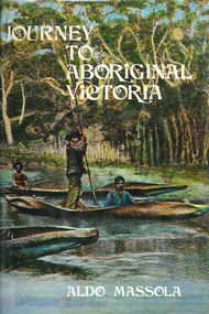
Book, Aldo Massola, Journey to Aboriginal Victoria, 1969
... Pirtkopen-noot tribes, gives legend; stone implements; mill stones; fish weirs; stone arrangement near Lake Wongan; ground drawing of a bunyip, paintings in rock shelter near Mt. Langi Ghiran; Chap.10; Maryborough - camps, oven mounds, rock wells, stone arrangement at Carisbrook; camp sites at Mt. ...Pirtkopen-noot tribes, gives legend; stone implements; mill stones; fish weirs; stone arrangement near Lake Wongan; ground drawing of a bunyip, paintings in rock shelter near Mt. Langi Ghiran; Chap.10; Maryborough - camps, oven mounds, rock wells, stone arrangement at Carisbrook; camp sites at Mt. ...Looks at the Aboriginal community from the time of white contact, across many parts of Victoria. Chap.1; Melbourne - early missions, camp of Native Police, corroboree trees, canoe trees, grave &? headstone of Derrimut; quarries at Keilor, excavation sites at Green Gully &? Keilor; quarry at Mt. William, notes on inheritance of quarries Coranderrk settlement - Barraks grave, notes on his life; Chap.2; Geelong - Yawangi group of the Wothowurong tribe, camping grounds in area quarries; Notes on William Buckley, Gellibrand (a notable Aboriginal), graves in the Western Cemetery; Chap.3; Colac - war between Colac &? Geelong tribes; Mission at Birregurra, reason for failure of Buntingdale Mission; brass plate to Coc-coc-coine; reserve at Elliminyt, native ovens, camp sites, initiation site &? ritual; quarry sites, axegrinding factory, rock pecking &? engraving; dried hand &? 3 Aboriginal skulls found; Chap.4; The south-west coast - middens, camp sites notes on Framlingham Stn., fish traps at Tyrendarra; Chap.5; The far west - massacres of Aborigines near Casterton; camp sites, oven mounds; the first cricket team formed; Aboriginal cemetery; Chap.6; Hamilton - camps; Mount Rouse Station, axegrinding grooves at Nareeb Nareeb, shelters described, fish traps, massacre at Lake Condah; mission; canoes; Chap.7; Camperdown - legend about Lake Bullen Merri; obelisk erected in memory of Aborigines of district especially chief Wombeetch Puyuun; Jarcoort tribe; fish weirs, camps, intertribal fights between Booluc-burrers, Jarcoorts &? Ellengermote groups; bartering place at Mount Noorat; articles traded, legend of Flat-Top Hill; Chap.8; Ballarat - camp at Lake Wendouree; White Stone Lagoon; legends concerning Mt. Buninyong &? waterfalls at Lal-lal; camp sites; pygmy-type implements near Meredith, quarry at Glue Pot Rocks near Durdidwarrah; brass plate of King Billy; Chap.9; Ararat - Tjapwurong territory; camp sites, quarries, shield &? canoe trees; Bunyip belief at Lake Buninjon of Muk-jarawaint &? Pirtkopen-noot tribes, gives legend; stone implements; mill stones; fish weirs; stone arrangement near Lake Wongan; ground drawing of a bunyip, paintings in rock shelter near Mt. Langi Ghiran; Chap.10; Maryborough - camps, oven mounds, rock wells, stone arrangement at Carisbrook; camp sites at Mt. Franklin; Chap.11; Charlton - belief in Mindye (snake); canoe trees, ovens, camp sites, water holes, rock wells, stone implements; method of rainmaking; Chap.12; Horsham-Stawell, The Wimmera - Wotjobaluk land; camps, fish traps at Toolondo; Black Range cave paintings, Flat Rock shelters (detailed account of these paintings); Bunjils Cave; Chap.13; Horsham-Stawell, The Mallee - camp sites, implements; Ebenezer Mission, Willie Wimmera taken to England by Rev. Chase to become a missionary, died in England; Chap.14; The Murray River, Mildura Swan Hill - Battle of the Rufus; ceremonial ground, Lake Gol Gol, canoe &? shield trees; stone implements; camp sites, fire place arrangements; fish traps; oven mounds; Chap.15; The Murray River, Swan Hill-Echuca - legend about Lake Boga; camps, oven mounds, the Cohuna skull, Kow Swamp, method of burial; Chap.16; Shepparton ovens; brass plates of King Paddy of Kotupna &? King Tattambo of Mulka Stn., native well, camps; Chap.17; Wangaratta -camps, quarry, rock holes, the Faithful massacre; grinding rocks at Earlston; Chap.18; The High Plains - Ya-itma-thang; camps, Bogong moth feasts, native paths for trade &? intertribal fights, articles traded; painted shelters; Koetong Ck. Valley, near Mt. Pilot &? near Barwidgee Ck.; Chap.19; Dandenong - water holes, list of 8 holes in Beaumaris - Black Rock area; camps, middens, stone implements (microliths), legend of Angels Cave, stone axes, Native Police Force, Narre Narre Warren Station, legend about rocks on Bald Hill, kangaroo totemic site; Chap.20; Wonthaggi- Yarram - natives visit Phillip Is., murder of William Cook and Yankee by five Tasmanians (listed as Bon Small Boy, Jack Napoleon Timninaparewa, Fanny Waterpoordeyer, Matilda Nattopolenimma and Truganini) near Cape Patterson, men; camp sites, middens, legend of White Rock; Chap.21; Sale - Bairnsdale, The Lakes Country middens, camps; legend at Wulrunjeri; story of a white woman supposedly living with with the Tutangolung tribe, efforts made to prove story; canoe trees; Chap.22; Sale-Bairnsdale, The Inland Braiakolung tribe, camps, implements, canoe &? shield trees; Ramahyuck Mission, grinding rocks, fights with Omeo tribe; native tracks, death through enemy magic - procedure, belief in ghosts; Chap.23; Lakes Entrance and the Country to the east - Kroatungolung people, legend of Kalimna Valley; camps, stones of Nargun, bunyip, devils at Lake Tyers, excavation at Buchan, carbon dates; middens, ochre at Cape Conrad, stone fish-hook file at Thurra River; note on Bidwel tribe; Each chapter gives historical details, early contacts, relationships with settlers; Aboriginal place names and detailed description of sites and geographical features.b&w photographs, b&w illustrations, colour illustrationsgeelong, colac, hamilton, camperdown, ballarat, ararat, maryborough, charlton, horsham, stawell, murray river, shepparton, wangaratta, dandenong, wonthaggi, yarram, sale, bairnsdale, lakes entrance -
 Flagstaff Hill Maritime Museum and Village
Equipment - Sharpening Stone, ca 1878
... The sharpening stone can also be referred to as a whetstone, oil stone or honing stone. It is a well-worn double-sided sharpening stone retrieved from the wreck site of the Loch Ard. ...Flagstaff Hill Maritime Museum and Village 89 Merri Street Warrnambool great-ocean-road The sharpening stone can also be referred to as a whetstone, oil stone or honing stone. It is a well-worn double-sided sharpening stone retrieved from the wreck site of the Loch Ard. ...The sharpening stone can also be referred to as a whetstone, oil stone or honing stone. It is a well-worn double-sided sharpening stone retrieved from the wreck site of the Loch Ard. It is used to grind and hone the edges of metal blades and tools. ‘Natural’ sharpening stones like this one are quarried from ancient sedimentary rock that has metamorphosed from clay and volcanic ash to produce garnet crystals. Most modern stones are artificially produced, or ‘bonded’, abrasive stones, made by fusing clay and metal powder under heat and pressure. The softer yellow Corticule stone is found in thin vertical veins running through the more plentiful Belgian Blue rock. Coticule is a fine-grained and dense material that ‘cuts’ metal slowly but to a superior standard of sharpness and finish. The relatively coarser Belgian Blue is stronger and ‘cuts’ more quickly, but with a less polished finish. A double-sided whetstone is therefore valued for its increased durability (the harder BBW ‘backs’, or supports, the softer Coticule), and additional utility (the fine ‘grit’ of Coticule complements the coarser BBW to meet a range of sharpening needs). The blue-grey base of this stone is thinner than the remaining yellow Coticule on top. This suggests that the majority of grinding and honing work it has done on board the ship was for larger tools, rather than on surgical or shaving blades. Its rounded or spherical shaping may also be related to the ‘tumbling’ action of the sea on the ocean floor. History of the Loch Ard wreck: The Loch Ard got its name from ”Loch Ard” a loch that lies to the west of Aberfoyle, and the east of Loch Lomond. It means "high lake" in Scottish Gaelic. The vessel belonged to the famous Loch Line which sailed many vessels from England to Australia. The Loch Ard was built in Glasgow by Barclay, Curle & Co. in 1873, the vessel was a three-masted square-rigged iron sailing ship that measured 79.87 meters in length, 11.58 m in width, and 7 m in depth with a gross tonnage of 1693 tons with a mainmast that measured a massive 45.7 m in height. Loch Ard made three trips to Australia and one trip to Calcutta before its fateful voyage. Loch Ard left England on March 2, 1878, under the command of 29-year-old Captain Gibbs, who was newly married. The ship was bound for Melbourne with a crew of 37, plus 17 passengers. The general cargo reflected the affluence of Melbourne at the time. Onboard were straw hats, umbrellas, perfumes, clay pipes, pianos, clocks, confectionery, linen and candles, as well as a heavier load of railway irons, cement, lead and copper. There were other items included that were intended for display in the Melbourne International Exhibition of 1880. The voyage to Port Phillip was long but uneventful. Then at 3 am on June 1, 1878, Captain Gibbs was expecting to see land. But the Loch Ard was running into a fog which greatly reduced visibility. Captain Gibbs was becoming anxious as there was no sign of land or the Cape Otway lighthouse. At 4 am the fog lifted and a lookout aloft announced that he could see breakers. The sheer cliffs of Victoria's west coast came into view, and Captain Gibbs realised that the ship was much closer to them than expected. He ordered as much sail to be set as time would permit and then attempted to steer the vessel out to sea. On coming head-on into the wind, the ship lost momentum, the sails fell limp and Loch Ard's bow swung back towards land. Gibbs then ordered the anchors to be released in an attempt to hold their position. The anchors sank some 50 fathoms - but did not hold. By this time the ship was among the breakers and the tall cliffs of Mutton Bird Island rose behind. Just half a mile from the coast, the ship's bow was suddenly pulled around by the anchor. The captain tried to tack out to sea, but the ship struck a reef at the base of Mutton Bird Island, near Port Campbell. Waves subsequently broke over the ship and the top deck became loosened from the hull. The masts and rigging came crashing down knocking passengers and crew overboard. When a lifeboat was finally launched, it crashed into the side of Loch Ard and capsized. Tom Pearce, who had launched the boat, managed to cling to its overturned hull and shelter beneath it. He drifted out to sea and then on the flood tide came into what is now known as Lochard Gorge. He swam to shore, bruised and dazed, and found a cave in which to shelter. Some of the crew stayed below deck to shelter from the falling rigging but drowned when the ship slipped off the reef into deeper water. Eva Carmichael a passenger had raced onto the deck to find out what was happening only to be confronted by towering cliffs looming above the stricken ship. In all the chaos, Captain Gibbs grabbed Eva and said, "If you are saved Eva, let my dear wife know that I died like a sailor". That was the last Eva Carmichael saw of the captain. She was swept off the ship by a huge wave. Eva saw Tom Pearce on a small rocky beach and yelled to attract his attention. He dived in and swam to the exhausted woman and dragged her to shore. He took her to the cave and broke the open case of brandy which had washed up on the beach. He opened a bottle to revive the unconscious woman. A few hours later Tom scaled a cliff in search of help. He followed hoof prints and came by chance upon two men from nearby Glenample Station three and a half miles away. In a complete state of exhaustion, he told the men of the tragedy. Tom then returned to the gorge while the two men rode back to the station to get help. By the time they reached Loch Ard Gorge, it was cold and dark. The two shipwreck survivors were taken to Glenample Station to recover. Eva stayed at the station for six weeks before returning to Ireland by steamship. In Melbourne, Tom Pearce received a hero's welcome. He was presented with the first gold medal of the Royal Humane Society of Victoria and a £1000 cheque from the Victorian Government. Concerts were performed to honour the young man's bravery and to raise money for those who lost family in the disaster. Of the 54 crew members and passengers on board, only two survived: the apprentice, Tom Pearce and the young woman passenger, Eva Carmichael, who lost her family in the tragedy. Ten days after the Lochard tragedy, salvage rights to the wreck were sold at auction for £2,120. Cargo valued at £3,000 was salvaged and placed on the beach, but most washed back into the sea when another storm developed. The wreck of Lochard still lies at the base of Mutton Bird Island. Much of the cargo has now been salvaged and some items were washed up into Lochard Gorge. Cargo and artefacts have also been illegally salvaged over many years before protective legislation was introduced in March 1982. One of the most unlikely pieces of cargo to have survived the shipwreck was a Minton majolica peacock- one of only nine in the world. The peacock was destined for the Melbourne 1880 International Exhibition. It had been well packed, which gave it adequate protection during the violent storm. Today the Minton peacock can be seen at the Flagstaff Hill Maritime Museum in Warrnambool. From Australia's most dramatic shipwreck, it has now become Australia's most valuable shipwreck artifact and is one of very few 'objects' on the Victorian State Heritage Register. The shipwreck of the Loch Ard is of significance for Victoria and is registered on the Victorian Heritage Register ( S 417). Flagstaff Hill has a varied collection of artefacts from Loch Ard and its collection is significant for being one of the largest accumulation of artefacts from this notable Victorian shipwreck of which the subject items are a small part. The collections objects give us a snapshot of how we can interpret the story of this tragic event. The collection is also archaeologically significant as it represents aspects of Victoria's shipping history that allows us to interpret Victoria's social and historical themes of the time. Through is associated with the worst and best-known shipwreck in Victoria's history. A sharpening stone is also called a whetstone, oil, or honing stone. The stone is a worn double-sided rectangular block with rounded corners. There is a clear delineation between its coarser Belgian Blue base (grey colour) and its finer Belgian Coticule face (yellow colour). It bears sedimentary encrustation over one-third of its surface. flagstaff hill, warrnambool, shipwrecked coast, flagstaff hill maritime museum, maritime museum, shipwreck coast, flagstaff hill maritime village, great ocean road, loch line, loch ard, captain gibbs, eva carmichael, tom pearce, glenample station, mutton bird island, loch ard gorge, sharpening stone, whetstone, oilstone, double-sided stone, belgian coticule, belgian blue whetstone, oil stone, honing stone -
 Warrnambool and District Historical Society Inc.
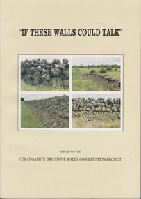
Book, If These Walls Could Talk, 1995
... It contains a large number of black and white photographs of stone walls from around the district as well as maps. ...It contains a large number of black and white photographs of stone walls from around the district as well as maps. If These Walls Could Talk Book Book ...This publication is a result of funding made to the Corangamite Arts Council in 1990-91. Its aims were to identify and research the dry stone walls of the region, to raise their profile and through workshops continue the skills of those wanting to learn more about the craft. The book gives the history of the practice in the area and the various different styles with photographs to illustrate the different features. It also has a number of first- hand accounts written by stonewallers.This study has social, historical, artistic and interpretive significance as the walls are an important feature of the district. The account written by former builders of the walls provides an interesting insight into the various styles and reasons for their construction.Light green card cover. Front cover has 4 photographs of dry stone walls with title and other text in black. Back cover is plain. 144 pages. It contains a large number of black and white photographs of stone walls from around the district as well as maps. Report of the Corangamite dry stone walls Conservation project.dry stone walls, corangamite stone walls, warrnambool and district history, constructing dry stone walls -
 Warrnambool and District Historical Society Inc.
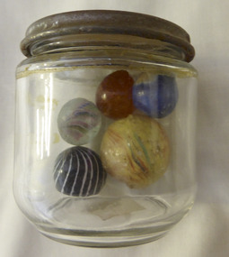
Mixed media - Toy, Marbles, Late 19th century
... There is evidence of the game of marbles in the ruins of Pompeii and the tombs of Egyptians as well as early American Indians. The earliest marbles were simply rounded stones which had been polished but this was refined to handmade versions made of clay, stone and glass. ...Warrnambool and District Historical Society Inc. 2 Gilles Street (south of Merri St) Warrnambool great-ocean-road There is evidence of the game of marbles in the ruins of Pompeii and the tombs of Egyptians as well as early American Indians. The earliest marbles were simply rounded stones which had been polished but this was refined to handmade versions made of clay, stone and glass. ...There is evidence of the game of marbles in the ruins of Pompeii and the tombs of Egyptians as well as early American Indians. The earliest marbles were simply rounded stones which had been polished but this was refined to handmade versions made of clay, stone and glass. It was in the late 19th century that mass production began and it gives testament to the popularity of the game that the Dyke factory of Ohio could produce 1,000,000 marbles a day. It was around 1915 that the mass production of glass marbles began. The game reached the height of popularity in the 1920-1930’s. Many were prized for their designs.The game of marbles was one of the most common games played universally, from childhood hence has a strong link with people of all ages and cultures. Five marbles in glass jar. All are various sizes ranging from large yellow streaked with red and blue, black striped with white, marbled tan, clear with multi coloured streaks and bright blue. Shapes are roughly spherical. Materials range from glass to glazed and stone. Three have pontil marks either on end.The lid of the jar has Nestle vacuumed sealed for extra protection. Use special key to open. Old sticker on base with 173 written in black lead pencil. toys, marbles, children's games, warrnambool, handmade marbles, glass marbles, clay marbles, agate marbles -
 Warrnambool and District Historical Society Inc.
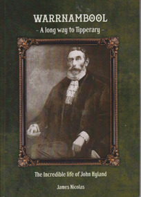
Book, Warrnambool A Long way to Tipperary The incredible life of John Hyland, 2014
... stone of the Warrnambool Town Hall. He campaigned for the vote for women and home rule in Ireland. He is one of 204 early pioneers commemorated on the Pioneer Board. This book tells the story of one of Warrnambool’s most influential early settlers. It records his public and personal life as well ...Biography of early Warrnambool settler, John Hyland.Paperback Background is dark green with sepia photo in bronze coloured frame. Precis on back cover is printed in white lettering. 132 pages.non-fictionBiography of early Warrnambool settler, John Hyland.warrnambool, john hyland, james nicholas, warrnambool mayors -
 Warrnambool and District Historical Society Inc.
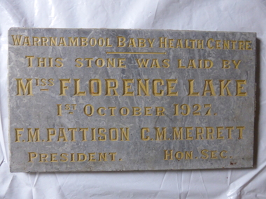
Plaque- Warrnambool Baby Health Centre, Miss Florence Lake 1927, 1927
... well known around the district for her good nature and humour. As her sister married and moved to Italy, she continued to run Lyndoch as it had always been. She died in November 1946 This plaque has historical and social significance as it notes the time in the history of Warrnambool when health came to the fore of public interest and importance. It also commemorates one of Warrnambool's better known citizens and the beginnings of the maternal health system in the city warrnambool warrnambool baby health centre sister riley florence lake Warrnambool Baby Health Centre. This stone ...in the early part of the 20th century, Warrnambool's residents had their share of health problems.according to the Annual report by Dr H I Holmes in 1921. Diphtheria, typhoid fever, tuberculosis, polimyelitis and scarlet fever were common afflictions. The sanitary system or lack thereof was the primary source of much of this illness. The healthcare facilites were much better and the hospital was well run and was further improved by the opening of the baby health centre which was opened in October 1921. The centre was situated in Liebig street at the Town Hall and was open three days a week to offer advice to mothers regarding their babies. and Sister Riley was in charge. Miss Florence Lake who opened the centre was a well known resident of the town and generous benefactor of the Warrnambool base hospital.. Florence along with her sister inherited the Lyndoch estate from George and Annie rolfe in 1920. She was well known around the district for her good nature and humour. As her sister married and moved to Italy, she continued to run Lyndoch as it had always been. She died in November 1946 This plaque has historical and social significance as it notes the time in the history of Warrnambool when health came to the fore of public interest and importance. It also commemorates one of Warrnambool's better known citizens and the beginnings of the maternal health system in the cityThis heavy stone plaque grey in colour, with polished surface, is rectangular, with lettering cut and coloured in gold. all the lettering is in capitals. It is possibly graniteWarrnambool Baby Health Centre. This stone was laid by Miss Florence Lake 1st October 1927. F M Pattison President, C M Merrett Hon Sec.warrnambool, warrnambool baby health centre, sister riley, florence lake -
 Warrnambool and District Historical Society Inc.
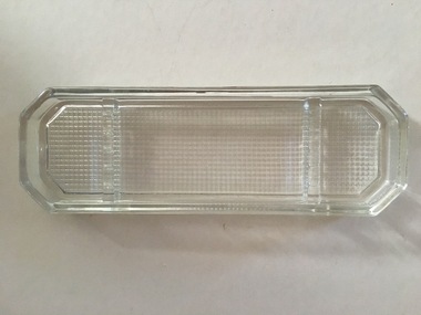
Ink Well, Pen & Ink set, clear glass & black tray
... The lids are metal with metal hinges and polished black stone tops Pen & Ink set, clear glass & black tray Ink Well ...Pen and ink sets were common household and business items in the 19th century and up to the mid 20th century (prior to the introduction of ballpoint pens). They would have been placed on a writing desk or table. The items here are attractive ones and would have been a relatively expensive purchase.These items are connected to the Toleman family from Warrnambool and may have been used by the donor’s father who was an accountant. These are four items:- .1 An oblong glass dish, partly rounded at the ends and with a criss-cross pattern on the base. Inside the dish, towards the ends, are two ridges for holding four pens or pencils. .2 An oblong polished black stone tray with a curved front and a ridge for holding a pen. On the oblong section are two square metal bases with four side clips on each to hold the inkwells. These metal pieces are attached to the black tray with metal screws. .3 & .4 Two glass (crystal?) cubes with a hollow inside for holding ink. The tops of the cubes are metal with circular openings. The lids are metal with metal hinges and polished black stone topshistory of warrnambool, writing implements and associated items, household items from the past