Showing 4 items matching " street beautification scheme"
-
 Glen Eira Historical Society
Document - GLEN HUNTLY (HISTORY OF)
... ... Street Beautification Scheme...(Urban Planning Officer) Glen Huntly Shopping Centre Sculptures Street Beautification Scheme “Flying the Yellow Flag” Moore Olive “Return to Rosstown” Jowett D. ...This file contains one item: 1/A loose-leaf, 23-page document titled ‘The History of Glen Huntly’, by Alfred R. Jones, dated 20/06/1991, describing the history of the suburb. The author has drawn heavily from the 4 sources noted in the bibliography. Subjects covered include the ship the suburb is named after, the suburb’s State School, the suburb’s churches, the Rosstown Railway and Sugar Mill, the origin of the name of Carnegie, the suburb’s aerodrome, and the beautification of the Glen Huntly Shopping Centre. The final 12 pages consist of 9 appendices relating to the aforementioned subjects. Appendix A is a typewritten letter from Ron McLeod, secretary of the Place Names Committee, to Mr. D. R. Aylen, CEO of the City of Caulfield, notifying the latter of the alteration of the name ‘Glenhuntly’ to ‘Glen Huntly’. Appendix B is a list of the ministers of St. David’s Uniting Church from its formation in 1916 to the present. Appendix C identifies the persons portrayed in St. David’s stained glass windows. Appendix D is a poster announcing the auction of 41 blocks of land between Hawthorn and Bambra Road formerly owned by William Ross, plus a map identifying said land blocks and another for locality. Appendix E is an A4 plan of the Rosstown Railway. Appendix F is a drawing of the Rosstown Sugar Mill. Appendix G is a poem titled ‘The Swagman’s Retreat’, by Herb Arnott, about the failure of the Mill. Appendix H is a map of Caulfield’s horse tramways plus a list of opening and closing dates. Appendix J is a list of streets explaining the meanings of their names.glen huntly, glenhuntly, local history, ‘glen huntly’ (ship), ‘glen huntlely’ (ship), quarantine stations, glen huntly road, lake street, mernda avenue, glen huntly state school no. 3703, ormond francis, ormond, garden avenue, grange road, churches, congregational church, glen huntly presbyterian church, st. david’s, st. david’s uniting church, anglican church, jenkin william ‘boss’, methodist church, wattle avenue, smith a. w. mr., glen huntly post office, glen huntly road, king f. l. mr., uniting church, child care centre, presbyterian church of eastern australia, glen huntly methodist church, sun aria, miller mary, stained glass, phrenologists, trinity congregational church, primitive methodists, ‘the victorian independent’, mercy mr., greek orthodox original old calendar church, wanalta road, salvation army, halls, myrtle street, catholic church, st. anthony’s roman catholic church, foundation stones, neerim road, mannix archbishop, st. agnes’ anglican church, booran road, sunday schools, clergy residences, ‘see’ anglican news magazine, lees archbishop, booth archbishop, glen huntly presbyterian church, el nido grove, tennis courts, bollard v. w. right rev., waratah avenue, royal avenue, munster avenue, james street, rothschild street, peace memorial organ, singers, bremner marie, scotland betty, carden joan, rosstown railway, south caulfield, plants, marata road, curraweena road, bambra road, ross william murray, ross leila, ross constance, vautin constance, ‘the grange’, north road, leila road, wild cherry road, caulfield roads board, elsternwick, land sales, sugar mills, koornang road, woornack road, elsternwick railway station, riddell parade, clarence street, dover street, oakleigh road, murrumbeena crescent, carlisle crescent, railways, trains, parks and reserves, caulfield council, sussex street, caulfield city council, swamps, rosstown sugar mill, rosstown estate, ‘the swagman’s retreat’, arnott herb, rosstown, carnegie, ‘ross’s folly’, carnegie andrew, rosstown hotel, dandenong road, rosstown road, rosstown plate horse race, caulfield racecourses, ames avenue, rosstown court, hostels, murrumbeena, cinemas, innovations (cabinetry film), films, music, pianos, manchester grove, safeway store, squash courts, airports, lord reserve, aeroplanes, air navigation act 1921, neville street, larkin sopwith aviation company of australasia, lyons street, morgan street, bookmakers, nightsoil, poultry, weatherboard buildings, glen huntly railway station, rosedale avenue, rifle clubs, scout groups, 1st glen huntly troop, ana, dowding jack mr., glen huntly infant welfare and family planning clinic, vermador private hospital, watson grove, rowlands (drapers), bones plant nursery, caulfield railway station, bridges, trams, horse tramways, glen eira road, elsternwick railway station, kooyong road, aboriginal peoples, truganini road, hannan lyn mrs. (urban planning officer), glen huntly shopping centre, sculptures, street beautification scheme, “flying the yellow flag”, moore olive, “return to rosstown”, jowett d. f., weickhardt i. s., “from sand swamp and health”, murray peter r., wells john c., caulfield historical society, newsletters, place names committee, mcleod ron, aylen d. r. mr., jones hugh rev., king joseph, scarfe james, vertigan sidney, vertigan earle, rance victor, flavell cameron, denholm robin, moorhead ken, taliai siupeli, eccles james leslie, little agnes, hutchins william r., dickie may a., gordon ivey agnes, theobald a. a. mrs., brownbill lloyd norman, ash georgette, land sales, auctions, messrs. crews & arkle, street names -
 Bendigo Historical Society Inc.
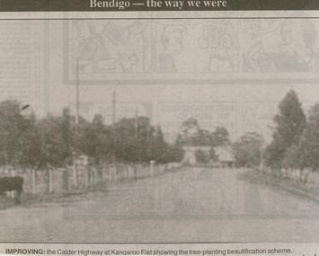
Newspaper - JENNY FOLEY COLLECTION: IMPROVING
... History House 11 Mackenzie Street Bendigo goldfields NEWSPAPER Bendigo advertiser the way we were Bendigo Advertiser ''The way we were'' from 2000. Improving: The Calder Highway at Kangaroo Flat showing the tree planting beautification scheme. ...Bendigo Advertiser ''The way we were'' from 2000. Improving: The Calder Highway at Kangaroo Flat showing the tree planting beautification scheme. The clip is in a folder.newspaper, bendigo advertiser, the way we were -
 Federation University Historical Collection
Book, Back to Bacchus Marsh, 1957, 1957
... Images include: * Grant Street Avenue *St Bernard's new Parish Hall and Schoolrooms * Maddingley No. 2 Cut * Terracing at Maddingley - part of the beautification scheme at Maddingley * Hospital entrance with War memorial Feature * Old Woolpack Inn * Jim Pyke * Infant Welfare and pre-School Centre, Young St * Bacchus Marsh Main Street looking East, 1872 * Andrew George Scott, alias Captain Moonlight * Grant Street Avenue * Ballarat State School No 28 featuring the World War One Memorial Clock ...Images include: * Grant Street Avenue *St Bernard's new Parish Hall and Schoolrooms * Maddingley No. 2 Cut * Terracing at Maddingley - part of the beautification scheme at Maddingley * Hospital entrance with War memorial Feature * Old Woolpack Inn * Jim Pyke * Infant Welfare and pre-School Centre, Young St * Bacchus Marsh Main Street looking East, 1872 * Andrew George Scott, alias Captain Moonlight * Grant Street Avenue * Ballarat State School No 28 featuring the World War One Memorial Clock Back to Bacchus Marsh, 1957 Book Crisp and sons ...A back to Bacchus Marsh was held from 12 to 20 October 1957.Brown covered book of 28 pages including the official programme for back to Bacchus Marsh, 1957. The book includes an historical essay, Maddingley Brown Coal, World war 11, Darley Military Camp, Darley Firebrick Co., industrial changes and numerous advertisements. Images include: * Grant Street Avenue *St Bernard's new Parish Hall and Schoolrooms * Maddingley No. 2 Cut * Terracing at Maddingley - part of the beautification scheme at Maddingley * Hospital entrance with War memorial Feature * Old Woolpack Inn * Jim Pyke * Infant Welfare and pre-School Centre, Young St * Bacchus Marsh Main Street looking East, 1872 * Andrew George Scott, alias Captain Moonlight * Grant Street Avenue * Ballarat State School No 28 featuring the World War One Memorial Clock maddingley brown coal, world war 11, old woolpack inn, darley military camp, darley firebrick, jim pyke, andrew george scott, captain moonlite, bacchus marsh, world war, bacchus marsh state school no 28, grant street avenue, bacchus marsh war memorial hospital, bacchus marsh avenue of honour, captain bacchus -
 Kew Historical Society Inc
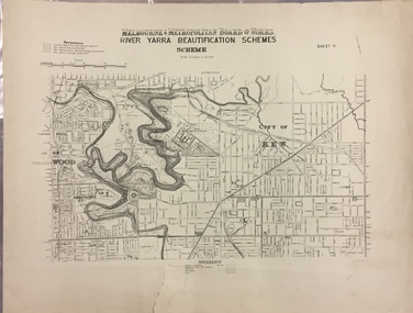
Map, MMBW, River Yarra Beautification Schemes, c.1913
... Beautification Schemes. The map shows development to date and the flood levels reached in 1923 and 1924. This map may have been adapted from an earlier map, as most development in central Kew and Studley Park had occurred by this date yet numerous streets are not represented. ...BEAUTIFICATION SCHEMES / SCHEME / SCALE 10 CHAINS TO AN INCH Map of the City of Kew showing part of the River Yarra Beautification Schemes. The map shows development to date and the flood levels reached in 1923 and 1924. This map may have been adapted from an earlier map, as most development in central Kew and Studley Park had occurred by this date yet numerous streets are not represented. ...The Melbourne and Metropolitan Board of Works (MMBW) was established by an act of the Victorian Parliament in 1890 to prepare for and to implement a sewerage and water reticulation system across what was then inner Melbourne, its surrounding and middle distance suburbs, including Kew. The MMBW was disbanded in 1991.The map collection of the Kew Historical Society has at its core the historic maps assembled and originally stored in the City Engineer's Department of the City of Kew. These include maps in a number of scales. The vast majority of maps were produced by the MMBW in the first two decades of the twentieth century, and are solid working maps, backed by linen for durability. These maps are historically significant to Kew, the City of Boroondara and to the history of the development of state utilities in Victoria. A number of the Kew maps have additional details added by former municipal officers, including the levels reached by various floods. As these were working documents, information was added to them long after the period of their initial production and distribution.Map of the City of Kew showing part of the River Yarra Beautification Schemes. The map shows development to date and the flood levels reached in 1923 and 1924. This map may have been adapted from an earlier map, as most development in central Kew and Studley Park had occurred by this date yet numerous streets are not represented. Public buildings and institutions are clearly represented and named on the map as are significant public transport infrastructure (eg the Outer Circle railway).MELBOURNE AND METROPOLITAN BOARD OF WORKS / RIVER YARRA BEAUTIFICATION SCHEMES / SCHEME / SCALE 10 CHAINS TO AN INCHmelbourne & metropolitan board of works, mmbw maps, mmbw plans, city of kew, flood levels -- kew (vic.), cartography