Showing 323 items matching " sub divisions"
-
 Whitehorse Historical Society Inc.
Article, Prized Penllyne Avenue, 1991
... Built on a double block its potential lies in sub-divisional qualities....Built on a double block its potential lies in sub-divisional qualities....Built on a double block its potential lies in sub-divisional qualities. Prized Penllyne Avenue Article Article ...28 Penllyne Avenue, Vermont, built in 1952 is for sale. Its owners ran the doll hospital in Royal Arcade.28 Penllyne Avenue, Vermont, built in 1952 is for sale. Its owners ran the doll hospital in Royal Arcade. Built on a double block its potential lies in sub-divisional qualities.28 Penllyne Avenue, Vermont, built in 1952 is for sale. Its owners ran the doll hospital in Royal Arcade. penllyne avenue, vermont, no 28, auctions -
 Surrey Hills Historical Society Collection
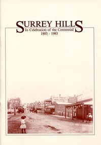
Book, Surrey Hills: in celebration of the centennial 1883-1983, 1983
... It includes early rural properties and diaries, the coming of the railway, land sub-division and early homes, schools, parks and recreation....It includes early rural properties and diaries, the coming of the railway, land sub-division and early homes, schools, parks and recreation....It includes early rural properties and diaries, the coming of the railway, land sub-division and early homes, schools, parks and recreation. ...A pictorial history of Surrey Hills based on information collected and based at the Surrey Hills Neighbourhood Centre. It includes early rural properties and diaries, the coming of the railway, land sub-division and early homes, schools, parks and recreation.A pictorial history of Surrey Hills based on information collected and based at the Surrey Hills Neighbourhood Centre. It includes early rural properties and diaries, the coming of the railway, land sub-division and early homes, schools, parks and recreation.surrey hills, railways, land use, migrants, spanish communities, transport, houses, wattle park, festivals and celebrations, churches, education, water supply, fire stations, hospitals, (mr) george klepper, ainger family, (mr) john woodhead, (mr) h. breedon, medical services, real estate agents, businesses, musical events and activities, entertainment, parks and reserves, scouts, guides -
 Surrey Hills Historical Society Collection
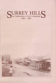
Book, Surrey Hills: in celebration of the centennial 1883-1983, Reprinted November 1992
... It includes information about early rural properties and dairies, the coming of the railway, land sub-division and early homes, doctors, schools, churches, parks and recreation facilities....It includes early rural properties and diaries, the coming of the railway, land sub-division and early homes, schools, parks and recreation....It includes early rural properties and diaries, the coming of the railway, land sub-division and early homes, schools, parks and recreation. ...A pictorial history of Surrey Hills and Mont Albert based on information collected by the history group at the Surrey Hills Neighbourhood Centre. It includes information about early rural properties and dairies, the coming of the railway, land sub-division and early homes, doctors, schools, churches, parks and recreation facilities.A pictorial history of Surrey Hills based on information collected and based at the Surrey Hills Neighbourhood Centre. It includes early rural properties and diaries, the coming of the railway, land sub-division and early homes, schools, parks and recreation.1992surrey hills, railways, land use, migrants, spanish communities, transport, houses, wattle park, festivals and celebrations, churches, education, water supply, fire stations, hospitals, (mr) george klepper, ainger family, (mr) john woodhead, (mr) h. breedon, medical services, real estate agents, businesses, musical events and activities, entertainment, parks and reserves, scouts, guides -
Glen Eira Historical Society
Article - Jennings, Albert Victor
... ... Sub divisions...Jannings Albert Victor Sub divisions Builder Dentist Carnegie Caulfield Murrumbeena A. ...This file contains two items. 1. Computer printout on position of monument to Sir Albert Victor Jennings in Willetton, Western Australia. Also includes brief history on his housing company. 2. Photocopied article from The Australian Financial Times, dated 07/08/1961, on the life and building career and ventures of A. V. Jennings.jannings albert victor, sub divisions, builder, dentist, carnegie, caulfield, murrumbeena, a. v. jennings (aust) ltd., jennings estates and finance ltd., jennings victor, jennings douglas, monuments, memorials -
Glen Eira Historical Society
Article - CARNEGIE
... ... Sub Divisions...Fine View Estate' Sub Divisions Ormond Carnegie Station Houses Housing estates Trams Glen Huntly tram Shops Crystal Palace Theatre Caulfield State school Article CARNEGIE ...Four items about unconnected events in Carnegie dating from 1924 to 2011: 1/Photocopied flyers about forthcoming FINE VIEW ESTATE subdivision held on 29/03/1924, includes photocopied photos. 2/Cardboard flyer advertising Carnegie’s community singing at the Progress Hall, Truganini Road. 3/Newspaper article dated 19/03/1980 from the CHADSTONE PROGRESS on Robert Temminghoff, the new president of the Carnegie Chamber of Commerce. 4/MELBOURNE WEEKLY BAYSIDE 06/04/2011, an article on Carnegie, beginnings and other relevant facts.fine view estate', sub divisions, ormond, carnegie station, houses, housing estates, trams, glen huntly tram, shops, crystal palace theatre, caulfield, state school -
Clunes Museum
Document
... CRESWELL, MINING REGISTRAR OF CLUNES SUB-DIVISION OF QUARTZ MINES 1886 ...CRESWELL, MINING REGISTRAR OF CLUNES SUB-DIVISION OF QUARTZ MINES 1886 Document DOCUMENT ....1 EXTRACT REPORTS COMPILED BY C.A.C. CRESWELL, MINING REGISTRAR OF CLUNES SUB-DIVISION OF QUARTZ MINES 1883 .2 EXTRACT REPORTS COMPILED BY C.A.C. CRESWELL, MINING REGISTRAR OF CLUNES SUB-DIVISION OF QUARTZ MINES 1884 .3 EXTRACT REPORTS COMPILED BY C.A.C. CRESWELL, MINING REGISTRAR OF CLUNES SUB-DIVISION OF QUARTZ MINES 1886 Handwritten; .1 1883 .2 1884 .3 1886local history, document, mining, quartz mines, cac creswell -
 Glen Eira Historical Society
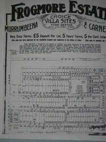
Frogmore Estate
... Photocopy of sub division plan of Frogmore Estate in Murrumbeena and Carnegie, date unknown...Glen Eira Historical Society 965 Glen Huntly Rd Caulfield VIC 3162 melbourne Murrrumbeena Carnegie Frogmore Estate Land Subdivision Photocopy of sub division plan of Frogmore Estate in Murrumbeena and Carnegie, date unknown Frogmore Estate ...Photocopy of sub division plan of Frogmore Estate in Murrumbeena and Carnegie, date unknownmurrrumbeena, carnegie, frogmore estate, land subdivision -
 Whitehorse Historical Society Inc.
Photograph, Sub-division of the former Mitcham Technical School, C.1996
... Sub-division of the former Mitcham Technical School, C.1996....Sub-division of the former Mitcham Technical School, C.1996 - looking north....Sub-division of the former Mitcham Technical School, C.1996. ...Sub-division of the former Mitcham Technical School, C.1996 - looking north.mitcham technical school, knightsbridge subdivision, nunawading, cherrybrook close -
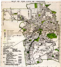 Croydon Conservation Society Inc.
Map, City of Croydon map and subdivision map, September 1961 or 1981
... Two pages, one page map of Croydon and one page a sub division...Two pages, one page map of Croydon and one page a sub division City of Croydon map and subdivision map, September 1961 or 1981 Map ...Two pages, one page map of Croydon and one page a sub division -
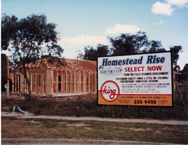 Whitehorse Historical Society Inc.
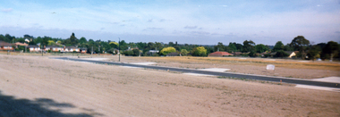
Photograph, Homestead Rise Sub-Division, 1987-88
... Homestead Rise Sub-Division...Coloured photo of Homestead Rise Sub-Division on S.W. corner of Canterbury and Heatherdale Roads....Homestead Rise Sub-Division Photograph Photograph ...Coloured photo of Homestead Rise Sub-Division on S.W. corner of Canterbury and Heatherdale Roads.homestead rise subdivision, canterbury road mitcham, heatherdale road mitcham -
 Warrnambool and District Historical Society Inc.
Documents, Late 20th, early 21st centuries
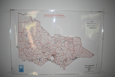
... These ten documents (maps, plans, photographs) mostly come from the Warrnambool City Council and most contain information on sub-divisions and titles of properties in areas around the Central Business District of Warrnambool. ...It has black printing on buff-coloured paper. .9.1 This is a plan of sub-divisions in parts of Crown Allotments 38 & 39 in Warrnambool. ...It has black printing on buff-coloured paper. .9.1 This is a plan of sub-divisions in parts of Crown Allotments 38 & 39 in Warrnambool. ...These ten documents (maps, plans, photographs) mostly come from the Warrnambool City Council and most contain information on sub-divisions and titles of properties in areas around the Central Business District of Warrnambool. The dates range from 1986 to 2006. These maps, plans and photographs are of some interest as they give historical details of subdivisions in Warrnambool and date from the late 20th century. .1 This is a laminated map of the boundaries of Local Governments in Victoria. It is Sheet I of 2 and has red and blue pencil markings and black boundary markings. .2 This is a copy of a plan of a survey in black and white markings on paper. .3 This is a plan of the title details of Section 19 Warrnambool. It has black printing on buff-coloured paper. .4 This is a plan of the allotments in part of the Central Business District of Warrnambool. It is printed in black and white. .5 This is a 2006 coloured aerial photograph of the harbour at Warrnambool – Breakwater etc. .6 This is a 2006 coloured aerial photograph of the Lake Pertobe area in Warrnambool .7 This is a coloured aerial photograph of Warrnambool’s streets over-stamped with road numbers in large blockings. .8 This is a plan showing the title details of Section 11 in Warrnambool. It has black printing on buff-coloured paper. .9.1 This is a plan of sub-divisions in parts of Crown Allotments 38 & 39 in Warrnambool. It has green, pink and yellow markings with black printing. .9.2 This is a plan of the sub-divisions in parts of Allotments 38 & 39 in Warrnambool. It has pink, yellow and blue markings with black printing. It is somewhat faded. warrnambool c.b.d. maps and plans, history of warrnambool -
 Glen Eira Historical Society
Caulfield Subdivision
... Photocopy of sub division plan in Caulfield North of property owned by James Gill, dated 1864...Glen Eira Historical Society 965 Glen Huntly Rd Caulfield VIC 3162 melbourne Caulfield North Land Subdivision Gill James Photocopy of sub division plan in Caulfield North of property owned by James Gill, dated 1864 Caulfield Subdivision ...Photocopy of sub division plan in Caulfield North of property owned by James Gill, dated 1864caulfield north, land subdivision, gill, james -
Port Melbourne Historical & Preservation Society
Plan - Proposed land sub-division, west of railway, Sandridge, 19 Nov 1866
... Proposed land sub-division, west of railway, Sandridge...1866 plan of proposed sub-division of land at Sandridge, west of railway. ...Plan Proposed land sub-division, west of railway, Sandridge Department of Lands and Surveys ...1866 plan of proposed sub-division of land at Sandridge, west of railway. Includes manure depot.J. Noone (Photolithographer, Dept. of Lands and Survey) J. Hardy (Assistant Surveyor)town planning, town planning - proposals shelved, j noone, j hardy -
Whitehorse Historical Society Inc.
Map, Blackburn Heights Estate, 1923
... Auction plans of sub-division for Blackburn heights Estate, 130 sites, 8th December 1923...Springfield Road Blackburn North Surrey Road Blackburn North Gordon Street Blackburn North Koonung Road Blackburn North Harris Street Blackburn North Hirst Street Blackburn North Deane Street Blackburn North Blackburn Heights estate Blackburn North Auction plans of sub-division for Blackburn heights Estate. Auction plans of sub-division for Blackburn heights Estate, 130 sites, 8th December 1923 Blackburn Heights Estate Map Map ...Auction plans of sub-division for Blackburn heights Estate.Auction plans of sub-division for Blackburn heights Estate, 130 sites, 8th December 1923Auction plans of sub-division for Blackburn heights Estate.springfield road blackburn north, surrey road blackburn north, gordon street blackburn north, koonung road blackburn north, harris street blackburn north, hirst street blackburn north, deane street blackburn north, blackburn heights estate, blackburn north -
 Whitehorse Historical Society Inc.
Photograph, Sub-division of the former Mitcham Technical School, 01/01/1998
... Sub-division of the former Mitcham Technical School....Sub-division of the former Mitcham Technical School C.1996. ...Looking towards Carter Avenue, Nunawading. Sub-division of the former Mitcham Technical School. ...Sub-division of the former Mitcham Technical School C.1996. Looking towards Carter Avenue, Nunawading.mitcham technical school, knightsbridge subdivision, nunawading, cherrybrook close, carter avenue -
 Ringwood and District Historical Society
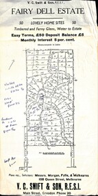
Flyer, Residential Land Sale Sub-division - Fairy Dell Estate, Warranwood, Vic. - circa 1950s
... Residential Land Sale Sub-division - Fairy Dell Estate, Warranwood, Vic. - circa 1950s...Land sale advertisement for 50 home sites with map of Sub-division showing layout of streets and allotments, summary of local features and services and terms of sale, and copy of sectional map of Crown Allotments 20 & 21B Parish of Warrandyte also showing layout of Sub-division....Residential Land Sale Sub-division - Fairy Dell Estate, Warranwood, Vic. - circa 1950s Flyer ...Land sale advertisement for 50 home sites with map of Sub-division showing layout of streets and allotments, summary of local features and services and terms of sale, and copy of sectional map of Crown Allotments 20 & 21B Parish of Warrandyte also showing layout of Sub-division.Subdivision includes Grandview Grove (later Bemboka Road), Merrill Crescent and Kerry Road, Warranwood. Estate Agents - V.C. Swift & Son R.E.S.I., Main Street, Croydon, Phone 20. Solicitors - Morgan, Fyffe & Mulkearns, 108 Queen Street, Melbourne. Handwritten 1970s real estate price notations for some blocks. -
 Whitehorse Historical Society Inc.
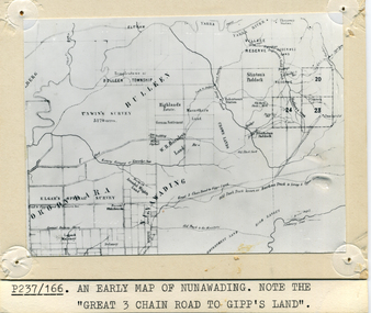
Photograph - B/W Photograph, Map of Nunawading
... Black and white photo of early sub-division of Nunawading.|NOTE:- Great 3 Chain Road to Gipp's Land....Whitehorse Historical Society Inc. 2-10 Deep Creek Road Mitcham melbourne Nunawading Map Black and white photo of early sub-division of Nunawading.|NOTE:- Great 3 Chain Road to Gipp's Land. ...Black and white photo of early sub-division of Nunawading.|NOTE:- Great 3 Chain Road to Gipp's Land.nunawading, map -
Whitehorse Historical Society Inc.
Map, Kylana Estate Tunstall, 1926
... Auctioneer's plan of sub-division of Kylana Estate Tunstall, 8 sites, 2nd Oct 1926. ...Auctioneer: Sergeant & Lehmann Heather Grove Tunstall Kylana estate Springvale Road Tunstall Tunstall Auctioneer's plan of sub-division of Kylana Estate Tunstall. Auctioneer's plan of sub-division of Kylana Estate Tunstall, 8 sites, 2nd Oct 1926. ...Auctioneer's plan of sub-division of Kylana Estate Tunstall.Auctioneer's plan of sub-division of Kylana Estate Tunstall, 8 sites, 2nd Oct 1926. Auctioneer: Sergeant & LehmannAuctioneer's plan of sub-division of Kylana Estate Tunstall.heather grove tunstall, kylana estate, springvale road tunstall, tunstall -
 Phillip Island and District Historical Society Inc.
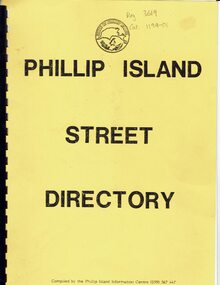
Booklet, Phillip Island Street Directory
... A4 booklet with black clip binding and yellow cover. Includes sub divisional maps, lists of street names and grid numbers....A4 booklet with black clip binding and yellow cover. Includes sub divisional maps, lists of street names and grid numbers. ...The booklet contains a plan of Summerland estate which was compulsorily acquired from 1985 as a nature reserve for the penguins. We assume that the directory was compiled before this date.The directory was compiled by the Information Centre.Beach Street, Cowes is shown on the main map but not listed in the index.HistoricalA4 booklet with black clip binding and yellow cover. Includes sub divisional maps, lists of street names and grid numbers.Phillip Island Street Directory. Shire of Phillip Island logo.summerland estate, street directory, subdivisions, maps -
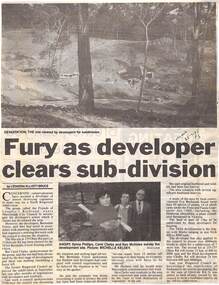 Ringwood and District Historical Society
Newspaper, Scrapbook Clipping, Library Collection, Ringwood, Victoria
... Fury as developer clears sub-division. By Leonora Elliot-Bruce...Fury as developer clears sub-division. By Leonora Elliot-Bruce Scrapbook Clipping, Library Collection, Ringwood, Victoria,. ...Newspaper Clipping from "The Mail", 25-7-95. P3. Fury as developer clears sub-division. By Leonora Elliot-BruceConcerned conservationists have accused a developer of almost destroying vegetation to make way for a North Ringwood subdivision. The group, Friends of Loughie's Bushland, wants Maroondah City Council to investigate the developer's action which it claims has devastated the area. The developers are Barnsdale Forest -
 Bendigo Historical Society Inc.
Document - H.A. & S.R. WILKINSON COLLECTION: CONTRACT OF SALE
... Attached a drawing of the sub-division....Attached a drawing of the sub-division. Document H.A. & S.R. WILKINSON COLLECTION: CONTRACT OF SALE ...This business was owned by father and son, Henry Archibald Wilkinson and Samuel Ronald "Ron" Wilkinson. Henry (1882-1954) was born in Shepparton and died in Bendigo. He was married to Grace Hovendon in 1908. Samuel Ronald "Ron" (1914-1995), Henry's son, was married to Florence Jean McKerlie in 1937.Conditions of sale by private contract dated 26th November, 1937 between Mrs. R.E. Mahon (seller) and N.L. Svanosio (buyer) for land situate in Sternberg Street, Bendigo, being lot 3 on plan of sub-division No. 13862, having a frontage of 60 feet by a depth of 107 feet. Price 40 pounds. Attached a drawing of the sub-division.organization, business, h.a. & s.r wilkinson real estate -
 Glen Eira Historical Society
Railways in Caulfield
... Photograph of Glen Huntly Estate sub division notice including railway gates, Madden estate, St Kilda pier, St Kilda baths...Glen Eira Historical Society 965 Glen Huntly Rd Caulfield VIC 3162 melbourne Glen Huntly Glen Huntly Railway Station Railways Railway Gates Madden estate St Kilda pier St Kilda baths Jetties Swimming Pools Photograph of Glen Huntly Estate sub division notice including railway gates, Madden estate, St Kilda pier, St Kilda baths Railways in Caulfield ...Photograph of Glen Huntly Estate sub division notice including railway gates, Madden estate, St Kilda pier, St Kilda bathsglen huntly, glen huntly railway station, railways, railway gates, madden estate, st kilda pier, st kilda baths, jetties, swimming pools -
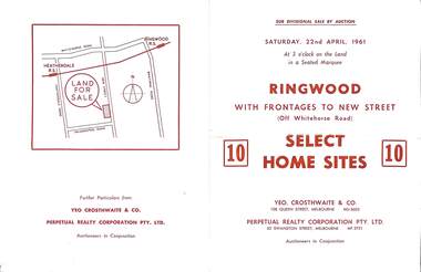 Ringwood and District Historical Society
Flyer, Auction sale brochure advertising home sites with frontages to New Street, Ringwood, Victoria - 1961
... Advertisement for Sub-divisional sale by auction on Saturday, 22nd April, 1961, with terms of sale of 10 home sites with frontages to New Street, Ringwood, Victoria....Advertisement for Sub-divisional sale by auction on Saturday, 22nd April, 1961, with terms of sale of 10 home sites with frontages to New Street, Ringwood, Victoria. ...Advertisement for Sub-divisional sale by auction on Saturday, 22nd April, 1961, with terms of sale of 10 home sites with frontages to New Street, Ringwood, Victoria.Location map showing land for sale on New Street, Ringwood, north of Palmerston Road. Auctioneers in conjunction - Yeo, Crosthwaite & Co., 108 Queen Street Melbourne (Telephone) MU 8605, and Perpetual Realty Corporation Pty. Ltd., 62 Swanston Street, Melbourne (Telephone) MF 3721. -
 Whitehorse Historical Society Inc.
Photograph, Old house in Canterbury Road Blackburn, 1971
... Black and white photo of old house standing well back as a result of Sub-division in Canterbury Road (south side) B/N Blackburn and Springvale Roads, 1971....Whitehorse Historical Society Inc. 2-10 Deep Creek Road Mitcham melbourne canterbury road blackburn Black and white photo of old house standing well back as a result of Sub-division in Canterbury Road (south side) B/N Blackburn and Springvale Roads, 1971. ...Black and white photo of old house standing well back as a result of Sub-division in Canterbury Road (south side) B/N Blackburn and Springvale Roads, 1971.canterbury road, blackburn -
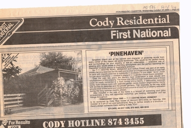 Whitehorse Historical Society Inc.
Newspaper, Pinehaven, 17/10/1990 12:00:00 AM
... Land size 1/2 acre, sub-division potential....Land size 1/2 acre, sub-division potential. Pinehaven Newspaper Newspaper ...Advertisement for auction of 'Pinehaven' built circa 1940, 7 - 11 Centre Road, Vermont (cnr Gallus Close).Advertisement for auction of 'Pinehaven' built circa 1940, 7 - 11 Centre Road, Vermont (cnr Gallus Close). Land size 1/2 acre, sub-division potential.Advertisement for auction of 'Pinehaven' built circa 1940, 7 - 11 Centre Road, Vermont (cnr Gallus Close).pinehaven, centre road, vermont, nos 7-11, poultry, gallus close, cody first national real estate -
Canterbury History Group
Pamphlet - Camberwell Golf Links, c1932 original
... Brochure produced for Land Sub-division sale by auction of Camberwell Golf Links on Saturday 28 May c1932. ...Canterbury History Group 190A Canterbury Road Canterbury melbourne Camberwell Fairmont Avenue Camberwell Road Christowell Street Trams Vintage Cars Brochure produced for Land Sub-division sale by auction of Camberwell Golf Links on Saturday 28 May c1932. ...Brochure produced for Land Sub-division sale by auction of Camberwell Golf Links on Saturday 28 May c1932. Reproduced from the original, includes Map and some historic photographscamberwell, fairmont avenue, camberwell road, christowell street, trams, vintage cars -
 Bendigo Historical Society Inc.
Administrative record - Electoral Roll, 1915
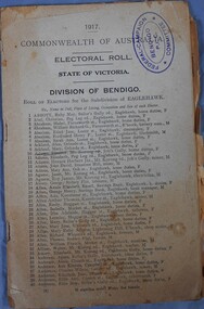
... Roll of electors for the Sub Division of Eaglehawk. Includes Name, Address, Occupation and gender. ...Roll of electors for the Sub Division of Eaglehawk. Includes Name, Address, Occupation and gender. ...Voting registers, or electoral rolls, are a census of those who were eligible to vote. They are valuable because a country-wide census wasn't taken until 1911. Early electoral rolls give an individual’s name, residence, status of property occupation/ownership, and the rate value of the property. Electoral rolls are arranged by electoral district and subdistrict. Electoral rolls were published by each state during election years.Commonwealth of Australia Electoral Roll, State of Victoria, Division of Bendigo, 1917. Roll of electors for the Sub Division of Eaglehawk. Includes Name, Address, Occupation and gender. Assembled and fastened with two large staples.electoral rolls, voting in bendigo -
 Bendigo Historical Society Inc.
Administrative record - Electoral Roll, 1915
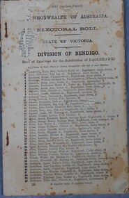
... Roll of electors for the Sub Division of Eaglehawk. Includes Name, Address, Occupation and gender. ...Roll of electors for the Sub Division of Eaglehawk. Includes Name, Address, Occupation and gender. ...Voting registers, or electoral rolls, are a census of those who were eligible to vote. They are valuable because a country-wide census wasn't taken until 1911. Early electoral rolls give an individual’s name, residence, status of property occupation/ownership, and the nature of the rateable property. Electoral rolls are arranged by electoral district and subdistrict. Electoral rolls were published by each state during election years.Commonwealth of Australia Electoral Roll, State of Victoria, Division of Bendigo, 1915 (Second Print). Roll of electors for the Sub Division of Eaglehawk. Includes Name, Address, Occupation and gender. Assembled and fastened with two large staples.electoral rolls, voting in bendigo -
 City of Kingston
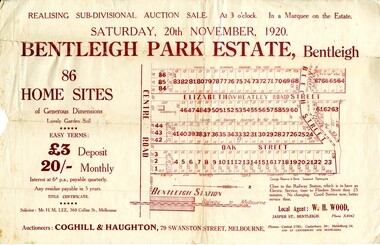
Pamphlet - Colour, W. H. Wood Estate Agent, Realising sub-divisional auction sale Bentleigh Park Estate, Bentleigh, 1920
... Colour pamphlet advertising a realising sub-divisional auction sale of the Bentleigh Park Estate, Bentleigh. ...Incorporates a map of the estate bordered by Centre Road, and including Elizabeth Street (Wheatley Road), Oak Street and Beech Street. Realising sub-divisional auction sale Bentleigh Park Estate, Bentleigh Pamphlet Colour W. ...Sales plan for land in the suburb of Bentleigh, bounded by Centre Road, and incorporating subdivisions on either side of Elizabeth Street (Wheatley Road), Oak Street and Beech Street.The developing urban area of Bentleigh within the City of Kingston. This land sale pamphlet illustrates the subdivision of land within the municipality and the changing demographic of the district as new houses are constructed close to infrastructure.Colour pamphlet advertising a realising sub-divisional auction sale of the Bentleigh Park Estate, Bentleigh. Incorporates a map of the estate bordered by Centre Road, and including Elizabeth Street (Wheatley Road), Oak Street and Beech Street.Hand drawn in grey pencil: a small square on subdivision 33 Hand drawn in grey pencil: a small square incorporating a cross on subdivision 24 Hand written in black ink on reverse: Bentleigh Park / Estate / Ward late Andersonsland sales, estate, bentleigh -
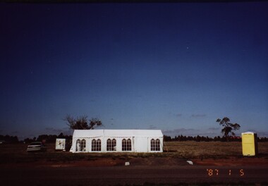 Federation University Historical Collection
Photograph - Colour, Chatham-Holmes Collection: On the road to Burrumbeet, 1987, 1987
... Philip Chatham was responsible for the sub-division located on the road to Burrumbeat. ...Barker Library (top floor) Mount Helen goldfields Philip Chatham was responsible for the sub-division located on the road to Burrumbeat. ...Philip Chatham was responsible for the sub-division located on the road to Burrumbeat. Preparations for land sales.chatham-holmes collection, philip chatham, burrumbeat, land sales