Showing 1298 items matching " survey road"
-
 Kew Historical Society Inc
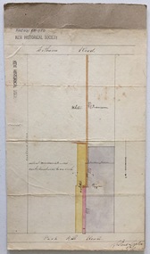
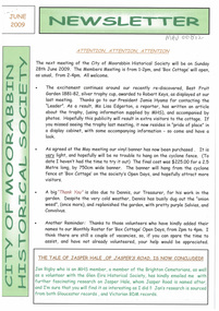
Plan, Survey Plan, Park Hill Road, Kew, 1880-1890
... Survey Plan, Park Hill Road, Kew...road - kew...Holland Loxton -- Surveyor...Survey...The streets identified on the survey plan - Cotham Road, Park Hill Road East, Park Hill Road West in Kew were each gazetted by the Victorian Government in 1865. ...Hand drawn and coloured survey plan created by Holland Loxton, Surveyor and Town Clerk of Kew, showing land owned by Payne in Park Hill Road, Kew. ...Kew Historical Society Inc Kew Court House 188 High Street Kew melbourne The streets identified on the survey plan - Cotham Road, Park Hill Road East, Park Hill Road West in Kew were each gazetted by the Victorian Government in 1865. ...The streets identified on the survey plan - Cotham Road, Park Hill Road East, Park Hill Road West in Kew were each gazetted by the Victorian Government in 1865. The hand-coloured survey plan was completed by Holland Loxton, Town Clerk and Surveyor of the Borough of Kew from 1866. The unnamed survey plan includes names of land owners in addition to measurements (2 chains to 1 inch) and streets. Named owners include Webster, Payne and Francom which will enable us to narrow down the creation date of the survey.Handdrawn survey plan by a former surveyor and town clerk of KewHand drawn and coloured survey plan created by Holland Loxton, Surveyor and Town Clerk of Kew, showing land owned by Payne in Park Hill Road, Kew. The plan includes street names, land measurements and land owners.surveys - kew, maps - kew, holland loxton, park hill road - kew, holland loxton -- surveyor, survey plans -- parkhill road -- kew (vic.) -
 Port Melbourne Historical & Preservation Society
Photograph - J Kitchen & Sons perimeter survey, Williamstown Road and Normanby Road, Dec 2013
... J Kitchen & Sons perimeter survey, Williamstown Road and Normanby Road...surveys. These photos were taken in Dec 2013. Industry - Manufacturing Built Environment - Industrial Business and Traders - Soaps/Candles Demolitions J Kitchen & Sons Pty Ltd Symex Holdings Ltd North Port Oval Port Melbourne Cricket Ground Series 1 of colour photographs taken by Lionel Layfield as he walked around the perimeter of the J Kitchen & Sons Pty Ltd factory site during the early demolition of most of the buildings. .01-.08 - corner of Williamstown Road and Normanby Road to Ingles Street Photograph J Kitchen & Sons perimeter survey, Williamstown Road and Normanby Road ...As the former j Kitchen & Sons site was being cleared, Lionel Layfield, who had worked at the site for many years undertook several pictorial perimeter surveys. These photos were taken in Dec 2013.Series 1 of colour photographs taken by Lionel Layfield as he walked around the perimeter of the J Kitchen & Sons Pty Ltd factory site during the early demolition of most of the buildings. .01-.08 - corner of Williamstown Road and Normanby Road to Ingles Streetindustry - manufacturing, built environment - industrial, business and traders - soaps/candles, demolitions, j kitchen & sons pty ltd, symex holdings ltd, north port oval, port melbourne cricket ground -
 Whitehorse Historical Society Inc.
Map, Survey for road from Doncaster to Ringwood, 01/03/1867
... Survey for road from Doncaster to Ringwood...Survey in County of Bourke, Road Plan no. 390, showing early routes of Doncaster, Whitehorse and Mitcham Roads. ...Surveyor: Thomas E. Rawlinson. Survey for road from Doncaster to Ringwood Map Map ...Survey in County of Bourke, Road Plan no. 390, showing early routes of Doncaster, Whitehorse and Mitcham Roads.Survey in County of Bourke, Road Plan no. 390, showing early routes of Doncaster, Whitehorse and Mitcham Roads. Measurement in chains. Surveyor: Thomas E. Rawlinson.Survey in County of Bourke, Road Plan no. 390, showing early routes of Doncaster, Whitehorse and Mitcham Roads. parish of nunawading, parish of bulleen, whitehorse road mitcham, doncaster road, doncaster east, mitcham road mitcham -
 Emerald Museum & Nobelius Heritage Park
Map - Survey Map - Municipality Road Classification - Beaconsfield-Emerald Rd. (near Downey Rd.) 1972, Title Survey Division, Crown Description - part of Crown Allotments 39A and 39D, Parish of Gembrook, County of Mornington, c1972
... Survey Map - Municipality Road Classification - Beaconsfield-Emerald Rd. ...Title Survey Division/Crown Description/Part of Crown Allotments 39A and 39D, Parish of Gembrook,County of Mornington/Municipality Road Classification - Shire of Berwick, Beaconsfield - Emerald Rd, Upper Beaconsfield - Upper Pakenham Road/John L Dwyer of Fisher Cleeland Turner & Dwyer Pty. ...CLARKE - Principal Title Survey Officer 5.9.72/SP 13072 Image of Crown survey map - changes to allotments bordering Beaconsfield-Emerald Rd. near Downey Rd. in 1972 Title Survey Division, Crown Description - part of Crown Allotments 39A and 39D, Parish of Gembrook, County of Mornington Map Survey Map - Municipality Road Classification - Beaconsfield-Emerald Rd. ...Image of Crown survey map - changes to allotments bordering Beaconsfield-Emerald Rd. near Downey Rd. in 1972Title Survey Division/Crown Description/Part of Crown Allotments 39A and 39D, Parish of Gembrook,County of Mornington/Municipality Road Classification - Shire of Berwick, Beaconsfield - Emerald Rd, Upper Beaconsfield - Upper Pakenham Road/John L Dwyer of Fisher Cleeland Turner & Dwyer Pty. Ltd., 213 King Street, Melbourne - 14 April, 1972/S.R. CLARKE - Principal Title Survey Officer 5.9.72/SP 13072 -
 Rutherglen Historical Society
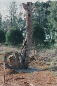
Image, Survey Tree, Jacks Road
... Survey Tree, Jacks Road...survey reference marks...blazed tree...jacks road...Rutherglen Historical Society Murray Street Rutherglen high-country Original blazed survey tree was removed and then replaced by Gas Workers tree survey reference marks blazed tree jacks road Survey marks on tree blaze Colour photograph of the remains of a survey tree, concreted into the ground Survey Tree, Jacks Road Image ...Original blazed survey tree was removed and then replaced by Gas WorkersColour photograph of the remains of a survey tree, concreted into the groundSurvey marks on tree blazetree, survey reference marks, blazed tree, jacks road -
 Rutherglen Historical Society
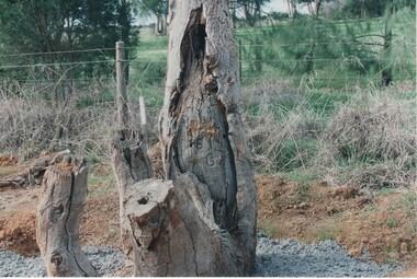
Image, Survey Tree, Jacks Road
... Survey Tree, Jacks Road...survey reference marks...blazed tree...jacks road...This photo is a close-up to better show the survey marks. Survey Tree, Jacks Road Image ...Original blazed survey tree was removed and then replaced by Gas WorkersColour photograph of the remains of a survey tree, concreted into the ground. This photo is a close-up to better show the survey marks.Survey marks on tree blazetree, survey reference marks, blazed tree, jacks road -
University of Melbourne, Burnley Campus Archives
Work on paper (item) - Survey Plan, Thomas and George Licensed Surveyors, Partial Feature Survey Plan 125 Dee Road Millgrove 3799, 25th February, 2014
... Partial Feature Survey Plan 125 Dee Road Millgrove 3799...Road...Millgrove...survey...A sheet of paper on which a partial feature survey plan is depicted for a site at 125 Dee Road, Millgrove. ...Partial Feature Survey Plan 125 Dee Road Millgrove 3799 Work on paper Survey Plan Thomas and George Licensed Surveyors ...Prepared for building and landscape design purposes. It was created by a company called 'Thomas and George Licensed Surveyors' and the survey was conducted on the 24th February 2014. 125 dee road, millgrove, survey plan -
Canterbury History Group
Document - School Project: Elgar's Special Survey, Tudehope, Jennifer, 1963
... ... Survey Road...Maling> J Canterbury Road Survey Road Boroondara Roads Board Camberwell Historical Society Mont Albert Road Brooks> R. ...Well researched essay on the background of Elgar's Special Survey. Includes mapcanterbury, elgar> henry t., land surveys, boroondara, campbell> j & r, dacre> r, towns> r., sea> h., dyce> a., mccarthy> w.g., shenley> james, henty's paddock, norris> j.r., maling> j, canterbury road, survey road, boroondara roads board, camberwell historical society, mont albert road, brooks> r., land subdivisions -
University of Melbourne, Burnley Campus Archives
Document, [Notes on early history of Burnley land], 1857
... Copies of letters re Survey paddock, roads, etc. Refer to paper catalogue...University of Melbourne, Burnley Campus Archives 500 Yarra Boulevard Richmond melbourne burnley survey paddock Copies of letters re Survey paddock, roads, etc. Refer to paper catalogue [Notes on early history of Burnley land] Document ...Copies of letters re Survey paddock, roads, etc. Refer to paper catalogueburnley, survey paddock -
 Eltham District Historical Society Inc
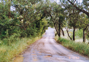
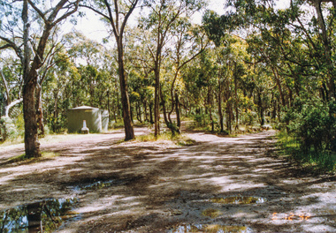
Photograph, Ingrams Road at Allendale Road, 6 December 1992, 06/12/1992
... Road...Eltham Horse Trail (1992 Survey)...Eltham District Historical Society Inc 728 Main Rd Eltham melbourne The Eltham Horse Trail: Research and Warrandyte to Kinglake: Survey of proposed route, December 1992: (1) Research to Kangaroo Ground Allendale Road Eltham Horse Trail (1992 Survey) Ingrams Road Colour photograph Ingrams Road at Allendale Road, 6 December 1992 Photograph ...The Eltham Horse Trail: Research and Warrandyte to Kinglake: Survey of proposed route, December 1992: (1) Research to Kangaroo GroundColour photographallendale road, eltham horse trail (1992 survey), ingrams road -
 Eltham District Historical Society Inc
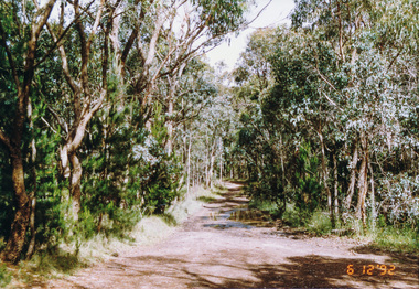
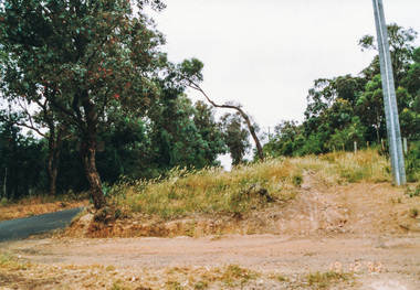
Photograph, Unopened section of Kings Road south from Glenvern Road, Panton Hill, 6 December 1992, 06/12/1992
... survey)...glenvern road...Eltham District Historical Society Inc 728 Main Rd Eltham melbourne The Eltham Horse Trail: Research and Warrandyte to Kinglake: Survey of proposed route, December 1992: (3) Kangaroo Ground to Kinglake eltham horse trail (1992 survey) glenvern road kings road panton hill Colour photograph Unopened section of Kings Road south from Glenvern Road, Panton Hill, 6 December 1992 Photograph ...The Eltham Horse Trail: Research and Warrandyte to Kinglake: Survey of proposed route, December 1992: (3) Kangaroo Ground to KinglakeColour photographeltham horse trail (1992 survey), glenvern road, kings road, panton hill -
 Eltham District Historical Society Inc
Photograph, Track along Glenvern Road, Panton Hill, 6 December 1992, 06/12/1992
... survey)...glenvern road...Eltham District Historical Society Inc 728 Main Rd Eltham melbourne The Eltham Horse Trail: Research and Warrandyte to Kinglake: Survey of proposed route, December 1992: (3) Kangaroo Ground to Kinglake eltham horse trail (1992 survey) glenvern road panton hill Colour photograph Track along Glenvern Road, Panton Hill, 6 December 1992 Photograph ...The Eltham Horse Trail: Research and Warrandyte to Kinglake: Survey of proposed route, December 1992: (3) Kangaroo Ground to KinglakeColour photographeltham horse trail (1992 survey), glenvern road, panton hill -
 Eltham District Historical Society Inc
Photograph, Western end of Mineshaft Road, Smiths Gully, 6 December 1992, 06/12/1992
... survey)...mineshaft road...Eltham District Historical Society Inc 728 Main Rd Eltham melbourne The Eltham Horse Trail: Research and Warrandyte to Kinglake: Survey of proposed route, December 1992: (3) Kangaroo Ground to Kinglake eltham horse trail (1992 survey) mineshaft road smiths gully Colour photograph Western end of Mineshaft Road, Smiths Gully, 6 December 1992 Photograph ...The Eltham Horse Trail: Research and Warrandyte to Kinglake: Survey of proposed route, December 1992: (3) Kangaroo Ground to KinglakeColour photographeltham horse trail (1992 survey), mineshaft road, smiths gully -
 Eltham District Historical Society Inc
Photograph, Mineshaft Road at One Tree Hill Road, Smiths Gully, 6 December 1992, 06/12/1992
... survey)...mineshaft road...Eltham District Historical Society Inc 728 Main Rd Eltham melbourne The Eltham Horse Trail: Research and Warrandyte to Kinglake: Survey of proposed route, December 1992: (3) Kangaroo Ground to Kinglake eltham horse trail (1992 survey) mineshaft road smiths gully one tree hill road Colour photograph Mineshaft Road at One Tree Hill Road, Smiths Gully, 6 December 1992 Photograph ...The Eltham Horse Trail: Research and Warrandyte to Kinglake: Survey of proposed route, December 1992: (3) Kangaroo Ground to KinglakeColour photographeltham horse trail (1992 survey), mineshaft road, smiths gully, one tree hill road -
 Eltham District Historical Society Inc
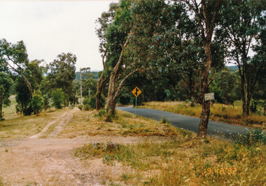
Photograph, Ingrams Road, south from Allendale Road, Research, 19 December 1992, 19/12/1992
... survey)...Allendale Road...Eltham District Historical Society Inc 728 Main Rd Eltham melbourne The Eltham Horse Trail: Research and Warrandyte to Kinglake: Survey of proposed route, December 1992: (4) Connecting trail to Eltham eltham horse trail (1992 survey) Allendale Road Ingrams Road Research (Vic.) ...The Eltham Horse Trail: Research and Warrandyte to Kinglake: Survey of proposed route, December 1992: (4) Connecting trail to ElthamColour photographeltham horse trail (1992 survey), allendale road, ingrams road, research (vic.) -
 Eltham District Historical Society Inc
Photograph, Ingrams Road looking north to Allendale Road, Research, 19 December 1992, 19/12/1992
... survey)...allendale road...Eltham District Historical Society Inc 728 Main Rd Eltham melbourne The Eltham Horse Trail: Research and Warrandyte to Kinglake: Survey of proposed route, December 1992: (4) Connecting trail to Eltham eltham horse trail (1992 survey) allendale road ingrams road research (vic.) ...The Eltham Horse Trail: Research and Warrandyte to Kinglake: Survey of proposed route, December 1992: (4) Connecting trail to ElthamColour photographeltham horse trail (1992 survey), allendale road, ingrams road, research (vic.) -
 Eltham District Historical Society Inc
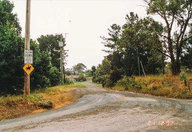
Photograph, Margaret Street from Ingrams Road, Research, 21 December 1992, 21/12/1992
... survey)...ingrams road...Eltham District Historical Society Inc 728 Main Rd Eltham melbourne The Eltham Horse Trail: Research and Warrandyte to Kinglake: Survey of proposed route, December 1992: (4) Connecting trail to Eltham eltham horse trail (1992 survey) ingrams road research (vic.) Margaret Street Colour photograph Margaret Street from Ingrams Road, Research, 21 December 1992 Photograph ...The Eltham Horse Trail: Research and Warrandyte to Kinglake: Survey of proposed route, December 1992: (4) Connecting trail to ElthamColour photographeltham horse trail (1992 survey), ingrams road, research (vic.), margaret street -
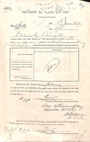 Whitehorse Historical Society Inc.
Document - Report, Section 31 Land Act 1869, 01/06/1872
... survey...whitehorse road...Whitehorse Historical Society Inc. 2-10 Deep Creek Road Mitcham melbourne ainger frank douglas (mounted constable) assistant commissioner of lands and survey whitehorse road mitcham doncaster east road land settlement Land application by Frank Ainger, referred to District Surveyor. ...Land application by Frank Ainger, referred to District Surveyor. Report by Mounted Constable Douglas with description of proposed use of land. Map of area. The area is on the corner of Whitehorse Road and Doncaster East Road.ainger, frank, douglas (mounted constable), assistant commissioner of lands and survey, whitehorse road, mitcham, doncaster east road, land settlement -
Stawell Historical Society Inc
Map, R.O. Robson - Authorised Surveyor, Road from Glenorchy to near Geary's Selection Callawaddy 1880, 29.04.1880
... Survey for Road Creation...Stawell Historical Society Inc 46 Longfield St Stawell grampians Survey for Road Creation Parishes of Richella & Callawadda. ...Survey for Road CreationCloth Backed Map. Plan of Road.Parishes of Richella & Callawadda. County of Borong. Plan of Road. R.O. Robson Authorised Surveyor Stawell 29.04.80 -
Whitehorse Historical Society Inc.
Map, Burwood Road, Box Hill City, 1952
... Country Roads Board survey of Burwood Road, Burwood between Central Avenue and Elgar Road. ...With penciled additions to 1957. Country Roads Board survey of Burwood Road, Burwood between Central Avenue and Elgar Road. ...Country Roads Board survey of Burwood Road, Burwood between Central Avenue and Elgar Road. Includes details of fencing, nature of buildings. With penciled additions to 1957.Country Roads Board survey of Burwood Road, Burwood between Central Avenue and Elgar Road. Includes details of fencing, nature of buildings. With penciled additions to 1957.Country Roads Board survey of Burwood Road, Burwood between Central Avenue and Elgar Road. Includes details of fencing, nature of buildings. With penciled additions to 1957.maps, burwood road, burwood, parer street, elgar road, cromwell street, ireland street, central avenue burwood, scott grove, somers street, gilmour street, evans street, edwards street, mills road -
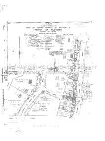 Eltham District Historical Society Inc
Document - Survey Plan, Country Roads Board, SP 6313, Eltham-Yarra Glen Road; Luck St to Henry St, 1956
... Road...Survey Plan...Plan of Survey of Part of Crown Portion 13 Section 4 Parish of Nillumbik, County of Evelyn Eltham-Yarra Glen Road, Shire of Eltham Shows Surveyor field notes, property ownership and building type and construction....Eltham-Yarra Glen Road Country Roads Board Eltham Main Road Survey Plan 1956 A.L. Lyon A.W. Brinkkotter Arthur Street C.R. ...1956 C.R.B. Plan of Survey of Part of Crown Portion 13 Section 4 Parish of Nillumbik, County of Evelyn Eltham-Yarra Glen Road, Shire of Eltham Shows Surveyor field notes, property ownership and building type and construction.eltham-yarra glen road, country roads board, eltham, main road, survey plan, 1956, a.l. lyon, a.w. brinkkotter, arthur street, c.r. burkett, dudley street, e.n. staff, eltham war memorial trust, henry street, luck street, pryor street, the board of land & works, the equity trustees executors and agency coy ltd, the roman catholic trusts corporation, victorian railways commision, neil webster collection -
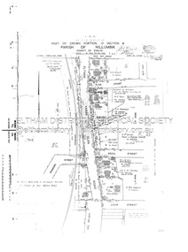 Eltham District Historical Society Inc
Document - Survey Plan, Country Roads Board, SP 6559-6560, Eltham-Yarra Glen Road; Elsa Ct to Luck St, 1957
... Road...Survey Plan...Plan of Survey of Part of Crown Portion 13 Section 4 and Crown Allotment 1 Section 1 Parish of Nillumbik, County of Evelyn Eltham-Yarra Glen Road, Shire of Eltham Shows Surveyor field notes, property ownership and building type and construction....Eltham-Yarra Glen Road Country Roads Board Eltham Main Road Survey Plan 1957 A.M. & A.A. Iowerson A.McG. ...1957 C.R.B. Plan of Survey of Part of Crown Portion 13 Section 4 and Crown Allotment 1 Section 1 Parish of Nillumbik, County of Evelyn Eltham-Yarra Glen Road, Shire of Eltham Shows Surveyor field notes, property ownership and building type and construction.eltham-yarra glen road, country roads board, eltham, main road, survey plan, 1957, a.m. & a.a. iowerson, a.mcg. hepburn, cecil street, coffee lounge, diamond street, e.g. murrell, elsa court, h.b. woodhead, j.c. & s.i. harding, la ronde, luck street, r.m. & v.m. white, r.n. mowatt, the board of land & works, w.g. hains, neil webster collection -
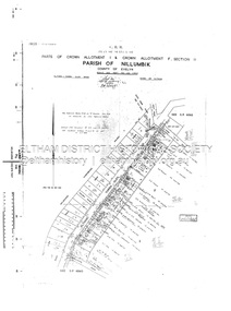 Eltham District Historical Society Inc
Document - Survey Plan, Country Roads Board, SP 6561, Eltham-Yarra Glen Road; Park Rd to Bellevue Rd, 1957
... Road...Survey Plan...Plan of Survey of Parts of Crown Allotment 1 & Crown Allotment F, Section II Parish of Nillumbik, County of Evelyn Eltham-Yarra Glen Road, Shire of Eltham Shows Surveyor field notes, property ownership and building type and construction....Eltham-Yarra Glen Road Country Roads Board Eltham Main Road Survey Plan 1957 A.R. Thomas B. & B.D. Hearn B.G. ...1957 C.R.B. Plan of Survey of Parts of Crown Allotment 1 & Crown Allotment F, Section II Parish of Nillumbik, County of Evelyn Eltham-Yarra Glen Road, Shire of Eltham Shows Surveyor field notes, property ownership and building type and construction.eltham-yarra glen road, country roads board, eltham, main road, survey plan, 1957, a.r. thomas, b. & b.d. hearn, b.g. anderson, bellevue road, e.m. pitts, f.a. m. macrae, g.e. & b. moulder, j. bromley, j.m. & s.g. johnstone, k.f. pitts, l.c. docksey, m. & e.c.w. baart, m.p. bromley, n.r. ord, p.j. & g.e. murphy, park road, r.a. bruce, r.a. macbeth, r.w. shearing, railway road, s.e. & y.p. houghton, w.k. bell, w.s.r. & f.n. toley, neil webster collection -
 City of Moorabbin Historical Society (Operating the Box Cottage Museum)
Newsletter, City of Moorabbin Historical Society June 2009, June 2009
... road ormond...dendy’s special survey 1851...Jasper Hale , transported for theft, earned his ‘Ticket of Leave, and purchased land in Dendy’s Special Survey of 1841 later known as East Bentleigh. city of moorabbin historical society stanley helen rigby jan melbourne moorabbin brighton cheltenham ormond bentleigh market gardeners pioneers early settlers moorabbin shire box cottage museum jasper road ormond dendy’s special survey 1851 north road brighton county of bourke box h. box william parish of moorabbin were jonathan hales jasper port jackson penal colony burgess s. william kemble wiltshire england stonemason bricklayer ‘york’ sailing ship brummell mary st. mary’s catholic church sydney nelson mary ann ‘george hibbert’ sailing ship hale james hale eliza parkes new south wales gold rush ballarat gold rush clunes gold rush forbes nsw gold rush parkes historical society CITY of MOORABBIN HISTORICAL SOCIETY / JUNE 2009 NEWSLETTER 2 x A4 paper printed on 3 sides Issue 12 of the bi-monthly, City of Moorabbin Historical Society Newsletter produced by Society member and Secretary, Mrs Helen Stanley in June 2009. ...The City of Moorabbin Historical Society was formed c 1960 by a group of Moorabbin residents who were concerned that the history of the area should be preserved. A good response to a call for items related to the historical area of Moorabbin Shire brought donations of a wide variety of artefacts which are now preserved by the current members of CMHS at Box Cottage Museum . Helen Stanley, Secretary of CMHS, began producing a Newsletter for members in April 2007 to provide current information and well researched items of historical interest.Helen Stanley has produced a bi-monthly Newsletter, 2007 - 2013, for the members of the City of Moorabbin Historical Society that contains well researched interesting historical items, notification of upcoming events, current advice from Royal Australian Historical Society , Museums Australia Victoria and activities of Local Historical Societies. The Newsletter is an important record of the activities of the CMHS. Jasper Hale , transported for theft, earned his ‘Ticket of Leave, and purchased land in Dendy’s Special Survey of 1841 later known as East Bentleigh. 2 x A4 paper printed on 3 sides Issue 12 of the bi-monthly, City of Moorabbin Historical Society Newsletter produced by Society member and Secretary, Mrs Helen Stanley in June 2009. Notices of the meeting June 28th , an article in ‘The Leader’ newspaper about the Robert Keys ‘Best Fruit Garden 1881 - 82’ Trophy Cup , a large vinyl banner purchased with Grant money, and while acknowledging the Cottage garden volunteer a request for more helpers at Open Days is made. Jan Rigby, CMHS member, has provided research information about Jasper Hale b 1805 in Gloucester, England, transported to NSW 1830, ‘freed man ‘ 1839, purchased land in Dendy’s Special Survey 1844, sold this land 1846 and died 1884 in Parkes NSW. On arrival as a convict in 1830 his occupation is bricklayer and he can ‘ read and write’. CITY of MOORABBIN HISTORICAL SOCIETY / JUNE 2009 NEWSLETTERcity of moorabbin historical society, stanley helen, rigby jan, melbourne, moorabbin, brighton, cheltenham, ormond, bentleigh, market gardeners, pioneers, early settlers, moorabbin shire, box cottage museum, jasper road ormond, dendy’s special survey 1851, north road brighton, county of bourke, box h., box william, parish of moorabbin, were jonathan, hales jasper, port jackson penal colony, burgess s. william, kemble wiltshire england, stonemason, bricklayer, ‘york’ sailing ship, brummell mary, st. mary’s catholic church sydney, nelson mary ann, ‘george hibbert’ sailing ship, hale james, hale eliza, parkes new south wales gold rush, ballarat gold rush, clunes gold rush, forbes nsw gold rush, parkes historical society -
Canterbury History Group
Photograph - Elgar's Special Survey, unknown
... Survey... Canterbury... Canterbury Road...Canterbury History Group 190A Canterbury Road Canterbury melbourne Elgar's Special Survey Canterbury Canterbury Road Riversdale Road Burke Road Prospect Hill Road Wattle Valley Road A photograph of part of Elgar's Special Survey showing owners of property for mostly Canterbury in 1850 Photograph Elgar's Special Survey ...A photograph of part of Elgar's Special Survey showing owners of property for mostly Canterbury in 1850elgar's special survey, canterbury, canterbury road, riversdale road, burke road, prospect hill road, wattle valley road -
 Whitehorse Historical Society Inc.
Letter - Correspondence, Warrandyte, 1/08/1857
... Letter from Survey Office dated 1 August 1857 referring to auriferous indications on each side of Deep Creek revealed in the course of a survey of roads to the Warrandyte Gold Fields....Whitehorse Historical Society Inc. 2-10 Deep Creek Road Mitcham melbourne Warrandyte Goldmining Deep Creek Nunawading Letter from Survey Office dated 1 August 1857 referring to auriferous indications on each side of Deep Creek revealed in the course of a survey of roads to the Warrandyte Gold Fields. ...Letter from Survey Office dated 1 August 1857 referring to auriferous indications on each side of Deep Creek revealed in the course of a survey of roads to the Warrandyte Gold Fields.warrandyte, goldmining, deep creek, nunawading -
 Whitehorse Historical Society Inc.
Document - Correspondence, Anderson's Creek, 19/12/1874
... Bennett Hull to the Surveyor General regarding complaints about the supervision of Mr Hodgkinson, District Surveyor during survey of road to Anderson's Creek....Bennett Hodgkinson Clement Andersons Creek Land Surveys Roads and Streets Letter of resignation, 19 December 1854, from W. ...Letter of resignation, 19 December 1854, from W. Bennett Hull to the Surveyor General regarding complaints about the supervision of Mr Hodgkinson, District Surveyor during survey of road to Anderson's Creek.hull, w. bennett, hodgkinson, clement, andersons creek, land surveys, roads and streets -
 Peterborough History Group
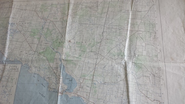
Map - Government map, Government Printer, Port campbell, 1957
... Aerial survey map showing roads, vegetation and other landscape features....Peterborough History Group Peterborough great-ocean-road Aerial survey map showing roads, vegetation and other landscape features. ...Aerial survey map showing roads, vegetation and other landscape features.Significant because it shows the detail of the region in 1957Original 1957 State Aerial Survey Map of Port Campbell region, including Peterboroughpeterborough, aerial survey map, maps, port campell -
Whitehorse Historical Society Inc.
Document, City of Nunawading Heritage Survey Project, 1/10/1994 12:00:00 AM
... Database of places recognised in the field survey. List of buildings, roads etc with indexes by value and by street name....Database of places recognised in the field survey. List of buildings, roads etc with indexes by value and by street name. ...Database of places recognised in the field survey.Database of places recognised in the field survey. List of buildings, roads etc with indexes by value and by street name.Database of places recognised in the field survey. city of nunawading heritage survey, street name -
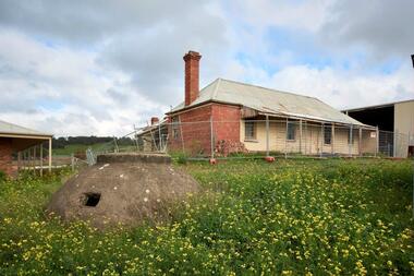 City of Whittlesea
Photograph (item) - Photographs - Buildings, Hin Lim Photography, Blackbraes Farm, 21/6/2017
... Blackbraes Farm is listed in the Whittlesea Heritage Overlay HO14, Photographic survey, 10 Cravens Road Mernda...City of Whittlesea 25 Ferres Boulevard South Morang melbourne Blackbraes Farm is listed in the Whittlesea Heritage Overlay HO14, Photographic survey, 10 Cravens Road Mernda Blackbraes farm Mernda Photographs, Photographic report. ...Blackbraes Farm is listed in the Whittlesea Heritage Overlay HO14, Photographic survey, 10 Cravens Road Merndablackbraes farm, mernda