Showing 4560 items matching " surveyed"
-
 Stawell Historical Society Inc
Map, Easton Johnstone, Map of Stawell Surveyed by Easton Johnstone 1872, 1872
... Map of Stawell Surveyed by Easton Johnstone 1872...Surveyed by Easton Johnstone Contract Surveyor. ...Sloan Street, Skene Street Mines. old Mine Workings Mining Surveyed by Easton Johnstone Contract Surveyor. ...Victoria Co Crushing Machine. St Georges Co Crushing machine. Wimmera Co Crushing Machine. Government Reservoir and Drainage. Sloan Street, Skene Street Mines. old Mine WorkingsA2 map of Stawell Reefs Area. Showing Crushing Machines & Title InfoSurveyed by Easton Johnstone Contract Surveyor. Photo-Lithographed at the Department of Lands & Survey. Melbourne By J Noone 9th May 1872mining -
 Ringwood and District Historical Society
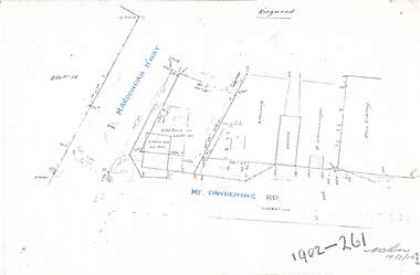
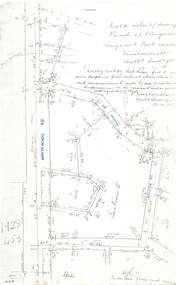
Document - Copy of Lands Department Field Notes - Ringwood, Victoria, Field Notes 1902/261 - Part of O.P. R72D surveyed 14.7.1902
... Field Notes 1902/261 - Part of O.P. R72D surveyed 14.7.1902...Foolscap size photocopies of survey maps with handwritten notations. ...R72D surveyed 14.7.1902 Document Copy of Lands Department Field Notes - Ringwood, Victoria ...Foolscap size photocopies of survey maps with handwritten notations. -
 Ringwood and District Historical Society
Document - Copy of Lands Department Field Notes - Ringwood, Victoria, Field Notes 76631 Surveyed in 1878
... Field Notes 76631 Surveyed in 1878...Foolscap size photocopy of survey map with handwritten notations. References include Canterbury Road, Bungalook Road, Dandenong Creek, Frank Miller, H.K. ...Field Notes 76631 Surveyed in 1878 Document Copy of Lands Department Field Notes - Ringwood, Victoria ...Foolscap size photocopy of survey map with handwritten notations. References include Canterbury Road, Bungalook Road, Dandenong Creek, Frank Miller, H.K. Kemps, Leech. Notations signed and dated January 1878 and May 1879. -
 Stawell Historical Society Inc
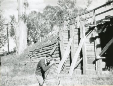
Photograph, Old Wooden Bridge - over the Wimmera River at Joel Joel being surveyed by Allan Rowe for a new bridge 1951
... Old Wooden Bridge - over the Wimmera River at Joel Joel being surveyed by Allan Rowe for a new bridge 1951...Old Wooden Bridge - Joel Joel (Wimmera River) 1951 being surveyed by Allan Rowe for new bridge...Stawell Historical Society Inc 46 Longfield St Stawell grampians Old Wooden Bridge - Joel Joel (Wimmera River) 1951 being surveyed by Allan Rowe for new bridge Stawell Shire Old Wooden Bridge - over the Wimmera River at Joel Joel being surveyed by Allan Rowe for a new bridge 1951 Photograph ...Old Wooden Bridge - Joel Joel (Wimmera River) 1951 being surveyed by Allan Rowe for new bridgestawell shire -
 Ringwood and District Historical Society
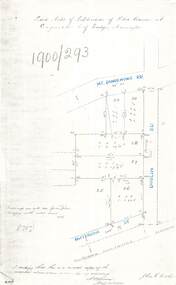
Document - Copy of Lands Department Field Notes - Subdivision of Police Reserve at Ringwood, County of Mornington, Field Notes 1900/293 - Part of O.P. R72C surveyed 1900
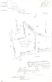
... Field Notes 1900/293 - Part of O.P. R72C surveyed 1900...Foolscap size photocopy of survey map with handwritten notations. References include Mount Dandenong Road, Dublin Road, Patterson Street, Melbourne to Lilydale railway line, I certify that this is a correct copy of recorded observations made by my assistant (signed) W. ...Field Notes 1900/293 - Part of O.P. R72C surveyed 1900 Document Copy of Lands Department Field Notes - Subdivision of Police Reserve at Ringwood, County of Mornington ...Foolscap size photocopy of survey map with handwritten notations. References include Mount Dandenong Road, Dublin Road, Patterson Street, Melbourne to Lilydale railway line, I certify that this is a correct copy of recorded observations made by my assistant (signed) W. Thorn, Staff Surveyor. -
 Ringwood and District Historical Society
Document - Copy of Lands Department Field Notes - Parish of Ringwood, Victoria, Field Notes 88-9/276 - Part of O.P. R72C surveyed 12.10.1888
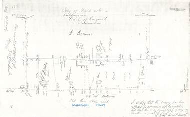
... Field Notes 88-9/276 - Part of O.P. R72C surveyed 12.10.1888...Foolscap size photocopy of survey map with handwritten notations. References include - Commencing at bank of creek, Bearing over fence read 134"12', post and rail fence, old round post, Quigley, WB house iron roof, paling & shingle roof, garden, Forshaw formerly Hoare, D Brown, stable & shed, slats & palings, orchard, Occupied by Forshaw, 4 rooms WB Cottage iron roof, Sherbin, Old three chain road, Maroondah Highway, Molloy's corner, I certify that this survey has been effected in accordance with the regulations and that this is a correct copy of my results (signed) - Reed, Assistant Surveyor, 12.10.88....Field Notes 88-9/276 - Part of O.P. R72C surveyed 12.10.1888 Document Copy of Lands Department Field Notes - Parish of Ringwood, Victoria ...Foolscap size photocopy of survey map with handwritten notations. References include - Commencing at bank of creek, Bearing over fence read 134"12', post and rail fence, old round post, Quigley, WB house iron roof, paling & shingle roof, garden, Forshaw formerly Hoare, D Brown, stable & shed, slats & palings, orchard, Occupied by Forshaw, 4 rooms WB Cottage iron roof, Sherbin, Old three chain road, Maroondah Highway, Molloy's corner, I certify that this survey has been effected in accordance with the regulations and that this is a correct copy of my results (signed) - Reed, Assistant Surveyor, 12.10.88. -
 Greensborough Historical Society
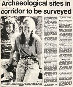
Newspaper - Newspaper Clipping - Digital Image, Diamond Valley News, Archaeological sites in corridor to be surveyed, 1990c
... Archaeological sites in corridor to be surveyed...An undated newspaper article announcing an archaeological survey of the Plenty Valley corridor to be undertaken by Isabel Ellender and Fiona Weaver. ...The findings were published separately by Ellender and Weaver. plenty valley plenty river victoria archaeology victorian archaeological survey isabel ellender fiona weaver Digital copy of newspaper article Archaeological sites in corridor to be surveyed Newspaper Newspaper Clipping - Digital Image Diamond Valley News ...An undated newspaper article announcing an archaeological survey of the Plenty Valley corridor to be undertaken by Isabel Ellender and Fiona Weaver. The findings were published separately by Ellender and Weaver.Digital copy of newspaper articleplenty valley, plenty river, victoria archaeology, victorian archaeological survey, isabel ellender, fiona weaver -
 Ringwood and District Historical Society
Document - Copy of Lands Department Field Notes - Parish of Ringwood, Victoria, Field Notes 1917/137 - Part of O.P. R72 - Allotment 10, surveyed June 1917
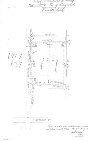
... R72 - Allotment 10, surveyed June 1917...5613b Foolscap size photocopy of survey map with handwritten notations. References include Knight's land, Wantirna Road, Canterbury Road, house, wirenetted, orchard, grass paddock, I certify that these notes are a true copy of observations and measurements taken on the ground by me (signed) H.W. ...R72 - Allotment 10, surveyed June 1917 Document Copy of Lands Department Field Notes - Parish of Ringwood, Victoria ...5613b Foolscap size photocopy of survey map with handwritten notations. References include Knight's land, Wantirna Road, Canterbury Road, house, wirenetted, orchard, grass paddock, I certify that these notes are a true copy of observations and measurements taken on the ground by me (signed) H.W. Moore 5/6/17. -
 Ringwood and District Historical Society
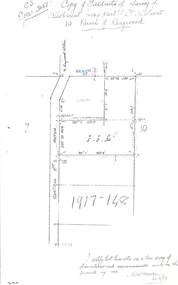
Document - Copy of Lands Department Field Notes - Parish of Ringwood, Victoria, Field Notes 1917/148 - Part of O.P. R72 - Crown Allotment 10, surveyed June 1917
... R72 - Crown Allotment 10, surveyed June 1917...5614b Foolscap size photocopy of survey map with handwritten notations. References include Wantirna Road, to Ringwood Station, Reilly Street, J. ...R72 - Crown Allotment 10, surveyed June 1917 Document Copy of Lands Department Field Notes - Parish of Ringwood, Victoria ...5614b Foolscap size photocopy of survey map with handwritten notations. References include Wantirna Road, to Ringwood Station, Reilly Street, J. Marshall, fence to be erected on boundary, I certify that these notes are a true copy of observations and measurements made on the ground by me (signed) H.W. Moore 22/6/17. -
 Ringwood and District Historical Society
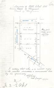
Document - Copy of Lands Department Field Notes - Subdivision of State School Site, Township of Ringwood, Victoria, Field Notes 1903/83 - Part of O.P. R72C Surveyed 13/2/1903
... Field Notes 1903/83 - Part of O.P. R72C Surveyed 13/2/1903...Foolscap size photocopy of survey map with handwritten notations. References include Everard Street, Old Lilydale Road (Maroondah Highway), Dublin Road, poor soil, coarse grass, saplings, I certify that this is a correct copy of the recorded observations & measurements made by me personally (signed) R.J. ...Field Notes 1903/83 - Part of O.P. R72C Surveyed 13/2/1903 Document Copy of Lands Department Field Notes - Subdivision of State School Site, Township of Ringwood, Victoria ...Foolscap size photocopy of survey map with handwritten notations. References include Everard Street, Old Lilydale Road (Maroondah Highway), Dublin Road, poor soil, coarse grass, saplings, I certify that this is a correct copy of the recorded observations & measurements made by me personally (signed) R.J. Gray Autorised Surveyor 13/2/03. -
 Ringwood and District Historical Society
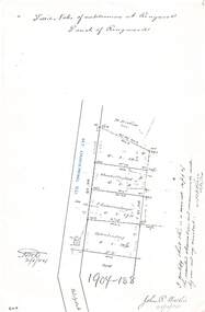
Document - Copy of Lands Department Field Notes - Subdivision of Ringwood, Victoria, Field Notes 1904/188 - Part of O.P. R72D Surveyed 28.4.1904
... Field Notes 1904/188 - Part of O.P. R72D Surveyed 28.4.1904....Foolscap size photocopy of survey map with handwritten notations. References include Mount Dandenong Road to Lilydale, M. ...Thorn 12/5/04 Field Notes 1904/188 - Part of O.P. R72D Surveyed 28.4.1904. Document Copy of Lands Department Field Notes - Subdivision of Ringwood, Victoria ...Foolscap size photocopy of survey map with handwritten notations. References include Mount Dandenong Road to Lilydale, M. Dickson (sold), Church of England, P. Schonnenberger, Helen Lindsay, W.B. iron roof & shingles, I certify that this is a correct copy of the recorded observations and measurement made by me and my assistant (signed) W. Thorn 12/5/04 -
 Ringwood and District Historical Society
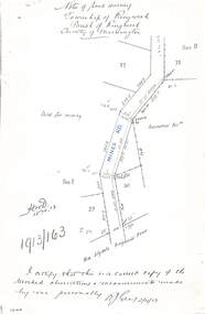
Document - Copy of Lands Department Field Notes - Township of Ringwood, Victoria, Field Notes 1913/163 - Part of O.P. R72D surveyed April 1913
... Field Notes 1913/163 - Part of O.P. R72D surveyed April 1913...5612b Foolscap size photocopy of survey map with handwritten notations. References include Mines Road, New Lilydale Road (Maroondah Highway), (area) Held for mining, Recreation Reserve, Sec D, Sec E, I certify that this is a correct copy of the recorded observations & measurements made by me personally (signed) R.J. ...Field Notes 1913/163 - Part of O.P. R72D surveyed April 1913 Document Copy of Lands Department Field Notes - Township of Ringwood, Victoria ...5612b Foolscap size photocopy of survey map with handwritten notations. References include Mines Road, New Lilydale Road (Maroondah Highway), (area) Held for mining, Recreation Reserve, Sec D, Sec E, I certify that this is a correct copy of the recorded observations & measurements made by me personally (signed) R.J. Gray 2/4/13. -
 Ringwood and District Historical Society
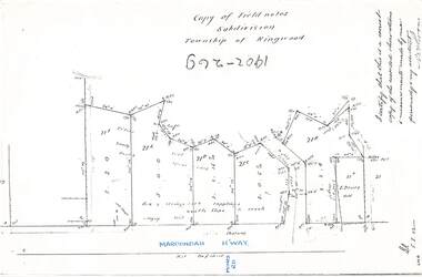
Document - Copy of Lands Department Field Notes - Subdivision Township of Ringwood, Victoria, Field Notes 1902/269 - Part of O.P. R72D surveyed in 1902
... Field Notes 1902/269 - Part of O.P. R72D surveyed in 1902...Foolscap size photocopy of survey map with handwritten notations. References include Maroondah Highway, (opposite) Mines Road, Ti tree, Sandy soil, heath, spear grass, box & stringy bark sapplings, gentle slope to creek, E. ...Field Notes 1902/269 - Part of O.P. R72D surveyed in 1902 Document Copy of Lands Department Field Notes - Subdivision Township of Ringwood, Victoria ...Foolscap size photocopy of survey map with handwritten notations. References include Maroondah Highway, (opposite) Mines Road, Ti tree, Sandy soil, heath, spear grass, box & stringy bark sapplings, gentle slope to creek, E. Drury. I certify that this is a correct copy of the recorded observations and measurements made by me personally and my assistant (signed) W. Thorn. -
 Ringwood and District Historical Society
Document - Copy of Lands Department Field Notes - Parish of Ringwood, Victoria, Field Notes 1909/174 - Part of O.P. R72D surveyed 12.3.1909
... Field Notes 1909/174 - Part of O.P. R72D surveyed 12.3.1909...Foolscap size photocopy of survey map with handwritten notations. References include Mount Dandenong Road, pathway, 2 room house, scillion, shed, WC, 17C sold, Cr lands, orchard, 17E sold, Township boundary, I certify that these field notes are a true copy of the actual results of observations and measurements taken by me on the ground (signed) D. ...Field Notes 1909/174 - Part of O.P. R72D surveyed 12.3.1909 Document Copy of Lands Department Field Notes - Parish of Ringwood, Victoria ...Foolscap size photocopy of survey map with handwritten notations. References include Mount Dandenong Road, pathway, 2 room house, scillion, shed, WC, 17C sold, Cr lands, orchard, 17E sold, Township boundary, I certify that these field notes are a true copy of the actual results of observations and measurements taken by me on the ground (signed) D. Barker 12.3.09. -
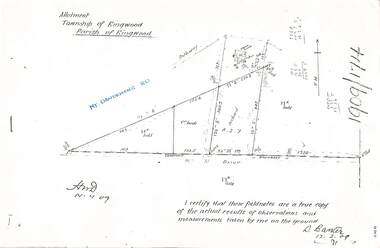
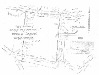 Ringwood and District Historical Society
Document - Copy of Lands Department Field Notes - Parish of Ringwood, Victoria, Field Notes - Part of Crown Allotment 17D Surveyed 1952 (Amended in 1953)
... Field Notes - Part of Crown Allotment 17D Surveyed 1952 (Amended in 1953)....5616b Double foolscap size photocopy of survey map with handwritten notations. References include Corr no. ...Field Notes - Part of Crown Allotment 17D Surveyed 1952 (Amended in 1953). Document Copy of Lands Department Field Notes - Parish of Ringwood, Victoria ...5616b Double foolscap size photocopy of survey map with handwritten notations. References include Corr no. C.93151, Railway Reserve, Station Street, Bedford Road, multiple post & wire fences, multiple galv iron pipes put in, Government Road (Hill Street), Tooronga Road, multiple recent pegs found, Certification 52710 by J. Fitzgerald Licensed Surveyor 17/3/1952. -
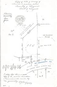 Ringwood and District Historical Society
Document - Copy of Lands Department Field Notes - Survey of Extension to Recreation Reserve, Township of Ringwood, Victoria, Field Notes 1907/436 - Part of O.P. R72D Surveyed 6.8.1907
... Field Notes 1907/436 - Part of O.P. R72D Surveyed 6.8.1907....Foolscap size photocopy of survey map with handwritten notations. References include New Lilydale Road 3 chains wide (Mount Dandenong Road), Silurian, undulating, poor grass, Corner cut off to allow for road in future subdivision, Old recreation reserve, (circled area) oval now in use, A. ...Field Notes 1907/436 - Part of O.P. R72D Surveyed 6.8.1907. Document Copy of Lands Department Field Notes - Survey of Extension to Recreation Reserve, Township of Ringwood, Victoria ...Foolscap size photocopy of survey map with handwritten notations. References include New Lilydale Road 3 chains wide (Mount Dandenong Road), Silurian, undulating, poor grass, Corner cut off to allow for road in future subdivision, Old recreation reserve, (circled area) oval now in use, A. Gisler, I certify that this is a correct copy of the recorded observations & measurements made by me personally (signed) R.J. Gray 6/8/07. -
 Ringwood and District Historical Society
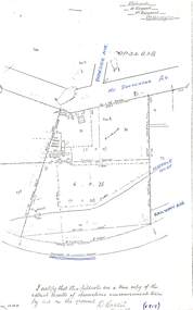
Document - Copy of Lands Department Field Notes - Parish of Ringwood, Victoria, Field Notes - OP34838 - surveyed in 1919 by D. Barker
... Field Notes - OP34838 - surveyed in 1919 by D. Barker....5615b Foolscap size photocopy of survey map with handwritten notations. References include Braeside Avenue, Mount Dandenong Road, Rosedale Court, Railway Avenue, cyclone fence, Sec A, WB house, old tennis court netted, stable, old shed, tank stand, orchard, Township Boundary, netting fence, Railway fence, Ringwood to Lilydale Railway, I certify that these fieldnotes are a true copy of the actual results of observations & measurements taken by me on the ground (signed) D. ...Field Notes - OP34838 - surveyed in 1919 by D. Barker. Document Copy of Lands Department Field Notes - Parish of Ringwood, Victoria ...5615b Foolscap size photocopy of survey map with handwritten notations. References include Braeside Avenue, Mount Dandenong Road, Rosedale Court, Railway Avenue, cyclone fence, Sec A, WB house, old tennis court netted, stable, old shed, tank stand, orchard, Township Boundary, netting fence, Railway fence, Ringwood to Lilydale Railway, I certify that these fieldnotes are a true copy of the actual results of observations & measurements taken by me on the ground (signed) D. Barker (1919). -
 Ringwood and District Historical Society
Document - Copy of Lands Department Field Notes - Parish of Ringwood, Victoria, Field Notes - 1928/453 - Part of OP R72C Surveyed on 17.11.1928
... Field Notes - 1928/453 - Part of OP R72C Surveyed on 17.11.1928....5616b Foolscap size photocopy of survey map with handwritten notations. References include Whitehorse Road, Mines Road, Wilson Street, Rupert Street, New Road (Braeside Avenue), Section E, Allot 31 sold, Allot 32 sold, Recreation Reserve, Allot 25 sold, Allot 29 sold, hedge, spikes, links on line from each corner, I hereby certify that these field notes were prepared from actual observations and measurements made by me or under my supervision on the ground and in accord with regulations (signed) Authorised Surveyor 17/11/28....Field Notes - 1928/453 - Part of OP R72C Surveyed on 17.11.1928. Document Copy of Lands Department Field Notes - Parish of Ringwood, Victoria ...5616b Foolscap size photocopy of survey map with handwritten notations. References include Whitehorse Road, Mines Road, Wilson Street, Rupert Street, New Road (Braeside Avenue), Section E, Allot 31 sold, Allot 32 sold, Recreation Reserve, Allot 25 sold, Allot 29 sold, hedge, spikes, links on line from each corner, I hereby certify that these field notes were prepared from actual observations and measurements made by me or under my supervision on the ground and in accord with regulations (signed) Authorised Surveyor 17/11/28. -
 Rutherglen Historical Society
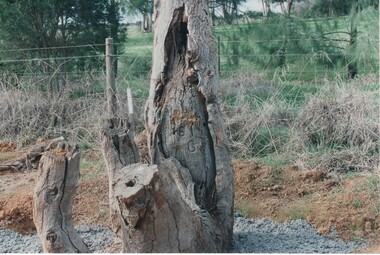
Image, Survey Tree, Jacks Road
... Survey Tree, Jacks Road...Original blazed survey tree was removed and then replaced by Gas Workers...Colour photograph of the remains of a survey tree, concreted into the ground. This photo is a close-up to better show the survey marks....Survey marks on tree blaze...This photo is a close-up to better show the survey marks. Survey Tree, Jacks Road Image ...Original blazed survey tree was removed and then replaced by Gas WorkersColour photograph of the remains of a survey tree, concreted into the ground. This photo is a close-up to better show the survey marks.Survey marks on tree blazetree, survey reference marks, blazed tree, jacks road -
 Rutherglen Historical Society
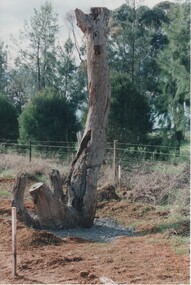
Image, Survey Tree, Jacks Road
... Survey Tree, Jacks Road...Original blazed survey tree was removed and then replaced by Gas Workers...Colour photograph of the remains of a survey tree, concreted into the ground...Survey marks on tree blaze...Rutherglen Historical Society Murray Street Rutherglen high-country Original blazed survey tree was removed and then replaced by Gas Workers tree survey reference marks blazed tree jacks road Survey marks on tree blaze Colour photograph of the remains of a survey tree, concreted into the ground Survey Tree, Jacks Road Image ...Original blazed survey tree was removed and then replaced by Gas WorkersColour photograph of the remains of a survey tree, concreted into the groundSurvey marks on tree blazetree, survey reference marks, blazed tree, jacks road -
 Bendigo Military Museum
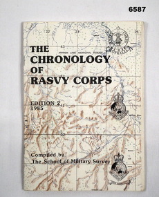
Booklet - The Chronology of the Royal Australian Survey Corps - Ed2 1985, School of Military Survey, Bonegilla, Vic, 24.06.1985
... The Chronology of the Royal Australian Survey Corps - Ed2 1985...This is the second Edition of the "Chrology of the Royal Australian Survey Corps" produced in 1985 by the officers at the School of Military Survey (SMS). ...Cover is a printed map with title and printed versions of the initial Australian Survey Corps Badge, the "King's and Queen's Crown" versions of the Royal Australian Survey Corps badges. ...Compiled and printed by the School of Military Survey...School of Military Survey, Bonegilla, Vic...Royal Australian Survey Corps RASvy Fortuna Army Survey Regiment Army Svy Regt School of Military Survey Compiled and printed by the School of Military Survey A5 paper booklet, 56 x pages and stapled. ...This is the second Edition of the "Chrology of the Royal Australian Survey Corps" produced in 1985 by the officers at the School of Military Survey (SMS). The First Edition produced in 1979 was also produced at the SMS. Since the first edition was produced, a definitive history of the Corps has been published by Brigadier Fitzgerald in his book "Lebanon to Labuan" in 1980 and is the story of the Corps during WWII. This new edition has been completely revised and updated. In order that amendments for future editions may easily be made, this document has compiled on computer. Signed LTCOL JG Corless Commanding Officer SMS. Future and final editions of the History of the Royal Australian Survey Corps have used this document as part of their research.A5 paper booklet, 56 x pages and stapled. Cover is a printed map with title and printed versions of the initial Australian Survey Corps Badge, the "King's and Queen's Crown" versions of the Royal Australian Survey Corps badges. The booklet contains computer text and poor quality B/W photographs.Compiled and printed by the School of Military Surveyroyal australian survey corps, rasvy, fortuna, army survey regiment, army svy regt, school of military survey -
 Bendigo Military Museum
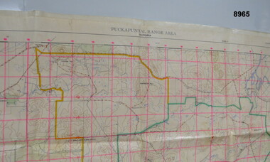
Map - MAP - PUCKAPUNYAL RANGE AREA, Royal Australian Survey Corps, Bendigo, 1958
... Military Survey, First Edition 1958....Large waterproof map of Puckapunyal Range area compiled by the Royal Australian Survey Corps in 1958 detailing Reference locations in and around Puckapunyal area....”Puckapunyal Range Area Military Survey Australia 1.25,000. First Edition”...Royal Australian Survey Corps, Bendigo...Military Survey, First Edition 1958. Passchendaele Barracks Trust PBT? ...Military Survey, First Edition 1958.Large waterproof map of Puckapunyal Range area compiled by the Royal Australian Survey Corps in 1958 detailing Reference locations in and around Puckapunyal area.”Puckapunyal Range Area Military Survey Australia 1.25,000. First Edition”passchendaele barracks trust, pbt?, military map -
 Wodonga & District Historical Society Inc
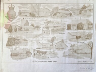
Work on paper - Sketch - The School of Military Survey, Bonegilla
... Sketch - The School of Military Survey, Bonegilla...Shortly afterwards additional huts were acquired by the School of Military Survey, which established field-survey practical training areas and special astronomical observation sites as it began conducting courses in surveying. ...A large poster size representation of the variety of buildings at Bonegilla, Victoria when it served as the location for the Royal Australian School of Military Survey. The insignia of the Royal Australian Survey Corps is featured in the top left hand corner....Top left corner: Insignia of the Royal Australian Survey Corps At bottom of sketches: "The School of Military Survey, Bonegilla Victoria / January 1966 - December 1982...Sketch - The School of Military Survey, Bonegilla Work on paper Sketch - The School of Military Survey, Bonegilla ...Bonegilla operated as an army base from September 1940 and by 1943 was expanded to 848 buildings, including a general hospital. It provided training for small arms instructors, signallers, transport workers, bomb disposal and gas warfare personnel. In a response to the need to house the growing number of displaced persons coming to Australia, the Bonegilla Reception and Training Centre began operating in 1947. For some time it was a shared facility but the Army withdrew temporarily from Bonegilla in 1949, whilst still retaining ownership of the site. From 1949-65 Bonegilla Reception and Training Centre operated without a military presence. However, in the late 1960s and Australia’s commitments to the Vietnam War and pressed by the need to find accommodation to train men, especially National Servicemen, the Army negotiated with the Department of Immigration to take over several blocks at Bonegilla in 1965. Thirty-five huts were acquired by the Royal Australian Army Ordnance Corps as a Recruit Training Centre in which National Servicemen and recruits could attend 10-week ordnance courses. Shortly afterwards additional huts were acquired by the School of Military Survey, which established field-survey practical training areas and special astronomical observation sites as it began conducting courses in surveying. Instructors and trainees co-located at Bonegilla with migrant reception centre. In 1971 the Reception Centre closed and the site reverted to the Army. Progressively after 1971 the Army undertook a major site redevelopment with the construction of Latchford Barracks as the Army Apprentice School. Later Latchford Barracks was redeveloped into part of the Army Logistic Training Centre. Block 19 of the Mirant Reception Centre later became the Bonegilla Migrant Experience Heritage Park.This item depicts a heritage listed historical site located in the Wodonga district.A large poster size representation of the variety of buildings at Bonegilla, Victoria when it served as the location for the Royal Australian School of Military Survey. The insignia of the Royal Australian Survey Corps is featured in the top left hand corner.Top left corner: Insignia of the Royal Australian Survey Corps At bottom of sketches: "The School of Military Survey, Bonegilla Victoria / January 1966 - December 1982migrant reception centre bonegilla, army at bonegilla, australian military -
 Bendigo Military Museum
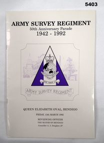
Booklet - Army Survey Regiment 50th Anniversary Parade Souvenir, Army Survey Regiment, Bendigo, 1992
... Army Survey Regiment 50th Anniversary Parade Souvenir...Original program of the 50th Anniversary parade for the Army Survey Regiment 1992 held at the Queen Elizabet Oval Bendigo....Cream covered Booklet with Title and Army Survey Regiment Logo printed in black and purple on the cover....“Army Survey Regiment 50th Anniversary Parade 1942-1992 Insignia- Army Survey Corps."...Army Survey Regiment, Bendigo...Souvenir Army Survey Regiment Army Svy Regt Fortuna Royal Australian Survey Corps RASvy “Army Survey Regiment 50th Anniversary Parade 1942-1992 Insignia- Army Survey Corps." ...Original program of the 50th Anniversary parade for the Army Survey Regiment 1992 held at the Queen Elizabet Oval Bendigo.Cream covered Booklet with Title and Army Survey Regiment Logo printed in black and purple on the cover.“Army Survey Regiment 50th Anniversary Parade 1942-1992 Insignia- Army Survey Corps."Videre Parare Est" Queen Elizabeth Oval, Bendigo. Friday 13 March 1992 Reviewing officer, The Mayor of Bendigo, Councillor A. J. Douglass JPsouvenir, army survey regiment, army svy regt, fortuna, royal australian survey corps, rasvy -
 Bendigo Military Museum
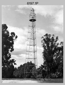
Photograph - Royal Australian Survey Corps Survey Observation Towers, c1950s
... Royal Australian Survey Corps Survey Observation Towers...This is a set of seven photographs of Royal Australian Survey Corps surveyors setting up observation towers in the field and undertaking survey observations during mapping and geodetic control operations. c1950s. ...This is a set of seven photographs of Royal Australian Survey Corps surveyors setting up observation towers in the field and undertaking survey observations during mapping and geodetic control operations. c1950s. ....1P with paper tag annotated ‘Bilby Tower’ .4P on back – ‘Bilby Tower’. .5P on back – ‘Survey Observing Tower. Observing tower used for angular measurement in flat country. 75’ high – CAPT Ricketts climbing. .6P, .7P on back. ‘1960s?’...Army Survey Regiment...Royal Australian Survey Corps Survey Observation Towers Photograph Royal Australian Survey Corps Survey Observation Towers Army Survey Regiment ...This is a set of seven photographs of Royal Australian Survey Corps surveyors setting up observation towers in the field and undertaking survey observations during mapping and geodetic control operations. c1950s. Survey observation towers were used mainly to take angular measurements in flat or heavily forested terrain, where height was necessary to achieve observer’s line-of-sight between field survey station. The Bilby Tower seen in photo .5P was erected to a height of 75 feet (23m) above ground level. The use of the Bilby Tower in Topographic Squadron’s field survey operations from 1955 to 1966 is described in page 54 of Valerie Lovejoy’s book 'Mapmakers of Fortuna – A history of the Army Survey Regiment’ ISBN: 0-646-42120-4. CAPT George Ricketts’ period of service was from 1942 to 1976 reaching the rank of LTCOL. It is noted in page 35 of Valerie Lovejoy’s book that then SGT Ricketts hand lettering skills came to the fore from his contribution to the draughting of one of the Japan’s Instruments of Surrender in 1945.This is a set of seven photographs of Royal Australian Survey Corps surveyors setting up observation towers in the field and undertaking survey observations during mapping and geodetic control operations. c1950s. The photographs were printed on photographic paper and are part of the Army Survey Regiment’s Collection. The photographs were scanned at 300 dpi. .1) - Photo, black & white, c1950s, ‘Bilby’ survey observation tower. .2) - Photo, black & white, c1950s, CAPT George Ricketts climbing ‘Bilby’ survey observation tower. .3) - Photo, black & white, c1950s, geodetic survey equipment on ‘Bilby’ survey observation tower. .4) - Photo, black & white, c1950s, two unidentified field surveyors on ‘Bilby’ survey observation tower. .5) - Photo, black & white, c1950s, two unidentified field surveyors, with CAPT Ricketts climbing ‘Bilby’ survey observation tower. .6) - Photo, black & white, c1950s, two unidentified field surveyors undertaking observations on survey observation tower. .7) - Photo, black & white, c1950, two unidentified field surveyors erecting or dismantling a survey observation tower..1P with paper tag annotated ‘Bilby Tower’ .4P on back – ‘Bilby Tower’. .5P on back – ‘Survey Observing Tower. Observing tower used for angular measurement in flat country. 75’ high – CAPT Ricketts climbing. .6P, .7P on back. ‘1960s?’royal australian survey corps, rasvy, army survey regiment, army svy regt, fortuna, asr, surveying -
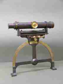 Federation University Historical Collection
Instrument - Scientific Equipment, Miner's Dial, c1893 - 1901
... Used for surveying classes at the Ballarat School of Mines. ...A surveying instrument consisting of theodolite with single crosshair(.1) mountable on a magnetic compass (.2), designed to sit inside a polished wood carry box. ...On suppliers label: "Instrument maker to the surveying and engineering departments of her Majesty's Government of South Australia"...Used for surveying classes at the Ballarat School of Mines. ...Used for surveying classes at the Ballarat School of Mines. Purchased/acquired during Queen Victoria's reign. The 1893 Ballarat School of Mines Calendar states that mine surveying instruments "always at the disposal of the students" including "one miner's dial".A surveying instrument consisting of theodolite with single crosshair(.1) mountable on a magnetic compass (.2), designed to sit inside a polished wood carry box. Serial Number 4470On suppliers label: "Instrument maker to the surveying and engineering departments of her Majesty's Government of South Australia"ballarat school of mines, surveying, scientific instruments, scientific objects, otto boettger, optician, miner's dial -
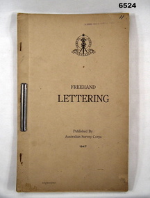 Bendigo Military Museum
Pamphlet - Australian Survey Corps - Freehand Lettering Pamphlet 1947, Australian Survey Corps, Balcombe, 1947
... Australian Survey Corps - Freehand Lettering Pamphlet 1947...All members of the Australian Survey Corps, that was later renamed the Royal Australian Survey Corps were expected to be proficient at freehand lettering and figuring. ...Cover has Australian Survey Corps Theodolite Badge in black and white above the Title "Freehand Lettering Published By Australian Survey Corps 1947....Has a stamp " E COMD FIELD SURVEY Unit"...Australian Survey Corps, Balcombe...Royal Australian Survey Corps RASvy Fortuna Army Survey Regiment Army Svy Regt ASR School of Military Survey SMS Balcombe Hand-written No"11" in top RH corner. ...All members of the Australian Survey Corps, that was later renamed the Royal Australian Survey Corps were expected to be proficient at freehand lettering and figuring. Initially all text on military maps was hand lettered in ink and an extremely high level of proficiency was required. Later technology changes meant that there was less reliance on hand lettering. This 17 x foolscap sized page booklet with light buff coloured cardboard covers held together with an ARNOS fastener was used to teach members of the Australian Survey Corps how to Hand Letter in 1947. Example practice lettering style work sheets are included at the rear of the document.17 x foolscap sized pages with light buff coloured cardboard covers held together with an ARNOS fastener. Example lettering style work sheets at the rear of the document. Cover has Australian Survey Corps Theodolite Badge in black and white above the Title "Freehand Lettering Published By Australian Survey Corps 1947.Hand-written No"11" in top RH corner. Has a stamp " E COMD FIELD SURVEY Unit"royal australian survey corps, rasvy, fortuna, army survey regiment, army svy regt, asr, school of military survey, sms, balcombe -
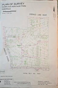 Emerald Museum & Nobelius Heritage Park
Map - Plan of Survey - Nobelius Heritage Park 2013, L. Nobelius, Nobelius Heritage Park, Plan of Survey 2013, c2013
... Nobelius Heritage Park, Plan of Survey 2013...Survey map printed by L. Nobelius...Image of Plan of Survey of Nobelius Heritage Park, Emerald...Topographical map of Nobelius Heritage Park/Denotes tree positions/Scale 1:1000 (A3)/drawn by L.NOBELIUS 20/3/2013/Survey Ref Number 5884/Nobelius Land Surveyors, PO Box 461, Pakenham 3810, Ph 03 9541 4112...Emerald Museum & Nobelius Heritage Park 5 Crichton Rd Emerald yarra-valley-and-the-dandenong-ranges Survey map printed by L. Nobelius Historical connection between surveyor and the park's creator Topographical map of Nobelius Heritage Park/Denotes tree positions/Scale 1:1000 (A3)/drawn by L.NOBELIUS 20/3/2013/Survey Ref Number 5884/Nobelius Land Surveyors, PO Box 461, Pakenham 3810, Ph 03 9541 4112 Image of Plan of Survey of Nobelius Heritage Park, Emerald Nobelius Heritage Park, Plan of Survey 2013 Map Plan of Survey - Nobelius Heritage Park 2013 L. ...Survey map printed by L. NobeliusHistorical connection between surveyor and the park's creatorImage of Plan of Survey of Nobelius Heritage Park, EmeraldTopographical map of Nobelius Heritage Park/Denotes tree positions/Scale 1:1000 (A3)/drawn by L.NOBELIUS 20/3/2013/Survey Ref Number 5884/Nobelius Land Surveyors, PO Box 461, Pakenham 3810, Ph 03 9541 4112 -
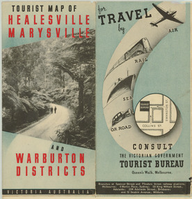 Marysville & District Historical Society
Map (Item) - Tourist Map, Department of Lands & Survey, Tourist Map of Healesville, Marysville and Warburton Districts, 1938
... A tourist map for Healesville, Marysville and Warburton that was produced by the Victorian Department of Crown Lands and Survey, in conjunction with Victorian Railways, in 1938....A tourist map for Healesville, Marysville and Warburton that was produced by the Victorian Department of Crown Lands and Survey, in conjunction with Victorian Railways, in 1938....Compiled by the Department of Lands and Survey, Melbourne Issued by the Betterment and Publicity Board, Victorian Railways, Melbourne, Victoria. ...Department of Lands & Survey...Tourist Map of Healesville, Marysville and Warburton Districts Map Tourist Map Department of Lands & Survey Victorian Railways ...A tourist map for Healesville, Marysville and Warburton that was produced by the Victorian Department of Crown Lands and Survey, in conjunction with Victorian Railways, in 1938.A tourist map for Healesville, Marysville and Warburton that was produced by the Victorian Department of Crown Lands and Survey, in conjunction with Victorian Railways, in 1938.Compiled by the Department of Lands and Survey, Melbourne Issued by the Betterment and Publicity Board, Victorian Railways, Melbourne, Victoria. May 1938healesville, marysville, warburton, victoria, tourist information, tourism, map, tourist map, victorian deparment of crown lands and survey, victorian railways, betterment and publicity board -
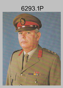 Bendigo Military Museum
Photograph - Director of the Royal Australian Survey Corps COL Don Swiney MBE, Russell, Canberra, c1988
... Director of the Royal Australian Survey Corps COL Don Swiney MBE, Russell, Canberra. ...LTCOL Don Swiney MBE was appointed as CO of the Army Survey Regiment from 1985 to 1987. He was subsequently promoted to Colonel and was Director of the Royal Australian Survey Corp from November 1988 to January 1991, and the honorary position as Colonel Commandant from January 1993 to January 1996. ...The colour and black and white photographs were printed on photographic paper and are part of the Army Survey Regiment’s Collection. The photographs were scanned at 300 dpi. .1) - Photo, colour, c1988, Director of the Royal Australian Survey Corps COL Don Swiney MBE. .2) - Photo, black & white, c1988, Director of the Royal Australian Survey Corps COL Don Swiney MBE.....1P – on top surround ‘The Director’, on bottom surround ‘Director Royal Australian Survey Corps COL DG Swiney MBE.’...Army Survey Regiment...Army Survey Regiment ...These two formal photos of COL Don Swiney MBE were taken in Russell Offices, Canberra circa 1988. LTCOL Don Swiney MBE was appointed as CO of the Army Survey Regiment from 1985 to 1987. He was subsequently promoted to Colonel and was Director of the Royal Australian Survey Corp from November 1988 to January 1991, and the honorary position as Colonel Commandant from January 1993 to January 1996. These two formal photos of COL Don Swiney MBE were taken in Russell Offices, Canberra circa 1988. The colour and black and white photographs were printed on photographic paper and are part of the Army Survey Regiment’s Collection. The photographs were scanned at 300 dpi. .1) - Photo, colour, c1988, Director of the Royal Australian Survey Corps COL Don Swiney MBE. .2) - Photo, black & white, c1988, Director of the Royal Australian Survey Corps COL Don Swiney MBE..1P – on top surround ‘The Director’, on bottom surround ‘Director Royal Australian Survey Corps COL DG Swiney MBE.’royal australian survey corps, rasvy, army survey regiment, army svy regt, fortuna, asr