Showing 12 items matching " urban planners"
-
 Lakes Entrance Historical Society
Map - Figure 2.3 Lakes Entrance Commercial Strategy-Shire of Tambo Strategy Plan, Tract Consultants Pty Ltd Landscape Architects and Urban Planners
... Tract Consultants Pty Ltd Landscape Architects and Urban Planners...Islands Waterways Roads Landowners Shows roads and landowners, Bulloch Island, Cunninghame Arm, Ninety Mile Beach Map Figure 2.3 Lakes Entrance Commercial Strategy-Shire of Tambo Strategy Plan Tract Consultants Pty Ltd Landscape Architects and Urban Planners ...Shows roads and landowners, Bulloch Island, Cunninghame Arm, Ninety Mile Beachislands, waterways, roads, landowners -
Lakes Entrance Historical Society
Map - Figure 2.4 Sketch Plan Lakes Entrance, Tract Consultants Pty Ltd Landscape Architects and Urban Planners, Feb. 1986
... Tract Consultants Pty Ltd Landscape Architects and Urban Planners...Car Park Roads and Streets Foreshore Development Sketch plan Lakes Entrance Long Term Treatment Car Park and Foreshore Esplanade Development for Shire of Tambo Map Figure 2.4 Sketch Plan Lakes Entrance Tract Consultants Pty Ltd Landscape Architects and Urban Planners ...Sketch plan Lakes Entrance Long Term Treatment Car Park and Foreshore Esplanade Development for Shire of Tambocar park, roads and streets, foreshore, development -
 Robin Boyd Foundation
Document - Manuscript, Robin Boyd, Something Wrong with our Cities
... ... urban planners...A possible future the city containing entertainment and culture, with the suburbs having open space and gardens but with access to city life. city cities suburbs melbourne Sydney American cities European cities urban planners Robin Boyd manuscript Typewritten (c copy), quarto, 3 pages Something Wrong with our Cities Document Manuscript Robin Boyd ...Makes comparisons between Australian cities and American and European cities. Melbourne and Sydney are heading in the same direction as Los Angeles. A possible future the city containing entertainment and culture, with the suburbs having open space and gardens but with access to city life.Typewritten (c copy), quarto, 3 pagescity, cities, suburbs, melbourne, sydney, american cities, european cities, urban planners, robin boyd, manuscript -
 Robin Boyd Foundation
Journal, Peter Bellew, Art in Australia, Jun, Jul, Aug 1942
... Walter Bunning was a prominent Australian architect and urban planner - a contemporary of Robin Boyd....Walter Bunning was a prominent Australian architect and urban planner - a contemporary of Robin Boyd. Walter Bunning Rachel Forster Hospital World War 2 Walsh St library Art in Australia Journal Peter Bellew Sydney Morning Herald ...Includes 2 articles by Walter Bunning - "Aesthetics and War" p.71, "Rachel Forster Hospital" p.85. Walter Bunning was a prominent Australian architect and urban planner - a contemporary of Robin Boyd.walter bunning, rachel forster hospital, world war 2, walsh st library -
 Glen Eira Historical Society
Document - NEERIM ROAD RAILWAY CROSSING AND GATES GLEN HUNTLY
... Document details the proposed VicRail improvement and four alternative improvements as we as a blank questionnaire for the submission of ideas regarding the proposals to the Caulfield City Council Urban Planner. A short summary of other concerns held by two councillors and an engineer regarding the proposal is also included, as is a Railway Noise Level. ...Document details the proposed VicRail improvement and four alternative improvements as we as a blank questionnaire for the submission of ideas regarding the proposals to the Caulfield City Council Urban Planner. A short summary of other concerns held by two councillors and an engineer regarding the proposal is also included, as is a Railway Noise Level. ...This file contains two items: 1/Twelve photographs of the Glen Huntly, Neerim Road hand-operated railway gates, dated 1983 and November 1985, photographer unknown, and two black and white copies of two of the original photographs. Four photographs are in black and white and eight are in colour, all picturing the Gatekeeper’s shelter and/or the railway gates. Six photographs dated 1985 include the Gatekeeper, unidentified, in some photos operating the gates. 2/A three-page pamphlet dated 03/05/1979 promoting a public meeting at the Caulfield Town Hall to debate Road Grade Separation proposals for the Neerim Road and Glenhuntly Road railway crossings. Document details the proposed VicRail improvement and four alternative improvements as we as a blank questionnaire for the submission of ideas regarding the proposals to the Caulfield City Council Urban Planner. A short summary of other concerns held by two councillors and an engineer regarding the proposal is also included, as is a Railway Noise Level. Railway Pamphlet also includes a map of the area surrounding the railway crossings under discussion 1977.glenhuntly road, neerim road, caulfield, railway gates, gates, hand-operated railway gates, railways, roads and streets, railway crossings, architectural features, town halls, official buildings, vicrail, meetings, public meetings, caulfield town hall, gatekeepers, caulfield city council, elsternwick, glen huntly, caulfield park, caulfield racecourse, normanby road, dandenong road, railway buildings, railway stations, land transport, transport establishments, hordern a.g., dunstan don, hordern bill, needham j.g., advertisements, graphics, advertising, advertising signs, signs, estate agents, business people, stockdale and leggo, buildings structures and establishments, occupations, united signs, signs, communication devices, motor vehicles, glenhuntly railway station, town planning, civic and landscape art, engineers, professionals, traffic, road transport, transport, maps, documents, plans -
 Federation University Art Collection
Work on paper - Printmaking - Lithograph (Limited Edition), Le Corbusier, 'Modulor' by Le Corbusier, 1956, 1956
... Le Corbusier (or Charles-Édouard Jeanneret-Gris) (6 October 6, 1887 – August 27, 1965) Born Chaux-de-Fonds, Switzerland Studied at the local art school Began to study architecture in 1905 With Amedee Ozenfant founded the journal “L’Esprit Nouveau” in 1920 Became a French citizen in 1930 La Corbusier was a Swiss-French architect, designer, painter, urban planner, writer, and one of the pioneers of what is now called modern architecture. ...Federation University Art Collection Artworks are displayed at Federation University Australia campuses at Ballarat, Gippsland (Churchill), Stawell and Horsham. goldfields Le Corbusier (or Charles-Édouard Jeanneret-Gris) (6 October 6, 1887 – August 27, 1965) Born Chaux-de-Fonds, Switzerland Studied at the local art school Began to study architecture in 1905 With Amedee Ozenfant founded the journal “L’Esprit Nouveau” in 1920 Became a French citizen in 1930 La Corbusier was a Swiss-French architect, designer, painter, urban planner, writer, and one of the pioneers of what is now called modern architecture. ...Le Corbusier (or Charles-Édouard Jeanneret-Gris) (6 October 6, 1887 – August 27, 1965) Born Chaux-de-Fonds, Switzerland Studied at the local art school Began to study architecture in 1905 With Amedee Ozenfant founded the journal “L’Esprit Nouveau” in 1920 Became a French citizen in 1930 La Corbusier was a Swiss-French architect, designer, painter, urban planner, writer, and one of the pioneers of what is now called modern architecture. He was born in Switzerland and became a French citizen in 1930. His career spanned five decades, with his buildings constructed throughout Europe, India, and the Americas. (Wikipedia) The Modulor is an anthropometric scale of proportions devised by the Swiss-born French architect Le Corbusier (1887–1965). It was developed as a visual bridge between two incompatible scales, the imperial and the metric system. It is based on the height of a man with his arm raised. It was used as a system to set out a number of Le Corbusier's buildings and was later codified into two books. (wikipedia) This item is part of the Federation University Art Collection. The Art Collection features over 1000 works and was listed as a 'Ballarat Treasure' in 2007.Limited edition lithograph after an original collage by Le Corbusier, probably executed in Mourlot Workshop. art, artwork, le corbusier, modular, mourlot workshop, lithograph, colour lithograph, printmaking, aavailable -
 Glen Eira Historical Society
Article - MONASH UNIVERSITY CAULFIELD CAMPUS
... Altoon and Porter (Master Planner and Urban Designer )...NHArchitecture Altoon and Porter (Master Planner and Urban Designer ) Huczek Wojciech (Architect) Lipsys Andrius (Photographer) Martens Karel Station Square Development Campus Map Derby Lane Princess Lane Post Office Place Caulfield Station Sir John Monash Drive Derby Road The Hub The Mat Post Office Square Station Square Zagame’s Hotel Dandenong Road OASE 33 Art and Design Building Monash University Caulfield Campus Caulfield East Universities Tertiary Education Article MONASH UNIVERSITY CAULFIELD CAMPUS ...This folder contains 6 items about this educational institution: 1/Undated colour slides showing various angles of two different building facades of Monash Caulfield Campus. 2/Article 'Martens Matters' re launch of exhibition of covesr of OASE 33 Magazine by Designer Karel Martens. Date noted as 01/04/2011 in 'The Age'. 3/Collection of 6 separate cards, all Priority Development Panel Submissions, Design Visualization, dated May 2006 (Architectural drafts) dated 31/03/2006 plus 2 identical cards dated 01/05/2006 - all drawings and one plan for NHArchitecture. 4/Collection of 4 colour separate cards, all Priority Development Panel Submissions, Design Visualization for Architect Wojciech Huszek of existing buildingsdated 31/03/2006. 5/Collection of 4 colour separate cards all Priority Development Panel Submissions, Design Visualization of existing buildings by photographer Andrius Lipsys, dated March 2006. (No architect stated.) 6/Article 'Uni rank sign of the Times' from Glen Eira Port Phillip Leader dated 12/03/2013 concerning Monash University’s world ranking in 100 best universities.nharchitecture, altoon and porter (master planner and urban designer ), huczek wojciech (architect), lipsys andrius (photographer), martens karel, station square development, campus map, derby lane, princess lane, post office place, caulfield station, sir john monash drive, derby road, the hub, the mat, post office square, station square, zagame’s hotel, dandenong road, oase 33, art and design building, monash university, caulfield campus, caulfield east, universities, tertiary education -
Box Hill Historical Society
Book, Henshall Hansen Associates, Planners and Economists,Green and Dale Associates, Urban Designers and Landscape Architects, Box Hill District Centre Structure Plan - June 1991, 1991
... Book Henshall Hansen Associates, Planners and Economists,Green and Dale Associates, Urban Designers and Landscape Architects ...This paper provides ideas for the plans for the Box Hill District Centre for the next decade. During the 1980s the Box Hill District Centre underwent substantial development. A new retail complex (Box Hill Central) combined with a transport interchange (rail/bus services) and a pedestrian mall added greater choice for the shopper as well as convenience and improved access.292pThis paper provides ideas for the plans for the Box Hill District Centre for the next decade. During the 1980s the Box Hill District Centre underwent substantial development. A new retail complex (Box Hill Central) combined with a transport interchange (rail/bus services) and a pedestrian mall added greater choice for the shopper as well as convenience and improved access.central business district, land use, car parks, transport, town planning, landscape planning, box hill central -
Broadmeadows Historical Society & Museum
Photograph - Aerial Photograph
... It also serves as a reference point for future urban planning, environmental monitoring, and historical comparison. The photograph is an important archival asset for researchers, planners, and local historians, offering a detailed snapshot of a pivotal moment in Craigieburn’s development trajectory. ...Craigieburn is a rapidly growing suburb located approximately 25 km north of Melbourne’s CBD. Historically, it was a rural area with agricultural roots, but since the late 20th century, it has undergone significant urban development. The transformation accelerated in the 1990s and 2000s, with large-scale residential subdivisions, infrastructure projects, and commercial developments reshaping the landscape. Key historical milestones include: Early Settlement: Originally inhabited by the Wurundjeri people of the Kulin Nation. European Settlement: Began in the mid-1800s, primarily for farming and grazing. Urban Expansion: Post-1970s, Craigieburn saw increasing suburban development, especially after the extension of rail and road infrastructure. Recent Growth: From the 2000s onward, Craigieburn became one of Melbourne’s fastest-growing suburbs, with new estates, schools, and shopping centres.This large colour aerial photograph of Craigieburn holds significant value as a visual record of the suburb’s transformation from a semi-rural landscape to a dynamic urban centre in Melbourne’s northern growth corridor. Captured during a period of rapid development, the image documents the spatial evolution of Craigieburn, including residential expansion, infrastructure projects, and the integration of green spaces and commercial zones. The photograph is historically significant as it reflects the broader patterns of post-2000 suburban growth in Victoria, driven by population pressures, housing demand, and strategic planning initiatives. It provides insight into land use changes, transport connectivity (notably the Hume Highway and Craigieburn railway line), and the emergence of community hubs such as Craigieburn Central. From a cultural heritage perspective, the image contributes to understanding the lived environment of diverse communities who have settled in Craigieburn, including its role in accommodating Melbourne’s multicultural population. It also serves as a reference point for future urban planning, environmental monitoring, and historical comparison. The photograph is an important archival asset for researchers, planners, and local historians, offering a detailed snapshot of a pivotal moment in Craigieburn’s development trajectory.Colour aerial photograph of Craigieburnaerial photograph, craigieburn -
 Broadmeadows Historical Society & Museum
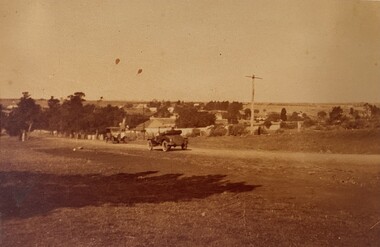
Photograph - Area - Suburb, Fawkner Street Westmeadows Looking North
... As a primary source, the photograph contributes to the documentation of Melbourne’s suburban expansion, offering valuable context for researchers, historians, and urban planners studying the evolution of the City of Hume. ...This photograph captures a historically significant streetscape in Westmeadows, formerly known as Broadmeadows Township, looking north from Fawkner Street. The image features a dirt road with a vintage automobile parked along its path, flanked by trees and modest residential buildings in the background. A tall utility or signpost stands prominently, indicative of early infrastructure in the area. The scene reflects the semi-rural character of Westmeadows prior to its suburban expansion in the post-war period. The presence of unsealed roads and early 20th-century vehicles suggests a time when the township served as a quiet residential and agricultural community, before the development of the Broadmeadows Housing Commission estate in the late 1940s. Historically, Westmeadows was a key waypoint along the Old Sydney Road, and its built environment—including bluestone bridges and early civic buildings—offers insight into Melbourne’s colonial and interwar development. This photograph contributes to the visual documentation of the City of Hume’s transformation from rural township to suburban district.This photograph holds historical and cultural significance as a visual record of Westmeadows, a township in Melbourne’s north-west, during the early 20th century. Captured from Fawkner Street looking north, the image depicts a dirt road flanked by modest residential buildings and mature trees, with a vintage automobile parked in the foreground. The presence of a tall utility or signpost adds to the authenticity of the streetscape. The image is emblematic of Westmeadows’ semi-rural character prior to its suburban transformation in the post-war era. It reflects the township’s role as a quiet residential and agricultural community, shaped by its proximity to the Old Sydney Road and its historical function as a waypoint for travelers. The architectural style and infrastructure visible in the photograph provide insight into the urban morphology and transport conditions of the time. As a primary source, the photograph contributes to the documentation of Melbourne’s suburban expansion, offering valuable context for researchers, historians, and urban planners studying the evolution of the City of Hume. It is significant for its ability to convey the lived experience, landscape, and development patterns of a community in transition.Sepia tone photo. Two cars on road. Trees, some buildings behind. Open land. Street view.'Looking north Fawkner Street Westmeadows'/'PH-0018' (old catalogue number)westmeadows, fawkner street, north, car -
 Kew Historical Society Inc
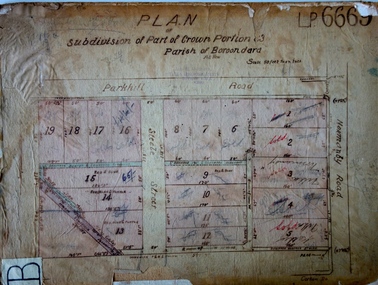
Plan - Subdivision Plan, J R Mathers & McMillan, Plan of Subdivision of Part of Crown Portion 83 at Kew : LP6669, 1923-1939
... This subdivision represents an attempt by auctioneers, rather than town planners to create an urban environment from larger residential allotments or in many cases farmland. ...This subdivision represents an attempt by auctioneers, rather than town planners to create an urban environment from larger residential allotments or in many cases farmland. ...In 1888, in the section of Park Hill Road between Belmont Avenue and Normanby Road there was only one street running between Park Hill Road and Cotham Road. This was Park Road, later to be named Adeney Avenue. Subsequent 20th century subdivisions created the ‘through roads’ of Cecil Street, Wimba Avenue, Florence Avenue, Marshall Avenue, Uvadale Road, and Barrington Avenue. This subdivision represents an attempt by auctioneers, rather than town planners to create an urban environment from larger residential allotments or in many cases farmland. Existing streets such as Parkhill and Normanby Roads provided a convenient starting point for the surveyors, but the Road named ‘Street Street’ indicates the role of the private surveyor in creating streets. Given that a number of allotments are listed as sold on the plan, the street is presumably Cecil Street. Even those lots that had been sold do not quite match the dimensions of the blocks in this parcel of land today, indicating that either further subdivisions or boundary alterations occurred.Subdivision plans are historically important documents used as evidence for the growth of suburbs in Australia. They frequently provide information about when the land was sold as well as evidence relating to surveyors and real estate and financial agents. The numerous subdivision plans in the Kew Historical Society's collection represent working documents, ranging from the initial sketches made in planning a subdivision to printed plans on which auctioneers or agents listed the prices for which individual lots were sold. In a number of cases, the reverse of a subdivision plan in the collection includes a photograph of a house that was also for sale by the agent. These photographs provide significant heritage information relating house design and decoration, fencing and household gardens.The photograph may also be aesthetically significant depending on the importance of the photographic atelier.Hand-drawn subdivision plan of 19 lots facing Parkhill Road, Normanby Road, and an unnamed street [now Cecil Street] in Kew.Estate Agent notes in ink indicate those lots which had sold.subdivision plans - kew, parkhill road - kew, cecil street - kew, normanby road - kew, cecil street -kew, parkhill road - kew, normanby road - kew, crown portion 83 - kew -
 Kew Historical Society Inc
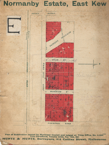
Plan - Subdivision Plan, Normanby Estate, East Kew, 1913
... urban Melbourne from the beginning of the 20th Century up until the 1980s. A number of the plans are double-sided and often include a photograph on the reverse. subdivision plans - kew normanby estate The Normanby Estate, which was adjacent to Normanby Road, Kew East, included thirty-one lots for sale. Streets on the subdivision plan include Adeney Avenue, Park Hill Road, Normanby Road, Weir Street and Wharton Street. Cotham Road and its tramway are shown nearby. The plan is interesting as it shows Wharton Street, named after the architect and town planner ...Pru Sanderson, in her groundbreaking ‘City of Kew Urban Conservation Study : Volume 2 - Development History’ (1988), summarised the periods of urban development and subdivisions of land in Kew. The periods that she identified included 1845-1880, 1880-1893, 1893-1921, 1921-1933, 1933-1943, and Post-War Development. These periods were selected as they represented periods of rapid growth or decline in urban development. An obvious starting point for Sanderson’s groupings involved population growth and the associated economic cycles. These cycles also highlighted urban expansion onto land that was predominantly rural, although in other cases it represented the decline and breakup of large estates. A number of the plans in the Kew Historical Society’s collection can also be found in other collections, such as those of the State Library of Victoria and the Boroondara Library Service. A number are however unique to the collection.The Kew Historical Society collection includes almost 100 subdivision plans pertaining to suburbs of the City of Melbourne. Most of these are of Kew, Kew East or Studley Park, although a smaller number are plans of Camberwell, Deepdene, Balwyn and Hawthorn. It is believed that the majority of the plans were gifted to the Society by persons connected with the real estate firm - J. R. Mathers and McMillan, 136 Cotham Road, Kew. The Plans in the collection are rarely in pristine form, being working plans on which the agent would write notes and record lots sold and the prices of these. The subdivision plans are historically significant examples of the growth of urban Melbourne from the beginning of the 20th Century up until the 1980s. A number of the plans are double-sided and often include a photograph on the reverse. The Normanby Estate, which was adjacent to Normanby Road, Kew East, included thirty-one lots for sale. Streets on the subdivision plan include Adeney Avenue, Park Hill Road, Normanby Road, Weir Street and Wharton Street. Cotham Road and its tramway are shown nearby. The plan is interesting as it shows Wharton Street, named after the architect and town planner George Wharton, who was the first chairman of the Municipality of Kew. The street was to later be renamed Cecil Street. Also shown are proposed ‘Municipal Gardens’ where Parkhill Drive is now located.subdivision plans - kew, normanby estate