Showing 59 items matching " victoria quartz area"
-
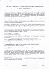
 Bendigo Historical Society Inc.
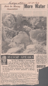
Newspaper - VICTORIA HILL - VICTORIA QUARTZ AREA
... VICTORIA HILL - VICTORIA QUARTZ AREA...... Victoria Quartz Area...It is the area at the rear of John Brown Knitting Mills, Ironbark. Newspaper VICTORIA HILL - VICTORIA QUARTZ AREA ...Newspaper photo from the Bendigo Advertiser dated 15/7/67. Photo shows an open cut area with rubbish in it. At the far end is a tunnel and in the foreground are rocks. It is the area at the rear of John Brown Knitting Mills, Ironbark.newspaper, bendigo advertiser, victoria hill, victoria quartz area, bendigo advertiser 15/7/67, john brown knitting mills ironbark -
 Warrnambool and District Historical Society Inc.
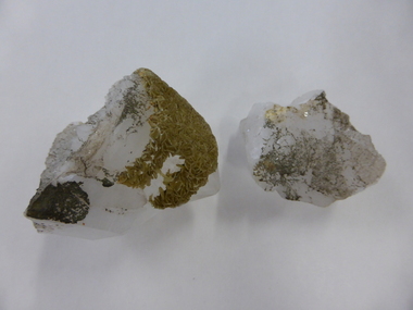
Crystal, Quartz crystal pieces x2
... The quartz would probably not have come from our area (Western District of Victoria)....The quartz would probably not have come from our area (Western District of Victoria). ...No information is available on these two items which would have been collected and polished by someone, probably someone interested in lapidary. The quartz would probably not have come from our area (Western District of Victoria).These items have no known local significance and will be useful only for display. These are two white quartz crystals with gold and silvery encrustations and markings. They are rough on the top and cut into geometric shapes and polished on the bottom part. The larger piece seems to have been fused together or split at one stage. quartz crystals, warrnambool -
 Orbost & District Historical Society
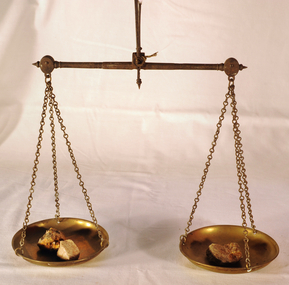
scales, Circa 1850's
... area of Central Victoria by Albert Charles Nicholls, who was a licensed assayer. This information comes from David Gordon of the Tarnagulla.com web-site. “The Nicholls family were very well known and highly respected at Tarnagulla in the 1800s. Albert's father, William Nicholls, was a leading figure in the gold mining community, and he both managed and owned quartz...area of Central Victoria by Albert Charles Nicholls, who was a licensed assayer. This information comes from David Gordon of the Tarnagulla.com web-site. “The Nicholls family were very well known and highly respected at Tarnagulla in the 1800s. Albert's father, William Nicholls, was a leading figure in the gold mining community, and he both managed and owned quartz ...Scales were used in the Tarnagulla area of Central Victoria by Albert Charles Nicholls, who was a licensed assayer. This information comes from David Gordon of the Tarnagulla.com web-site. “The Nicholls family were very well known and highly respected at Tarnagulla in the 1800s. Albert's father, William Nicholls, was a leading figure in the gold mining community, and he both managed and owned quartz processing facilities for decades. He was probably the leading mining expert at Tarnagulla in a town full of mining experts, and it was said that no man at Tarnagulla had handled more gold over the years that him. (think in terms of tons of gold!) I would imagine the assaying equipment was probably passed in due course by William to Albert Charles. There are records of Albert Charles mining at Tarnagulla with his father as a young man, but AC apparently came down to the city when the gold began to fade. There are records of him living in Kew up until his death in 1932. He was employed as a draper for a long period.” This item is a significant item which is part of the history of gold mining in Victory.Gold assayer's scales, a very sensitive balance used in the assaying of gold, silver, etc.The scales are comprised of two circular brass pans suspended via brass chains to a metal balance.scales gold technology assayers tarnagulla -
 Federation University Historical Collection
Book, George Brown, Prospectors' Guide (Victoria), 1936, 1936
... Barker Library (top floor) Mount Helen goldfields prospecting gold geology quartz reefs indicators ballarat indicators miners' rights mining leases forest regulations equipment gold cradle puddling machine sluice box whim whip california pump cradle mining tools mining laws Brown soft covered book with pullout map showing auriferous areas of Victoria. ...Brown soft covered book with pullout map showing auriferous areas of Victoria. prospecting, gold, geology, quartz reefs, indicators, ballarat indicators, miners' rights, mining leases, forest regulations, equipment, gold cradle, puddling machine, sluice box, whim, whip, california pump, cradle, mining, tools, mining laws -
 Bendigo Historical Society Inc.
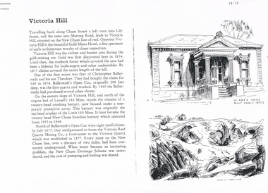
Document - LONG GULLY HISTORY GROUP COLLECTION: VICTORIA HILL
... The second page has a map of the Victoria Hill Area showing streets and the New Chum Anticline, a sketch of Ballerstedt's Open Cut and a Key to Victoria Hill Area Map. The third page mentions the Victoria Quartz... showing streets and the New Chum Anticline, a sketch of Ballerstedt's Open Cut and a Key to Victoria Hill Area Map. The third page mentions the Victoria Quartz mine, Tributors and quartz roasting. ...Three pages numbered 18/19, 20/21 and 22/23 titled Victoria Hill. First page has some information on Victoria Hill, a sketch of W Rae's Home and Rae's Open cut. The second page has a map of the Victoria Hill Area showing streets and the New Chum Anticline, a sketch of Ballerstedt's Open Cut and a Key to Victoria Hill Area Map. The third page mentions the Victoria Quartz mine, Tributors and quartz roasting. It also has sketch of a 20 Head Crushing Battery, Victoria Hill.bendigo, history, long gully history group, the long gully history group - victoria hill, gold mines hotel, christopher ballerstedt, theodore ballerstedt, ballerstedt's open cut, lansell's 180 mine, little 180 mine, new chum syncline battery, victoria reef quartz mining co, victoria quartz, new chum drainage scheme, a roberts and sons, tributors, william rae's bon accord mine and open cut, william rae, adventure and advance open cuts, central nell gwynne, heinz butcher shop -
 The Beechworth Burke Museum
Geological specimen - Feldspathic Sandstone
... quartz, and more feldspar than unstable lithic fragments, and minor accessory minerals.Feldspathic sandstones are commonly immature or sub-mature.These sandstones occur in association with cratonic or stable shelf settings. Feldspathic sandstones are derived from granitic-type, primary crystalline, rocks. If the sandstone is dominantly plagioclase, then it is igneous in origin Sandstone features prominently in public buildings throughout Victoria. Most of the sandstone used as dimension stone in the State came from three sources: the Heatherlie quarry in the Grampians (Silurian), the Bacchus Marsh area...quartz, and more feldspar than unstable lithic fragments, and minor accessory minerals.Feldspathic sandstones are commonly immature or sub-mature.These sandstones occur in association with cratonic or stable shelf settings. Feldspathic sandstones are derived from granitic-type, primary crystalline, rocks. If the sandstone is dominantly plagioclase, then it is igneous in origin Sandstone features prominently in public buildings throughout Victoria. Most of the sandstone used as dimension stone in the State came from three sources: the Heatherlie quarry in the Grampians (Silurian), the Bacchus Marsh area ...Feldspathic arenites are sandstones that contain less than 90% quartz, and more feldspar than unstable lithic fragments, and minor accessory minerals.Feldspathic sandstones are commonly immature or sub-mature.These sandstones occur in association with cratonic or stable shelf settings. Feldspathic sandstones are derived from granitic-type, primary crystalline, rocks. If the sandstone is dominantly plagioclase, then it is igneous in origin Sandstone features prominently in public buildings throughout Victoria. Most of the sandstone used as dimension stone in the State came from three sources: the Heatherlie quarry in the Grampians (Silurian), the Bacchus Marsh area (Permian), and the Barrabool Hills near Geelong (Cretaceous).Sandstone features prominently in public buildings throughout Victoria, making this specimen special as it shows the materials used by Victorian building companies. Sandstone can also be crushed, crushed stone is used in the construction of roadways and road structures such as bridges, and in buildings, both commercial and residential. This specimen is part of a larger collection of geological and mineral specimens collected from around Australia (and some parts of the world) and donated to the Burke Museum between 1868-1880. A large percentage of these specimens were collected in Victoria as part of the Geological Survey of Victoria that begun in 1852 (in response to the Gold Rush) to study and map the geology of Victoria. Collecting geological specimens was an important part of mapping and understanding the scientific makeup of the earth. Many of these specimens were sent to research and collecting organisations across Australia, including the Burke Museum, to educate and encourage further study. A feldspar-rich sandstone, a sandstone intermediate in composition between an arkosic sandstone and a quartz sandstone, containing 10% to 25% feldspar and less than 20% matrix material of clay, sericite, and chlorite. Feldspathic arenite containing less than 90 percent of the composition of quartz. Feldspar is the main composition. Feldspathic arenite may contain fragments of unstable rock, and a little amount of other minerals such as mica and heavy minerals. Some feldspathic arenite have pink or red color because of the presence of potassium feldspar or iron oxide. There are also colored light gray to white. These sandstones are usually medium to coarse grained and can contain a high percentage of granules with angular until subangular roundness. The content of the matrix can appear as the rest up to more than 15 percent, and sorting of grains can present as moderate to poorly sorted. Feldspathic sandstones are generally immature in textural maturity. Feldspathic arenite can not be judged from the structure of the sediment. Bedding can emerge from the laminate parallel to the crossbed. Fossils may appear in the layer deposited on the sea. Feldspathic arenites usually appear on the craton or the continental shelf, which can be associated with conglomerate, quartz lithic arenite, carbonate rock, or evaporites. This sandstone may also appear on the succession of sedimentary basins deposited on an unstable or deep sea, and moving arc setting. According to Pettijohn (1963) Arkose make up about 15 percent of all sandstones. Some Arkose formed in situ when the granite and related rocks disintegrate and generate granular sediments. Most of the material feldspathic sandstones derived from primary crystalline granitic rocks, such as granite or metasomatic rocks containing abundant potassium feldspar. Mineral contained in sandstones is mostly a form of plagioclase feldspar derived from quartz diorite or volcanic rock. Feldspar contained on this sandstone comes from arid to cool climates when the chemical weathering process is reduced.sandstone, natural stone, feldspathic sandstone, burke museum, geology, geological, geological specimen -
 The Beechworth Burke Museum
Geological specimen - Unknown, possible Carnelian Agate or Chalcedony
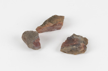
... area. The discovery of gold in Victoria, for instance, had a significant influence on the development of the area now known as 'the goldfields', including Beechworth; the city of Melbourne and Victoria as a whole. Agate occurs when amygdales (gas pockets) form in the upper levels of basaltic lava flows. If these pockets or bubbles are iniltrated by water bearing silica in solution, the fluid dries and hardens in layers, forming round or egg shaped nodules or geodes within the rocky matrix. Agate is formed of a silica mineral chalcedony similar to quartz...area. The discovery of gold in Victoria, for instance, had a significant influence on the development of the area now known as 'the goldfields', including Beechworth; the city of Melbourne and Victoria as a whole. Agate occurs when amygdales (gas pockets) form in the upper levels of basaltic lava flows. If these pockets or bubbles are iniltrated by water bearing silica in solution, the fluid dries and hardens in layers, forming round or egg shaped nodules or geodes within the rocky matrix. Agate is formed of a silica mineral chalcedony similar to quartz ...Although it is not known where these specimens were collected, Victoria and other regions of Australia were surveyed for sites of potential mineral wealth throughout the 19th Century. The identification of sites containing valuable commodities such as gold, iron ore and gemstones in a locality had the potential to shape the development and history of communities and industries in the area. The discovery of gold in Victoria, for instance, had a significant influence on the development of the area now known as 'the goldfields', including Beechworth; the city of Melbourne and Victoria as a whole. Agate occurs when amygdales (gas pockets) form in the upper levels of basaltic lava flows. If these pockets or bubbles are iniltrated by water bearing silica in solution, the fluid dries and hardens in layers, forming round or egg shaped nodules or geodes within the rocky matrix. Agate is formed of a silica mineral chalcedony similar to quartz. The term carnelian primarily refers to the reddish shading of the stone; whether the stone is termed an agate or chalcedony type is often influenced by the degree of colour banding the specimen shows. The specimens are significant as examples of surveying activity undertaken to assess and direct the development of the mineral resource industries in Victoria and Australia, as well as the movement to expand human knowledge of earth sciences such as mineralogy and geology in the nineteenth century.Three small geological specimens that appear visually consistent with images of rough or unpolished Carnelian Agate or Chalcedony. geological specimen, geology, geology collection, burke museum, beechworth, indigo shire, north-east victoria, gemstones, agate, carnelian -
 The Beechworth Burke Museum
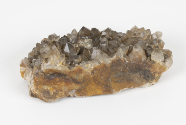
Geological specimen - Smoky quartz crystals, unknown
... quartz are formed in deep-seated igneous rocks and crystallized through hot aqueous solutions. This type of crystal can be found all over Australia, including Beechworth in Victoria. Other places quartz can be found is the Ashburton River area...quartz are formed in deep-seated igneous rocks and crystallized through hot aqueous solutions. This type of crystal can be found all over Australia, including Beechworth in Victoria. Other places quartz can be found is the Ashburton River area ...Quartz is an extremely common mineral to find across the world. Quartz can have two forms; Microcrystalline quartz or Crystalline quartz. Microcrystalline quartz is a fine grain quartz where crystalline quartz is often a large crystal. This specimen is a crystalline quartz. Made of silicon oxide, this specimen is called smokey quartz crystals because of its brownish colour. However, the colour of quartz can vary. In addition, quartz are formed in deep-seated igneous rocks and crystallized through hot aqueous solutions. This type of crystal can be found all over Australia, including Beechworth in Victoria. Other places quartz can be found is the Ashburton River area in Western Australia, Marlborough in Queensland, the Lune River area in Tasmania and Kingsgate in New South Wales. This specimen is significant because it is common to find this kind of mineral. While the location of where this specimen was originally from is unknown, it highlights the many places in Australia where quartz is found. It demonstrates that quartz makes up a large portion of Australia's geology. In addition, quartz itself can vary in its colour and shape. This specimen represents one of these variations. That being smoky quartz crystals. This specimen is part of a larger collection of geological and mineral specimens collected from around Australia (and some parts of the world) and donated to the Burke Museum between 1868-1880. A large percentage of these specimens were collected in Victoria as part of the Geological Survey of Victoria that begun in 1852 (in response to the Gold Rush) to study and map the geology of Victoria. Collecting geological specimens was an important part of mapping and understanding the scientific makeup of the earth. Many of these specimens were sent to research and collecting organisations across Australia, including the Burke Museum, to educate and encourage further study.A large hand-sized quartz mineral with shades of brown and gray throughout.Smoky quartz / crystals /locality/ unknown / (needs a wash) /BBgeological specimen, geology, geology collection, burke museum, beechworth, microcrystalline, quartz, quartz mining, quartz reefs beechworth, smokey quartz crystals, crystals, crystalline, silicon oxide, brown, colour, igneous rocks, magma, ashburton river, western australia, marlborough, queensland, lune river, tasmania, kingsgate, new south wales, nsw -
 The Beechworth Burke Museum
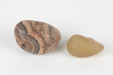
Geological specimen - Agate and Quartz pebbles
... quartz can vary. These specimens were collected in Victoria in the vicinity of the Burke Museum. Victoria and other regions of Australia were surveyed for sites of potential mineral wealth throughout the 19th Century. The identification of sites containing valuable commodities such as gold, iron ore and gemstones in a locality had the potential to shape the development and history of communities and industries in the area. ...quartz can vary. These specimens were collected in Victoria in the vicinity of the Burke Museum. Victoria and other regions of Australia were surveyed for sites of potential mineral wealth throughout the 19th Century. The identification of sites containing valuable commodities such as gold, iron ore and gemstones in a locality had the potential to shape the development and history of communities and industries in the area. ...Agate occurs when amygdales (gas pockets) form in the upper levels of basaltic lava flows. If these pockets or bubbles are iniltrated by water bearing silica in solution, the fluid dries and hardens in layers, forming round or egg shaped nodules or geodes within the rocky matrix. Agate is formed of a silica mineral chalcedony similar to quartz. Although relatively common and semi-precious, agate has been prized since at least 1450 BC - an intricately carved agate seal was found in the 2015 excavation of a grave belonging to a Mycenaeum priest or warrior near Pylos in Greece. Agate is also used in jewellery and other decorative or ritual purposes due to its often striking appearance. Quartz is found all over Australia, including Beechworth in Victoria. It is formed in deep-seated igneous rocks and crystallized through hot aqueous solutions. It can have two forms; Microcrystalline quartz or Crystalline quartz. Microcrystalline quartz is a fine grain quartz where crystalline quartz is often a large crystal. The colour of quartz can vary. These specimens were collected in Victoria in the vicinity of the Burke Museum. Victoria and other regions of Australia were surveyed for sites of potential mineral wealth throughout the 19th Century. The identification of sites containing valuable commodities such as gold, iron ore and gemstones in a locality had the potential to shape the development and history of communities and industries in the area. The discovery of gold in Victoria, for instance, had a significant influence on the development of the area now known as 'the goldfields', including Beechworth; the city of Melbourne and Victoria as a whole.The specimens are significant as examples of surveying activity undertaken to assess and direct the development of the mineral resource industries in Victoria and Australia, as well as the movement to expand human knowledge of earth sciences such as mineralogy and geology in the nineteenth century.Geological specimens of Agate and Quartz respectively; the fist-sized piece of Agate has peach/coral colouring with grey concentric patterning and the smaller piece of quartz is a uniform yellow/orange shade. Existing label: Local pebbles / (agate and / quartz / (yellowish) / egg-shaped). / BB geological specimen, geology, geology collection, burke museum, beechworth, agate, quartz, north-east victoria, indigo shire, geological surveys -
 The Beechworth Burke Museum
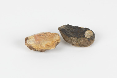
Geological specimen - North Queensland Agates, Unknown
... quartz. Although relatively common and semi-precious, agate has been prized since at least 1450 BC - an intricately carved agate seal was found in the 2015 excavation of a grave belonging to a Mycenaeum priest or warrior near Pylos in Greece. Agate is also used in jewellery and other decorative or ritual purposes due to its often striking appearance. These specimens originated in North Queensland, which contains noted agate-fossicking regions such as in the area surrounding Forsayth. They were collected in approximately 1852 as an adjunct to the Geological Survey of Victoria...quartz. Although relatively common and semi-precious, agate has been prized since at least 1450 BC - an intricately carved agate seal was found in the 2015 excavation of a grave belonging to a Mycenaeum priest or warrior near Pylos in Greece. Agate is also used in jewellery and other decorative or ritual purposes due to its often striking appearance. These specimens originated in North Queensland, which contains noted agate-fossicking regions such as in the area surrounding Forsayth. They were collected in approximately 1852 as an adjunct to the Geological Survey of Victoria ...Agate occurs when amygdales (gas pockets) form in the upper levels of basaltic lava flows. If these pockets or bubbles are iniltrated by water bearing silica in solution, the fluid dries and hardens in layers, forming round or egg shaped nodules or geodes within the rocky matrix. Agate is formed of a silica mineral chalcedony similar to quartz. Although relatively common and semi-precious, agate has been prized since at least 1450 BC - an intricately carved agate seal was found in the 2015 excavation of a grave belonging to a Mycenaeum priest or warrior near Pylos in Greece. Agate is also used in jewellery and other decorative or ritual purposes due to its often striking appearance. These specimens originated in North Queensland, which contains noted agate-fossicking regions such as in the area surrounding Forsayth. They were collected in approximately 1852 as an adjunct to the Geological Survey of Victoria. It was donated to the Museum in 1868. Victoria and other regions of Australia were surveyed for sites of potential mineral wealth throughout the 19th Century. The identification of sites containing valuable commodities such as gold, iron ore and gemstones in a locality had the potential to shape the development and history of communities and industries in the area. The discovery of gold in Victoria, for instance, had a significant influence on the development of the area now known as 'the goldfields', including Beechworth; the city of Melbourne and Victoria as a whole. The specimens are significant as examples of surveying activity undertaken to assess and direct the development of the mineral resource industries in Victoria and Australia, as well as the movement to expand human knowledge of earth sciences such as mineralogy and geology in the nineteenth century. Two solid egg-sized pieces of peach/orange toned agate (a common semi-precious chalcedony, similar to quartz) with a striped pattern, embedded in a light and dark brown matrix. geological specimen, geology, geology collection, burke museum, beechworth, agate, north queensland agate, 1852 geological survey of victoria, l. hufer - donor, mineralogy, agate specimen, indigo shire -
 The Beechworth Burke Museum
Photograph, Unknown
... Victoria. Gold was discovered at the A1 site in 1861 and mining operations began in 1864. The A1 Mine Settlement refers to a small township known variously as Castle Reef, Castle Point, and Raspberry Creek, which developed in the 1860s around mining industry centred on a crushing machine that worked the three gold reefs in the area. Historically, the name "A1"referred to the high quality of gold found in the quartz...Victoria. Gold was discovered at the A1 site in 1861 and mining operations began in 1864. The A1 Mine Settlement refers to a small township known variously as Castle Reef, Castle Point, and Raspberry Creek, which developed in the 1860s around mining industry centred on a crushing machine that worked the three gold reefs in the area. Historically, the name "A1"referred to the high quality of gold found in the quartz ...The A1 Gold Mine is located north of Woods Point, near Jamieson, in the Upper Goulburn region of Victoria. Gold was discovered at the A1 site in 1861 and mining operations began in 1864. The A1 Mine Settlement refers to a small township known variously as Castle Reef, Castle Point, and Raspberry Creek, which developed in the 1860s around mining industry centred on a crushing machine that worked the three gold reefs in the area. Historically, the name "A1"referred to the high quality of gold found in the quartz reefs at depths of at least two thousand feet. Along with the Morning Star mine at Woods Point, the A1 gold mine produced almost sixty percent of Victoria's gold output in the 1950s to 1970s and continued operating until 1992 when it went into administration. Operations at the site were revived in 2016 and the A1 Mine is now considered one of Victoria's premier gold mines. The A1 mine is part of the extensive and prospective Lachlan Fold Belt, a north-west trending belt of tightly folded Early Devonian sedimentary rocks extending from New South Wales to Victoria. Mineralisation is hosted within or immediately adjacent to diorite dykes. Contemporary development of the 'Queens Lode' at the A1 mine signals a move from high-grade, narrow vein airleg mining into larger scale, mechanical mining designed to increase ore production volume. This original, undated photograph of the A1 Mine appears to depict an area or phase of disuse or abandonment. The aged and humble appearance of the cottage suggests association with the historical A1 Mine Settlement, therefore the image may have been taken prior to the 1950s-1970s revival period in which the A1 mine is known to have produced high gold yields. The photograph contributes to our understanding of the A1 Gold Mine's impact on the landscape and the social, environmental impacts of mining on communities and may be compared with others in the Burke Museum's extensive collection of mining photographs to deepen our understanding of mining in the Jamieson area.Black and white rectangular photograph printed on photographic paperReverse: 5577 / A1 Mine / Near Jamieson / Vic. /burke museum, beechworth museum, beechworth, gold fields, gold rush, victorian gold rush, mining tunnels, gold ming history, colonial australia, australian gold rushes, mining technology, beechworth historic district, indigo gold trail, indigo shire, upper goulburn shire, jamieson, woods point-walhalla goldfield, a1 gold mine, victorian high country, modern mining methods, orogenic gold province, gold mineralisation, devonian, dykes -
 Eltham District Historical Society Inc
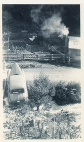
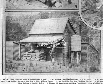
Photograph, Queenstown - St. Andrews District. "Quartz awaiting crushing at the State Battery in Smith's Gully.", c.1929
... area from the 1920s. The battery crushed the gold bearing quartz extracted from the mines and was a sizeable weatherboard building enclosing the engine and stampers. All that now remains are the bases for the machinery that comprised the battery, one timber and a couple of concrete bases and the nearby dam, which supplied water. However the historic significance of the site remains and is enhanced by the Queenstown Cemetery on the other side of Smiths Gully Road". - Bick Study 1922 This site is now the Peter Franke Reserve and is managed by Parks Victoria...area from the 1920s. The battery crushed the gold bearing quartz extracted from the mines and was a sizeable weatherboard building enclosing the engine and stampers. All that now remains are the bases for the machinery that comprised the battery, one timber and a couple of concrete bases and the nearby dam, which supplied water. However the historic significance of the site remains and is enhanced by the Queenstown Cemetery on the other side of Smiths Gully Road". - Bick Study 1922 This site is now the Peter Franke Reserve and is managed by Parks Victoria ..."The State Battery was the central component in the gold mining of this area from the 1920s. The battery crushed the gold bearing quartz extracted from the mines and was a sizeable weatherboard building enclosing the engine and stampers. All that now remains are the bases for the machinery that comprised the battery, one timber and a couple of concrete bases and the nearby dam, which supplied water. However the historic significance of the site remains and is enhanced by the Queenstown Cemetery on the other side of Smiths Gully Road". - Bick Study 1922 This site is now the Peter Franke Reserve and is managed by Parks Victoria Photo Source: The Leader, Nov. 2nd, 1929This photo forms part of a collection of photographs gathered by the Shire of Eltham for their centenary project book,"Pioneers and Painters: 100 years of the Shire of Eltham" by Alan Marshall (1971). The collection of over 500 images is held in partnership between Eltham District Historical Society and Yarra Plenty Regional Library (Eltham Library) and is now formally known as the 'The Shire of Eltham Pioneers Photograph Collection.' It is significant in being the first community sourced collection representing the places and people of the Shire's first one hundred years.Digital imagesepp, shire of eltham pioneers photograph collection, queenstown, st andrews, gold mining, smiths gully -
 Bendigo Historical Society Inc.
Plan - Victoria Quartz Gold Mine
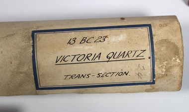
... Victoria Quartz Gold Mine was situated on Victoria Hill, Ironbark, (1877 - 1913). At the turn of the century, this was the site of one of the premier mines on the Bendigo goldfield. In 1908, it boasted the world's deepest shaft - 4,478 feet (1,365 metres). The shaft reached a depth of 4,613 feet (1,406 metres) in 1910. In 1857 eight small claims in this area...Victoria Quartz Gold Mine was situated on Victoria Hill, Ironbark, (1877 - 1913). At the turn of the century, this was the site of one of the premier mines on the Bendigo goldfield. In 1908, it boasted the world's deepest shaft - 4,478 feet (1,365 metres). The shaft reached a depth of 4,613 feet (1,406 metres) in 1910. In 1857 eight small claims in this area ...The Victoria Quartz Gold Mine was situated on Victoria Hill, Ironbark, (1877 - 1913). At the turn of the century, this was the site of one of the premier mines on the Bendigo goldfield. In 1908, it boasted the world's deepest shaft - 4,478 feet (1,365 metres). The shaft reached a depth of 4,613 feet (1,406 metres) in 1910. In 1857 eight small claims in this area had been merged to form the Victoria Reef Quartz Mining Co. Another merger in 1877 led to the formation of the Victoria Quartz Co. For the next three decades, the mine produced consistent profits. In 1910, water burst into the claim, flooding the shaft and halting operations. The company baled water for six months then handed the mine over to the tributers who worked the upper levels for the share of the profits. The mine closed in 1913, having produced over 48,000 ounces of gold and paid dividends of £99,600. (Source, Goldfield Guide https://www.goldfieldsguide.com.au/explore-location/400/victoria-hill-mining-reserve/) Victorian Heritage Register information on mine: Statement of Significance Last updated on - July 14, 2005 The story of quartz mining on Victoria Hill lies at the heart of Bendigo's historical status as the world's richest and deepest reefing field. Gold was discovered on Victoria Hill in 1854, and by early 1855 claims had been taken up over its entire extent. Shafts were first worked by windlass, whip or whim, and primitive crushing batteries were in operation. By 1861, Victoria Hill had yielded at least 1,200,000oz in gold. One of the early claims on Victoria Hill was owned by Prussian immigrants, Christopher Ballerstedt and his son Theodore. In 1854, they bought a claim on the hill for £80, to which they subsequently added other claims, and from the quartz veins (called spurs), worked both by shafts and a large open cut, obtained gold worth nearly £200,000. Christopher Ballerstedt was dubbed 'Father of the Hill' and has been credited as the first to debunk the theory at that time prevalent on the Bendigo field, that the gold content of reefs would diminish at depth. As his shafts plunged below the 200-foot level, the quartz remained rich in gold. His success inspired others, and so led the way to Bendigo's later status as the world's deepest and richest goldfield. The Ballerstedt's built Bendigo's grandest mansion, Fortuna. Theodore continued to work Victoria Hill after his father's death, but in 1871, convinced that his claim was exhausted, he sold both mine and mansion to George Lansell for £60,000. Lansell's mine on Victoria Hill was called the 180, and operated under his ownership until his death in 1906. The mine supplied the initial wealth that made Lansell Bendigo's 'Quartz King'. George Lansell was such a force in Bendigo's mining history that his death was cited as one of the reasons for the decline of Bendigo as a quartz mining centre, The Victoria Hill Quartz Gold Mines are of historical, archaeological and scientific importance to the State of Victoria. The Victoria Hill Quartz Gold Mines are historically significant as the symbolic heart of Bendigo's famous goldfield. The mines are linked to nineteenth-century individuals (Christopher Ballerstedt and George Lansell) who played prominent roles in the evolution of Bendigo. Both men's fortunes and their influence on Bendigo, originated from mining operations carried out on the hill. The Victoria Hill Quartz Gold Mines are historically and scientifically important as characteristic examples of an important form of gold mining. Gold mining sites are of crucial importance for the pivotal role they have played since 1851 in the development of Victoria. As well as being a significant producer of Victoria's nineteenth century wealth, quartz mining, with its intensive reliance on machinery, played an important role in the development of Victorian manufacturing industry. The Victoria Hill Quartz Gold Mines are important as a manifestation of this aspect of gold mining. The Victoria Hill Quartz Gold Mines are scientifically important, as they contain relics span nearly sixty years of mining (1854 to 1913), documenting the richest and most significant years of Bendigo's world-famous quartz mining industry. Enhancing the significance of the place are relics from the Victoria Quartz Company operations, ncluding, at 4,870 feet, the world's deepest nineteenth-century gold mining shaft. As a postscript to the chronology of gold mining is the surviving crushing machinery (formerly part of the Bendigo Crushing Works) which was erected near the foundations of Lansell's 180 mine in 1932, to crush quartz for nearby mines. The place has a potential to yield artefacts and evidence which will be able to provide significant information about the technological history of gold mining. [Source: Victorian Heritage Register] Hermes Number 8506 https://vhd.heritagecouncil.vic.gov.au/index.php/places/8506/download-report Hand drawn plan of the bottom section of the Victoria Quartz Gold Mine. Mine shaft shown from 2706 feet to 5200 (potential) feet shown, with annotation regarding geological features and gold obtained from different level crushings. Blue border sticker on outside of plan: '13 BC 23 Victoria Quartz Trans-Section'. Plan is not dated. The Victoria Quartz plan is part of the Margaret Roberts Collection.victoria hill quartz gold mine, victoria hill -
 Bendigo Historical Society Inc.
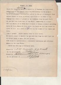
Administrative record - South New Chum Syncline Gold Mine permit to mine, 1932 - 1940
... Victoria Quartz. Lansell’s Big 180, North Old Chum and New Chum. (Bendigo Advertiser, 29th September 1932). Bendigo Gold mining South New Chum Syncline Gold Mine J.J. Stanistreet Legal Manager Margaret Roberts Collection Seven pages of correspondence detailing a 'Permit to Mine' in favour of Messrs W.J. Browell, A.W. Browell and A.R. Hannon, Golden Square, in respect of portion of the area ...South New Chum Syncline South New Chum Syncline Gold Mines, N.L., has been floated with a capital of £27,500 in 55,000 shares of 10/ each. Forty thousand have been issued at 1/,10,000 fully paid shares go to vendors, and 5000 will be held in reserve. - Messrs. Savage and Nicholas report that the issue was heavily over-subscribed. The property is situated in the central portion of the Bendigo field, adjoining such former producers as the Victoria Quartz. Lansell’s Big 180, North Old Chum and New Chum. (Bendigo Advertiser, 29th September 1932).Seven pages of correspondence detailing a 'Permit to Mine' in favour of Messrs W.J. Browell, A.W. Browell and A.R. Hannon, Golden Square, in respect of portion of the area held under Gold Mining Lease No. 9903. Letter dated 23rd February 1937 to J.J. Stanistreet, Legal Manager, South New Chum Syncline, Bendigo from Mines Department, Treasury Gardens, Melbourne confirms the permit held under Gold Mining Lease No. 9903, Bendigo. List of articles taken by Browell on 29th June, 1936, is attached. Draft copy of 'permit to mine' document attached. bendigo, gold mining, south new chum syncline gold mine, j.j. stanistreet, legal manager, margaret roberts collection, -
 Bendigo Historical Society Inc.
Document - LONG GULLY HISTORY GROUP COLLECTION: WM RAE CRUSHING WORKS
... area, he established a puddling machine in American Gully. He then bought a claim on the Victoria reef and was quite successful. Subsequently he bought a steam engine and three batteries to begin crushing quartz. ...area, he established a puddling machine in American Gully. He then bought a claim on the Victoria reef and was quite successful. Subsequently he bought a steam engine and three batteries to begin crushing quartz. ...William Rae (1823-1887) was born into a farming family in Scotland and came to Australia in i852. After coming to the Bendigo area, he established a puddling machine in American Gully. He then bought a claim on the Victoria reef and was quite successful. Subsequently he bought a steam engine and three batteries to begin crushing quartz. This was such a boon that he moved to a more convenient location in Happy Valley, where he set up a crushing battery with 35 heads.Sketch of a crushing works. Printed underneath is: Wm. Rae's Crushing Works, Happy Valley, Bendigo. Written on the back is: Happy Valley Rd. South side below Wells St. Picture shows a crushing works building with a tall chimney and some smaller outbuildings. On the hill in the background are poppet legs, other mine structures and some trees. There are heaps of mullock and in the foreground are a number of people.bendigo, history, long gully history group, the long gully history group - wm rae crushing works, george ellis -
 Bendigo Historical Society Inc.
Document - LONG GULLY HISTORY GROUP COLLECTION: BANKNOTES AND JAMES BEVERAGE
... In the City's formative years the area that deposited its rain water into the Long Gully Creek was considered to be in Long Gully and for many years the Victoria Quartz Mine deposited many thousands of gallons of water into the Long Gully Creek. ...In the City's formative years the area that deposited its rain water into the Long Gully Creek was considered to be in Long Gully and for many years the Victoria Quartz Mine deposited many thousands of gallons of water into the Long Gully Creek. ...Victoria Quartz Gold Mine was on Victoria Hill, Ironbark, Bendigo. The Victoria Hill Quartz Gold Mines are scientifically important, as they contain relics span nearly sixty years of mining (1854 to 1913), documenting the richest and most significant years of Bendigo's world-famous quartz mining industry. Enhancing the significance of the place are relics from the Victoria Quartz Company operations, including, at 4,870 feet, the world's deepest nineteenth-century gold mining shaft. (Heritage Victoria) Geology of Victoria Hill: https://aigjournal.aig.org.au/wp-content/uploads/2019/12/AIG-Victoria-Hill-Mining-Reserve_FinalWeb.pdfTyped copy of what appears to be a speech. Mentioned is that after 1910 the Commonwealth took over the minting it's own money. Gold mining was chosen for the one pound note and a Bendigo scene was chosen. The scene chosen shows boring operations in the Victoria Quartz Mine. The picture was taken by Vincent Kelly of the five figures but for engraving only three were shown. They were Mr W Healy, Mr J Smith and Mr James Beverage. James Beverage was a member of Bendigo's first fire brigade. He went to Beechworth for a demonstration and on the way home stopped at Christie's Hotel in Swanston Street. There was a fire at the hotel and Mr Beverage rescued Mrs Christie, her baby and a servant. At a later date Mr Beverage saved a woman from a burning building in Moore Street in Bendigo. He received the Royal Humane Society's Medal which is now housed at the Bendigo Fire Station in Hargreaves Street. In the City's formative years the area that deposited its rain water into the Long Gully Creek was considered to be in Long Gully and for many years the Victoria Quartz Mine deposited many thousands of gallons of water into the Long Gully Creek. Mr Steve Gibbons unveiled the plaque.bendigo, history, long gully history group, the long gully history group - banknotes and james beverage, victoria quartz mine, vincent kelly, shepard's bush, mr rickards, mr abraham, mr w healy, mr j smith, mr james beverage, south iron bark mine, rae's hill, sandhurst no 1 fire brigade, christie's hotel, mrs christie, royal humane society's medal, bendigo fire station, long gully history group, mr steve gibbons, department of environment water heritage, arts commnmoration of historic events and famous persons -
 Bendigo Historical Society Inc.
Document - ALBERT RICHARDSON COLLECTION: VICTORIA HILL IRONBARK
... Victoria Hill area. The open cuts on Victoria Hill; Lansell's Big 180 Mine, Victoria Quartz Mine; Wittscheibe's 'Jewellers Shop', Luffman and Sterry, Central Nell Gwynne and New Chum Hill are mentioned in the article. ...Victoria Hill area. The open cuts on Victoria Hill; Lansell's Big 180 Mine, Victoria Quartz Mine; Wittscheibe's 'Jewellers Shop', Luffman and Sterry, Central Nell Gwynne and New Chum Hill are mentioned in the article. ...Three page handwritten document outlining the history of the Victoria Hill area. The open cuts on Victoria Hill; Lansell's Big 180 Mine, Victoria Quartz Mine; Wittscheibe's 'Jewellers Shop', Luffman and Sterry, Central Nell Gwynne and New Chum Hill are mentioned in the article. A description of the suitability of the Victoria Hill site as a potential mining museum is discussed as 'it is centrla to both the northern and southern ends of the main portion of the Bendigo and Eaglehawk mines'. William Rae built two fine residences on Happy Valley Road, and also set up a 30 head battery out of his gains from Victoria Hill.bendigo, mining, victoria hill -
 Bendigo Historical Society Inc.
Document - BENDIGO AND VICTORIA HILL REPORT ON GEOLOGY
... Victoria Hill Area' Letter attached inside front cover to J.C.Balfour, Minister of Mines to G.A. Lambert, Liberal Party, Sunshine, Victoria, sent with book for his information. Report contains: Cobaw batholith and North Harcourt Bendigo goldfield generally Trought, reefs, saddles and spurs Victoria Hill mines; Victoria Consols, Great Central Victoria, Victoria Quartz, Lansells 180, North Old Chum. ...Victoria Hill Area' Letter attached inside front cover to J.C.Balfour, Minister of Mines to G.A. Lambert, Liberal Party, Sunshine, Victoria, sent with book for his information. Report contains: Cobaw batholith and North Harcourt Bendigo goldfield generally Trought, reefs, saddles and spurs Victoria Hill mines; Victoria Consols, Great Central Victoria, Victoria Quartz, Lansells 180, North Old Chum. ...Report, 8 pages, on the geology of Bendigo district and Victoria Hill, produced by the Geological Survey Dept., Victorian Government. G.J. Medwell, Geologist. 19.10.1967. On front 'Geological Survey of Victoria. Mines Department Victoria. Report on Geology of Bendigo and of Victoria Hill Area' Letter attached inside front cover to J.C.Balfour, Minister of Mines to G.A. Lambert, Liberal Party, Sunshine, Victoria, sent with book for his information. Report contains: Cobaw batholith and North Harcourt Bendigo goldfield generally Trought, reefs, saddles and spurs Victoria Hill mines; Victoria Consols, Great Central Victoria, Victoria Quartz, Lansells 180, North Old Chum. Maps attached show part of New Chum line of reef and a handdrawn map of Rae's Cutting.bendigo, mining, victoria hill, bendigo goldfield -
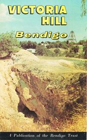
 Bendigo Historical Society Inc.
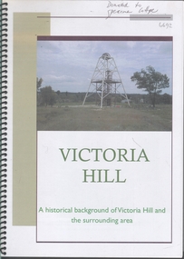
Booklet - Victoria Hill
... Victoria Hill, accessed from Marong Road, was one of the richest areas on the Bendigo goldfields and was the beginning of reef mining as opposed to alluvial mining. Between 1853 and 1861 there were 16 claims registered on Victoria Hill. Between 1908 and 1910 it was the site of the world's deepest shaft (1365-1406 meters)Today it provides interpretive walks that include sites such as an open-cut mine (1850's), poppet head, quartz crushing battery (1930's) and the foundations of George Lancell's 180 mine. ...Victoria Hill, accessed from Marong Road, was one of the richest areas on the Bendigo goldfields and was the beginning of reef mining as opposed to alluvial mining. Between 1853 and 1861 there were 16 claims registered on Victoria Hill. Between 1908 and 1910 it was the site of the world's deepest shaft (1365-1406 meters)Today it provides interpretive walks that include sites such as an open-cut mine (1850's), poppet head, quartz crushing battery (1930's) and the foundations of George Lancell's 180 mine. ...Victoria Hill, accessed from Marong Road, was one of the richest areas on the Bendigo goldfields and was the beginning of reef mining as opposed to alluvial mining. Between 1853 and 1861 there were 16 claims registered on Victoria Hill. Between 1908 and 1910 it was the site of the world's deepest shaft (1365-1406 meters)Today it provides interpretive walks that include sites such as an open-cut mine (1850's), poppet head, quartz crushing battery (1930's) and the foundations of George Lancell's 180 mine. It is registered as a site of historical significance.Clear plastic cover spiral bound booklet of 25 pages. 'Victoria Hill'. A historical background of Victoria Hill and the surrounding area. A colour photo of a poppet head on front. Original story written by Albert Richardson in 1971. This is a revised edition by Philip Wilkin in 2012. Illustrated with colour and B&W photos. Pages 13 to 25 have been inadvertently inserted upside down. A single page A4 leaflet 'Victoria Hill Self-Guided Tour' has been put inside after page 1Handwritten in ink on front page 'Donated to Specimen Cottage'victoria hill, gold mine -
 Bendigo Historical Society Inc.
Document - Hustlers, Sheepshead and Deborah lines of reef
... Mines listed on Hustlers line of reef: Fortuna Hustlers (1888 - 1913), shaft 2,240 feet at rear of Buckell and Jeffrey's offices; Royal Hustlers Reserve No. 2 - two shafts 'City" 860 feet, now covered by R.S.L. building Pall Mall, steel poppet legs 60 ft high and 'Park Shaft" at rear of Camp Hill School, 1,775 feet, steel poppet legs 60 feet high; Hustlers Hill Group first worked by Jonathan Harris in 1853 and bounded by Valentine, Anderson and Ironbark Creek to the north and Milroy Street to the east, one of first areas worked for quartz reefing. It with Garden Gully line west and Victoria Hill Ironbark, formed by far the richest cross section of the Bendigo Goldfield. ...Mines listed on Hustlers line of reef: Fortuna Hustlers (1888 - 1913), shaft 2,240 feet at rear of Buckell and Jeffrey's offices; Royal Hustlers Reserve No. 2 - two shafts 'City" 860 feet, now covered by R.S.L. building Pall Mall, steel poppet legs 60 ft high and 'Park Shaft" at rear of Camp Hill School, 1,775 feet, steel poppet legs 60 feet high; Hustlers Hill Group first worked by Jonathan Harris in 1853 and bounded by Valentine, Anderson and Ironbark Creek to the north and Milroy Street to the east, one of first areas worked for quartz reefing. It with Garden Gully line west and Victoria Hill Ironbark, formed by far the richest cross section of the Bendigo Goldfield. ...Albert Richardson was a mining historian who wrote widely on the mines of the Bendigo Goldfield. The park opposite the Goldmines Hotel in Marong Road, is named in his honour. Five page document, hand written by Albert Richardson on lined foolscap and edited with cross-outs and insertions, . The mines along the Hustlers line of reef and the Sheepshead line of reef are described. Mines listed on Hustlers line of reef: Fortuna Hustlers (1888 - 1913), shaft 2,240 feet at rear of Buckell and Jeffrey's offices; Royal Hustlers Reserve No. 2 - two shafts 'City" 860 feet, now covered by R.S.L. building Pall Mall, steel poppet legs 60 ft high and 'Park Shaft" at rear of Camp Hill School, 1,775 feet, steel poppet legs 60 feet high; Hustlers Hill Group first worked by Jonathan Harris in 1853 and bounded by Valentine, Anderson and Ironbark Creek to the north and Milroy Street to the east, one of first areas worked for quartz reefing. It with Garden Gully line west and Victoria Hill Ironbark, formed by far the richest cross section of the Bendigo Goldfield. Great Extended Hustlers (1865-1921) close to intersection of Anderson Street and Hustlers Road, mullock heap against road and shored up around shaft, steel poppet legs now at Wattle Gully mine, Chewton, large winding machine, air compressor south of shaft and 36 head crushing battery. Hustlers Reef (Old Hustlers) and Hustlers Reef No. 1, two shafts, main 2,210 feet, about 220 yards east of Moran Street and against Fenton Street. , No. 1 shaft 1,140 feet and about 155 yards east of Moran Street. Lansell's Comet, Lightining Hill line, 2.100 feet, on Comet Hill approx 70 yards west of Holmes Road, near Comet Creek, steel poppet legs. United Hustlers and Redan (1876-1918), main Redan, 1,830 feet about 155 yards west of Sandhurst Roead, in line with Comet Hill State School, this hill known as Redan Hill. North, or New Hustlers, once known as Agnew Hustlers, wooden poppet legs, south side, Kneebone Street, Eaglehawk. Derby line, Johnson's No. 3, South Johnson's (east shaft of Collman and Tacchi) 439 feet on west wide of Woods Street, south of Wetherall Street. Paddy's Gully Line, south to north, some shafts - Lansell's 'Sandhurst" ('Needle") Eaglehawk Road shaft 2,425 feet, about 50 yards east of Needle Loops, a brick square sided chimney with Cleopatra Needle top. British American, 789 feet, just south of Holdsworth Road. Collman and Tacchi, main shaft 2,588 feet, 60 yards west of Eaglehawk Road, California Gully. Deborah Line of Reef, The Deborah (1932-1954) shaft 2.017 feet, west of Adams Road and south of Abel Street, Quarry Hill. North Deborah (1937 - 1954) shaft 1,151 feet, Breen Street, Quarry Hill, steel poppet legs. Central Deborah (1939-1954) shaft 1,347 feet Sheepshead line of reef, Lansell's South Red, White and Blue, shaft 2,124 feet, north east of Bellevue Road and 220 yards east of Adams Road. The New Red, White and Blue Consolidated (Big Blue) main shaft 2,416 feet. Lansell's Bendigo Battery 105 head, north of 'Big Blue" on his freehold lease, commenced crushing on 24th February 1895. After closing was erected as the Showground's Industrial Hall, July 1926. North Red, White and Blue, burnt down February 1926, new company 1934, closed 1938. Document is part of the Albert Richardson Collection of Bendigo mining history. bendigo, gold mining, deborah line of reef, sheepshead line of reef, hustlers line of reef, royal hustlers reserve mine, hustlers hill group of mines, great extended hustlers, hustlers reef no. 1, lightning hill line, old comet, collman and tacchi, lansell's comet, north deborah, central deborah, dhrrpdhrsf linr og trrg, new red, white and blue consolidated mine, big blue, lansell's bendigo battery, north red, white and blue mine, albert richardson collection -
 Bendigo Historical Society Inc.
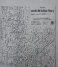
Map - Bendigo Gold Field
... Area of main goldfield: 140 square miles. Deepest mine working: 4593' (Victoria quartz). ...Area of main goldfield: 140 square miles. Deepest mine working: 4593' (Victoria quartz). ...Plan showing portion of the Bendigo goldfield. Area of main goldfield: 140 square miles. Deepest mine working: 4593' (Victoria quartz). Gold output of field to 1935: 20,775,000 ounces. Dividends paid 1870-1935: 10,740,000 pounds.map, goldfield, bendigo -
 Bendigo Historical Society Inc.
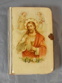
Book - German Bible
... quartz mining. German enclaves existed at Diamond Hill, New Chum Gully, Victoria Hill, Ironbark and in the Whipstick area. ...quartz mining. German enclaves existed at Diamond Hill, New Chum Gully, Victoria Hill, Ironbark and in the Whipstick area. ...There was a large influx of German miners to the Bendigo gold fields and they mainly focussed on deep quartz mining. German enclaves existed at Diamond Hill, New Chum Gully, Victoria Hill, Ironbark and in the Whipstick area. The first Lutheran Church was built in 1865 and there were also two German schools. Small bible with hard cover, possibly bakelite/plastic. The cover has an image of Jesus with and angel above each of his shoulders and plants at the bottom of the image. Pages of bible have gold edging. There is a metal clasp to lock. The back is plain and a creamy color.german, bible, religion -
 Bendigo Historical Society Inc.
Document - JOAN O'SHEA COLLECTION: VICTORIA HILL GOLDMINING AREA BOOKLET, March 1972
... Victoria Hill Bendigo Gold Mining on the Richest Quartz Reef in Bendigo, from 1854 to 1916. Colour and Black and White Booklet 16 Pages. Includes Maps of the Victoria Hill Area...Victoria Hill Bendigo Gold Mining on the Richest Quartz Reef in Bendigo, from 1854 to 1916. Colour and Black and White Booklet 16 Pages. Includes Maps of the Victoria Hill Area ...Joan O'Shea Collection. Victoria Hill Bendigo Gold Mining on the Richest Quartz Reef in Bendigo, from 1854 to 1916. Colour and Black and White Booklet 16 Pages. Includes Maps of the Victoria Hill Area, photographs of the remains of a twenty head crushing battery, burnt ground from quartz roasting, The Victoria Quartz Mine Photograph from Australian Mining Standard June 1899, The compressor beds and concrete foundations for the poppet legs all that remain today of the Victoria Quartz Mine deepest mine on Bendigo Goldfield 4613 feet or 1406.04 metres. Also included photograph of the view of Victoria Hill from The New Chum Hill in the 1870s. The Location of the 3 mines Ballerstedt's open cut, North Old Chum and Lansell's 180 are marked. A depiction of Rae's Open Cut gives an understanding of the primitive nature of early workings on the Goldfields. The Booklet also provides a brief history of Victoria Hill itself.Bendigo Trust Publication March 1972. Printed in Bendigo Cambridge Press.bendigo, mining, victoria hill -
 Bendigo Historical Society Inc.
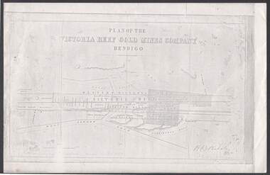
Document - VICTORIA REEF GOLD MINES COMPANY BENDIGO PLAN
... Victoria Reef Gold Mines Company, Bendigo. Shaded area is the Victoria Reef Gold Mines Company Lease No. 2 and Lease No. 3. The gullies are named Happy Valley, Long, Derwent, Providence and Ironbark Gullies. The reefs are: Western Victoria, Victoria, Eastern Victoria and Prince Albert Reef. Between the Eastern Victoria Reef and the Prince Albert Reef is the White Lead. Mount Korong Road is at the bottom of the plan. Other Leaseholders are: Burrows, Wybrant, Ballerstedt, Jackson,Roberts & Co, Ashley, Grant, ?rpe, ?eau, Woodward, Coath, Taylor, Cranshaw, Roberts, Gould & Co, Midway, Witscheibe, Endeavour Co, Albert Co, Ballerstedt & Son, Late Iron Bark Quartz...Victoria Reef Gold Mines Company Bendigo - Plan H B Nicholas Burrows Wybrant Ballerstedt Jackson Roberts & Co Ashley Grant ?rpe ?eau Woodward Coath Taylor Cra-shaw Roberts Gou-d & Co Midway Witscheibe Endeavour Co Albert Co Ballerstedt & Son Late Iron Bark Quartz Mining Co McDougall Specimen Hill Co Hyo? Wheadon Evans Bannerman. Photocopy of a Plan of the Victoria Reef Gold Mines Company, Bendigo. Shaded area ...Photocopy of a Plan of the Victoria Reef Gold Mines Company, Bendigo. Shaded area is the Victoria Reef Gold Mines Company Lease No. 2 and Lease No. 3. The gullies are named Happy Valley, Long, Derwent, Providence and Ironbark Gullies. The reefs are: Western Victoria, Victoria, Eastern Victoria and Prince Albert Reef. Between the Eastern Victoria Reef and the Prince Albert Reef is the White Lead. Mount Korong Road is at the bottom of the plan. Other Leaseholders are: Burrows, Wybrant, Ballerstedt, Jackson,Roberts & Co, Ashley, Grant, ?rpe, ?eau, Woodward, Coath, Taylor, Cranshaw, Roberts, Gould & Co, Midway, Witscheibe, Endeavour Co, Albert Co, Ballerstedt & Son, Late Iron Bark Quartz Mining Co, McDougall, Specimen Hill Co, Hygrect?, Wheadon, Evans and Bannerman. Signed by H. B. Nicholas. Location of Ballerstedt, Luffsman, Midway Co, Witscheibe and Rae & Co engine locations. Hills are shown as hatch shading. Written at the bottom left ocrner is: Accompanying prospectus issued in Nov. 1859. Signed H.B. Nicholas.plan, bendigo, victoria reef gold mines company, victoria reef gold mines company bendigo - plan, h b nicholas, burrows, wybrant, ballerstedt, jackson, roberts & co, ashley, grant, ?rpe, ?eau, woodward, coath, taylor, cra-shaw, roberts, gou-d & co, midway, witscheibe, endeavour co, albert co, ballerstedt & son, late iron bark quartz mining co, mcdougall, specimen hill co, hyo?, wheadon, evans, bannerman. -
 Bendigo Historical Society Inc.
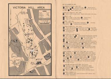
Map - VICTORIA HILL AREA
... Victoria Hill Area... Victoria Consols... New Chum anticline... Great Central Victoria... Rae's Open Cut... W Rae's Home... Victoria Quartz...Victoria Hill Area printed on yellow paper. Details of tracks, cuttings, contours (in Metres) and Anticline. Location of mines, open cuts and buildings are shown. Numbers on map are: Ballerstedt's Claim 1 - 5; North Old Chum Co. 6; Lansell's 180, 7,8,11; Battery 9.10.12; Victoria Quartz Co. 13 - 17; Rae's Open Cut and Vicinity 18 - 28, Great Central Victoria Co 29 - 36, Adventure and Advance Area and vicinity 37 - 40 and Victoria Consols Co 41....History House 11 Mackenzie Street Bendigo goldfields MAP Bendigo victoria hill Victoria Hill Area Victoria Consols New Chum anticline Great Central Victoria Rae's Open Cut W Rae's Home Victoria Quartz Ballerstedt's Open Cut Lansell's 180 North Old Chum Central Nell Gwynne John Brown Factory Gold Mines Hotel Cleopatra Needle type chimney Floyd's Battery Ballerstedt's 24yd Claim Humboldt Shaft Wittscheibe's Jeweller's Shop Luffsman and Sterry's Claim Victoria Hill Reserve Mines Dept Reervation Map of Victoria Hill Area printed on yellow paper. ...Map of Victoria Hill Area printed on yellow paper. Details of tracks, cuttings, contours (in Metres) and Anticline. Location of mines, open cuts and buildings are shown. Numbers on map are: Ballerstedt's Claim 1 - 5; North Old Chum Co. 6; Lansell's 180, 7,8,11; Battery 9.10.12; Victoria Quartz Co. 13 - 17; Rae's Open Cut and Vicinity 18 - 28, Great Central Victoria Co 29 - 36, Adventure and Advance Area and vicinity 37 - 40 and Victoria Consols Co 41.map, bendigo, victoria hill, victoria hill area, victoria consols, new chum anticline, great central victoria, rae's open cut, w rae's home, victoria quartz, ballerstedt's open cut, lansell's 180, north old chum, central nell gwynne, john brown factory, gold mines hotel, cleopatra needle type chimney, floyd's battery, ballerstedt's 24yd claim, humboldt shaft, wittscheibe's jeweller's shop, luffsman and sterry's claim, victoria hill reserve, mines dept reervation -
 Bendigo Historical Society Inc.
Document - NOTES ON BENDIGO MINES
... area of lease, yards along the reef, depth, dividends, main shafts within one mile of Bendigo Station and shafts made safe by the Mines Dept. Mines mentioned are: South New Moon, Carlisle, Nth Garden Gully, Passby, Old Carlisle,Kentish, Central Garden Gully, Golden Fleece, Garden Gully United, Big Blue, Union Co, Red, White & Blue, New Chum Railway, Unity, Cornish, Catherine Reef United, Garden Gully United, Gt Extended Hustlers, Gt Northern, Lady Barkly, New Moon, South St Mungo, Virginia and Victoria Quartz, Document from Albert Richardson Collection of mining history....History House 11 Mackenzie Street Bendigo goldfields DOCUMENT Gold notes on bendigo mines Notes on Bendigo Mines South New Moon Carlisle Nth Garden Gully Passby Old Carlisle Kentish Central Garden Gully Golden Fleece Garden Gully United Big Blue Union Co Red White & Blue New Chum Railway Unity Cornish Catherine Reef United Garden Gully United Gt Extended Hustlers Gt Northern Lady Barkly New Moon South St Mungo Virginia Victoria Quartz Graham Tenby and Ashman Mr J B Watson Geo Lansell Mines Dept D E Thomas Handwritten notes on Bendigo Mines. Notes include area ...Handwritten notes on Bendigo Mines. Notes include area of lease, yards along the reef, depth, dividends, main shafts within one mile of Bendigo Station and shafts made safe by the Mines Dept. Mines mentioned are: South New Moon, Carlisle, Nth Garden Gully, Passby, Old Carlisle,Kentish, Central Garden Gully, Golden Fleece, Garden Gully United, Big Blue, Union Co, Red, White & Blue, New Chum Railway, Unity, Cornish, Catherine Reef United, Garden Gully United, Gt Extended Hustlers, Gt Northern, Lady Barkly, New Moon, South St Mungo, Virginia and Victoria Quartz, Document from Albert Richardson Collection of mining history.document, gold, notes on bendigo mines, notes on bendigo mines, south new moon, carlisle, nth garden gully, passby, old carlisle, kentish, central garden gully, golden fleece, garden gully united, big blue, union co, red, white & blue, new chum railway, unity, cornish, catherine reef united, garden gully united, gt extended hustlers, gt northern, lady barkly, new moon, south st mungo, virginia, victoria quartz, graham, tenby and ashman, mr j b watson, geo lansell, mines dept, d e thomas -
 Bendigo Historical Society Inc.
Document - NEW CHUM & VICTORIA LINES OF REEF - THE NEW CHUM REEFS AND SOUTH VICTORIA
... History House 11 Mackenzie Street Bendigo goldfields DOCUMENT Gold New Chum & Victoria Lines of Reef The New Chum Reefs and South Victoria Dicker's 23/11/1861 Pages 7 to 9 Bonatti's Claim Gibbs & Lazarus Claim Phoenix Company South Victoria The Black Lead Messrs Ballerstedt Garibaldi's Company's Claim New Chum Company M'Dougall Inglis Menzies Dehan The White Lead New Chum Quartz Mining company Bonati and Company Phillip Bonati Woolcrow Albrecht Pragleman Mortinson Plumbreck Emmerling Sievis Denis's Claim Messrs Thompson and Powell Geo Denis Begelhole and Company Mr Begelhole Brown Blackwell Hildebrand & Co Begelhole & Co W Begelhole Thomas Brown Henry Begelhole John Blackwell Watson & Co J B Watson Gibbs Lazarus Local Court Grant Gibbs & Lazarus Claim Mr Gibbs Mr Lazarus Phoenix Company's Claim Pioneer Company Henry Jackson Sullivan Burrows Chambers Marshall William Gunther Klemin Fulton Brown Brown Anderson First Quartz Mining Company Burrow's & Co's Claim Hudson's Thomas Burrows W Philips George Hudson John Wybrant Handwritten notes on the New Chum Reefs (White & Black Leads) and South Victoria. Ref. Dicker's 23/11/1861 Pages 7 to 9. Notes include geography, Claims, Owners, Area ...Handwritten notes on the New Chum Reefs (White & Black Leads) and South Victoria. Ref. Dicker's 23/11/1861 Pages 7 to 9. Notes include geography, Claims, Owners, Area & Title, Workings, Reef and Yield, Drainage and Remarks. Dates are 13/8/1861, 16/10/1861 and 11/9/1861. Also, a typed copy is includeddocument, gold, new chum & victoria lines of reef, the new chum reefs and south victoria, dicker's 23/11/1861 pages 7 to 9, bonatti's claim, gibbs & lazarus claim, phoenix company, south victoria, the black lead, messrs ballerstedt, garibaldi's company's claim, new chum company, m'dougall, inglis, menzies, dehan, the white lead, new chum quartz mining company, bonati and company, phillip bonati, woolcrow, albrecht, pragleman, mortinson, plumbreck, emmerling, sievis, denis's claim, messrs thompson and powell, geo denis, begelhole and company, mr begelhole, brown, blackwell, hildebrand & co, begelhole & co, w begelhole, thomas brown, henry begelhole, john blackwell, watson & co, j b watson, gibbs, lazarus, local court grant, gibbs & lazarus claim, mr gibbs, mr lazarus, phoenix company's claim, pioneer company, henry jackson, sullivan, burrows, chambers, marshall, william gunther, klemin, fulton, brown, brown, anderson, first quartz mining company, burrow's & co's claim, hudson's, thomas burrows, w philips, george hudson, john wybrant -
 Bendigo Historical Society Inc.
Document - VICTORIA HILL - THE BENDIGO DIGGINGS, PRELIMINARY DRAFT FOR BROCHURE
... First part is the objective which is to preserve the mining history and to have exhibits in the places they were used, e.g. quartz mining machinery exhibited in a quartz mining area, not on an alluvial field. Part B is historical notes on the area. Part C is the Site - Victoria Hill area. ...History House 11 Mackenzie Street Bendigo goldfields BHS Collection MINING Marketing victoria hill Victoria Hill The Bendigo Diggings - Preliminary Draft for Brochure Aust National Travel Association Tullamarine Jetport Emu Bottom Homestead Kyneton Historical Museum Chinese Joss House Eaglehawk Museum Whipstick Scrub Cairn Curran Reservoir Castelmaine Historical Museum and Market Hall National Trust Ballarat Hiatorical Park Echuca's Hopwood Gardens Swan Hill Folk Museum Gibson's Mount Alexander No 2 Squatting Run Captain Brown Chief Commissioner Wright Hustler's Reef Thomas Hustler Mining Board Drainage of Reefs Act 1862 First World War Bendigo Amalgamated Goldfields Second World War Sandhurst W C Vahland Battery Trams Horse Trams Steam Trams Electric Trams Central Nell Gwynne Mine Theodore Ballerstadt George Lansell New Chum Hill Ballerstadt's Open Cut 180 Mine New Chum Syncline Battery William Rae Victoria Quartz Wittscheibe's 'Jeweller's Shop' Luffsman and Sterry Gold Mines Hotel Adventure Bendigo and District Tourist Association Bendigo City Council Bendigo Branch of the Royal Historical Society of Victoria Professor Brian Lewis School of Architecture and Building at the University of Melbourne Taylor Horsfield Lord Robert Cecil South Australian Gold Commissioner Nine typed pages of notes on a preliminary draft for a brochure on the Bendigo Diggings. First part is the objective which is to preserve the mining history and to have exhibits in the places they were used, e.g. quartz mining machinery exhibited in a quartz mining area ...BHS CollectionNine typed pages of notes on a preliminary draft for a brochure on the Bendigo Diggings. First part is the objective which is to preserve the mining history and to have exhibits in the places they were used, e.g. quartz mining machinery exhibited in a quartz mining area, not on an alluvial field. Part B is historical notes on the area. Part C is the Site - Victoria Hill area. Part D is Stage One which consists of carpark area, technological museum, restaurant, mineral haulage line, picnic ground, earthworks and planting over the area. Part E is Stage Two which will consist of the open-air exhibits, in the area surrounded by the mineral haulage line, and the Central Nell Gwynne mine on the west side of the site. Part F is Stage Three which will consist of the winery, the steam tram track, the lake, the wildlife sanctuary and various buildings associated with gold mining. Part G is Costing with the prices to be filled in. Parts H and I are the Appeal and the Committee. Details to be filled in. Notes prepared by Albert Richardson.mining, marketing, victoria hill, victoria hill, the bendigo diggings - preliminary draft for brochure, aust national travel association, tullamarine jetport, emu bottom homestead, kyneton historical museum, chinese joss house, eaglehawk museum, whipstick scrub, cairn curran reservoir, castelmaine historical museum and market hall, national trust, ballarat hiatorical park, echuca's hopwood gardens, swan hill folk museum, gibson's mount alexander no 2 squatting run, captain brown, chief commissioner wright, hustler's reef, thomas hustler, mining board, drainage of reefs act 1862, first world war, bendigo amalgamated goldfields, second world war, sandhurst, w c vahland, battery trams, horse trams, steam trams, electric trams, central nell gwynne mine, theodore ballerstadt, george lansell, new chum hill, ballerstadt's open cut, 180 mine, new chum syncline battery, william rae, victoria quartz, wittscheibe's 'jeweller's shop', luffsman and sterry, gold mines hotel, adventure, bendigo and district tourist association, bendigo city council, bendigo branch of the royal historical society of victoria, professor brian lewis, school of architecture and building at the university of melbourne, taylor horsfield, lord robert cecil, south australian gold commissioner -
 Bendigo Historical Society Inc.
Document - VICTORIA HILL - RECOMMENDATION - MINING PROJECT
... Victoria Hill Area... Big 180... Victoria Quartz...History House 11 Mackenzie Street Bendigo goldfields MINE Gold victoria hill Victoria Hill Recommendation - Mining Project Central Nell Gwynne Jack Barker Victoria Hill Area Big 180 Victoria Quartz New Chum Hill (Old Chum Hill) P. ...Two (a & b) typed copy of a recommendation for mining project, accepted Nov. 1967. Recommendation for Central Nell Gwynne area, now a public purposes reserve for preservation as a permanent reminder of the gold mining era. Victoria Hill Area mentioned for it's geographical and historical significance. The New Chum Hill area rich in historical and mining. Notes on development of the Central Nell Gwynne, Victoria Hill and New or Old Chum Hill areas. Notes prepared by Albert Richardson.mine, gold, victoria hill, victoria hill, recommendation - mining project, central nell gwynne, jack barker, victoria hill area, big 180, victoria quartz, new chum hill (old chum hill), p. m. g. repeater station, mine's department, land's department, lansell, fortuna, a h q survey regiment, lazarus mine, b c v 8 television studio -
 Bendigo Historical Society Inc.
Document - VICTORIA HILL - VICTORIA HILL HISTORY
... Victoria Hill area. Some of the mines from South to North: North Old Chum, Lansell's 'Big 180', Ballerstedt's Open - Cut, 20 Head Battery Stampers, The Victoria Quartz, Rae's Open - Cut, which has some colourful geographical features, Central Victoria (also known as the 'Midway'), Wittshiebe's 'Jeweller's Shop', Boldt's 5 Head Crushing Battery (site only), Advance Shaft, Hercules & Energetic. ...History House 11 Mackenzie Street Bendigo goldfields MINE Gold victoria hill Victoria Hill Victoria Hill History North Old Chum John Wybrandt Lansell's 'Bit 180' T Ballerstedt Wittschiebe Fortuna Villa Geo Lansell A H Q Survey Regiment Ballerstedt's Open Cut Victoria Quartz (Victoria Reef Quartz) Rae's Open Cut Wm Rae Gt Central Victoria (Midway) Adventure Wittshiebe's 'Jeweller's Shop' Boldt's 5 Head Crushing Battery Advance Cinderella Hercules & Energetic John Brown Knitwear Factory A Richardson Hand written notes and typed copy of the history of Victoria Hill area. ...Hand written notes and typed copy of the history of Victoria Hill area. Some of the mines from South to North: North Old Chum, Lansell's 'Big 180', Ballerstedt's Open - Cut, 20 Head Battery Stampers, The Victoria Quartz, Rae's Open - Cut, which has some colourful geographical features, Central Victoria (also known as the 'Midway'), Wittshiebe's 'Jeweller's Shop', Boldt's 5 Head Crushing Battery (site only), Advance Shaft, Hercules & Energetic. Notes prepared by Albert Richardson.mine, gold, victoria hill, victoria hill, victoria hill history, north old chum, john wybrandt, lansell's 'bit 180', t ballerstedt, wittschiebe, fortuna villa, geo lansell, a h q survey regiment, ballerstedt's open cut, victoria quartz (victoria reef quartz), rae's open cut, wm rae, gt central victoria (midway), adventure, wittshiebe's 'jeweller's shop', boldt's 5 head crushing battery, advance, cinderella, hercules & energetic, john brown knitwear factory, a richardson