
Showing 19 items matching " wesleyan school-house"
-
 Bendigo Historical Society Inc.
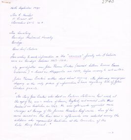
Document - CORRESPONDENCE TO BHS RE: CROCKER FAMILY
... ... Wesleyan School-House...Crocke who attended the opening service of the Wesleyan School-house, situated at View Point Sandhurst....Crocke who attended the opening service of the Wesleyan School-house, situated at View Point Sandhurst. ...Correspondence to BHS re Crocker family - lived in Bendigo 1869 - 1912. Manager - Hustlers Reef mine. Reply from BHS: ''1891 - Mr Crocker was a member of the Mining Board''. A bracketed comment makes reference that the Mr. Crocker referred to in this letter may not have been the to which you refer. The reply make reference to a Mr. Crocke who attended the opening service of the Wesleyan School-house, situated at View Point Sandhurst.person, individual, crocker family, james thomas croker, king edwards, hustlers reef mine, mining board, wesleyan school-house, view point sandhurst. -
 Flagstaff Hill Maritime Museum and Village
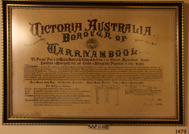
Document - Framed Poster, Borough of Warrnambool, Victoria, Australia, after 30/06/1875
... Houses in Borough 800. Public Buildings and Institutions Churches. Church of England, Roman Catholic, Presbyterian, Wesleyan, Congregational and Baptist. Schools...Houses in Borough 800. Public Buildings and Institutions Churches. Church of England, Roman Catholic, Presbyterian, Wesleyan, Congregational and Baptist. Schools ...This document, also referred to as a word picture or Tablet, is framed in glass and timber with gilt trim, is handwritten with colour highlights. The penned letters rest on ruled guide lines, decorated where the lines intersect. The writing gives a description of the state of Borough of Warrnambool around 1875; its location, the area it covers, its population, Harbour and facilities, public buildings and institutions, imports and exports, financial worth, number of houses, connection with other areas of the Colony. A possible reason and origin for the document is found in an article ‘Link with US Exhibition’ from the Warrnambool Standard of December 19, 1981, written by local historian Bruce Morris. The writer mentions that the Warrnambool Borough Council met on 15th June 1875 and recorded a letter from G.C. Levey , secretary to the Melbourne group of commissioners representing the Colony, and Victoria in particular, for the Philadelphia Centennial Exhibition of 1876. The letter asks Council to provide “statistics as to the population, social condition and commercial and industrial state of the district in and around Warrnambool.” A sub committee was formed for the project. The Mayor, Cr. Thomas King, wrote and signed a Report, presented to the council on July 14, 1875, in which “The Committee … begs to recommend that a Tablet be prepared setting for the particulars respecting the following matters relating to the Borough”. The matters included area, population, annual income, churches, schools, other public buildings, societies and companies, general description of houses erected, and returns of exports and imports for 1874. The minutes note that the Report was adopted. The article above also notes the opinion of Warrnambool printers who have examined the document; it is almost certainly to be an old lithograph, which means there could be several copies. It is possible that there may be a copy in Melbourne and another in Philadelphia. It is interesting to note that (1) the quoted location co-ordinates are for an “Unnamed Road, Packsaddle NSW 2880, Australia”, and that the DMS co-ordinates for Warrnambool’s Council Offices differ, being 38.23.9.12 South, 142.28.52.887. (2) the date for “Exports and Imports for the Year Ending 30th June 1875” is different to the period mentioned by Cr. King in the sub committee’s Report of recommendation “returns of exports and imports for 1874”. The information required to have the figures for the end of June 1875 would need to have been compiled very quickly for the Tablet to be ready for the opening of the Philadelphia Exhibition on 10 May 1876. The document/certificate shows the following – - - - - - - - - - - - - - - -- - - - - - - - - - - - - - -- - - - - - - - - - - - - - -- - - - - - - - - - - - - - - “Victoria Australia, Borough of Warrnambool. Latitude, 30.24.50 South, Longitude 142.32 East The Principal Port in the Western District of the Colony and the Centre of its Choicest Agricultural Lands. Established a Municipality in 1855, and Created a Borough 1863. Population in 1875 4,500. Warrnambool is the nearest Port to Melbourne on the Western Seaboard, being about 160 miles distant. Coaches run to and from the Metropolis daily, in connexion [connection] with the Railway of Geelong and Steamers belonging to Local Companies sail between Melbourne, Warrnambool, Belfast [renamed Port Fairy], and Portland several times weekly. The Harbour is known as Lady Bay, and is partially protected by a reef of rocks stretching from the mouth of the Hopkins River. The formation of a Breakwater has been decided upon by the Government, to extend 600 yards, at an estimated cost of £100,000. There are two substantial Jetties, one of 800 and the other of 600 feet in length. The former is connected with the Town by means of a Tramroad, along which Goods, inwards & outwards, are conveyed, & the latter has been constructed solely for the purpose of facilitating the transit of material for the formation of the Breakwater. In addition to the trade of the Borough and District, the principal Townships up country receive their supplies from Melbourne and ship their exports through Warrnambool. Potatoes form the staple produce of the district, and the richness of the soil can be estimated by the fact that the Government Statistics for 1875 give as the average yield a return of Seven Tons to the acre. Several thousand acres between Warrnambool and Tower Hill are now being laid down in Potatoes by Tenants who have leased the lands at rates up to £5 per acre for the season 1875-6. Wool, Tallow, hides &c are also largely exported, while the shipments of all descriptions of Farm Produce are annually increasing. Area of Borough, 3362 Acres. Net Annual Value £27,000. Annual Revenue £5,500. Number of Houses in Borough 800. Public Buildings and Institutions Churches. Church of England, Roman Catholic, Presbyterian, Wesleyan, Congregational and Baptist. Schools. Three State Schools, average attendance nearly 1000. New Building in course of erection. Several private establishments. Banks. Bank of Australasia, Bank of Victoria, National Bank, Colonial Bank and Savings Bank. Public Buildings. Court house, Custom house, Post & Telegraph Offices, Survey & Land Offices, Shire £, Town Hall, Mechanics Institute, Volunteer Orderly Room, Odd Fellows Hall, Hospital & Benevolent Asylum, Temperance Hall &c. Companies & Societies. Steam Navigation Co, Woolen Mill Co, Gas Co, Racing Club, Amateur Turf Club, Agricultural Society, Farmers’ Club, Cricket Club, Anglers’ Society, Building Society, Freemasons Odd Fellows, Foresters, Druids, Hibernians. Protestant Alliance, Rechabites, Sons of Temperance, &c, Fire Brigade &c. --- Exports and Imports for the Year Ending 30th June 1875 –-- --Exports Total Tonnage 27,800 (Calculated at the Current Warrnambool Market Prices) Potatoes Wool Wheat Barley Hides Skins Fowls Butter Cheese Eggs Tallow Leather Ale Pigs Sheep Sundries --Imports 13,000 Tons Of the Estimated Value of £520,000 Total Tonnage of Exports and Imports 40m900 Tons, Value £806,627 Passenger Travels, to ad from Warrnambool during year, 10,000 persons Revenue from all sources paid through Warrnambool Sub Treasury From 1860 to June 1875 £1, 292, 300 Thomas King [signed] Mayor Henry T Read [signed] Town Clerk” - - - - - - - - - - - - - - -- - - - - - - - - - - - - - -- - - - - - - - - - - - - - -- - - - - - - - - - - - - - - The document is of historical, social, economic and local significance in that it summarises activities, business, community, trade, travel and government at a point in time in Warrnambool’s history – 30th June 1875.Document, also referred to as a ‘word picture’ or ‘tablet’. Document is framed in glass and timber with gilt trim, handwritten with colour highlights. The penned letters rest on ruled guide lines, decorated where the lines intersect. Document outlines the establishment of Warrnambool as a Municipality in 1855 and Borough in 1863, with a population of 4,500 in 1875. It states geographic location, public buildings and institutions, harbor facilities and imports and exports for the year ending 30th June 1875. Two signatures "Thomas King" Mayor and "Henry T Read" Town Clerk. It shows the Coat of Arms of the Borough of Warrnambool.Signatures - "Thomas King" Mayor and "Henry T Read" Town Clerk. Warrnambool Coat of Arms; “British Coat of Arms, above sailing vessel and sheaf of wheat in sun, motto “By these we flourish” and around circumference “Borough of Warrnambool 1855”flagstaff hill, warrnambool, shipwrecked coast, flagstaff hill maritime museum, maritime museum, shipwreck coast, flagstaff hill maritime village, great ocean road, borough of warrnambool, municipality of warrnambool, document borough of warrnambool 1875, word picture of warrnambool 1875, tablet of borough of warrnambool 1875, statistics borough of warrnambool 1875, lithograph borough of warrnambool 1875, coat of arms warrnambool, warrnambool city motto – in these we flourish, establishment of warrnambool, warrnambool history, thomas king mayor of warrnambool, henry t read town clerk of warrnambool, warrnambool breakwater, warrnambool jetty, warrnambool imports and exports 1875, warrnambool agriculture 1875, warrnambool business 1875, warrnambool population 1875, centennial exhibition philadelphia 1876, framed certificate -
 Federation University Historical Collection
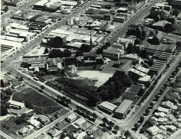
Photograph - Black and White, Aerial View of the Ballarat School of Mines
... school...administration building...former wesleyan church...former court house...The photograph shows the Corbould Building, tennis court, Model Mine, Ballarat Junior Technical School, Administration Building, former Wesleyan Church, Former Court House, Former Ballarat Gaol walls, Old Plumbing Building, Old Chemistry Building, Botanical Gardens, Corbould Hall, Ballarat Brewery, Ballarat Girls' School, Albert Street, Grant Street, Hickman Street...corbould building ballarat school of mines tennis court model mine ballarat junior technical school administration building former wesleyan church former court house former ballarat gaol walls old plumbing building old chemistry building botanical gardens corbould hall ballarat brewery ballarat girls' school albert street grant street hickman street flecknoe Aerial photograph of the Ballarat School of Mines soon after the Ballarat Gaol was demolished. ...Aerial photograph of the Ballarat School of Mines soon after the Ballarat Gaol was demolished. The photograph shows the Corbould Building, tennis court, Model Mine, Ballarat Junior Technical School, Administration Building, former Wesleyan Church, Former Court House, Former Ballarat Gaol walls, Old Plumbing Building, Old Chemistry Building, Botanical Gardens, Corbould Hall, Ballarat Brewery, Ballarat Girls' School, Albert Street, Grant Street, Hickman Streetcorbould building, ballarat school of mines tennis court, model mine, ballarat junior technical school, administration building, former wesleyan church, former court house, former ballarat gaol walls, old plumbing building, old chemistry building, botanical gardens, corbould hall, ballarat brewery, ballarat girls' school, albert street, grant street, hickman street, flecknoe -
 Federation University Historical Collection
Book - Report, Ballarat School of Mines Conservation Management Plan, 2016, 2016
... Contents include: Establishment of the Wesleyan church Reserve Selection of a Site for the Ballarat Gaol and Court House Building the Court of Mines The Gaol Culvert The Ballarat School of Mines Establishment Ballarat iron Workers' Association Ballarat Technical Art School Ballarat School of Mines Museum Acquisition of Lewin's Land The Ballarat School of Mines site in c1970 Master Planning Flecknoe Biulding The Ballarat School of Mines in 1988 Architectects Caselli, Figgus, Molloy and Smith. ...The Ballarat School of Mines was the first school of mines in Australasia, and is a predecessor institution of Federation University Australia. david rowe wendy jacobs ballarat school of mines conservation management plan ballarat school of mines buildings wesleyan church reserve former ballarat gaol court of mines circuit courthouse gal culvert ballarat school of mines museum ballarat technical art school x-rays ballarat junior technical school motor mechanics wool classing former governor's quarters library flecknoe building former supreme court architects henry richards caselli figgis molloy and smith public work department architects ballarat school of mines botanic garden former ballarat junior technical school commemorative gardem w.j. gribble building old chemistry building amenities building former warden's quarters courthouse theatre a.w. steane building old plumbing building unistyle hairdressing building former ballarat post office post office gallery former ballarat government offices CMP Conservation management plan Ballarat School of Mines Campus SMB Campus CD-ROM of the SMB Campus Conservation Management plan, and a printout of the 390 page Draft report on the Federation University SMB Campus. Contents include: Establishment of the Wesleyan church Reserve Selection of a Site for the Ballarat Gaol and Court House Building the Court of Mines The Gaol Culvert The Ballarat School of Mines Establishment Ballarat iron Workers' Association Ballarat Technical Art School Ballarat School of Mines Museum Acquisition of Lewin's Land The Ballarat School of Mines site in c1970 Master Planning Flecknoe Biulding The Ballarat School of Mines in 1988 Architectects Caselli, Figgus, Molloy and Smith. ...The Ballarat School of Mines was the first school of mines in Australasia, and is a predecessor institution of Federation University Australia.CD-ROM of the SMB Campus Conservation Management plan, and a printout of the 390 page Draft report on the Federation University SMB Campus. Contents include: Establishment of the Wesleyan church Reserve Selection of a Site for the Ballarat Gaol and Court House Building the Court of Mines The Gaol Culvert The Ballarat School of Mines Establishment Ballarat iron Workers' Association Ballarat Technical Art School Ballarat School of Mines Museum Acquisition of Lewin's Land The Ballarat School of Mines site in c1970 Master Planning Flecknoe Biulding The Ballarat School of Mines in 1988 Architectects Caselli, Figgus, Molloy and Smith. Public Work Department Architects Ballarat School of Mines Botanical Garden Former Ballarat Junior Technical School Administration Building - Building A W.J. Gribble Building (Ballarat Technical Art School) - Building B Old Chemistry Building Building C Amenities Building, Governor's Quarters, Gaol Gatehouse and Watch Tower and Gaol Walls - Building D Courthouse Theatre (Former Ballarat Supreme Court) - Building F A.W. Steane Building (Former Ballarat Junior Technical School) - Building J Flecknoe Building and E.J. Barker Building (Building N) Old Plumbing Building - Builidng ) Unistyle Haridressing Building (Formerly Ballarat School of Mines Museum and Wesleyan Church) - Building P david rowe, wendy jacobs, ballarat school of mines conservation management plan, ballarat school of mines, buildings, wesleyan church reserve, former ballarat gaol, court of mines, circuit courthouse, gal culvert, ballarat school of mines museum, ballarat technical art school, x-rays, ballarat junior technical school, motor mechanics, wool classing, former governor's quarters, library, flecknoe building, former supreme court, architects, henry richards caselli, figgis, molloy and smith, public work department architects, ballarat school of mines botanic garden, former ballarat junior technical school commemorative gardem, w.j. gribble building, old chemistry building, amenities building, former warden's quarters, courthouse theatre, a.w. steane building, old plumbing building, unistyle hairdressing building, former ballarat post office, post office gallery, former ballarat government offices, cmp, conservation management plan, ballarat school of mines campus, smb campus -
Federation University Historical Collection
Booklet - Walking Guide, Ballarat Heritage Walking Guide, c2015
... House...Pratt's Building...YMCA...Ballarat Trades Hall...ANA Hall...maps...Lydiard Street...Ballarat Gaol...Ballarat School of Mines...Wesleyan...Ballarat Walking trail Statues Gold Monument Sturt Street unicorn hotel Ballarat Town hall Sugg light Ballarat Post Office Camp Street Summerscales Building State Offices Police court Huyghue House Pratt's Building YMCA Ballarat Trades Hall ANA Hall maps Lydiard Street Ballarat Gaol Ballarat School of Mines Wesleyan Church Ansonia Lynn's Chambers Craig's Royal Hotel her Majesty's Theatre Union Bank Building Bank of Australasia National Bank Colonial Bank of Australasia Bank of New South Wales George Hotel Old Colonists' hall Art Gallery of Ballarat Union Fidelity Hall Goller's Warehouse Dunn's Warehouse Ludbrook House Reid's Coffe Police Ballarat Railway Station Cenotaph Queen Victoria Fountain Boer War Memorial Burke and Wills Founitain Titanic Memorial Bandstand 35 page booklet with a detail from the Mining Exchange on the front. ...35 page booklet with a detail from the Mining Exchange on the front. ballarat, walking trail, statues, gold monument, sturt street, unicorn hotel, ballarat town hall, sugg light, ballarat post office, camp street, summerscales building, state offices, police court, huyghue house, pratt's building, ymca, ballarat trades hall, ana hall, maps, lydiard street, ballarat gaol, ballarat school of mines, wesleyan church, ansonia, lynn's chambers, craig's royal hotel, her majesty's theatre, union bank building, bank of australasia, national bank, colonial bank of australasia, bank of new south wales, george hotel, old colonists' hall, art gallery of ballarat, union fidelity hall, goller's warehouse, dunn's warehouse, ludbrook house, reid's coffe police, ballarat railway station, cenotaph, queen victoria fountain, boer war memorial, burke and wills founitain, titanic memorial bandstand -
 Federation University Historical Collection
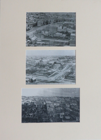
Photographs, Three Reproductions of Early SMB buildings, 01) - .2) 1872 .3) 1948
... house...former wesleyan church...Ballarat School...black and white photography smb campus lydiard street south ballarat old court house former wesleyan church Ballarat School of Mines Dana Street hill Three mounted black and white reproduction photographs depicting early SMB buildings .1) View of Ballarat Gaol, Old Court House and Wesley Church .2) Lydiard St South .3) SMB buildings 75 years later Three Reproductions of Early SMB buildings Photographs ...Three mounted black and white reproduction photographs depicting early SMB buildings .1) View of Ballarat Gaol, Old Court House and Wesley Church .2) Lydiard St South .3) SMB buildings 75 years laterblack and white photography, smb campus, lydiard street south, ballarat old court house, former wesleyan church, ballarat school of mines, dana street hill -
 Federation University Historical Collection
Photograph - Photograph - Black and White, Ballarat School of Mines, c1980s, c1910
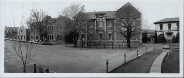
... school of mines museum former wesleyan church lydiard street south ballarat technical art school governor's residence Ballarat School of Mines from Lydiard Street South. From left to right - the Ballarat Uniting Church, School of Mines Museum (Former Wesleyan Church), New Classrooms and Administration Building, Ballarat Technical Art School, Gaol Governor's residence. Ballarat School of Mines, c1980s Photograph Photograph - Black and White Harris House ...The Ballarat School of Mines was estabished in 1870, making it the first site of technical education in Australia. Ballarat School of Mines from Lydiard Street South. From left to right - the Ballarat Uniting Church, School of Mines Museum (Former Wesleyan Church), New Classrooms and Administration Building, Ballarat Technical Art School, Gaol Governor's residence.ballarat school of mines, ballarat school of mines museum, former wesleyan church, lydiard street south, ballarat technical art school, governor's residence -
 Eltham District Historical Society Inc
Document - Property Binder, 801 Main Road, Eltham
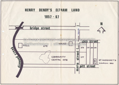
... House...Mrs Morris shop...Our Lady Help of Christian’s Primary School...Panther Place...Pitt Street...Prior Street...Shillinglaw Cottage...shops...Stones Mixed shop...Websters House...Wesleyan...Main Road Eltham Eltham Community Centre Henry Dendy Eltham Reception and Conference Centre Bill Baker Sidney Brown blacksmith Tme capsule Arthur Street Babe Taylor House bakery Boarding house Bradley House Bridge Street Brown Blacksmith Burgoyne's Shop Cockcrofts Store Commercial Bank of Australasia David Lyon house Davis Dr Cordner Dr Hall Dudley Street eltham hotel Eltham Obelisk Eltham War Memorial Garnet Burges Graham Hawker henry street John Lyon Len Perron Luck Street Lyons Garage Map Mechanics Insitute Monteith House Mrs Morris shop Our Lady Help of Christian’s Primary School Panther Place Pitt Street Prior Street Shillinglaw Cottage shops Stones Mixed shop Websters House Wesleyan Methodist Church York Street Miscellaneous clippings, notes, photocopies, etc held on the subject property. 801 Main Road, Eltham Document Property Binder ...1. Plan: Henry Dendy's Eltham Land 1857-1867: showing Diamond Creek, Bridge Street, Maria Street now Main Road, John Street, Pitt Street, St Margaret's Church 1861, and Eltham Community Centre 1987. 2. Photocopy extract from "Henry Dendy and his emigrants" by L A Schumer, re Portions 12 and 13, Parish of Nillumbik. 3. The President and Councillors of the Shire of Eltham request the pleasure of ____ at the Official Opening of the Eltham Community Centre, Cnr Main Road and Pitt Street, Eltham by the Honorable R.J. Hamer E.D., M.P., Premier of Victoria on Saturday, 22nd April, 1978 at 3.30pm 4. Souvenir Program, Opening of Eltham Community Centre 22 April 1975. 5. Invitation to attend Official Opening of Eltham Community Centre by R J Hamer, Premier of Victoria, 22 April 1975. 6. Flier for Eltham Reception and Conference Centre, photographs of interiors during events. 7. Newspaper article: Eltham buries present for the future, Diamond Valley News 19 November 1985 Eltham, photograph of burying time capsule outside Eltham Community Centre, photograph of Bill Baker and Sid Brown outside old blacksmith shop the original site of Eltham town centre. 8. Letter Peter Butler Shire of Eltham to Eltham District Historical Society, 6 July 1987, detailing process for naming of the halls at the Eltham Community Centre.6 July 1987. 9. Plan of Main Road Eltham - it depicts buildings and occupiers from Pitt Street to Luck Street in the first half of the 20th century. This plan was compiled as a joint efforts by members of the Shire of Eltham Historical Society at a general meeting in Eltham during the 1980s. Newspaper article: Swimming pool and community centre receive major revamps, Diamond Valley Leader, 21 October 2015.main road, eltham, eltham community centre, henry dendy, eltham reception and conference centre, bill baker, sidney brown blacksmith, tme capsule, arthur street, babe taylor house, bakery, boarding house, bradley house, bridge street, brown blacksmith, burgoyne's shop, cockcrofts store, commercial bank of australasia, david lyon house, davis, dr cordner, dr hall, dudley street, eltham hotel, eltham obelisk, eltham war memorial, garnet burges, graham, hawker, henry street, john lyon, len perron, luck street, lyons garage, map, mechanics insitute, monteith house, mrs morris shop, our lady help of christian’s primary school, panther place, pitt street, prior street, shillinglaw cottage, shops, stones mixed shop, websters house, wesleyan methodist church, york street -
 Eltham District Historical Society Inc
Photograph, Peter Pidgeon, Grave of David George and Elizabeth Clark, Eltham Cemetery, Victoria, 5 April 2021
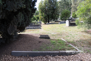
... school and built the house "Shoestring" (which still exists albeit with significant modifications). Catherine retired in 1887 followed by David in 1889 after a period of ill health and was succeeded as Head Teacher by John Brown. David died in 1911 and is buried with his wife Elizabeth in Eltham Cemetery. In Loving Memory Of D. G. & E. Clark eltham cemetery gravestones david george clark elizabeth clark Eltham Primary School Eltham Wesleyan ...David George Clark was the first and longest-serving headmaster at Eltham State School No. 209 (Eltham Primary) in Dalton Street, Eltham. David (then aged 26) and his sister Catherine first established their ‘private’ school which began in 1855 and was held in the Wesleyan Chapel in Henry Street, a slab built, shed-like building on land acquired by the Church in January 1855. Parents lobbied the Government to establish an official school, and a School Inspector came out to investigate. He found that the Clarks were of good moral and religious character (David taught Sunday School at St. Margaret's later on) and gave them his endorsement despite some perceived technical shortcomings. In 1856 a small stone building of 40 feet by 16 feet was erected on the school's present site at the corner of Main Road and Dalton Street. Half of the building was the school, the other half was the residence of David and Catherine and their mother, also Catherine. It appears that they were well respected by the local community: David constantly battled with the authorities to have facilities (such as toilets) at the school improved. As enrolment gradually increased, over-crowding became an issue. As well, David married Elizabeth in 1863. Needing to move out of the schoolhouse, in 1866 the Clarks bought a block of land in Metery Road next to the school and built the house "Shoestring" (which still exists albeit with significant modifications). Catherine retired in 1887 followed by David in 1889 after a period of ill health and was succeeded as Head Teacher by John Brown. David died in 1911 and is buried with his wife Elizabeth in Eltham Cemetery. In Loving Memory Of D. G. & E. ClarkBorn Digitaleltham cemetery, gravestones, david george clark, elizabeth clark, eltham primary school, eltham wesleyan chapel, state school no. 209 -
 Eltham District Historical Society Inc
Photograph - Digital Photograph, Alan King, Shillinglaw Cottage, 6 January 2008
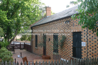
... Wesleyan Church.3 In the 1870s he is recorded as the owner of up to five houses. Earlier he had been described as a bricklayer and later became a farmer. In 1882 Stebbing returned to the Pitt Street house and Shillinglaw occupied the new house in Main Road, which he owned from 1887. Shillinglaw was a prolific poet and preached at the Eltham Primitive Methodist Church, where he also served as Sunday School...Wesleyan Church.3 In the 1870s he is recorded as the owner of up to five houses. Earlier he had been described as a bricklayer and later became a farmer. In 1882 Stebbing returned to the Pitt Street house and Shillinglaw occupied the new house in Main Road, which he owned from 1887. Shillinglaw was a prolific poet and preached at the Eltham Primitive Methodist Church, where he also served as Sunday School ...Covered under National Estate, National Trust of Australia (Victoria) Local Significance and Heritage Overlay, Nillumbik Planning Scheme. Published: Nillumbik Now and Then / Marguerite Marshall 2008; photographs Alan King with Marguerite Marshall.; p95 Thanks to an Australia first effort by local residents, the historic Shillinglaw Cottage still survives. The cottage at Panther Place, Eltham, once stood about 100 metres away on Main Road. But in 1963 it faced demolition to make room for the Eltham Shire Offices (since demolished). However residents rallied to save Shillinglaw Cottage and became the first in Australia to remove and reconstruct an early settler’s brick building. A fundraiser was the residents’ compilation of loved recipes into the cookery book, Flavour of Eltham. The cottage, built in the late 1870s by noted pioneer builder George Stebbing, is one of Eltham’s earliest buildings and associated with significant early settlers. It is on the National Estate and National Trust Registers. The cottage was constructed with handmade bricks in the Flemish Bond style, typical of cottages and farmhouses in Flanders, Europe. It features burnt ‘header’ bricks over the façade, which gives a chequered effect. The roof is made of slate, while the windows are 12-paned sash with relieving arches. It is not clear who were the first owners of the cottage. The National Trust claims that Stebbing built it for farmer Thomas Cochrane.1 Others say Cochrane first owned the land but Stebbing was Shillinglaw’s first owner and remained so until 1887. The Shillinglaw family then bought it and lived there for around 80 years until 1963 when they sold it to the Eltham Council.2 Farmer Thomas Cochrane bought the Shillinglaw Cottage site from land developer Josiah Holloway. The site was the largest in what Holloway called Little Eltham, of some 30 acres (12 ha), extending along the creek from Henry Street to Luck Street. In 1874 Cochrane sold the land to George Stebbing. Meanwhile in 1861, Stebbing was the owner and occupier of a house at Pitt Street, Eltham, which he had built. Evelyn Observer journalist James Rossiter rented the Pitt Street house, then in 1881 Phillip Shillinglaw occupied it. Stebbing constructed several buildings of note in the area, including the Uniting Church at John Street, the building beside it – a former bank – and St Margaret’s Church of England in Pitt Street. Stebbing was also an Eltham Shire Councillor from 1871 to 1873 and a trustee and treasurer of the Eltham Wesleyan Church.3 In the 1870s he is recorded as the owner of up to five houses. Earlier he had been described as a bricklayer and later became a farmer. In 1882 Stebbing returned to the Pitt Street house and Shillinglaw occupied the new house in Main Road, which he owned from 1887. Shillinglaw was a prolific poet and preached at the Eltham Primitive Methodist Church, where he also served as Sunday School superintendent and led the Young People’s Society Christian Endeavour. The Shillinglaws saw many changes in their property’s boundaries – the major one occurring at the turn of the century when land for the railway and Eltham station was acquired from their holding. The northern part of the remaining land was then used for some of the first commercial developments in what was to become the Eltham Shopping Centre. Later still, the land immediately north of the cottage was bought by the Eltham War Memorial Trust for the War Memorial Buildings and the fire station. The Trust’s land eventually passed to the council. The council bought the remaining two acres (0.8 ha) with the house, and with the exception of the commercial development between the fire station and the post office, all of the former Shillinglaw land is owned by the council or government instrumentalities.4 Since the late 20th century, the cottage has had varied uses, such as a handcrafts store and as a restaurant.This collection of almost 130 photos about places and people within the Shire of Nillumbik, an urban and rural municipality in Melbourne's north, contributes to an understanding of the history of the Shire. Published in 2008 immediately prior to the Black Saturday bushfires of February 7, 2009, it documents sites that were impacted, and in some cases destroyed by the fires. It includes photographs taken especially for the publication, creating a unique time capsule representing the Shire in the early 21st century. It remains the most recent comprehenesive publication devoted to the Shire's history connecting local residents to the past. nillumbik now and then (marshall-king) collection, shillinglaw cottage -
 Buninyong & District Historical Society
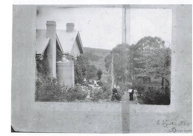
Photograph - Copy of original photograph, Copy of photograph of John Porter and family in the garden at "Fernbank"
... John Porter was a school teacher in the district for a number of years and then became Secretary of the Butter Factory and bought Fernbank in the late 1800s. The house was located in Lal Lal Street, Strawberry Glen John Porter was a well known, teacher, businessman and Wesleyan church member and head of a large well regarded family of the district School teacher Fernbank Porter Family Strawberry Glen E. ...John Porter was a school teacher in the district for a number of years and then became Secretary of the Butter Factory and bought Fernbank in the late 1800s. The house was located in Lal Lal Street, Strawberry Glen John Porter was a well known, teacher, businessman and Wesleyan church member and head of a large well regarded family of the districtCopy of photograph of John Porter and family outside "Fernbank" circa 1900 showing Strawberry Glen in the backgroundE. Poynton Photo, Buninyongschool teacher, fernbank, porter family, strawberry glen -
 Bendigo Historical Society Inc.
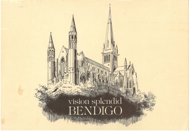
Book - VISION SPLENDID BENDIGO, 1986
... Vision Splendid Introduction, Wesleyan Church Golden Square, Sacred Heart Cathedral, Central Deborah Mine, Marlborough House, Fuse factory, Goldmines Hotel, Fortuna Villa, Bon Accord, Heinz Butcher Shop, Long Gully State School, California Gully State School, Stone cottage Harvey Town, Eaglehawk Town Hall, Caradon, Eaglehawk State School, Victoria Hotel, Bendigo Pottery, Eucalyptus Distillery, St Luke’s, Lake Weeroona, Joss House, Benevolent Home, Lansellstowe, Kaithness, Malmo Valentine Street, Dudley House, Rifle Brigade Hotel, Fire Station, Masonic Hall, Temperance Hall, Old Post Office, Wesley Church, St. ...Vision Splendid Introduction, Wesleyan Church Golden Square, Sacred Heart Cathedral, Central Deborah Mine, Marlborough House, Fuse factory, Goldmines Hotel, Fortuna Villa, Bon Accord, Heinz Butcher Shop, Long Gully State School, California Gully State School, Stone cottage Harvey Town, Eaglehawk Town Hall, Caradon, Eaglehawk State School, Victoria Hotel, Bendigo Pottery, Eucalyptus Distillery, St Luke’s, Lake Weeroona, Joss House, Benevolent Home, Lansellstowe, Kaithness, Malmo Valentine Street, Dudley House, Rifle Brigade Hotel, Fire Station, Masonic Hall, Temperance Hall, Old Post Office, Wesley Church, St. ...Vision Splendid Bendigo. Cream coloured paper 56 pages, with line drawings of landmark buildings of Bendigo. Drawings by Jan Neil. Vision Splendid Introduction, Wesleyan Church Golden Square, Sacred Heart Cathedral, Central Deborah Mine, Marlborough House, Fuse factory, Goldmines Hotel, Fortuna Villa, Bon Accord, Heinz Butcher Shop, Long Gully State School, California Gully State School, Stone cottage Harvey Town, Eaglehawk Town Hall, Caradon, Eaglehawk State School, Victoria Hotel, Bendigo Pottery, Eucalyptus Distillery, St Luke’s, Lake Weeroona, Joss House, Benevolent Home, Lansellstowe, Kaithness, Malmo Valentine Street, Dudley House, Rifle Brigade Hotel, Fire Station, Masonic Hall, Temperance Hall, Old Post Office, Wesley Church, St. John’s Church, Alexandra Fountain, Commercial Bank View Point, State Bank, St Paul’s Cathedral Railway Station, National Bank, Town Hall, Post Office, Shamrock Hotel, Camp Hill State School, Police Barracks, Law Courts, Specimen Cottage, Technical College, St. Kilian’s Church, Tram Depot, St. Aidan’s OrphanageJan Neilbendigo, buildings, heritage buildings, heritage, heritage buildings, bendigo. -
 Uniting Church Archives - Synod of Victoria
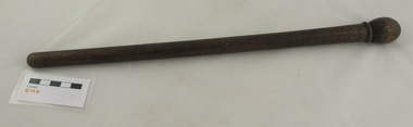
Tool - Music baton
... Houses were scarce and to reach the Wesleyan Methodist Church in Were Street, Brighton Beach a creek which had no bridge had “to be crossed – in winter, with the help of a hurricane lamp – and it was no uncommon thing for the preacher, if he were a stranger, to arrive late and breathless, or not at all.” In 1907 permission was given to form a tennis club at Were Street and Mr Herring was its first president. He was also the Were street Methodist Sunday School...Houses were scarce and to reach the Wesleyan Methodist Church in Were Street, Brighton Beach a creek which had no bridge had “to be crossed – in winter, with the help of a hurricane lamp – and it was no uncommon thing for the preacher, if he were a stranger, to arrive late and breathless, or not at all.” In 1907 permission was given to form a tennis club at Were Street and Mr Herring was its first president. He was also the Were street Methodist Sunday School ...W E Herring and his wife arrived in Brighton in 1887 to live in Roslyn Street. They had both been active members of the Fitzroy Street, St Kilda church choir. In 1937 Mr Herring recalled church life in the 1880s and 1890s. Houses were scarce and to reach the Wesleyan Methodist Church in Were Street, Brighton Beach a creek which had no bridge had “to be crossed – in winter, with the help of a hurricane lamp – and it was no uncommon thing for the preacher, if he were a stranger, to arrive late and breathless, or not at all.” In 1907 permission was given to form a tennis club at Were Street and Mr Herring was its first president. He was also the Were street Methodist Sunday School Superintendent, the Were street Methodist church organist and a member of the church’s Trust. “The Sunday School had a fine set of teachers. The rows of well-drilled and disciplined young life that filled the platform on Sunday School anniversaries, and sang their songs under the baton of Mr Herring, constituted a promise that was amply fulfilled as the years rolled on.”* *”Fifty years ago : a little history of Were Street Methodist Church” : Issued in commemoration of its Jubilee by Members of the Trust 1887 – 1937. To celebrate Queen Victoria's Diamond Jubilee Mr Herring composed an anthem. The Brighton Southern Cross, Saturday 26 June 1897, page 2 reported: "The diamond jubilee has been instrumental in evoking some local musical talent. Mr W. E. Herring, organist of the Were-street Wesleyan Church, not being able to find any anthem specially suitable to the jubilee services, set his musical genius to work and composed an original piece. The words are selected from the 72nd Psalm. The music is a very tuneful and well harmonised theme, which does credit to the composer's skill and taste. The anthem was rendered twice on Jubilee Sunday at the Were street Church." Stained wood turned music baton.w e herring, were street methodist sunday school superintendent, music baton, were street wesleyan methodist church -
 Sunshine and District Historical Society Incorporated
Administrative record - City of Sunshine - Commissioner Mr Alexander Alex George Gillon Collection 1976 - 1982 - Minutes of the ordinary meeting of council held on 15th June 1977, City of Sunshine, 1th June 1977
... School...Kermeen Street...Sunshine West...D. J. Evans Hall...Churchill Avenue...Braybrook...Albanvale...Northumberland Road...Sunshine North...Wood Street...Deer Park...Munro Avenue...South Road...Devonshire Road...Wesleyan Church of Sunshine...Matthews Street...Furlong Road...Browne Avenue...Dickson Street...Mitchell Street...Maidstone...St. John's College...Consolidated Bearing Company...Yarmouth Avenue...St. Albans...Hampshire Road...Wright Street...Market Road...Belvedere Close...Maribyrnong...Forrest Street...Ardeer...Sunshine Bus Lines...Fraser Street...Ayton Street...House...School Kermeen Street Sunshine West D. J. Evans Hall Churchill Avenue Braybrook Albanvale Northumberland Road Sunshine North Wood Street Deer Park Munro Avenue South Road Devonshire Road Wesleyan Church of Sunshine Matthews Street Furlong Road Browne Avenue Dickson Street Mitchell Street Maidstone St. John's College Consolidated Bearing Company Yarmouth Avenue St. Albans Hampshire Road Wright Street Market Road Belvedere Close Maribyrnong Forrest Street Ardeer Sunshine Bus Lines Fraser Street Ayton Street House ...Minutes of the Ordinary Meeting of Council held on 15th June 1977 Report of the Town Clerk Glengala Park Primary School Agreement to use School Facilities Financil Reports D. J. Evans Hall Committee Applications From Persons For Rate Relief Who Are Not Automatically Entitled To Relief Approved By The Victorian Government Applications From Persons In Respect Of Possible Remission of rates From 1975/76 Conference Public Records Office Place Name Committee Naming of Albanvale Metropolitan Fire Brigade and the Country Fire Authority Revision of Voters list Surrender of lease 23C Northumberland Road Sunshine North Holiday Programme Report Report of the Chief Health Inspector Quarterly Return Food Sampling Report of City Engineer Proposed Amendment to Melbourne Metropolitan Planning Scheme Ordinance Service Bus Zone Proposed Amendment to Melbourne Metropolitan Planning Scheme Ordinance Advertising Signs In Residential Areas Flat Development Control Land Use Permit Application Addition of Two Flats Lot 51 Wood Street Land Use Permit Application Extension to Existing Workshop Lot 6 Munro Avenue Land Use Permit Application Coin Operated Launderette 113 South Road Land Use Permit Application Extension to Existing Wesleyan Church of Sunshine 139 - 143 Devonshire Road Cluster Subdivisions Land Use Permit Application Flats Lots 24 & 25 Matthews Street Land Use Permit Application Cluster Subdivision Furlong Road Land Use Permit Application Cluster Subdivision Furlong Road & Browne Avenue Tender for Tractor Drawn gang Mower Dickson street private Street Scheme Nashua Photo Copying Machine Progress Claim and Variation to Quotation Easement Draingage lot 4 Mitchell Street Maidstone Land Use Permit Car Parking Alternative Proposal St. John's College Braybrook Creation of Easement Mitchell Street Consolidated Bearing Company, S.S.W. Freeholds & McPherson's Ltd Subdivision Creation of Easement Lots 18 & 19 Yarmouth Avenue Subdivision Proposed Stop Go Signals Hampshire Road / Wright Street and Market Road / Wright Street Contract Supply of Sanitary Landfill compactor Tutt Bryant (Vic) Pty Ltd Report of the Building Surveyor Fence 14 Belvedere Close Undersize Allotment lot 78 Forrest Street Ardeer Installation of Underground tank Sunshine Bus Lines Fraser Street flammable Liquids Buildings Lots 2 & 3 Ayton Street Sunshine North Cleaning of Municipal Buildings Major Repairs to Council Buildings House of Sunshine, House of Happiness, Municipal Offices, Deer Park Hall, 10 Watt Street Child Care Program Indoor Swimming Pool Service Street city of sunshine, alexander "alex" george gillon, glengala park primary school, kermeen street, sunshine west, d. j. evans hall, churchill avenue, braybrook, albanvale, northumberland road, sunshine north, wood street, deer park, munro avenue, south road, devonshire road, wesleyan church of sunshine, matthews street, furlong road, browne avenue, dickson street, mitchell street, maidstone, st. john's college, consolidated bearing company, yarmouth avenue, st. albans, hampshire road, wright street, market road, belvedere close, maribyrnong, forrest street, ardeer, sunshine bus lines, fraser street, ayton street, house of sunshine, house of happiness, city of sunshine municipal offices, alexandra avenue, deer park hall, watt street -
Clunes Museum
Book, FROM LOG-CABIN TO WHITE HOUSE
... CLUNES WESLEYAN SUNDAY SCHOOL BOOK PRESENTATION TO ALBERT OATS FOR GOOD BEHAVIOUR BY S.S. FROM LOG-CABIN TO WHITE HOUSE. ...BORN IN A LOG CABIN DIED IN THE WHITE HOUSE. local history books wesley sunday school prize CLUNES WESLEYAN SUNDAY SCHOOL. ...CLUNES WESLEYAN SUNDAY SCHOOL BOOK PRESENTATION TO ALBERT OATS FOR GOOD BEHAVIOUR BY S.S. FROM LOG-CABIN TO WHITE HOUSE. LIFE OF JAMES GARFIELD PRESIDENT OF UNITED STATES. BY WILLIAM M. THAYERlocal history, books, wesley sunday school prize -
 Kew Historical Society Inc
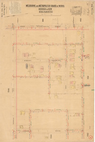
Plan, Melbourne & Metropolitan Board of Works : Borough of Kew : Detail Plan No.1565, 1905
... Named houses on the plan include ‘Tyrol’, ‘Glengorse’, ‘Theodore Villa’, ‘Arncliffe’, ‘Ballynira’ and ‘Hazeldene’. The plan also shows a Wesleyan Church in Sackville Street. In 1883, the Church’s Sunday School...Named houses on the plan include ‘Tyrol’, ‘Glengorse’, ‘Theodore Villa’, ‘Arncliffe’, ‘Ballynira’ and ‘Hazeldene’. The plan also shows a Wesleyan Church in Sackville Street. In 1883, the Church’s Sunday School ...The Melbourne and Metropolitan Board of Works (MMBW) plans were produced from the 1890s to the 1950s. They were crucial to the design and development of Melbourne's sewerage and drainage system. The plans, at a scale of 40 feet to 1 inch (1:480), provide a detailed historical record of Melbourne streetscapes and environmental features. Each plan covers one or two street blocks (roughly six streets), showing details of buildings, including garden layouts and ownership boundaries, and features such as laneways, drains, bridges, parks, municipal boundaries and other prominent landmarks as they existed at the time each plan was produced. (Source: State Library of Victoria). This plan forms part of a large group of MMBW plans and maps that was donated to the Society by the Mr Poulter, City Engineer of the City of Kew in 1989. Within this collection, thirty-five hand-coloured plans, backed with linen, are of statewide significance as they include annotations that provide details of construction materials used in buildings in the first decade of the 20th century as well as additional information about land ownership and usage. The copies in the Public Record Office Victoria and the State Library of Victoria are monochrome versions which do not denote building materials so that the maps in this collection are invaluable and unique tools for researchers and heritage consultants. A number of the plans are not held in the collection of the State Library of Victoria so they have the additional attribute of rarity.Original survey plan, issued by the MMBW to a contractor with responsibility for constructing sewers in the area identified on the plan within the Borough of Kew. The plan was at some stage hand-coloured, possibly by the contractor, but more likely by officers working in the Engineering Department of the Borough and later Town, then City of Kew. The hand-coloured sections of buildings on the plan were used to denote masonry or brick constructions (pink), weatherboard constructions (yellow), and public buildings (grey). MMBW Plan No.1565 is an example of a plan where a number of streets have been created since the area was surveyed, or in other cases renamed. The plan shows those streets that were bordered by Ross Street, Mount Street, Sackville Street and Burke Road. Since 1905, Mawson Street has been created and Mont Albert Road renamed as Dean Street. Named houses on the plan include ‘Tyrol’, ‘Glengorse’, ‘Theodore Villa’, ‘Arncliffe’, ‘Ballynira’ and ‘Hazeldene’. The plan also shows a Wesleyan Church in Sackville Street. In 1883, the Church’s Sunday School celebrated its silver anniversary.melbourne and metropolitan board of works, detail plans, mmbw 1565, cartography -
 Melton City Libraries
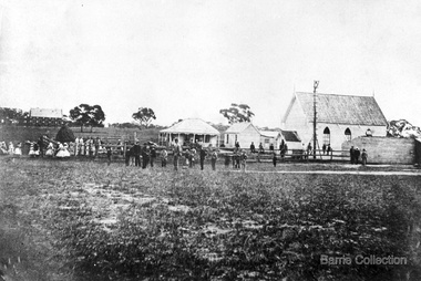
Photograph, Denominational Church and School, Unknown
... Presbyterian Church Melton Background: A Combined Denominational Church and School was established in Melton by Protestants from the Presbyterian, Episcopalian, Wesleyan and Baptists denominations. A wooden church was built on the flat area east of the Toolam Toolern Creek. A photo of this church shows the buildings with small houses...Presbyterian Church Melton Background: A Combined Denominational Church and School was established in Melton by Protestants from the Presbyterian, Episcopalian, Wesleyan and Baptists denominations. A wooden church was built on the flat area east of the Toolam Toolern Creek. A photo of this church shows the buildings with small houses ...Presbyterian Church Melton Background: A Combined Denominational Church and School was established in Melton by Protestants from the Presbyterian, Episcopalian, Wesleyan and Baptists denominations. A wooden church was built on the flat area east of the Toolam Toolern Creek. A photo of this church shows the buildings with small houses nearby. In the background the bluestone Presbyterian Church built in 1867 can be seen to the north on Yuille and Sherwin street. The flat area beside the road to Ballarat was subject to flooding and the site was eventually abandoned for a settlement. By the latter part of the 1860s the Church of England and Wesleyan bluestone churches were also being erected in the centre of the township of Melton. The commercial centre developed in High Street from Smith to Palmerston Street. Township of Melton Crown Grants Issued Under Common Law refers to the site of the Combined Denominational Church and School on the east side of Sherwin Street on the corner of Pyke Street. Section 4 Allotments 1 and 10 situated on the corner of Pyke, Bryan and Sherwin Street. The early map has the name of Thomas Cridge on this site. The area known Common (flat) remained open level ground with some cottages and buildings and a milk cooler in the 1930s, Granny Watts house “Lynch Cottage was moved in 1964. Sherwin Street was used until the 1960s with the open area being the used for playing golf. Alterations to the flat occurred when the golf course added to the height and removed the Sherwin Street access. The greens were developed and the height of ground altered the vista across Common. The first Presbyterian Minister in the district was the Reverend Alexander McNicol an advanced student and an experienced missionary from Glasgow, arriving in Melbourne in 1850. He was ordained on the 8th of June and was called to the Bacchus Marsh and Mount Macedon district. On the 1st of May 1851 he was called to Geelong and returned to Bacchus Marsh on February 1856 remaining until July 1859. Group of people in front of the church and school.churches, local identities, education -
![Book - Novel, Martin, Mrs A. H. (Mary Emma Martin), Roses from thorns : or the old manor house, [n.d.] [1887?]](/media/collectors/641920217f0478323d8a47a8/items/66790b85ea633ba0109bf7d9/item-media/67b6582c3824b0197b990617/item-fit-380x285.jpg?cb=6) Linton Mechanics Institute and Free Library Collection
Linton Mechanics Institute and Free Library CollectionBook - Novel, Martin, Mrs A. H. (Mary Emma Martin), Roses from thorns : or the old manor house, [n.d.] [1887?]
... Wesleyan/Methodist Sunday School library 1. Handwritten inscription on front endpaper: 'Linton Wesleyan / Sunday School /1889 / No. 165. ('165' has been crossed out and '182' subsituted, in blue pencil or crayon. 2. Inscription inside front cover, written in blue pencil or crayon: 'Linton Meth SS / Library / 182'. 152 p. : ill. Blue, red and gold cover, embossed in black - geometric design and leaves. List of other publications from Cassell & Co. at end of book. Roses from thorns : or the old manor house ...152 p. : ill. Blue, red and gold cover, embossed in black - geometric design and leaves. List of other publications from Cassell & Co. at end of book.fictionmary emma martin (mrs a. h. martin), children's fiction, wesleyan/methodist sunday school library -
 Sunshine and District Historical Society Incorporated
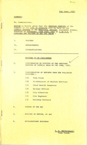
Administrative record - City of Sunshine - Commissioner Mr Alexander Alex George Gillon Collection 1976 - 1982 - Notice of ordinary council meeting 15th June 1977, City of Sunshine, 8th June 1977
... School...Kermeen Street...Sunshine West...D. J. Evans Hall...Churchill Avenue...Braybrook...Albanvale...Northumberland Road...Sunshine North...D. J. Evans Hall Committee...Wood Street...Deer Park...Munro Avenue...South Road...Wesleyan Church of Sunshine...Devonshire Road...Matthews Street...Furlong Road...Browne Avenue...Dickson Street...Mitchell Street...Maidstone...St. John's College...Consolidated Bearing Company...Yarmouth Ave...Belvedere Close...Maribyrnong...Forrest Street...Ardeer...Fraser Street...Sunshine Bus Lines...Ayton Street...House...School Kermeen Street Sunshine West D. J. Evans Hall Churchill Avenue Braybrook Albanvale Northumberland Road Sunshine North D. J. Evans Hall Committee Wood Street Deer Park Munro Avenue South Road Wesleyan Church of Sunshine Devonshire Road Matthews Street Furlong Road Browne Avenue Dickson Street Mitchell Street Maidstone St. John's College Consolidated Bearing Company Yarmouth Ave Belvedere Close Maribyrnong Forrest Street Ardeer Fraser Street Sunshine Bus Lines Ayton Street House ...Notice of Ordinary Council Meeting 15th June 1977 Report of the Town Clerk Glengala Park Primary School Agreement to use School Facilities Financil Reports D. J. Evans Hall Committee Applications From Persons For Rate Relief Who Are Not Automatically Entitled To Relief Approved By The Victorian Government Applications From Persons In Respect Of Possible Remission of rates From 1975/76 Conference Public Records Office Place Name Committee Naming of Albanvale Metropolitan Fire Brigade and the Country Fire Authority Revision of Voters list Surrender of lease 23C Northumberland Road Sunshine North Holiday Programme Report Report of the Chief Health Inspector Quarterly Return Food Sampling Report of City Engineer Proposed Amendment to Melbourne Metropolitan Planning Scheme Ordinance Service Bus Zone Proposed Amendment to Melbourne Metropolitan Planning Scheme Ordinance Advertising Signs In Residential Areas Flat Development Control Land Use Permit Application Addition of Two Flats Lot 51 Wood Street Land Use Permit Application Extension to Existing Workshop Lot 6 Munro Avenue Land Use Permit Application Coin Operated Launderette 113 South Road Land Use Permit Application Extension to Existing Wesleyan Church of Sunshine 139 - 143 Devonshire Road Cluster Subdivisions Land Use Permit Application Flats Lots 24 & 25 Matthews Street Land Use Permit Application Cluster Subdivision Furlong Road Land Use Permit Application Cluster Subdivision Furlong Road & Browne Avenue Tender for Tractor Drawn gang Mower Dickson Street private Street Scheme Nashua Photo Copying Machine Progress Claim and Variation to Quotation Easement Draingage lot 4 Mitchell Street Maidstone Land Use Permit Car Parking Alternative Proposal St. John's College Braybrook Creation of Easement Mitchell Street Consolidated Bearing Company, S.S.W. Freeholds & McPherson's Ltd Subdivision Creation of Easement Lots 18 & 19 Yarmouth Ave Subdivsion Proposed Stop Go Signals Hampshire Road / Wright Street and Market Road / Wright Street Contract Supply of Sanitary landfill compactor Tutt Bryant (Vic) Pty Ltd Report of the Building Surveyor Fence 14 Belvedere Close Undersize Allotment Lot 78 Forrest Street Ardeer Installation of Underground Tank Sunshine Bus Lines Fraser Street flammable Liquids Buildings Lots 2 & 3 Ayton Street Sunshine North Cleaning of Municipal Buildings Major Repairs to Council Buildings House of Sunshine, House of Happiness, Municipal Offices, Deer Park Hall, 10 Watt Street Child Care Program Indoor Swimming Pool Service Street city of sunshine, alexander "alex" george gillon, glengala park primary school, kermeen street, sunshine west, d. j. evans hall, churchill avenue, braybrook, albanvale, northumberland road, sunshine north, d. j. evans hall committee, wood street, deer park, munro avenue, south road, wesleyan church of sunshine, devonshire road, matthews street, furlong road, browne avenue, dickson street, mitchell street, maidstone, st. john's college, consolidated bearing company, yarmouth ave, belvedere close, maribyrnong, forrest street, ardeer, fraser street, sunshine bus lines, ayton street, house of sunshine, house of happiness, city of sunshine municipal offices, deer park hall, station road, alexandra avenue, watt street
