Showing 719 items matching " wests rd"
-
 Melbourne Tram Museum
Slide - Set of 2, Keith Caldwell, 15/03/1962 12:00:00 AM
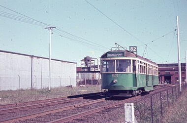
... ... Wests Rd...Melbourne Tram Museum 8 Wallen Road Hawthorn melbourne Trams tramways Route 82 VR Class Tramcars Footscray Moonee Ponds Reserved Track River St Wests Rd W5 class tram 53 tram 783 Set of two Agfa Colour slides, cardboard mounts, by Keith Caldwell dated 15 March 1962 of: .1 - VR class 53, route 82 to Moonee Ponds in the section that ran parallel to Wests Road Maribyrnong after turning from Williamson Road. .2 - W5 783, River St with White Horse Whiskey and a BOAC advertisements. ...Set of two Agfa Colour slides, cardboard mounts, by Keith Caldwell dated 15 March 1962 of: .1 - VR class 53, route 82 to Moonee Ponds in the section that ran parallel to Wests Road Maribyrnong after turning from Williamson Road. .2 - W5 783, River St with White Horse Whiskey and a BOAC advertisements.trams, tramways, route 82, vr class tramcars, footscray, moonee ponds, reserved track, river st, wests rd, w5 class, tram 53, tram 783 -
 Melbourne Tram Museum
Photograph - Set of 3 Colour Negatives, Phil A'Vard, 10/02/1962 12:00:00 AM
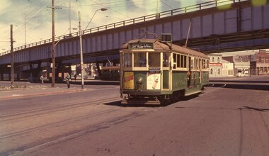
... ... Wests Rd...Melbourne Tram Museum 8 Wallen Road Hawthorn melbourne Trams tramways Footscray AETA Maribyrnong River Bridge Maribyrnong Rd Wests Rd Queensbridge St W4 class W3 class tram 670 Set of 3 photographs taken on the AETA tour Sat. 10/2/1962 - Closure of the Local Tram Routes at Footscray. .1 - W4 670 passing under the King St bridge in Queensbridge St, South Melbourne. ...Set of 3 photographs taken on the AETA tour Sat. 10/2/1962 - Closure of the Local Tram Routes at Footscray. .1 - W4 670 passing under the King St bridge in Queensbridge St, South Melbourne. Has an AETA tour Auxiliary board is showing Special. .2 - ditto, followed by W3 655 crossing the Maribyrnong Road Bridge. .3 - ditto - turning on the reserved track alongside Wests Road. Taken on Perutz film - see 3997 for the AETA Tour circular. and see 5998 for other photographs.trams, tramways, footscray, aeta, maribyrnong river bridge, maribyrnong rd, wests rd, queensbridge st, w4 class, w3 class, tram 670 -
 Ballarat RSL Sub-Branch Inc.
Razor Strop x 2 - Leather
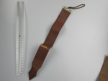
... Nil ID = "A-u-t-o Strop Safety Razor 2nd Quality Great West Rd. Middx. ENG"...Ballarat RSL Sub-Branch Inc. 330 Heinz Lane Invermay Park goldfields Personal items Ballarat RSL Ballarat Nil ID = "A-u-t-o Strop Safety Razor 2nd Quality Great West Rd. Middx. ENG" Razor Strop x 2 - Leather ...Nil ID = "A-u-t-o Strop Safety Razor 2nd Quality Great West Rd. Middx. ENG"personal items, ballarat rsl, ballarat -
 Melbourne Tram Museum
Slide - MMTB, and TMSV Tours and the Swanston St Olympic Torch - set of 7, Hugh Ballment, 1950s to 1960s
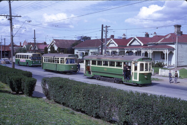
... HBM254 - MMTB Trams 676, 180, 10/09/1967, Maribyrnong Rd , Mk IV bus in background, on a TMSV tour HBM255 - MMTB Tram 106, 28/07/1968, Royal Park, Brown livery HBM256 - MMTB Trams 180 676, 10/09/1967, Wests Rd reservation, HBM257 - MMTB Trams 676, 180, 10/09/1967, East Coburg, HBM258 - MMTB Trams 676, 180, 10/09/1967, East Coburg, HBM259 - MMTB Trams 676, 180, 10/09/1967, Wests Rd reservation, has an open ballast crossover in the view. ...HBM254 - MMTB Trams 676, 180, 10/09/1967, Maribyrnong Rd , Mk IV bus in background, on a TMSV tour HBM255 - MMTB Tram 106, 28/07/1968, Royal Park, Brown livery HBM256 - MMTB Trams 180 676, 10/09/1967, Wests Rd reservation, HBM257 - MMTB Trams 676, 180, 10/09/1967, East Coburg, HBM258 - MMTB Trams 676, 180, 10/09/1967, East Coburg, HBM259 - MMTB Trams 676, 180, 10/09/1967, Wests Rd reservation, has an open ballast crossover in the view. ...Set of 7 photos by Hugh Ballment, of MMTB trams and TMSV Tours. HBM254 - MMTB Trams 676, 180, 10/09/1967, Maribyrnong Rd , Mk IV bus in background, on a TMSV tour HBM255 - MMTB Tram 106, 28/07/1968, Royal Park, Brown livery HBM256 - MMTB Trams 180 676, 10/09/1967, Wests Rd reservation, HBM257 - MMTB Trams 676, 180, 10/09/1967, East Coburg, HBM258 - MMTB Trams 676, 180, 10/09/1967, East Coburg, HBM259 - MMTB Trams 676, 180, 10/09/1967, Wests Rd reservation, has an open ballast crossover in the view. HBM260 - c1956, Swanston St, Olympics illumination Yields information about Melbourne tram operations, TMSV tours of the 1960s, and the olympicsKodachrome cardboard and plastic mounts, with notes - set of 7tramways, tmsv, tram 676, tram 180, maribyrnong road, royal park, wests road, east coburg, olympics, swanston st -
 Sunshine and District Historical Society Incorporated
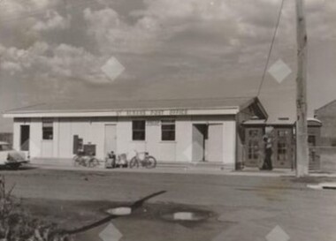
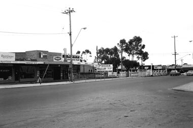
Photograph - 45 Main Rd West - St. Albans Post Office
... 45 Main Rd West - St. Albans Post Office...5659.01 - Main Rd West 45 - St. Albans Post Office Photo 01.jpg 5659.02 - Main Rd West 45 - St. ...Albans Post Office Photo 01.jpg 5659.02 - Main Rd West 45 - St. Albans Post Office Photo 02.jpg 5659.03 - Main Rd West 45 - St. ...The first St. Albans post office opened in 1888, just one year after the township was established in 1887. At this time, St Albans was little more than a railway station, a handful of houses, and Alfred Padley’s speculative subdivision. The location of the first post office changed over time, from the Railway Station and to general stores. The first record of a post office at this site appears in the 1960 edition of the Sands & Mcdougall Directory. This collection of photographs captures the basic building structure of the post office at this site and the post office staff and their customers.5659.01 - Main Rd West 45 - St. Albans Post Office Photo 01.jpg 5659.02 - Main Rd West 45 - St. Albans Post Office Photo 02.jpg 5659.03 - Main Rd West 45 - St. Albans Post Office Photo 03.jpg 5659.04 - Main Rd West 45 - St. Albans Post Office Photo 04.jpg 5659.05 - Main Rd West 45 - St. Albans Post Office Photo 05.jpg main road west, st. albans, st. albans post office -
 Bendigo Historical Society Inc.
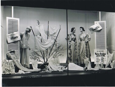
Photograph - HANRO COLLECTION: SHOP DISPLAY, Aug - Sept. 1956
... Jones 97 Hardgrave Rd. West End Brisbane...Jones 97 Hardgrave Rd. West End Brisbane Black and white photograph of a shop window display by Allan and Stark, Brisbane of Hanro underwear and slumberwear. ...Black and white photograph of a shop window display by Allan and Stark, Brisbane of Hanro underwear and slumberwear. The prices displayed are : Slips 37/6 , Scanties 16/11 , Briefs 12/11David R. Jones 97 Hardgrave Rd. West End Brisbaneorganization, business, hanro, hanro, clothing display, shop window display, smartex, slips, scanties, briefs -
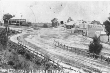
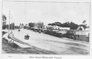
 Ringwood and District Historical Society
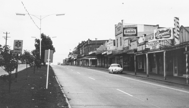
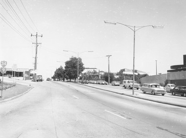
Photograph, Maroondah Highway, Ringwood. Looking west from Warrandyte Road - 1965
... Typed under photograph: "Main Street, looking west from Warrandyte Rd. 1965"....Ringwood and District Historical Society 125A Warrandyte Road Ringwood North melbourne Typed under photograph: "Main Street, looking west from Warrandyte Rd. 1965". Black and white photograph (2 copies) Maroondah Highway, Ringwood. ...Black and white photograph (2 copies)Typed under photograph: "Main Street, looking west from Warrandyte Rd. 1965". -
 Ringwood and District Historical Society
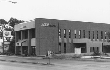
Photograph, ANZ Bank, Whitehorse Rd. West side. Ringwood, 1982
... ANZ Bank, Whitehorse Rd. West side. Ringwood, 1982...ANZ Bank, Whitehorse Rd. West side."...ANZ Bank, Whitehorse Rd. West side." ANZ Bank, Whitehorse Rd. West side. ...Catalogue card reads, "Ringwood, 1982. ANZ Bank, Whitehorse Rd. West side." -
 Ringwood and District Historical Society
Photograph, Maroondah Highway Central, Ringwood. View looking west from Warrandyte Road - 1974
... Written on rear of backing sheet: "Maroondah Highway, 1974 - West from Warrandyte Rd. ext."...Ringwood and District Historical Society 125A Warrandyte Road Ringwood North melbourne Written on rear of backing sheet: "Maroondah Highway, 1974 - West from Warrandyte Rd. ext." Black and white photograph Maroondah Highway Central, Ringwood. ...Black and white photographWritten on rear of backing sheet: "Maroondah Highway, 1974 - West from Warrandyte Rd. ext." -
 Ringwood and District Historical Society
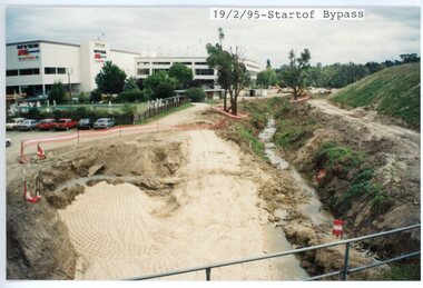
photograph, Eastlink Ringwood Bypass Construction-Start of Bypass 19/2/95
... Written on back of photo: "19/2/95-Start of Bypass Looking West from Warrandyte Rd"...Ringwood and District Historical Society 125A Warrandyte Road Ringwood North melbourne Written on back of photo: "19/2/95-Start of Bypass Looking West from Warrandyte Rd" Colour photograph Eastlink Ringwood Bypass Construction-Start of Bypass 19/2/95 photograph ...Colour photographWritten on back of photo: "19/2/95-Start of Bypass Looking West from Warrandyte Rd" -
 Sunshine and District Historical Society Incorporated
Photograph - Maribyrnong Photographs 2021 Part 3, John Alchin, 2021
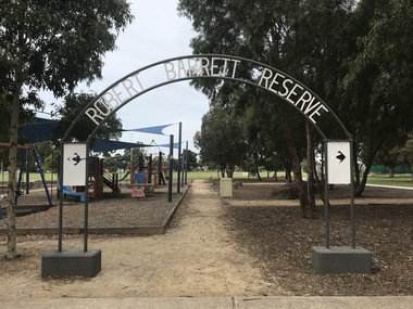
... Margaret's Catholic Church 2021 Photo 01.JPG 5600.09 - Van Ness Ave - Maribyrnong River Bike Path 2021 Photo 01.JPG 5600.10 - Wattle Ave Maribyrnong 2021 Photo 01.JPG 5600.11 - Wests Road - Gate House Place No 15 Maribyrnong 2021 Photo 01.JPG 5600.12 - Wests Road - Ordnance Factory Old Entrance 2021 Photo 01.JPG 5600.13 - Wests Road - Ordnance Factory Buildings West Rd 2021 Photo 01.JPG 5600.14 - Wests Road - Ordnance Factory Building 2021 Photo 02.JPG 5600.15 - Wests Road - Ordnance Factory Building 2021 Photo 04.JPG 5600.16 - Wests Road - Ordnance Factory Buildings West Rd 2021 Photo 02.JPG 5600.17 - Wests Road - Ordnance Factory Buildings West Rd 2021 Photo 03.JPG 5600.18 - Wests Road - Ordnance Factory Buildings West Rd 2021 Photo 04.JPG 5600.19 - Maribyrnong Explosive Factory Maribyrnong River 2021 Photo 01.JPG 5600.20 - Maribyrnong Explosive Factory Maribyrnong River 2021 Photo 02.JPG 5600.21 - Maribyrnong Explosive Factory Maribyrnong River 2021 Photo 03.JPG 5600.22 - Maribyrnong Explosive Factory Maribyrnong River 2021 Photo 04.JPG ...Margaret's Catholic Church 2021 Photo 01.JPG 5600.09 - Van Ness Ave - Maribyrnong River Bike Path 2021 Photo 01.JPG 5600.10 - Wattle Ave Maribyrnong 2021 Photo 01.JPG 5600.11 - Wests Road - Gate House Place No 15 Maribyrnong 2021 Photo 01.JPG 5600.12 - Wests Road - Ordnance Factory Old Entrance 2021 Photo 01.JPG 5600.13 - Wests Road - Ordnance Factory Buildings West Rd 2021 Photo 01.JPG 5600.14 - Wests Road - Ordnance Factory Building 2021 Photo 02.JPG 5600.15 - Wests Road - Ordnance Factory Building 2021 Photo 04.JPG 5600.16 - Wests Road - Ordnance Factory Buildings West Rd 2021 Photo 02.JPG 5600.17 - Wests Road - Ordnance Factory Buildings West Rd 2021 Photo 03.JPG 5600.18 - Wests Road - Ordnance Factory Buildings West Rd 2021 Photo 04.JPG 5600.19 - Maribyrnong Explosive Factory Maribyrnong River 2021 Photo 01.JPG 5600.20 - Maribyrnong Explosive Factory Maribyrnong River 2021 Photo 02.JPG 5600.21 - Maribyrnong Explosive Factory Maribyrnong River 2021 Photo 03.JPG 5600.22 - Maribyrnong Explosive Factory Maribyrnong River 2021 Photo 04.JPG This is a large collection of photographs which has been split over three identification numbers. ...Maribyrnong was originally part of the former Shire of Braybrook and later the City of Sunshine. However, in 1994, Victoria underwent council amalgamations, which resulted in Braybrook being incorporated into the City of Maribyrnong. The suburb of Maribyrnong continues to attract considerable attention from the residents of City of Brimbank, particularly its historical features, the old buildings and distinctive streetscapes that characterise the area.To capture the essence of Maribyrnong in 2021, a series of photographs were taken. These images document a range of buildings, street scenes, and other notable points of interest throughout the suburb, providing a visual record of its unique character.5600.01 - Robert Barrett Reserve 2021 Photo 01.JPG 5600.02 - Robert Barrett Reserve 2021 Photo 06.JPG 5600.03 - Robert Barrett Reserve 2021 Photo 07.JPG 5600.04 - Robert Barrett Reserve Rosamond Bowling Club 2021 Photo 09.JPG 5600.05 - Robert Barrett Reserve Rosamond Tennis Club 2021 Photo 10.JPG 5600.06 - Sandy 2021 Photo 01.JPG 5600.07 - Sandy 2021 Photo 02.JPG 5600.08 - The Esplanade Maribyrnong - St. Margaret's Catholic Church 2021 Photo 01.JPG 5600.09 - Van Ness Ave - Maribyrnong River Bike Path 2021 Photo 01.JPG 5600.10 - Wattle Ave Maribyrnong 2021 Photo 01.JPG 5600.11 - Wests Road - Gate House Place No 15 Maribyrnong 2021 Photo 01.JPG 5600.12 - Wests Road - Ordnance Factory Old Entrance 2021 Photo 01.JPG 5600.13 - Wests Road - Ordnance Factory Buildings West Rd 2021 Photo 01.JPG 5600.14 - Wests Road - Ordnance Factory Building 2021 Photo 02.JPG 5600.15 - Wests Road - Ordnance Factory Building 2021 Photo 04.JPG 5600.16 - Wests Road - Ordnance Factory Buildings West Rd 2021 Photo 02.JPG 5600.17 - Wests Road - Ordnance Factory Buildings West Rd 2021 Photo 03.JPG 5600.18 - Wests Road - Ordnance Factory Buildings West Rd 2021 Photo 04.JPG 5600.19 - Maribyrnong Explosive Factory Maribyrnong River 2021 Photo 01.JPG 5600.20 - Maribyrnong Explosive Factory Maribyrnong River 2021 Photo 02.JPG 5600.21 - Maribyrnong Explosive Factory Maribyrnong River 2021 Photo 03.JPG 5600.22 - Maribyrnong Explosive Factory Maribyrnong River 2021 Photo 04.JPG the esplanade, van ness avenue, wattle avenue, wests road, robert barrett reserve, rosamond bowling club, rosamond tennis club, sandy, st. margaret's catholic church, maribyrnong river bike path, maribyrnong explosive factory, maribyrnong ordnance factory -
 Ringwood and District Historical Society
Photograph, The Gospel Chapel in Warrandyte Road, Ringwood, 1973, 1973
... Written on back of photograph: "Gospel Hall, W'dyte Rd. west side, 40 yards south of Miles Ave. 11.7.73."...Ringwood and District Historical Society 125A Warrandyte Road Ringwood North melbourne Written on back of photograph: "Gospel Hall, W'dyte Rd. west side, 40 yards south of Miles Ave. 11.7.73." ...Black and white photographWritten on back of photograph: "Gospel Hall, W'dyte Rd. west side, 40 yards south of Miles Ave. 11.7.73." -
 Sunshine and District Historical Society Incorporated
Photograph - Main Road West - St. Albans Level Crossing Looking North - East 1969 Photograph
... 5665 - Main Rd West - St. Albans Level Crossing Looking North - East 1969 Photo 01.jpg...West St. Albans St. Albans Level Crossing St. Albans Railway Station 5665 - Main Rd West - St. ...For many years, the Bendigo train line was one of Victoria's busiest lines thus the boom gates were down for long periods. This created driver frustration, risk‑taking behaviour, pedestrians weaving through gates and cars queueing across the track. The crossing was classified one of Melbourne’s most dangerous crossings and in the 2000's there were three fatalities and over 60 near misses. The level crossing was finally removed in 2016 as part of the Victorian Government Level Crossing Removal Project (LXRP).This picture documents the shops that were once located on the west side of the railway crossing on the North side of Main Road West. These shops were removed many years before the level crossing removal as part of pervious railway works. 5665 - Main Rd West - St. Albans Level Crossing Looking North - East 1969 Photo 01.jpgmain road west, st. albans, st. albans level crossing, st. albans railway station -
 Andrew Ross Museum
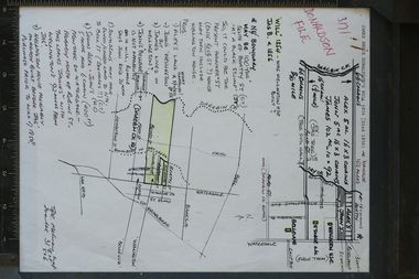
research note, A4, Donaldson property, Waterdale Rd with sketch maps, Early 1990's
... The Donalsdons of Kangaroo Ground owned property fronting Waterdale Rd West Heidelberg, used to camp cattle overnight on their way to/from saleyards in Melbourne....Andrew Ross Museum Main Road (Opposite General Store) Kangaroo Ground melbourne The Donalsdons of Kangaroo Ground owned property fronting Waterdale Rd West Heidelberg, used to camp cattle overnight on their way to/from saleyards in Melbourne. ...The Donalsdons of Kangaroo Ground owned property fronting Waterdale Rd West Heidelberg, used to camp cattle overnight on their way to/from saleyards in Melbourne.Prepared and used in the writing of "Kangaroo Ground: The Highland Taken (Mick Woiwod 1994)single sheet with 2 hand-drawn maps, annotated by Bruce Nixon. Notes refer to the Will of James Donaldson (D.1856) Could be a good photocopy with green pencil shading donaldson, nixon, bellevue, wellington house -
 Tarnagulla History Archive
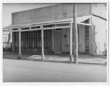
Photograph looking down Commercial Road, Tarnagulla, Looking down Commercial Road, Tarnagulla, c.1960s
... Shopfront located on west side of Commercial Rd between King and Poverty Streets. ...Tarnagulla History Archive Tarnagulla Public Hall 69-71 Commercial Rd Tarnagulla goldfields Murray Comrie Collection. Shopfront located on west side of Commercial Rd between King and Poverty Streets. ...Murray Comrie Collection. Shopfront located on west side of Commercial Rd between King and Poverty Streets. Original print.Monochrome photograph of a shopfront in Commercial Road, Tarnagulla. tarnagulla, buildings, businesses, commercial road -
 Sunshine and District Historical Society Incorporated
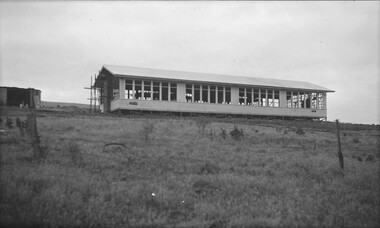
Photograph - Maribyrnong State School Under Construction Photographs
... In 1916 the school was relocated to the corner of Raleigh Street and Wests Rd. In 1942 the school moved to the Warrs Rd site. ...In 1916 the school was relocated to the corner of Raleigh Street and Wests Rd. In 1942 the school moved to the Warrs Rd site. ...Maribyrnong State School (also known as Maribyrnong Primary School) operated from the early 20th century until the late 20th century, serving the riverside industrial–residential community around Raleigh Road and the Maribyrnong River. The school was established in 1912. At first the school assembled in the Maribyrnong Methodist Church on the corner of Raleigh Street and Rosamond Rd. In 1916 the school was relocated to the corner of Raleigh Street and Wests Rd. In 1942 the school moved to the Warrs Rd site. During the post war and migration era’s (1950s–1970s), the school became increasingly multicultural due to the nearby Maribyrnong Migrant Hostel (opened 1949) with many European, Middle Eastern, and later Asian migrant students. Maribyrnong State School was one of the first inner west schools to run integration programs for newly arrived children, a pattern later continued by Maribyrnong High School. The school closed on the 31st December 1993. The school side was the sold to land developers who developed it into a small housing estate.This photograph captures the new school being built on the Warrs Road site in the early 1940's.maribyrnong state school, warrs road, maribyrnong -
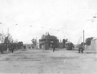
 Ringwood and District Historical Society
Photograph, Maroondah Highway Central, Ringwood. Whitehorse Road looking west. 1908
... Typed below one photograph: "Maroondah Highway Ringwood looking west. Warrandyte Rd coming in from right. 1908." Written on back of another photograph: "Fence divides two levels of road opp Warrandyte Rd looking west. ...Ringwood and District Historical Society 125A Warrandyte Road Ringwood North melbourne Typed below one photograph: "Maroondah Highway Ringwood looking west. Warrandyte Rd coming in from right. 1908." Written on back of another photograph: "Fence divides two levels of road opp Warrandyte Rd looking west. ...Photographs (3 copies- 2 black and white, 1 sepia postcard).Typed below one photograph: "Maroondah Highway Ringwood looking west. Warrandyte Rd coming in from right. 1908." Written on back of another photograph: "Fence divides two levels of road opp Warrandyte Rd looking west. Station Master's house on left." -
 Glenelg Shire Council Cultural Collection
Photograph - Photograph - oil tanks, n.d
... Black and white photograph showing shell oil tanks, west side of Wellington Rd. Photo taken from Fishermans breakwater area, Satcol on left, bridge over canal in front of tanks....Glenelg Shire Council Cultural Collection History House Cliff Street Portland great-ocean-road Port of Portland Authority Archives Port of Portland Archives oil tanks Back: 2398 Lines drawn in biro 5 3/4" 4 1/8" 8036 s/s in pencil Black and white photograph showing shell oil tanks, west side of Wellington Rd. Photo taken from Fishermans breakwater area, Satcol on left, bridge over canal in front of tanks. ...Port of Portland Authority ArchivesBack: 2398 Lines drawn in biro 5 3/4" 4 1/8" 8036 s/s in pencilport of portland archives, oil tanks -
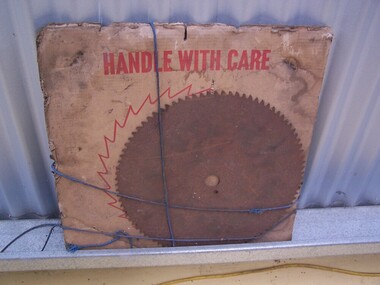 Puffing Billy Railway
Timber Mill - Packet of Round Saw Blades
... PTY 107 Northern Rd West Heidelberg Vic. Ph 45-4133 ...PTY 107 Northern Rd West Heidelberg Vic. Ph 45-4133 Timber Mill - Packet of Round Saw Blades made of steel Timber Mill - Packet of Round Saw Blades Melbourne Saw Manufacturing Co. ...Historic - Industrial - Timber Mill Saw BladesHistoric - Industrial - Timber Mill Saw BladesTimber Mill - Packet of Round Saw Blades made of steelHandle with Care A MSS Product 551 771 MI Melbourne Saw Manufacturing Co. PTY 107 Northern Rd West Heidelberg Vic. Ph 45-4133 puffing billy, timber mill saw blades, melbourne saw manufacturing co. -
 Melbourne Tram Museum
Photograph - Q.139 on Plenty Rd., c. 1930s, C. 1930s
... This photo depicts Q.139 (before all-night service modifications) on Plenty Rd., curving west towards Miller St (and Preston Depot). ...This photo depicts Q.139 (before all-night service modifications) on Plenty Rd., curving west towards Miller St (and Preston Depot). ...This photo depicts Q.139 (before all-night service modifications) on Plenty Rd., curving west towards Miller St (and Preston Depot). The destination sign “N[th?] Fitzroy is visible.Depicts (unmodified) Q class tram in the early 1930s.Black and white photographmmtb, electric trams, q class, plenty rd -
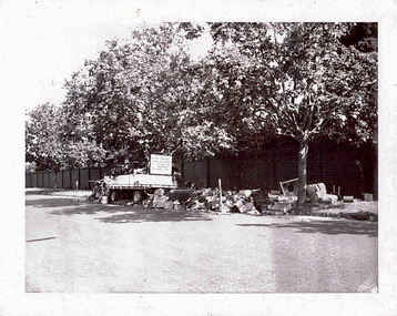 Kew Historical Society Inc
Photograph - Unburnable hard waste rubbish in the City of Kew, 1969
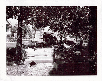
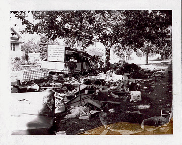
... Reverse: "17TH NOV 8.45 A.M. / PARKHILL RD WEST OF Adeney Ave." In envelope marked: "Kew City Council / 12 photos / 1969 1979 18980 1985 / Unburnable rubbish units 18/1/80"...One of a dated series of photographs of core local government services as practised by the City of Kew in the period 1969-1985. garbage hard rubbish garbage removal city of kew local government -- city of kew household waste hard waste hard waste units rubbish units rubbish trailers Reverse: "17TH NOV 8.45 A.M. / PARKHILL RD WEST OF Adeney Ave." In envelope marked: "Kew City Council / 12 photos / 1969 1979 18980 1985 / Unburnable rubbish units 18/1/80" Original black and white photographic positive of hard waste unburnable rubbish awaiting collection in Parkhill Rd in the City of Kew. ...One of twelve photographs donated by the City Engineer of the former City of Kew, mostly of hard rubbish clearance during the period 1969-1985.One of a dated series of photographs of core local government services as practised by the City of Kew in the period 1969-1985. Original black and white photographic positive of hard waste unburnable rubbish awaiting collection in Parkhill Rd in the City of Kew.Reverse: "17TH NOV 8.45 A.M. / PARKHILL RD WEST OF Adeney Ave." In envelope marked: "Kew City Council / 12 photos / 1969 1979 18980 1985 / Unburnable rubbish units 18/1/80"garbage, hard rubbish, garbage removal, city of kew, local government -- city of kew, household waste, hard waste, hard waste units, rubbish units, rubbish trailers -
 Kew Historical Society Inc
Photograph - Unburnable hard waste rubbish in the City of Kew, 1969
... Reverse: "17TH NOV 8.45 A.M. / PARKHILL RD WEST OF Adeney Ave." In envelope marked: "Kew City Council / 12 photos / 1969 1979 18980 1985 / Unburnable rubbish units 18/1/80"...One of a dated series of photographs of core local government services as practised by the City of Kew in the period 1969-1985. garbage hard rubbish garbage removal city of kew local government -- city of kew household waste hard waste hard waste units rubbish units rubbish trailers Reverse: "17TH NOV 8.45 A.M. / PARKHILL RD WEST OF Adeney Ave." In envelope marked: "Kew City Council / 12 photos / 1969 1979 18980 1985 / Unburnable rubbish units 18/1/80" Original black and white photographic positive of hard waste unburnable rubbish awaiting collection in Parkhill Rd in the City of Kew. ...One of twelve photographs donated by the City Engineer of the former City of Kew, mostly of hard rubbish clearance during the period 1969-1985.One of a dated series of photographs of core local government services as practised by the City of Kew in the period 1969-1985. Original black and white photographic positive of hard waste unburnable rubbish awaiting collection in Parkhill Rd in the City of Kew.Reverse: "17TH NOV 8.45 A.M. / PARKHILL RD WEST OF Adeney Ave." In envelope marked: "Kew City Council / 12 photos / 1969 1979 18980 1985 / Unburnable rubbish units 18/1/80"garbage, hard rubbish, garbage removal, city of kew, local government -- city of kew, household waste, hard waste, hard waste units, rubbish units, rubbish trailers -
 Ringwood and District Historical Society
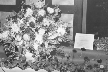
Photograph, Ringwood Horticultural Society- Ringwood Flower Show - 19 March 1959
... Goodwin had fifth shop in Main Street west of Warrandyte Rd. (Rly. other side of road.)...Goodwin had fifth shop in Main Street west of Warrandyte Rd. (Rly. other side of road.) Black and white photograph Ringwood Horticultural Society- Ringwood Flower Show - 19 March 1959. ...Black and white photographWritten on backing sheet, "1st Prize - Large floral window display at Goodwins Shoe Store. Mail 19 March 1959. Goodwin had fifth shop in Main Street west of Warrandyte Rd. (Rly. other side of road.) -
 Kew Historical Society Inc
Photograph - Hard rubbish in Parkhill Road
... Annotation in ink on reverse "17th Nov 1969 / 8.45a.m. / Parkhill Rd West of Adeney Ave". In envelope marked: "Kew City Council / 12 photos / 1969 1979 18980 1985 / Unburnable rubbish units 18/1/80"...One of a dated series of photographs of core local government services as practised by the City of Kew in the period 1969-1985. garbage hard rubbish garbage removal city of kew local government -- city of kew household waste hard waste Annotation in ink on reverse "17th Nov 1969 / 8.45a.m. / Parkhill Rd West of Adeney Ave". In envelope marked: "Kew City Council / 12 photos / 1969 1979 18980 1985 / Unburnable rubbish units 18/1/80" Original black and white photographic positive of unburnable hard waste awaiting collection in Parkhill Road, Kew in 1969. ...One of eight photographs donated by the City Engineer of the former City of Kew, mostly of hard rubbish clearance during the period 1969-1985.One of a dated series of photographs of core local government services as practised by the City of Kew in the period 1969-1985. Original black and white photographic positive of unburnable hard waste awaiting collection in Parkhill Road, Kew in 1969.Annotation in ink on reverse "17th Nov 1969 / 8.45a.m. / Parkhill Rd West of Adeney Ave". In envelope marked: "Kew City Council / 12 photos / 1969 1979 18980 1985 / Unburnable rubbish units 18/1/80"garbage, hard rubbish, garbage removal, city of kew, local government -- city of kew, household waste, hard waste -
 Bendigo Military Museum
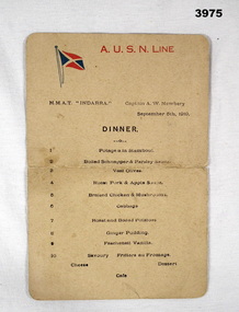
Pamphlet - SHIPS MENU, 5 Sept 1919
... Newberry Sept 5th 1919” On rear in pencil: “Ms Banks, 39 Pandora Rd, West Hampstead London, Maud Heightley, 33 Disraeli Road, Forest Gate E.7 Essex England”...Newberry Sept 5th 1919” On rear in pencil: “Ms Banks, 39 Pandora Rd, West Hampstead London, Maud Heightley, 33 Disraeli Road, Forest Gate E.7 Essex England” Menu card HMAT INDARRA detailing 10 dinner items. ...Items relate to "W D S BURNS" No 56 Provost Corpr AIF. Refer Cat No 2076.3P for his service details.Menu card HMAT INDARRA detailing 10 dinner items. At top AUSN Line in red & small blue / red flag representation underneath at L. Printed in black at top: “HMAT INDARRA Captain A.W. Newberry Sept 5th 1919” On rear in pencil: “Ms Banks, 39 Pandora Rd, West Hampstead London, Maud Heightley, 33 Disraeli Road, Forest Gate E.7 Essex England”hmat, menu, 56 provost aif, w d s burns -
 Ringwood and District Historical Society
Photograph, Maroondah Highway Central, Ringwood. Main Street, looking west from Warrandyte Rd, c1924
... Main Street, looking west from Warrandyte Rd, c1924....Typed below large photograph: "Main St looking west from Warrandyte Rd, c1924." Typed on back of one small photograph: "Coped from a circular for Mountain View Estate, J. ...Rd. Press, Rangeview & Mountview Avenues. Winnington just completed. 1924." Black and white photograph (2 copies- 1 large, 2 small) Maroondah Highway Central, Ringwood. Main Street, looking west ...Black and white photograph (2 copies- 1 large, 2 small) Typed below large photograph: "Main St looking west from Warrandyte Rd, c1924." Typed on back of one small photograph: "Coped from a circular for Mountain View Estate, J. Press, vendor, Second Av. Kew. In Mullum Rd, 90 yds from Oban Rd. Press, Rangeview & Mountview Avenues. Winnington just completed. 1924." -
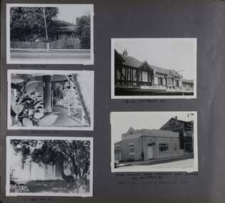 Glen Eira Historical Society
Album - Album page, Hawthorn Road, Circa 1972
... Handwritten: 17 HAWTHORN ROAD [under top left photo] / 17 HAWTHORN ROAD [under middle left photo] / 17 HAWTHORN ROAD [under bottom left photo] / 158-162 HAWTHORN ROAD [under top right photo] // STATE SAVINGS BANK CAULFIELD WEST BRANCH / 144 HAWTHORN RD / WEST SIDE - SOUTH OFF BALACLAVA ROAD [under bottom right photo] / 83 [bottom left] ...All photographs are black and white except where stated, with 386 photographs over 198 pages. 17 Hawthorn Road, North Caulfield is a contributory building to HO14 Caulfield North and environs, Caulfield North - Heritage Precinct in the City of Glen Eira. trevor hart caulfield hawthorn road verandahs houses shops banks state savings bank caulfield west caulfield north tudor style victorian style Handwritten: 17 HAWTHORN ROAD [under top left photo] / 17 HAWTHORN ROAD [under middle left photo] / 17 HAWTHORN ROAD [under bottom left photo] / 158-162 HAWTHORN ROAD [under top right photo] // STATE SAVINGS BANK CAULFIELD WEST BRANCH / 144 HAWTHORN RD / WEST SIDE - SOUTH OFF BALACLAVA ROAD [under bottom right photo] / 83 [bottom left] Page 83 of Photograph Album with five portrait photographs of 3 different properties on Hawthorn Road. ...This photograph is part of the Caulfield Historical Album 1972. This album was created in approximately 1972 as part of a project by the Caulfield Historical Society to assist in identifying buildings worthy of preservation. The album is related to a Survey the Caulfield Historical Society developed in collaboration with the National Trust of Australia (Victoria) and Caulfield City Council to identify historic buildings within the City of Caulfield that warranted the protection of a National Trust Classification. Principal photographer thought to be Trevor Hart, member of Caulfield Historical Society. Most photographs were taken between 1966-1972 with a small number of photographs being older and from unknown sources. All photographs are black and white except where stated, with 386 photographs over 198 pages. 17 Hawthorn Road, North Caulfield is a contributory building to HO14 Caulfield North and environs, Caulfield North - Heritage Precinct in the City of Glen Eira.Page 83 of Photograph Album with five portrait photographs of 3 different properties on Hawthorn Road. Addresses are handwritten underneath each property.Handwritten: 17 HAWTHORN ROAD [under top left photo] / 17 HAWTHORN ROAD [under middle left photo] / 17 HAWTHORN ROAD [under bottom left photo] / 158-162 HAWTHORN ROAD [under top right photo] // STATE SAVINGS BANK CAULFIELD WEST BRANCH / 144 HAWTHORN RD / WEST SIDE - SOUTH OFF BALACLAVA ROAD [under bottom right photo] / 83 [bottom left] trevor hart, caulfield, hawthorn road, verandahs, houses, shops, banks, state savings bank, caulfield west, caulfield north, tudor style, victorian style -
Melbourne Tram Museum
Newspaper, The Age, “Tram burns after collision with truck” “Quite heroes drag driver from flames”, 5/09/1970 12:00:00 AM
... Collision occurred about 2.35 pm as Preston-City tram travelling south in St George’s Rd and truck travelling west in Normandy Rd....Collision occurred about 2.35 pm as Preston-City tram travelling south in St George’s Rd and truck travelling west in Normandy Rd. “Tram burns after collision with truck” “Quite heroes drag driver from flames” Newspaper The Age Brian Carroll, Bill Armitage ...Newspaper clipping titled: “Tram burns after collision with truck” – The Age 5/9/70 “Quite heroes drag driver from flames” by Robert Parsonage Tram and semi-trailer crash in Thornbury, Route # 9A, driver Bill Armitage suffered a broken right leg and arm and severe burns to most of his body, in critical condition in Preston and Northcote Community Hospital. Semi-trailer driver, Brian Carroll, 25 received burns and is in serious condition in hospital. Conductor Ted Clark, about 35, not injured and helped only passenger, and elderly woman from the tram. Collision occurred about 2.35 pm as Preston-City tram travelling south in St George’s Rd and truck travelling west in Normandy Rd.trams, tramways, accidents, fire, route 9a, collision, st georges rd, thornbury -
 Sunshine and District Historical Society Incorporated
Photograph - St. Albans Photographs 2020, John Alchin, 2020
... Albans Uniting Church (Former Presbyterian Church) 14th Oct 2020.JPG 5555.07 - Stevens Farm Fence Main Rd West 30th Oct 2020.JPG 5555.08 - West Esplanade 37 - Former Shop.JPG ...Albans Uniting Church (Former Presbyterian Church) 14th Oct 2020.JPG 5555.07 - Stevens Farm Fence Main Rd West 30th Oct 2020.JPG 5555.08 - West Esplanade 37 - Former Shop.JPG Collection of digital photographs Photograph St. ...These photographs provide a visual record of assorted buildings, street views, and notable locations throughout St. Albans in 2020.This photograph collection documents St. Albans in 2020.5555.01 - Arthur Street 17 St. Albans 2nd April 2020 Photo 01.JPG 5555.02 - Arthur Street 17 St. Albans 2nd April 2020 Photo 02.JPG 5555.03 - Padley's House Winifred St 2nd April 2020 Photo 01.JPG 5555.04 - Padley's House Winifred St 2nd April 2020 Photo 02.JPG 5555.05 - St. Albans Arcade 323 Main Rd East St. Albans.JPG 5555.06 - St. Albans Uniting Church (Former Presbyterian Church) 14th Oct 2020.JPG 5555.07 - Stevens Farm Fence Main Rd West 30th Oct 2020.JPG 5555.08 - West Esplanade 37 - Former Shop.JPG st. albans uniting church, st. albans presbyterian church, stevens farm, st. albans arcade, arthur padley, chua hoang phap buddhist temple, arthur street, main road east, west esplanade, winifred street, main road west, st. albans -
 Melbourne Tram Museum
Album - Robert Thomson Slide Collection, AETA Convention 1971
... Number Brief Description RT123 1971 Convention - 9.4.71 - tram 610 - "Special" - Wattle park terminus RT124 Mt Alexander Road - 980 - "Special" RT125 St Kilda Jct - 7.4.71 - "St Kilda Beach" - route 16 RT126 North Balwyn Terminus - 9.4.71 - tram 840 - "Nth Balwyn" route 79 RT127 Preston - tram 980 - "City - Spencer St" - route 9A RT128 St Kilda Jct - "E Brighton Malv Burke Rd" - route 64 RT129 St Kilda Park St Terminus 12.4.71 - tram 394 - "Special" & tram 1017 - "West Preston - Northcote" - route 10 RT130 Carnegie 9.4.71 - tram 106 - "St Kilda Jun" - route 17 RT131 High St - tram 980 - "East Preston" - route 98 RT132 St Kilda Park St Terminus 12.4.71 - tram 894 - "West Preston" - route 10 RT133 St Kilda Park St Terminus 12.4.71 - tram 894 - "West Preston" - route 10 RT134 Wattle Park - 9.4.71 - tram 610 - "City" - route 70 RT135 Wellington Parade - 9.4.71 - tram 840 - "City - Flinders & Spencer St Cnr" - route 23 RT136 Melville Rd West Coburg 12.4.71 - tram 787 - route 55 ...Number Brief Description RT123 1971 Convention - 9.4.71 - tram 610 - "Special" - Wattle park terminus RT124 Mt Alexander Road - 980 - "Special" RT125 St Kilda Jct - 7.4.71 - "St Kilda Beach" - route 16 RT126 North Balwyn Terminus - 9.4.71 - tram 840 - "Nth Balwyn" route 79 RT127 Preston - tram 980 - "City - Spencer St" - route 9A RT128 St Kilda Jct - "E Brighton Malv Burke Rd" - route 64 RT129 St Kilda Park St Terminus 12.4.71 - tram 394 - "Special" & tram 1017 - "West Preston - Northcote" - route 10 RT130 Carnegie 9.4.71 - tram 106 - "St Kilda Jun" - route 17 RT131 High St - tram 980 - "East Preston" - route 98 RT132 St Kilda Park St Terminus 12.4.71 - tram 894 - "West Preston" - route 10 RT133 St Kilda Park St Terminus 12.4.71 - tram 894 - "West Preston" - route 10 RT134 Wattle Park - 9.4.71 - tram 610 - "City" - route 70 RT135 Wellington Parade - 9.4.71 - tram 840 - "City - Flinders & Spencer St Cnr" - route 23 RT136 Melville Rd West Coburg 12.4.71 - tram 787 - route 55 Demonstrates the work of Robert Thomson in photography, collection and/or production of slides Melbourne tramways trams Assembled album in a black presentation folder of 14 colour slides, collected or produced by Robert Thomson. ...Photo - see pdf file for further information. Number Brief Description RT123 1971 Convention - 9.4.71 - tram 610 - "Special" - Wattle park terminus RT124 Mt Alexander Road - 980 - "Special" RT125 St Kilda Jct - 7.4.71 - "St Kilda Beach" - route 16 RT126 North Balwyn Terminus - 9.4.71 - tram 840 - "Nth Balwyn" route 79 RT127 Preston - tram 980 - "City - Spencer St" - route 9A RT128 St Kilda Jct - "E Brighton Malv Burke Rd" - route 64 RT129 St Kilda Park St Terminus 12.4.71 - tram 394 - "Special" & tram 1017 - "West Preston - Northcote" - route 10 RT130 Carnegie 9.4.71 - tram 106 - "St Kilda Jun" - route 17 RT131 High St - tram 980 - "East Preston" - route 98 RT132 St Kilda Park St Terminus 12.4.71 - tram 894 - "West Preston" - route 10 RT133 St Kilda Park St Terminus 12.4.71 - tram 894 - "West Preston" - route 10 RT134 Wattle Park - 9.4.71 - tram 610 - "City" - route 70 RT135 Wellington Parade - 9.4.71 - tram 840 - "City - Flinders & Spencer St Cnr" - route 23 RT136 Melville Rd West Coburg 12.4.71 - tram 787 - route 55 Demonstrates the work of Robert Thomson in photography, collection and/or production of slidesAssembled album in a black presentation folder of 14 colour slides, collected or produced by Robert Thomson. All photographs have been scanned and placed on the Museum's G drive. A list of all photographs with details has been compiled. melbourne, tramways, trams