Showing 189 items matching "additional land"
-
 Save the Dandenongs League Inc.
Archive (item), Save the Dandenongs League Incorporated, Save the Dand. League - Shire Yarra Ranges Amendment L87 + 109 re Crown land additional from Melb. Water - Olinda Creek
... League - Shire Yarra Ranges Amendment L87 + 109 re Crown land additional from Melb. Water - Olinda Creek...League - Shire Yarra Ranges Amendment L87 + 109 re Crown land additional from Melb. Water - Olinda Creek Archive Save the Dandenongs League Incorporated ... -
 University of Melbourne, Burnley Campus Archives
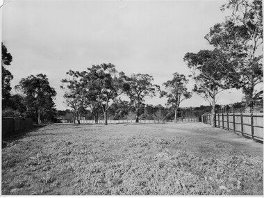
Photograph - Black and white print, Area Added in Late 1940's, Late 1940's
... ...additional land...First use of this area was for an apiary, and it is now a native garden." eucalypts green grows our garden a.p. winzenried apiary native garden additional land On reverse, "Late 1940's." Black and white photograph. ...Appears as an illustration in, "Green Grows Our Garden," A.P. Winzenried p 87. The caption reads, "Area added to the garden in the late 1940's. First use of this area was for an apiary, and it is now a native garden."Black and white photograph. Fenced and grassed area with Eucalypts around the perimeter.On reverse, "Late 1940's."eucalypts, green grows our garden, a.p. winzenried, apiary, native garden, additional land -
University of Melbourne, Burnley Campus Archives
Newspaper - Newspaper Cutting, The Age, Horticultural Society, 1865
... ...additional grant of land...University of Melbourne, Burnley Campus Archives 500 Yarra Boulevard Richmond melbourne floods gardens annual general meeting horticultural society of victoria flood damage ornamental garden used for fruit trees additional grant of land Copy of article in "The Age" 20 July, 1865 p7. ...Copy of article in "The Age" 20 July, 1865 p7. Description of Annual General Meeting. Grounds unfit for purpose after 1863 flood. Young stock being planted in part of Ornamental Garden. Government allowing Society to select more suitable ground near to present garden.floods, gardens, annual general meeting, horticultural society of victoria, flood damage, ornamental garden used for fruit trees, additional grant of land -
 Bendigo Historical Society Inc.
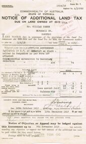
Document - GLENYS MCKITTERICK COLLECTION: WILLIAM BEEBE DOCUMENTS, 1st June 1915
... Notice of Additional Land Tax due on land owned at 30/6/1914, Mr William Beebe Mitchell St Bendigo. ...History House 11 Mackenzie Street Bendigo goldfields PERSON Bendigo William Beebe Beebe land Tax Notice of Additional Land Tax due on land owned at 30/6/1914, Mr William Beebe Mitchell St Bendigo. ...Notice of Additional Land Tax due on land owned at 30/6/1914, Mr William Beebe Mitchell St Bendigo. A/10062. Notification 1/6/15. Previous Assessment Inclusion of U.V. of interest as share - holder in Companies as per Form 107.Due date 10th October 1917, signed by Deputy Commissioners Ewing and Eastford.person, bendigo, william beebe, beebe, land tax -
 University of Melbourne, Burnley Campus Archives
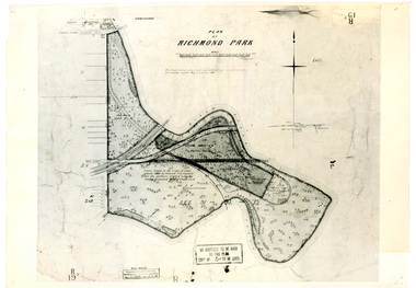
Plan, Plan of Richmond Park, 1886-1948
... Plan of Richmond Park with Horticultural Society Gardens marked in. Includes additional land which became the Field Station. ...Plan of Richmond Park with Horticultural Society Gardens marked in. Includes additional land which became the Field Station. ...(1) Black and white photographed copy of an original coloured plan. Plan of Richmond Park with Horticultural Society Gardens marked in. Includes additional land which became the Field Station. Original plan dated 31 August 1872, note of Crown Grant to the Board of Land & Works and Richmond City Council 1886; showing land, "Permanently Preserved for the Gardens". Stamp, "Department of Lands and Survey Photographed at the Central Plan Office 1/1 Plate 7.12.48" (2) Also 2 photocopies, 1 reduced - possibly used in a publication1 photocopy has "Figure 1. Plan of Burnley Gardens circa 1863 [sic]gardens, richmond, horticultural society of victoria, richmond park, a.l. martin -
 Ringwood and District Historical Society
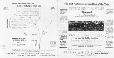
Document, Land Sale brochure, Pratt's Junction Estate, Ringwood. 1923
... (See also VC5175 for identical image and additional information of Land Sale)...(See also VC5175 for identical image and additional information of Land Sale) Black and white copy of double-sided printed brochure advertising 86 residential lots for sale by Public Auction on Saturday, November 24th, 1923. ...Black and white copy of double-sided printed brochure advertising 86 residential lots for sale by Public Auction on Saturday, November 24th, 1923.Brochure includes town photographs, map of subdivision and summary of local features and services. (See also VC5175 for identical image and additional information of Land Sale) -
Ringwood and District Historical Society
Document - Land Title, John Quinlan et al, Land title (Ringwood) and correspondence between George Pratt of Nunawading and the Commissioner of Crown Lands 1869-1877, 1869
... Land title and correspondence between George Pratt and the Commissioner of Crown Lands and Survey dated 19th(?) August 1869. Numbered 16678 (1M) plus 20 pages marked 42M-61M +Additional Keywords: Commissioner of Land and Survey / Longmare, Mr. / Quinlan, John...Ringwood and District Historical Society 125A Warrandyte Road Ringwood North melbourne Land title and correspondence between George Pratt and the Commissioner of Crown Lands and Survey dated 19th(?) August 1869. Numbered 16678 (1M) plus 20 pages marked 42M-61M +Additional Keywords: Commissioner of Land and Survey / Longmare, Mr. / Quinlan, John Land title (Ringwood) and correspondence between George Pratt of Nunawading and the Commissioner of Crown Lands 1869-1877 Document Land Title John Quinlan Mr Longmare ...Land title and correspondence between George Pratt and the Commissioner of Crown Lands and Survey dated 19th(?) August 1869. Numbered 16678 (1M) plus 20 pages marked 42M-61M +Additional Keywords: Commissioner of Land and Survey / Longmare, Mr. / Quinlan, John -
 Bendigo Historical Society Inc.
Document - CENTRAL NELL GWYNNE MINE: RESTORATION OF POPPET LEGS
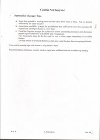
... Handwritten paper regarding restoration of poppet legs, request for additional area of land to cover area occupied by engine beds and engine house and painting of the legs with primer. ...History House 11 Mackenzie Street Bendigo goldfields MINE Gold central nell gwynne mine Central Nell Gwynne Mine Restoration of Poppet Legs Mr Jackman Mines Dep't Carlisle United Central Nell Gwynne Mine Fortuna Hustlers Handwritten paper regarding restoration of poppet legs, request for additional area of land to cover area occupied by engine beds and engine house and painting of the legs with primer. ...Handwritten paper regarding restoration of poppet legs, request for additional area of land to cover area occupied by engine beds and engine house and painting of the legs with primer. Small piece of paper mentions South Nell Mine commenced operations 7//2/41 and Mine Reports Mr. Jackman from the Mines Dep't has had typed, Carlisle United, Central Nell Gwynne Mine and Fortuna Hustlers. Images 3509.10a,10b,10c,10d,10emine, gold, central nell gwynne mine, central nell gwynne mine, restoration of poppet legs, mr jackman, mines dep't, carlisle united, central nell gwynne mine, fortuna hustlers -
Federation University Historical Collection
Photograph - Black and White, Former Ballarat Library, c1960
... Lease was granted and the old mining boardroom was initially used. Land for additional building to house a Museum and Art Gallery sought and agreement reached in 1882-3. ...Lease was granted and the old mining boardroom was initially used. Land for additional building to house a Museum and Art Gallery sought and agreement reached in 1882-3. ...First known development on this site was the establishment of the Government Camp from the early 1850s. It was established to accommodate officials, troopers and police who were needed to administer the goldfields. Some permanent buildings were constructed. Lack of materials and bad weather prolonged the building of more permanent buildings and most men were still living in tents. Area was known as Camp Reserve. In 1864 a subdivision map shows the reserve be used for Public Buildings. Library applied for land on corner of Sturt and Camp Streets in 1878. 1880s plans show section of the reserve be used for a Free Library and Reading Room. Lease was granted and the old mining boardroom was initially used. Land for additional building to house a Museum and Art Gallery sought and agreement reached in 1882-3. Compensation paid to owners and library granted the land. Plans for a new library building with tower and lantern roof abandoned due to lack of funds. It wasn't until 1895 that a solution to funding was found and the library was able to begin constructing the complex of buildings on the Free Library Reserve. A number of changes have occurred since 1910s - the Classical Revival facade replaced with an angled facade in a stripped Classical style with Art Deco features and high parapet. Building is now part of Federation UniversityPhotograph of former library. Shows a two-storey rendered brick building in a Classical style. Some Art Deco features. Central pair of double windows with single window either side. High parapet above.government camp, goldfields, camp reserve, free library, reading room, sturt street, camp street, museum, art gallery, troopers, police, barracks, camp street -
 Eltham District Historical Society Inc
Book, Mick Woiwod, Barak vs the Black Hats of Melbourne: The Untold Story of How the Black Hats Destroyed Coranderrk, July 2017
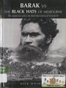
... land grazed by a dairy herd, plus further paddocks devoted to wheat, oats and hops. Enter the 'Black Hats of Melbourne' a wealthy lobby-group committed to the introduction and release into the Victorian bush of such alien creatures as deer, hare, salmon and grouse. In 1874, intent upon additional...land grazed by a dairy herd, plus further paddocks devoted to wheat, oats and hops. Enter the 'Black Hats of Melbourne' a wealthy lobby-group committed to the introduction and release into the Victorian bush of such alien creatures as deer, hare, salmon and grouse. In 1874, intent upon additional ...European settlement had removed the Wurundjeri from their hunting grounds in the Yarra Valley. In 1863, after twenty-eight years of dispossession and the death of most of the Colony's 'first people', a repentant government had returned 4,860 acres of land to its Wurundjeri people - they named it Coranderrk. Upon it, the survivors had enthusiastically built a village of twenty-three slab cottages with around it some 500 acres of cleared land grazed by a dairy herd, plus further paddocks devoted to wheat, oats and hops. Enter the 'Black Hats of Melbourne' a wealthy lobby-group committed to the introduction and release into the Victorian bush of such alien creatures as deer, hare, salmon and grouse. In 1874, intent upon additional introductions onto their land, these Black Hats had organised the dismissal of Coranderrk's high-achieving manager. Then, when later informed that senior Elder William Barak, had shot five of their released deer they had taken control of the Board for the Protection of Aborigines (BPA) and set about the expulsion of its residents to a remote location on the Murray. Standing four-square in their way had been William Barak who, by leading a series of deputations into Melbourne, had blocked every move by the Black Hats to close Coranderrk. Undeterred, these determined intruders had starved Coranderrk of funding and appointed a succession of scurrilous managers with instructions to run the station into the ground. The result was its closure in 1924.coranderrk, wurundjeri, william barak, black hats of melbourne, board for the protection of aborigines (bpa) -
 Sunshine and District Historical Society Incorporated
Archive - The Hunt Club Deer Park
... Booklet Hunt Club Community Arts Centre Biennial Report Thursday 26 October 1995|Typed Notes about History of the Deer Park Hunt Club|Spreadsheet for the Hunt Club Caretaker's residence detailing components and condition|Museum Catalogue Worksheet|Sunshine and District Historical Society Newletter No 7 August 1980|Newspaper Article Brimbank Messenger 6 July 1999 Creation Theories Blue Spoons Big Sky opens up for Blue Trio|Newspaper Article Independent 6 July 1999 Artistic pair launches Blue Trio|Newspaper Article Brimbank Leader 5 April 2005 Hunting gives way to the arts|Newspaper Article Brimbank Messenger 21 July 1999 What does it all mean|Newspaper Article Sunshine Advocate 11 March 1981 A gloomy future for a Sunshine historic building|Newspaper Article History in the offing|Newspaper Article Sunshine Advocate 19 June 2007 Mural of mystery|Invitation for Rainbow Workshop 22 November 1985|Booklet Hunt Club Community Centre Biennial Report Thursday 24 October 1991|Booklet Chairpersons report 1991|Invitation You're It 9 September 1993|Invitation Free Family Fun Day 30 January 1994|Typed Hunt Club Community Newsletter No 1 1 July 1994|Booklet Hunt Club Community Arts Centre Program Term 2 1994|Booklet Hunt Club Community Arts Centre Program Term 4 1994|Conservation Analysis and Conservation plan for Former Hunt Club Hotel Deer Park Nigel Lewis and Associates 1985|City Engineer Director of Technical and Environmental Services Department 20 August 1985 Hunt Club Buildings|Applications for Use of the Hunt Club Community Centre|Fees & conditions of use for rooms|Deer Park Hunt Club Hotel Building in Ballarat Road owned by ICI Previous Hotels on the same site|Hunt Club Hotel Ballarat Road Deer Park Reservation of Items of Historical Interest|Hand written note Hunt Club Hotel|Typed Letter to Mr TW Deutschmann Town Clerk dated 18 November 1982|Typed letter to Mr Paul Anstey Municipal Offices|Typed letter to Mr N Humphries Sunshine and District Historical Society dated 18 July 1984|Report on Hunt Club building Olwen Ford 22 February 1984|Letters Lions Club of Deer Park 11 March 1983|Letter to The Town Clerk City of Sunshine 29 April 1983 concerns about vandalism at Hunt Club|Letter from Municipal Offices 12 May 1983 a report prepared and will be presented to Council|Report Town Clerks Department 3 July Hunt Club proposed use|Letter to Town Clerk 1st August 1983|Letter to ARC Engineering asking for window screens 3 August 1983|Letter to The Town Clerk 3 August 1983 Security|Letter from Municipal Offices 4 August 1983 Use of Council Committee Room|Annual Report of the Interim Committee of Management Hunt Club Hotel November 1983|Letter to Municipal Offices 1 August 1983 wine bar and restaurant concerns at Hunt Club Hotel|Letter from St John Ambulance Brigade inspection of Hunt Club as suitable site for use of the Brigade 29 May 1983|Letter 19 March 1987 Hunt Club Committee of Management|Letter to Town Clerk from Price Brent Solicitors 7 June 1988 Hunt Club Committee of Management|Deed of Delegation agreement|Guidelines for the use of the Hunt Club|City of Sunshine 19 June 1989 Minutes of last meeting of the Hunt Club Committee of Management|City of Sunshine Specification of Duties and Conditions of Employment Caretaker Hunt Club Community Centre|Aims of the Hunt Club Community Centre|Amendments Additions and comments to the Hunt Club Community Centre Advisory Committe Constitution as submitted by Mr F Ford Mr D Webster Mr B Parsons and Mr J Willaton|Draft Resolution Deed of Delegation|Conditions and Responsibilites of Use|Sunshine City Library invite to frist Sunshine Community Arts Advisory Committee 17th July 1986|Constitution of the Hunt Club Community Centre Committee|Sunshine and District Historical Society Report for Hunt Club Committee 25 June 1997|Draft Licence agreement between Sunshine and District Historical Society and Brimbank City Council 31 July 1998|Aerial photographs|Hand written notes about Hunt Club|Reports and Recommendations of Committees of Council Administration and Finance Committee Minutes 4 June 1985|Memorandum to Manager Environmental services from Town Clerk 14 October 1985 Purchase of additional land...The Hunt Club Ballarar Road Deer Park Booklet Hunt Club Community Arts Centre Biennial Report Thursday 26 October 1995|Typed Notes about History of the Deer Park Hunt Club|Spreadsheet for the Hunt Club Caretaker's residence detailing components and condition|Museum Catalogue Worksheet|Sunshine and District Historical Society Newletter No 7 August 1980|Newspaper Article Brimbank Messenger 6 July 1999 Creation Theories Blue Spoons Big Sky opens up for Blue Trio|Newspaper Article Independent 6 July 1999 Artistic pair launches Blue Trio|Newspaper Article Brimbank Leader 5 April 2005 Hunting gives way to the arts|Newspaper Article Brimbank Messenger 21 July 1999 What does it all mean|Newspaper Article Sunshine Advocate 11 March 1981 A gloomy future for a Sunshine historic building|Newspaper Article History in the offing|Newspaper Article Sunshine Advocate 19 June 2007 Mural of mystery|Invitation for Rainbow Workshop 22 November 1985|Booklet Hunt Club Community Centre Biennial Report Thursday 24 October 1991|Booklet Chairpersons report 1991|Invitation You're It 9 September 1993|Invitation Free Family Fun Day 30 January 1994|Typed Hunt Club Community Newsletter No 1 1 July 1994|Booklet Hunt Club Community Arts Centre Program Term 2 1994|Booklet Hunt Club Community Arts Centre Program Term 4 1994|Conservation Analysis and Conservation plan for Former Hunt Club Hotel Deer Park Nigel Lewis and Associates 1985|City Engineer Director of Technical and Environmental Services Department 20 August 1985 Hunt Club Buildings|Applications for Use of the Hunt Club Community Centre|Fees & conditions of use for rooms|Deer Park Hunt Club Hotel Building in Ballarat Road owned by ICI Previous Hotels on the same site|Hunt Club Hotel Ballarat Road Deer Park Reservation of Items of Historical Interest|Hand written note Hunt Club Hotel|Typed Letter to Mr TW Deutschmann Town Clerk dated 18 November 1982|Typed letter to Mr Paul Anstey Municipal Offices|Typed letter to Mr N Humphries Sunshine and District Historical Society dated 18 July 1984|Report on Hunt Club building Olwen Ford 22 February 1984|Letters Lions Club of Deer Park 11 March 1983|Letter to The Town Clerk City of Sunshine 29 April 1983 concerns about vandalism at Hunt Club|Letter from Municipal Offices 12 May 1983 a report prepared and will be presented to Council|Report Town Clerks Department 3 July Hunt Club proposed use|Letter to Town Clerk 1st August 1983|Letter to ARC Engineering asking for window screens 3 August 1983|Letter to The Town Clerk 3 August 1983 Security|Letter from Municipal Offices 4 August 1983 Use of Council Committee Room|Annual Report of the Interim Committee of Management Hunt Club Hotel November 1983|Letter to Municipal Offices 1 August 1983 wine bar and restaurant concerns at Hunt Club Hotel|Letter from St John Ambulance Brigade inspection of Hunt Club as suitable site for use of the Brigade 29 May 1983|Letter 19 March 1987 Hunt Club Committee of Management|Letter to Town Clerk from Price Brent Solicitors 7 June 1988 Hunt Club Committee of Management|Deed of Delegation agreement|Guidelines for the use of the Hunt Club|City of Sunshine 19 June 1989 Minutes of last meeting of the Hunt Club Committee of Management|City of Sunshine Specification of Duties and Conditions of Employment Caretaker Hunt Club Community Centre|Aims of the Hunt Club Community Centre|Amendments Additions and comments to the Hunt Club Community Centre Advisory Committe Constitution as submitted by Mr F Ford Mr D Webster Mr B Parsons and Mr J Willaton|Draft Resolution Deed of Delegation|Conditions and Responsibilites of Use|Sunshine City Library invite to frist Sunshine Community Arts Advisory Committee 17th July 1986|Constitution of the Hunt Club Community Centre Committee|Sunshine and District Historical Society Report for Hunt Club Committee 25 June 1997|Draft Licence agreement between Sunshine and District Historical Society and Brimbank City Council 31 July 1998|Aerial photographs|Hand written notes about Hunt Club|Reports and Recommendations of Committees of Council Administration and Finance Committee Minutes 4 June 1985|Memorandum to Manager Environmental services from Town Clerk 14 October 1985 Purchase of additional land Collection of documents relating to The Hunt Club Deer Park History and Buildings Archive The Hunt Club Deer Park ...Booklet Hunt Club Community Arts Centre Biennial Report Thursday 26 October 1995|Typed Notes about History of the Deer Park Hunt Club|Spreadsheet for the Hunt Club Caretaker's residence detailing components and condition|Museum Catalogue Worksheet|Sunshine and District Historical Society Newletter No 7 August 1980|Newspaper Article Brimbank Messenger 6 July 1999 Creation Theories Blue Spoons Big Sky opens up for Blue Trio|Newspaper Article Independent 6 July 1999 Artistic pair launches Blue Trio|Newspaper Article Brimbank Leader 5 April 2005 Hunting gives way to the arts|Newspaper Article Brimbank Messenger 21 July 1999 What does it all mean|Newspaper Article Sunshine Advocate 11 March 1981 A gloomy future for a Sunshine historic building|Newspaper Article History in the offing|Newspaper Article Sunshine Advocate 19 June 2007 Mural of mystery|Invitation for Rainbow Workshop 22 November 1985|Booklet Hunt Club Community Centre Biennial Report Thursday 24 October 1991|Booklet Chairpersons report 1991|Invitation You're It 9 September 1993|Invitation Free Family Fun Day 30 January 1994|Typed Hunt Club Community Newsletter No 1 1 July 1994|Booklet Hunt Club Community Arts Centre Program Term 2 1994|Booklet Hunt Club Community Arts Centre Program Term 4 1994|Conservation Analysis and Conservation plan for Former Hunt Club Hotel Deer Park Nigel Lewis and Associates 1985|City Engineer Director of Technical and Environmental Services Department 20 August 1985 Hunt Club Buildings|Applications for Use of the Hunt Club Community Centre|Fees & conditions of use for rooms|Deer Park Hunt Club Hotel Building in Ballarat Road owned by ICI Previous Hotels on the same site|Hunt Club Hotel Ballarat Road Deer Park Reservation of Items of Historical Interest|Hand written note Hunt Club Hotel|Typed Letter to Mr TW Deutschmann Town Clerk dated 18 November 1982|Typed letter to Mr Paul Anstey Municipal Offices|Typed letter to Mr N Humphries Sunshine and District Historical Society dated 18 July 1984|Report on Hunt Club building Olwen Ford 22 February 1984|Letters Lions Club of Deer Park 11 March 1983|Letter to The Town Clerk City of Sunshine 29 April 1983 concerns about vandalism at Hunt Club|Letter from Municipal Offices 12 May 1983 a report prepared and will be presented to Council|Report Town Clerks Department 3 July Hunt Club proposed use|Letter to Town Clerk 1st August 1983|Letter to ARC Engineering asking for window screens 3 August 1983|Letter to The Town Clerk 3 August 1983 Security|Letter from Municipal Offices 4 August 1983 Use of Council Committee Room|Annual Report of the Interim Committee of Management Hunt Club Hotel November 1983|Letter to Municipal Offices 1 August 1983 wine bar and restaurant concerns at Hunt Club Hotel|Letter from St John Ambulance Brigade inspection of Hunt Club as suitable site for use of the Brigade 29 May 1983|Letter 19 March 1987 Hunt Club Committee of Management|Letter to Town Clerk from Price Brent Solicitors 7 June 1988 Hunt Club Committee of Management|Deed of Delegation agreement|Guidelines for the use of the Hunt Club|City of Sunshine 19 June 1989 Minutes of last meeting of the Hunt Club Committee of Management|City of Sunshine Specification of Duties and Conditions of Employment Caretaker Hunt Club Community Centre|Aims of the Hunt Club Community Centre|Amendments Additions and comments to the Hunt Club Community Centre Advisory Committe Constitution as submitted by Mr F Ford Mr D Webster Mr B Parsons and Mr J Willaton|Draft Resolution Deed of Delegation|Conditions and Responsibilites of Use|Sunshine City Library invite to frist Sunshine Community Arts Advisory Committee 17th July 1986|Constitution of the Hunt Club Community Centre Committee|Sunshine and District Historical Society Report for Hunt Club Committee 25 June 1997|Draft Licence agreement between Sunshine and District Historical Society and Brimbank City Council 31 July 1998|Aerial photographs|Hand written notes about Hunt Club|Reports and Recommendations of Committees of Council Administration and Finance Committee Minutes 4 June 1985|Memorandum to Manager Environmental services from Town Clerk 14 October 1985 Purchase of additional landthe hunt club, ballarar road, deer park -
 Eltham District Historical Society Inc
Document - Archive Box, 1570 Main Road, Research (Research Primary School)
... Cole 18.6.91 • Photocopy: Petition for a school at Research, 13/11/1888; Public Record Office Victoria School Building File – School 2959 CUPRS 795/1717 • Photocopy: Negotiation to buy school site – part of Allotment 2, owned by the West family (copy attached to letter) 15/1/1890; Public Record Office Victoria School Building File – School 2959 CUPRS 795/1717 • Photocopy: Frank Scott, Head Teacher Research 1904-1907, letter of explanation (first page) to Department re poor results by pupils at the school, 24/8/1907; Public Record Office Victoria School Building File – 640 / School 2959 • Photocopy: Anton Brinkkotter’s Certificate for Regular Attendance 1908 (This was ‘traded in’ in 1911 for a certificate to mark six years without missing a day of school; Public Record Office Victoria School Building File – 640 / School 2959 for 1911 • Photocopy: Education Department Memorandum 1949 re need for extensions and improvements; Public Record Office Victoria School Building File – 795 / School 2959 • Photocopy: Looking to the future about expanding site for additional land for play space, 1950, Education Department Inspector to Department; Public Record Office Victoria School Building File – 795 / School 2959 • Photocopy (laminated, 2 sheets) First School Fire -1953 copy of Police Report. ...Cole 18.6.91 • Photocopy: Petition for a school at Research, 13/11/1888; Public Record Office Victoria School Building File – School 2959 CUPRS 795/1717 • Photocopy: Negotiation to buy school site – part of Allotment 2, owned by the West family (copy attached to letter) 15/1/1890; Public Record Office Victoria School Building File – School 2959 CUPRS 795/1717 • Photocopy: Frank Scott, Head Teacher Research 1904-1907, letter of explanation (first page) to Department re poor results by pupils at the school, 24/8/1907; Public Record Office Victoria School Building File – 640 / School 2959 • Photocopy: Anton Brinkkotter’s Certificate for Regular Attendance 1908 (This was ‘traded in’ in 1911 for a certificate to mark six years without missing a day of school; Public Record Office Victoria School Building File – 640 / School 2959 for 1911 • Photocopy: Education Department Memorandum 1949 re need for extensions and improvements; Public Record Office Victoria School Building File – 795 / School 2959 • Photocopy: Looking to the future about expanding site for additional land for play space, 1950, Education Department Inspector to Department; Public Record Office Victoria School Building File – 795 / School 2959 • Photocopy (laminated, 2 sheets) First School Fire -1953 copy of Police Report. ...Contents: 1. Andrew Lemon's Working File of Return to Research Andrew Lemon's Working File for his 1989 book, “Return to Research: A Centenary History of Research Primary School" (EDHS_00867). Includes a disassembled copy of the book. (All other documentation and photos passed to Research Primary School 3 September 2013) 1.1. EDHS_05004 - Cassette Tape of "Afternoon Tea with Senior Residents Nov 1st 1984" Reminiscences, chit chat and banter between group of senior citizens at an afternoon tea held for them at Research Primary School. 1.2. School Register 1935-1994 (Box 1) Photocopy of Research Primary School register from 1935 to 1994 (originals held at school) From 1994 onwards registrations were made online via the Education Department CASES system. 1.3. School Register A-Z 1935-1987 (Box 2) Computer print-out of alphabetized register 1935-87 (Research Primary School) (Done by David and Sue Grigg in 1987 from the register) Contains some extra details/corrections/current addresses Plus disks containing this data (not housed in box – there is a separate floppy disc box containing several 5 ¾” and 3 ½” floppy disks which are not readable as no hardware/software to support) 1.4. Research Locality History (Yellow Folder 1) Research Locality History Newspaper cuttings, Photocopies etc Collection for Research Primary School History 1989 Contents • 3 x photocopies (A3) regarding sale of Raglan Estate, Research [2 x A3 and 1 x composite A3 colour photocopy] • Souvenir Map of area with pictures of historical items and wild life - A Visitor's Guide Map; ELTHAM, WARRANDYTE and Environs (see also EDHS_01633-1) • EO article 26 Mar 1897 "Research State School picnic expedition to Mordialloc" • TA article 25 Jul 30" Research Affairs" plus an add for J Ingram's Research Bakery • DVN articles 14 Jan 69 (2 pages) "Research Fire Victim (Bill Pelling) still in hospital" • DVN 14 Jan 69 Page of Deaths, In Memories, Obituaries, Church Notices, Public Notices and Notices • Age article 24 Jan 84 "Eltham before the Mud Bricks" • DVN article 21 Oct 86 "Facing Good and Bad Times with enthusiasm - Keith Maxwell" • DVN article 29 Aug 87 "Eltham - the historic haven" • DVN article 25 Aug 87 "Eltham - a piece of living history, (the historic haven cont…)" • DVN article 20 Oct 87 "When push bikes were made for touring - Sam Howard" • 6 x pages of what appear to be various student's workbooks/ projects from 1944/45 era • ''They lost their homes- Historical places go at Research" plus other articles on fires 8 Jan 69 [Located in Folder 2] • DVN articles 23 Oct 84 "Centenary Plans" & Folklore surrounds Research township" [Located in Folder 2] • DVN article 23 Sep 86 "The teacher who had cut cane but never used one" Frank Sheehan (3 copies) [Located in Folder 2] • 2 x copies of booklet "Memories of Eltham" [Located in Folder 3] • Photocopy of subdivision Parish of Nillumbik [Located in Folder 4] DVN = Diamond Valley News, EO = Evelyn Observer TA= The Advertiser 1.5. Copies of items held by Public Records Office Victoria (Yellow Folder 2) Copies of items held by Public Records Office Photos and display items from Research Primary School Centenary August 19, 1989 • Laminated photocopy: “State School No. 2959, Copy of the above school property,” signed Henry L. Cole 18.6.91 • Photocopy: Petition for a school at Research, 13/11/1888; Public Record Office Victoria School Building File – School 2959 CUPRS 795/1717 • Photocopy: Negotiation to buy school site – part of Allotment 2, owned by the West family (copy attached to letter) 15/1/1890; Public Record Office Victoria School Building File – School 2959 CUPRS 795/1717 • Photocopy: Frank Scott, Head Teacher Research 1904-1907, letter of explanation (first page) to Department re poor results by pupils at the school, 24/8/1907; Public Record Office Victoria School Building File – 640 / School 2959 • Photocopy: Anton Brinkkotter’s Certificate for Regular Attendance 1908 (This was ‘traded in’ in 1911 for a certificate to mark six years without missing a day of school; Public Record Office Victoria School Building File – 640 / School 2959 for 1911 • Photocopy: Education Department Memorandum 1949 re need for extensions and improvements; Public Record Office Victoria School Building File – 795 / School 2959 • Photocopy: Looking to the future about expanding site for additional land for play space, 1950, Education Department Inspector to Department; Public Record Office Victoria School Building File – 795 / School 2959 • Photocopy (laminated, 2 sheets) First School Fire -1953 copy of Police Report. The old school building was badly damaged but repaired. It burnt down in 1976; Public Record Office Victoria School Building File – 795 / School 2959 • Photocopy: The Argus (28 July 1953) & the (Sun 28 July 1953) Two newspaper cuttings and notes re school fire 1953; Public Record Office Victoria School Building File – / School 2959 • Photocopy: Head Teacher Reg Jackman expresses concern to Education Department about conditions as he takes charge of Research State School, 1957; Public Record Office Victoria School Building File – 640 / School 2959 • Photo print (x2) of Education Department Qualifications and Certificates, Lyla Dickson, State School. (1) Print missing (2) Education department Victoria, Merit Certificate, This is to certify that Lyla Dickson has completed satisfactorily the Course of Study presented for the Eight Grade in Elementary Schools, dated at research Elementary School, this 20th day of November A.D. 1923 • Copy of original photo owned by Nell Howard “Fancy dress night in the school house – 1920s”, black and white print, 10.5 x 18 cm, attached to A4 photocopy of photo with names inscribed10.5 x 18 cm • Copy of original photo (stamped Reynolds Collection), black and white print, 24.5 x 16 cm, attached to paper sheet 37.6 x 25.5 cm, inscribed “Miss Doney” and “Elizabeth Doney and her family owned and ran Research’s Store and Post Office for many years after buying the property from the wests. This land surrounded the school site and includes today’s [1989] Kanandah Ct, Raglan St and shops” • Black and white photo print, 20 x 25 cm, Reconstruction of Main Road in front of Research Primary School, August 1989 • Black and white photo print, 20 x 25 cm, Eastern end of old oval, Research Primary School, 1989 • Black and white photo print, 20 x 25 cm, Portable Buildings, Research Primary School, 1989 • Black and white photo print, 20 x 25 cm, Gymnasium, Research Primary School, 1989 • Black and white photo print, 20 x 25 cm, Administrative Art Building, Research Primary School, c.1989 • Black and white photo print, 20 x 25 cm, Betty Kicker, Cleaner at Research Primary School, c.1989. Betty worked at the school from early 1970s to 1990s 1.6. ‘Memories of Research 1951-1968’ (Yellow Folder 3) Interview by Sue Grigg of Florence Egglestone for publication in Return to Research. Original handwritten notes, ‘Memories of Research 1951-1968’ 1.7. Centenary Committee Minutes & Newsletters (Yellow Folder 4) Centenary Committee Minutes and Newsletters Information regarding attendance of 100th anniversary including lists of staff contact details 1983-1986 Request (1985) to Shire of Eltham Historical Society for information and memorabilia • Letter: Ann Bouchier, Convenor – Centenary Committee, Research Primary School to R. Yeoman, Shire of Eltham Historical Society, 15 October 1985; enquiring about memorabilia etc that could be used in a proposed compilation on the “History of the School.” • Minutes of Meeting, Centenary Sub-Committee, Research Primary School Council o 17 June 1985. Also includes a list of general aim, specific aims and methods for the research Primary School Centenary - 1989 o 15 October 1985. o 17 September 1986. o 20 August 1987. o 2 May 1988. o 9 June 1988. o 22 August 1988. o 12 October 1988. o 24 November 1988. o 17 April 1989. o 24 July 1989. • Outline of Historical Events 1884-1954 (3 pages) • Centenary Newsletters o Number 1 (1989) o Number 2 (1989) o Number 3 (1989) o Newsletter (c. Aug. 1989) • Information re attendance of 100th Anniversary, Research Primary School, 19 August 1989 o Research Primary School – Staff 1984 (includes Name, Address, Telephone) o Research Primary School – Staff 1985 (includes Name, Address, Telephone) o Research Primary School – Staff 1986 (includes Name, Address, Telephone) o Emergency Teacher List 1983 o Emergency Teacher List 1986 o Previous teachers 1984 on • Quotation No. 733, Major Graphics for Engraved Brass Commemorative Plaque for opening of School Gymnasium • Centenary Invitation; Program and Souvenir and Chicken & Champagne Supper order forms • Various Centenary Invitation lists with notations, and various returned RSVPs • Centenary Program and map • Photocopy: 11 pages typed with hand corrections, draft manuscript for Andrew Lemon’s book, Return to Research (pages 13-24) • Bulletin: “I’m an Aussie” Week – 15th-19th April 10/4/85 • Bulletin: Research Centenary 26/4/88 • Bulletin: Official Centenary Logo For Research Primary School 15/12/88 • Bulletin: Centenary School Activity – “Colonial School” 23/5/89 • Bulletin: Centenary Activity Days – Monday, 14th August, Tuesday, 15th August 7/8/89 • Advertisement: A3 photocopy, Centenary Bush Dance, Sat. 4th March featuring “Paradiddle” Bush Band • Photocopy Master: Invitation (blank) to attend “Return to Research” celebration and Official Opening of the School Gymnasium on Saturday, August 19th from 1.00p.m. to 5.00p.m. and attached RSVP (also includes yellow paper sample -blank) • Photocopy Master: Tickets for Centenary Chicken & Champagne Supper, Friday, 18th August 1989, 7.30p.m., $5.00 per head (2 yellow paper samples marked on reverse ‘13’ and ‘55’) • Photocopy Master: Centenary Gift Donated by slips including multiple blank samples • Promotional Notices o Letter, Robert Wenn, Principal, 29 November 1988 for placement of “HELP WANTED” in Public Notices of The Age o Information provided to Ian Reid Real Estate Agent for Board to promote Centenary Bush Dance Paradiddle Band, Saturday 4 March 1989 o Notice Board promoting ‘Old Time’ Gala Fete Saturday 17 June 1989 o Letter, Robert Wenn, Principal, 24 August 1989 to Ian Reid Real Estate thanking for support of Centenary celebration and successful book launch and seeking further support for next event being school musical production “Spirit of Research” written by Andrew Lemon to be performed December 7th. 1.8. 1989 Research Primary School Centenary Visitors Register and Sue Grigg Correspondence (Red Folder) Sue Grigg’s Folder of Visitors to 1989 Centenary Celebrations and correspondence to Sue Grigg as organiser of Centenary Celebrations • 22 A3 Sheets of 1989 Research Primary School Centenary Visitors Register (approx. 238 entries) • Correspondence to Sue Grigg as Organizer of Centenary Celebrations o Trace B? – Ingram, Dunolly, 30 January 1990 re photo of Ingrams Road. Includes hand drawn map of various buildings on Ingrams Road. Also black and white print copy (12.5 x 17.5 cm) of photo of Ingrams and Main Road (possibly one sent to her) – see SEPP_0511 o Barbara Booth (nee Coles); thanks for wonderful celebration o Len and Marlene Parsons, 21 August 1989 o Mrs R. Towers, n.d. thanks for school photo ordered o Winifred L. Lade, 7 August 1989, gg grandparents William and Mary Crozier, daughter Sarah married Thomas Baillie (her g grandparents). Thomas Baillie was one of the petitioners for the school o Winifred L. Lade, n.d., thanks for photo and map o Carol Mathews, thanks for celebrations and payments for photos. Written on reverse of Sue Grigg’s letter to her of 19 September 1989 o Kenneth Ingram, Monday 14th, thanks for invitation but unable to attend • Photo of Ingrams and Main Road 1.9. Student Photos c.1970s (Buff Folder 1) [Not in Archive Box] Quantity of photos of students taken by Mrs Avril Baker (Staff Member) In 1970s 1.10. 1989 Centenary Questionnaires (Buff Folder 2) Research Primary School, 1989 Centenary Questionnaires from school families (approx. 190 responses) 1.11. Archive and Class Photos 1890s-1961 (Buff Folder 3) • Archive photographs of Research and District; 10 x 15 cm prints and digital files on thumb drive (copied to Collection catalogue) o RPS 1- Henry Cole Head Teacher 1891 to 1903. Photo from Mrs E. Williams o RPS 2 - Mary Jane Cole with eldest daughter Doris c 1905 o RPS 3 - Wedding Photo Mary Jane Rodda and Henry Cole o RPS 4 - Joseph Rodda of Chun Grove, Research o RPS 5 - Walter Rodda 1917 son of Joseph Rodda o RPS 6- Henry Cole and Pupils 1897 (Reynolds Collection) o RPS 7 - Elizabeth Doney (Reynolds Collections) o RPS 8 - Doney's Store early 1960's o RPS 9 - Main Road Research to Left, lngrams Road to Right o RPS 10- Main Road Eltham from Griggs family o RPS 11- Eltham near Station from Griggs family o RPS 12 - The Main Street Eltham from Griggs family (Rose Series 4344) o RPS 13 - The Rev and Mrs Thomas Cole. Parents of Henry Cole o RPS 14- Henry Cole as a boy with older brother Tom. From Mrs E. Williams. o RPS 15- Mary Jane Rodda as Mrs Henry Cole, Sewing Mistress Research State School 1891 to 1897 o RPS 16 - Etta Rodda Sewing Mistress Research State School 1897 -1904 o RPS 17 - Frederick Rodda son of Joseph Rodda o RPS 18- Bush Fires 1963 o RPS 19 - The view to the northeast from the top of the School Grounds 1989 o RPS 20- Edwin Rodda son of Joseph Rodda • Class and Staff photos, some with lists and names for identification [see separate folder of digital files – no hard copies in folder] Decade Years Represented 1890-1899 1897 1900-1909 1900, 1904 1910-1919 1910 1920-1929 1922, 1925 1930-1939 1930, 1932, 1937 1940-1949 1940, 1942 1950-1959 1950, 1951, 1952, 1953, 1954, 1955, 1956, 1957, 1958 1960-1969 1960, 1961, 1969 1970-1979 1970, 1971, 1972, 1973, 1975, 1976, 1977, 1978, 1979 Staff: 1971, 1976, 1978, 1979 1980-1989 1980, 1981, 1982, 1983, 1984, 1985, 1986, 1987, 1988, 1989 Staff: 1981, 1982, 1985, 1986, 1987, 1988, 1989 1990-1999 1990, 1991, 1994, 1995, 1996, 1997, 1998, 1999 Staff: 1990, 1994, 1995, 1996, 1998, 1999 2000-2009 2000, 2001, 2002, 2003, 2004, 2005, 2006, 2007, 2008, 2009 Staff: 2000, 2002, 2003, 2004, 2005, 2006, 2007, 2008, 2009 2010-2019 2010, 2011, 2012, 2013, 2014 Staff: 2010, 2011, 2012, 2013, 2014 • Class names; 4 pages handwritten and 2 numbered diagrams of Class names: o 1942 whole school o 1975 Grade 1 o 1976 Grade 2-3 o 1977 Grade 3 o 1978 Grade 4 o 1979 Grade 5 o 1980 Grade 6 • Negatives of photographs, 1 x roll of 36 and contact prints, copied at or for the Centenary 1989 o Neg. S – same as Neg. 27 o Neg. 1 – 1961 2/3 o Neg. 2 – 1960 5/6 o Neg. 3 – 1960 2/3 o Neg. 4 – 1960 Prep o Neg. 5 – 1957 Gr 2 o Neg. 6 – 1956 1A & II o Neg. 7 – Prep & I o Neg. 8 - 1955 o Neg. 9 – 1955 I & II o Neg. 10 – 1958 Gr II o Neg. 11 - 1960 3A & 4 o Neg. 12 – 1961 4 & 5 o Neg. 13 – same as Neg. 17 o Neg. 14 - 1925 o Neg. 15 - 1930 o Neg. 16 - 1942 o Neg. 17 – 1927 whole school o Neg. 18 - 1937 o Neg. 19 - 1932 o Neg. 20 - 1953 o Neg. 21 – 1951 Prep - 3 o Neg. 22 - 1954 o Neg. 23 - 1952 o Neg. 24 – Gr 4-7 o Neg. 25 – 1956 V & VI o Neg. 26 - 1940 o Neg. 27 – 1961 Gr 1 & 2 o Neg. 28 – SEPP_0610 (and 12.5 x 17.5 cm black and white print) o Neg. 29 – SEPP_0611 (and 12.5 x 17.5 cm black and white print) o Neg. 30 – SEPP_0612 o Neg. 31 – SEPP_0516 o Neg. 32 – SEPP_0509 (and 12.5 x 17.5 cm black and white print) o Neg. 33 – SEPP_0510 o Neg. 34 – SEPP_0511 o Neg. 35 – SEPP_0513 • Requests for copies of photos including explanation from Andrew Lemon that copies were made by camera of original photos provided by their owners • Colour photo print (copy of original), 12.5 x 17.5 cm, Doney’s Store, Main Road, Research, early 1960s including black and white photocopy of original print showing slightly wider field of view • Colour photo print, 10 x 15 cm, marked on reverse “19A” and “1 copy”, Aerial view of Research Primary School, c.1989 • Black and white print, 9 x 9 cm, Burnt out houses Ingrams Road Research near Cassell's Road after 1963 bushfire • Black and white print, 9 x 9 cm, Sight see-ers Ingrams Road Research near Cassell's Road after 1963 bushfire • Black and white photo print (copy of original), 20 x 25 cm, A memento of the Eltham Higher Elementary School Past Pupils Association Ball, Research Hall, 9 October 1966; inscribed and stamped on reverse “Reynolds Collection” • Colour photo print (copy of original), Kodak A4 photo paper, Pittaways cnr Main Road and Parsons Road c.1968 • Colour photo print (copy of original), Kodak A4 photo paper, Pittaways cnr Main Road and Parsons Road, my dad’s boat, c.1970, • Black and white photocopies of photos from Reynolds Collection o EDHS_00799-20 - The Research Hotel o EDHS_00799-22 - General Store, Research o EDHS_00799-27 – Plumtree Creek, Blashik family home, Ingrams Road o EDHS_00799-30 - Research o EDHS_00799-34 - Research Gully Bridge, Research Gully Road, c.1895 o EDHS_00799-35 - Research o EDHS_00799-37 - Waiting for the taxi-bus, Main Road, Research o SEPP_0524 - A Bush Home - Research, Vic.. 1.12. Research Primary School Centenary 1989 Display Photos (Buff Folder 4) 7 display pages, 37.8 x 25.5 cm, with 10 x 15 cm sepia coloured reproduction photographs attached and handwritten notations [some have come loose or missing] • Henry Cole, Head Teacher, Research, 1891-1903 o RPS-14 Henry Cole as a boy with his older brother Tom o 2 photos as a young man (missing) • Rodda Family, Jospeh B Rodda and two of his daughters o RPS-4 Joseph Rodda of Chun Grove Research o RPS-15 Mary Jane Rodda as Mrs Henry Cole, Sewing Mistress, Research State School, 1891-1897 o RPS-16 Ettie Rodda, Sewing Mistress, Research State School, 1897-1904 • Cole Family o Henry Cole, Head Teacher, 1891-1903 o RPS-3 Wedding photo 1894, Mary Jane Rodda and Henry Cole (missing) o RPS-2 Mary Jane Cole with eldest daughter, Doris, c.1905 (missing) • Cole Family; The Rev. and Mrs Thomas Cole, parents of Henry Cole o Rev. Thomas Cole o Mrs Thomas Cole o RPS-13 The Rev & Mrs Thomas Cole parents of Henry Cole • Cole Family o Reg Cole, O.B.E., as Town Clerk of Hobart meeting Queen Elizabeth and Prince Phillip, 1954. HJR (Reg) Cole was the eldest child of Henry and Mary Jane Cole, and was a pupil at Research State School c.1900-1903 • Sons of Joseph B. Rodda of ‘Chune Grove’, Research o RPS-17 Frederick Rodda o RPS-20 Edwin Rodda o RPS-5 Walter Rodda, 1917 • The Aqueduct (20 x 25 cm black and white reproduction print); built for opening in 1891 to take water from Maroondah to Reservoir (Reynolds Collection) 1.13. Class Photos (photocopies) - with names identified at Centenary 1989 (Buff Folder 5) [Not in Archive Box] Research Primary School- Class Photos (photocopies) -with names identified at Centenary 1989 1964 - 1984 1.14. News Paper Cuttings (Folder 2) News Paper Cuttings • Diamond Valley News - 23 Oct 1984-Centenary Plans - Folklore surrounding Research Township • Diamond Valley News 23 September 1986 - The Teacher who had cut can but never used one (4 copies) • Diamond Valley News- 20 October 1987 - When push bikes were made for touring (2 copies) • Diamond Valley News-14 January 1969 - They lost their homes (Historical places go at Research) • Diamond Valley News- 14 January 1969 - Bush Havoc ( 10 houses burnt at Warrandyte) • The Age - 24 January 1984- Eltham before the Mud Brick • Diamond Valley News - 14 January 1969- First Fire Call came at 10:25 am • Diamond Valley News - 14 January 1969 - Black Wednesday • The Advertiser- 25 July 1930- Research Affairs and add Research Bakery • Evelyn Observer - 26 March 1897 - Research State School part of a district schools expedition to Mordialloc (2 copies) • Diamond Valley News- 21 October 1986- Facing good and bad times with enthusiasm • Diamond Valley News- 14 January 1969 -Obituary David Leslie Mitchener • Diamond Valley News- 25 August 1987 - Eltham - the historic haven (2 copies) • Diamond Valley News-14 January 1969 - Research fire victim still in hospital 1.15. Reminiscences (Folder 3) • Memories of Eltham (Multiple authors) (2 copies) • List of names of children who attended Research Primary School as recalled by Kenneth Ingram (b.1907) provided in 1987 by his niece Grace Burrows (nee Ingram) including names of students and teachers she recalled from her time at school 1936-1941 • Photocopy of Interview by Sue Grigg of Florence Egglestone for publication in Return to Research, ‘Memories of Research 1951-1968’. [Original handwritten version in Yellow Folder 3.] 1.16. School Site and Buildings (Folder 4) • 3 x photocopies of photos of early school building • Raglan Estate Research • Plan of subdivisions Research 1920s • 1981 Education Department Building Operation process to be followed in the event of criminal damage 1.17. School Historical Documents (Folder 5) School Historical Documents • Certificate of Merit Ernest Reynolds • Inventory of Books and Equipment 1891 • Letter from Teacher Frank Scott explain poor results • Letter from Henry Cole recommending appointment of Mary Jane Rodda as Sewing Mistress • Special Certificate for Regular Attendance Anton Brinkkotter (2 copies • Certificate of Merit Anton Brinkkotter 1911 • Merit Certificate Lyla Dickson 1922 • Special Certificate for Regular Attendance Margery Palmer 1927 • Letter from Head teacher Reg Jackman 1957 • Petition to Education Dept 1884 from Research Gully to open a school • Joseph Mankey's complaints about temporary classroom 1890 • Research 1890 - Plan of one acre site to be purchased by education Dept for permanent school • List of buildings and dates • Need for extensions and improvements 1949 • Looking to the Future 1950 • Negotiations to buy school site 1890 2. Magenta Folio 1. USB drive containing • Class photos 1897-2014 • Class photo names • List of head teachers/Principals 1989-2014 • List of Infant Productions 2001-2010 • School photo names typed up identified at centenary reunion 1925-1984 • List of school camps 1964-2014 • List of Senior Productions 1986-2014 • Staff list 1989-2014 • List of grades by year taught by Mrs Avril Baker 1976-2010 2. CD of School and Class Photos 2013-2014 including laminated print of school photo 2014 3. 2 x CD of photos of Research Remembered. CD 1 containing 20 images of various activities from Centenary Celebrations and CD 2 containing 12 images of various student activities (1990s) 3. Clear Folio 1. Additional RPS Material • History of Research State School No. 2959; F.P. Sheehan (Principal) and Mrs M. Allwood (Historian) – duplicate copy of EDHS_03095-1570 held in Main Road property file. • Invitation; The Official Opening of 4 New Classrooms & Library Extension • Program; The Official Opening of 4 New Classrooms & Library Extension, 27 April 1996 • News clipping; Remember Sleepy Swipers Gully? Diamond Valley News, July 22, 1980, pp28-29 • Site plan of building layouts • Colour photo paper print of Rob Wenn’s retirement, June 1999 • Email from former teacher Brett Barnett sent March 2008 (teacher 1967-1980) with references to pet python that students would look after, and which perished when original school building used as a library burnt down • 2 letters (2009) from Peta McGinley offering some papers and photos for school archives. Her father, Rix McGinley was Principal for 1984 till his retirement in 1987. She was also a casual Relief Teacher in her first year of teaching in 1984. • List of 60 names associated with engraved bricks 2. 100th Anniversary 1989 • News clipping; Celebrations and nostalgia at school, Diamond Valley News, Tuesday, August 29, 1989, p28 3. 120th Anniversary 2009 • Notes of contact details of some former students who expressed interest in a reunion 4. 125th Anniversary 24 August 2014 • 3 pages handwritten of reminiscences of a group of mums whose children attended RPS during the 1980s. • 2 pages dated 29 March 2014 typed by Janet Page (nee Zambra) of reminiscences of her years at school (1948-1954) in support of 125th Anniversary Reunion (24 August 2014) sent to Joy Pagan with some queries noted by Maggie Sakko • Reminisces (single sheet double sided handwritten) of teacher Mrs Jacqui Edwards 1989-2001 retired and Casual Relief Teacher 2001-2014 sent to Maggie Sakko in support for 125th Anniversary book and follow up queries from Maggie Sakko (18 July 2014) • List of regular Casual Relief Teachers established by Brooke and Maria for Maggie Sakko • Two pages of working notes • News clipping: Ring in the years, Diamond Valley Leader, Wednesday, August 27, 2014, p1 – Illustrated – “Koray, Aidan and Lasenya helped ring in the 125th anniversary of Research Primary School. A huge reunion brought together past and present students and staff who reminisced about their school days. Report Page 14” • News clipping: School back to the past, Diamond Valley Leader, Wednesday, August 27, 2014, p14 – Illustrated (2 copies) • Poster: Arbor Week June 23-29 (2008) – Arbor Week is the same age as Research Primary School – note written on poster to possibly include tree planting as part of 125th celebrations 5. Centenary of Federation Medal presented to students of Research Primary School (2001) by former student, Miss Ivy Reynolds • Letter: Ivy Reynolds to staff and children, May 22, 2001, letter of thanks for privilege of sharing the celebrations with her • 9 x laminated paper colour prints of students with medals and Ivy Reynolds 6. Newspaper and Magazine Articles • Newspaper Article: Grand designs at Research Primary School by James Poyner; Manningham and Nillumbik Bulletin, February 2022, p8 • Newspaper Article: School’s reconciliation in action by Fiona Vale; Manningham and Nillumbik Bulletin, September 2022main road, property, research (vic.), research state school no. 2959, caledonian gold field, swiper's gully, wallaby town, research gully, discovery gold plenty ranges, fountain of friendship hotel, ray morris, alice russell, norma family, bettison family, reynolds family, william west, joseph m makey, henry james cole, mary jane rodda, florissa milton, f p sheehan, m allwood, research hotel -
 Warrnambool and District Historical Society Inc.
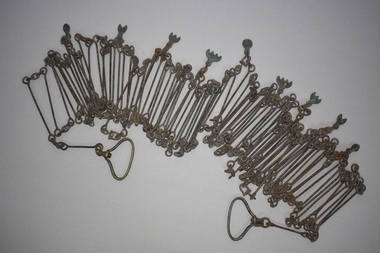
Chain link measure, Gunter's Chain, 19th Century
... Gunter’s Chain Land Measurement Tools history of warrnambool This is a metal tool which consists of 100 metal pieces or links joined together by loops at each end with two metal loops in between each link. The links joined together form a chain. The two ends of the chain have small metal handles attached. At intervals along the chain there are additional ...A Gunter’s Chain, an old land surveying instrument, is named after its inventor, Edmund Gunter (1581-1626), an English mathematician and astronomer. It was first produced in 1620. The tool has 100 links and is 66 feet or one chain long. The links are marked off in groups of ten by metal tags or rings. A quarter chain (25 links) is called a rod or pole and ten chains make a furlong and 80 chains a mile. The traditional cricket pitch is 22 yards or one chain long. This chain is said to have been used by Gilbert Nicol when the Warrnambool to Hamilton Road was constructed in the 19th century. Gilbert Nicol was an early settler in Warrnambool who, with John Craig, established the first hotel (and the first building) in Warrnambool in 1847. Nicol later owned the property ‘Rosehill’ in the Warrnambool area. As the chain was given to the Warrnambool and District Historical Society by the Town Clerk, Keith Arnel, it is likely that the chain was one of the items in the old Warrnambool MuseumThis Gunter’s Chain is of importance because it is an early land measuring device that was used for over 250 years and has great historical and mathematical significance. If it is correct that it was used by Gilbert Nicol when the Warrnambool to Hamilton Road was built then it has considerable local significance and dates back to the 19th century. This is a metal tool which consists of 100 metal pieces or links joined together by loops at each end with two metal loops in between each link. The links joined together form a chain. The two ends of the chain have small metal handles attached. At intervals along the chain there are additional rings or metal pieces attached. The metal is very rusted.gunter’s chain, land measurement tools, history of warrnambool -
 Warrnambool and District Historical Society Inc.
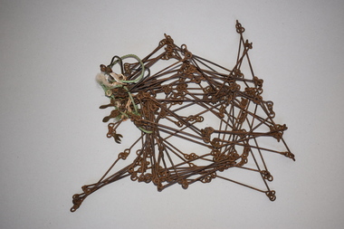
Chain link measure, Gunter, Early 20th century
... It has a possible local connection as it was given to the Historical Society by a local person in 1965 and possibly came from the property of ‘Rosehill’ Gunter’s Chain Land Measurement Tools History of Warrnambool This is a metal tool which consists of 100 metal pieces or links joined together by loops at each end with two metal loops in between each link. The links joined together form a chain. The two ends of the chain have small metal handles attached At intervals along the chain there are additional ...This Gunter’s Chain, an old land surveying instrument, is named after its inventor, Edmund Gunter (1581-1626), an English mathematician and astronomer. It was first produced in 1620. The tool has 100 links and is 66 feet or one chain long. The links are marked off in groups of ten by metal rings or tags. A quarter chain (25 links) is called a rod or pole and ten chains make a furlong and 80 chains make a mile. The traditional cricket pitch is 22 yards or one chain long. This Gunter’s Chain is of considerable significance because: 1. It is an early land measuring tool that was used for over 250 years and has great historical and mathematical significance. A Gunter’s Chain would have been used when forming and building local roads from the earliest days of settlement. 2. It has a possible local connection as it was given to the Historical Society by a local person in 1965 and possibly came from the property of ‘Rosehill’ This is a metal tool which consists of 100 metal pieces or links joined together by loops at each end with two metal loops in between each link. The links joined together form a chain. The two ends of the chain have small metal handles attached At intervals along the chain there are additional rings or metal pieces attached. Some white and green rope material has been used to bundle up the chain. The metal is somewhat rusted. gunter’s chain, land measurement tools, history of warrnambool -
 Warrnambool and District Historical Society Inc.
Book, Welsh Bible, 1864
... land "Acme" farm. Their other children Margaret, Jane, Evan, Lewis and Elizabeth were born there." The Memorial card provides the additional information that Sarah Morgan died July 30th 1906 at the age of 68. ...land "Acme" farm. Their other children Margaret, Jane, Evan, Lewis and Elizabeth were born there." The Memorial card provides the additional information that Sarah Morgan died July 30th 1906 at the age of 68. ...As written in the note inserted in the front of the bible ,"This Welsh Bible was brought to Australia by John Morgan and his wife Sarah in 1865. With baby daughter Mary, they settled at Allansford, where John took up land "Acme" farm. Their other children Margaret, Jane, Evan, Lewis and Elizabeth were born there." The Memorial card provides the additional information that Sarah Morgan died July 30th 1906 at the age of 68. The date of the Bible 1864 fits with their arrival in Australia in 1865. The Morgan family have been connected to Allansford from that time. This bible has significance social and historical significance as the Bible was common in many family homes. This one written in Welsh shows the connection between the origins of the Morgan family and their new country. It is well provenanced and is well connected to the district.Dark brown leather cover over card.The pages are edged in gold and the front and and back covers have a rectangular scrolled design . The pages are not numbered.There is an envelope inside the front cover with a George Hose docket for threshing wheat, barley and oats and an In Memoriam card for Sarah Morgan who dies July 30th 1906. There is also a handwritten note with the owners details and a navy ribbon which may have been attached at one time.There are no inscriptions on the bible itself but the handwritten card reads, " This Welsh Bible was brought to Australia by John Morgan and his wife Sarah in 1865. With baby daughter Mary, they settled at Allansford, where John took up land"Acme" farm. Their other children Margaret, Jane, Evan, Lewis and Elizabeth were born there. There is also an envelope dated 2004 and addressed to Mr Bill Morgan 6 Vera St Iluka NSW 2466. Watkins Binder label inside the back cover.allansford, welsh bible, morgan family, sarah and john morgan -
 Bendigo Military Museum
Pamphlet - Manual of Land Warfare - Employment of RASvy - Survey Training, School of Military Survey, Bonegilla, Vic, 1984
... Land Warfare Volume 1, Phamphlet No1 - Employment of RASvy - Part 2, Survey Training 1984. The pamphlet describes the responsibilities and principles of employment of RASvy units and elements in the area of operations and in the support area. It outlines the roles, characteristics and tasks of RASvy units and elements, but no attempt has been made to detail staff or technical procedures. The document being a draft, contains many blank pages for additional...Land Warfare Volume 1, Phamphlet No1 - Employment of RASvy - Part 2, Survey Training 1984. The pamphlet describes the responsibilities and principles of employment of RASvy units and elements in the area of operations and in the support area. It outlines the roles, characteristics and tasks of RASvy units and elements, but no attempt has been made to detail staff or technical procedures. The document being a draft, contains many blank pages for additional ...This document is a draft proposal by the School of Military Survey (SMS) for the Manual of Land Warfare Volume 1, Phamphlet No1 - Employment of RASvy - Part 2, Survey Training 1984. The pamphlet describes the responsibilities and principles of employment of RASvy units and elements in the area of operations and in the support area. It outlines the roles, characteristics and tasks of RASvy units and elements, but no attempt has been made to detail staff or technical procedures. The document being a draft, contains many blank pages for additional information to be added prior to publication. RASvy was disbanded in 1996.45 x page A4 paper pamphlet containing text and diagrams. Buff coloured light card covers with a plastic comb binding.On the front cover: "A 7610 -14 - 1332" "As proposed by SMS April 1985"royal australian survey corps, rasvy, fortuna, army survey regiment, army svy regt, asr, school of military survey -
 Bendigo Military Museum
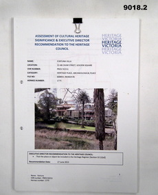
Document - Heritage Victoria Assessment of Cultural Heritage - Fortuna Villa, Heritage Victoria, October 2013
... additional information in red. Fortuna Villa was the family home of George Lansell the "Gold King" of Bendigo prior to being occupied by the Australian Army's Land Headquarters Cartographic Coy in WWII from 1942. ...additional information in red. Fortuna Villa was the family home of George Lansell the "Gold King" of Bendigo prior to being occupied by the Australian Army's Land Headquarters Cartographic Coy in WWII from 1942. ...These documents 9018.1 and .2 discuss the significant Cultural Heritage value of Fortuna Villa and is a report regarding the acceptance of the Heritage Values by the Heritage Council of Victoria. 9018.2 while almost identical to 9018.1 in content does have additional information in red. Fortuna Villa was the family home of George Lansell the "Gold King" of Bendigo prior to being occupied by the Australian Army's Land Headquarters Cartographic Coy in WWII from 1942. The Army Survey Regiment was disbanded in 1996 and Defence left the site in 2004..1 A A4 Paper Heritage Report of Fortuna Villa. 26 x Pages of the Assessment part of the document, further 24 x Pages are the City of Greater Bendigo discussions of Heritage permit Exemptions. The document is two hole punched and held together with a metal Arnos fastener. .2 A second copy of the document containing 32 x unnumbered loose Pages held together with a small "bulldog" clip. Name Fortuna, VHR Number : PROV H2211, Hermes Number 1775royal australian survey corps, rasvy, fortuna, army survey regiment, army svy regt, asr, heritage victoria -
 Kiewa Valley Historical Society
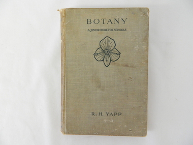
Book - Reference Botany, Botany - A Junior Book For Schools, 1927
... This in one way provided students in the valley a slightly better appreciation between book and real life (on the land, in the field and by the river). Later publications of this book had additional Australian references in them. school botany text books science experiments nature On spine "BOTANY" underneath "R.H. ...This book was a highly regarded reference book for students in primary and lower secondary schools within Victoria from the late 1800s to the mid 1900s. The book provided students with the fundamental knowledge of botany for the era in which it was produced. As this book was targeting a junior schooling level (basic), it could cover a greater and extended reader population. Teaching institutions could, because of its straight forward, basic written information, retain this book's circulation for a greater length of time, thereby optimising the return against the greater initial costs of importing it from England.This book was produced in a time where learning was at a relatively slower pace (due to a smaller source and supply of material). The availability of a large range of cheap reference books such as that offered from 1971 on wards via the internet "Project Guttenberg" in the form of electronic books, has dramatically provided a larger source of reference material. The significance of this book on botany, is that it was highly effective for the era in which it was produced and in particular the students at a rural based school. Being in a rural area students were able to identify local vegetation to the various life cycles of plants presented in this mainly United Kingdom/European referenced book. The students in the Kiewa Valley and attending a rural school, where in a position to study all the fundamental teaching that this book encompassed. This in one way provided students in the valley a slightly better appreciation between book and real life (on the land, in the field and by the river). Later publications of this book had additional Australian references in them.This hard covered book(cloth strengthened) is faded(aged) beige in colour and consists of 204 pages. It is printed in English (black print) on both sides and contains illustrations of both free hand sketches and photographs of plants, both foliage and roots systems. The book is arranged in three sections: three pages of preface, two of contents (28 chapters). The last four pages contain the appendix and index.On spine "BOTANY" underneath "R.H. YAPP" and at bottom the Cambridge coat of Arms and below this "CAMBRIDGE" The front cover "BOTANY" underneath this "A JUNIOR BOOK FOR SCHOOLS" and below this a an illustration of a four leaf petal(flower of Germander Speedwell) the same as appears on the cover of edition 2, however this book is edition 3. At the bottom is "R.H. YAPPschool, botany, text books, science experiments, nature -
 Bendigo Military Museum
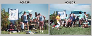
Photograph - Army Survey Regiment Inter-Squadron Athletics Competition - Set 2, Bendigo, 1990
... additional photos taken during the Athletics Event. Royal Australian Survey Corps RASvy Army Survey Regiment Army Svy Regt Fortuna No personnel are identified. This is a set of 30 photographs of an Army Survey Regiment inter-squadron athletics competition held at Bendigo in 1990. The photographs are on 35mm negative film and were scanned at 2400 dpi. They are part of the Army Survey Regiment’s Collection. .1) - Photo, colour, 1990, Air Survey Squadron HQ, L to R: John Shephard, unidentified, Noel McNamara - obscured, Tony Grivel – facing away, Bruce Hammond, Mark Lander ...This is a set of 30 photographs of an Army Survey Regiment inter-squadron athletics competition held at Epsom, Bendigo in 1990. Personnel from Headquarters, Air Survey, Cartographic and Lithographic Squadrons took part in traditional athletics events, wheelbarrow race, sack race, fireman’s carry and tug-of-war novelty events.’ Air Survey Squadron’s team was bolstered with members from Adelaide’s 4th Field Survey Squadron. Refer to items 9088.32P - Set 1 and 9090.31P -Set 3 for additional photos taken during the Athletics Event.This is a set of 30 photographs of an Army Survey Regiment inter-squadron athletics competition held at Bendigo in 1990. The photographs are on 35mm negative film and were scanned at 2400 dpi. They are part of the Army Survey Regiment’s Collection. .1) - Photo, colour, 1990, Air Survey Squadron HQ, L to R: John Shephard, unidentified, Noel McNamara - obscured, Tony Grivel – facing away, Bruce Hammond, Mark Lander, Andy Love, Chris ‘Charlie’ Brown, Doug Willis – facing away. .2) - Photo, colour, 1990, Air Survey Squadron HQ, L to R: Janette Dury-Lane, Chris ‘Charlie’ Brown, Peter Peterson, Paul Hopes, Mark Lander, Stuart Bowd, Noel Brinsmead. .3) - Photo, colour, 1990, Lithographic Squadron ‘brothers’ L to R: Peter Imerson, Trevor Osborne, Bob Coote, Rhys De Laine. .4) - Photo, colour, 1990, Lithographic Squadron ‘brothers’ L to R: Cameron Kelly, Scott Cameron, Steve Burke, Andrew Morrison-Evans. .5) - Photo, colour, 1990, Relay Race, foreground L to R: Laurie Justin, Peter Imeson. Background L to R: John Reid, Stuart Thaxter, Geoff Webb. .6) - Photo, colour, 1990, Relay Race, L to R: Terry King, Ian Fitzgerald. .7) - Photo, colour, 1990, Relay Race, Bob Coote. .8) - Photo, colour, 1990, officials conferring in foreground L to R: Ian Nelson, Fred Cowie, unidentified. Background L to R: Paul Richards, Brian Collings, Ian ‘Rock’ Thistleton. .9) & .10) - Photo, colour, 1990, Peter Imerson. .11) - Photo, colour, 1990, Wheelbarrow Race, L to R: Steve Hansen, Noel ‘Nesty’ Coulthard, Stuart Thaxter. .12) - Photo, colour, 1990, Wheelbarrow Race, L to R: Ken ‘Sluggo’ Slater, Ray Redman, Steve Hansen, Noel ‘Nesty’ Coulthard, Stuart Thaxter, Steve Wegener, unidentified, Neil Taylor, Graham Ragless, Gary Warnest, Chris Wynn, Bill Jones, Marty Lyons, Rob Bogumil, Dave McLachlan. .13) - Photo, colour, 1990, Wheelbarrow Race, L to R: Ken ‘Sluggo’ Slater, Steve Hledik, Bob Coote, Steve Hansen, unidentified, Bill Jones, Neil Taylor. .14) - Photo, colour, 1990, Wheelbarrow Race, L to R: Marty Lyons, Rob Bogumil. .15) - Photo, colour, 1990, Wheelbarrow Race, L to R: Neil Taylor, Graham Ragless, Ray Redman, Steve Hansen. .16) - Photo, colour, 1990, Wheelbarrow Race, L to R: Bob Coote, Neil Taylor, Graham Ragless, Gary Warnest, Marty Lyons, Rob Bogumil, Dave McLachlan, Bill Jones. .17) - Photo, colour, 1990, Wheelbarrow Race, L to R: Bob Coote, Bill Jones. .18) - Photo, colour, 1990, Wheelbarrow Race, L to R: Gary Warnest, Terry Lord, Stuart Thaxter, Noel ‘Nesty’ Coulthard. .19) - Photo, colour, 1990, teams prepare for Tunnelball event. Andy Lucas at far right. .20) - Photo, colour, 1990, Carto Sqn Team Banner. At front L to R: unidentified, Steve Wegener. At rear L to R: Jodie Seath, Steve Wainwright. Grant Davis at left of umbrella.in background. .21) - Photo, colour, 1990, Tunnelball. Left team L to R: Steve Hansen, unidentified (x4), Paul ‘Fluff’ Cheater, Wayne Rothwell. Centre team L to R: Noel ‘Macca’ McNamara – with medicine ball, Stuart Symonds, Neil ‘Ned’ Kelly, John Shephard, Allan Hancox, Bruce Hammond. Right team: all unidentified. .22) - Photo, colour, 1990, Tunnelball. Left team: Neil ‘Ned’ Kelly. Centre team L to R: unidentified, Peter Dillon, Greg Howell, Peter Breukel, Frank Lenane, Steve Egan, Darren ‘Barney’ Maher. Right team: Barry Hogan. .23) - Photo, colour, 1990, Tunnelball. Left team L to R: Frank Lenane, remainder unidentified. Right team L to R: Grant Davis – with medicine ball, Dan Cirsky, Bob Bright, Barry Hogan, Rick van der Bom. Spectators L to R: unidentified, Kevin ‘Chuck’ Berry, Chris Wynn. .24) - Photo, colour, 1990, Tunnelball, Litho/Air Survey Team front to back: Janet Murray, Paula (Golding) Brinsmead, remainder unidentified. .25) - Photo, colour, 1990, Tunnelball, Litho/Air Survey Team front to back: Janet Murray, Dawn Hoadley, Shona Hastie, Tracy Tillman. .26) - Photo, colour, 1990, Tunnelball, spectators L to R: unidentified, Brendan McKinless, Penny Knott, unidentified. Carto Team L to R: Cam Bramich, Sandy Winn, Jeanette Drury-Lane, Caroline (Wyatt) Evans, Del Madge, remainder unidentified. .27) - Photo, colour, 1990, Tunnelball, spectators L to R: Brendan McKinless Dawn Hoadley. Carto Team L to R: Cam Bramich, Sandy Winn, Jeanette Drury-Lane, remainder unidentified. Sue (Foote) Bourne – with medicine ball. .28) - Photo, colour, 1990, Tunnelball, spectators L to R: unidentified photographer, Brendan McKinless, Carto Team front to back: Raelene (Munting) Brodie, Jeanette Drury-Lane, Sandy Winn, unidentified, Sue (Foote) Bourne, Charmain McKean, Del Madge, Simone Rodgers – with medicine ball. .29) - Photo, colour, 1990, Tunnelball, Carto Team back row L to R: Sandy Winn, Cam Bramich, Jeanette Drury-Lane, Del Madge, Charmain McKean. Front row L to R: Sue (Foote) Bourne, Simone Rodgers – with medicine balls. .30) - Photo, colour, 1990, Women participants back row L to R: Sue (Foote) Bourne, unidentified, Sandy Winn, Nadine (Paul) Read, Simone Rodgers, Craig Kellet – in drag, Del Madge, Janet Murray, Charmain McKean, Caroline (Wyatt) Evans. Cam Bramich, Raelene (Munting) Brodie, Sherri (Dally) Burke. Front row L to R: Shona Hastie, Jo Otto, Paula (Golding) Brinsmead, Jodi Seath, Dawn Hoadley, Tracy Tillman. Penny Knott.No personnel are identified.royal australian survey corps, rasvy, army survey regiment, army svy regt, fortuna -
 Bendigo Military Museum
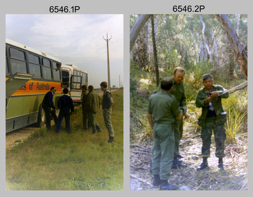
Photograph - 4th Field Survey Squadron Adventurous Training Mount Remarkable National Park, SA, 4th Field Survey Squadron Adventurous Training, Mount Remarkable National Park, SA, 1987
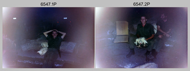
... land survival skills. Elements from units of the Army Reserve also participated in the training. Refer to items 6547.40P and 6548.14P for additional photographs taken during the adventurous training....land survival skills. Elements from units of the Army Reserve also participated in the training. Refer to items 6547.40P and 6548.14P for additional photographs taken during the adventurous training. ...This is a set of 42 photographs of 4th Field Survey Squadron undergoing adventurous training at Mount Remarkable National Park, South Australia in May 1987. It is evident the training focussed on teamwork, leadership, abseiling, rock climbing, field craft and living off the land survival skills. Elements from units of the Army Reserve also participated in the training. Refer to items 6547.40P and 6548.14P for additional photographs taken during the adventurous training.This is a set of 42 photographs of 4th Field Survey Squadron undergoing adventurous training at Mount Remarkable National Park in May 1987. The colour photographs are on 35mm negative film and are part of the Army Survey Regiment’s Collection. The photographs were scanned at 96 dpi. .1) - Photo, colour, 1987. L to R: unidentified bus drivers, CAPT Danny Galbraith, unidentified, SGT Stu Symonds. .2) - Photo, colour, 1987. L to R: OC MAJ Peter Cates, SSM WO1 Bill Grigg, unidentified exchange officer. .3) - Photo, colour, 1987. Squadron briefing. .4) - Photo, colour, 1987. Endurance march L to R: unidentified (x4), LCPL Peter McCurdy, unidentified (x3), SPR Damien Killeen, unidentified. .5) - Photo, colour, 1987. Unidentified personnel taking a break during or at end Endurance march. SPR John Keely at far right. .6) - Photo, colour, 1987. Mount Remarkable National Park terrain. .7) - Photo, colour, 1987. Mount Remarkable National Park terrain. SGT Peter Imeson. .8) - Photo, colour, 1987. Mount Remarkable National Park terrain. CPL Jeff Prince. .9) - Photo, colour, 1987. Camp activities. CPL Dave Irving. .10) - Photo, colour, 1987. Camp activities. L to R: unidentified, SPR Perry Langeberg, unidentified (x2), CPL Neale ‘Tex’ Houston, SPR Steve Ellis. .11) to .13) - Photo, colour, 1987. Mount Remarkable National Park terrain. .14) - Photo, colour, 1987. Camp activities. Unidentified. .15) - Photo, colour, 1987. Camp activities. L to R: PTE P. Simpson, SPR Steve Ellis. .16) - Photo, colour, 1987. Hootchie set-up. Unidentified personnel. .17) - Photo, colour, 1987. Hootchie set-up. .18) - Photo, colour, 1987. Camp activities. Unidentified. .19) - Photo, colour, 1987. Camp activities. L to R: SPR Todd Hayley, CPL Jamie McRae. .20) - Photo, colour, 1987. Camp activities. L to R: unidentified, CPL Neale ‘Tex’ Houston, unidentified. .21) - Photo, colour, 1987. Camp activities. L to R: CPL Dave Longbottom, WO2 Brett ‘Dutchy’ Van Leeuwen. .22) - Photo, colour, 1987. Hootchie set-up. .23) - Photo, colour, 1987. Hootchie set-up. CPL Dave Irving. .24) - Photo, colour, 1987. Mount Remarkable National Park terrain. Possibly OC MAJ Peter Cates. .25) - Photo, colour, 1987. Mount Remarkable National Park terrain. .26) & .27) - Photo, colour, 1987. Hootchie set-up. .28) - Photo, colour, 1987. Camp activities. CPL Roger Graf. .29) - Photo, colour, 1987. Camp activities. Possibly water sterilisation. .30) - Photo, colour, 1987. Camp set-up. Unidentified. .31) - Photo, colour, 1987. Hootchie interior. .32) - Photo, colour, 1987. CAPT Danny Galbraith. .33) - Photo, colour, 1987. Camp activities. L to R: LCPL Peter Tuddenham, SPR Todd Hayley, CPL Dave Longbottom, CPL John Ratcliffe, CPL Dave Irving. .34) - Photo, colour, 1987. Hootchie set-up. .35) - Photo, colour, 1987. Hootchie set-up. CPL Peter Hardy. .36) - Photo, colour, 1987. Camp activities. L to R: unidentified (x2), CPL Peter Hardy, LT Greg Oaten. .37) - Photo, colour, 1987. Camp activities. L to R: SPR Shaun Hynes, LT Geoff ‘GT’ Ford, SPR Bruce Graham, unidentified (x2). .38) - Photo, colour, 1987. Camp activities. L to R: SPR Shaun Hynes, LT Geoff ‘GT’ Ford, unidentified, SPR Bruce Graham, in background - CPL Dave Irving. .39) - Photo, colour, 1987. Hootchie set-up. Unidentified. .40) - Photo, colour, 1987. Camp activities. WO2 Brett ‘Dutchy’ Van Leeuwen. .41) & .42) - Photo, colour, 1987. Camp activities. Results from foraging the forest for food..1P to .42P – There are no personnel identified. ‘1987 ADV TRAINING’ annotated on negatives sleeve.royal australian survey corps, rasvy, 4 fd svy sqn -
 Bendigo Military Museum
Photograph - 4th Field Survey Squadron Adventurous Training, Mount Remarkable National Park, Flinders Ranges, SA, 4th Field Survey Squadron Adventurous Training, Mount Remarkable National Park, SA, 1987
... land survival skills. Elements from units of the Army Reserve also participated in the training. Refer to items 6546.42P and 6548.14P for additional photographs taken during the adventurous training....land survival skills. Elements from units of the Army Reserve also participated in the training. Refer to items 6546.42P and 6548.14P for additional photographs taken during the adventurous training. ...This is a set of 40 photographs of 4th Field Survey Squadron undergoing adventurous training at Mount Remarkable National Park, South Australia in May 1987. It is evident the training focussed on teamwork, leadership, abseiling, rock climbing, field craft and living off the land survival skills. Elements from units of the Army Reserve also participated in the training. Refer to items 6546.42P and 6548.14P for additional photographs taken during the adventurous training.This is a set of 40 photographs of 4th Field Survey Squadron undergoing adventurous training at Mount Remarkable National Park, South Australia in May 1987. The colour photographs are on 35mm negative film and are part of the Army Survey Regiment’s Collection. The photographs were scanned at 96 dpi. .1) - Photo, colour, 1987. Camp activities, unidentified soldier. .2) - Photo, colour, 1987. Camp activities, unidentified personnel. .3) & .4) - Photo, colour, 1987. Hootchie set-up. .5) - Photo, colour, 1987. Camp activities, unidentified personnel. .6) - Photo, colour, 1987. Hootchie set-up. .7) - Photo, colour, 1987. Camp activities. .8) - Photo, colour, 1987. Hootchie set-up, unidentified officer. .9) - Photo, colour, 1987. Camp activities. Results from foraging the forest for food. .10) - Photo, colour, 1987. Camp set-up. .11) - Photo, colour, 1987. Camp activities. .12) - Photo, colour, 1987. Camp activities. L to R: CPL Jeff Prince, unidentified (x3). .13) to .16) - Photo, colour, 1987. Camp activities. .17) & .18) - Photo, colour, 1987. Mount Remarkable National Park terrain. .19) - Photo, colour, 1987. Hootchie set-up. L to R: unidentified, CPL Jeff Prince, SPR Perry Langeberg, unidentified (x3). .20) - Photo, colour, 1987. Camp activities. .21) - Photo, colour, 1987. Camp activities, unidentified personnel. .22) & .23) - Photo, colour, 1987. Camp set-up. .24) - Photo, colour, 1987. Hootchie set-up. .25) - Photo, colour, 1987. Hootchie set-up, unidentified personnel. .26) - Photo, colour, 1987. Camp activities. L to R: CPL Jeff Prince, SPR Steve Ellis, SGT Peter Imeson, CPL Neale ‘Tex’ Houston, SPR Perry Langeberg, unidentified exchange officer, WO2 Russ Larsen. .27) - Photo, colour, 1987. Hootchie set-up. .28) - Photo, colour, 1987. Camp activities. L to R: SPR Bruce Graham, LT Geoff ‘GT’ Ford, CPL Jamie ‘Fish’ McRae, SGT Wally Chilcott, SPR Shaun Hynes, CPL Kevin Whitty. .29) - Photo, colour, 1987. Camp activities. L to R: unidentified, SPR Todd Hayley, unidentified, WO2 Peter Symmans, SSGT Cam Chapman, CPL Dave Irving. .30) - Photo, colour, 1987. Camp activities. L to R: unidentified (x2), LT Greg Oaten, unidentified (x2), CPL Peter Hardy, unidentified. .31) - Photo, colour, 1987. Camp activities. L to R: CPL Roger Graf, WO2 Bob Rogister, SSM WO1 Bill Griggs, unidentified officer, SPR Simon Reynolds, SPR John Keely. .32) - Photo, colour, 1987. Camp activities. L to R: unidentified, SPR Steve Nokes, SGT Stu Symonds, WO2 Brett ‘Dutchy’ Van Leeuwen, unidentified (x3). .33) - Photo, colour, 1987. Camp activities. L to R: unidentified, SGT Derek Stanmore, CAPT Danny Galbraith, unidentified in foreground. .34) - Photo, colour, 1987. Camp activities. L to R: unidentified (x3), SGT Derek Stanmore, CAPT Danny Galbraith. .35) - Photo, colour, 1987. Camp activities. .36) - Photo, colour, 1987. Camp activities. OC MAJ Peter Cates. .37) - Photo, colour, 1987. Camp activities. L to R: unidentified, CPL Dave Longbottom. .38) - Photo, colour, 1987. Camp activities, unidentified personnel. .39) & .40) - Hootchie set-up..1P to .40P – There are no personnel identified. ‘1987 ADV TRAINING’ annotated on negatives sleeve.royal australian survey corps, rasvy, 4 fd svy sqn -
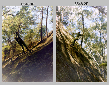 Bendigo Military Museum
Photograph - 4th Field Survey Squadron Adventurous Training, Wilpena pound, Flinders Ranges, SA, 1987
... land survival skills. Elements from units of the Army Reserve also participated in the training. Refer to items 6546.42P and 6547.40P for additional photographs taken during the adventurous training exercise....land survival skills. Elements from units of the Army Reserve also participated in the training. Refer to items 6546.42P and 6547.40P for additional photographs taken during the adventurous training exercise. ...This is a set of 14 photographs of a 4th Field Survey Squadron undergoing an abseiling activity, as part of adventurous training held at Mount Remarkable National Park, South Australia in May 1987. It is evident the training focussed on teamwork, leadership, abseiling, rock climbing, field craft and living off the land survival skills. Elements from units of the Army Reserve also participated in the training. Refer to items 6546.42P and 6547.40P for additional photographs taken during the adventurous training exercise.This is a set of 14 photographs of 4th Field Survey Squadron personnel undergoing an abseiling activity, as part of 4th Field Survey Squadron adventurous training held at Mount Remarkable National Park of South Australia in May 1987. The colour photographs are on 35mm negative film and are part of the Army Survey Regiment’s Collection. The photographs were scanned at 96 dpi. .1) - Photo, colour, 1987. Abseiling activities, SSM WO1 Bill Griggs. .2) to .14) - Photo, colour, 1987. Abseiling activities, unidentified soldier..1P to .14P – There are no personnel identified. ‘1987 ADV TRAINING’ annotated on negatives sleeve.royal australian survey corps, rasvy, 4 fd svy sqn -
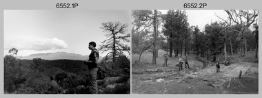 Bendigo Military Museum
Photograph - 4th Field Survey Squadron Adventurous Training, Wilpena pound, Flinders Ranges, SA, 1989
... land survival skills. Elements from units of the Army Reserve also participated in the training. In this photo set, one of 4th Field Survey’s sections participated in abseiling and trekked to the highest mountain in the Flinders Ranges – St. Mary’s Peak. Refer to items 6553.56P for additional...land survival skills. Elements from units of the Army Reserve also participated in the training. In this photo set, one of 4th Field Survey’s sections participated in abseiling and trekked to the highest mountain in the Flinders Ranges – St. Mary’s Peak. Refer to items 6553.56P for additional ...This is a set of 43 photographs of a 4th Field Survey Squadron adventurous training held at Wilpena pound, in the Flinders Ranges of South Australia in 1989. It is evident the training focussed on teamwork, leadership, abseiling, rock climbing, field craft and living off the land survival skills. Elements from units of the Army Reserve also participated in the training. In this photo set, one of 4th Field Survey’s sections participated in abseiling and trekked to the highest mountain in the Flinders Ranges – St. Mary’s Peak. Refer to items 6553.56P for additional colour photographs taken during the adventurous training exercise.This is a set of 43 photographs of 4th Field Survey Squadron personnel undergoing adventurous training held at Wilpena pound, in the Flinders Ranges of South Australia in 1989. The black & white photographs are on 35mm negative film and are part of the Army Survey Regiment’s Collection. The photographs were scanned at 96 dpi. .1) - Photo, black & white, 1989. L to R: SGT Laurie Justin, SGT Stu Symonds. .2) - Photo, black & white, 1989. L to R: SGT Stu Symonds, CPL Roger Graf, SSGT Max Coletti, SPR Cheryl Deluca-Cardillo, SPR Andrew Quin. .3) & .4) - Photo, black & white, 1989. Wilpena Pound topography. .5) - Photo, black & white, 1989. SGT Stu Symonds. .6) - Photo, black & white, 1989. Abseiling ropes and equipment. .7) to .16) - Photo, black & white, 1989. Abseiling activities, unidentified soldier. .17) to .18) - Photo, black & white, 1989. Abseiling activities, CPL Michelle Griffith. .19) - Photo, black & white, 1989. L to R: unidentified (x5), SGT Mick Hogan, unidentified (x3). .20) - Photo, black & white, 1989. L to R: CPL Roger Graf, CPL Michelle Griffith, SPR Cheryl Deluca-Cardillo, SGT Laurie Justin, SSGT Max Coletti, SPR Andrew Quin. SGT Stu Symonds. .21) - Photo, black & white, 1989. L to R: unidentified (x2), SGT Stu Symonds. .22) & .23) - Photo, black & white, 1989. Wilpena Pound topography. .24) - Photo, black & white, 1989. SSGT Max Coletti. .25) - Photo, black & white, 1989. SSGT Max Coletti, SPR Cheryl Deluca-Cardillo, SGT Stu Symonds. .26) - Photo, black & white, 1989. SGT Stu Symonds. .27) - Photo, black & white, 1989. L to R: CPL Michelle Griffith, SPR Cheryl Deluca-Cardillo, SSGT Max Coletti, SGT Laurie Justin, SPR Andrew Quin, CPL Roger Graf, SGT Stu Symonds. .28) &.29) - Photo, black & white, 1989. Wilpena Pound topography. .30) - Photo, black & white, 1989. SGT Stu Symonds. .31) - Photo, black & white, 1989. CPL Michelle Griffith. .32) - Photo, black & white, 1989. L to R: CPL Michelle Griffith, SGT Stu Symonds, SSGT Max Coletti, SGT Laurie Justin. .33) - Photo, black & white, 1989. L to R: CPL Michelle Griffith, SGT Stu Symonds, CPL Roger Graf (standing), SSGT Max Coletti, SGT Laurie Justin. .34) - Photo, black & white, 1989. L to R: SGT Stu Symonds, CPL Michelle Griffith, CPL Roger Graf (standing), SSGT Max Coletti, SGT Laurie Justin. .35) to .37) - Photo, black & white, 1989. Wilpena Pound topography. .38) - Photo, black & white, 1989. SPR Cheryl Deluca-Cardillo. .39) - Photo, black & white, 1989. L to R: CPL Michelle Griffith, SGT Stu Symonds, SPR Andrew Quin, SGT Laurie Justin. .40) &.41) - Photo, black & white, 1989. Wilpena Pound topography. .1P to .43P – There are no personnel identified. ‘1989 ADV TRAINING’ annotated on negatives sleeve.royal australian survey corps, rasvy, 4 fd svy sqn -
 Eltham District Historical Society Inc
Photograph - Digital Photograph, Jim Connor, Edendale Farm Homestead, 11 December 2014
... Cool did not farm the land, instead using it as a gentleman’s residence, retiring to Eltham at weekends. In 1918 he purchased an additional 7 acres but in 1919 he sold the property. ...Cool did not farm the land, instead using it as a gentleman’s residence, retiring to Eltham at weekends. In 1918 he purchased an additional 7 acres but in 1919 he sold the property. ...Edendale Farm is Nillumbik Shire Council's environment centre situated in Gastons Road, Eltham between the railway and the Diamond Creek. The homestead on the property was built in 1896 and is of historical significance, being the subject of a Heritage Overlay under the Nillumbik Planning Scheme. The Edendale property was originally part of an extensive land purchase in 1852 from the Crown by pioneer Eltham farmer Henry Stooke. He initially purchased 51 acres and later expanded his holdings by purchasing another three adjacent Crown allotments extending northerly from Josiah Holloway's Little Eltham subdivision. Despite clearing the land, Stooke did not build on this property, choosing to live on his property "Rosehill" at Lower Plenty. In 1896 Thomas Cool, Club Manager of the Victoria Coffee Palace in Melbourne purchased 7 acres of the original Stooke land and built the house now known as Edendale. Cool did not farm the land, instead using it as a gentleman’s residence, retiring to Eltham at weekends. In 1918 he purchased an additional 7 acres but in 1919 he sold the property. Later owners included J.W. Cox, the Gaston family and D. Mummery. In the 1980s the Eltham Shire Council purchased the site for use as a Council depot, but this use did not proceed. Subsequently, it was used as the Council pound. The Edendale Farm Pet Education and Retention Centre was established in the summer of 1988/1989 and was set up to replace the existing dog kennels with a high standard pet retention centre. The design style of the building was established to compliment the features of the existing house. It was equipped with 10 retention pens, a veterinary room and a pet education area where school children and other interested parties learnt about pet care procedures. It was later developed into a community farm and was run by an advisory committee and in 2000 it became an Environment Centre. In early 2006 an advisory committee was established for the development of a master plan for future development at Edendale Farm. The committee included Russell Yeoman, a former long-time shire planner and founding member of the Eltham District Historical Society. At the time of filming the Master Plan and future for Edendale was about continuing to develop Edendale as a centre of environment learning and looking at expanding displays and school program, running a lot more of life-long learning and workshops around sustainable living.jim connor collection, edendale community farm, edendale farm, eltham, gastons road -
 Eltham District Historical Society Inc
Photograph, Tess Justine (Nillumbik Shire Council), Murray's Bridge over the Diamond Creek, Eltham North, 19 Feb 2022
... land either side of the creek. These were all washed away or severely damaged multiple times in the 1920s. Lessons were learnt, and Murrays Bridge appears to have been built in accordance with Country Road Board standards of the time. Flood damage was ongoing, and even more recently constructed raised bridges kept getting washed away, e.g., the new Wattle Tree Road bridge in 1958 just months after completion. Murray’s bridge was reinforced with steel some 30 years ago presumably to provide additional...land either side of the creek. These were all washed away or severely damaged multiple times in the 1920s. Lessons were learnt, and Murrays Bridge appears to have been built in accordance with Country Road Board standards of the time. Flood damage was ongoing, and even more recently constructed raised bridges kept getting washed away, e.g., the new Wattle Tree Road bridge in 1958 just months after completion. Murray’s bridge was reinforced with steel some 30 years ago presumably to provide additional ...Murray's Bridge over the Diamond Creek on the Diamond Creek Trail just prior to demolition and replacement with a new steel bridge. Heritage advice obtained by Nillumbik Shire Council, following a suggestion by the Eltham District Historical Society (EDHS), is that the original bridge appears to have been a simplified version of the Country Roads Board’s (CRB) standard timber bridge design of the early-to-mid 1920s. In c1990 Murray’s bridge was renovated with three recycled steel girders as part of a bike/pedestrian path in the reserve. During these alterations many parts of the bridge were removed, and some were replaced. Heritage advice indicates the condition of Murray’s bridge is poor. The remaining original parts are all in poor condition, with severe weathering, splitting and rot, especially to the stringers retained on the bridge. Heritage advice is that Murray’s Bridge does not have sufficient significance in the cultural history of the Nillumbik area to warrant inclusion in the Nillumbik Shire Heritage Overlay and also does not have sufficient significance as a rare survivor to warrant inclusion in the Nillumbik Shire Heritage Overlay. There are no indications in the historical record that this site was individually important to the cultural history of this area. EDHS is comfortable with the heritage advice provided to Council and has worked closely on this project with Council. EDHS has suggested some of the removed timbers be used in the vicinity of the bridge for landscaping and possibly seating, so as to retain these remnants close to the site of the original bridge, which is the last old timber bridge along the lower reaches of the Diamond Creek. Mary (Sweeney) Murray and John Wright Murray selected 80 acres, Lot C Section 16 and Lot 5 Section 17 Parish of Nillumbik, under an occupation license in 1866. John died in 1867 and freehold was granted to his son John in 1873. The farm was known as ‘Laurel Hill’. John Junior was an Eltham Shire councillor and sometime president from 1887 up until 1897. He added Lot A Section 16 to the farm in ca1888. John and his younger brother James arranged to rent/purchase Lot B Section 17, across Diamond Creek to the west, in ca1900. It appears that John and James farmed separately for a few years, with a new homestead built for James ad family on the high point of Lot B Section 17 in ca1910. John sold off Lot 5 Section 17 in 1912. When John died in 1912 James took over the land on both sides of the Diamond Creek. The old homestead on the west side of the Creek disappeared. A farm bridge over Diamond Creek from this period may have been located close to the northern boundary of the farm. John Langlands, owner of the farm known as ‘Ihurst’ on the west side of Diamond Creek to the south of the Murray’s land, died in 1907. In 1909 his land was then subdivided into 100 lots to become the ‘Glen Park Estate’. Other similar subdivisions of nineteenth century farms around Eltham in this period included the ‘Franktonia (or Beard’s) Estate’ to the northeast and ‘Bonsack’s Estate’ between Eltham and Greensborough. Soon after the opening of the railway extension line from Eltham to Hurstbridge in 1912, Glen Park and nearby residents including James Murray agitated for a railway station or siding to be located half-way between Eltham and Hurstbridge, so that the Glen Park residents who used the railway daily did not have to walk into the Eltham or Hurstbridge stations. Some believed Coleman’s Corner (opposite Edendale Farm) was an appropriate spot for the platform. James Murray was among those who thought the railway should be located on his land, closer to half-way between Eltham and Hurstbridge stations. The Railways Commissioners warned that the locals would have to fund these works themselves. The Glen Park Estate residents initially had difficulty accessing Eltham by road, with only an old low-level bridge over Diamond Creek at the south end of their estate. A new timber trestle bridge across the creek, now on Wattletree Road, was opened in 1915. Road access to the north was gained in 1927 when the new Murray’s Road, which crossed the Murray’s land, was built. Residents continued to agitate for a Glen Park station. By 1926 the Railways Commissioners’ preferred site was on the Murray’s land. They arranged an estimate of cost of a full-length platform. The estimate was too much for the locals, who in 1928 argued unsuccessfully for a shorter and hence cheaper platform. By 1929 Murray had agreed to donate the land, but the locals would still have to fund the works. Murray decided, unilaterally it would appear, to commence work on a timber trestle road bridge over Diamond Creek to link the new Murray Road to the proposed station. Late in 1929 he stopped work on the bridge, for reasons unknown, but started work again and completed the bridge in 1931. There is no further newspaper evidence of the campaign for the Glen Park station until 1939, when Murray and another local, Mr Maxwell, met the Railways Commissioner. The Glen Park locale now included 45 homes on the west side of the creek and 20 on the Eltham side. Most of the residents used the train every day. The Commissioner remained adamant that only a full-length platform could be built for safety reasons. It appears the campaign dissolved at this point. The increasing move to cars may have had an impact. There is no evidence of Murray’s bridge ever being connected to Murray’s Road, or of it having wide use for any purpose by locals. James Murray died in 1947 and the farm was taken over by his son James (Jim). Jim started to sell off parts of the farm in the 1980s, retaining a few acres around the ca1910 homestead and building a new house there. Recreation reserves were established along the creek. In ca1990 Murray’s bridge was renovated with steel girders as part of a bike/pedestrian path in the reserve. The old farmhouse was demolished in ca2014. * * * A theory posted on local community Facebook groups was that the bridge was built in the 1860s and was built to be more robust than was necessary for the movement of cows from one side of the creek to the other. It was suggested the robustness was necessary to support the weight of gold ore being transferred from a mine on Murray’s land to a railway siding near Murrays Bridge (presumably for transfer and processing at Diamond Creek). Perhaps this may have been one of the motivators for Murray, who really knows? Knowing when mining operations ceased on his land and how that fits the overall timeline would be useful but at the time the bridge was built, local gold production was minimal at best. The known facts are: • The railway line came to Eltham in 1902. • The extension of the railway from Eltham to Hurstbridge was constructed in 1912 so no railway line even existed through Murray's property until 1912 and the Victorian Railways maps at the time show no such siding on Murray’s property. • In 1923 a new company was formed in anticipation of the old Diamond Creek Gold Mine being re-opened. The mine had been previously closed and flooded. It was noted in the press at the time that the mine was within a mile of the railway. Nothing really came of this. • Construction of Murrays Bridge was commenced by James Murray in early 1929 in anticipation of a proposed flag station being nominated on his land, but work ceased shortly afterwards. The proposed flag station was commonly referred to as Glen Park as the residents of the Glen Park Estate wanted Option 1, located near them with the platform adjacent to Colemans corner. This was probably never going to fly as it was virtually in eyesight of Eltham station. Allandale Road was the third option, but the Commissioners' preferred option was No. 2 - on Murray's property. • The Railway Commissioners were not going to finance any such station and the works had to be funded by private landowners and residents, hence Murray investing in this himself. • Murray recommenced work two years later and finished his bridge in 1931 but unfortunately for him, the proposed flag station never eventuated. The bluestone siding you reference may well have been built by Murray as part of the proposed station platform. • Up until then, apart from the Main Road bridge, which was washed away in 1924, virtually all local crossings over the Diamond Creek were low lying bridges – Kaylocks Bridge at Brougham Street, Diamond Street bridge, Glen Park Road bridge. It is expected that Murray also had a low-lying bridge to connect his land either side of the creek. These were all washed away or severely damaged multiple times in the 1920s. Lessons were learnt, and Murrays Bridge appears to have been built in accordance with Country Road Board standards of the time. Flood damage was ongoing, and even more recently constructed raised bridges kept getting washed away, e.g., the new Wattle Tree Road bridge in 1958 just months after completion. Murray’s bridge was reinforced with steel some 30 years ago presumably to provide additional floodwater resistance, given the history of bridges disappearing in floodwaters. • In March 1932 it was reported in the Advertiser that there were still some prospectors operating around Eltham North who apart from further scarring the face of the earth over the previous two years had gained significant experience but little gold - hardly a driving factor for constructing a dedicated railway siding and bridge to transfer gold ore. It is far more probable that James Murray was hoping to have the railway station located on his property and invested his money by building the bridge to lead to it as well as a station platform. Had the station eventuated, it may well have driven up the value of his land for subdivision and new housing estates like the Glen Park Estate. That did not eventuate. Whilst the bridge was indeed old (90 years), the core structure being completed in 1931, it had been modified substantially from original and hence had no significant historic value – i.e., it was not a representative example of its type, construction, and age. Given that the bridge was not worthy of saving, the Eltham District Historical Society with Council’s support, and the Eltham Woodworkers group endeavoured to see what suitable sized timbers were salvageable to fabricate a commemorative seat. Unfortunately, the experts at the Woodworkers group were unable to salvage any suitable length/width timbers to fabricate the seat due to the presence of rot. Last remaining wooden trestle bridge on the Diamond Creek Trail just prior to demolition and replacementBorn digital image (27)diamond creek (creek), diamond creek trail, murrays bridge, ‘laurel hill’, john wright murray, mary (sweeney) murra, john murray jnr, james murray, john langlands, ‘ihurst’, ‘glen park estate’, beard's estate, franktonia, bonsack's estate, glen park estate, glen park railway station -
 Eltham District Historical Society Inc
Document - Report, Tract Consultants Australia Pty Ltd, Eltham Cemetery: Towards a Master Plan, Nov 1987
... land for cemetery purpose. In June of 1987, the Cemetery Trust was expanded to include additional members from the Eltham Community by the Minister for Health. ...land for cemetery purpose. In June of 1987, the Cemetery Trust was expanded to include additional members from the Eltham Community by the Minister for Health. ...BACKGROUND The Eltham Cemetery is of historic significance to the Eltham area. The Trust was established in 1858 and has administered and maintained the cemetery from that date right up to the present. Among the more noteworthy graves is that of Sir William Irvine, a former State Premier and Chief Justice of Victoria. Eltham Cemetery is surrounded on three sides by urban development. Montsalvat Artists Colony adjoins the remaining (eastern) side. A Joint Select Committee of Parliament called the “Mortuary Industry and Cemeteries Administration Committee" (MICA) enquired into the land requirements at the Eltham Cemetery in 1986. The MICA recommendations contained in its 1986 report are included in the Appendices attached to this report. Although the recommendations have not been adopted by the Government it is interesting to note that the MICA report recommended the use of the bulk of the land for cemetery purpose. In June of 1987, the Cemetery Trust was expanded to include additional members from the Eltham Community by the Minister for Health. At the same time, he instructed the Trust to resolve the land requirement issues. As a result of this Ministerial direction, Tract Consultants has been instructed by the Eltham Cemetery Trust to prepare a report addressing the issues raised in the Minister's letter (see Appendix 1) to the Trust. Principally, the study will examine options available for development of the Cemetery. These options will explore possible boundaries, cemetery design, vegetation, the overall environment, landscaping and financial planning for the Cemetery operations. Appendix 2 details the Cemetery Trusts Terms of Reference for the Study. Before commencing the study in detail, additional basic information was sought; viz: a) sub-soil and rock analysis; and b) feature survey by a Licensed Surveyor. The results from both exercises are included as appendices to this report. Section three includes a summary of the findings along with other analytical results. Also: Eltham Cemetery - planning bewteen 1859 to 1860; research by Alan Sheehan April 2015, collated by Harry Gilham, EDHS, April 2016 (2 pages) PROV Guide 5: Cemetery Records (8 pages), printed 7 May 2014Development of Eltham Cemeteryeltham cemetery trust, master plan, mica, montsalvat, mortuary industry and cemeteries administration committee, tract consultants -
Eltham District Historical Society Inc
Folder, George Fletcher, 1878
... In 1867 he selected 80 acres under the Land Act of 1865, and afterwards an additional 320 acres on Steel's Creek, where he now carries on faming and dairying. ...In 1867 he selected 80 acres under the Land Act of 1865, and afterwards an additional 320 acres on Steel's Creek, where he now carries on faming and dairying. ...Folder of information on George Fletcher, Councillor, Steels Creek, 1878. Fletcher, George, Yarra Flats was born in Herefordshire, England, in 1830, and came to Australia, landing in Adelaide, S.A. in 1851. A year afterwards he came to Victoria, but after visiting the Bendigo goldfields and other places returned to Adelaide. In 1859, he again came to Victoria, was employed on the View Hill station, Yarra Flats, and stayed there for four years. In 1867 he selected 80 acres under the Land Act of 1865, and afterwards an additional 320 acres on Steel's Creek, where he now carries on faming and dairying. During htis time Mr. Fletcher has been a member of the board of advice for the east riding of the shire of Eltham, and about twelve years ago he was elected a member of the shire council, and continued so for a term. Mr Fletcher was married in 1859, and has a family of four sons and four daughters. From "Victoria and its Metropolis: Past and Present" written in 1888 by Alexander Sutherland. Chapter 19, "The Upper Yarra District" pages [402] - 415. Page 405. Includes descriptions of some townships and short biographies of local residents. george fletcher, steels creek, pioneer -
 Eltham District Historical Society Inc
Film - Video (DVD), Nillumbik Shire Council, Edendale Farm Community Environment Centre: History, c.2009
... Cool did not farm the land, instead using it as a gentleman’s residence, retiring to Eltham at weekends. In 1918 he purchased an additional 7 acres but in 1919 he sold the property. ...Cool did not farm the land, instead using it as a gentleman’s residence, retiring to Eltham at weekends. In 1918 he purchased an additional 7 acres but in 1919 he sold the property. ...EDENDALE FARM Edendale Farm is Nillumbik Shire Council's environment centre situated in Gastons Road, Eltham between the railway and the Diamond Creek. The homestead on the property was built in 1896 and is of historical significance, being the subject of a Heritage Overlay under the Nillumbik Planning Scheme. The Edendale property was originally part of an extensive land purchase in 1852 from the Crown by pioneer Eltham farmer Henry Stooke. He initially purchased 51 acres and later expanded his holdings by purchasing another three adjacent Crown allotments extending northerly from Josiah Holloway's Little Eltham subdivision. Despite clearing the land, Stooke did not build on this property, choosing to live on his property "Rosehill" at Lower Plenty. In 1896 Thomas Cool, Club Manager of the Victoria Coffee Palace in Melbourne purchased 7 acres of the original Stooke land and built the house now known as Edendale. Cool did not farm the land, instead using it as a gentleman’s residence, retiring to Eltham at weekends. In 1918 he purchased an additional 7 acres but in 1919 he sold the property. Later owners included J.W. Cox, the Gaston family and D. Mummery. In the 1980s the Eltham Shire Council purchased the site for use as a Council depot, but this use did not proceed. Subsequently, it was used as the Council pound. The Edendale Farm Pet Education and Retention Centre was established in the summer of 1988/1989 and was set up to replace the existing dog kennels with a high standard pet retention centre. The design style of the building was established to compliment the features of the existing house. It was equipped with 10 retention pens, a veterinary room and a pet education area where school children and other interested parties learnt about pet care procedures. It was later developed into a community farm and was run by an advisory committee and in 2000 it became an Environment Centre. In early 2006 an advisory committee was established for the development of a master plan for future development at Edendale Farm. The committee included Russell Yeoman, a former long-time shire planner and founding member of the Eltham District Historical Society. At the time of filming the Master Plan and future for Edendale was about continuing to develop Edendale as a centre of environment learning and looking at expanding displays and school program, running a lot more of life-long learning and workshops around sustainable living.edendale community farm, eltham, gastons homestead, gastons road, shire of nillumbik, video recording -
 Eltham District Historical Society Inc
Photograph - Digital Photograph, Alan King, Original Kangaroo Ground Primary School No. 2105 building, Eltham-Yarra Glen Road, Kangaroo Ground, 28 December 2007
... The small playground, surrounded by pine trees and a picket fence, was extended in 1931 with an additional acre or so (0.4 ha) of land. During World War Two the school faced closure because of a fall to seven in the enrolment, but by 1946 it had increased again to 45. ...The small playground, surrounded by pine trees and a picket fence, was extended in 1931 with an additional acre or so (0.4 ha) of land. During World War Two the school faced closure because of a fall to seven in the enrolment, but by 1946 it had increased again to 45. ...Kangaroo Ground's first school began in 1851 with 22 pupils from the district's ten families. It was a single room school located further south on the site, which also served as a Presbyterian church. The first teacher was Andrew Ross. The school building was used as a Post Office between 1854 and 1858 and during 1857 also served as a Court of Petty Sessions. With a growing farming community, a new building was warranted and the original Sate School No. 352 was closed and a new building, State School No. 2105 was oipened October 1, 1878. A residence for Head Teacher Henry Wallace School was erected in 1879 attached to the left of the school building. That residence is now home to the Andrew Ross Museum, which opened in 1993. Covered under Heritage Overlay, Nillumbik Planning Scheme. Published: Nillumbik Now and Then / Marguerite Marshall 2008; photographs Alan King with Marguerite Marshall.; p35 In a corner of the Kangaroo Ground Primary School playground stands an old weatherboard building. This structure, attached to the former teacher’s weatherboard residence facing Main Road, first served as a school in 1878. The former residence, built in 1879, houses the Andrew Ross Museum, which opened in 1993. It is named after the school’s first teacher,1 who also founded The Evelyn Observer newspaper, which began on the site in 1873. Later the printing presses were moved to brick newspaper offices by the Kangaroo Ground Hotel, which became the Shire of Eltham offices. However Kangaroo Ground’s first school began in 1851 for 22 pupils from the district’s ten families, in a slab building further south on this site. Andrew Harkness and other settlers campaigned for the building, which was built on half an acre (0.2ha) donated by local farmer, James Donaldson. Builder was Samuel Furphy, father of the novelist Joseph.2 The single room measuring 30 feet x 18 feet (9m x 5.5m), was unlined and the green slabs shrank, allowing the wind and rain entry through cracks except when they were stuffed with paper.3 The building served as a Presbyterian church as well as a school, where fees were 18 pence a week for education. Young men also attended evening classes there in winter. At one stage, a corner of the room was curtained off for the schoolmaster’s living space, and the platform, which was used for sleeping, was also the pulpit during church services. Teacher Andrew Ross also took church services when the minister was unable to attend, which happened frequently as he had long distances to travel on the bad roads. In 1857 the school building was also used as the Court of Petty Sessions, and from 1854 until 1858, it served as a post office. During the gold rush fossickers on their way to the Caledonia Diggings at Queenstown (now St Andrews) prospected the district, but did not remain long, as the fields were not rich in gold. But the farming community grew, until by 1878 the population warranted the building of State School No 2105 – the present one-roomed tongue-and-groove lined building measuring 49 feet x 18 feet (15m x 5.5m), to accommodate 60 children. The old school, No 352, was closed, and the new one opened on October 1, with Henry Wallace as head teacher, assisted by work mistress Annie Johnston. Early teachers included Messrs Smith, Hamilton and Prosser, with sewing teachers Misses Sweeney, Limerock and Oliver. In the early 1920s a small room was built on the front veranda of the teacher’s residence, and used as a State Savings Bank agency until about 1934. In 1928 the schoolroom’s three-tiered floor was replaced by a flat floor and teacher’s platform (which has since been removed). A half-glassed partition wall then divided the large room into two rooms in which the old style form-type desks were replaced with dual desks. The small playground, surrounded by pine trees and a picket fence, was extended in 1931 with an additional acre or so (0.4 ha) of land. During World War Two the school faced closure because of a fall to seven in the enrolment, but by 1946 it had increased again to 45. Mr Eric Morgan was head teacher and Mrs Margaret Banks was assistant head teacher, a position she held for ten years. In 1955, under the head teacher Mr V Gardiner, who taught there for 13 years, the school won a prize for the best-kept garden and school ground in the inspectorate. A district subdivision increased the enrolment in 1968 to 65 and a bus service was established. After the hall which had been used for lessons was demolished late that year, the pupils met in the original fire brigade meeting room (now the tennis club, diagonally opposite the general store). The new school building with a storeroom and staffroom was built in 1974.This collection of almost 130 photos about places and people within the Shire of Nillumbik, an urban and rural municipality in Melbourne's north, contributes to an understanding of the history of the Shire. Published in 2008 immediately prior to the Black Saturday bushfires of February 7, 2009, it documents sites that were impacted, and in some cases destroyed by the fires. It includes photographs taken especially for the publication, creating a unique time capsule representing the Shire in the early 21st century. It remains the most recent comprehenesive publication devoted to the Shire's history connecting local residents to the past. nillumbik now and then (marshall-king) collection, kangaroo ground, andrew ross museum, eltham-yarra glen road, kangaroo ground primary school no. 2105, kangaroo ground state school, state school no. 2105 -
 Eltham District Historical Society Inc
Document - Sales Brochure, Dallas Price Homes Pty Ltd, Eltham Hub: A Unique New Entry To Eltham's Town Centre; the facts about this multi purpose development, 1996
... land, which contained the Shillinglaw Cottage (c1878-80), was the remaining section of the Shillinglaw family holding that originally comprised 30 acres, being Lot 90 of Holloway's 1851 subdivision. Eltham Council intended to demolish this cottage, but through extensive community action it was saved, funds were raised, and it was relocated to the current site adjacent to the Eltham Library. The new Eltham Shire Offices opened in 1965 were designed to ensure retention of the three Italian Cypress trees that were located outside the Shillinglaw Cottage. In 1971 the building was extended at the southern end to provide additional...land, which contained the Shillinglaw Cottage (c1878-80), was the remaining section of the Shillinglaw family holding that originally comprised 30 acres, being Lot 90 of Holloway's 1851 subdivision. Eltham Council intended to demolish this cottage, but through extensive community action it was saved, funds were raised, and it was relocated to the current site adjacent to the Eltham Library. The new Eltham Shire Offices opened in 1965 were designed to ensure retention of the three Italian Cypress trees that were located outside the Shillinglaw Cottage. In 1971 the building was extended at the southern end to provide additional ...Produced by Contour Consultants Australia Pty Ltd on behalf of Dallas Price Homes Pty Ltd as part of the planning process for redevelopment of the former Eltham Shire Office site at 895 Main Road. In 1963 the Shire of Eltham purchased the Shillinglaw property of approximately 2 acres in Main Road, Eltham for the widening of Main Road and as a site for new Council offices. This land, which contained the Shillinglaw Cottage (c1878-80), was the remaining section of the Shillinglaw family holding that originally comprised 30 acres, being Lot 90 of Holloway's 1851 subdivision. Eltham Council intended to demolish this cottage, but through extensive community action it was saved, funds were raised, and it was relocated to the current site adjacent to the Eltham Library. The new Eltham Shire Offices opened in 1965 were designed to ensure retention of the three Italian Cypress trees that were located outside the Shillinglaw Cottage. In 1971 the building was extended at the southern end to provide additional space, including for the Eltham Library and Council's Engineering Department. Renovations were undertaken to the offices during 1987. The Victorian State Government commenced to restructure local government in 1994, which resulted in the establishment of the Shire of Nillumbik and the cessation of the Shire of Eltham. This new Nillumbik Shire Council was headed by government appointed commissioners, who decided in 1995 to put the former Eltham Shire offices on the market. Eventually in June 1996 the property was sold for $1.1 million and the building was subsequently demolished. A planning application for the site was then submitted to Nillumbik Shire Council in September 1996 for construction of a 24-hour service station, convenience store, cafe/takeaway food premises, a retail facility and community facility. There were many objections to this proposed development and in controversial circumstances a planning permit was granted by the Nillumbik Shire Council commissioners. After protracted actions involving a planning panel and a planning advisory committee, established by the Minister for Local Government, the proposal was eventually rejected as not satisfying the requirements of the planning scheme. In December 1997 the purchaser withdrew from the contract of sale, just prior to Council announcing a withdrawal from the contract. While there have been a number of possible development proposals considered by subsequent Nillumbik Shire Councils, this site has remained vacant since July 1996. TIMELINE (Prepared by Jim Connor, Eltham District Historical Society- March 2018- Based on press, council and personal records) June 1996 - Eltham Shire offices sold to Dallas Price Homes for $1.1 million. July 1996 - Shire office building demolished against community's wishes. Council claimed building riddled with asbestos. September 1996 - Planning application submitted to Nillumbik Shire Council to construct on the site a 24 hours Shell service station, convenience store, Hungry Jacks café/takeaway food premises, a retail facility and community facility. 213 objections and petition of over 1400 signatures received. Minister for Planning and Local Government orders an independent investigation into valuation and sale. 9 October 1996 - Permit granted by Nillumbik Shire Council commissioners, in controversial circumstances. A Planning Special Committee consisting of 3 commissioners and 3 community representatives considered 32 community objections. One commissioner declared a potential conflict of interest so only 2 commissioners were able to vote. After hearing all objections, the community representatives moved a foreshadowed motion to refuse a permit. The commissioners then closed the meeting, formerly opened a council meeting (for about a minute) and approved the application. October 1996 - Community members appealed planning decision to Administrative Appeals Tribunal. November 1996 -Minister for Planning and Local Government Robert McClelland calls appeal in and directs MT to refer this 'major policy issue' to the Governor in Council. February 1997 - Planning panel (Dimity Reed and Margaret Pitt) established to consider submissions. March 1997 - New council elected with five councillors. April 1997 - Three of the five new councillors vote to fight Commissioner's decision to grant a permit. April 1997 - Planning panel (Dimity Reed and Margaret Pitt) conducts hearings at Nillumbik Shire offices. June 1997 -Planning panel rejected Dallas Price Homes proposal as being 'totally inappropriate' for the site and recommends the site be rezoned for 'public purposes'. July 1997 - Dallas Price Homes threatened to sue Council and individual councillors. October 1997 - Report released of an Advisory Committee (Paul Jerome) established by the Minister for Planning and Local Government. Committee considered Dallas Price Homes proposal and an alternative concept plan proposal by Council for a gallery, workshop, offices and cinema community-based development. Advisory Committee recommended Dallas Price Homes proposal be rejected as not satisfying the requirements of the planning scheme and recommended further testing of the financial viability of Council's proposal. December 1997 - Dallas Price Homes withdrew from the contract of sale, just prior to Council announcing a withdrawal from the contract, which expired on 28th November and was not renewed by either side, after previously being extended twice pending a decision by the Minister. Council had to pay developer $58,000 for demolition costs. February 1998 - Dallas Price Homes application rejected by Planning and Local Government Minister. October 1998 - Nillumbik Councillors suspended and an Administrator appointed (until March 1999). The demolition of the former Shire of Eltham offices and proposed sale and development driven by the Commissioners for Nillumbik Shire Council brought the community together in substantial protest at the infrigement of ratepayers democratic say in local government and ciommunity assets combined with protests about inappropraite development of Eltham's Gateway. This issue led to the formation of the Eltham Community Action Group which still operates strongly today (2023) on behalf of the community to ensure appropriate development within the community.895 main road, commissioners, dallas price homes, development application, eltham hub, hungry jacks, nillumbik shire council, re-zoning, shell service station, town planning, eltham gateway, eltham gateway action group, eltham shire offices, shillinglaw cottage, shillinglaw farm, shillinglaw trees, jim connor collection