Showing 58 items matching "aerial view of bendigo"
-
 Bendigo Historical Society Inc.
Photograph - AERIAL VIEW OF BENDIGO, 1995
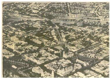
... AERIAL VIEW OF BENDIGO......Aerial view of bendigo...Photograph AERIAL VIEW OF BENDIGO ...Black and white photo: view of Bendigo with Mitchell St. from centre left to centre. Shows Sacred Heart Cathedral at left. Coles supermarket carpark in foreground. Dome of RSL in Pall Mall in front of trees to right. On back C 26A. Noelene Wild July 2000 ' photo by Peter Hyett 1995 from St. Paul's Myer St., Sacred Heart Cathedral at left.'Peter Hyettplace, aerial view of bendigo -
 Bendigo Historical Society Inc.
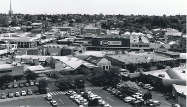
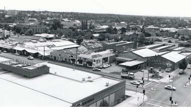
Photograph - AERIAL VIEW OF BENDIGO, 1995
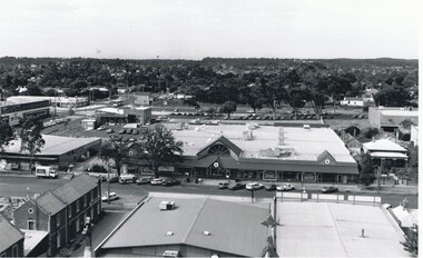
... AERIAL VIEW OF BENDIGO......Aerial view of bendigo...On back 'C27A' Photograph AERIAL VIEW OF BENDIGO ...Black and white photo. View from St. Paul's, tower showing Coles New World, Furniture Warehouse, Webbs Flour Mill, Library, Town Hall, Shamrock Hotel, Multistorey car park. On back 'C27A'Peter Hyettplace, aerial view of bendigo -
 Bendigo Historical Society Inc.
Photograph - WES HARRY COLLECTION: AERIAL VIEW OF BENDIGO CBD, 1966
... WES HARRY COLLECTION: AERIAL VIEW OF BENDIGO CBD......Aerial view of bendigo...PLACE Aerial view of bendigo cbd Bendigo CBD Aerial Survey of Victoria Aerial photograph of the Bendigo CBD. ...Aerial photograph of the Bendigo CBD. On the reverse is written : 'City of Bendigo 1966, State aerial Surveyplace, aerial view of bendigo, cbd, bendigo cbd, aerial survey of victoria -
 Bendigo Historical Society Inc.
Photograph - FORTUNA COLLECTION: AERIAL VIEW OF BENDIGO 1963
... FORTUNA COLLECTION: AERIAL VIEW OF BENDIGO 1963...Black and white photograph, aerial view of Bendigo 1963, Fortuna Villa in foreground. ...History House 11 Mackenzie Street Bendigo goldfields Black and white photograph, aerial view of Bendigo 1963, Fortuna Villa in foreground. ...Black and white photograph, aerial view of Bendigo 1963, Fortuna Villa in foreground. On bottom of photograph ' Fortuna, an aerial view of Bendigo Circa 1963' Fortuna Villa in foregound of image, showing very clear detail of grounds. Image has labels of following sites: Lansell's 222 mine Lazarus mine site Central Red, White and Bluye mine site, Old Chum mine site New Chum and Victoria mine site West End Hall Mount Alvernia BCV8 QEO -
 Bendigo Historical Society Inc.
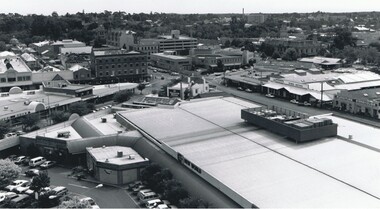
Photograph - AERIAL VIEW OF BENDIGO, 1995
... AERIAL VIEW OF BENDIGO...Mitchell St. runs across photo - intersection with Edwards St. on left '; Photograph AERIAL VIEW OF BENDIGO ...Black and white photograph taken from St. Paul's, Mitchell runs from left corner. Cathedral spire in centre. T.V. towers in background. Central Deborah poppet head far left ? Ian Wild 7.2000 ' photo - Peter Hyett 1995 - ? From St. Paul's. Mitchell St. runs across photo - intersection with Edwards St. on left ';Peter Hyettcottage, miners -
 Bendigo Historical Society Inc.
Photograph - AERIAL VIEW: BENDIGO, Approx. 1935
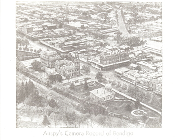
... AERIAL VIEW: BENDIGO......Aerial view of bendigo...black and white photo ( from newspaper /): aerial view of Bendigo City Centre, Post Office and Shamrock Hotel. ...Photograph AERIAL VIEW: BENDIGO ...BHS Collectionblack and white photo ( from newspaper /): aerial view of Bendigo City Centre, Post Office and Shamrock Hotel. Rosalind Park in foreground, looking north east.Airspy ?place, aerial view of bendigo -
 Bendigo Historical Society Inc.
Photograph - HANRO COLLECTION: AERIAL VIEW OF HANRO BENDIGO
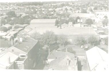
... HANRO COLLECTION: AERIAL VIEW OF HANRO BENDIGO...Black and White aerial view photograph of the Hanro Knitting Mills, Hargreaves Street, Bendigo, in the centre of the photo....Photograph HANRO COLLECTION: AERIAL VIEW OF HANRO BENDIGO ...Photograph. Black and White aerial view photograph of the Hanro Knitting Mills, Hargreaves Street, Bendigo, in the centre of the photo.organization, business, hanro knitting mills, hanro -
 Bendigo Historical Society Inc.
Photograph - BENDIGO RAILWAY STATION: AERIAL VIEW, 1995
... BENDIGO RAILWAY STATION: AERIAL VIEW......Aerial view of bendigo...Black and white photo: aerial view looking trowards Bendigo Railway Station. Mitchell st. runs across lower part of photo. ...History House 11 Mackenzie Street Bendigo goldfields PLACE Aerial view of bendigo bendigo railway station Peter Hyett 1995 Black and white photo: aerial view looking trowards Bendigo Railway Station. ...Black and white photo: aerial view looking trowards Bendigo Railway Station. Mitchell st. runs across lower part of photo. Photo taken prior to building of 'Market place' shopping centre. A 16A black lead on rear.Peter Hyett 1995place, aerial view of bendigo, bendigo railway station -
 Bendigo Historical Society Inc.
Photograph - BENDIGO - PANORAMA FROM FIRE TOWER
... ...Aerial view of bendigo...History House 11 Mackenzie Street Bendigo goldfields PLACE Aerial view of bendigo fire tower. BENDIGO. PANORAMA FROM FIRE TOWER. ...Photograph - sepia. Photograph panorama from Fire Tower, Bendigo.. In the distance shops that I can read 'Mobiloils', 'Cockings', 'Cocks Motor Garage', back view of the Conservatory building and gardens. The Rose Series P.3231. It is written on back but unable to read much, its from Monica. Trees etc along the bottom front are part the rosalind park.Rose Seriesplace, aerial view of bendigo, fire tower., bendigo. panorama from fire tower. -
 Bendigo Historical Society Inc.
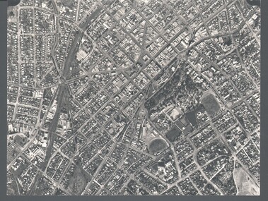
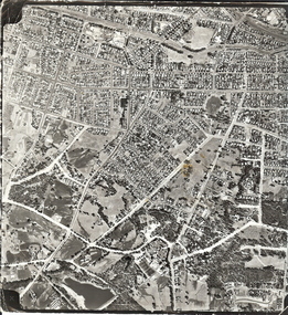
Photograph - AERIAL SURVEY BENDIGO BASE MAP - RUN 12
... ...Aerial view of bendigo...History House 11 Mackenzie Street Bendigo goldfields PLACE Aerial view of bendigo Black and white photograph which is an aerial survey Bendigo base map - run 12. ...Black and white photograph which is an aerial survey Bendigo base map - run 12. Inscriptions: Vic 1583. State Aerial Survey Bendigo Base Map Project - Run 12. 16/3/1967, 5600ASL on front. The photograph shows areas of Kennington and Flora Hill. Title of map to be held at right hand side. Streets identifiable from 'Five Ways' intersection.place, aerial view of bendigo -
 Bendigo Historical Society Inc.
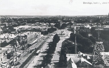
Photograph - PALL MALL: HUSTLER'S ROYAL RESERVE MINE, early 1900
... ...Aerial view of bendigo...History House 11 Mackenzie Street Bendigo goldfields PLACE Aerial view of bendigo pall mall Valentine ? Black and white photo . ...Black and white photo . View of Pall Mall and Hustler's Royal Reserve Mine, Bendigo, looking west. James Lerk ( 5/11/1999 ) 'View from the public offices tower, Hustler's Royal Reserve Mine, from the post office tower 'Valentine ?place, aerial view of bendigo, pall mall -
 Bendigo Historical Society Inc.
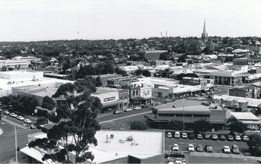
Photograph - AERIAL VIEW BENDIGO, 1995
... AERIAL VIEW BENDIGO......Aerial view of bendigo...Photograph AERIAL VIEW BENDIGO ...Black and white photo: aerial view Mollison St., Jewel Shopping complex ( Noelene Wild 7/2000 ) from St. Paul's tower ? Mollison St. left to right foreground. 'B22A' black lead on rear.Peter Hyettplace, aerial view of bendigo -
 Bendigo Historical Society Inc.
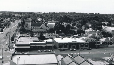
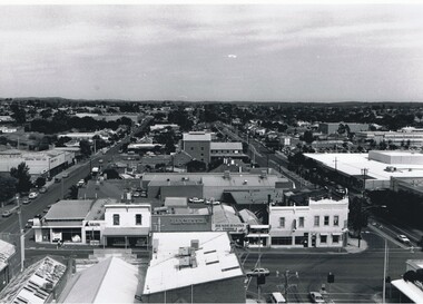
Photograph - AERIAL VIEW: BENDIGO, 1995
... AERIAL VIEW: BENDIGO......Aerial view of bendigo...Photograph AERIAL VIEW: BENDIGO ...Black and white photo: aerial view from St. Paul's church tower showing Bush's store in foreground. St. Andrew's church middle distance, Myers St. at left front to middle distance. Williamson St. left to right foreground.Peter Hyettplace, aerial view of bendigo -
 Bendigo Historical Society Inc.
Photograph - AERIAL VIEW BENDIGO, 1995
... AERIAL VIEW BENDIGO......Aerial view of bendigo...History House 11 Mackenzie Street Bendigo goldfields PLACE Aerial view of bendigo Peter Hyett Black and white photo: Bendigo skyline from St. ...Black and white photo: Bendigo skyline from St. Pauls, bottom left corner of Williamson St. and Myers St., Williamson St. across centre of photo. Anne Caudle centre left on skyline. Bendigo Base Hospital centre on skyline. ( Noelene Wild - 7.2000 ) In image ' Bruce's Discount Store ' ' Nissan Symes Motors ' ' Furniture Warehouse' Bendigo Bulk Carpets' The Carpet Giants 'Peter Hyettplace, aerial view of bendigo -
 Bendigo Historical Society Inc.
Photograph - AERIAL VIEW BENDIGO, 1995
... AERIAL VIEW BENDIGO......Aerial view of bendigo...History House 11 Mackenzie Street Bendigo goldfields PLACE Aerial view of bendigo Peter Hyett Black and white photograph: city skyline taken from St. ...Black and white photograph: city skyline taken from St. Pauls's, Mitchell St. in foreground ( left to right ) Wills St. on RHS ( to distance ) and Garsed St. on LHS ( to distance ) Edwards St. ( next street parallel to Mitchell St. ( Noelene Wild 7.2000 )Peter Hyettplace, aerial view of bendigo -
 Bendigo Historical Society Inc.
Map - BENDIGO MAP AERIAL VIEW
... BENDIGO MAP AERIAL VIEW...Map of Bendigo. Aerial View of Bendigo. Published by City of Bendigo. ...History House 11 Mackenzie Street Bendigo goldfields PHOTOGRAPH Aerial bendigo Map of Bendigo. Aerial View of Bendigo. Published by City of Bendigo. ...Map of Bendigo. Aerial View of Bendigo. Published by City of Bendigo. Undated.photograph, aerial, bendigo -
 Bendigo Historical Society Inc.
Map - BENDIGO MAP AERIAL VIEW, 1934
... BENDIGO MAP AERIAL VIEW...Map of Bendigo. Aerial View of Bendigo taken in 1934. Published by City of Great Bendigo....History House 11 Mackenzie Street Bendigo goldfields PHOTOGRAPH Aerial bendigo 1934 Map of Bendigo. Aerial View of Bendigo taken in 1934. ...Map of Bendigo. Aerial View of Bendigo taken in 1934. Published by City of Great Bendigo.photograph, aerial, bendigo 1934 -
 Bendigo Historical Society Inc.
Map - BENDIGO MAP AERIAL VIEW, 1890s
... BENDIGO MAP AERIAL VIEW...Map of Bendigo. Aerial View of Bendigo. This aerial photograph was taken specially to mark the pccasion of the United Country party conference of 1936. ...History House 11 Mackenzie Street Bendigo goldfields PHOTOGRAPH Aerial bendigo Map of Bendigo. Aerial View of Bendigo. This aerial photograph was taken specially to mark the pccasion of the United Country party conference of 1936. ...Map of Bendigo. Aerial View of Bendigo. This aerial photograph was taken specially to mark the pccasion of the United Country party conference of 1936. Issued with the complements of 'The Argus' April 1936.photograph, aerial, bendigo -
 Ballarat Tramway Museum
Photograph - Black & White Photograph/s, early 1960's
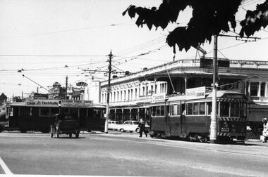
... Black and White print of an aerial view of Bendigo SECV Bendigo tram 18 at Charing Cross terminus for the Eaglehawk route with another bogie tram and two single truck trams in the background. ...Ballarat Tramway Museum South Gardens Reserve Wendouree Parade Ballarat Ballarat goldfields trams tramways Charing Cross Bendigo Mitchell St Aerial views tram 18 Black and White print of an aerial view of Bendigo SECV Bendigo tram 18 at Charing Cross terminus for the Eaglehawk route with another bogie tram and two single truck trams in the background. ...Black and White print of an aerial view of Bendigo SECV Bendigo tram 18 at Charing Cross terminus for the Eaglehawk route with another bogie tram and two single truck trams in the background. Trams have dash canopy lights, but no large white strip under the drivers windows. Photo not dated but appears to be at during early 1960's. Tram 18 has White Horse Whiskey ad on front dash panel, SEC Roof ads. Numbers of other trams cannot be determined. All trams have roof ads, including SEC ads and a CASTROL ad. Good view of the fountain and buildings on the north east corner. Has Ezywalkin store, City Club Hotel and other buildings. Shows traffic arrangements for cars to do a right turn from Pall Mall into Mitchell St. On a building in Mitchell St. is an advertisement for "ASTOR Radio"trams, tramways, charing cross, bendigo, mitchell st, aerial views, tram 18 -
 Bendigo Historical Society Inc.
Ephemera - Vintage Calendar of Bendigo. 2016
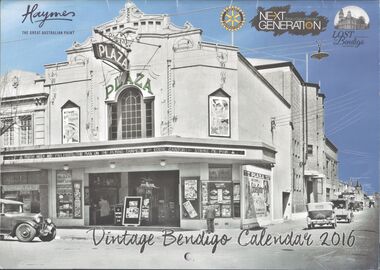
... January: Pall Mall, 1870's; February, Bendigo Mall, opened in 1981; March, aerial view of Bendigo Goal and Camp Hill, 1922; April, Easter Monday, Howard Place, 1903; May, 'Aldo's Auto Repairs', St. ...January: Pall Mall, 1870's; February, Bendigo Mall, opened in 1981; March, aerial view of Bendigo Goal and Camp Hill, 1922; April, Easter Monday, Howard Place, 1903; May, 'Aldo's Auto Repairs', St. ...2016 Vintage Bendigo calendar. 12-month calendar. One historic image of Bendigo per month. January: Pall Mall, 1870's; February, Bendigo Mall, opened in 1981; March, aerial view of Bendigo Goal and Camp Hill, 1922; April, Easter Monday, Howard Place, 1903; May, 'Aldo's Auto Repairs', St. Andrews Avenue; June, Charing Cross, 1920's; July, Bendigo Municipal pool; August, Ordinance Factory, Shop Number 9, 1940's; September, Gillies corner, 1960's; October, Jim Elvey's View Point Hotel at Charing Cross; 1960's; November, Mitchell Street, 1950's; December, Pall Mall, 1940's. This calendar has not been used, and has no personal notations made on it. At the back are a list of Public Holidays for each state and territory, and a list of sponsors/advertisers, including Haymes, Rotary Club and Lost Bendigo.bendigo, business, calendar -
 Bendigo Historical Society Inc.
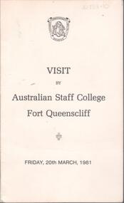
Programme - Australian Defence Industries (ADI) - Program for visit by Australian Staff College Fort Queenscliff, Friday 20th March 1981
... Bifold introduction to the facilities at Ordinance Factory, Bendigo; with B&W aerial view of Ordinance Factory, Bendigo on back cover of the program....Bifold introduction to the facilities at Ordinance Factory, Bendigo; with B&W aerial view of Ordinance Factory, Bendigo on back cover of the program. ...Australian Defence Industries (ADI) - Program for visit by Australian Staff College Fort Queenscliff, Friday 20th March 198. Bifold introduction to the facilities at Ordinance Factory, Bendigo; with B&W aerial view of Ordinance Factory, Bendigo on back cover of the program.adi history, visitor introduction/program -
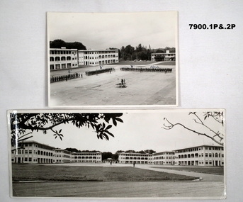 Bendigo Military Museum
Photograph - SELARANG BARRACKS, 1970
... Bendigo Military Museum 37 - 39 Pall Mall Bendigo goldfields Various photos of Selarang Barracks in Singapore in 1970. Some aerial and some ground level views. ...Various photos of Selarang Barracks in Singapore in 1970. Some aerial and some ground level views. Refer items in Collection of LLoyd Farrell. Refer Cat 7889P.1. Photo of 1 RAR on parade for Trooping of the Colours in 1970 at Selarang Base in Singapore. Covering 'A' 'B' 'C' and Admin Company. 2. Extended portrait photo of the Parade Square and buildings of Selarang Base, Singapore in 1970. 3. Aerial photo of Selarang Barracks from a distance. 4. Aerial photo of Selarang Barracks 1970. 5. Aerial photo of Changi Prison 1970 in Singapore.Written on back. 1. "1 M1+" 2. “Selarang Barracks 1970 occupied by 1st RAR” 4. “Selarang 70” 5. "Changi Prison 1970 Singapore".photograhs, changi, selarang, 1970, lloyd farrell. -
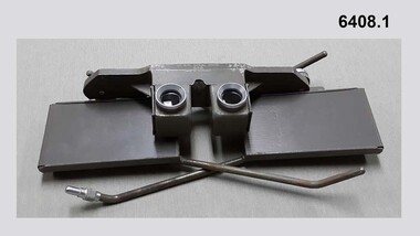 Bendigo Military Museum
Instrument - Universal Stereoscope, 1940
... Bendigo Military Museum 37 - 39 Pall Mall Bendigo goldfields The Universal Stereoscope was used to view overlapping stereo aerial photography in three dimensions (3D). ...The Universal Stereoscope was used to view overlapping stereo aerial photography in three dimensions (3D). It consists of magnifying lenses, an optical train including glass prisms and mirrors that are protected by sliding metal covers all suspended on a pair of fold out adjustable legs. The stereoscope is coloured military olive drab green. This Universal Stereoscope was produced in Australia in 1940 for Military use. It was originally produced with a timber protecting carry box that is missing. It was used extensively by members of the Australian Survey Corps during WWII in many theatres of War for viewing and annotating aerial photography. Item 6205.6P, photograph 6205.1P shows the Universal Stereoscope in use by the Australian Survey Corps annotating aerial photography.The Universal Stereoscope was used to view overlapping stereo aerial photography in three dimensions (3D). It consists of magnifying lenses, an optical train including glass prisms and mirrors that are protected by sliding metal covers all suspended on a pair of fold out adjustable legs. The stereoscope is coloured military olive drab green."DC-1940 Serial No 550", "D V D", "Made in Australia" Plate on the underside reads " This stereoscope was donated to the Ex Fortuna Survey Association by the Eaglehawk Recycle Shop February 2015"royal australian survey corps, rasvy, fortuna, army survey regiment, army svy regt, asr -
 Bendigo Military Museum
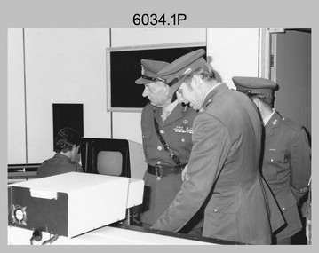
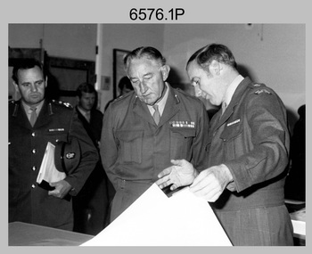
Photograph - Visit by the Chief of the General Staff to the Army Survey Regiment, Fortuna, Bendigo, 1979
... Bendigo on the 5th of June 1979. The photographs were printed on photographic paper and are part of the Army Survey Regiment’s Collection. They were scanned at 300 dpi. .1) - Photo, black and white, 1979. Tour of Air Survey Squadron. L to R: unidentified, LTGEN General Sir Donald Dunstan AC, KBE, CB; OC MAJ Peter Eddy, unidentified. .2) - Photo, black and white, 1979. Tour of Air Survey Squadron. LTGEN General Sir Donald Dunstan AC, KBE, CB; views 3D stereoscopic aerial...Bendigo on the 5th of June 1979. The photographs were printed on photographic paper and are part of the Army Survey Regiment’s Collection. They were scanned at 300 dpi. .1) - Photo, black and white, 1979. Tour of Air Survey Squadron. L to R: unidentified, LTGEN General Sir Donald Dunstan AC, KBE, CB; OC MAJ Peter Eddy, unidentified. .2) - Photo, black and white, 1979. Tour of Air Survey Squadron. LTGEN General Sir Donald Dunstan AC, KBE, CB; views 3D stereoscopic aerial ...This is a set of 14 photographs of a visit to the Army Survey Regiment, Fortuna, Bendigo on the 5th of June 1979 by the Chief of the General Staff (CGS) Lieutenant General Sir Donald Dunstan AC, KBE, CB. He was accompanied by his wife. They were escorted through the production areas of the Army Survey Regiment by the CO LTCOL Bob Skitch. Lieutenant General Sir Donald Dunstan AC, KBE, CB was an esteemed Australian Army officer, who was CGS from 1977 to 1982. Upon retirement from the Army in 1982, he was appointed to the position of Governor of South Australia from 1982 to 1991. LTCOL Bob Skitch was the CO of the Army Svy Rgt from 1976 to 1980. Also featuring in these photos is MAJ Peter Eddy, who was the OC of Air Survey Squadron. He was later promoted to LTCOL and was CO of the Army Svy Rgt from 1981 to 1982. See item 6035.9P for photos of the CGS’s presentation of the Defence Force Service Medal to four recipients.This is a set of 14 photographs of a visit by the Chief of the General Staff to the Army Survey Regiment Fortuna, Bendigo on the 5th of June 1979. The photographs were printed on photographic paper and are part of the Army Survey Regiment’s Collection. They were scanned at 300 dpi. .1) - Photo, black and white, 1979. Tour of Air Survey Squadron. L to R: unidentified, LTGEN General Sir Donald Dunstan AC, KBE, CB; OC MAJ Peter Eddy, unidentified. .2) - Photo, black and white, 1979. Tour of Air Survey Squadron. LTGEN General Sir Donald Dunstan AC, KBE, CB; views 3D stereoscopic aerial photography on a Zeiss (Jena) Stecometer. OC MAJ Peter Eddy is on his right. .3) - Photo, black and white, 1979. Tour of Air Survey Squadron. L to R: unidentified, CO LTCOL Bob Skitch, OC MAJ Peter Eddy, LTGEN General Sir Donald Dunstan AC, KBE CB viewing an aerial photograph. WO1 Brian Mead and others are operating a Wild PUG4 point transfer device. .4) - Photo, black and white, 1979. Enlargement of photo .3). Tour of Air Survey Squadron. L to R: unidentified, CO LTCOL Bob Skitch, OC MAJ Peter Eddy, LTGEN General Sir Donald Dunstan AC, KBE CB viewing an aerial photograph. .5) - Photo, black and white, 1979. Tour of Air Survey Squadron. LTGEN General Sir Donald Dunstan AC, KBE, CB; and unidentified technician view 3D stereoscopic aerial photography on a Wild B8 stereo plotter. .6) - Photo, black and white, 1979. Tour of Air Survey Squadron. L to R: OC MAJ Peter Eddy LTGEN General Sir Donald Dunstan AC, KBE CB; CO LTCOL Bob Skitch, view the output of a verification plot on an AUTOMAP 1 Gerber 1442 drum plotter. .7) - Photo, black and white, 1979. Tour of Air Survey Squadron. L to R: CO LTCOL Bob Skitch, unidentified aide de camp officer, LTGEN General Sir Donald Dunstan AC, KBE CB; OC MAJ Peter Eddy discuss aero triangulation planning documents. CAPT Don Maskew in background. .8) - Photo, black and white, 1979. Tour of Cartographic Squadron. L to R: CPL Dennis Learmonth, acting OC CAPT Bob Roche, CAPT Eddy Schulze, LTGEN General Sir Donald Dunstan AC, KBE CB; SSGT John ‘JB’ Barrie discuss cartographic map compilation procedures .9) - Photo, black and white, 1979. Tour of Cartographic Squadron. L to R: Tech WO WO1 Roger Rix, acting OC CAPT Bob Roche, CAPT Eddy Schulze, unidentified visitor, Mrs Dunstan with examples of map products. .10) - Photo, black and white, 1979. Tour of Cartographic Squadron. L to R: CPL Terry Danger, CO LTCOL Bob Skitch, LTGEN General Sir Donald Dunstan AC, KBE CB; discuss terrain embossing (hill shading) procedures. .11) - Photo, black and white, 1979. Tour of Cartographic Squadron. L to R: CO LTCOL Bob Skitch, LTGEN General Sir Donald Dunstan AC, KBE CB; acting OC CAPT Bob Roche, SSGT Dick Manley, CAPT Don Maskew and CAPT Steve Cooper in background. SPR Cheryl Lofthouse is retouching blemishes on a map separation film negative. .12) - Photo, black and white, 1979. Tour of Lithographic Squadron. L to R: CAPT Stan Vote, unidentified aide de camp officer, CO LTCOL Bob Skitch, LTGEN General Sir Donald Dunstan AC, KBE CB; MAJ Sam Schwartz EXCH-US, LT John Harrison discuss bulk map printing processes with an Ultra-MAN-III Printing Press. .13) - Photo, black and white, 1979. Officers Mess L to R: LTGEN General Sir Donald Dunstan AC, KBE CB; with CO LTCOL Bob Skitch. .14) - Photo, black and white, 1979. Officers Mess L to R: MAJ Peter Eddy, LTGEN General Sir Donald Dunstan AC, KBE CB..1P to .14P – no annotationsroyal australian survey corps, rasvy, army survey regiment, army svy regt, fortuna, asr -
 Bendigo Military Museum
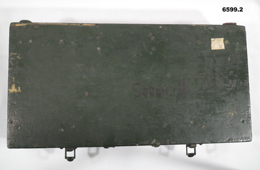
Instrument - Universal Stereoscope - boxed, 1940
... Bendigo Military Museum 37 - 39 Pall Mall Bendigo goldfields The Universal Stereoscope was used to view overlapping stereo aerial photography in three dimensions (3D). ...The Universal Stereoscope was used to view overlapping stereo aerial photography in three dimensions (3D). It consists of magnifying lenses, an optical train including glass prisms and mirrors that are protected by sliding metal covers, all suspended on a pair of fold out adjustable legs. The Universal Stereoscope was produced in Australia in 1940 for military use and has its protective wooden box. It was used extensively by members of the Australian Army Survey Corps during WWII in many theatres of war for viewing and annotating aerial photography. See also photograph at 6205.6P. 6205.1P shows the Universal Stereoscope in use by Royal Australian Survey Corps annotating Aerial Photography.6599.1 Wooden Box that contains a Universal Stereoscope. 6599.2 Open Wooden Box showing a folded Universal Stereoscope. A dark green wooden box containing a Universal Stereoscope with spare mirrors. The Universal Stereoscope was used to view overlapping stereo aerial photography in three dimensions (3D). It consists of magnifying lenses, an optical train including glass prisms and mirrors that are protected by sliding metal covers, all suspended on a pair of fold out adjustable legs. The stereoscope is painted a dark green colour."DC 1940" "Serial (Number) - 239 D>D"royal australian survey corps, rasvy, fortuna, army survey regiment, army svy regt -
 Bendigo Military Museum
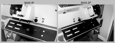
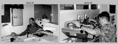
Photograph - Aerotriangulation Production – Army Survey Regiment, Fortuna, Bendigo, c1989
... view the photography containing the survey control points and the mapping aerial photography. The Control points were transferred from the control photography to the mapping diapositives of aerial photography by drilling their locations into the photographic emulsion. See item 6195.19P for more photos of aerotriangulation equipment and their operation in map production. Royal Australian Survey Corps RASvy Fortuna Army Survey Regiment air survey aerotrig .1P to .17P – There are no annotations This is a set of 17 photographs of Air Survey Squadron aerotriangulation equipment and personnel taken at the Army Survey Regiment at Fortuna, Bendigo ...This collection of 17 photographs of Air Survey Squadron aerotriangulation equipment and personnel was taken at the Army Survey Regiment, Fortuna, Bendigo, circa 1989. The PDP 11/70 minicomputer was the operating system introduced in 1977 as the mainframe system for the control of the APC4, aerial triangulation block adjustments, SORA OP Analytical Orthophoto control, APR Analytical Terrain Profile Recorder computation, graphics, and general computing. The OMI/Nistri AP/C-3 analytical plotter shown in photo .1P to .6P and .9P was introduced in 1972–1973. The Zeiss (Jena) Stecometer analytic stereocomparator for air photography shown in photo .16P was introduced at Air Survey Squadron in 1963. Aerotriangulation production was expedited using computers for analytical photogrammetric processes. The technician accurately measured between pass, tie, and survey control points on aerial photographs. Wild PUG4 point transfer devices as shown in photo .17P, were introduced in c1968 superseding the PUG2 devices. PUG4 devices were used by technicians to stereoscopically view the photography containing the survey control points and the mapping aerial photography. The Control points were transferred from the control photography to the mapping diapositives of aerial photography by drilling their locations into the photographic emulsion. See item 6195.19P for more photos of aerotriangulation equipment and their operation in map production.This is a set of 17 photographs of Air Survey Squadron aerotriangulation equipment and personnel taken at the Army Survey Regiment at Fortuna, Bendigo, circa 1989. The photographs are on 35mm negative film and scanned at 96 dpi. They are part of the Army Survey Regiment’s Collection. .1) to .7) - Photo, black & white, c1989, OMI/Nistri APC/3-1 analytical stereoplotter. .8) - Photo, black & white, c1989, miscellaneous aerotriangulation equipment. .9) to.10) - Photo, black & white, c1989, Digital Equipment Corporation (DEC) 11 VO3-L Superminicomputer, with VT52 DECScope terminal. .11) to .15) - Photo, black & white, c1989, miscellaneous aerotriangulation equipment. .16) - Photo, colour, c1989, Zeiss (Jena) Stecometer, unidentified technician. .17) - Photo, black & white, c1989, Wild PUG4 point transfer device, unidentified technician..1P to .17P – There are no annotationsroyal australian survey corps, rasvy, fortuna, army survey regiment, air survey, aerotrig -
 Bendigo Military Museum
Photograph - Visit by MAJGEN David Engel AO OBE, to the Army Survey Regiment, Fortuna, Bendigo, 1982
... Bendigo by the Deputy Chief of the General Staff - Major General David Frederick Walter Engel AO, OBE on the 30th of August 1982. The black and white photograph was printed on photographic paper and are part of the Army Survey Regiment’s Collection. The photographic print was scanned at 300 dpi. .1) - Photo, black & white, 1982. Map production brief - L to R: unidentified Brigadier, unidentified visitor in background, MAJGEN David Engel AO OBE, CO LTCOL Peter Eddy. .2) - Photo, black & white, 1982. MAJGEN David Engel AO OBE views stereo aerial...Bendigo by the Deputy Chief of the General Staff - Major General David Frederick Walter Engel AO, OBE on the 30th of August 1982. The black and white photograph was printed on photographic paper and are part of the Army Survey Regiment’s Collection. The photographic print was scanned at 300 dpi. .1) - Photo, black & white, 1982. Map production brief - L to R: unidentified Brigadier, unidentified visitor in background, MAJGEN David Engel AO OBE, CO LTCOL Peter Eddy. .2) - Photo, black & white, 1982. MAJGEN David Engel AO OBE views stereo aerial ...This set of three photographs was taken the 30th of August 1982 during a visit to the Army Survey Regiment, Bendigo by the Deputy Chief of the General Staff - Major General David Frederick Walter Engel AO, OBE. As there are no annotations on the photo, the name of the Brigadier is unknown. LTCOL Peter Eddy was the CO of the Army Survey Regiment from 1981 to 1992 and handed over to LTCOL Jorge Gruszka, who commanded the unit from 1982 to 1985.This is set of three photographs taken on the occasion of a visit to the Army Survey Regiment, Bendigo by the Deputy Chief of the General Staff - Major General David Frederick Walter Engel AO, OBE on the 30th of August 1982. The black and white photograph was printed on photographic paper and are part of the Army Survey Regiment’s Collection. The photographic print was scanned at 300 dpi. .1) - Photo, black & white, 1982. Map production brief - L to R: unidentified Brigadier, unidentified visitor in background, MAJGEN David Engel AO OBE, CO LTCOL Peter Eddy. .2) - Photo, black & white, 1982. MAJGEN David Engel AO OBE views stereo aerial photography on a Wild B8 stereo plotter. .3) - Photo, black & white, 1982. Aerial photography brief - L to R: MAJGEN David Engel AO OBE, CO LTCOL Peter Eddy..1P to .3P –No personnel are identified. ‘Visit to ASR by MAJGEN Engel 30 Aug 1982’ annotated on cover sleeve.royal australian survey corps, rasvy, army survey regiment, army svy regt, fortuna -
 Bendigo Military Museum
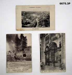
Postcard - POSTCARDS WW1, PHOTOGRAPHIC, C.1914 - 1918
... Bendigo goldfields Postcard photos of locations in Northern France relating to Battlefields in WW1. Passchendaele Barracks Trust Postcards France WW1 1. Headed "Hazebrouck - Vue Generale" - on back is filled in Letter to "Louie". 2. Titled Campagne De 1914-15 - Ruines D' Ypres - Fire of Belfrey. 3. Titled "Rouen - Grille De I'Eglise Saint-Oven (Gate of St Oven Church). 1. B & W photo of aerial view ...Postcard photos of locations in Northern France relating to Battlefields in WW1.1. B & W photo of aerial view town of Hazebrouck at time of WW1. 2. B & W photo of ruins of Cathedral in Ypres from WW1 called "Fire of the Belfrey". 3. B & W photo of the gate of Saint Oven Church in Rouen Church.1. Headed "Hazebrouck - Vue Generale" - on back is filled in Letter to "Louie". 2. Titled Campagne De 1914-15 - Ruines D' Ypres - Fire of Belfrey. 3. Titled "Rouen - Grille De I'Eglise Saint-Oven (Gate of St Oven Church).passchendaele barracks trust, postcards, france, ww1 -
 Bendigo Military Museum
Photograph - Aerotriangulation Production – Army Survey Regiment, Fortuna, Bendigo, c1993
... Bendigo, c1993. PUG4 devices were used by technicians to stereoscopically view the photography containing the survey control points and the mapping aerial photography. ...Bendigo, c1993. PUG4 devices were used by technicians to stereoscopically view the photography containing the survey control points and the mapping aerial photography. ...This is a collection of eight photographs of Air Survey Squadron personnel operating aerotriangulation equipment at the Army Survey Regiment at Fortuna, Bendigo, c1993. PUG4 devices were used by technicians to stereoscopically view the photography containing the survey control points and the mapping aerial photography. The Control points were transferred from the control photography to the mapping diapositives of aerial photography by drilling their locations into the photographic emulsion. The Zeiss (Jena) Stecometer analytic stereocomparator for air photography shown in photo .1P was introduced at Air Survey Squadron in 1963. Wild PUG4 point transfer devices shown in photos .2P to .4P were introduced in c1968 superseding the PUG2 devices. See item 6195.19P for more photos and descriptions of Air Survey Squadron personnel and aerotriangulation equipment.This is a set of eight photographs of Air Survey Squadron personnel operating aerotriangulation equipment at the Army Survey Regiment at Fortuna, Bendigo, c1993. The photographs were on 35mm negative film and were scanned at 96 dpi. They are part of the Army Survey Regiment’s Collection. .1) - Photo, black & white, c1993, Zeiss (Jena) Stecometer, SPR Kim Baker. .2) - Photo, black & white, c1993, Wild PUG4 point transfer device, CPL Paul Bouton. .3) to .4) - Photo, black & white, c1993, Wild PUG4 point transfer device, L to R: CPL Darren Scott, CPL Paul Bouton. .5) to .6P) - Photo, black & white, c1993, CPL Doug Willis. .7) - Photo, black & white, c1993, WO2 Noel ‘Macca’ McNamara. .8) - Photo, black & white, c1993, SGT Barry Miller..1P to .8P - There are no annotations.royal australian survey corps, rasvy, army survey regiment, army svy regt, fortuna, asr, aerotrig -
 Bendigo Military Museum
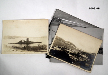
Photograph - PHOTOGRAPHS, BCOF, 1946 - 47
... Bendigo Military Museum 37 - 39 Pall Mall Bendigo goldfields Items in the collection re Clarence Shearing, refer Cat No 7089.16P for his service details. Photographs BCOF 130th Naval "A torpedoed Ship at Kojo Ferry Eta Jima" "An aerial view of the former Naval Academy - now HQ BCOF area - The building with the X is where I work" Photographs B & W some are copies. ...Items in the collection re Clarence Shearing, refer Cat No 7089.16P for his service details.Photographs B & W some are copies. Two are of the 130th Australian General Hospital, BCOF HQ. One of a torpedoed ship. Aerial view of the Japanese Naval Academy. Four showing different views of the Naval Academy."A torpedoed Ship at Kojo Ferry Eta Jima" "An aerial view of the former Naval Academy - now HQ BCOF area - The building with the X is where I work"photographs, bcof, 130th, naval