Showing 891 items matching "aerial views"
-
 Glenelg Shire Council Cultural Collection
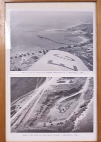
Photograph - Photographs - Aerial views of Portland and Cape Grant Quarry, 1957
... Photographs - Aerial views of Portland and Cape Grant Quarry...Two photographs of aerial views in a wooden varnished frame....Front: Aerial view of Portland Harbour construction - Christmas 1957. ...(typed, under lower image) Two photographs of aerial views in a wooden varnished frame. Photograph Photographs - Aerial views of Portland and Cape Grant Quarry ...Displayed in History House.Two photographs of aerial views in a wooden varnished frame.Front: Aerial view of Portland Harbour construction - Christmas 1957. (typed, under top image) Back: Bird's eye view of Cape Grant quarry - Christmas, 1957. (typed, under lower image)aerial photography, cape grant, portland harbour -
 Federation University Historical Collection
Photographs - black and white, Ballarat College of Advanced Education, Aerial views of the Mt Helen campus from the north, not dated
... Ballarat College of Advanced Education, Aerial views of the Mt Helen campus from the north ...2 black and white aerial photographs .1) Aerial view of Mt Helen campus from the north .2) Aerial view from the north...mount helen campus mount helen campus aerial student residences 2 black and white aerial photographs .1) Aerial view of Mt Helen campus from the north .2) Aerial view from the north Ballarat College of Advanced Education, Aerial views of the Mt Helen campus from the north Photographs - black and white ...2 black and white aerial photographs .1) Aerial view of Mt Helen campus from the north .2) Aerial view from the northmount helen campus, mount helen campus aerial, student residences -
 Federation University Historical Collection
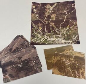
Photograph, Aerial Views of Mount Helen Campus, late 1988
... Aerial Views of Mount Helen Campus...Four aerial views of Mount Helen Campus...Barker Library (top floor) Mount Helen goldfields mount helen campus buildings aerial Four aerial views of Mount Helen Campus Aerial Views of Mount Helen Campus Photograph ...Four aerial views of Mount Helen Campusmount helen campus, buildings, aerial -
 Federation University Historical Collection
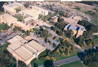
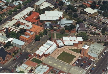
Photograph - Photograph - Colour, Aerial Views of Sites Relating to the University of Ballarat, c1998
... Aerial Views of Sites Relating to the University of Ballarat.......ballarat aerial view...Five colour aerial photographs of sites associated with Federation University Australia. .1 & .2) Aerial views of the State Data Centre, Ballarat Technology Park .3) Aerial view of Mt Helen Campus, c1990 .4 and .5) Aerial View of Ballarat School of Mines Campus, 1998...Barker Library (top floor) Mount Helen goldfields The Ballarat Technology Park is associated with Federation University Australia. ballarat technology park state region data centre ballarat aerial view ballarat school of mines aerial aerial brewery building ballarat uniting church albert street Five colour aerial photographs of sites associated with Federation University Australia. .1 & .2) Aerial views of the State Data Centre, Ballarat Technology Park .3) Aerial view of Mt Helen Campus, c1990 .4 and .5) Aerial View of Ballarat School of Mines Campus, 1998 Aerial Views of Sites Relating to the University of Ballarat. ...The Ballarat Technology Park is associated with Federation University Australia. Five colour aerial photographs of sites associated with Federation University Australia. .1 & .2) Aerial views of the State Data Centre, Ballarat Technology Park .3) Aerial view of Mt Helen Campus, c1990 .4 and .5) Aerial View of Ballarat School of Mines Campus, 1998ballarat technology park, state region data centre, ballarat aerial view, ballarat school of mines aerial, aerial, brewery building, ballarat uniting church, albert street -
 Port Melbourne Historical & Preservation Society
Photograph - Digital images of aerial views over Station and Princes Piers, GMH and Fishermans Bend and images of Guard of Honour in March 1924, 18 Mar 1924
... Digital images of aerial views over Station and Princes Piers, GMH and Fishermans Bend and images of Guard of Honour in March 1924....Two digital images of aerial views over GMH, two digital images of aerial views over Fishermans Bend, one digital image of Princes and Station Piers and two digital images of Guard of Honour in March 1924....Piers and Wharves - Princes pier Eric DOUGLAS Sir Frederick FIELD Royal Navy Two digital images of aerial views over GMH, two digital images of aerial views over Fishermans Bend, one digital image of Princes and Station Piers and two digital images of Guard of Honour in March 1924. ...Guard of Honour at Princes Pier for Vice Admiral Sir Frederick FIELD, Royal Navy. Donor's father, Eric DOUGLAS is on left in front row.Two digital images of aerial views over GMH, two digital images of aerial views over Fishermans Bend, one digital image of Princes and Station Piers and two digital images of Guard of Honour in March 1924.piers and wharves - princes pier, eric douglas, sir frederick field, royal navy -
 Creswick Campus Historical Collection - University of Melbourne
Photograph - Aerial views of the Victorian School of Forestry Grounds and buildings, Victorian School of Forestry
... Aerial views of the Victorian School of Forestry Grounds and buildings...Three sets of Aerial views of the Victorian School of Forestry Grounds and buildings taken around the 1960s to early 1970s...Creswick Campus Historical Collection - University of Melbourne 4 Water Street University of Melbourne Creswick Campus Building 719/718 Creswick goldfields Three sets of Aerial views of the Victorian School of Forestry Grounds and buildings taken around the 1960s to early 1970s Photograph Aerial views of the Victorian School of Forestry Grounds and buildings Victorian School of Forestry ...Three sets of Aerial views of the Victorian School of Forestry Grounds and buildings taken around the 1960s to early 1970s -
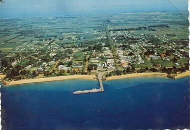 Phillip Island and District Historical Society Inc.
Photograph, 1960 - 1973
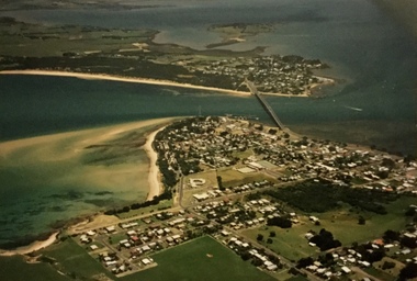
... Colour photograph - postcard - aerial view of Cowes..."Aerial view of Cowes"...Phillip Island and District Historical Society Inc. phillip-island-and-the-bass-coast One of a Postcard Series. local history newspapers aerial photograph cowes coloured photograph phillip island Jean Jamieson "Aerial view of Cowes" Colour photograph - postcard - aerial view of Cowes Photograph ...One of a Postcard Series.Colour photograph - postcard - aerial view of Cowes"Aerial view of Cowes"local history, newspapers, aerial photograph, cowes, coloured photograph, phillip island, jean jamieson -
Phillip Island and District Historical Society Inc.
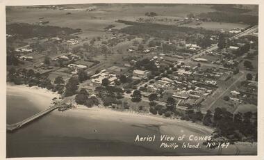
Photograph, circa 1940
... ...aerial views of cowes...Aerial view of Cowes Phillip Island No. 147...Bayview Guesthouse (lower right foreshore) was burnt down in 1950s. local history photography photographs slides film aerial views of cowes phillip island black & white photograph aerial views cowes Aerial view of Cowes Phillip Island No. 147 Jetty diagonally lower left - township in foreground - open paddocks in background. ...Commercially printed approx 1940s. Bayview Guesthouse (lower right foreshore) was burnt down in 1950s.Jetty diagonally lower left - township in foreground - open paddocks in background. Thompson Avenue & Cypress trees lower middle to upper right. Taken approx 1940sAerial view of Cowes Phillip Island No. 147local history, photography, photographs, slides, film, aerial views of cowes, phillip island, black & white photograph, aerial views cowes -
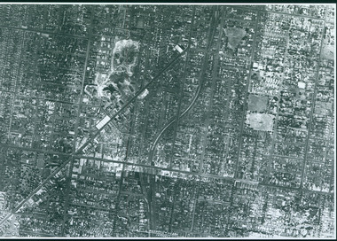
![Photograph - Aerial view of Sunshine, [1970s]](/media/collectors/5164c1772162ef0c64d700f2/items/69dc57946a5a9c1cb356d9b3/item-media/69dc597c6a5a9c1cb356eecf/item-fit-380x285.jpg?cb=6) Sunshine and District Historical Society Incorporated
Sunshine and District Historical Society IncorporatedPhotograph - Aerial view of Sunshine, [1970s]
... Aerial view of Sunshine...Aerial view of Sunshine...Aerial view of Sunshine business and residential district including railway line...Sunshine Overpass Bridge Hampshire Road Aerial view of Sunshine business and residential district including railway line Aerial view of Sunshine Photograph Aerial view of Sunshine ...Aerial view of Sunshine business and residential district including railway linesunshine, overpass, bridge, hampshire road -
 Lakes Entrance Historical Society
Postcard - Omeo Victoria c1940, H D Bulmer
... Black and white postcard showing an aerial view of the roads and country surrounding the mining town of Omeo Victoria...Aerial view of Omeo...Lakes Entrance Historical Society 4 Marine Parade Lakes Entrance gippsland Hotels Transport Aerial view of Omeo Black and white postcard showing an aerial view of the roads and country surrounding the mining town of Omeo Victoria Postcard Omeo Victoria c1940 H D Bulmer ...Black and white postcard showing an aerial view of the roads and country surrounding the mining town of Omeo VictoriaAerial view of Omeohotels, transport -
Glenelg Shire Council Cultural Collection
Photograph - Photograph - aerial view of Portland harbour, 1960
... Photograph - aerial view of Portland harbour...Black and white aerial view of harbour....Front: Harbour: Aerial view south. July '60 - typed, bottom....Photograph Photograph - aerial view of Portland harbour ...Port of Portland AuthorityFront: Harbour: Aerial view south. July '60 - typed, bottom.port of portland archives, aerial photography, portland harbour -
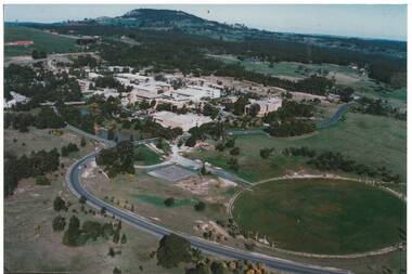 Buninyong & District Historical Society
Photograph - Colour Photograph of Mt Helen Campus, Aerial view of University of Ballarat, Mt. Helen Campus c1991
... Aerial view of University of Ballarat, Mt. Helen Campus c1991...Aerial view Mount Helen Campus c1991...Mt. Helen Campus. Aerial view to Mt. Buninyong c. 1991...Helen Campus Tertiary Education Mount Buninyong Rural Development Mt. Helen Campus. Aerial view to Mt. Buninyong c. 1991 Aerial view Mount Helen Campus c1991 Aerial view of University of Ballarat, Mt. ...Mount Helen Campus in its later building stages before becoming the University of Ballarat in 1994The University of Ballarat was formed from a number of varying types of tertiary schools, the earliest being the School of Mines in 1870 and finally became a University in 1994 Aerial view Mount Helen Campus c1991Mt. Helen Campus. Aerial view to Mt. Buninyong c. 1991university of ballarat, mt. helen campus, tertiary education, mount buninyong, rural development -
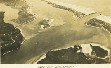 Lakes Entrance Historical Society
Postcard - Aerial view Lakes Entrance c1922, H D Bulmer, Roadnight Collection Postcards, 1922 c
... Aerial view Lakes Entrance c1922...Black and white postcard aerial view of the western area of the town, Bullock Island and Snake Island and waterways Lakes Entrance Victoria...Aerial View Lakes Entrance...Image clearly shows new alignment of Princes Highway around Jemmys Point and part of the original high road to the first bend above North Arm Bridge Waterways Islands Township Aerial View Lakes Entrance Black and white postcard aerial view of the western area of the town, Bullock Island and Snake Island and waterways Lakes Entrance Victoria Roadnight Collection Postcards Postcard Aerial view Lakes Entrance c1922 H D Bulmer ...Image clearly shows new alignment of Princes Highway around Jemmys Point and part of the original high road to the first bend above North Arm BridgeBlack and white postcard aerial view of the western area of the town, Bullock Island and Snake Island and waterways Lakes Entrance VictoriaAerial View Lakes Entrancewaterways, islands, township -
 Camberwell Historical Society
Photograph, Camberwell Victoria, aerial view of the District, c. 1940
... Camberwell Victoria, aerial view of the District...Print of photograph with inscription 'Camberwell Victoria, aerial view of the District, c. 1940' ...Camberwell Victoria, aerial view of the District, c. 1940...Camberwell Historical Society 25 Inglesby Road Camberwell melbourne Camberwell Camberwell Victoria, aerial view of the District, c. 1940 Print of photograph with inscription 'Camberwell Victoria, aerial view of the District, c. 1940' Camberwell Victoria, aerial view of the District Photograph Photograph ...Print of photograph with inscription 'Camberwell Victoria, aerial view of the District, c. 1940' Camberwell Victoria, aerial view of the District, c. 1940camberwell -
Federation University Historical Collection
Photograph, Mount Helen Campus Aerial Views, 10/1983
... Mount Helen Campus Aerial Views...Barker Library (top floor) Mount Helen goldfields buildings mount helen campus aerials Aerial Photos of the Mount Helen Campus Mount Helen Campus Aerial Views Photograph ...Aerial Photos of the Mount Helen Campusbuildings, mount helen campus, aerials -
Federation University Historical Collection
Photograph, Mount Helen Campus Aerial Views, 1984-1988
... Mount Helen Campus Aerial Views...Barker Library (top floor) Mount Helen goldfields buildings mount helen campus aerials Aerial Photos of the Mount Helen Campus Mount Helen Campus Aerial Views Photograph ...Aerial Photos of the Mount Helen Campusbuildings, mount helen campus, aerials -
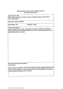 Eltham District Historical Society Inc
Document - Series Listing, Fraser Faithfull et al, Series 48: Aerial Views of Shire & Newly Completed Library, May 1994, 23 colour photographs, 2000
... Series 48: Aerial Views of Shire & Newly Completed Library, May 1994, 23 colour photographs...Includes views of Sugarloaf Reservoir, Petty's Orchard, Residential Areas, Shire Offices and New Library. shire of eltham archives series listing A4 printout Series 48: Aerial Views of Shire & Newly Completed Library, May 1994, 23 colour photographs Document Series Listing Fraser Faithfull Chris Marks ...Series consists of colour prints measuring from 215mm x 150mm up to 255mm x 200mm. Includes views of Sugarloaf Reservoir, Petty's Orchard, Residential Areas, Shire Offices and New Library.shire of eltham archives, series listing -
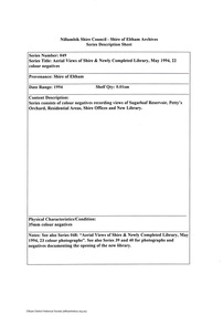 Eltham District Historical Society Inc
Document - Series Listing, Fraser Faithfull et al, Series 49: Aerial Views of Shire & Newly Completed Library, May 1994, 22 colour negatives, 2000
... Series 49: Aerial Views of Shire & Newly Completed Library, May 1994, 22 colour negatives...Eltham District Historical Society Inc 728 Main Rd Eltham melbourne Series consists of colour negatives recording views of Sugarloaf Reservoir, Petty's Orchard, Residential Areas, Shire Offices and New Library. shire of eltham archives series listing A4 printout Series 49: Aerial Views of Shire & Newly Completed Library, May 1994, 22 colour negatives Document Series Listing Fraser Faithfull Chris Marks ...Series consists of colour negatives recording views of Sugarloaf Reservoir, Petty's Orchard, Residential Areas, Shire Offices and New Library.shire of eltham archives, series listing -
 Ringwood and District Historical Society
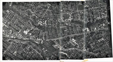
Photograph, Composite Aerial Views of Ringwood, Victoria - 1972
... Composite Aerial Views of Ringwood, Victoria - 1972...Two composite black & white aerial photographs with north-facing view over Maroondah Highway, including Railway Station precinct, Civic Centre precinct, Eastland, Mount Dandenong Road, Bedford Road, Ringwood Street, Warrandyte Road, Mullum Road, Loughnan's Road....Composite Aerial Views of Ringwood, Victoria - 1972 Photograph ...Two composite black & white aerial photographs with north-facing view over Maroondah Highway, including Railway Station precinct, Civic Centre precinct, Eastland, Mount Dandenong Road, Bedford Road, Ringwood Street, Warrandyte Road, Mullum Road, Loughnan's Road.Department of Crown Lands and Survey. Maroondah Highway Project - Run 3 - 20.1.72 - 3,900' ASL. -
 Ringwood and District Historical Society
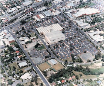
Photograph, Aerial Views of Eastland Precinct, Ringwood, Victoria - circa 1990
... Aerial Views of Eastland Precinct, Ringwood, Victoria - circa 1990...Two colour aerial photographs overlooking commercial area of Ringwood centred on Eastland shopping precinct (prior to Stage 2 extension proposed to commence in 1992). Aerial Views of Eastland Precinct, Ringwood, Victoria - circa 1990 Photograph ...Two colour aerial photographs overlooking commercial area of Ringwood centred on Eastland shopping precinct (prior to Stage 2 extension proposed to commence in 1992).Aerial Photography by R.J. Moss. -
 Federation University Historical Collection
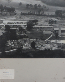
Photograph - Black and White, N. L. Harvey, Aerial Views of Mount Helen Campus, 1973, 1973
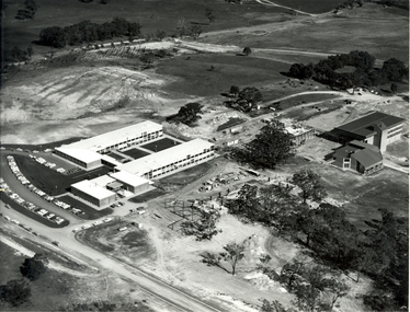
... Aerial Views of Mount Helen Campus, 1973...Three aerial photographs of the Mount Helen Stage 2 building activities * Westward view of Stage 2 buildings under construction, Aug 1973 * View to the South West showing Stage 2 buildings under construction, Aug 1973 * View to the North West showing Stage 2 buildings under construction, Aug 1973...Barker Library (top floor) Mount Helen goldfields The Stage 2 buildings at the Federation University Mount Helen Campus were underway in 1973. federation university federation university australia feduni university of ballarat Ballarat townscape mount helen construction stage 2 Three aerial photographs of the Mount Helen Stage 2 building activities * Westward view of Stage 2 buildings under construction, Aug 1973 * View to the South West showing Stage 2 buildings under construction, Aug 1973 * View to the North West showing Stage 2 buildings under construction, Aug 1973 Aerial Views of Mount Helen Campus, 1973 Photograph - Black and White N. ...The Stage 2 buildings at the Federation University Mount Helen Campus were underway in 1973.Three aerial photographs of the Mount Helen Stage 2 building activities * Westward view of Stage 2 buildings under construction, Aug 1973 * View to the South West showing Stage 2 buildings under construction, Aug 1973 * View to the North West showing Stage 2 buildings under construction, Aug 1973federation university, federation university australia, feduni, university of ballarat, ballarat townscape, mount helen, construction, stage 2 -
Glenelg Shire Council Cultural Collection
Photograph - Photograph - aerial view of Portland, 1960
... Photograph - aerial view of Portland...Black & white aerial view of Portland Harbour, looking south....Back: Aerial View South - July '60 -Top left, pencil...Photograph Photograph - aerial view of Portland ...Port of Portland Authority ArchivesBack: Aerial View South - July '60 -Top left, pencilport of portland archives, aerial photography, portland harbour -
Glenelg Shire Council Cultural Collection
Postcard - Postcard - Portland Harbour, c. 1970
... ... aerial view of Portland Harbour...Coloured photo postcard, serrated edge. Aerial view of Portland and harbour, 1970s...'Portland Vic, Aerial view of Portland Harbour'...'Portland Vic, Aerial view of Portland Harbour' Coloured photo postcard, serrated edge. ...Coloured photo postcard, serrated edge. Aerial view of Portland and harbour, 1970sBack: Maker details. 'Portland Vic, Aerial view of Portland Harbour'postcard, aerial view of portland harbour -
 Lakes Entrance Historical Society
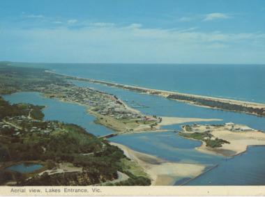
Postcard - Aerial view Lakes Entrance c1970, Murray View Gympie Qld, 1970 c
... Aerial view Lakes Entrance c1970...Black and white postcards showing aerial views of township, North Arm and Cunninghame Arm, Bullock Island and part of Kalimna Heights and Jemmys Point Lakes Entrance Victoria...Aerial view of Lakes Entrance Vic...Also a second postcard lookin west showing township, North Arm and Kalimna Heights 05213.1 10 x 15 cm Township Waterways Islands Aerial view of Lakes Entrance Vic Black and white postcards showing aerial views of township, North Arm and Cunninghame Arm, Bullock Island and part of Kalimna Heights and Jemmys Point Lakes Entrance Victoria Postcard Aerial view Lakes Entrance c1970 Murray View Gympie Qld ...Also a second postcard lookin west showing township, North Arm and Kalimna Heights 05213.1 10 x 15 cmBlack and white postcards showing aerial views of township, North Arm and Cunninghame Arm, Bullock Island and part of Kalimna Heights and Jemmys Point Lakes Entrance VictoriaAerial view of Lakes Entrance Victownship, waterways, islands -
 Phillip Island and District Historical Society Inc.
Photograph, Aerial photographs of Phillip Island, 1990s
... ...aerial views of phillip island...Coloured photographs showing aerial views of the townships and the Island....Phillip Island and District Historical Society Inc. phillip-island-and-the-bass-coast rhyll photographs cowes san remo newhaven aerial views of phillip island Coloured photographs showing aerial views of the townships and the Island. ...Coloured photographs showing aerial views of the townships and the Island.rhyll, photographs, cowes, san remo, newhaven, aerial views of phillip island -
Port Melbourne Historical & Preservation Society
Photograph - Photograph board, Seven aerial views of J Kitchen & Sons site, Port Melbourne, J Kitchen & Sons Pty Ltd. Port Melbourne 1951, 1951
... Photograph board, Seven aerial views of J Kitchen & Sons site, Port Melbourne...Port Melbourne 1951 Photograph Photograph board, Seven aerial views of J Kitchen & Sons site, Port Melbourne ...Large brown cardboard with seven (7) B&W aerial photographs pasted on it. Taken in 1951. Photo 1 - South East direction with Boundary Street in foreground, Kitchens buildings and Football Ground (cricket being played) Photo 2 - South West direction towards the Bay showing Station and Princes Piers, with ships in the distance. Photo 3 - almost directly above Kitchens Photo 4 - directly above kitchens Photo 5 - looking West including the Yarra River Photo 6 - looking North with Kitchen's storage and football ground in foreground Photo 7 - looking north east with football ground in foregrpound left and Yarra River top right.industry - manufacturing, built environment - industrial, piers and wharves - princes pier, piers and wharves - station pier, sport - australian rules football, sport - cricket, sport - recreational grounds, j kitchen & sons pty ltd, north port oval, port melbourne cricket ground -
Glenelg Shire Council Cultural Collection
Postcard - Postcard - Nelson, Victoria, n.d
... Coloured photo postcard, aerial view of Nelson, Victoria, showing the bridge, township and river mouth. ...Back: Maker details. 'Aerial view of Nelson Victoria'...Glenelg Shire Council Cultural Collection History House Cliff Street Portland great-ocean-road postcard Nelson Back: Maker details. 'Aerial view of Nelson Victoria' Coloured photo postcard, aerial view of Nelson, Victoria, showing the bridge, township and river mouth. ...Coloured photo postcard, aerial view of Nelson, Victoria, showing the bridge, township and river mouth. Rose Series De Luxe colorview NO 1213Back: Maker details. 'Aerial view of Nelson Victoria'postcard, nelson -
 Phillip Island and District Historical Society Inc.
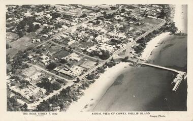
Photograph - Post Card, Unknown
... Black & White postcard showing an aerial view of Cowes Town Centre, beach and pier...."The Rose Series P. 1022" "Aerial view of Cowes, Phillip Island." "Airspy Photo"....Black & White postcard showing an aerial view of Cowes Town Centre, beach and pier. ...Donated by Stan McFee from the Keith McIlwraith Collection.Black & White postcard showing an aerial view of Cowes Town Centre, beach and pier."The Rose Series P. 1022" "Aerial view of Cowes, Phillip Island." "Airspy Photo".cowes phillip island, cowes foreshore and pier, phillip island, stan mcfee, keith mcilwraith collection -
 Phillip Island and District Historical Society Inc.
Photograph - Post Card, Early 1900's
... aerial view of cowes phillip island...Black & White postcard of an aerial view of Cowes. Jetty on the left - tree lined Thompson Avenue - Isle of Wight Hotel on the Esplanade left of Thompson Avenue and Bayview Guesthouse on the right on the Esplanade. ..."Aerial View of Cowes, Phillip Island. No. 147"...Phillip Island and District Historical Society Inc. phillip-island-and-the-bass-coast Photograph donated by Les Jones aerial view of cowes phillip island cowes township part cowes township - cowes beach and jetty phillip island les jones "Aerial View of Cowes, Phillip Island. ...Photograph donated by Les JonesBlack & White postcard of an aerial view of Cowes. Jetty on the left - tree lined Thompson Avenue - Isle of Wight Hotel on the Esplanade left of Thompson Avenue and Bayview Guesthouse on the right on the Esplanade. Township and farmland."Aerial View of Cowes, Phillip Island. No. 147"aerial view of cowes phillip island, cowes township, part cowes township - cowes beach and jetty, phillip island, les jones -
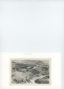
 Stawell Historical Society Inc
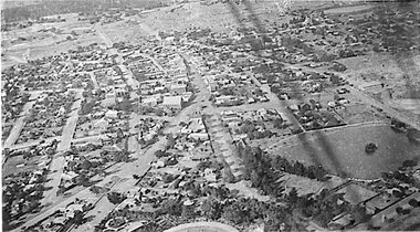
Photograph - 1919 Aerial View Over Stawell, Main Street Area Looking toward Big Hill 1919-- Aerial View
... 1919 Aerial View Over Stawell...Main Street Area Looking toward Big Hill 1919-- Aerial View...Aerial View – Main Street Area 1919 Looking toward Big Hill...Aerial View over Stawell taken by R J McClure 1919...Stawell Historical Society Inc 46 Longfield St Stawell grampians Aerial View – Main Street Area 1919 Looking toward Big Hill stawell Aerial View over Stawell taken by R J McClure 1919 Main Street Area Looking toward Big Hill 1919-- Aerial View Photograph 1919 Aerial View Over Stawell ...Aerial View – Main Street Area 1919 Looking toward Big HillAerial View over Stawell taken by R J McClure 1919stawell