Showing 110 items matching "allotment 12"
-
 Federation University Historical Collection
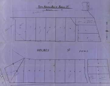
Map, Plan subdivision: Allotment 12 Holmes Street, Ballarat
... Plan subdivision: Allotment 12 Holmes Street, Ballarat......allotment 12...Some names are marked on the blocks - Taylor (9), Holmes (6), Robert Watson (3), Watson (16), Walter (18),Wetherly (11), Vacant (7) holmes street subdivision allotment 12 holmes taylor robert watson watson wetherly vacant North indicated with arrow Sizes of blocks - depth and width Blue paper with black ink showing the land blocks either side of Holmes Street Each block is numbered - 20 in all Names on some blocks Plan subdivision: Allotment 12 Holmes Street, Ballarat Map Map ...The Allotments drawn in Holmes Street appear to be hand drawn and showing one of the first subdivisions in Ballarat. This was begun in the 1860s. Some names are marked on the blocks - Taylor (9), Holmes (6), Robert Watson (3), Watson (16), Walter (18),Wetherly (11), Vacant (7)Blue paper with black ink showing the land blocks either side of Holmes Street Each block is numbered - 20 in all Names on some blocksNorth indicated with arrow Sizes of blocks - depth and width holmes street, subdivision, allotment 12, holmes, taylor, robert watson, watson, wetherly, vacant -
 Ringwood and District Historical Society
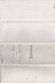
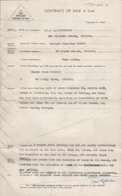
Legal record - Conditions of Sale (C.E.Carter), Ringwood - Crown Allotment 12, D Hodges to Unstated Purchaser - 1925
... Ringwood - Crown Allotment 12, D Hodges to Unstated Purchaser - 1925...Ringwood and District Historical Society 125A Warrandyte Road Ringwood North melbourne Particulars and Conditions of Sale of Property , from D Hodges to Unstated Ringwood - Crown Allotment 12, D Hodges to Unstated Purchaser - 1925 Legal record Conditions of Sale (C.E.Carter) ...Particulars and Conditions of Sale of Property , from D Hodges to Unstated -
 Greensborough Historical Society
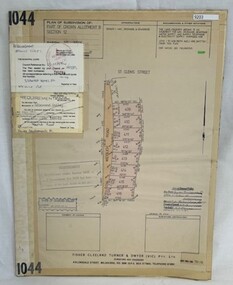
Poster - Planning Document, Shire of Diamond Valley et al, Subdivision Plan # 1044 - Parish of Nillumbik, County Bourke, Crown Allotment B Section 12, Eltham North, 1981-1987
... Subdivision Plan # 1044 - Parish of Nillumbik, County Bourke, Crown Allotment B Section 12, Eltham North....Subdivision Plan # 1044 - Parish of Nillumbik, County Bourke, Crown Allotment B Section 12, Eltham North. This subdivision plan includes Weidlich Road and St Clems Street. ...Greensborough Historical Society 34A Glenauburn Road Lower Plenty Lower Plenty melbourne Subdivision Plan # 1044 - Parish of Nillumbik, County Bourke, Crown Allotment B Section 12, Eltham North. This subdivision plan includes Weidlich Road and St Clems Street. ...Subdivision Plan # 1044 - Parish of Nillumbik, County Bourke, Crown Allotment B Section 12, Eltham North. This subdivision plan includes Weidlich Road and St Clems Street. The developer for this subdivision is Taunton Developments and the Surveyors are Fisher Cleeland Turner & Dwyer Vic, Surveyors and Engineers.An example of hard copy subdivision plans from the Greensborough area. Mainly from the Shire of Diamond Valley era (1964-1994).Plan (single sided) mounted on heavy card. Stamped and handwritten Council permissions, dates and other details. subdivision plans, shire of diamond valley, taunton developments -
 Greensborough Historical Society
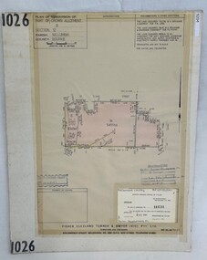
Poster - Planning Document, Shire of Diamond Valley et al, Subdivision Plan # 1026 - Parish of Nillumbik, County Bourke, Crown Allotment B Section 12, Eltham North, 1981-1984
... Subdivision Plan # 1026 - Parish of Nillumbik, County Bourke, Crown Allotment B Section 12, Eltham North....Subdivision Plan # 1026 - Parish of Nillumbik, County Bourke, Crown Allotment B Section 12, Eltham North. This subdivision plan includes Ryans Road (also known as Government Road) and St Clems Street. ...Greensborough Historical Society 34A Glenauburn Road Lower Plenty Lower Plenty melbourne Subdivision Plan # 1026 - Parish of Nillumbik, County Bourke, Crown Allotment B Section 12, Eltham North. This subdivision plan includes Ryans Road (also known as Government Road) and St Clems Street. ...Subdivision Plan # 1026 - Parish of Nillumbik, County Bourke, Crown Allotment B Section 12, Eltham North. This subdivision plan includes Ryans Road (also known as Government Road) and St Clems Street. The developer for this subdivision is Taunton Developments and the Surveyors are Fisher Cleeland Turner & Dwyer Vic, Surveyors and Engineers.An example of hard copy subdivision plans from the Greensborough area. Mainly from the Shire of Diamond Valley era (1964-1994).Plan (single sided) mounted on heavy card. Stamped and handwritten Council permissions, dates and other details. subdivision plans, shire of diamond valley, taunton developments -
 Greensborough Historical Society
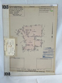
Poster - Planning Document, Shire of Diamond Valley et al, Subdivision Plan # 1018 - Parish of Nillumbik, County Bourke, Crown Allotment 4 Section 15, and Crown Allotment B Section 12, Eltham North, 1981-1982
... Subdivision Plan # 1018 - Parish of Nillumbik, County Bourke, Crown Allotment 4 Section 15, and Crown Allotment B Section 12, Eltham North....Subdivision Plan # 1018 - Parish of Nillumbik, County Bourke, Crown Allotment 4 Section 15, and Crown Allotment B Section 12, Eltham North. This subdivision plan includes Ryans Road (also known as Government Road) and St Clems Street. ...Greensborough Historical Society 34A Glenauburn Road Lower Plenty Lower Plenty melbourne Subdivision Plan # 1018 - Parish of Nillumbik, County Bourke, Crown Allotment 4 Section 15, and Crown Allotment B Section 12, Eltham North. This subdivision plan includes Ryans Road (also known as Government Road) and St Clems Street. ...Subdivision Plan # 1018 - Parish of Nillumbik, County Bourke, Crown Allotment 4 Section 15, and Crown Allotment B Section 12, Eltham North. This subdivision plan includes Ryans Road (also known as Government Road) and St Clems Street. The developer for this subdivision is Taunton Developments and the Surveyors are Fisher Cleeland Turner & Dwyer Vic, Surveyors and Engineers.An example of hard copy subdivision plans from the Greensborough area. Mainly from the Shire of Diamond Valley era (1964-1994).Plan (single sided) mounted on heavy card. Stamped and handwritten Council permissions, dates and other details. subdivision plans, shire of diamond valley, taunton developments -
Clunes Museum
Document - DOCUMENT - COVENANT, PRIMITIVE METHODIST CHAPEL
... COVENANT BETWEEN TALBOT LAND BUILDING INVESTMENT SOCIETY AND THE PRIMITIVE METHODIST CHAPEL IN CLUNES DATED 29/05/1877 FOR ALLOTMENT 12 SECTION 6....Clunes Museum 36 Fraser Street enter building through Collins Place Clunes goldfields LAND TO BUILD PRIMITIVE METHODIST CHAPEL ON PRIMITIVE METHODIST CHAPEL TALBOT LAND BUILDING AND INVESTMENT SOCIETY COVENANT BETWEEN TALBOT LAND BUILDING INVESTMENT SOCIETY AND THE PRIMITIVE METHODIST CHAPEL IN CLUNES DATED 29/05/1877 FOR ALLOTMENT 12 SECTION 6. PRIMITIVE METHODIST CHAPEL Document DOCUMENT - COVENANT ...LAND TO BUILD PRIMITIVE METHODIST CHAPEL ONCOVENANT BETWEEN TALBOT LAND BUILDING INVESTMENT SOCIETY AND THE PRIMITIVE METHODIST CHAPEL IN CLUNES DATED 29/05/1877 FOR ALLOTMENT 12 SECTION 6.primitive methodist chapel, talbot land building and investment society -
 The Beechworth Burke Museum Research Collection
Card (Series) - Index Card, George Tibbits, William Street, Beechworth, 1976
... Property - William St , Beechworth - Section 30, Town Allotment 12 - 125' x 200' Ownership details and history - 14 July 1864 - G. ...The Beechworth Burke Museum Research Collection 103 Ford Street Beechworth Property - William St , Beechworth - Section 30, Town Allotment 12 - 125' x 200' Ownership details and history - 14 July 1864 - G. ...George Tibbits, University of Melbourne. Faculty of Architecture, Building and Town & Regional PlanningIndex system that support the research for Beechworth : historical reconstruction / [by] George Tibbits ... [et al]Arranged by street names of BeechworthEach index card includes: street name and number of property, image of property, allotment and section number, property owners and dates of ownership, description of the property according to rate records, property floor plan with dimensions.beechworth, george tibbitsbeechworth, george tibbits -
 The Beechworth Burke Museum Research Collection
Card (Series) - Index Card, George Tibbits, Ford Street, Beechworth, 1976
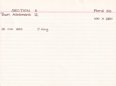
... Property - Ford Street Beechworth - Section 6, Town Allotment 12 - 100' x 250' Ownership details and history - 28 Oct 1853 - J. ...The Beechworth Burke Museum Research Collection 103 Ford Street Beechworth Property - Ford Street Beechworth - Section 6, Town Allotment 12 - 100' x 250' Ownership details and history - 28 Oct 1853 - J. ...George Tibbits, University of Melbourne. Faculty of Architecture, Building and Town & Regional PlanningIndex system that support the research for Beechworth : historical reconstruction / [by] George Tibbits ... [et al]Arranged by street names of BeechworthEach index card includes: street name and number of property, image of property, allotment and section number, property owners and dates of ownership, description of the property according to rate records, property floor plan with dimensions.beechworth, george tibbitsbeechworth, george tibbits -
 The Beechworth Burke Museum Research Collection
Card (Series) - Index Card, George Tibbits, 13 Kars Street, Beechworth, 1976
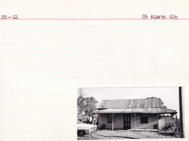
... Property - 13 Kars Street Beechworth - Section 31, Town Allotment 12 - 125' x 200' Ownership details and history - 6 Jan 1871 - E. ...The Beechworth Burke Museum Research Collection 103 Ford Street Beechworth Property - 13 Kars Street Beechworth - Section 31, Town Allotment 12 - 125' x 200' Ownership details and history - 6 Jan 1871 - E. ...George Tibbits, University of Melbourne. Faculty of Architecture, Building and Town & Regional PlanningIndex system that support the research for Beechworth : historical reconstruction / [by] George Tibbits ... [et al]Arranged by street names of BeechworthEach index card includes: street name and number of property, image of property, allotment and section number, property owners and dates of ownership, description of the property according to rate records, property floor plan with dimensions.beechworth, george tibbitsbeechworth, george tibbits -
 The Beechworth Burke Museum Research Collection
Card (Series) - Index Card, George Tibbits, 9 Stanley Road, Beechworth, 1976
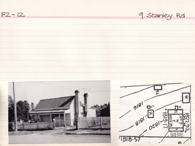
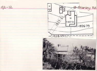
... Property - 9 Stanley Road (Lower Stanley Road) Beechworth - Section F2, Town Allotment 12 - 120' x 99' Ownership details and history - H.J. ...The Beechworth Burke Museum Research Collection 103 Ford Street Beechworth Property - 9 Stanley Road (Lower Stanley Road) Beechworth - Section F2, Town Allotment 12 - 120' x 99' Ownership details and history - H.J. ...George Tibbits, University of Melbourne. Faculty of Architecture, Building and Town & Regional PlanningIndex system that support the research for Beechworth : historical reconstruction / [by] George Tibbits ... [et al]Arranged by street names of BeechworthEach index card includes: street name and number of property, image of property, allotment and section number, property owners and dates of ownership, description of the property according to rate records, property floor plan with dimensions.beechworth, george tibbitsbeechworth, george tibbits -
 The Beechworth Burke Museum Research Collection
Card (Series) - Index Card, George Tibbits, Ford Street, Beechworth, 1976
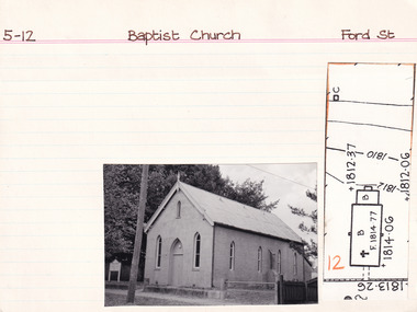
... Property - Baptist Church, Ford Street, Beechworth - Section 5, Town Allotment 12 - 100' x 250' Ownership details and history - 7 Sept 1853 - E. ...The Beechworth Burke Museum Research Collection 103 Ford Street Beechworth Property - Baptist Church, Ford Street, Beechworth - Section 5, Town Allotment 12 - 100' x 250' Ownership details and history - 7 Sept 1853 - E. ...George Tibbits, University of Melbourne. Faculty of Architecture, Building and Town & Regional PlanningIndex system that support the research for Beechworth : historical reconstruction / [by] George Tibbits ... [et al]Arranged by street names of BeechworthEach index card includes: street name and number of property, image of property, allotment and section number, property owners and dates of ownership, description of the property according to rate records, property floor plan with dimensions.beechworth, george tibbitsbeechworth, george tibbits -
 The Beechworth Burke Museum Research Collection
Card (Series) - Index Card, George Tibbits, 13 Stanley Road, Beechworth, 1976
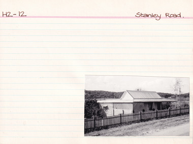
... Property - 13 Stanley Road (Lower Stanley Rd) - Section G2, Town Allotment 12 - 229.5 x 232.5 Ownership details and history - 23 April 1906 - R.M. ...The Beechworth Burke Museum Research Collection 103 Ford Street Beechworth Property - 13 Stanley Road (Lower Stanley Rd) - Section G2, Town Allotment 12 - 229.5 x 232.5 Ownership details and history - 23 April 1906 - R.M. ...George Tibbits, University of Melbourne. Faculty of Architecture, Building and Town & Regional PlanningIndex system that support the research for Beechworth : historical reconstruction / [by] George Tibbits ... [et al]Arranged by street names of BeechworthEach index card includes: street name and number of property, image of property, allotment and section number, property owners and dates of ownership, description of the property according to rate records, property floor plan with dimensions.beechworth, george tibbitsbeechworth, george tibbits -
 The Beechworth Burke Museum Research Collection
Card (Series) - Index Card, George Tibbits, Stanley Road, Beechworth, 1976
... Property - Stanley Road (Lower Stanley Rd) Beechworth - Sections H2, Suburban Allotment 12 - 259.5 x 644, 718 Ownership details and history - 2 Oct 1925 - E.J. ...The Beechworth Burke Museum Research Collection 103 Ford Street Beechworth Property - Stanley Road (Lower Stanley Rd) Beechworth - Sections H2, Suburban Allotment 12 - 259.5 x 644, 718 Ownership details and history - 2 Oct 1925 - E.J. ...George Tibbits, University of Melbourne. Faculty of Architecture, Building and Town & Regional PlanningIndex system that support the research for Beechworth : historical reconstruction / [by] George Tibbits ... [et al]Arranged by street names of BeechworthEach index card includes: street name and number of property, image of property, allotment and section number, property owners and dates of ownership, description of the property according to rate records, property floor plan with dimensions.beechworth, george tibbitsbeechworth, george tibbits -
 The Beechworth Burke Museum Research Collection
Card (Series) - Index Card, George Tibbits, 3 Bridge Street, Beechworth, 1976
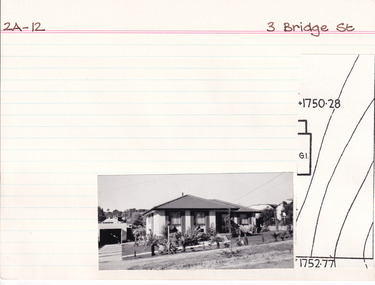
... Property - 3 Bridge Street Beechworth - Section 2A, Town Allotment 12 - 100' x 250' Ownership details and history - 24 Nov 1857 - H. ...The Beechworth Burke Museum Research Collection 103 Ford Street Beechworth Property - 3 Bridge Street Beechworth - Section 2A, Town Allotment 12 - 100' x 250' Ownership details and history - 24 Nov 1857 - H. ...George Tibbits, University of Melbourne. Faculty of Architecture, Building and Town & Regional PlanningIndex system that support the research for Beechworth : historical reconstruction / [by] George Tibbits ... [et al]Arranged by street names of BeechworthEach index card includes: street name and number of property, image of property, allotment and section number, property owners and dates of ownership, description of the property according to rate records, property floor plan with dimensions.beechworth, george tibbitsbeechworth, george tibbits -
 Bendigo Historical Society Inc.
Legal record - BOLTON William May - Agreement, Watson, James & Rogers, Rogers Collection, 1904 - 1905
... . * Sub-lease between W M Bolton and others to Gordon & Gotch concerning lease of Allotment 12, Section 51c, Parish of Bendigo, County of Bendigo. .... * Sub-lease between W M Bolton and others to Gordon & Gotch concerning lease of Allotment 12, Section 51c, Parish of Bendigo, County of Bendigo. ...In the early 1980s the firm of Watson, James & Rogers merged with the partnership of Every & Every and became the iconic “Rogers & Every” as known today. The firm is still located on Bull Street. https://rogersevery.com.au/about/* Agreement between Bolton Bros. and Alfred Fuller (Evening Mail Co.) Dated 1 June 1905. * Firms Act registration document registering Bolton Bros. * Register General' Office note confirming registration of Bolton Bros. 1904. * Sub-lease between W M Bolton and others to Gordon & Gotch concerning lease of Allotment 12, Section 51c, Parish of Bendigo, County of Bendigo. Dated January 1904.Signatureswatson james & rogers, bendigo, legal documents, bolton bros., evening mail co. -
 Bendigo Historical Society Inc.
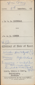
Document - H.A. & S.R. WILKINSON COLLECTION: CONTRACT OF SALE
... Reddie (buyer) for that piece of land that lies above the depth of 50 feet below the surface of lot 12 on plan of subdivision lodged at the office of titles in red ink No. 5394259 dated 19/1/1953 and being part of allotment 12 section 10 township Kangaroo Flat, together with all improvements thereon. ...Reddie (buyer) for that piece of land that lies above the depth of 50 feet below the surface of lot 12 on plan of subdivision lodged at the office of titles in red ink No. 5394259 dated 19/1/1953 and being part of allotment 12 section 10 township Kangaroo Flat, together with all improvements thereon. ...This business was owned by father and son, Henry Archibald Wilkinson and Samuel Ronald "Ron" Wilkinson. Henry (1882-1954) was born in Shepparton and died in Bendigo. He was married to Grace Hovendon in 1908. Samuel Ronald "Ron" (1914-1995), Henry's son, was married to Florence Jean McKerlie in 1937.Contract of sale of land dated 3rd December, 1953 between Mr. W.B. Nicholls (seller) and Mr. A.R. Reddie (buyer) for that piece of land that lies above the depth of 50 feet below the surface of lot 12 on plan of subdivision lodged at the office of titles in red ink No. 5394259 dated 19/1/1953 and being part of allotment 12 section 10 township Kangaroo Flat, together with all improvements thereon. Price 2,850 pounds.organization, business, h.a. & s.r wilkinson real estate -
 Bendigo Historical Society Inc.
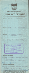
Document - H.A. & S.R. WILKINSON COLLECTION: CONTRACT OF SALE
... For property No.1 Edward Street, Bendigo being part of Crown allotment 12 section 125C described in certificate of title volume 6967 folio 283, together with blinds and electric light fittings and shades and all linos. ...For property No.1 Edward Street, Bendigo being part of Crown allotment 12 section 125C described in certificate of title volume 6967 folio 283, together with blinds and electric light fittings and shades and all linos. ...This business was owned by father and son, Henry Archibald Wilkinson and Samuel Ronald "Ron" Wilkinson. Henry (1882-1954) was born in Shepparton and died in Bendigo. He was married to Grace Hovendon in 1908. Samuel Ronald "Ron" (1914-1995), Henry's son, was married to Florence Jean McKerlie in 1937.Contract of sale dated 27th November, 1957 between Mr. F.L. Coppock (seller) and Mrs. A.E. Stafford (buyer). Solicitor for vendor: Messrs. Tatchell, Dunlop, Smalley & Balmer, Williamson Street, Bendigo. Solicitor for purchaser: Messrs. Tatchell, Dunlop, Smalley & Balmer, Williamson Street, Bendigo. For property No.1 Edward Street, Bendigo being part of Crown allotment 12 section 125C described in certificate of title volume 6967 folio 283, together with blinds and electric light fittings and shades and all linos. Price 950 pounds.organization, business, h.a. & s.r wilkinson real estate -
 Ringwood and District Historical Society
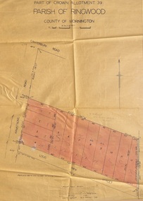
Map - Plan of Subdivision, Part of Crown Allotment 39, Parish of Ringwood, County of Mornington - 1949
... Map showing residential allotments numbered 1 to 12 on Armstrong Road and Louis Street, Heathmont, Victoria....Map showing residential allotments numbered 1 to 12 on Armstrong Road and Louis Street, Heathmont, Victoria. ...Map showing residential allotments numbered 1 to 12 on Armstrong Road and Louis Street, Heathmont, Victoria.Certification signed and dated by Russell Francis Kinnane, Licensed Surveyor, 18th February, 1949. -
 The Beechworth Burke Museum Research Collection
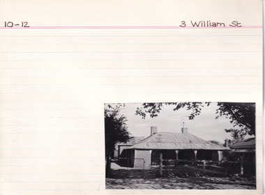
Card (Series) - Index Card, George Tibbits, 3 William Street, Beechworth, 1976
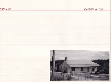
... Property - Section 10, Town Allotment 12 - 3 William Street, Beechworth 100 x 250 11-04-1856 D. ...The Beechworth Burke Museum Research Collection 103 Ford Street Beechworth Property - Section 10, Town Allotment 12 - 3 William Street, Beechworth 100 x 250 11-04-1856 D. ...George Tibbits, University of Melbourne. Faculty of Architecture, Building and Town & Regional PlanningIndex system that support the research for Beechworth : historical reconstruction / [by] George Tibbits ... [et al]Arranged by street names of BeechworthEach index card includes: street name and number of property, image of property, allotment and section number, property owners and dates of ownership, description of the property according to rate records, property floor plan with dimensions.beechworth, george tibbitsbeechworth, george tibbits -
 The Beechworth Burke Museum Research Collection
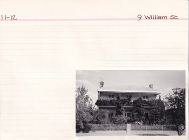
Card (Series) - Index Card, George Tibbits, 9 William Street, Beechworth, 1976
... Property - 9 William Street Beechworth, Section 11, Town Allotment 12, 100 x 250 Ownership details and history - 11 April 1856 - M. ...The Beechworth Burke Museum Research Collection 103 Ford Street Beechworth Property - 9 William Street Beechworth, Section 11, Town Allotment 12, 100 x 250 Ownership details and history - 11 April 1856 - M. ...George Tibbits, University of Melbourne. Faculty of Architecture, Building and Town & Regional PlanningIndex system that support the research for Beechworth : historical reconstruction / [by] George Tibbits ... [et al]Arranged by street names of BeechworthEach index card includes: street name and number of property, image of property, allotment and section number, property owners and dates of ownership, description of the property according to rate records, property floor plan with dimensions.beechworth, george tibbitsbeechworth, george tibbits -
 Bendigo Historical Society Inc.
Document - H. A. & S. R. WILKINSON COLLECTION: CONTRACT OF SALE
... Property: that piece of land part of Crown allotment 12 section 19B Parish of Sandhurst City of Bendigo, land described in certificate of title volume 2734 folio 653 and situate No. 30 Shamrock street, Bendigo, together with 5 roomed weatherboard dwelling and all sundry outbuildings, also electric stovette, electric copper, all electric light fittings and shades, rotary clothes line, all blinds and linos. ...Property: that piece of land part of Crown allotment 12 section 19B Parish of Sandhurst City of Bendigo, land described in certificate of title volume 2734 folio 653 and situate No. 30 Shamrock street, Bendigo, together with 5 roomed weatherboard dwelling and all sundry outbuildings, also electric stovette, electric copper, all electric light fittings and shades, rotary clothes line, all blinds and linos. ...Contract of sale of land dated 20th May, 1954 between Mrs. B. S. Grant (vendor) and Mr. J. C. & Mrs. V. C. Tarr (purchaser). Solicitors for vendor: Noel & Woodward. Solicitor for purchaser: T. M. Williams, Watson & James. Property: that piece of land part of Crown allotment 12 section 19B Parish of Sandhurst City of Bendigo, land described in certificate of title volume 2734 folio 653 and situate No. 30 Shamrock street, Bendigo, together with 5 roomed weatherboard dwelling and all sundry outbuildings, also electric stovette, electric copper, all electric light fittings and shades, rotary clothes line, all blinds and linos. Price: 2,000 pounds.organization, business, h.a. & s.r wilkinson real estate -
 The Beechworth Burke Museum Research Collection
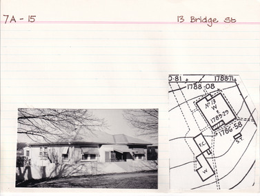
Card (Series) - Index Card, George Tibbits, 13 Bridge Street, Beechworth, 1976
... Maxham 1876 - Allotments 11, 12, 13, 14 & 15 - Prem 33'x14' WB + shingle roof. ...Maxham 1876 - Allotments 11, 12, 13, 14 & 15 - Prem 33'x14' WB + shingle roof. ...George Tibbits, University of Melbourne. Faculty of Architecture, Building and Town & Regional PlanningIndex system that support the research for Beechworth : historical reconstruction / [by] George Tibbits ... [et al]Arranged by street names of BeechworthEach index card includes: street name and number of property, image of property, allotment and section number, property owners and dates of ownership, description of the property according to rate records, property floor plan with dimensions.beechworth, george tibbitsbeechworth, george tibbits -
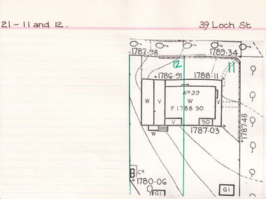 The Beechworth Burke Museum Research Collection
Card (Series) - Index Card, George Tibbits, 39 Loch Street, Beechworth, 1976
... Property - 39 Loch Street, Beechworth - Section 21, Town Allotments 11 and 12 - 200' x 250' Ownership details and history - 4 Apr 1857 - J.A. ...The Beechworth Burke Museum Research Collection 103 Ford Street Beechworth Property - 39 Loch Street, Beechworth - Section 21, Town Allotments 11 and 12 - 200' x 250' Ownership details and history - 4 Apr 1857 - J.A. ...George Tibbits, University of Melbourne. Faculty of Architecture, Building and Town & Regional PlanningIndex system that support the research for Beechworth : historical reconstruction / [by] George Tibbits ... [et al]Arranged by street names of BeechworthEach index card includes: street name and number of property, image of property, allotment and section number, property owners and dates of ownership, description of the property according to rate records, property floor plan with dimensions.beechworth, george tibbitsbeechworth, george tibbits -
 Bendigo Historical Society Inc.
Document - H. A. & S. R. WILKINSON COLLECTION: CONTRACT OF SALE
... Property: that piece of land being part of Crown allotment 12 section 125C Parish of Sandhurst City of Bendigo, land being described in certificate of title volume 084 folio 756 and situate No. 37 Garsed Street Corner Edward Street, Bendigo, together with 6 roomed brick dwelling and all sundry outbuildings, also all blinds, all linos with the exception of lino in the lounge, all electric light fittings and shades with the exception of those in the hall and gas griller. ...Property: that piece of land being part of Crown allotment 12 section 125C Parish of Sandhurst City of Bendigo, land being described in certificate of title volume 084 folio 756 and situate No. 37 Garsed Street Corner Edward Street, Bendigo, together with 6 roomed brick dwelling and all sundry outbuildings, also all blinds, all linos with the exception of lino in the lounge, all electric light fittings and shades with the exception of those in the hall and gas griller. ...Contract of sale of land dated 15th December, 1955 between Mrs. B. J. Meehan (vendor) and Mrs. M. C. Thomson (purchaser). Property: that piece of land being part of Crown allotment 12 section 125C Parish of Sandhurst City of Bendigo, land being described in certificate of title volume 084 folio 756 and situate No. 37 Garsed Street Corner Edward Street, Bendigo, together with 6 roomed brick dwelling and all sundry outbuildings, also all blinds, all linos with the exception of lino in the lounge, all electric light fittings and shades with the exception of those in the hall and gas griller. Price: 2,300 pounds. Attached 2 copies of letter signed by Mrs. B. J. Meehan giving Mrs. Thomson the option to purchase the property for the sum of 2,350 pounds until 6PM Wednesday 14th December, 1995, the letter is dated 12th December, 1955.organization, business, h.a. & s.r wilkinson real estate -
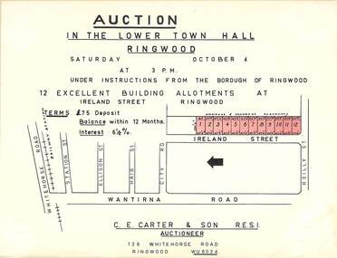 Ringwood and District Historical Society
Flyer, Building Allotments Auction Notice - Ireland Street, Ringwood, Victoria - circa 1960
... Notice attached to light cardboard backing advertising auction in the lower town hall, Ringwood, at 3pm, Saturday October 4 (1958?) for 12 building allotments in Ireland Street, Ringwood. ...Notice attached to light cardboard backing advertising auction in the lower town hall, Ringwood, at 3pm, Saturday October 4 (1958?) for 12 building allotments in Ireland Street, Ringwood. ...Notice attached to light cardboard backing advertising auction in the lower town hall, Ringwood, at 3pm, Saturday October 4 (1958?) for 12 building allotments in Ireland Street, Ringwood. Locality plan with red shading highlighting sites for auction in Ireland Street under instructions from the Borough of Ringwood. (Agent) C.E. Carter & Son, 126 Whitehorse Road, Ringwood (Phone) WU 6024. -
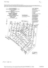 Ringwood and District Historical Society
Document - Subdivision Plan, LP26914 Multiple Crown Allotments, Parish of Ringwood, County of Mornington, Vol 8021 Fol 053 - 1954
... Section C Crown Allotments 3, 12 & part of 2. Section B Map includes Bedford Road, Government Road (later Bedford Park Road then Hill Street), Marwarra Street and Tooronga Road, Ringwood. ...Section C Crown Allotments 3, 12 & part of 2. Section B Map includes Bedford Road, Government Road (later Bedford Park Road then Hill Street), Marwarra Street and Tooronga Road, Ringwood. ...LANDATA Land Victoria plan printout dated 2010Part of Crown Allotments 1, 1A, 2, 3, 4, 5, 6, 7, 8, 9, 10, 55, 56, 57. Section C Crown Allotments 3, 12 & part of 2. Section B Map includes Bedford Road, Government Road (later Bedford Park Road then Hill Street), Marwarra Street and Tooronga Road, Ringwood. (Sheet 1 of 2 - Sheet 2 not included with collection). -
 Bendigo Historical Society Inc.
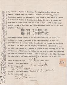
Document - EDWIN BUCKLAND COLLECTION: AGREEMENT BY HAROLD E. TAYLOR AND VICTOR P. BUCKLAND
... Buckland re leasing of land Allotment 3, Section 3 12 Parish of Goornong, Containing 301 acres 3 roods for the term of Three years....Buckland re leasing of land Allotment 3, Section 3 12 Parish of Goornong, Containing 301 acres 3 roods for the term of Three years. ...Document. Agreement by Harold E. Taylor and Victor P. Buckland re leasing of land Allotment 3, Section 3 12 Parish of Goornong, Containing 301 acres 3 roods for the term of Three years. -
 The Beechworth Burke Museum Research Collection
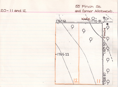
Card (Series) - Index Card, George Tibbits, 55 Finch Street, Beechworth (and corner allotment), 1976
... Property - 55 Finch Street, Beechworth (Cnr Kars and Finch Sts) - Section 20, Allotment 11 and 12 - 2 x (100' x 250') Ownership details and history 20-11 12 Oct 1857 - L. ...The Beechworth Burke Museum Research Collection 103 Ford Street Beechworth Property - 55 Finch Street, Beechworth (Cnr Kars and Finch Sts) - Section 20, Allotment 11 and 12 - 2 x (100' x 250') Ownership details and history 20-11 12 Oct 1857 - L. ...George Tibbits, University of Melbourne. Faculty of Architecture, Building and Town & Regional PlanningIndex system that support the research for Beechworth : historical reconstruction / [by] George Tibbits ... [et al]Arranged by street names of BeechworthEach index card includes: street name and number of property, image of property, allotment and section number, property owners and dates of ownership, description of the property according to rate records, property floor plan with dimensions.beechworth, george tibbitsbeechworth, george tibbits -
 Bendigo Historical Society Inc.
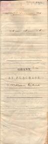
Document - JOHANSON COLLECTION: GRANT BY PURCHASE WILLIAM ROBERTS
... Document details purchase of land by above William Roberts of Heathcote, for the sum of two pounds, 12 shillings. Allotment 7, section 12, Township of Heathcote. ...Document details purchase of land by above William Roberts of Heathcote, for the sum of two pounds, 12 shillings. Allotment 7, section 12, Township of Heathcote. ...Legal document. On front: Dated 17th December 1855. Ac1 R1 P 1. ( acres, roods, perches ) Grant by purchase to William Roberts. In pencil Allot 7 of Sec 12. Inside: 'Victoria - Township Lot. Grantee W. Roberts. Document details purchase of land by above William Roberts of Heathcote, for the sum of two pounds, 12 shillings. Allotment 7, section 12, Township of Heathcote. Land sold as Lot 14. Dated 30 July 1855. Signed by C.W. Hotham ( Sir Charles Hotham ) Property is now 42 Beauchamp Street, Heathcote ( Landata research, 28.3.2017, https://www.landata.vic.gov.au/tpc_confirm_map.aspx?pfi=45257085 )heathcote, land sale, william roberts -
![Escol Estate [Kew], 1940](/media/collectors/550653872162f11fb04854aa/items/59115843d0ce2b1f048f0fbb/item-media/591158fdd0ce2e1f04f1e0f5/item-fit-380x285.jpg?cb=6) Kew Historical Society Inc
Kew Historical Society IncPlan - Subdivision Plan, Escol Estate [Kew], 1940, 1940
... At the auction of the lots in May 1940, eight of the 12 allotments were sold. The land was sold subject to a restriction of only one private residence being erected on each lot....At the auction of the lots in May 1940, eight of the 12 allotments were sold. The land was sold subject to a restriction of only one private residence being erected on each lot. ...Pru Sanderson, in her groundbreaking ‘City of Kew Urban Conservation Study : Volume 2 - Development History’ (1988), summarised the periods of urban development and subdivisions of land in Kew. The periods that she identified included 1845-1880, 1880-1893, 1893-1921, 1921-1933, 1933-1943, and Post-War Development. These periods were selected as they represented periods of rapid growth or decline in urban development. An obvious starting point for Sanderson’s groupings involved population growth and the associated economic cycles. These cycles also highlighted urban expansion onto land that was predominantly rural, although in other cases it represented the decline and breakup of large estates. A number of the plans in the Kew Historical Society’s collection can also be found in other collections, such as those of the State Library of Victoria and the Boroondara Library Service. A number are however unique to the collection.The Kew Historical Society collection includes almost 100 subdivision plans pertaining to suburbs of the City of Melbourne. Most of these are of Kew, Kew East or Studley Park, although a smaller number are plans of Camberwell, Deepdene, Balwyn and Hawthorn. It is believed that the majority of the plans were gifted to the Society by persons connected with the real estate firm - J. R. Mathers and McMillan, 136 Cotham Road, Kew. The Plans in the collection are rarely in pristine form, being working plans on which the agent would write notes and record lots sold and the prices of these. The subdivision plans are historically significant examples of the growth of urban Melbourne from the beginning of the 20th Century up until the 1980s. A number of the plans are double-sided and often include a photograph on the reverse. A number of the latter are by noted photographers such as J.E. Barnes.The ‘Escol Estate’ was a subdivision, which created Bramley Court, which runs south from Sackville Street between Evans Road and Orford Avenue. The subdivision was comprised of 12 lots. At the auction of the lots in May 1940, eight of the 12 allotments were sold. The land was sold subject to a restriction of only one private residence being erected on each lot.subdivision plans - kew, sackville street – kew (vic.), bramley court – kew (vic.)