Showing 153 items matching "armstrong creek"
-
 Marysville & District Historical Society
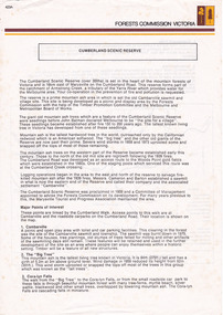
Flyer (item) - Information Flyer, Forests Commission, Victoria, Cumberland Scenic Reserve, 1918-1983
... ...armstrong creek...This reserve forms part of the catchment of Armstrong Creek, a tributary of the Yarra River which provides water for the Melbourne area. ...This reserve forms part of the catchment of Armstrong Creek, a tributary of the Yarra River which provides water for the Melbourne area. ...An information flyer that was produced as a guide to the Cumberland Scenic Reserve by the Forests Commission of Victoria. The Forests Commission Victoria (FCV) was the main government authority responsible for management and protection of State forests in Victoria, Australia between 1918 and 1983. The Commission was responsible for ″forest policy, prevention and suppression of bushfires, issuing leases and licences, planting and thinning of forests, the development of plantations, reforestation, nurseries, forestry education, the development of commercial timber harvesting and marketing of produce, building and maintaining forest roads, provision of recreation facilities, protection of water, soils and wildlife, forest research and making recommendations on the acquisition or alienation of land for forest purposes″. The Cumberland Scenic Reserve is set in the heart of the mountain forests of Victoria and is 16km east of Marysville on the Cumberland Road. This reserve forms part of the catchment of Armstrong Creek, a tributary of the Yarra River which provides water for the Melbourne area. The reserve is a prime mountain ash area in which is set the old Cambarville sawmill and village site.An information flyer that was produced as a guide to the Cumberland Scenic Reserve by the Forests Commission of Victoria. 423Aforests commission victoria, cumberland scenic reserve, marysville, victoria, cambarville, the big tree, cora-lyn falls, barton's lookout, cumberland falls, sovereign view, armstrong creek, yarra river, mountain ash -
 Federation University Historical Collection
Document, Ken Clements, Peterborough Puzzles, 2009, 2009
... ...armstrong creek...This paper by Ken Clements considers the origin of the term martyr in connection to this location, and where the Aboriginal massacre may have taken place. aborigines bay of martyrs massacre bay massacre hill buckley creek run pioneer pastoralists british traversers settlers peterborough maps tourism history method childers cove barque children murnane bay sandy bay dog trap bay buckley creek viviennes lookeout stanhope bay buttres bay burnies beach armstrong creek flaxman hill antares rock lovers nook crofts bay clements worm bay halladale point the well wold dog cove james irvine monument curdies inlet squirrel creek wallaby creek boggy creek whiskey creek pioneer beach schomberg rock young australia spit crown of thorns newfield bay the grotto london bridge point hesse high cliffs the arch Cape Martyr Little massacre bay Aboriginal Massacre ken clements Thirteen page document by Ken Clements relating to Peterborough, Victoria. ...Massacre Bay is located on Victoria's Great Ocean Road, and is in the centre of the Bay of Martyrs. The bay consists of 20 m high, red limestone bluffs. This paper by Ken Clements considers the origin of the term martyr in connection to this location, and where the Aboriginal massacre may have taken place. Thirteen page document by Ken Clements relating to Peterborough, Victoria. Contents include coastal features, local Aborigines, Bay of Martyrs, Massacre Bay, Massacre Hill, Buckley Creek Run, Pioneer Pastoralists, British Traversers, settlers, Peterborough, Maps, tourism, history method. Photographs by Laurie Moore.aborigines, bay of martyrs, massacre bay, massacre hill, buckley creek run, pioneer pastoralists, british traversers, settlers, peterborough, maps, tourism, history method, childers cove, barque children, murnane bay, sandy bay, dog trap bay, buckley creek, viviennes lookeout, stanhope bay, buttres bay, burnies beach, armstrong creek, flaxman hill, antares rock, lovers nook, crofts bay, clements, worm bay, halladale point, the well, wold dog cove, james irvine monument, curdies inlet, squirrel creek, wallaby creek, boggy creek, whiskey creek, pioneer beach, schomberg rock, young australia, spit, crown of thorns, newfield bay, the grotto, london bridge, point hesse, high cliffs, the arch, cape martyr, little massacre bay, aboriginal massacre, ken clements -
 Eltham District Historical Society Inc
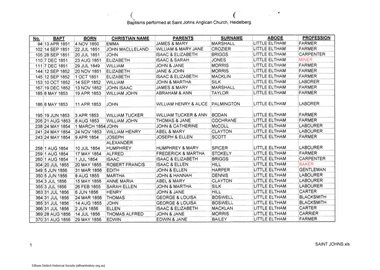
Folder, Eric Tetlow, Baptisms performed at St John's Anglican Church Heidelberg, 2006
... creek...armstrong...A significant resource which pulls together names of pioneer families for the area during its early European settlement. harry gilham collection st john's anglican church heidelberg diamond creek armstrong bailey bennett benson blackman bodan booth bozwell briggs chad clark clayton cochrane crozier dennis ewing fowler haley harper heley hill irish jones kaylock kerr keylock macklin mccoll mitchell morris palmington scott silk spicer stokely taylor thornburn thorborne waterton wills marshall little eltham HG Booklet 41 4 pages Baptisms performed at St John's Anglican Church Heidelberg Folder Eric Tetlow ...List of baptisms of Little Eltham residents 1850-1860 and Diamond Creek 1850-1862 at St John's Anglican Church Heidelberg. Includes names of about 80 children whose abode was given as Diamond Creek or Little Eltham. Printout of spreadsheet listing number, date of baptism, birth date, christian name, names of parents, abode and profession. Baptisms performed at Saint John's Anglican Church Heidelberg. Arranged in date order. Includes hand written contextual notes by Harry Gilham. Copy provided to Jock Ryan, President of the Nillumbik Historical Society in 2006. Additional notes by Harry Gilham, 2012: Compiled by the late Eric Tetlow, Secretary, Yarra Glen and District Historical Society who, working at St John's Church of England Heidelberg in their archives in 2006, discovered files which he colated into this spreadsheet document of Baptisms relating to Little Eltham and Diiamond Creek. St John's Heidelberg is the original source of information.A significant resource which pulls together names of pioneer families for the area during its early European settlement.4 pagesHG Booklet 41harry gilham collection, st john's anglican church heidelberg, diamond creek, armstrong, bailey, bennett, benson, blackman, bodan, booth, bozwell, briggs, chad, clark, clayton, cochrane, crozier, dennis, ewing, fowler, haley, harper, heley, hill, irish, jones, kaylock, kerr, keylock, macklin, mccoll, mitchell, morris, palmington, scott, silk, spicer, stokely, taylor, thornburn, thorborne, waterton, wills, marshall, little eltham -
 Stawell Historical Society Inc
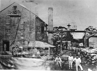
Photograph, Fountain Head Brewery in Armstrong is established by Mr Jens Kofoed
... Armstrong. The brewery is close to two streams which joined the Concongella Creek near Armstrong. ...Armstrong. The brewery is close to two streams which joined the Concongella Creek near Armstrong. ...Photo of three story brick building with extra room in the roof area. The tall brick chimney stack is behind an overhead tramway. Fountain Head Brewery Armstrong was established by Jens Kofoed Brewery Armstrong. The brewery is close to two streams which joined the Concongella Creek near Armstrong. Jens Kofoed was a shipwright from the Netherlands and came to the area in 1860. The brewery employed a number of people for about 40 years and closed about 1900.Black and white photograph of a brick brewery three stories with a large brick chimney. Workmen about in many places with overhead tramway.stawell industry ararat -
 Stawell Historical Society Inc
Photograph, Fountain Head Brewery at Armstrong 1866
... Armstrong as commissioned by the Shire of Stawell for the Inter-colonial and Paris Exhibition in Melbourne in 1866. The brewery, a three-storey high building, was established close to two streams which joined the Concongella Creek near Armstrong, although the water required to run the brewery was obtained from a natural underground spring which is still visible. ...Armstrong as commissioned by the Shire of Stawell for the Inter-colonial and Paris Exhibition in Melbourne in 1866. The brewery, a three-storey high building, was established close to two streams which joined the Concongella Creek near Armstrong, although the water required to run the brewery was obtained from a natural underground spring which is still visible. ...Fountain Head Brewery Armstrong's. Part of a collection of Photographs by Mr. O.G. Armstrong as commissioned by the Shire of Stawell for the Inter-colonial and Paris Exhibition in Melbourne in 1866. The brewery, a three-storey high building, was established close to two streams which joined the Concongella Creek near Armstrong, although the water required to run the brewery was obtained from a natural underground spring which is still visible. Further findings of Gold in Victoria around 1859-1860 brought a large rush of miners to the area. Some stayed on to become merchants, farmers, etc. Jens Kofoed, a shipwright from the Netherlands, was one who came to the area at this time. He and his family move to Armstrong in 1860, establishing the Fountain Head Brewery, which employed quite a number of people for about 40 years. stawell industry -
 Victorian Interpretive Projects Inc.
Photograph - Colour, Clare Gervasoni, Drystone wall at White Flat, Ballarat, 07/10/2012
... #cite_note-0 Ballarat White Flat White Flat Sports Ground Hickman Street South Street Armstong Street oval cricket football White Flat Drainage Yarrowee Creek drystone bluestone Five colour digital imaged of a bluestone drystone wall at White Flat, Ballarat. The drystone wall is on the steep embankment between Hickman Street and Armstrong Street South. ...White Flat was an early gold diggings. As early as 1856 the White Flat Drainage and Mining Co. constructed water races, drained the swampy land, and changed the course of the Yarrowee Creek. This may be remnants of that work. See http://bih.ballarat.edu.au/index.php/White_Flat_Drainage_and_Mining_Co.#cite_note-0 Five colour digital imaged of a bluestone drystone wall at White Flat, Ballarat. The drystone wall is on the steep embankment between Hickman Street and Armstrong Street South. ballarat, white flat, white flat sports ground, hickman street, south street, armstong street, oval, cricket, football, white flat drainage, yarrowee creek drystone, bluestone -
 Bendigo Historical Society Inc.
Document - RESEARCH NOTES: ONE TREE HILL, STORMWATER CHANNEL, ANTHONY TROILLOPE, HORSE TRAMWAY TO GOLDEN SQUARE
... Armstrong Brothers Mr Abraham Solomen Mr Bladiere Mr R T Wheeler Typed and handwritten notes. Mentioned are: - Some Notes Concerning The Eaglehawk Logs, Damaging the Stormwater Channel, where some Chinese were digging away the Creek, the cutting down of the giant gum tree which gave One Tree Hill its name, How Anthony Trollope saw Bendigo in the 1870's, A Proposed Horse Tramway to Golden Square, Society’s' Trip to Bridgewater Flour Mill, A talk on a trip to Malaya by Mr D Hester, Society News and Happenings, Old Bendigonians and Safety Cages, Document RESEARCH NOTES: ONE TREE HILL, STORMWATER CHANNEL, ANTHONY TROILLOPE, HORSE TRAMWAY TO GOLDEN SQUARE ...Typed and handwritten notes. Mentioned are: - Some Notes Concerning The Eaglehawk Logs, Damaging the Stormwater Channel, where some Chinese were digging away the Creek, the cutting down of the giant gum tree which gave One Tree Hill its name, How Anthony Trollope saw Bendigo in the 1870's, A Proposed Horse Tramway to Golden Square, Society’s' Trip to Bridgewater Flour Mill, A talk on a trip to Malaya by Mr D Hester, Society News and Happenings, Old Bendigonians and Safety Cages,document, various notes, eaglehawk logs, bendigo advertiser 19/10/1858, damaging the stormwater channel, bendigo advertiser 11/8/1872, harneys bridge, gas works, constable rogers, constable james bradley, joch, john o'c hattam, one tree hill, ryan, trollope's fabulous bendigo, anthony trollope, 'trollope’s australia', nelson press, alex h stone, bendigo advertiser 5/7/1897, mr peter ellis, cr hoskins, horse tramway, historical society, water wheel flour mill, june parry, mr pat wodetzki, mr leo wodetzki, neil murray, mr k hester, mr wes harry, mr i hendry, mr henry jackson, mr connelly, mr irons, mr harney, dr smith, dr hoyle, rev dr bachaus, rev dr nish, rev joseph dare, hon angus mackay, mr haverfield, mr j k robshaw, w p neal, mr george lansell, hon j h abbott, m l c, mr j casey, dr james boyd, dr atkinson, dr easie, mr t h henderson, old beehive, francis brothers, mr john crowley, mr jacob cohn, art gallery, mr hugh mcdevitt, mr alexander bayne, mr f sciallero, camp reserve, hon w i winter-irvine, mr george avery fletcher, great central goldfield of victoria, safety cages, bendigo advertiser, j h seymour, mr horwood, new chum and victoria tribute company, james watson, seymour's patent safety cage, londerry tribute, national show sandhurst, h banfield, mr a llewllyn, 'dear old bendigo', thomas bracken, mr william heffernan, mr edward (ned) ryan, mr samuel bastard, mr charles bird, mcpherson and co, fern hill club, mr george tolhurst, tolhurst brothers, union bank, mr lawrence ryan, mr shadrack jones, charley armstrong, armstrong brothers, mr abraham solomen, mr bladiere mr r t wheeler -
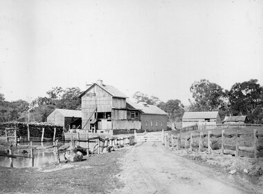
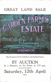 Ringwood and District Historical Society
Pamphlet, G.A. Green, Auction Sale Brochure - Garden Farms Estate, Ringwood, Victoria - 1919, 1919
... (Image) Cultivation Field - Potatoes on Lot 28 (Image) Picture of Bayswater Creek Flats. (Image) View from "Korumbeen" where Mr. Armstrong lived on Garden Farms Estate. ...(Image) Cultivation Field - Potatoes on Lot 28 (Image) Picture of Bayswater Creek Flats. (Image) View from "Korumbeen" where Mr. Armstrong lived on Garden Farms Estate. ...Multi-fold brochure advertising public auction of one-acre, 2-acre, 5-acre and 8-acre allotments in Ringwood and Bayswater on Saturday 12th April, 1919. Brochure includes terms of sale, description of subdivision features and local facilities, and photographic images of the area.Subdivison includes Canterbury Road Heathmont, Armstrong Road Heathmont, Armstrong Road Bayswater, Bungalook Road Heathmont, Bungalook Road Bayswater, and Orchard Road Bayswater. Road shown as Bayswater Road to Bayswater became Mountain Highway Bayswater. Vendor: H.E.B.Armstrong, Auctioneers: Coghill & Haughton, 79 Swanston Street Melbourne, Telephone Central 2793, in conjunction with J.B. McAlpin, Ringwood, Opposite Station, Telephone Ringwood 7. (Map) Woodcock & McCormack, Civil Engineers Architects & Surveyors, 430 Little Collins Street, Melbourne, Phone 3241 Central. MOST OF THE MONEY COMES OUT OF THE LAND. And more money can be obtained from anb acre of fruit than from an acre of any other produce. But you do not have to grow fruit on Garden Farms Estate. You can go in for - Outer Suburban Home - Market Garden - Orchard - Pig Raising - Poultry Farm - Small Dairy Farm - Small Fruits - Floral Culture - Scent and Bee Farm - Or just for a Week-end Home. RINGWOOD - THE PLACE TO LIVE. The Beautiful Ringwood District has so many natural attractions, that half a Land Agent's work is done in just showing a prospective buyer round and about. Ringwood has a pull of its own that attracts folk, proved beyond doubt by its rapid development within the last decade (spite the war). First, it is high and healthy, picturesque and undulating, convenient of access, sufficiently close to the Metropolis for City and Business folk to live at Ringwood. Its development is solid, because most of its people are industrious husbandmen, real producers, who have turned idle hills into smiling gardens. These are the kind of real people to live amongst; ones who wear out their spades. The rapidly-developing town has excellent Stores, Trade and Repair Shops Churches, Banks, Telephone Exchange, Weekly General Market, Cool Stores, and good Private and State Schools, etc.; is Electrically lit, has Metropolitan Water Supply, and generally provides so that practically all shopping can be done locally. WHY RINGWOOD MUST GROW. Ringwood is a great centre and must be a greater. Two rapidly-developing railways junction here. The passengers from Ringwood Station cityward, in one year, number 250,000. Ringwood will be the terminus of the Outer Suburban Electric Eastern Railway. Its natural boundaries are the River Yarra on the North, Dandenong Creek on the South, the popular town of Croydon on the East, and the suburb of Mitcham on the West. This is a large territory that is steadily being converted from intense culture, and then it might be called (as regards its gardens) "The Devon Territory of Victoria." ARMSTRONG ROAD. This new road traverses Garden Farms Estate from its northern boundary on the main Canterbury Road, across Dandenong Creek, to its southern boundary on the main Bayswater Road, and will provide a long-desired additional link of communication between Bayswater and Ringwood. The 1-acre building sites on Bayswater Road are within 8 minutes' walk of the Bayswater Railway Station, and the Canterbury Road frontages are only 1-1/2 miles from Ringwood Station, and 1/2 mile from the Railway Station site of Canterbury Road; therefore, the whole Estate is easy of access and there should be a large demand for land so favourably placed. (Image) Cultivation Field - Potatoes on Lot 28 (Image) Picture of Bayswater Creek Flats. (Image) View from "Korumbeen" where Mr. Armstrong lived on Garden Farms Estate. Estate outlined in white ring. (Image) Site of New Bridge over Dandenong Creek. (Image) On one of the timbered lots adjoining railway. (Image) This Dandenong Creek traveres the Estate. (Image) Main Fern Tree Gully Line bisects the Estate. -
 Federation University Historical Collection
Book - Gold discoverers, John Ferres, Government Printer, Report from the Board Appointed to Consider Application for Rewards for the Discovery of New Gold Fields Together with the Minutes of Evidence and Appendices, 1864, 1864
... Creek...Taradale...Woad Yaloak...F.A. Powlett...F. Kawerau...David Armstrong...Barker Library (top floor) Mount Helen goldfields gold mining rewards goldfield discovery minutes evidence robert brough smyth j.f. sullivan james esmond john dunlop t.l. madgett w. brownbill daniel brophy alexander wilson peter paterson edward hill mary kerr henry dowling charlotte edwards r. reynolds a.s. wilson t.l. williams wombat flat jim crow keith rash gold discovery gold discoverers Peter Wright Daylesford Creswick's Creek Fiery Creek St Arnaud Brown Hill Ballarat Hepburn McIvor Avoca Steiglitz Dolly's Creek Taradale Woad Yaloak F.A. Powlett F. Kawerau David Armstrong John Jones H. ...31 paged, stitched report relating to rewards for the discovery of new goldfields in Victoria. Copy of the report with handwritten annotations by Keith Rash. .2) Duplicate copy. gold, mining, rewards, goldfield discovery, minutes, evidence, robert brough smyth, j.f. sullivan, james esmond, john dunlop, t.l. madgett, w. brownbill, daniel brophy, alexander wilson, peter paterson, edward hill, mary kerr, henry dowling, charlotte edwards, r. reynolds, a.s. wilson, t.l. williams, wombat flat, jim crow, keith rash, gold discovery, gold discoverers, peter wright, daylesford, creswick's creek, fiery creek, st arnaud, brown hill, ballarat, hepburn, mcivor, avoca, steiglitz, dolly's creek, taradale, woad yaloak, f.a. powlett, f. kawerau, david armstrong, john jones, h. swindells, w. lonsdale -
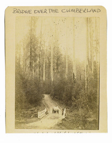 Marysville & District Historical Society
Photograph (Item) - Black and white photograph, Bridge Over The Cumberland, c1900
... ARMSTRONG OAM An early black and white photograph of a bridge over the Cumberland Creek near Marysville in Victoria. ...An early black and white photograph of a bridge over the Cumberland Creek near Marysville in Victoria.An early black and white photograph of a bridge over the Cumberland Creek near Marysville in Victoria. The Cumberland Creek is in the Cumberland Valley near Cambarville which was a timber town near Marysville. Cambarville is notable for its giant mountain ash (Eucalyptus regnans) trees within the Cumberland Memorial Scenic Reserve, and relics from former sawmills and gold mining. The Big Culvert is located nearby on the Marysville - Woods Point Road, which was historically part of the Yarra Track. Cambarville was established as a timber mill town in the 1940s. Timber mill owners A Cameron and FJ Barton named Cambarville. They established the mill to salvage timber from trees destroyed in the 1939 bushfires. Cambarville was impacted by the 2009 Black Saturday bushfires and any remaining structures were destroyed.ARMSTRONG COLLECTION 42 STATION STREET/ SANDRINGHAM 3191/ TEL. (03) 9521 5442/ IAN M.L. ARMSTRONG OAMcumberland creek, marysville, victoria, cumberland valley, cambarville, mountain ash, eucalyptus regnans, cumberland memorial reserve, the big culvert, marysville-wood's point road, yarra track, a cameron, fj barton, 2009 black saturday bushfires -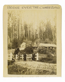
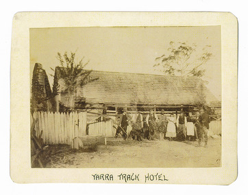 Marysville & District Historical Society
Photograph (Item) - Black and white photograph, Yarra Track Hotel, c1900
... Unable to ascertain both the location and name of hotel. yarra track healesville wood's point jordan goldfields victoria yarra river great divide reick black spur acheron valley marysville cumberland creek ARMSTRONG COLLECTION 42 STATION STREET/ SANDRINGHAM 3191/ TEL. (03) 9521 5442/ IAN M.L. ...An early black and white photograph of a hotel along the Yarra Track.An early black and white photograph of a hotel along the Yarra Track. The Yarra Track is the former name of the gold fields road from Healesville to the Woods Point and Jordan Goldfields, in Victoria, Australia. A direct route via the Yarra River and the Great Divide was discovered by Rieck in September 1862 and became known as the Yarra Track. Early in 1863, the Victorian Government decided to construct a 193-kilometre (120 mile) road along the route. Its original width varied between 4 and 6 metres (12 and 20 feet), and was designed to accommodate horse-drawn vehicles. The Track involved the climbing of the Black Spur, descent into the Acheron Valley, and then through Marysville to the Cumberland where it followed the existing route. Unable to ascertain both the location and name of hotel.ARMSTRONG COLLECTION 42 STATION STREET/ SANDRINGHAM 3191/ TEL. (03) 9521 5442/ IAN M.L. ARMSTRONG OAMyarra track, healesville, wood's point, jordan goldfields, victoria, yarra river, great divide, reick, black spur, acheron valley, marysville, cumberland creek -
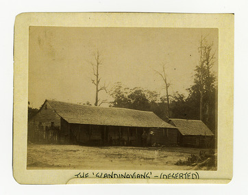
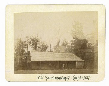 Marysville & District Historical Society
Photograph (Item) - Black and white photograph, The "Scandinavians' - (Deserted), c1900
... The Track involved the climbing of the Black Spur, descent into the Acheron Valley, and then through Marysville to the Cumberland where it followed the existing route. the scandinavians' yarra track healesville wood's point jordan goldfields victoria yarra river great divide reick black spur acheron valley marysville cumberland creek ARMSTRONG COLLECTION 42 STATION STREET/ SANDRINGHAM 3191/ TEL. (03) 9521 5442/ IAN M.L. ...An early black and white photograph of The Scandinavian's Hotel and Boarding House along the Yarra Track.An early black and white photograph of The Scandinavian's Hotel and Boarding House along the Yarra Track. The Yarra Track is the former name of the gold fields road from Healesville to the Woods Point and Jordan Goldfields, in Victoria, Australia. A direct route via the Yarra River and the Great Divide was discovered by Rieck in September 1862 and became known as the Yarra Track. Early in 1863, the Victorian Government decided to construct a 193-kilometre (120 mile) road along the route. Its original width varied between 4 and 6 metres (12 and 20 feet), and was designed to accommodate horse-drawn vehicles. The Track involved the climbing of the Black Spur, descent into the Acheron Valley, and then through Marysville to the Cumberland where it followed the existing route.ARMSTRONG COLLECTION 42 STATION STREET/ SANDRINGHAM 3191/ TEL. (03) 9521 5442/ IAN M.L. ARMSTRONG OAMthe scandinavians', yarra track, healesville, wood's point, jordan goldfields, victoria, yarra river, great divide, reick, black spur, acheron valley, marysville, cumberland creek -
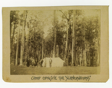 Marysville & District Historical Society
Photograph (Item) - Black and white photograph, Camp Opposite The "Scandinavians', c1900
... The Track involved the climbing of the Black Spur, descent into the Acheron Valley, and then through Marysville to the Cumberland where it followed the existing route. the scandinavians' yarra track healesville wood's point jordan goldfields victoria yarra river great divide reick black spur acheron valley marysville cumberland creek ARMSTRONG COLLECTION 42 STATION STREET/ SANDRINGHAM 3191/ TEL. (03) 9521 5442/ IAN M.L. ...An early black and white photograph of a camp which was opposite The Scandinavian's Hotel and Boarding House along the Yarra Track.An early black and white photograph of a camp which was opposite The Scandinavian's Hotel and Boarding House along the Yarra Track. The Yarra Track is the former name of the gold fields road from Healesville to the Woods Point and Jordan Goldfields, in Victoria, Australia. A direct route via the Yarra River and the Great Divide was discovered by Rieck in September 1862 and became known as the Yarra Track. Early in 1863, the Victorian Government decided to construct a 193-kilometre (120 mile) road along the route. Its original width varied between 4 and 6 metres (12 and 20 feet), and was designed to accommodate horse-drawn vehicles. The Track involved the climbing of the Black Spur, descent into the Acheron Valley, and then through Marysville to the Cumberland where it followed the existing route.ARMSTRONG COLLECTION 42 STATION STREET/ SANDRINGHAM 3191/ TEL. (03) 9521 5442/ IAN M.L. ARMSTRONG OAMthe scandinavians', yarra track, healesville, wood's point, jordan goldfields, victoria, yarra river, great divide, reick, black spur, acheron valley, marysville, cumberland creek -
 Marysville & District Historical Society
Ephemera (Item) - Information brochure, Artworkz Tourism, MARYSVILLE THINGS TO DO AROUND MARYSVILLE, 27-01-2018
... creek day area...beauty spot nature walk...gilbert gully nature walk...michaeldene track...cathedral range...the beeches walk...tree fern gully walk...crystal journey...marysville market...lake mountain ski resort...marysville golf club...marysville public outdoor swimming pool...buxton trout & salmon farm...keppel's lookout...jock's lookout...mount gordon...armstrong...An information brochure on things to do around Marysville in Victoria. marysville victoria australia information brochure gallipoli park lake gallipoli lake steavenson falls steavenson river bruno's art and sculpture garden fernshaw park buxton recreation reserve taggerty river areas anderson mill camping area cooks mill camping area neds gully camping area keppel creek day area beauty spot nature walk gilbert gully nature walk michaeldene track cathedral range the beeches walk tree fern gully walk crystal journey marysville market lake mountain ski resort marysville golf club marysville public outdoor swimming pool buxton trout & salmon farm keppel's lookout jock's lookout mount gordon armstrong lookout keppel falls phantom falls cora lynn falls meeting of the waters st ronan's well preiffer falls camberville historical township keppels hut the big culvert the big tree marysville historical society Disclaimer: The authors have taken care to ensure this/ publication is correct, though please be aware that/ errors and omissions do occur. ...An information brochure on things to do around Marysville in Victoria.An information brochure on things to do around Marysville in Victoria.Disclaimer: The authors have taken care to ensure this/ publication is correct, though please be aware that/ errors and omissions do occur.marysville, victoria, australia, information brochure, gallipoli park lake, gallipoli lake, steavenson falls, steavenson river, bruno's art and sculpture garden, fernshaw park, buxton recreation reserve, taggerty river areas, anderson mill camping area, cooks mill camping area, neds gully camping area, keppel creek day area, beauty spot nature walk, gilbert gully nature walk, michaeldene track, cathedral range, the beeches walk, tree fern gully walk, crystal journey, marysville market, lake mountain ski resort, marysville golf club, marysville public outdoor swimming pool, buxton trout & salmon farm, keppel's lookout, jock's lookout, mount gordon, armstrong lookout, keppel falls, phantom falls, cora lynn falls, meeting of the waters, st ronan's well, preiffer falls, camberville historical township, keppels hut, the big culvert, the big tree, marysville historical society -
 Eltham District Historical Society Inc
Binder, Eltham District History, Eltham Road Board, 1856-1871; Research by Keith Chappel, 1971-1974
... creek...nicholas rodda...nillumbik...norman mcphee...old caledonia gully...oliver gourlay...one tree hill...owen finnegan...panton hill...panton hill hotel...panton hill post office...panton hill school...parambool...patrick armstrong...Eltham District History, Eltham Road Board, 1856-1871 a. foley a. harkness a. mackie a. mcintyre a. von ziegler a.a. vivian a.d. kinninmont a.d. quadri a.h. grimshaw a.w. page aboriginal reserve aborigines abraham quarman abraham rooks abraham taylor adam goudie aenaes harrison agnes black agnes charlton agnes dalrymple ah chong ah cock ah hein ah lie ah sing albert lunson albert ness albert parker albert ramseyor alert hunt alex cameron alex eason alex mcandrew alexander crichton alexander donaldson alexander falconer alexander innes alexander james alexander mcdonald alexander miller alexander thompson alexander walker alexander white alfred armstrong alfred burgess alfred davey alfred deschamp alfred eddy alfred hinley alfred hooper alfred hubbard alfred lowman alfred smith alfred whelpton alice power allen heeps allwood amelia neuman amos taylor anderson andersons creek andrew brown andrew byrne andrew harkness andrew herbert andrew ross andrew smith angus mcdonald ann emmott ann mcphee ann odea ann plunkett ann snell ann tatty annie ashmore annie herbert annie stuart anthony beale anthony currie ants nest archibald mcphee arthur connor arthur lyttle arthur rooke arthur young arthurs creek arthurs creek school august ostling b.o. wallis barkers creek barr belton benjamin bain benjamin jenken benjamin lawford benjamin rice benjamin shaw benjamin smith benjamin wallis benjamin walton berry bismark hotel black calf gully black thursday boomers gully bridget bunker bridget hailes bridget kearse bruno hirt burns bushranger c. twiss c.h. bade caleb sherar caledonia caledonia diggings campbell hunter carl euman caroline davey catherine kennedy cathren brock cecilia farman chamberlain chapman charles caldwell charles campbell charles dale charles draper charles fowler charles green charles hawkins charles hempel charles hirt charles hirtson charles jefer charles jesse charles kerchevell charles lidgerwood charles morris charles peake charles prince charles rielly charles roberts charles rowand charles simms charles souter charles swan charles verso charles wells charles whelpton charles williams charles wingrove charles woodley charleys gully charlotte beltison charlotte goodwin ching ah hock christine brennan christine mckenzie christmas hills hotel christmas hills school christopher battaila christopher twiss chune grove church of england church of england school clarissa milton cleir hills colin amos constable quirke constable talty cornelius haley cornelius stewart cottles bridge councillors hotel cricket cucksons brewery d. nicholson d.w. morrissey dalry daniel charleston daniel harding daniel jepps daniel mccarthy daniel mckenzie daniel mcloughlin daniel oloughlin david boyd david christian david clark david creighton david rogers david rolfe david sharp david shawcross david smith david stevenson diamond accommodation store diamond reef mine dickson dixon bertram donald cameron donald mcmillan donaldson dougald mcphee dr barclay dugald mcphee dugald taylor duncan fraser duncan smith dungey e. hildebrand e. stichlins e.f. falkiner e.j. hughes e.m. garsed e.w. morrissey edith staff edmund clarke edmund cuckson edmund hall edmund picket edward bage edward beltison edward bunker edward ford edward hindley edward jackson edward jones edward kelly edward qualtrough edward staff edward tresain edward weller edward whelpton edward whilpson edwin biley edwin cartwright edwin cohen edwin deschamp edwin mcleish edwin rodda edwin smith effie rodda eliza bellamy eliza dawson eliza howell eliza nield eliza smith elizabeth cockshutt elizabeth eiles elizabeth fitch elizabeth gillespie elizabeth harris elizabeth herbert elizabeth hollow elizabeth le juge elizabeth plunkett elizabeth whelpton ellen hurst ellen kearse ellen quarman ellen sweeney ellen white ellis eltham cemetery eltham hotel eltham lower park eltham market eltham police station eltham pound eltham quarry eltham racecourse eltham roads board eltham school emile hude emily anderson emily blamire emily coutie emma smith emma taylor ephraim wyett ernest baillie ernest henrick ernest steer esther porter ethel baillie evan jones evelyn hotel evelyn observer ewen cameron ewen jones f. chrimes f. grundel f.e. falkiner f.r. howard fanny benson fanny white felix hude felix noisette ferdinand ramseyer flora vale florence hurst fogarty forbes mackenzie fords creek frances kearse francis baker francis hales francis raselli francis steer frank eiles frank rogerson frank tanner fraser fred hurst frederick falkiner frederick hurst frederick muller frederick nink frederick walker frederick wharington friedrich muller fryers gully furphy g. donaldson g. houghton g. turnbull geanetta hude george assender george bear george beare george benson george bird george boston george brain george brandt george burley george buswell george coutie george eiles george ewings george ford george godber george goodman george gray george griffiths george hall george herbert george horn george kirk george langhorne george mann george mclelland george mosely george neumayer george orchard george parish george porter george purcell george ralph george reid george rocke george rogers george rolfe george stebbing george stebbings george stebbins george switzer george symons george thompson georgina hilton glenda moriss glengloy gold goulstone greensborough police station gulf station h. jennings h. mann h.h. farquason hannah sunderland happy valley harkness harold scarce harriet hunt harriet smith harry hollow hazel glen healesville heinrich hirt helena peters henrietta hill henry arthur henry ashmore henry austin henry brown henry dendy henry dineen henry fowler henry gardner henry green henry griffin henry hart henry hirst henry hirt henry hopkinson henry hude henry hurst henry inch henry jones henry mills henry scarce henry st paul henry stevens henry stooke henry thomson henry vogt henry wallace henry wilson herbert rodda herman henrick hermann lampe hermann steinmann hester staff hitchill holbert honoree hude hotel de france hugh mccann humphrey peers humphrey spicer hurstbridge hurstbridge general store i.h. clarke ida adelskold ignatz kinzel ira pimm irene donaldson isaac briggs isaac hickson isaac hill isaac kerr isaac varby isaac williams isabella donaldson isabelle herbert j. dungate j. eccleston j. harkness j. hartley j. hude j. irvine j. jones j. manduell j. mason j. mcdonald j. mcnamara j. nichenson j. renahen j. scott j. seymour j.a. goold j.a. panton j.c. hughes j.d. thompson j.f. hughes j.f. johnstone j.g. walter j.h. taylor j.p. morris jack ewart jacob belsham jacob goldstein jacob morast jam loon james alexander james anderson james andrew james andrews james baines james batchelor james bond james bradford james brennan james brock james brown james brunning james buchanan james cockburn james cowan james dalrymple james donaldson james duckworth james goodwin james harding james harrison james hartley james hawkins james hewish james holinger james hughes james inglis james jamieson james johnson james johnston james kaye james kew james lindsay james lindsey james lynan james macpherson james mann james martley james mayger james mccutcheon james mcmahon james mcpherson james mess james miller james mitton james morton james murdoch james murdock james nickinson james orford james purcell james qualtrough james rudall james simpson james smith james spence james stonachan james stuart james suman james surman james sutherland james thompson james thomson james walker james walters james watts jane cleave jane donaldson jane mess jane sadler jane shaw jane thomson janefield jean borelli jeanette hudi jeanne hude johann muller john ainsworth john andrew john baillie john barr john beale john bell john bellin john blake john blyth john brock john brown john byers john cameron john candler john carter john cobbock john cockshank john cockshutt john coleman john connell john crozier john darroch john dennis john donaldson john elsworthy john fenton john fitch john gardner john gast john graham john grimshaw john haines john haley john harper john harris john hassall john hayes john heales john herbert john holland john holman john hood john horner john horton john hughes john jardine john johns john johnston john jones john kearse john kilpatrick john knell john lawrey john macadam john mandell john manduell john marker john mccoll john mccolly john mcdonald john mcintyre john mckimmie john mcnamara john mitchell john moore john morgan john muller john murray john pearson john peterson john petty john pullen john quinn john rawlings john ryder john sabelberg john scott john semar john serman john seymour john shawcross john smith john staff john steer john stephens john sweeney john thompson john thomson john trahy john walker john weller john wells john williams john williamson john yates john yeoman john young johnn mcdonnell joseph bull joseph burns joseph caldwell joseph caudwell joseph coutie joseph elliott joseph emmott joseph fayver joseph furphy joseph hall joseph hibbert joseph hilton joseph johns joseph lithgow joseph panton joseph rodda joseph sands joseph sanson joseph schubert joseph scott joseph shaw joseph smith joseph spedder joseph stevenson joseph verco joseph wilson josiah hollis josiah hullis josiah thomas judith furphy julie williams junction hotel kangaroo forest kangaroo ground kangaroo ground cemetery kangaroo ground general store kangaroo ground hotel kangaroo ground police station kangaroo ground post office kangaroo ground school kate bolger kath scarce katherine kearse kidd kinglake kinglake hotel kingstown l. storey lan quan lang latimour laura henrick laurence paterson leon berlioz levinia henrick lillian gillan linton little eltham long gully louis henrick louis le juge louis smith louisa steinmann louise miller lower plenty bridge hotel lucy tidell lydia qualtrough m.j. careton m.s. adams macrudden maggs mail coach maplestone margaret graham margaret hollins margaret kearse margaret kennedy margaret kinrade margaret lynch margaret mcbirney margaret steinmann marguerite borelli maria reilly maria st paul maria trew marian trew marianne miller marie wright marion hillier mark bunker martha herbert martin brennan mary alexander mary beltison mary bradford mary bridgman mary brock mary bull mary eiles mary hopkinson mary kearse mary lean mary mcinerney mary miller mary parmington mary pearson mary pickles mary robertson mary rodda mary ross mary smith mary surman mary weller matilda jordan matilda mcmillan matthias watson mawson mechanics institute michael callanan michael fenton michael kearse michael mctyne michael merritt michael oday michael odea midgley hall mills minnie watts miss bellon morgans gully mount joy mr donnan mr omeare mr page mrs greenaway mrs havard mrs hude mrs morris muller murrays bridge n.d. whyte ned kelly new caledonia creek nicholas rodda nillumbik norman mcphee old caledonia gully oliver gourlay one tree hill owen finnegan panton hill panton hill hotel panton hill post office panton hill school parambool patrick armstrong patrick bourke patrick burke patrick callaghan patrick green patrick harrington patrick kearse patrick lynch patrick mcintyre patrick o'callaghan patrick rodgers patrick sheahan peach grove perinella bull perry peter carrucan peter flyn peter ford peter lawlor peter patterson peter snodgrass peter watson philip korfman phillip gakden phillip kaufman phillip korfman pierce brennan pierce power poo long pound bend pretty hill queenstown queenstown cemetery queenstown police station queenstown school r. mackie r.a. davidson rebecca noisette rebecca weller reefers hotel research research gully research gully hotel research hotel research school rev dobinson rhoda coutie richard brook richard capper richard dunstan richard goulding richard heales richard lane richard matthews richard rodda richard searle richard smith richard wallis richard warren richard woolcott robert alice robert bourke robert burke robert charlton robert clarke robert cunningham robert dugdale robert grant robert hall robert harris robert hempel robert hill robert hurst robert lowman robert mcadam robert mckee robert nink robert norman robert pontessey robert sharp robert smith robert steel robert stevenson robert strong robert surnam robert wood robina joyce rogerson roman catholic church rossiter rudolph muller ruth mess ruth sadler ruth stevenson s. smith s. stewart salters rush sam deacon samuel bird samuel brace samuel cameron samuel candler samuel cole samuel cracknell samuel dagley samuel flier samuel furphy samuel merriman samuel moseley samuel mosley samuel smith sarah howard sarah moseley sarah raston sarah walters second watery gully school self shin hun simon armstrong smiths gully smiths gully mechanics institute smiths gully school sophia greenaway spanish gully st andrews st andrews hotel st helena stack stanley smith stephen gonnet stephenson turner stephensons bridge steven anderson stevensons corner sumner susan dickson susan street susan walke sutherland t. davidson t. mclaughlin t. symons t.a. aldwell t.b. drummond t.b. henderson t.e. johnston t.h. subelly tarrawarra theis theodore sabelberg theresa lynch thomas anderson thomas armstrong thomas baillie thomas batt thomas bell thomas benson thomas bibbs thomas boardman thomas bradford thomas bull thomas cattery thomas cochrane thomas cook thomas cottle thomas cousins thomas downward thomas edwards thomas evans thomas grierson thomas haines thomas harmer thomas hunniford thomas huntford thomas hurry thomas jardine thomas jones thomas kearse thomas kennedy thomas marland thomas martin thomas mcinerney thomas morrison thomas mundy thomas murphy thomas murray thomas peacock thomas plunkett thomas postlethwaite thomas prior thomas qualtrough thomas smith thomas stone thomas sunderland thomas swatling thomas sweeney thomas symons thomas walke thomas wall thomas wright thomas young tim shaw toll gate tom collins tommys hut true upper diamond creek upper diamond creek school view hill virtue hall w. cockayne w. craig w. foster w. marriott w. ridley w. trenoweth w.a. page w.b. andrew w.b. burnley w.b. phillips w.c. shortt w.w. herbert walter barlow walter hillier walter joyce walter knell walter mckimmie walter mcnicoll walter thomson walter wippell warburton carr warrandyte warrens hotel watery gully watsons creek watsons creek hotel wattle glen school wellers hotel weymss donaldson whipstick gully white cloud wild dog creek wild dog gully wiliam albert william aitken william albert william anderson william andrews william barr william barrow william bell william bond william bowden william bremmer william brewer william bridgman william burnley william buswell william cant william clarke william cleave william crozier william dawson william dodging william ellis william finn william fitzgibbon william ford william foster william garland william ghosley william golding william goodwin william graham william gray william grimshaw william hall william harding william herbert william hoilett william hopkinson william howitt william howlett william hubbard william hunt william inglis william jarrold william joyce william kidd william kilpatrick william kommer william lodge william mclaughlin william mcmurray william mitton william moore william mosley william murphy william nicholson william normage william norman william nuttall william phillips william quarman william ronald william sadler william scott william seaville william sharp william smith william spicer william taylor william thomson william tobin william underwood william walsh william walshe william walters william watkins william west william wilmot william wilson william wolverston william woods wolfe woodley yarra bank yow yow creek a. brewer a. easson a. edwards a. melville a.m. ross a.r. larrimour aborigine reserve advertisements agricultural district alan bernhard horsley albert frederick charles glover albert h price albert h.c. price albert henry charles price alex easson alexander campbell alexander melville alexander thomas haley alexander thomson alfred j. lowman alice may peake alie haley alistair knox alistair samuel knox allandale road allendale road allwood run andrew andrew mckay anton william brinkkotter archibald brown argus arthur chichester allen arthur edwin cracknell arthur john braid arthur robert traynor atlas of australia 1886 b. lawford b. mess barry thale houston basil y hall basil yaldwyn hall bell street benjamin baxter benjamin bowater benjamin thomas taylor benjaomin o. wallis bible street billis bolton street brewery brisbane street buckingham bushrangers c. brown c. carroll c. hirt c.s. haley c.s. wingrove c.t. harris caledonia run cam cattle charis meta alexander pelling charles brown charles ellis charles hicks bath charles newman clara gonnet claude bryan gibbs clifford henry goulding seear coleraine colin t. bell collectors collingwood commissioner airey coplin thomas bell cornelius john stewart cornelius sharp haley cornelius sharpe haley county of evelyn culla hill cutto hill d. ryan daily news newspaper dalton street daniel jepp derek cecil o'beirne diamond creek diamond creek post office diamond creek railway station diamond creek run diamond creek station diamond creek township divisions doctor donald alfred neil donald charles maling donald ingersole donald kennedy douglas anderson e. cameron e. falkiner e. stooke e.t. peers edward dumaresq edward heller edward james edward wilson edwin stooke elections electoral districts electoral roll electrified railway eltham eltham district description eltham district history eltham district road board eltham post office eltham railway station eltham road district eltham road district board eltham shire council eltham shire councillors eltham shire history eltham town common eltham village eltham-hurstbridge railway ely street eric dudley butler eric nichol staff eric percival harmer ernest james andrews eve may edwards evelyn and mornington division evelyn division everard albert hale ewn hugh cameron f. stone f.d. wickham flour mill fountain of friendship hotel francis bradley francis joseph favier francis regiereals(?) ...Eltham District History, Eltham Road Board, 1856-1871Two binders containing 486 A4 pages (photocopied) of mostly handwritten notes from research undertaken of Public Office Records of Victoria various holdings. Some photocopies from source reference books. Includes 20 page subject index (handwritten) at front and 5 pages of notes and sources at rear and a photocopy of short biography of Keith Chappel.a. foley, a. harkness, a. mackie, a. mcintyre, a. von ziegler, a.a. vivian, a.d. kinninmont, a.d. quadri, a.h. grimshaw, a.w. page, aboriginal reserve, aborigines, abraham quarman, abraham rooks, abraham taylor, adam goudie, aenaes harrison, agnes black, agnes charlton, agnes dalrymple, ah chong, ah cock, ah hein, ah lie, ah sing, albert lunson, albert ness, albert parker, albert ramseyor, alert hunt, alex cameron, alex eason, alex mcandrew, alexander crichton, alexander donaldson, alexander falconer, alexander innes, alexander james, alexander mcdonald, alexander miller, alexander thompson, alexander walker, alexander white, alfred armstrong, alfred burgess, alfred davey, alfred deschamp, alfred eddy, alfred hinley, alfred hooper, alfred hubbard, alfred lowman, alfred smith, alfred whelpton, alice power, allen heeps, allwood, amelia neuman, amos taylor, anderson, andersons creek, andrew brown, andrew byrne, andrew harkness, andrew herbert, andrew ross, andrew smith, angus mcdonald, ann emmott, ann mcphee, ann odea, ann plunkett, ann snell, ann tatty, annie ashmore, annie herbert, annie stuart, anthony beale, anthony currie, ants nest, archibald mcphee, arthur connor, arthur lyttle, arthur rooke, arthur young, arthurs creek, arthurs creek school, august ostling, b.o. wallis, barkers creek, barr, belton, benjamin bain, benjamin jenken, benjamin lawford, benjamin rice, benjamin shaw, benjamin smith, benjamin wallis, benjamin walton, berry, bismark hotel, black calf gully, black thursday, boomers gully, bridget bunker, bridget hailes, bridget kearse, bruno hirt, burns, bushranger, c. twiss, c.h. bade, caleb sherar, caledonia, caledonia diggings, campbell hunter, carl euman, caroline davey, catherine kennedy, cathren brock, cecilia farman, chamberlain, chapman, charles caldwell, charles campbell, charles dale, charles draper, charles fowler, charles green, charles hawkins, charles hempel, charles hirt, charles hirtson, charles jefer, charles jesse, charles kerchevell, charles lidgerwood, charles morris, charles peake, charles prince, charles rielly, charles roberts, charles rowand, charles simms, charles souter, charles swan, charles verso, charles wells, charles whelpton, charles williams, charles wingrove, charles woodley, charleys gully, charlotte beltison, charlotte goodwin, ching ah hock, christine brennan, christine mckenzie, christmas hills hotel, christmas hills school, christopher battaila, christopher twiss, chune grove, church of england, church of england school, clarissa milton, cleir hills, colin amos, constable quirke, constable talty, cornelius haley, cornelius stewart, cottles bridge, councillors hotel, cricket, cucksons brewery, d. nicholson, d.w. morrissey, dalry, daniel charleston, daniel harding, daniel jepps, daniel mccarthy, daniel mckenzie, daniel mcloughlin, daniel oloughlin, david boyd, david christian, david clark, david creighton, david rogers, david rolfe, david sharp, david shawcross, david smith, david stevenson, diamond accommodation store, diamond reef mine, dickson, dixon bertram, donald cameron, donald mcmillan, donaldson, dougald mcphee, dr barclay, dugald mcphee, dugald taylor, duncan fraser, duncan smith, dungey, e. hildebrand, e. stichlins, e.f. falkiner, e.j. hughes, e.m. garsed, e.w. morrissey, edith staff, edmund clarke, edmund cuckson, edmund hall, edmund picket, edward bage, edward beltison, edward bunker, edward ford, edward hindley, edward jackson, edward jones, edward kelly, edward qualtrough, edward staff, edward tresain, edward weller, edward whelpton, edward whilpson, edwin biley, edwin cartwright, edwin cohen, edwin deschamp, edwin mcleish, edwin rodda, edwin smith, effie rodda, eliza bellamy, eliza dawson, eliza howell, eliza nield, eliza smith, elizabeth cockshutt, elizabeth eiles, elizabeth fitch, elizabeth gillespie, elizabeth harris, elizabeth herbert, elizabeth hollow, elizabeth le juge, elizabeth plunkett, elizabeth whelpton, ellen hurst, ellen kearse, ellen quarman, ellen sweeney, ellen white, ellis, eltham cemetery, eltham hotel, eltham lower park, eltham market, eltham police station, eltham pound, eltham quarry, eltham racecourse, eltham roads board, eltham school, emile hude, emily anderson, emily blamire, emily coutie, emma smith, emma taylor, ephraim wyett, ernest baillie, ernest henrick, ernest steer, esther porter, ethel baillie, evan jones, evelyn hotel, evelyn observer, ewen cameron, ewen jones, f. chrimes, f. grundel, f.e. falkiner, f.r. howard, fanny benson, fanny white, felix hude, felix noisette, ferdinand ramseyer, flora vale, florence hurst, fogarty, forbes mackenzie, fords creek, frances kearse, francis baker, francis hales, francis raselli, francis steer, frank eiles, frank rogerson, frank tanner, fraser, fred hurst, frederick falkiner, frederick hurst, frederick muller, frederick nink, frederick walker, frederick wharington, friedrich muller, fryers gully, furphy, g. donaldson, g. houghton, g. turnbull, geanetta hude, george assender, george bear, george beare, george benson, george bird, george boston, george brain, george brandt, george burley, george buswell, george coutie, george eiles, george ewings, george ford, george godber, george goodman, george gray, george griffiths, george hall, george herbert, george horn, george kirk, george langhorne, george mann, george mclelland, george mosely, george neumayer, george orchard, george parish, george porter, george purcell, george ralph, george reid, george rocke, george rogers, george rolfe, george stebbing, george stebbings, george stebbins, george switzer, george symons, george thompson, georgina hilton, glenda moriss, glengloy, gold, goulstone, greensborough police station, gulf station, h. jennings, h. mann, h.h. farquason, hannah sunderland, happy valley, harkness, harold scarce, harriet hunt, harriet smith, harry hollow, hazel glen, healesville, heinrich hirt, helena peters, henrietta hill, henry arthur, henry ashmore, henry austin, henry brown, henry dendy, henry dineen, henry fowler, henry gardner, henry green, henry griffin, henry hart, henry hirst, henry hirt, henry hopkinson, henry hude, henry hurst, henry inch, henry jones, henry mills, henry scarce, henry st paul, henry stevens, henry stooke, henry thomson, henry vogt, henry wallace, henry wilson, herbert rodda, herman henrick, hermann lampe, hermann steinmann, hester staff, hitchill, holbert, honoree hude, hotel de france, hugh mccann, humphrey peers, humphrey spicer, hurstbridge, hurstbridge general store, i.h. clarke, ida adelskold, ignatz kinzel, ira pimm, irene donaldson, isaac briggs, isaac hickson, isaac hill, isaac kerr, isaac varby, isaac williams, isabella donaldson, isabelle herbert, j. dungate, j. eccleston, j. harkness, j. hartley, j. hude, j. irvine, j. jones, j. manduell, j. mason, j. mcdonald, j. mcnamara, j. nichenson, j. renahen, j. scott, j. seymour, j.a. goold, j.a. panton, j.c. hughes, j.d. thompson, j.f. hughes, j.f. johnstone, j.g. walter, j.h. taylor, j.p. morris, jack ewart, jacob belsham, jacob goldstein, jacob morast, jam loon, james alexander, james anderson, james andrew, james andrews, james baines, james batchelor, james bond, james bradford, james brennan, james brock, james brown, james brunning, james buchanan, james cockburn, james cowan, james dalrymple, james donaldson, james duckworth, james goodwin, james harding, james harrison, james hartley, james hawkins, james hewish, james holinger, james hughes, james inglis, james jamieson, james johnson, james johnston, james kaye, james kew, james lindsay, james lindsey, james lynan, james macpherson, james mann, james martley, james mayger, james mccutcheon, james mcmahon, james mcpherson, james mess, james miller, james mitton, james morton, james murdoch, james murdock, james nickinson, james orford, james purcell, james qualtrough, james rudall, james simpson, james smith, james spence, james stonachan, james stuart, james suman, james surman, james sutherland, james thompson, james thomson, james walker, james walters, james watts, jane cleave, jane donaldson, jane mess, jane sadler, jane shaw, jane thomson, janefield, jean borelli, jeanette hudi, jeanne hude, johann muller, john ainsworth, john andrew, john baillie, john barr, john beale, john bell, john bellin, john blake, john blyth, john brock, john brown, john byers, john cameron, john candler, john carter, john cobbock, john cockshank, john cockshutt, john coleman, john connell, john crozier, john darroch, john dennis, john donaldson, john elsworthy, john fenton, john fitch, john gardner, john gast, john graham, john grimshaw, john haines, john haley, john harper, john harris, john hassall, john hayes, john heales, john herbert, john holland, john holman, john hood, john horner, john horton, john hughes, john jardine, john johns, john johnston, john jones, john kearse, john kilpatrick, john knell, john lawrey, john macadam, john mandell, john manduell, john marker, john mccoll, john mccolly, john mcdonald, john mcintyre, john mckimmie, john mcnamara, john mitchell, john moore, john morgan, john muller, john murray, john pearson, john peterson, john petty, john pullen, john quinn, john rawlings, john ryder, john sabelberg, john scott, john semar, john serman, john seymour, john shawcross, john smith, john staff, john steer, john stephens, john sweeney, john thompson, john thomson, john trahy, john walker, john weller, john wells, john williams, john williamson, john yates, john yeoman, john young, johnn mcdonnell, joseph bull, joseph burns, joseph caldwell, joseph caudwell, joseph coutie, joseph elliott, joseph emmott, joseph fayver, joseph furphy, joseph hall, joseph hibbert, joseph hilton, joseph johns, joseph lithgow, joseph panton, joseph rodda, joseph sands, joseph sanson, joseph schubert, joseph scott, joseph shaw, joseph smith, joseph spedder, joseph stevenson, joseph verco, joseph wilson, josiah hollis, josiah hullis, josiah thomas, judith furphy, julie williams, junction hotel, kangaroo forest, kangaroo ground, kangaroo ground cemetery, kangaroo ground general store, kangaroo ground hotel, kangaroo ground police station, kangaroo ground post office, kangaroo ground school, kate bolger, kath scarce, katherine kearse, kidd, kinglake, kinglake hotel, kingstown, l. storey, lan quan, lang, latimour, laura henrick, laurence paterson, leon berlioz, levinia henrick, lillian gillan, linton, little eltham, long gully, louis henrick, louis le juge, louis smith, louisa steinmann, louise miller, lower plenty bridge hotel, lucy tidell, lydia qualtrough, m.j. careton, m.s. adams, macrudden, maggs, mail coach, maplestone, margaret graham, margaret hollins, margaret kearse, margaret kennedy, margaret kinrade, margaret lynch, margaret mcbirney, margaret steinmann, marguerite borelli, maria reilly, maria st paul, maria trew, marian trew, marianne miller, marie wright, marion hillier, mark bunker, martha herbert, martin brennan, mary alexander, mary beltison, mary bradford, mary bridgman, mary brock, mary bull, mary eiles, mary hopkinson, mary kearse, mary lean, mary mcinerney, mary miller, mary parmington, mary pearson, mary pickles, mary robertson, mary rodda, mary ross, mary smith, mary surman, mary weller, matilda jordan, matilda mcmillan, matthias watson, mawson, mechanics institute, michael callanan, michael fenton, michael kearse, michael mctyne, michael merritt, michael oday, michael odea, midgley hall, mills, minnie watts, miss bellon, morgans gully, mount joy, mr donnan, mr omeare, mr page, mrs greenaway, mrs havard, mrs hude, mrs morris, muller, murrays bridge, n.d. whyte, ned kelly, new caledonia creek, nicholas rodda, nillumbik, norman mcphee, old caledonia gully, oliver gourlay, one tree hill, owen finnegan, panton hill, panton hill hotel, panton hill post office, panton hill school, parambool, patrick armstrong, patrick bourke, patrick burke, patrick callaghan, patrick green, patrick harrington, patrick kearse, patrick lynch, patrick mcintyre, patrick o'callaghan, patrick rodgers, patrick sheahan, peach grove, perinella bull, perry, peter carrucan, peter flyn, peter ford, peter lawlor, peter patterson, peter snodgrass, peter watson, philip korfman, phillip gakden, phillip kaufman, phillip korfman, pierce brennan, pierce power, poo long, pound bend, pretty hill, queenstown, queenstown cemetery, queenstown police station, queenstown school, r. mackie, r.a. davidson, rebecca noisette, rebecca weller, reefers hotel, research, research gully, research gully hotel, research hotel, research school, rev dobinson, rhoda coutie, richard brook, richard capper, richard dunstan, richard goulding, richard heales, richard lane, richard matthews, richard rodda, richard searle, richard smith, richard wallis, richard warren, richard woolcott, robert alice, robert bourke, robert burke, robert charlton, robert clarke, robert cunningham, robert dugdale, robert grant, robert hall, robert harris, robert hempel, robert hill, robert hurst, robert lowman, robert mcadam, robert mckee, robert nink, robert norman, robert pontessey, robert sharp, robert smith, robert steel, robert stevenson, robert strong, robert surnam, robert wood, robina joyce, rogerson, roman catholic church, rossiter, rudolph muller, ruth mess, ruth sadler, ruth stevenson, s. smith, s. stewart, salters rush, sam deacon, samuel bird, samuel brace, samuel cameron, samuel candler, samuel cole, samuel cracknell, samuel dagley, samuel flier, samuel furphy, samuel merriman, samuel moseley, samuel mosley, samuel smith, sarah howard, sarah moseley, sarah raston, sarah walters, second watery gully school, self, shin hun, simon armstrong, smiths gully, smiths gully mechanics institute, smiths gully school, sophia greenaway, spanish gully, st andrews, st andrews hotel, st helena, stack, stanley smith, stephen gonnet, stephenson turner, stephensons bridge, steven anderson, stevensons corner, sumner, susan dickson, susan street, susan walke, sutherland, t. davidson, t. mclaughlin, t. symons, t.a. aldwell, t.b. drummond, t.b. henderson, t.e. johnston, t.h. subelly, tarrawarra, theis, theodore sabelberg, theresa lynch, thomas anderson, thomas armstrong, thomas baillie, thomas batt, thomas bell, thomas benson, thomas bibbs, thomas boardman, thomas bradford, thomas bull, thomas cattery, thomas cochrane, thomas cook, thomas cottle, thomas cousins, thomas downward, thomas edwards, thomas evans, thomas grierson, thomas haines, thomas harmer, thomas hunniford, thomas huntford, thomas hurry, thomas jardine, thomas jones, thomas kearse, thomas kennedy, thomas marland, thomas martin, thomas mcinerney, thomas morrison, thomas mundy, thomas murphy, thomas murray, thomas peacock, thomas plunkett, thomas postlethwaite, thomas prior, thomas qualtrough, thomas smith, thomas stone, thomas sunderland, thomas swatling, thomas sweeney, thomas symons, thomas walke, thomas wall, thomas wright, thomas young, tim shaw, toll gate, tom collins, tommys hut, true, upper diamond creek, upper diamond creek school, view hill, virtue hall, w. cockayne, w. craig, w. foster, w. marriott, w. ridley, w. trenoweth, w.a. page, w.b. andrew, w.b. burnley, w.b. phillips, w.c. shortt, w.w. herbert, walter barlow, walter hillier, walter joyce, walter knell, walter mckimmie, walter mcnicoll, walter thomson, walter wippell, warburton carr, warrandyte, warrens hotel, watery gully, watsons creek, watsons creek hotel, wattle glen school, wellers hotel, weymss donaldson, whipstick gully, white cloud, wild dog creek, wild dog gully, wiliam albert, william aitken, william albert, william anderson, william andrews, william barr, william barrow, william bell, william bond, william bowden, william bremmer, william brewer, william bridgman, william burnley, william buswell, william cant, william clarke, william cleave, william crozier, william dawson, william dodging, william ellis, william finn, william fitzgibbon, william ford, william foster, william garland, william ghosley, william golding, william goodwin, william graham, william gray, william grimshaw, william hall, william harding, william herbert, william hoilett, william hopkinson, william howitt, william howlett, william hubbard, william hunt, william inglis, william jarrold, william joyce, william kidd, william kilpatrick, william kommer, william lodge, william mclaughlin, william mcmurray, william mitton, william moore, william mosley, william murphy, william nicholson, william normage, william norman, william nuttall, william phillips, william quarman, william ronald, william sadler, william scott, william seaville, william sharp, william smith, william spicer, william taylor, william thomson, william tobin, william underwood, william walsh, william walshe, william walters, william watkins, william west, william wilmot, william wilson, william wolverston, william woods, wolfe, woodley, yarra bank, yow yow creek, a. brewer, a. easson, a. edwards, a. melville, a.m. ross, a.r. larrimour, aborigine reserve, advertisements, agricultural district, alan bernhard horsley, albert frederick charles glover, albert h price, albert h.c. price, albert henry charles price, alex easson, alexander campbell, alexander melville, alexander thomas haley, alexander thomson, alfred j. lowman, alice may peake, alie haley, alistair knox, alistair samuel knox, allandale road, allendale road, allwood run, andrew, andrew mckay, anton william brinkkotter, archibald brown, argus, arthur chichester allen, arthur edwin cracknell, arthur john braid, arthur robert traynor, atlas of australia 1886, b. lawford, b. mess, barry thale houston, basil y hall, basil yaldwyn hall, bell street, benjamin baxter, benjamin bowater, benjamin thomas taylor, benjaomin o. wallis, bible street, billis, bolton street, brewery, brisbane street, buckingham, bushrangers, c. brown, c. carroll, c. hirt, c.s. haley, c.s. wingrove, c.t. harris, caledonia run, cam, cattle, charis meta alexander pelling, charles brown, charles ellis, charles hicks bath, charles newman, clara gonnet, claude bryan gibbs, clifford henry goulding seear, coleraine, colin t. bell, collectors, collingwood, commissioner airey, coplin thomas bell, cornelius john stewart, cornelius sharp haley, cornelius sharpe haley, county of evelyn, culla hill, cutto hill, d. ryan, daily news newspaper, dalton street, daniel jepp, derek cecil o'beirne, diamond creek, diamond creek post office, diamond creek railway station, diamond creek run, diamond creek station, diamond creek township, divisions, doctor, donald alfred neil, donald charles maling, donald ingersole, donald kennedy, douglas anderson, e. cameron, e. falkiner, e. stooke, e.t. peers, edward dumaresq, edward heller, edward james, edward wilson, edwin stooke, elections, electoral districts, electoral roll, electrified railway, eltham, eltham district description, eltham district history, eltham district road board, eltham post office, eltham railway station, eltham road district, eltham road district board, eltham shire council, eltham shire councillors, eltham shire history, eltham town common, eltham village, eltham-hurstbridge railway, ely street, eric dudley butler, eric nichol staff, eric percival harmer, ernest james andrews, eve may edwards, evelyn and mornington division, evelyn division, everard albert hale, ewn hugh cameron, f. stone, f.d. wickham, flour mill, fountain of friendship hotel, francis bradley, francis joseph favier, francis regiereals(?), francis watson rosier, frank haley, frank wayne maas, franklin william nankervis, frederick charles barrett, frederick edward falkiner, frederick eldred griffith, frederick filed durham, frederick gration, frederick kirk gration, frederick vincent squire, fredrick ninck, g. drabble, g. haley, g. hodgkins, g. lee, g. thomas, g. thomson, g.d. boursiquot, g.f. belcher, garden hill, geoffrey charles dreverman, geology, george d'arley boursiquot, george ellis parker, george fletcher, george frederick belcher, george haley, george hirt, george louie cresp, george love, george robertson, george turnbull, george wise, godalmin street, gold mining, goodman, gordon melville, government gazette, graham lindsay bride, grazing, greenhill, greensborough, grierson, gun maker, h. g. james, h. stooke, h. taylor, h.g. jhones, h.t. beams, harold edward bartlett, heatherleigh, heidelberg, helen louise wells, henry creswell, henry gilbert jones, henry holloway, henry peers, herbert eric rundle, herbert hewitt, herbert rutter, hoddle, holiday resort, horace hilton, house of assembly, hugh larimour, hurst, i. barrow, i. rooks, ian g smedley, ian gordon smedley, industry, isaac rooks, isidore t. wilmor, j. alison, j. brown, j. cameron, j. carfrae & co., j. ferguson, j. frank, j. garthwaite, j. greaves, j. greitzner, j. irish, j. lindsay, j. murray, j. o'brien, j. stevenson, j. wilson, j.b. phipps, j.b. rodda, j.f. imley, j.g. foxton, j.g. fraser, j.h.f. hawke, j.k. zahn, j.m. holloway, j.p. imley, jack cato, jack clendinnen gill, jacob belcham, jacob greitzner, jakeb greitzner, james bailey, james cox, james d mealy, james darley mealy, james frank, james frederick mackay, james graham, james johnstone, james kay bryce, james mclaren, james murray, james oliver white, james pearson imley, james pearsons imley, james rosier, james ryan, jane thompson, jersey, johann karl zahn, john a porter, john alexander hampton lewis, john alison, john b. wilson, john barter bennett, john blackmore phipps, john blakemore phipps, john carfrae, john dane, john g. foxton, john gerald searle, john greaves, john green foxton, john greenlaw foxton, john henry sabelberg, john johnstone, john lee smith, john lindsay, john lindsay beale, john mann, john mason, john pape, john porter, john samuel lithgow, john stevenson, john verran mcconnell, john wilson, jonathan scott, joseph anderson panton, joseph bromley shallard, joseph garthwaite, joseph smedley, joseph walter henry bradbury, josiah morris holloway, k.e. dunstan, m kinglake, keelbundora, kenneth chareles crompton, kenneth donald macmillan, kenneth frederick hines, kenyon, kerby street, kinglake school, krelbundora, l. jenyns, l.m. bill, lancefield, land act 1862, land act 1865, land act 1869, land alienation, land settlement, legislative council, leopold kershaw lawry, leslie christopher docksey, leslie edward clarke, little eltham school, m. o'shea, m.h. fitzpatrick, mail run, mail service, main road, map, margaret moody, martin fogarty, mary leak, maxwell alexander spence, medical practitioner, michael o'shea, miss haley, moira, morang, mr. ford, mrs galbraith, n. gillies, n. rodda, name, names, neil stewart roberts, norman ernest charles williams, opening, orchard district, p. ryan, p.a.c o'farrell, p.p. cotter, parish of nillumbik, parish of nillumbik 1856, patrick costello, patrick turnbull, percy downer, peter andrew charles o'farrell, peter fair, peter graham, petr lawlor, phillip cumming, photographer, plenty river, polling place, polling places, porter street, portrait, post office, post office directory 1868, princes bridge, proclamation, r. boston, r. hepburn, r. lane, r. wadeson, r.d. mess, r.s.h. moody, radley (rodney) douglas quin, rag mill, railway lines, raymond clive duncan, registrar, research state school no. 2959, reserve for aborigines, reynolds road, richard jones and co, richard robert woolcott, river plenty, robert alan bell, robert benn (ship), robert cadden, robert cunningham white, robert david taylor, robert hepburn, robert kenneth marshall, robert miller, robert reid, robert stewart hull moody, robinia joyce, rodda family, rosemount, rupert norman maskell, ryans road, s. evans, s. wekey, samuel evans, samuel phillips, samuel ramsden, samuel w. scott, searle, shire of diamond valley, sigismund wekey, sly grog seller, sources, south province, south yarra, st kilda, stanley simpson addison, strathbogie, strippers of bark, stuart alexander donaldson, sweeneys lane, sweeny, sylvia ruth houston, t. archer, t. huntley, t. murray, t. stephens, t. watkins, t.a. stork, t.b. daling, t.b. darling, t.c. darling, t.milthorpe, t.p. cross, tannery, tenders, terence alphonsus collins, the explorers and early colonists of victoria, the story of the camera in australia, thomas bell darling, thomas clarke, thomas darling, thomas foster chuck, thomas grant, thomas henry bowman, thomas herbert power, thomas irvine, thomas maltby, thomas mccombie, thomas scarce, thomas sweeny, thornton street, town of eltham, vaccinations act, victorian government gazette, virtue hall station, virtue hill, w. archer, w. brown, w. gordon, w. inglis, w. jones, w. matthew, w. mcdonald, w. williams, w. wilson, w.r. belcher, w.t. fitzpatrick, walter craig, walter wipple, warringal, water wheel, wattle glen, whittlesea, william acland, william adams, william b. burnley, william buckingham, william c. farrell, william cleve, william craig, william frederick ford, william george gray, william henry hull, william john taylor, william john turner clarke, william johnson, william jones, william lorimer, william morris, william redmond belcher, william thomas cochrane, william vasey houghton, william walker, william wandliss herbert, william white, willie haley, willie stanley dawson, yan yean, yarra flats, yarra river, yielima, york street, yow yow gully, zig zag road, frederick george hurst, grimshaw, mrs s marshall, mrs mcclelland, bushfire, parish of greensborough, f. baker, h. hude, j.l. caudwell, m. borelli, p.e. clarke, church of england reserve, m. miller, t.j. carr, i.d. marshall, t.c. pickering, m.e. lazarus, w.r. gathercole, j.p. adam, p.f. plunkett, state school reserve, t. wilkinson, a.e. hopkinson, m.l. merritt, w.e. apted, e. cohen, g. brandt, j.j. foubister, h. foubister, w.h. hopkinson, mechanics institute & free library, j.o. hughes, church of england trusts corporation, c.a. brennan, j.a.d. brennan, e.m. tucker, j. carter, e. carter, p.e. plunkett, j. plunkett, cricket and recreation reserve, d.j. & e.i. ross, w. wigham, l.s. mendes -
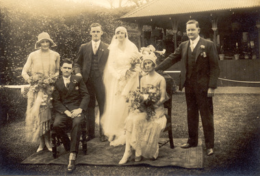 Chelsea & District Historical Society Inc
Photograph - Jean Brown And Francis Anderson, Group Wedding Photo, 1930
... Creek to almost the Aspendale Railway Station. The property was a market garden and orchard. Mr Brown took an active interest in the public life of the community, a Justice of the Peace; Councillor of Dandenong Shire for over 30 years, was twice Shire President; and a founding member of the Mordialloc Mechanics Institute. Hugh Brown Mordialloc Jean Brown Zillah Brown Francis Anderson Wedding Margaret Watson Mary Anderson Bill Armstrong ...From Left to Right: Margaret Watson, Hugh Brown, Frank Anderson, Jean Brown, Mary Anderson, Bill Armstrong Zillah Jean Brown, known as Jean, was the granddaughter of a pioneer of the district, Mr Hugh Brown. Jean married Francis Anderson in October 1930. Hugh Brown (1830-1930), born in Ireland, arrived in Adelaide in 1855 and in the Mordialloc district in 1856. Mr Brown brought land in 1866 and built his farmhouse “Pine Vale” in 1870 near the site of the present Mordialloc Secondary College (then part of the property) and extended his property when the swampland was made open for selection in 1871. The property was a market garden and orchard. Hugh Brown married Zillah Baxter (1866) and they had six sons, five living to adulthood. The Brown family increased their land holding until they held a major part of the farmland between Mordialloc Creek to almost the Aspendale Railway Station. The property was a market garden and orchard. Mr Brown took an active interest in the public life of the community, a Justice of the Peace; Councillor of Dandenong Shire for over 30 years, was twice Shire President; and a founding member of the Mordialloc Mechanics Institute. Black and white studio photo of the wedding party of Miss Jean Brown and Mr Francis Anderson.hugh brown, mordialloc, jean brown, zillah brown, francis anderson, wedding, margaret watson, mary anderson, bill armstrong -
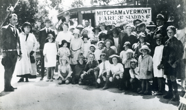 Whitehorse Historical Society Inc.
Photograph, Opening Bus Service, 1932-33
... Whitehorse Historical Society Inc. 2-10 Deep Creek Road Mitcham melbourne Part of Tim Shambrook's Collection for 'This is Vermont'. P.35. armstrong norman mitcham - vermont bus service shambrook tim nethercote mrs livermore joan livermore s d mrs. barnard mrs. ...Part of Tim Shambrook's Collection for 'This is Vermont'. P.35.Two copies of black and white photo of Norman Armstrong opening Mitcham to Vermont Bus Service in front of Crowd. 1932-2. Joan Livermore (Mrs Nethercote) wearing Tintern School hat (in front of man with cigarette). Mrs S.D. Livermore behind Joan. Mrs Barnard next to Norman Armstrong.armstrong, norman, mitcham - vermont bus service, shambrook, tim, nethercote, mrs, livermore joan, livermore s d mrs., barnard mrs. -
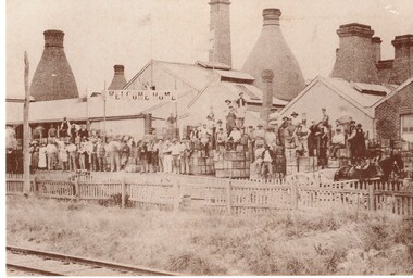 Whitehorse Historical Society Inc.
Postcard, Historic Postcard - Set 2 no 4- Aust Tess Tile Co, c1920
... Whitehorse Historical Society Inc. 2-10 Deep Creek Road Mitcham melbourne Armstrong Raleigh Edward Australian Brick and Tesselated Tile Co. ...Black and white historic postcard (Set 2 No 4 ) Australian Brick & Tesselated Tile Co, Mitcham in the 1920s. Workers outside the buildings. Original supplied by Raleigh Armstrong - 2 copiesarmstrong, raleigh edward, australian brick and tesselated tile co., nunawading library & information service -
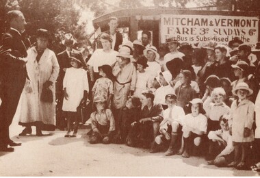 Whitehorse Historical Society Inc.
Postcard, Historic Postcard - Set 1 no 4 - Vermont - Mitcham Bus, 1/03/1924 12:00:00 AM
... Whitehorse Historical Society Inc. 2-10 Deep Creek Road Mitcham melbourne Mitcham - Vermont Bus Service Armstrong Ian Drake & Co Nunawading Library & Information Service Black and white historic postcard (Set 1 No4 ) Launching of Vermont-Mitcham Bus Service - March 1924. ...Black and white historic postcard (Set 1 No4 ) Launching of Vermont-Mitcham Bus Service - March 1924.|Original supplied by Ian Armstrong - Drake & Co Pty Ltdmitcham - vermont bus service, armstrong, ian, drake & co, nunawading library & information service -
 Whitehorse Historical Society Inc.
Postcard, Historic Postcard - Set 1 no 7 - Red Store, 1920s
... Whitehorse Historical Society Inc. 2-10 Deep Creek Road Mitcham melbourne Armstrong Raleigh Edward Red Store Mitcham Nunawading Library & Information Service Black and white historic postcard (Set 1 No 7 ) Red Store, Mitcham Road, south side of Whitehorse Road showing double fronted shop with two salesmen outside with goods for sale. ...Black and white historic postcard (Set 1 No 7 ) Red Store, Mitcham Road, south side of Whitehorse Road showing double fronted shop with two salesmen outside with goods for sale.|Original supplied by Raleigh Armstrong.armstrong, raleigh edward, red store, mitcham, nunawading library & information service -
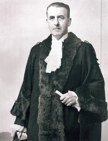 Whitehorse Historical Society Inc.
Photograph, Cr. Norm Armstrong - Mayor, 1945
... Whitehorse Historical Society Inc. 2-10 Deep Creek Road Mitcham melbourne armstrong norman shire of blackburn and mitcham shire presidents city of nunawading mayor Coloured Photograph of Cr. ...Coloured Photograph of Cr. Norman Armstrong, Mayor, City of Nunawading, August 1945 to August 1946. Cr Armstrong was Shire President of the Shire of Blackburn and Mitcham when the City of Nunawading was proclaimed on 30th May 1945, thus becoming the first Mayor of the city . He was also Shire President in 1929-30armstrong, norman, shire of blackburn and mitcham, shire presidents, city of nunawading, mayor -
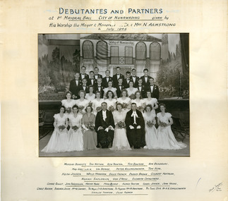 Whitehorse Historical Society Inc.
Photograph - Studio photograph, Mayoral Ball of City of Nunawading, July 1946, 14/07/1946 12:00:00 AM
... Whitehorse Historical Society Inc. 2-10 Deep Creek Road Mitcham melbourne doherty murray debutantes carruthers elizabeth rouget connie nation tom fankhauser joan tainton ken moore marion bowman beinke mary bradbury ron audrey karnaghan max jenner isabel val harris killingsworth huston grace elmi keith jelley barbara maddern wells french bruce coombes h. brown dudley charlesworth albert roy mottrom gilbert a shirley sheldrick norma olive o'neill vida debutante ball city of nunawading Framed black and white photo of 1st Mayoral Ball of City of Nunawading, July 1946. Mayor and Mayoress - Mr. & Mrs N. Armstrong ...Framed black and white photo of 1st Mayoral Ball of City of Nunawading, July 1946. Mayor and Mayoress - Mr. & Mrs N. Armstrong.doherty, murray, debutantes, carruthers, elizabeth, rouget, connie, nation, tom, fankhauser, joan, tainton, ken, moore, marion, bowman, beinke, mary, bradbury, ron, audrey, karnaghan, max, jenner, isabel, val, harris, killingsworth, huston, grace, elmi, keith, jelley, barbara, maddern, wells, french, bruce, coombes, h., brown, dudley, charlesworth, albert roy, mottrom, gilbert a, shirley, sheldrick, norma, olive, o'neill, vida, debutante ball, city of nunawading -
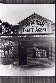 Whitehorse Historical Society Inc.
Photograph, Fred Drake Office
... Whitehorse Historical Society Inc. 2-10 Deep Creek Road Mitcham melbourne drake fred real estate agents armstrong ian Black/white - Fred Drake Real Estate Offices on Corner of Station Street and Colombo Street, Mitcham (later Drake and Company later principal Norman Armstrong.) ...Black/white - Fred Drake Real Estate Offices on Corner of Station Street and Colombo Street, Mitcham (later Drake and Company later principal Norman Armstrong.)drake, fred, real estate agents, armstrong, ian -
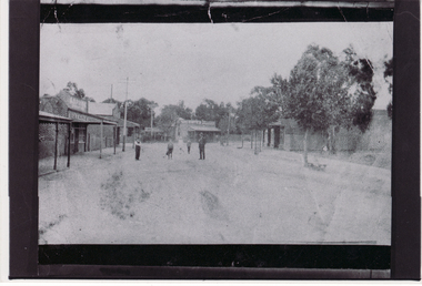 Whitehorse Historical Society Inc.
Photograph, Blackburn Road
... Whitehorse Historical Society Inc. 2-10 Deep Creek Road Mitcham melbourne blackburn road armstrong ian Black/white - Very early photo of beginning of Blackburn Road looking north towards railway crossing Blackburn Road Photograph Photograph ...Black/white - Very early photo of beginning of Blackburn Road looking north towards railway crossingblackburn road, armstrong, ian -
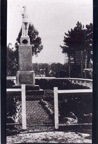 Whitehorse Historical Society Inc.
Photograph, Mitcham War Memorial
... Whitehorse Historical Society Inc. 2-10 Deep Creek Road Mitcham melbourne war memorial mitcham armstrong ian Black/white - Front view of Mitcham War memorial showing gate in the fence. ...Black/white - Front view of Mitcham War memorial showing gate in the fence. Memorial was in Whitehorse Road, Mitcham but moved to Halliday Park in Mitcham Roadwar memorial mitcham, armstrong, ian -
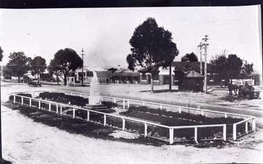 Whitehorse Historical Society Inc.
Photograph, Mitcham War Memorial
... Whitehorse Historical Society Inc. 2-10 Deep Creek Road Mitcham melbourne war memorial mitcham armstrong ian Black/white photo of Mitcham War Memorial when it was located in Centre of Whitehorse Road. ...Black/white photo of Mitcham War Memorial when it was located in Centre of Whitehorse Road. Since moved to Halliday Park. Note horse drawn cart on rightwar memorial mitcham, armstrong, ian -
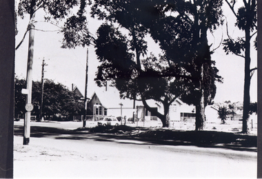 Whitehorse Historical Society Inc.
Photograph, Vermont Primary School
... Whitehorse Historical Society Inc. 2-10 Deep Creek Road Mitcham melbourne vermont primary school no. 1022 nurlendi road vermont canterbury road mitcham road armstrong ian Black/white - Vermont Primary School located on corner of Canterbury and Mitcham Roads, Vermont. ...Black/white - Vermont Primary School located on corner of Canterbury and Mitcham Roads, Vermont. Buildings moved in 1980's to Primary School in Nurlendi Road, Vermontvermont primary school no. 1022, nurlendi road, vermont, canterbury road, mitcham road, armstrong, ian -
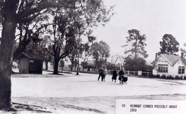 Whitehorse Historical Society Inc.
Photograph, Vermont Corner
... Whitehorse Historical Society Inc. 2-10 Deep Creek Road Mitcham melbourne vermont primary school no. 1022 canterbury road vermont mitcham road boronia road mitcham armstrong ian Black/white - Vermont - Corner of Canterbury Road and Mitcham-Boronia Roads with Vermont Primary School, possibly about 1950 Vermont Corner Photograph Photograph ...Black/white - Vermont - Corner of Canterbury Road and Mitcham-Boronia Roads with Vermont Primary School, possibly about 1950vermont primary school no. 1022, canterbury road, vermont, mitcham road, boronia road, mitcham, armstrong, ian