Showing 86 items matching "arthur bird"
-
 Eltham District Historical Society Inc
Photograph, Bird family Orchard, Pitt Street, Eltham, c.1980s
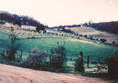
... ...arthur bird...In 1862 he purchased land in the east end of Pitt Street bounded by Eucalyptus Road and Wattle Grove and established a mixed farm and orchard. His son, Arthur Bird succeeded him and also worked on this orchard which then passed to Arthur's son, Harold Bird OAM, where Harold and Yvonne Bird lived in the family home till the mid 2000s ...In 1862 he purchased land in the east end of Pitt Street bounded by Eucalyptus Road and Wattle Grove and established a mixed farm and orchard. His son, Arthur Bird succeeded him and also worked on this orchard which then passed to Arthur's son, Harold Bird OAM, where Harold and Yvonne Bird lived in the family home till the mid 2000s aos6 wattle grove pitt street arthur bird bird family orchard eucalyptus road george bird harold bird yvonne bird eltham A4 size photographic print reproduction of a painting Bird family Orchard, Pitt Street, Eltham, c.1980s Photograph ...View looking northeast from near junction of Wattle Grove and Mount Pleasant Road across to Eucalyptus Road on right and Pitt Street at top. Early pioneer, George Bird Snr. arrived from England in 1852 and lived with his uncle, George Stebbing. He worked for him as bricklayer's assistant in building, among others, the Anglican and Methodist Churches in Eltham. In 1862 he purchased land in the east end of Pitt Street bounded by Eucalyptus Road and Wattle Grove and established a mixed farm and orchard. His son, Arthur Bird succeeded him and also worked on this orchard which then passed to Arthur's son, Harold Bird OAM, where Harold and Yvonne Bird lived in the family home till the mid 2000s A4 size photographic print reproduction of a paintingaos6, wattle grove, pitt street, arthur bird, bird family orchard, eucalyptus road, george bird, harold bird, yvonne bird, eltham -
 Eltham District Historical Society Inc
Photograph, Bird family Orchard, Pitt Street, Eltham, c.1980s, 1980s
... ...arthur bird...In 1862 he purchased land in the east end of Pitt Street bounded by Eucalyptus Road and Wattle Grove and established a mixed farm and orchard. His son, Arthur Bird succeeded him and also worked on this orchard which then passed to Arthur's son, Harold Bird OAM, where Harold and Yvonne Bird lived in the family home till the mid 2000s ...In 1862 he purchased land in the east end of Pitt Street bounded by Eucalyptus Road and Wattle Grove and established a mixed farm and orchard. His son, Arthur Bird succeeded him and also worked on this orchard which then passed to Arthur's son, Harold Bird OAM, where Harold and Yvonne Bird lived in the family home till the mid 2000s aos6 wattle grove pitt street arthur bird bird family orchard eucalyptus road george bird harold bird yvonne bird eltham A4 size photographic print Bird family Orchard, Pitt Street, Eltham, c.1980s Photograph ...View looking northeast from near junction of Wattle Grove and Mount Pleasant Road across to Eucalyptus Road on right and Pitt Street at top. Early pioneer, George Bird Snr. arrived from England in 1852 and lived with his uncle, George Stebbing. He worked for him as bricklayer's assistant in building, among others, the Anglican and Methodist Churches in Eltham. In 1862 he purchased land in the east end of Pitt Street bounded by Eucalyptus Road and Wattle Grove and established a mixed farm and orchard. His son, Arthur Bird succeeded him and also worked on this orchard which then passed to Arthur's son, Harold Bird OAM, where Harold and Yvonne Bird lived in the family home till the mid 2000s A4 size photographic printaos6, wattle grove, pitt street, arthur bird, bird family orchard, eucalyptus road, george bird, harold bird, yvonne bird, eltham -
 Eltham District Historical Society Inc
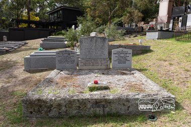
Photograph, Peter Pidgeon, Graves of George and Janet Bird and family, Eltham Cemetery, Victoria, 5 April 2021
... ...arthur bird...(Roger) Bird 1927 2001 Son of Arthur & Helen (nee Lyon) Bird Husband of Betty Father of Janet & Alison Grandpa of Evan & Helen Scientist & Gentleman To the right In Loving Memory of Harold Edwin Bird OAM 1922 - 2015 Son of Arthur & Helen (nee Lyon) Bird Husband of Yvonne Father of Estell & Russell In our hearts Forever more...(Roger) Bird 1927 2001 Son of Arthur & Helen (nee Lyon) Bird Husband of Betty Father of Janet & Alison Grandpa of Evan & Helen Scientist & Gentleman To the right In Loving Memory of Harold Edwin Bird OAM 1922 - 2015 Son of Arthur & Helen (nee Lyon) Bird Husband of Yvonne Father of Estell & Russell In our hearts Forever more eltham cemetery gravestones arthur andrew bird arthur bird edwin john bird george bird george hugh bird harold edwin bird helen bird (nee lyon) j. r. ...George Bird was born in England in 1845 and arrived in Australia in 1856 as a child of assisted migrants. Soon afterwards he came out to Eltham to live with his uncle George Stebbings, working for him as bricklayer's assistant in building, amongst others, Shillinglaw Cottage and the Anglican and Methodist Churches in Eltham. He later purchased 72 acres at the eastern end of Pitt Street (bounded by Eucalyptus Road, Mount Pleasant Road and present-day Rockliffe Street) and established the property ‘View Hill’, which was worked as a mixed farm and orchard (including berries). In 1878 he married Janet Kilpatrick, who had emigrated from Scotland. They had ten children, three of whom died in infancy. The wedding in 1904 of their eldest surviving daughter Sarah (‘Sis’) to Edward Pepper appears to have been quite a society event. George was a staunch Methodist and was a Church Steward and a Sunday School Superintendent in about 1890. Janet died in 1915 and George died in 1920 (though his gravestone says 1921). George's will stated that his property was to be divided between all his children in equal shares. This necessitated subdivision of the View Hill property, which took place progressively between 1922 and 1926. One son, George Hugh Bird, operated a drapery store in Main Road (near Bridge Street) in around 1915. Later, in the 1920s, he ran a greengrocer's shop (also selling confectionery) in Main Road opposite Eltham Station. It was the first shop in Eltham to have plate glass windows. At the same time, his brother Reg had a grocery store on the station side of Main Road. George and Janet are buried together in a family plot in Eltham Cemetery. Several descendants are also buried in the cemetery. In Loving Memory Of George Bird Died 5 December 1921 aged 76 years And his beloved wife Janet Bird Died 5 Sept 1915 aged 57 years Also their children William James Bird Died 25 Feb 1888 aged 8 years Mary Jane Bird Died 8 Oct 1891 aged 7 years Pte Edwin John Bird Killed in action in the Great War 11 Aug 1918 aged 30 years Buried in France And on the base stone George Hugh Bird Died 26 Feb. 1965. Aged 79 years Arthur Andrew Bird Died 25 Mar. 1970 Aged 75 years To the left In Loving Memory of Dr. J. R. (Roger) Bird 1927 2001 Son of Arthur & Helen (nee Lyon) Bird Husband of Betty Father of Janet & Alison Grandpa of Evan & Helen Scientist & Gentleman To the right In Loving Memory of Harold Edwin Bird OAM 1922 - 2015 Son of Arthur & Helen (nee Lyon) Bird Husband of Yvonne Father of Estell & Russell In our hearts Forever moreBorn Digitaleltham cemetery, gravestones, arthur andrew bird, arthur bird, edwin john bird, george bird, george hugh bird, harold edwin bird, helen bird (nee lyon), j. r. (roger) bird, janet bird (nee kilpatrick), william james bird, yvonne bird -
 Eltham District Historical Society Inc
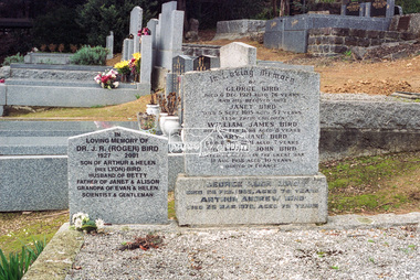
Negative - Photograph, Harry Gilham, Graves of George and Janet Bird and family, Eltham Cemetery, Victoria, 1 Aug 2007
... ...Arthur Bird...(Roger) Bird 1927 2001 Son of Arthur & Helen (nee Lyon) Bird Husband of Betty Father of Janet & Alison Grandpa of Evan & Helen Scientist & Gentleman To the right In Loving Memory of Harold Edwin Bird OAM 1922 - 2015 Son of Arthur & Helen (nee Lyon) Bird Husband of Yvonne Father of Estell & Russell In our hearts Forever more...(Roger) Bird 1927 2001 Son of Arthur & Helen (nee Lyon) Bird Husband of Betty Father of Janet & Alison Grandpa of Evan & Helen Scientist & Gentleman To the right In Loving Memory of Harold Edwin Bird OAM 1922 - 2015 Son of Arthur & Helen (nee Lyon) Bird Husband of Yvonne Father of Estell & Russell In our hearts Forever more Eltham Cemetery Gravestones Memorials Arthur Andrew Bird Arthur Bird Edwin John Bird George Bird George Hugh Bird Harold Edwin Bird Helen Bird (nee Lyon) J. ...George Bird was born in England in 1845 and arrived in Australia in 1856 as a child of assisted migrants. Soon afterwards he came out to Eltham to live with his uncle George Stebbings, working for him as bricklayer's assistant in building, amongst others, Shillinglaw Cottage and the Anglican and Methodist Churches in Eltham. He later purchased 72 acres at the eastern end of Pitt Street (bounded by Eucalyptus Road, Mount Pleasant Road and present-day Rockliffe Street) and established the property ‘View Hill’, which was worked as a mixed farm and orchard (including berries). In 1878 he married Janet Kilpatrick, who had emigrated from Scotland. They had ten children, three of whom died in infancy. The wedding in 1904 of their eldest surviving daughter Sarah (‘Sis’) to Edward Pepper appears to have been quite a society event. George was a staunch Methodist and was a Church Steward and a Sunday School Superintendent in about 1890. Janet died in 1915 and George died in 1920 (though his gravestone says 1921). George's will stated that his property was to be divided between all his children in equal shares. This necessitated subdivision of the View Hill property, which took place progressively between 1922 and 1926. One son, George Hugh Bird, operated a drapery store in Main Road (near Bridge Street) in around 1915. Later, in the 1920s, he ran a greengrocer's shop (also selling confectionery) in Main Road opposite Eltham Station. It was the first shop in Eltham to have plate glass windows. At the same time, his brother Reg had a grocery store on the station side of Main Road. George and Janet are buried together in a family plot in Eltham Cemetery. Several descendants are also buried in the cemetery. In Loving Memory Of George Bird Died 5 December 1921 aged 76 years And his beloved wife Janet Bird Died 5 Sept 1915 aged 57 years Also their children William James Bird Died 25 Feb 1888 aged 8 years Mary Jane Bird Died 8 Oct 1891 aged 7 years Pte Edwin John Bird Killed in action in the Great War 11 Aug 1918 aged 30 years Buried in France And on the base stone George Hugh Bird Died 26 Feb. 1965. Aged 79 years Arthur Andrew Bird Died 25 Mar. 1970 Aged 75 years To the left In Loving Memory of Dr. J. R. (Roger) Bird 1927 2001 Son of Arthur & Helen (nee Lyon) Bird Husband of Betty Father of Janet & Alison Grandpa of Evan & Helen Scientist & Gentleman To the right In Loving Memory of Harold Edwin Bird OAM 1922 - 2015 Son of Arthur & Helen (nee Lyon) Bird Husband of Yvonne Father of Estell & Russell In our hearts Forever moreeltham cemetery, gravestones, memorials, arthur andrew bird, arthur bird, edwin john bird, george bird, george hugh bird, harold edwin bird, helen bird (nee lyon), j. r. (roger) bird, j.r. (roger) bird, janet bird, janet bird (nee kilpatrick), william james bird, yvonne bird -
 Eltham District Historical Society Inc
Negative - Photograph, Harry Gilham, Grave of Annie Lyon (1918) and Helen Bird nee Lyon (1897-1993), Eltham Cemetery, Victoria, Sep 2009
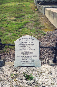
... ...Arthur Andrew Bird...In Loving Memory of Annie Lyon Widow of the late Andrew Lyon of Mildura Died 12th March 1918 and of Helen Bird Widow of Arthur Andrew Bird Daughter of Annie Lyon Died 4th July 1993 Aged 96 years...Eltham District Historical Society Inc 728 Main Rd Eltham melbourne In Loving Memory of Annie Lyon Widow of the late Andrew Lyon of Mildura Died 12th March 1918 and of Helen Bird Widow of Arthur Andrew Bird Daughter of Annie Lyon Died 4th July 1993 Aged 96 years Andrew Lyon Annie Lyon Arthur Andrew Bird Eltham Cemetery Gravestones Helen Bird (nee Lyon) Kodak GC 400-9 Roll of 35mm colour negative film, 6 strips Grave of Annie Lyon (1918) and Helen Bird nee Lyon (1897-1993), Eltham Cemetery, Victoria Negative Photograph Harry Gilham ...In Loving Memory of Annie Lyon Widow of the late Andrew Lyon of Mildura Died 12th March 1918 and of Helen Bird Widow of Arthur Andrew Bird Daughter of Annie Lyon Died 4th July 1993 Aged 96 yearsRoll of 35mm colour negative film, 6 stripsKodak GC 400-9andrew lyon, annie lyon, arthur andrew bird, eltham cemetery, gravestones, helen bird (nee lyon) -
 Eltham District Historical Society Inc
Document - Folder, Shillinglaw family
... ...Arthur Bird...George Shillinglaw Thomas Shillinglaw William Shillinglaw Andrew Shillinglaw Philip Shillinglaw Anne Shillinglaw Caroline Shillinglaw Edward Edwards Philip Edwards Caroline Edwards James Edwards Charlotte Edwards Margaret Edwards Edith Edwards Elizabeth Edwards Marth Edwards Sarah Ann Kidd Sarah Ann Shillinglaw Jane Shillinglaw Christopher Watson Jean Watson Elizabeth Ann Shillinglaw Mary Ann Shillinglaw Margaret Susan Shillinglaw Alfred Philip Shillinglaw Arthur James Shillinglaw Florence May Shillinglaw Edward Thomas Bunker Edward Ernest Bunker Sebella Doris Noye Florence Joyce Bunker Graham Leslie Gibson Lehanne Gibson Glenn Leslie Gibson Janine Gibson Ernest Geoffrey Bunker Shirley Mary Sealy Wayne Geoffrey Bunker Jennifer Thorton Leslie Bunker Anthony Bunker Bruce Bunker Christina Bunker Robin Gaye Bunker Colin Anderson Malcolm Stewart Anderson Yana Gaye Anderson Alisha Rae Anderson Carley Johanna Anderson Debby Lee Bunker Christopher Alan McGeachin Ronald Graham Woof Benjamine Alan McGeachin Scott William McGeachin Justin Lee McGeachin Brit Raymond Woff Kerry Ann Woff Ronald James woff Sharon Mary Bunker Dennis Alfred Kernaghan Terry Alfred Kernaghan Jason Jeffrey Kernaghan Michelle Ann Bunker Christopher Hayes Ian Lindsay Eastlake Shane Anthony Bunker Arron John Hayes Cheryl Eastlake Troy William Eastlake Philip Alan Bunker Ethol Myra Bunker Richard Johnson Sadie Forence Bunker Walter Hardley Margaret Hardley Ernest John Ball Robert John Ball Sharon Ann Ball Damien Sproule-Carroll Kieran Peter Sproule-Carroll Riley John Sproule-Carroll Tyson Josh Sproule-Carroll Elyshia Jade Sproule-Carroll Elizabeth Hardley John Ewan Horton Keith Campbell Bell Paula Nash Sarah Mounsey Winona Horton Ned Robert Horton Archie James Horton Kiraly Ewan Horton Andrew Burgess Finley Rusty Burgess Rose Elizabeth Jonty Burgess Zoe Vera Pat Burgess Wade James Ewan Horton Simone O'Reilly Matthew John Ewan Horton Ethan Jude Walter Horton William John Leslie Horton Ada Eveleen Bunker Walter Britton Lorna Valerie Britton Graeme Bunton Donna Lee Britton Steve McLeod Gavin McLeod Dannielle McLeod Nicole McLeod Adam McLeod Andrew Graeme Bunton Lyle Walter Britton Denise Britton Karen Britton Robin Britton Zade Lookie Ryan Lookie Matt Lookie Graeme Britton Wendy Harris Jason Britton Laurel Britton Marjorie Eveleen Britton Brian Reid Paul Reid Diane Reid Brandon Reid Catelyn Reid Julie Reif Ronald Edward Britton Megan Britton Sean Britton Michelle Britton Dorothy Joan Britton Graham Paul Deona Paul Lucas Paul Fletcher Paul Cohen Paul Oakley Paul Ian Leslie Britton Gordon Keith Bunker Jean Kinsmore Alan Gordon Bunker Lorraine Bunker Jimmy Pryor Sue Pryor Lindy Pryor Craig Pryor Dannielle Pryor Jessica Pryor Dylan Pryor Kaytlin Pryor Davin Pryor Rebecca Pryor Nicole Pryor Maurice Bunker Marjorie McNelley Maurine Isobel Bradley Rowina Lee Bunker Justin Dale Bunker Doris Bunker Eva Bessie Bunker John Ramsay Trevena Myra Edith Trevena Jeffrey Charles Amey Carolyn Amey Michael Andrew Aitkin Wesley Matthew Amery June Dulcie Trevena Michael Scorgie Mark Andrew Scorgie Vickie Berry Nyssa Scorgie Paul Timothy Scorgie Philip David Scorgie Marien Ludus Peter John Trevena Lesley Richardson Craig Trevena Lisa Helen Trevena Rhonda Jean Trevena Richard Maurice Lawrence Matthew Stewart Lawrence Glenn Richard Lawrence Ernest Samuel Shillinglaw Anna Lucy Barlow Melva Lucie Shillinglaw Donald George Richards Katheryn Lucille Richards Philip Scicluna Leslie Ernest Shillinglaw Kenneth Ernest Shillinglaw Valerie Joy Shillinglaw Lynette Ann Shillinglaw Heather Marie Shillinglaw Philip John Shillinglaw Raymond Leslie Shillinglaw Ada Maria Shillinglaw William Pearce Chrisfield Mary Shillinglaw William James Somerville Joseph Shillinglaw Jane Davidson Samuel Shillinglaw Agnes Mary McIntosh Arthur Samuel Shillinglaw Agnes Mary Shillinglaw Barbara Ethol Shillinglaw Lillian Muriel Shillinglaw Elsie Gladys Shillinglaw Catherine Shillinglaw Edward Bottle Sarah Shillinglaw Charles Aldous Margaret Shillinglaw James Shillinglaw Elizabeth Shillinglaw John Docherty Ann Shillinglaw William Henry Long John Peter Long Mary Ann Long Elizabeth Ann Clements Doras Pearce Lillias Long Bertha Long Eliza Long Arthur Long Hedley Long Agnes Long Philip Thomas Long Martha Agnes Long Ella-Fanny Long Martha Shillinglaw William Lilburne Liliac Whilhelmina Lilburne Arthur Edmond Lilburne Claire Jepson William Harvey Lilburne John Ross Margaret Wilson James Bird Mary Ann Bird William Bird Sarah Ann Bird William Kidd Caroline Bird Jane Bird Maria Bird George Stebbing George Kidd Janet Bird Ship Fairlie master R Cowan Janet Kilpatrick William James Bird Mary Jane Bird George Hugh Bird Edwin John Bird Edward Ernest Pepper George Pepper Ernest Henry Pepper Francis Pepper Howard Pepper David Pepper Jessie Pepper Ivan Pepper Evelyn Bird Ernest Reginald Bird Arthur Andrew Bird Ellen May Bird Ada Janet Bird Helen Lyon Harold Bird Roger Bird William Mealy Edwin Mealy Lloyd Mealy Warwick Mealy Winifred Mealy Janet Mealy Stan Lowe Dave Lowe Alie Lowe Beryl Lowe Ted Lowe Lily Low Elleen Lowe Samuel Kidd John Kilpatrick Mary Gilmour James Logan Ship Talbot Thomas Kidd Sarah Kidd James Kidd Caroline Kidd Adeline Kidd Sabina Kidd Susan Kidd Jane Kidd Mathew Kidd Maria Kidd Mary Kidd James Kilpatrick Sarah Boxen Jane Kilpatrick Hugh Kilpatrick Mary Kilpatrick William Bridbane Sarah Kilpatrick William Kilpatrick Andrew Kilpatrick David Kilpatrick Emily Saunders Montague Pepper William Pepper Catherine Pepper Albert Pepper Henriette Pepper Alexander Pepper Alice Pepper Edward Pepper Sarah Pepper Sarah Bird Mary Bird George Bird Edwin Bird Ada Bird Ellen Bird Arthur Bird Reginald Bird Carline Bird Ruth Logan John Logan Jane Logan William Logan Helen Logan Andrew Logan Hugh Logan Mary Logan Sarah Logan Sarah Anne Bird Ernest Pepper Frank Pepper Jne Perrin nee Brown Marriott's market garden Bentleigh David Lowe Alice Lowe Ten Lowe Lily Lowe Eileen Lowe Nell Bird 204 Pitt Street Eltham Wendy Bird Very Bird Bird Bros Eltham Yarra Valley Mills Marlene Bird Duncan Fraser View Hill Pitt Streeet Eltham Eltham Methodist Church Hilda Pepper Rickliffe Stret Eltham View Hill Crescent Eltham Ann Tonkin James Clark Margaret Tonkin Richard Martin Sarah Tonkin Duncan McCallum Isabella Tonkin Thomas Giblett Flora Tonkin John Sinclair Strachan Carol Tonkin Samuel Wood Charlotte Tonkin John Thomas Moyes Albertha Tonkin Leslie Frederick Burley Goodwin Alexandrina Hutchinson Tonkin William Henry Johns Florateina Tonkin Benjamin Clayton Henrietta Tonkin William Johansen Caroline Farie Kidd Ruth Wilson Alexander Stewart James George Reynolds Alice Jackson Reynolds William Henry Mills Alfred Mason Matthew Kidd Mary Ann Kidd Alexander Kirk Stewart Caroline Fairlie Kidd Grace McKenzie James Leslie Stewart William Alexander Stewart Olive Rose Stewart Alfred Henry Grimshaw John Lee Grimshaw Mary Yates Angus George Stewart Percival Roy Stewart Clive Thornton Stewart Amy Cunningham Mary Anne Kidd James G Renolds William A Williams Aldous family Barlow family Bird family Blemmier family Bottle family Britton family Brown family Bunker family Crichton family Christfield family Docherty family Hobson family Hardley family Johnston family Kidd family Kinsmore family Lilburne family Long family MacRobinson family McGrath family McIntosh family McNelley family Murphy family Noble family Noye family Somerville family Taylor family Trevena family Trivett family Watson family White family Margaret Ball Corrie Shillinglaw Carrie Watson Melva Lucie Richards Kathryn Richardson Barque India Ship Roland Shillinglaw Cottage Raymond Shillinglaw Valerie Shillinglaw Lynette Shillinglaw Heather Shillinglaw Melva Lucie Richards nee Shillinglaw Carrie Shillinglaw nee Watson J R Trevena nee Bunker W Hardley nee Bunker Sadie Hartley nee Bunker Dupplin Gardens Coburg Jean Shillinglaw nee Blemner Sarah Ann Shillinglaw nee Kidd Helen Castafaro nee Shillinglaw Lesley Ernest Shillinglaw Helen Shillinglaw Jean Shilling nee Blemner Sarah Aldous nee Shillinglaw Florence May Beerereg nee Shillinglaw Elizabeth Annie Mooney nee Aldous James Mooney Percival John Aldous Ada Lillian Wilson nee Aldous Charles Douglas Wilson Alice Blemner Gunn nee Aldous Ernest James Gunn Ethel Vera Brian nee Aldous Thomas Lindsay Brian Peter Brian Thomas Brian John Aldous Anna Marion Aldous nee Read Elizabeth Ann Aldous Elizabeth Annie Aldous Florence May Aldous Alice Blamire Gunn nee Aldous William Beere Charles Peace Ethel Vera Aldous Phillip Shillinglaw Elizabeth Crawford Ship India Martha Lilburne nee Shillinglaw Newspaper clippings, A4 photocopies, etc Shillinglaw family Document Folder ...Phillip Shillinglaw and four of his children arrived in the Port Phillip District in 184, travelling on the "India". His grandson, also Phillip, settled in Eltham where his house, Shillinglaw Cottage, still stands. Contents Sleeve containing list of "Descendants of George Shillinglaw". Sleeve containing "Bird family tree". Sleeve containing "Kidd family history". Sleeve containing Shillinglaw and Aldous connection Flier: "150th Anniversary Shillinglaw Family, 20 October 1991". Photograph: Shllinglaw group, 1 January 1909. Photograph: Shillinglaw group with carriage, 1907. Sleeve containing two lists of Bunker family members. Photocopy of Will of Philip Shillinglaw dated 6 September 1913. Letter Ken Shillinglaw to EDHS, 12 December 1980: Provides information on Shillinglaw family and Shillinglaw Cottage. Newsletter items: "Shillinglaw Family History:, Eltham District Historical Society, January 2008 and March 2008. Email Helen Castafaro nee Shillinglaw, 7 March 2013: Enquiring about Shillinglaw family bible. Funeral notice and Tribute: Melva Lucie Richards, 2 October 2017. Journal article: "Glad were they to rest on Australia's Shore", Ancestors, March 2008. Elizabeth Crawford's story of Philip Shillinglaw and children. Printout, "Eltham Court, Tuesday, February 21", Advertiser, 22 February 1929.Elizabeth Shillinglaw fined for filing to destroy noxious weeks under the Vermin and Noxious Weeds Act. Sleeve containing "About the Shillinglaws", Borders Family History Society Newsletter 5, November 1987; map of Shillinglaw Wall; leaflet "Traquair"; Note that material is not connected to Eltham Shillinglaw family according to Margaret Ball September 2017. Newspaper clippings, A4 photocopies, etcgeorge shillinglaw, thomas shillinglaw, william shillinglaw, andrew shillinglaw, philip shillinglaw, anne shillinglaw, caroline shillinglaw, edward edwards, philip edwards, caroline edwards, james edwards, charlotte edwards, margaret edwards, edith edwards, elizabeth edwards, marth edwards, sarah ann kidd, sarah ann shillinglaw, jane shillinglaw, christopher watson, jean watson, elizabeth ann shillinglaw, mary ann shillinglaw, margaret susan shillinglaw, alfred philip shillinglaw, arthur james shillinglaw, florence may shillinglaw, edward thomas bunker, edward ernest bunker, sebella doris noye, florence joyce bunker, graham leslie gibson, lehanne gibson, glenn leslie gibson, janine gibson, ernest geoffrey bunker, shirley mary sealy, wayne geoffrey bunker, jennifer thorton, leslie bunker, anthony bunker, bruce bunker, christina bunker, robin gaye bunker, colin anderson, malcolm stewart anderson, yana gaye anderson, alisha rae anderson, carley johanna anderson, debby lee bunker, christopher alan mcgeachin, ronald graham woof, benjamine alan mcgeachin, scott william mcgeachin, justin lee mcgeachin, brit raymond woff, kerry ann woff, ronald james woff, sharon mary bunker, dennis alfred kernaghan, terry alfred kernaghan, jason jeffrey kernaghan, michelle ann bunker, christopher hayes, ian lindsay eastlake, shane anthony bunker, arron john hayes, cheryl eastlake, troy william eastlake, philip alan bunker, ethol myra bunker, richard johnson, sadie forence bunker, walter hardley, margaret hardley, ernest john ball, robert john ball, sharon ann ball, damien sproule-carroll, kieran peter sproule-carroll, riley john sproule-carroll, tyson josh sproule-carroll, elyshia jade sproule-carroll, elizabeth hardley, john ewan horton, keith campbell bell, paula nash, sarah mounsey, winona horton, ned robert horton, archie james horton, kiraly ewan horton, andrew burgess, finley rusty burgess, rose elizabeth jonty burgess, zoe vera pat burgess, wade james ewan horton, simone o'reilly, matthew john ewan horton, ethan jude walter horton, william john leslie horton, ada eveleen bunker, walter britton, lorna valerie britton, graeme bunton, donna lee britton, steve mcleod, gavin mcleod, dannielle mcleod, nicole mcleod, adam mcleod, andrew graeme bunton, lyle walter britton, denise britton, karen britton, robin britton, zade lookie, ryan lookie, matt lookie, graeme britton, wendy harris, jason britton, laurel britton, marjorie eveleen britton, brian reid, paul reid, diane reid, brandon reid, catelyn reid, julie reif, ronald edward britton, megan britton, sean britton, michelle britton, dorothy joan britton, graham paul, deona paul, lucas paul, fletcher paul, cohen paul, oakley paul, ian leslie britton, gordon keith bunker, jean kinsmore, alan gordon bunker, lorraine bunker, jimmy pryor, sue pryor, lindy pryor, craig pryor, dannielle pryor, jessica pryor, dylan pryor, kaytlin pryor, davin pryor, rebecca pryor, nicole pryor, maurice bunker, marjorie mcnelley, maurine isobel bradley, rowina lee bunker, justin dale bunker, doris bunker, eva bessie bunker, john ramsay trevena, myra edith trevena, jeffrey charles amey, carolyn amey, michael andrew aitkin, wesley matthew amery, june dulcie trevena, michael scorgie, mark andrew scorgie, vickie berry, nyssa scorgie, paul timothy scorgie, philip david scorgie, marien ludus, peter john trevena, lesley richardson, craig trevena, lisa helen trevena, rhonda jean trevena, richard maurice lawrence, matthew stewart lawrence, glenn richard lawrence, ernest samuel shillinglaw, anna lucy barlow, melva lucie shillinglaw, donald george richards, katheryn lucille richards, philip scicluna, leslie ernest shillinglaw, kenneth ernest shillinglaw, valerie joy shillinglaw, lynette ann shillinglaw, heather marie shillinglaw, philip john shillinglaw, raymond leslie shillinglaw, ada maria shillinglaw, william pearce chrisfield, mary shillinglaw, william james somerville, joseph shillinglaw, jane davidson, samuel shillinglaw, agnes mary mcintosh, arthur samuel shillinglaw, agnes mary shillinglaw, barbara ethol shillinglaw, lillian muriel shillinglaw, elsie gladys shillinglaw, catherine shillinglaw, edward bottle, sarah shillinglaw, charles aldous, margaret shillinglaw, james shillinglaw, elizabeth shillinglaw, john docherty, ann shillinglaw, william henry long, john peter long, mary ann long, elizabeth ann clements, doras pearce, lillias long, bertha long, eliza long, arthur long, hedley long, agnes long, philip thomas long, martha agnes long, ella-fanny long, martha shillinglaw, william lilburne, liliac whilhelmina lilburne, arthur edmond lilburne, claire jepson, william harvey lilburne, john ross, margaret wilson, james bird, mary ann bird, william bird, sarah ann bird, william kidd, caroline bird, jane bird, maria bird, george stebbing, george kidd, janet bird, ship fairlie master r cowan, janet kilpatrick, william james bird, mary jane bird, george hugh bird, edwin john bird, edward ernest pepper, george pepper, ernest henry pepper, francis pepper, howard pepper, david pepper, jessie pepper, ivan pepper, evelyn bird, ernest reginald bird, arthur andrew bird, ellen may bird, ada janet bird, helen lyon, harold bird, roger bird, william mealy, edwin mealy, lloyd mealy, warwick mealy, winifred mealy, janet mealy, stan lowe, dave lowe, alie lowe, beryl lowe, ted lowe, lily low, elleen lowe, samuel kidd, john kilpatrick, mary gilmour, james logan, ship talbot, thomas kidd, sarah kidd, james kidd, caroline kidd, adeline kidd, sabina kidd, susan kidd, jane kidd, mathew kidd, maria kidd, mary kidd, james kilpatrick, sarah boxen, jane kilpatrick, hugh kilpatrick, mary kilpatrick, william bridbane, sarah kilpatrick, william kilpatrick, andrew kilpatrick, david kilpatrick, emily saunders, montague pepper, william pepper, catherine pepper, albert pepper, henriette pepper, alexander pepper, alice pepper, edward pepper, sarah pepper, sarah bird, mary bird, george bird, edwin bird, ada bird, ellen bird, arthur bird, reginald bird, carline bird, ruth logan, john logan, jane logan, william logan, helen logan, andrew logan, hugh logan, mary logan, sarah logan, sarah anne bird, ernest pepper, frank pepper, jne perrin nee brown, marriott's market garden bentleigh, david lowe, alice lowe, ten lowe, lily lowe, eileen lowe, nell bird, 204 pitt street eltham, wendy bird, very bird, bird bros eltham, yarra valley mills, marlene bird, duncan fraser, view hill pitt streeet eltham, eltham methodist church, hilda pepper, rickliffe stret eltham, view hill crescent eltham, ann tonkin, james clark, margaret tonkin, richard martin, sarah tonkin, duncan mccallum, isabella tonkin, thomas giblett, flora tonkin, john sinclair strachan, carol tonkin, samuel wood, charlotte tonkin, john thomas moyes, albertha tonkin, leslie frederick burley goodwin, alexandrina hutchinson tonkin, william henry johns, florateina tonkin, benjamin clayton, henrietta tonkin, william johansen, caroline farie kidd, ruth wilson, alexander stewart, james george reynolds, alice jackson reynolds, william henry mills, alfred mason, matthew kidd, mary ann kidd, alexander kirk stewart, caroline fairlie kidd, grace mckenzie, james leslie stewart, william alexander stewart, olive rose stewart, alfred henry grimshaw, john lee grimshaw, mary yates, angus george stewart, percival roy stewart, clive thornton stewart, amy cunningham, mary anne kidd, james g renolds, william a williams, aldous family, barlow family, bird family, blemmier family, bottle family, britton family, brown family, bunker family, crichton family, christfield family, docherty family, hobson family, hardley family, johnston family, kidd family, kinsmore family, lilburne family, long family, macrobinson family, mcgrath family, mcintosh family, mcnelley family, murphy family, noble family, noye family, somerville family, taylor family, trevena family, trivett family, watson family, white family, margaret ball, corrie shillinglaw, carrie watson, melva lucie richards, kathryn richardson, barque india, ship roland, shillinglaw cottage, raymond shillinglaw, valerie shillinglaw, lynette shillinglaw, heather shillinglaw, melva lucie richards nee shillinglaw, carrie shillinglaw nee watson, j r trevena nee bunker, w hardley nee bunker, sadie hartley nee bunker, dupplin gardens coburg, jean shillinglaw nee blemner, sarah ann shillinglaw nee kidd, helen castafaro nee shillinglaw, lesley ernest shillinglaw, helen shillinglaw, jean shilling nee blemner, sarah aldous nee shillinglaw, florence may beerereg nee shillinglaw, elizabeth annie mooney nee aldous, james mooney, percival john aldous, ada lillian wilson nee aldous, charles douglas wilson, alice blemner gunn nee aldous, ernest james gunn, ethel vera brian nee aldous, thomas lindsay brian, peter brian, thomas brian, john aldous, anna marion aldous nee read, elizabeth ann aldous, elizabeth annie aldous, florence may aldous, alice blamire gunn nee aldous, william beere, charles peace, ethel vera aldous, phillip shillinglaw, elizabeth crawford, ship india, martha lilburne nee shillinglaw -
 Eltham District Historical Society Inc
Folder, Bird
... Bird...Arthur Andrew Bird...Eltham District Historical Society Inc 728 Main Rd Eltham melbourne constable george bird Alexander Bird Alison Bird Arthur Andrew Bird Arthur Bird Edwin John Bird Eltham Cemetery George Bird George Hugh Bird george stebbings Harold Bird Helen Bird (nee Lyon) J.R. ...Folder of information including Constable George Bird, Caledonia, 1880s George Bird, Eltham, 1850s - 1921constable george bird, alexander bird, alison bird, arthur andrew bird, arthur bird, edwin john bird, eltham cemetery, george bird, george hugh bird, george stebbings, harold bird, helen bird (nee lyon), j.r. (roger) bird, janet bird, janet bird (nee kilpatrick), janet bird (nee kirkpatrick)*, russell bird, shillinglaw cottage, william james bird -
 Eltham District Historical Society Inc
Photograph, Peter Bassett-Smith, Queen Elizabeth II Coronation celebrations and parade, Eltham, Jun 1953
... ...Mrs Arthur Bird...Seear Mrs Alf Davis Mrs Arthur Bird Mrs E.P. Harmer Mrs F.E. Griffith Mrs Frank Davis Mrs Ham Mrs S.S. ...Three black and white photographsalf davis, anz bank, army, arthur street, bert bredle, ceremonies, civic functions, coronation, councillors, cr e.p. harmer, cr f.v. squire, cr frederick e. griffith, cr stanley s. addison, dave lyon house, eltham hall, eltham lower park, eltham shire office, eltham village, eltham, frank davis mhr, guard of honour, main road, mr c.g. seear, mrs alf davis, mrs arthur bird, mrs e.p. harmer, mrs f.e. griffith, mrs frank davis, mrs ham, mrs s.s. addison, mrs squire, parade, queen elizabeth ii coronation, r.j. (dick) ham, shopping centre -
 Eltham District Historical Society Inc
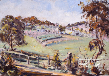
Painting, David Armfield, Mr Bird spraying his orchard, 1958
... Arthur Bird...Eltham District Historical Society Inc 728 Main Rd Eltham melbourne Presented to the Society by the artist Oil on canvas Arthur Bird artwork David Armfield Eltham Pitt Street Wattle Grove Mr Bird spraying his orchard Painting Painting David Armfield ...Presented to the Society by the artist Oil on canvasarthur bird, artwork, david armfield, eltham, pitt street, wattle grove -
 Eltham District Historical Society Inc
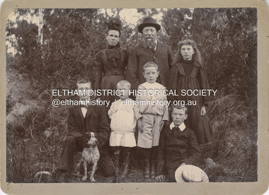
Photograph, Nicholes Photographers, Bird family, c.1905
... ...Arthur Andrew Bird...Bird family, c.1905 Back row, L-R: Janet Bird (nee Kilpatrick), George Bird, Ellen May (Nell) Bird Front row L-R: George Hugh Bird, Ernest Reginald Bird, Arthur Andrew Bird, Edwin John Bird Nicholes Photographer, Alphington According to the Sands McDougall Melbourne Directory, George. ...Eltham District Historical Society Inc 728 Main Rd Eltham melbourne Bird family, c.1905 Back row, L-R: Janet Bird (nee Kilpatrick), George Bird, Ellen May (Nell) Bird Front row L-R: George Hugh Bird, Ernest Reginald Bird, Arthur Andrew Bird, Edwin John Bird Nicholes Photographer, Alphington According to the Sands McDougall Melbourne Directory, George. ...Bird family, c.1905 Back row, L-R: Janet Bird (nee Kilpatrick), George Bird, Ellen May (Nell) Bird Front row L-R: George Hugh Bird, Ernest Reginald Bird, Arthur Andrew Bird, Edwin John Bird Nicholes Photographer, Alphington According to the Sands McDougall Melbourne Directory, George. Nicholes, Photographer was first listed on the north side of Heidelberg Road, Alphington in 1904 and again in 1905. By 1906 he was still listed but with no profession. From 1907 on he was listed as a bicycle agent. On July 23, 1878, George Bird married Janet Kilpatrick (born Ayrshire) at Northcote by Presbyterian minister, Duncan Fraser. The witnesses were daughters of the minister. George gave his profession as farmer. Around 1880 or possibly earlier he acquired the property known as View Hill at the top of Pitt Street, Eltham between Pitt Street and Mount Pleasant Road and what is now Eucalyptus Road. George and Janet developed an orchard and farm around the View Hill home and had 10 children, three of whom died young. George Bird is listed in the 1977 history of the Eltham Methodist Church as Steward and trustee in the early years. In the 1950 history he is mentioned as Sunday School Superintendent. In the early 1900s, Janet regularly went to the church by horse and jinker. Janet died September 2, 1915, age 60 of endocarditis and bronchial pneumonia. At about this time, three children had married (Sarah, George and Ada) and four were living at home. However, Edwin joined the AIF in August 1915 and Ellen married in 1916 leaving two sons, Arthur and Reg, to look after their father and the property although some of the married children may have lived at View Hill for some time. From Edwin's letters, Hilda Pepper, a cousin on their mother's side) stayed with the family for some time to help. In later years, George developed glaucoma and became blind. He died December 6, 1920, aged 75 years, of diabetes mellites. Both Janet and George are buried at Eltham Cemetery, but the gravestone incorrectly gives 1921 for the death of George. The estate was divided into equal portions and distributed to the surviving members with Arthur and Ted Pepper being Executors. Ada Janet Lowe received a portion above what is now Rockliffe Street and Sis Pepper (Sarah Ann nee Bird) the portion below Rockliffe Street. Ernest Pepper built in the 1930s on the Pepper block at the Pitt Street end. George's share was along Wattle Grove and Arthur received the portion at the eastern end. Presumably the other two received portions including the top of the hill and slopes down to Pitt Street, Mount Pleasant Road and Wattle Grove. Read's (at the corner of Pitt Street and View Hill Crescent) was the first additional house brought in on wheels by a Mr Walkenden. The View Hill house was occupied by the Johanssons in the 1930s and was later damaged by fire. Source: Info provided to Marg Ball by Neil and Lyn Pepper (both deceased) abt. 2018. PANEL 1875-1920 Panels began to be produced around 1875, and were particularly suited, because of their larger size, for capturing family, or even larger, groups. They measured 8.5 by 6.5 inches (22 cm x 16.5 cm). - Frost, Lenore; Dating Family Photos 1850-1920; Valiant Press Pty. Ltd., Berwick, Victoria 1991marg ball collection, 1905, arthur andrew bird, bird family, edwin john bird, ellen may (nell) bird, ernest reginald bird, george bird (1845-1921), george hugh bird, janet bird (nee kilpatrick), nicholes photographer alphington, straw boater -
 Eltham District Historical Society Inc
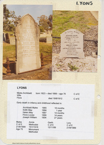
Document - Folder, Lyons, 2009-2010
... ...Arthur Andrew Bird...Eltham District Historical Society Inc 728 Main Rd Eltham melbourne Initially collated by Harry Gilham as part of a file on Eltham Cemetery eltham cemetery Andrew Lyon Annie Lyon Archibald Myles Lyons Arthur Andrew Bird Edith May Lyons Flora Louisa Lyons Flora Lyons Gravestones Helen Bird Helen May Lyons Hester May Lyons Joseph William Lyons Myles Archibald Lyons Eltham Police Folder of various items: photographs, photocopies, hand written notes pertaining to Archibald Myles Lyons Edith May Lyons Flora Louisa Lyons, Flora Lyons Helen May Lyons Hester May Lyons Joseph William Lyons Myles Archibald Lyons Lyons Document Folder ...Initially collated by Harry Gilham as part of a file on Eltham Cemeteryeltham cemetery, andrew lyon, annie lyon, archibald myles lyons, arthur andrew bird, edith may lyons, flora louisa lyons, flora lyons, gravestones, helen bird, helen may lyons, hester may lyons, joseph william lyons, myles archibald lyons, eltham police -
 Eltham District Historical Society Inc
Photograph, Frank Stokes with daughters Dorothy (left) and Beryl (right) at Stokes Orchard, Nyora Road, Eltham, 1944, 1944
... By chance he met Arthur Bird of Bird Orchard (bounded by Pitt Street, Eucalyptus Road and Wattle Grove) and they got talking over their common interest. ...By chance he met Arthur Bird of Bird Orchard (bounded by Pitt Street, Eucalyptus Road and Wattle Grove) and they got talking over their common interest. ...Frank Stokes first traveled to the district by train in 1944 to find land with the intention to establish an orchard. By chance he met Arthur Bird of Bird Orchard (bounded by Pitt Street, Eucalyptus Road and Wattle Grove) and they got talking over their common interest. Arthur put Frank up for the night and pointed out the land, part of Crown Allotment 15, Section 5, Parish of Nillumbik (CA15) somewhat diagonally opposite Bird Orchard. Frank bought the land and for the next two years would travel by train from Melbourne to Eltham every weekend establishing Stokes Orchard and building a home for his family, which they eventually moved into in 1946. In the mid 1970s the Shire of Eltham divided the orchard up into numerous rate-able parcel lots, which became affordable for Frank. As a consequence Stokes Orchard was turned into a housing development by Macquarie Builders and marketed as the Stokes Orchard Estate in two stages; Stage 1 encompassing Scarlet Ash Court, Ironbark Close and Peppermint Grove bounded by Nyora and Eucalyptus roads c.1976 and Stage 2 encompassing Stokes Place, Orchard Way, The Crest and The Lookout bound by Nyora and Diosma roads c.1979. The development of Orchard Way, The Crest and The Lookout did not proceed as planned due to the lack of the sewer along Diosma Road and so many of the proposed lots were incorporated into five-acre parcels instead.Representative of the orchard growing areas of ElthamDigital file only - Digitised by EDHS from a scrapbook (containing commercially printed photos of digital scans) on loan from Beryl Bradbury (nee Stokes), daughter of Frank Stokes.1944, beryl bradbury (nee stokes), beryl bradbury (nee stokes) collection, dorothy stokes, eltham, frank stokes, nyora road, stokes orchard -
 Eltham District Historical Society Inc
Photograph, Frank Stokes with his mother Florence (nee West) and children, Dorothy (left), David (centre) and Beryl (right), Stokes Orchard, Nyora Road, Eltham, c.1950, 1950c
... By chance he met Arthur Bird of Bird Orchard (bounded by Pitt Street, Eucalyptus Road and Wattle Grove) and they got talking over their common interest. ...By chance he met Arthur Bird of Bird Orchard (bounded by Pitt Street, Eucalyptus Road and Wattle Grove) and they got talking over their common interest. ...Frank's mother Florence was visiting from England at the time. Frank Stokes first traveled to the district by train in 1944 to find land with the intention to establish an orchard. By chance he met Arthur Bird of Bird Orchard (bounded by Pitt Street, Eucalyptus Road and Wattle Grove) and they got talking over their common interest. Arthur put Frank up for the night and pointed out the land, part of Crown Allotment 15, Section 5, Parish of Nillumbik (CA15) somewhat diagonally opposite Bird Orchard. Frank bought the land and for the next two years would travel by train from Melbourne to Eltham every weekend establishing Stokes Orchard and building a home for his family, which they eventually moved into in 1946. In the mid 1970s the Shire of Eltham divided the orchard up into numerous rate-able parcel lots, which became affordable for Frank. As a consequence Stokes Orchard was turned into a housing development by Macquarie Builders and marketed as the Stokes Orchard Estate in two stages; Stage 1 encompassing Scarlet Ash Court, Ironbark Close and Peppermint Grove bounded by Nyora and Eucalyptus roads c.1976 and Stage 2 encompassing Stokes Place, Orchard Way, The Crest and The Lookout bound by Nyora and Diosma roads c.1979. The development of Orchard Way, The Crest and The Lookout did not proceed as planned due to the lack of the sewer along Diosma Road and so many of the proposed lots were incorporated into five-acre parcels instead.Representative of the orchard growing areas of ElthamDigital file only - Digitised by EDHS from a scrapbook (containing commercially printed photos of digital scans) on loan from Beryl Bradbury (nee Stokes), daughter of Frank Stokes.1950, beryl bradbury (nee stokes), beryl bradbury (nee stokes) collection, david stokes, dorothy stokes, eltham, flatbed truck, florence stokes (nee west), frank stokes, nyora road, stokes orchard -
 Eltham District Historical Society Inc
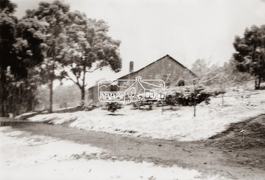
Photograph, The Stokes family home blanketed with snow, corner Nyora and Eucalyptus roads, Eltham, winter 1951, 1951
... By chance he met Arthur Bird of Bird Orchard (bounded by Pitt Street, Eucalyptus Road and Wattle Grove) and they got talking over their common interest. ...By chance he met Arthur Bird of Bird Orchard (bounded by Pitt Street, Eucalyptus Road and Wattle Grove) and they got talking over their common interest. ...Taken from outside the family home on the southest corner of the intersection of Nyora Road and Pitt Street with Eucalyptus Road. Frank Stokes first traveled to the district by train in 1944 to find land with the intention to establish an orchard. By chance he met Arthur Bird of Bird Orchard (bounded by Pitt Street, Eucalyptus Road and Wattle Grove) and they got talking over their common interest. Arthur put Frank up for the night and pointed out the land, part of Crown Allotment 15, Section 5, Parish of Nillumbik (CA15) somewhat diagonally opposite Bird Orchard. Frank bought the land and for the next two years would travel by train from Melbourne to Eltham every weekend establishing Stokes Orchard and building a home for his family, which they eventually moved into in 1946. In the mid 1970s the Shire of Eltham divided the orchard up into numerous rate-able parcel lots, which became affordable for Frank. As a consequence Stokes Orchard was turned into a housing development by Macquarie Builders and marketed as the Stokes Orchard Estate in two stages; Stage 1 encompassing Scarlet Ash Court, Ironbark Close and Peppermint Grove bounded by Nyora and Eucalyptus roads c.1976 and Stage 2 encompassing Stokes Place, Orchard Way, The Crest and The Lookout bound by Nyora and Diosma roads c.1979. The development of Orchard Way, The Crest and The Lookout did not proceed as planned due to the lack of the sewer along Diosma Road and so many of the proposed lots were incorporated into five-acre parcels instead.Representative of the orchard growing areas of Eltham. One of the rare times it has snowed in ElthamDigital file only - Digitised by EDHS from a scrapbook (containing commercially printed photos of digital scans) on loan from Beryl Bradbury (nee Stokes), daughter of Frank Stokes.1951, beryl bradbury (nee stokes) collection, eltham, eucalyptus road, nyora road, snow, stokes family home -
 Eltham District Historical Society Inc
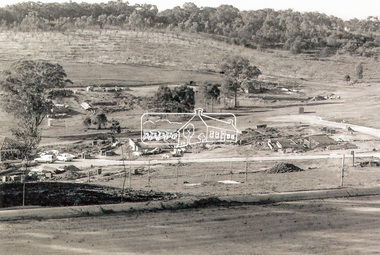
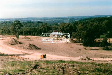
Photograph, The first houses in construction on the new Stokes Orchard Estate, July 1976, July 1976
... By chance he met Arthur Bird of Bird Orchard (bounded by Pitt Street, Eucalyptus Road and Wattle Grove) and they got talking over their common interest. ...By chance he met Arthur Bird of Bird Orchard (bounded by Pitt Street, Eucalyptus Road and Wattle Grove) and they got talking over their common interest. ...Viewed from near the Stokes family home at 1 Nyora Road looking northeast across Ironbark Close to Scarlet Ash Court with Peppermint Grove in the distance. Frank Stokes first traveled to the district by train in 1944 to find land with the intention to establish an orchard. By chance he met Arthur Bird of Bird Orchard (bounded by Pitt Street, Eucalyptus Road and Wattle Grove) and they got talking over their common interest. Arthur put Frank up for the night and pointed out the land, part of Crown Allotment 15, Section 5, Parish of Nillumbik (CA15) somewhat diagonally opposite Bird Orchard. Frank bought the land and for the next two years would travel by train from Melbourne to Eltham every weekend establishing Stokes Orchard and building a home for his family, which they eventually moved into in 1946. In the mid 1970s the Shire of Eltham divided the orchard up into numerous rate-able parcel lots, which became affordable for Frank. As a consequence Stokes Orchard was turned into a housing development by Macquarie Builders and marketed as the Stokes Orchard Estate in two stages; Stage 1 encompassing Scarlet Ash Court, Ironbark Close and Peppermint Grove bounded by Nyora and Eucalyptus roads c.1976 and Stage 2 encompassing Stokes Place, Orchard Way, The Crest and The Lookout bound by Nyora and Diosma roads c.1979. The development of Orchard Way, The Crest and The Lookout did not proceed as planned due to the lack of the sewer along Diosma Road and so many of the proposed lots were incorporated into five-acre parcels instead.Housing development in Eltham as an extension to the Woodridge EstateDigital file only - Digitised by EDHS from a scrapbook (containing commercially printed photos of digital scans) on loan from Beryl Bradbury (nee Stokes), daughter of Frank Stokes.1976-07, beryl bradbury (nee stokes) collection, building construction, ironbark close, nyora road, peppermint grove, scarlet ash court, stokes orchard estate, houses -
 Eltham District Historical Society Inc
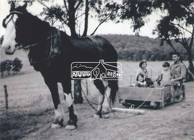
Photograph, Stokes family with horse and sled, Nyora Road, Eltham, c.1950, 1950c
... By chance he met Arthur Bird of Bird Orchard (bounded by Pitt Street, Eucalyptus Road and Wattle Grove) and they got talking over their common interest. ...By chance he met Arthur Bird of Bird Orchard (bounded by Pitt Street, Eucalyptus Road and Wattle Grove) and they got talking over their common interest. ...Taken from outside the family home on the southest corner of the intersection of Nyora Road and Pitt Street with Eucalyptus Road, looking northeast across the Stokes Orchard Frank Stokes with children, Dorothy (left), Beryl and David Frank Stokes first traveled to the district by train in 1944 to find land with the intention to establish an orchard. By chance he met Arthur Bird of Bird Orchard (bounded by Pitt Street, Eucalyptus Road and Wattle Grove) and they got talking over their common interest. Arthur put Frank up for the night and pointed out the land, part of Crown Allotment 15, Section 5, Parish of Nillumbik (CA15) somewhat diagonally opposite Bird Orchard. Frank bought the land and for the next two years would travel by train from Melbourne to Eltham every weekend establishing Stokes Orchard and building a home for his family, which they eventually moved into in 1946. In the mid 1970s the Shire of Eltham divided the orchard up into numerous rate-able parcel lots, which became affordable for Frank. As a consequence Stokes Orchard was turned into a housing development by Macquarie Builders and marketed as the Stokes Orchard Estate in two stages; Stage 1 encompassing Scarlet Ash Court, Ironbark Close and Peppermint Grove bounded by Nyora and Eucalyptus roads c.1976 and Stage 2 encompassing Stokes Place, Orchard Way, The Crest and The Lookout bound by Nyora and Diosma roads c.1979. The development of Orchard Way, The Crest and The Lookout did not proceed as planned due to the lack of the sewer along Diosma Road and so many of the proposed lots were incorporated into five-acre parcels instead.Representative of the orchard growing areas of ElthamDigital file only - Digitised by EDHS from a scrapbook (containing commercially printed photos of digital scans) on loan from Beryl Bradbury (nee Stokes), daughter of Frank Stokes.1950, beryl bradbury (nee stokes), beryl bradbury (nee stokes) collection, david stokes, dorothy stokes, eltham, frank stokes, horse, nyora road, sled, stokes orchard -
 Eltham District Historical Society Inc
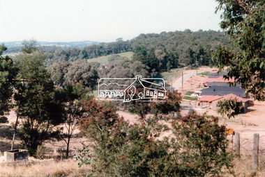
Photograph, Looking south towards Nyora Road, Eltham, 1977, 1977
... By chance he met Arthur Bird of Bird Orchard (bounded by Pitt Street, Eucalyptus Road and Wattle Grove) and they got talking over their common interest. ...By chance he met Arthur Bird of Bird Orchard (bounded by Pitt Street, Eucalyptus Road and Wattle Grove) and they got talking over their common interest. ...Viewed from near the end of Stokes Place where the linear reserve now runs between 8 and 9 Stokes Place just visible through trees in foreground, 24 Nyora with red roof is the first house in middle of view. Frank Stokes first traveled to the district by train in 1944 to find land with the intention to establish an orchard. By chance he met Arthur Bird of Bird Orchard (bounded by Pitt Street, Eucalyptus Road and Wattle Grove) and they got talking over their common interest. Arthur put Frank up for the night and pointed out the land, part of Crown Allotment 15, Section 5, Parish of Nillumbik (CA15) somewhat diagonally opposite Bird Orchard. Frank bought the land and for the next two years would travel by train from Melbourne to Eltham every weekend establishing Stokes Orchard and building a home for his family, which they eventually moved into in 1946. In the mid 1970s the Shire of Eltham divided the orchard up into numerous rate-able parcel lots, which became affordable for Frank. As a consequence Stokes Orchard was turned into a housing development by Macquarie Builders and marketed as the Stokes Orchard Estate in two stages; Stage 1 encompassing Scarlet Ash Court, Ironbark Close and Peppermint Grove bounded by Nyora and Eucalyptus roads c.1976 and Stage 2 encompassing Stokes Place, Orchard Way, The Crest and The Lookout bound by Nyora and Diosma roads c.1979. The development of Orchard Way, The Crest and The Lookout did not proceed as planned due to the lack of the sewer along Diosma Road and so many of the proposed lots were incorporated into five-acre parcels instead.Housing development in Eltham as an extension to the Woodridge EstateDigital file only - Digitised by EDHS from a scrapbook (containing commercially printed photos of digital scans) on loan from Beryl Bradbury (nee Stokes), daughter of Frank Stokes.1977, beryl bradbury (nee stokes) collection, nyora road, stokes orchard estate, stokes place -
 Eltham District Historical Society Inc
Photograph, Stokes Place, Eltham, July 1977, July 1977
... By chance he met Arthur Bird of Bird Orchard (bounded by Pitt Street, Eucalyptus Road and Wattle Grove) and they got talking over their common interest. ...By chance he met Arthur Bird of Bird Orchard (bounded by Pitt Street, Eucalyptus Road and Wattle Grove) and they got talking over their common interest. ...Viewed from near the end of Stokes Place where the linear reserve now runs between 8 and 9 Stokes Place looking slightly east of south towards Nyora Road. The new Christian Church on Nyora now the Baptist Church visible in middle view. Frank Stokes first traveled to the district by train in 1944 to find land with the intention to establish an orchard. By chance he met Arthur Bird of Bird Orchard (bounded by Pitt Street, Eucalyptus Road and Wattle Grove) and they got talking over their common interest. Arthur put Frank up for the night and pointed out the land, part of Crown Allotment 15, Section 5, Parish of Nillumbik (CA15) somewhat diagonally opposite Bird Orchard. Frank bought the land and for the next two years would travel by train from Melbourne to Eltham every weekend establishing Stokes Orchard and building a home for his family, which they eventually moved into in 1946. In the mid 1970s the Shire of Eltham divided the orchard up into numerous rate-able parcel lots, which became affordable for Frank. As a consequence Stokes Orchard was turned into a housing development by Macquarie Builders and marketed as the Stokes Orchard Estate in two stages; Stage 1 encompassing Scarlet Ash Court, Ironbark Close and Peppermint Grove bounded by Nyora and Eucalyptus roads c.1976 and Stage 2 encompassing Stokes Place, Orchard Way, The Crest and The Lookout bound by Nyora and Diosma roads c.1979. The development of Orchard Way, The Crest and The Lookout did not proceed as planned due to the lack of the sewer along Diosma Road and so many of the proposed lots were incorporated into five-acre parcels instead.Housing development in Eltham as an extension to the Woodridge EstateDigital file only - Digitised by EDHS from a scrapbook (containing commercially printed photos of digital scans) on loan from Beryl Bradbury (nee Stokes), daughter of Frank Stokes.1977-07, beryl bradbury (nee stokes) collection, eltham, eltham christian church, stokes orchard estate, stokes place -
 Eltham District Historical Society Inc
Photograph, Stokes family, Nyora Road, Eltham, c.1952, 1952c
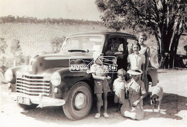
... By chance he met Arthur Bird of Bird Orchard (bounded by Pitt Street, Eucalyptus Road and Wattle Grove) and they got talking over their common interest. ...By chance he met Arthur Bird of Bird Orchard (bounded by Pitt Street, Eucalyptus Road and Wattle Grove) and they got talking over their common interest. ...Taken from outside the family home on the southest corner of the intersection of Nyora Road and Pitt Street with Eucalyptus Road, looking northeast across the Stokes Orchard L-R: David, Howard, Beryl (kneeling), Dorothy and Gladys Stokes with Gladys's mother sitting in Gladys's father's car with Spot the dog, Nyora Road, Eltham, c.1952 Frank Stokes first traveled to the district by train in 1944 to find land with the intention to establish an orchard. By chance he met Arthur Bird of Bird Orchard (bounded by Pitt Street, Eucalyptus Road and Wattle Grove) and they got talking over their common interest. Arthur put Frank up for the night and pointed out the land, part of Crown Allotment 15, Section 5, Parish of Nillumbik (CA15) somewhat diagonally opposite Bird Orchard. Frank bought the land and for the next two years would travel by train from Melbourne to Eltham every weekend establishing Stokes Orchard and building a home for his family, which they eventually moved into in 1946. In the mid 1970s the Shire of Eltham divided the orchard up into numerous rate-able parcel lots, which became affordable for Frank. As a consequence Stokes Orchard was turned into a housing development by Macquarie Builders and marketed as the Stokes Orchard Estate in two stages; Stage 1 encompassing Scarlet Ash Court, Ironbark Close and Peppermint Grove bounded by Nyora and Eucalyptus roads c.1976 and Stage 2 encompassing Stokes Place, Orchard Way, The Crest and The Lookout bound by Nyora and Diosma roads c.1979. The development of Orchard Way, The Crest and The Lookout did not proceed as planned due to the lack of the sewer along Diosma Road and so many of the proposed lots were incorporated into five-acre parcels instead.Representative of the orchard growing areas of ElthamDigital file only - Digitised by EDHS from a scrapbook (containing commercially printed photos of digital scans) on loan from Beryl Bradbury (nee Stokes), daughter of Frank Stokes.1948-1951 vauxhall velox, 1948-1951 vauxhall wyvern, 1952, beryl bradbury (nee stokes), beryl bradbury (nee stokes) collection, david stokes, dorothy stokes, eltham, gladys stokes, nyora road, spot (dog), stokes orchard -
 Eltham District Historical Society Inc
Photograph, Unidentified Shillinglaw Family Female, 1911
... She married Arthur Edward Bird however she is a generation younger and the dates do not fit. ...She married Arthur Edward Bird however she is a generation younger and the dates do not fit. ...The back of the photo is inscribed "To dear Lizzie with love and best wishes from Nellie, Xmas 1911" - Lizzie being Elizabeth Ann Shillinglaw, daughter of Phillip and Sarah Shillinglaw born 1879. The woman in the photo appears to be aged approximately 40 years and is dressed and with a hair style typical of the fashion of 1911. This would make her birth year around the early 1870s. The only Nellie present in the family tree as currently understood is Helen (Nellie) Lyon born 1897 who came to Eltham from Mildura with her mother and brothers in 1913. She married Arthur Edward Bird however she is a generation younger and the dates do not fit. The only other known Nell is Ellen May Bird, daughter of George and Janet Bird, born 1892 so she too is a generation too young. "To dear Lizzie with love and best wishes from Nellie, Xmas 1911" on reversemarg ball collection, 1911, elizabeth (lizzie) ann shillinglaw (1879-1972), female shillinglaw 1, nellie, unknown -
 Eltham District Historical Society Inc
Photograph, The Stokes family home and orchard blanketed with snow, corner Nyora and Eucalyptus roads, Eltham, Winter 1951, 1951
... By chance he met Arthur Bird of Bird Orchard (bounded by Pitt Street, Eucalyptus Road and Wattle Grove) and they got talking over their common interest. ...By chance he met Arthur Bird of Bird Orchard (bounded by Pitt Street, Eucalyptus Road and Wattle Grove) and they got talking over their common interest. ...Taken from outside the family home on the southest corner of the intersection of Nyora Road and Pitt Street with Eucalyptus Road. Frank Stokes first traveled to the district by train in 1944 to find land with the intention to establish an orchard. By chance he met Arthur Bird of Bird Orchard (bounded by Pitt Street, Eucalyptus Road and Wattle Grove) and they got talking over their common interest. Arthur put Frank up for the night and pointed out the land, part of Crown Allotment 15, Section 5, Parish of Nillumbik (CA15) somewhat diagonally opposite Bird Orchard. Frank bought the land and for the next two years would travel by train from Melbourne to Eltham every weekend establishing Stokes Orchard and building a home for his family, which they eventually moved into in 1946. Marjorie North remembered well the winter of 1951, when she took children, including son John together with the Shallard and Squire children “in the Austin A40 up the Main Rd., Eltham to farmer Bell’s property alongside the Eltham College. They were able to make a snow man and throw snowballs. (Diamond Valley News, August 5, 1986.p.42) In the mid 1970s the Shire of Eltham divided the orchard up into numerous rate-able parcel lots, which became affordable for Frank. As a consequence Stokes Orchard was turned into a housing development by Macquarie Builders and marketed as the Stokes Orchard Estate in two stages; Stage 1 encompassing Scarlet Ash Court, Ironbark Close and Peppermint Grove bounded by Nyora and Eucalyptus roads c.1976 and Stage 2 encompassing Stokes Place, Orchard Way, The Crest and The Lookout bound by Nyora and Diosma roads c.1979. The development of Orchard Way, The Crest and The Lookout did not proceed as planned due to the lack of the sewer along Diosma Road and so many of the proposed lots were incorporated into five-acre parcels instead.Representative of the orchard growing areas of Eltham. One of the rare times it has snowed in Eltham.Digital file only - Digitised by EDHS from a scrapbook (containing commercially printed photos of digital scans) on loan from Beryl Bradbury (nee Stokes), daughter of Frank Stokes.1951, beryl bradbury (nee stokes) collection, eltham, nyora road, eucalyptus road, snow, stokes family home -
 Eltham District Historical Society Inc
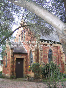
Photograph - Digital Photograph, Marguerite Marshall, Uniting Church, Main Road, Eltham, 19 August 2008
... Some of the many church members who have had an outstanding impact on the wider community include Philip Shillinglaw, farmer and poet, and Arthur Bird (after whom the Arthur Bird Reserve is named), a pioneer orchardist and the Sunday School Superintendent for 33 years. ...Some of the many church members who have had an outstanding impact on the wider community include Philip Shillinglaw, farmer and poet, and Arthur Bird (after whom the Arthur Bird Reserve is named), a pioneer orchardist and the Sunday School Superintendent for 33 years. ...Eltham's original Wesleyan Methodist Church Covered under Heritage Overlay, Nillumbik Planning Scheme. Published: Nillumbik Now and Then / Marguerite Marshall 2008; photographs Alan King with Marguerite Marshall.; p97 The pretty Uniting Church building at the corner of John and Main Roads Eltham has served the community since 1881.1 Originally called the Eltham Wesleyan Church, the church became the Eltham Methodist Church in 1902, the year it united with the Primitive Methodists.2 As the church community developed, influencing and being influenced by the wider community, its buildings changed accordingly. Eltham Wesleyans first worshiped together in 1850 at the home of William and Mary Crozier on 24 acres (9.7ha) bounded by Mount Pleasant Road and Pitt Street. From 1855 the Wesleyans worshipped in a slab-and-bark hut; then in 1858 in a chapel on Henry Street close to Maria Street (now Main Road). Meanwhile, in 1860, the Primitive Methodists opened a brick chapel at the corner of Susan and Bridge Streets. The John Street building – in the Early English Gothic style with biochrome brick window frames, buttress heads and pinnacle – was designed by architects Crouch and Wilson. Church member George Stebbing built the church as he did Eltham’s St Margaret’s Anglican Church and Shillinglaw Cottage. The Church Honour Roll is a poignant reminder of how church members have served the wider community: 27 members enlisted and 11 died in World War One. Despite the Great Depression, 1931 was a time of expansion for the church. Its red-brick hall was opened by prominent Methodist and philanthropist F J Cato of the Moran and Cato Grocery chain. The hall enabled the church to attract people from outside through activities like its gymnasium – with 40 boys and youth participating – and the girls’ callisthenics club, which competed at the Ballarat South Street Competitions. The church also held concerts, bazaars, picnics and sports, with badminton and tennis played on the church court at 23 John Street. Two stained-glass windows commemorate tragic events. A dove representing the Holy Spirit and Comforter marked the death in 1936 of member Effie Lowerson from scarlet fever at 14 years. The other depicting the Biblical story A sower went forth to sow, commemorates Ross Gangell, who died in 1961 at 23 years of a rare blood condition. Eltham’s population expanson resulted in the growth of the church and an extension in 1971, designed by member and architect Colin Jones. The church was linked to the hall and additions included a foyer, vestry, meeting room and toilets. The design reflected the Eltham style of the time, with its simplicity, extensive clear glass, reused baked clay-bricks from the 1881 church, heavy ceiling beams and solomite (compressed straw) ceiling. On June 26, 1977 the church became part of the new Uniting Church in Australia consisting of the former Methodist and Congregational and most of the Presbyterian Churches. In 1981 membership peaked at 159 – about 20 years after most Protestant churches – and continued to reach out to the wider community.3 In 1987, 147 children attended Selihoo, the weekly after-school program organised with St Margaret’s Anglican Church. From 1993, the church with other local churches, participated in LINC (Love in the Name of Christ), helping the wider community in various ways including babysitting, transport, gardening and visiting. Despite such initiatives, church numbers declined, and on June 23, 1996, the church merged with the Montmorency Uniting Church.4 However, the church continued to proclaim its message of love in community service and strong social justice action, such as in Jubilee 2000, supporting debt relief to the world’s 45 poorest countries. Some of the many church members who have had an outstanding impact on the wider community include Philip Shillinglaw, farmer and poet, and Arthur Bird (after whom the Arthur Bird Reserve is named), a pioneer orchardist and the Sunday School Superintendent for 33 years. Others were: the Rev Dr Cliff Wright, who established the Methodist Youth Fellowship and was prominent in the World Council of Churches, the Rev Brian Howe, who became Deputy Prime Minister and Tim Marshall, awarded the Order of Australia in 2000 for his work on salinity.This collection of almost 130 photos about places and people within the Shire of Nillumbik, an urban and rural municipality in Melbourne's north, contributes to an understanding of the history of the Shire. Published in 2008 immediately prior to the Black Saturday bushfires of February 7, 2009, it documents sites that were impacted, and in some cases destroyed by the fires. It includes photographs taken especially for the publication, creating a unique time capsule representing the Shire in the early 21st century. It remains the most recent comprehenesive publication devoted to the Shire's history connecting local residents to the past. nillumbik now and then (marshall-king) collection, eltham uniting church, eltham methodist church -
 Eltham District Historical Society Inc
Film - Video (DVD), Frank Stokes, Stokes Family, 1950-1977
... He was helped and advised by Arthur Bird who farmed the neighbouring orchard. ...He was helped and advised by Arthur Bird who farmed the neighbouring orchard. ...Various family scenes taken from outside the family home on the southeast corner of the intersection of Nyora Road and Pitt Street with Eucalyptus Road. Also, scenes of the Stokes Orchard and equipment used, construction of water reservoir at the end of Nyora Road near Reynolds Road and Diosma Road as well as early stages of the Stokes Orchard housing development. Frank Stokes worked as a qualified accountant at Kennons leather factory in Burnley, while living at 1 Thomas Street, Mitcham. He suffered from migraines and wanted to go back to the land (he had previously worked on farms and orchards since coming to Australia in 1926 both in WA and Vic.). He first travelled to the district by train in July 1942 to find land with the intention to establish an orchard. By chance he met Arthur Bird of Bird Orchard (bounded by Pitt Street, Eucalyptus Road and Wattle Grove) and they got talking over their common interest. Arthur put Frank up for the night and pointed out the land, 158 acres- Taylor Estate- £900, part of Crown Allotment 15, Section 5, Parish of Nillumbik (CA15) somewhat diagonally opposite Bird Orchard. He applied through the Riverina Agency to purchase the land who in turn had to get permission from Canberra to sell as there was a new government regulation banning land sales except for immediate production. He obtained a loan on his Mitcham house of £600 @ 5% and paid £450 deposit with quarterly payments of £15 over 5 years. The title to the property was issued May 15, 1946. He was helped and advised by Arthur Bird who farmed the neighbouring orchard. Early 1943 he took possession and would catch the train out to Eltham on Fridays after work and began building a hut for shelter and to lock up tools. He was able to pay a neighbour (Hawkins) to help with clearing and fencing 25 acres and with a horse and single furrowed plow, planted approximately 2,500 fruit trees - cherries, peaches, plums, almonds, pears, apricots and lemons as well as a few apples and oranges; a massive job. A huge problem was hares and rabbits eating all the new buds off the tiny trees. As well as laying poison he painted the trees with a mixture of cow manure and lime. Often working by moonlight. It was extremely difficult to get wire and wire netting because of the war but after much effort he obtained a permit from the Agricultural Department for supplies in March 1944. In February 1945 he applied for a permit to build a “packing shed” as no house building allowed. It was to be 33 feet x 21 feet and cost £312. Constructed mostly from second-hand materials, which was hard to obtain, especially iron for roofing. Frank finished work at Kennons October 31, 1945, and in March 1946 he sold the Mitcham house for £1230 plus £170 for furniture. The family of five then moved into a very unfinished at Eltham, which was a struggle to weatherproof. Eventually rooms were divided off and lined with hessian bags and whitewashed. Their income was firewood (cut and sold), selling rockery stones and cut sweet bursaria. (It was discovered during the 1940s that Bursaria contained the sunscreen compound Aesculin. The RAAF utilised this compound from Bursaria during WW2 for pilots and gunners.) The orchard’s first fruit sale was a 1/2 case of Le Vanq peaches in December 1947 - 8 shillings. In 1956 plans for house were drawn and Glen Iris bricks purchased (1956 Olympic Rings variant). The building of the house commenced in 1957 - 12 feet of original packing shed removed – and was completed in 1959. Water was connected from newly built pressure storage on the property at the end of 1959 and the electricity connection for the first time at 3pm on April 29, 1960. In the mid-1970s the Shire of Eltham divided the orchard up into numerous rate-able parcel lots, which became unaffordable for Frank. Consequently, Stokes Orchard was turned into a housing development by Macquarie Builders and marketed as the Stokes Orchard Estate in two stages; Stage 1 encompassing Scarlet Ash Court, Ironbark Close and Peppermint Grove bounded by Nyora and Eucalyptus roads c.1976 and Stage 2 encompassing Stokes Place, Orchard Way, The Crest and The Lookout bound by Nyora and Diosma roads c.1979. The development of Orchard Way, The Crest and The Lookout did not proceed as planned due to the lack of the sewer along Diosma Road and so many of the proposed lots were incorporated into five-acre parcels instead. With the arrival of the sewer along Diosma Road many years later, most of these five-acre parcels have since been subdivided many times.Representative of the orchard growing areas of ElthamMP4 00:24:39; 426MB Digital file only - Digitised by EDHS from a DVD copy on loan from Beryl Bradbury (nee Stokes), daughter of Frank Stokes. 24 min duration compilation of home movie Super 8mm film shot by Frank Stokes brother-in-law.beryl bradbury (nee stokes) collection, frank stokes, nyora road, stokes orchard, stokes orchard estate, stokes place, video recording -
 Eltham District Historical Society Inc
Photograph - Aerial Photograph, Landata, Eltham; Crown Allotment 15, Section 5, Parish of Nillumbik (Stokes Orchard Estate), Dec. 1945
... Stokes was assisted and advised by Arthur Bird who farmed the neighbouring orchard. ...Stokes was assisted and advised by Arthur Bird who farmed the neighbouring orchard. ...Centred on present day Diosma Rd, Stokes Pl, Nyora Rd and Eucalyptus Rd Historic Aerial Imagery Source: Landata.vic.gov.au Aerial Photo Details: Project No :5 Project : MELBOURNE AND METROPOLITAN AREA PROJECT Run : 36 Frame : 60546 Date : 12/1945 Film Type : B/W Camera : EAG4 Flying Height : 10200 Scale : 6000 Film Number : 195 GDA2020 : 37°42'47"S, 145°09'56"E MGA2020 : 338306, 5824438 (55) Melways : 22 C4 (ed. 42) A History of the Development of Crown Allotment 15, Section 5, Parish of Nillumbik – Stokes Orchard Crown Allotment 15, Section 5, Parish of Nillumbik (CA15) is a square allotment of 158 acres or approximately a quarter of a square mile. It lies just beyond the eastern end of Pitt Street, south of Nyora Road to the northern end of Eucalyptus Road and extends east from Eucalyptus Road to Reynolds Road. The topography of CA15 is generally steep, sloping up to a hill near the centre of the land, the ridgeline passing through the properties along the southern side of Diosma Road. Eucalyptus Road is a straight north-south road with its northern end at the north west corner of CA15. Until the end of the 1970s this road was an un-named Government Road and was largely not open to traffic. With residential development in the 1970s the road was constructed, and the council allocated the name obviously in recognition of the predominant species of the local bushland. CA15 was purchased from the Crown by George D’Arley Boursiquot, a prominent Melbourne printer, on 28th October 1852. On November 23, 1922, former Member for Gippsland and Melbourne Real Estate Agent, Hubert Patrick Keogh purchased the allotment then sold it March 13, 1925, to local farmer, Robert David Taylor, a former Shire of Eltham Councillor (1911-1920) and Shire President (1919). Taylor had extensive land holdings stretching west towards Bible Street and Main Road. The Taylor home was situated at the top of the hill in Bible Street at present day 82 Bible Street. At the time of Taylor’s purchase in 1925, CA15 was subdivided into 48 lots that could be described as small rural properties or large residential lots. A typical lot size was one hectare or 2.5 acres. The subdivision created two roads, Nyora Road, and Diosma Road, each following an irregular alignment between Eucalyptus and Reynolds Roads. However, the lots were not sold off separately nor were the roads constructed. The land effectively remained as one parcel for many further years. Robert David Taylor died November 30, 1934, and probate was granted to his son of the same name, Robert David Taylor of Bible Street, Salesman and William McLelland Vance Taylor of 73 Emmeline Street, Northcote, Clerk, with the transfer of the land into their names on July 8, 1935. Frank Stokes worked as a qualified accountant at Kennons leather factory in Burnley, while living at 1 Thomas Street, Mitcham. He suffered from migraines and wanted to return to working the land (he had previously worked on farms and orchards since coming to Australia from England in 1926, both in WA and Vic.). He first travelled to the district by train in July 1942 to find land with the intention to establish an orchard. By chance he met Arthur Bird of Bird Orchard (bounded by Pitt Street, Eucalyptus Road, and Wattle Grove) and they got talking over their common interest. Arthur put Frank up for the night and pointed out the land, 158 acres- part of the Taylor Estate- £900, Crown Allotment 15, Section 5, Parish of Nillumbik (CA15) somewhat diagonally opposite Bird Orchard. Stokes applied through the Riverina Agency to purchase the land who in turn applied for permission from Canberra to sell as there was a new government regulation introduced during the Second World War banning land sales except for immediate production. Stokes obtained a loan on his Mitcham house of £600 @ 5% and paid £450 deposit with quarterly payments of £15 spread over 5 years. Stokes was assisted and advised by Arthur Bird who farmed the neighbouring orchard. In early 1943 Stokes took possession and would catch the train out to Eltham on Fridays after work and began building a hut on the corner of Nyora Road and the Government Road (Eucalyptus Road) for shelter and to lock up tools. He established an orchard on the central western part of the land through the centre of which ran a natural waterway (part of the present-day linear park) and was able to pay a neighbour (Hawkins) to help with clearing and fencing 25 acres, and with a horse and single furrowed plough, planted approximately 2,500 fruit trees - cherries, peaches, plums, almonds, pears, apricots and lemons as well as a few apples and oranges; a massive task. Aerial photographs from the 1940s through to the 1990s clearly show the orchard with most of the larger CA15 site remaining as natural bushland. A huge problem was hares and rabbits eating all the new buds off the tiny trees. As well as laying poison he painted the trees with a mixture of cow manure and lime, often working by moonlight. Procurement of wire and wire netting was difficult because of the war but after much effort he obtained a permit from the Agricultural Department for supplies in March 1944. In February 1945 Stokes applied for a permit to build a “packing shed” as no house building was allowed. It was to be 33 feet x 21 feet and cost £312. It was constructed mostly from second-hand materials, which were hard to obtain, especially iron for roofing. Stokes finished work at Kennons on October 31, 1945, and in March 1946 he sold the family home at Mitcham for £1,230 plus £170 for furniture. On May 15, 1946, title to the CA15 property was issued to Frank Howard Alfred Stokes, Orchardist and Gladys Ethel Stokes, Married Woman, both of Pitt Street, Eltham. The family of five then moved into the very unfinished “packing shed” at Eltham, which was a struggle to weatherproof. Eventually rooms were divided off and lined with hessian bags and whitewashed. Their income was firewood (cut and sold), selling rockery stones and cut Sweet Bursaria. (It was discovered during the 1940s that Sweet Bursaria contained the sunscreen compound Aesculin. The RAAF utilised this compound from Sweet Bursaria during WW2 for pilots and gunners.) The orchard’s first fruit sale was a half-case of Le Vanq peaches in December 1947 for the price of 8 shillings. In 1956 plans for house were drawn and Glen Iris bricks purchased (1956 Olympic Rings variant). The building of the house commenced in 1957 - 12 feet of original packing shed was removed – and was completed in 1959. Water was connected from newly built pressure storage on the property at the end of 1959 and the electricity connection for the first time at 3pm on April 29, 1960. The house remains to present day (somewhat modified) at 1 Nyora Road, home to Nyora Studio Gallery. On occasions, spare remnants of the 1956 bricks have been known to be unearthed in gardens on the estate as they were utilised by Frank Stokes to fill in rabbit holes. On May 26, 1950, a parcel of land was compulsorily acquired by the Melbourne and Metropolitan Board of Works on the hilltop to establish an easement for a high-level service reservoir to augment Eltham’s water supply. The project also included pipe tracks for the necessary water mains. The reservoir has now been superseded by higher level water tanks east of Reynolds Road and its former site is now a public reserve. On November 27, 1964, the State Electricity Commission served notice to compulsorily acquire a further parcel through the eastern part of the land for a major electricity transmission line that augmented supply from the La Trobe Valley to Melbourne. The easement was registered February 11, 1966. The easement was widened July 18, 1969 for a second transmission line to be constructed. In 1971 Melbourne Metropolitan Planning Scheme amendments adopted Nyora Road as the boundary between a residential zone to the north and a rural zone to the south. This determined the future development of the land. In the mid-1970s the Shire of Eltham divided the orchard into numerous rate-able parcel lots, the 48 lots having been established in 1925 and the subsequent rates assessment proved unsustainable for Stokes. He commenced selling lots outside the boundary of the orchard, north of Diosma and South of Nyora. However shortly later the land between Nyora and Diosma Roads and west of the electricity easement was sold and subdivided into residential lots, a housing development by Macquarie Builders and marketed as the Stokes Orchard Estate. New streets were created, and most were named after trees, although one, Stokes Place, commemorates the former owners. The development was undertaken in two stages; Stage 1 (1975) encompassing Scarlet Ash Court, Ironbark Close and Peppermint Grove bounded by Nyora and Eucalyptus roads and Stage 2 (1978) encompassing Stokes Place, Orchard Way, The Crest and The Lookout bound by Nyora and Diosma roads. The developer, Macquarie Builders went bankrupt shortly after the release of Stage 2 leaving many purchasers to fend for themselves and arrange for their own independent builders. There were also difficulties with sewerage for the land immediately south of Diosma Road and so the conventional residential lots were abandoned in favour of larger lots. The development of Orchard Way, The Crest and The Lookout did not proceed as planned and the proposed lots were incorporated into five-acre parcels instead. These included a low-density group housing development by the Graves family and the award winning Choong House (1983) with Gordon Ford developed garden immediately next door situated on the ridge of the hill nestled amongst the original bush, Eucalypt trees and Sweet Bursaria. In 1994, Nillumbik Shire Council applied Significant Environment and Significant Landscape overlays upon the properties on the south side of Diosma Road to ensure protection of this natural bush garden environment. With the arrival of the sewer along Diosma Road in the 1990s, most of these five-acre parcels have since been subdivided multiple times. The Choong house presently sits on a 2.7-acre property, which in 2022 Nillumbik Council nominated for Cultural Significance Heritage protection and is considered potentially significant at State level. The Stokes family were also associated with the Eltham Christian Church. In the 1970s this church had met in temporary premises in Eltham. Lots of the original 1925 subdivision remained south of Nyora Road and a number of these lots were utilized for the Eltham Christian School, which was established by the Eltham Christian Church in 1981. The school operated on this site until 2000. The premises are now used by The Vine Baptist Church. By the mid-1980s the whole of CA15 had been developed for residential and school purposes, except for the sections north of Diosma Road and between the transmission lines and Reynolds Road. Sewerage issues had been resolved for the section north of Diosma Road and in 1987 it was in the process of being subdivided into residential lots. The development coincided with the discovery of colonies of the rare and endangered Eltham Copper Butterfly on the site. This resulted in a community and political campaign to save the butterfly habitat. With the co-operation of the land developer the subdivision was altered to create two bushland reserves in the critical butterfly habitat areas. In the late 1980s the State Government was investigating options for establishing a metropolitan ring road link between Diamond Creek and Ringwood. The chosen route was adjacent to Reynolds Road and so this created a freeze on development of CA15 between Reynolds Road and the electricity easement. The ring road proposal was eventually abandoned, and this part of the land was subdivided into low density residential lots. Diosma Road has been discontinued at the electricity easement and the eastern part incorporated into View Mount Court with access from Reynolds Road. The whole of CA15 has now been developed for residential or associated purposes, ranging from conventional density to quite low density south of Nyora Road. Some remnants of the orchard remain, a few cherry trees on the Graves property and a lone apple tree in Stokes Place. The butterfly reserves comprise significant areas of remnant bushland. Linear reserves through the estate link with central Eltham via the Woodridge linear reserve and with Research along the electricity easement. CA15 as it exists today has a complicated history of rural use, Government acquisition, urban development, and community action. References: • “Stokes Orchard, an incomplete history”; Russell Yeoman with Doug Orford • Correspondence, Beryl Bradbury (nee Stokes) • Aerial Photographs, 1931-1991, Landata (landata.vic.gov.au) • Certificate of Title, Vol. 4930 Fol. 985900 • Plan Number LP 10859 aerial photo, diosma road, eltham copper butterfly, eucalyptus road, ironbark close, nyora road, peppermint grove, peter & elizabeth pidgeon collection, power transmission lines, reynolds road, scarlet ash court, stokes orchard estate, stokes place, woodridge estate, frank stokes -
 Eltham District Historical Society Inc
Photograph - Aerial Photograph, Landata, Eltham; Crown Allotment 15, Section 5, Parish of Nillumbik (Stokes Orchard Estate), Nov. 1931
... Stokes was assisted and advised by Arthur Bird who farmed the neighbouring orchard. ...Stokes was assisted and advised by Arthur Bird who farmed the neighbouring orchard. ...Centred over present day Reynolds Road and Mount Pleasant Road, Eltham (including Diosma Rd, Stokes Pl, Nyora Rd and Eucalyptus Rd) Historic Aerial Imagery Source: Landata.vic.gov.au Aerial Photo Details: Project No :1931 Project : MALDON PRISON Run : 21 Frame : 3160 Date : 11/1931 Film Type : B/W Camera : F8 Flying Height : 11000 Scale : 18860 Film Number : 60 GDA2020 : 37°43'31"S, 145°10'20"E MGA2020 : 338912, 5823086 (55) Melways : 22 E8 (ed. 42) A History of the Development of Crown Allotment 15, Section 5, Parish of Nillumbik – Stokes Orchard Crown Allotment 15, Section 5, Parish of Nillumbik (CA15) is a square allotment of 158 acres or approximately a quarter of a square mile. It lies just beyond the eastern end of Pitt Street, south of Nyora Road to the northern end of Eucalyptus Road and extends east from Eucalyptus Road to Reynolds Road. The topography of CA15 is generally steep, sloping up to a hill near the centre of the land, the ridgeline passing through the properties along the southern side of Diosma Road. Eucalyptus Road is a straight north-south road with its northern end at the north west corner of CA15. Until the end of the 1970s this road was an un-named Government Road and was largely not open to traffic. With residential development in the 1970s the road was constructed, and the council allocated the name obviously in recognition of the predominant species of the local bushland. CA15 was purchased from the Crown by George D’Arley Boursiquot, a prominent Melbourne printer, on 28th October 1852. On November 23, 1922, former Member for Gippsland and Melbourne Real Estate Agent, Hubert Patrick Keogh purchased the allotment then sold it March 13, 1925, to local farmer, Robert David Taylor, a former Shire of Eltham Councillor (1911-1920) and Shire President (1919). Taylor had extensive land holdings stretching west towards Bible Street and Main Road. The Taylor home was situated at the top of the hill in Bible Street at present day 82 Bible Street. At the time of Taylor’s purchase in 1925, CA15 was subdivided into 48 lots that could be described as small rural properties or large residential lots. A typical lot size was one hectare or 2.5 acres. The subdivision created two roads, Nyora Road, and Diosma Road, each following an irregular alignment between Eucalyptus and Reynolds Roads. However, the lots were not sold off separately nor were the roads constructed. The land effectively remained as one parcel for many further years. Robert David Taylor died November 30, 1934, and probate was granted to his son of the same name, Robert David Taylor of Bible Street, Salesman and William McLelland Vance Taylor of 73 Emmeline Street, Northcote, Clerk, with the transfer of the land into their names on July 8, 1935. Frank Stokes worked as a qualified accountant at Kennons leather factory in Burnley, while living at 1 Thomas Street, Mitcham. He suffered from migraines and wanted to return to working the land (he had previously worked on farms and orchards since coming to Australia from England in 1926, both in WA and Vic.). He first travelled to the district by train in July 1942 to find land with the intention to establish an orchard. By chance he met Arthur Bird of Bird Orchard (bounded by Pitt Street, Eucalyptus Road, and Wattle Grove) and they got talking over their common interest. Arthur put Frank up for the night and pointed out the land, 158 acres- part of the Taylor Estate- £900, Crown Allotment 15, Section 5, Parish of Nillumbik (CA15) somewhat diagonally opposite Bird Orchard. Stokes applied through the Riverina Agency to purchase the land who in turn applied for permission from Canberra to sell as there was a new government regulation introduced during the Second World War banning land sales except for immediate production. Stokes obtained a loan on his Mitcham house of £600 @ 5% and paid £450 deposit with quarterly payments of £15 spread over 5 years. Stokes was assisted and advised by Arthur Bird who farmed the neighbouring orchard. In early 1943 Stokes took possession and would catch the train out to Eltham on Fridays after work and began building a hut on the corner of Nyora Road and the Government Road (Eucalyptus Road) for shelter and to lock up tools. He established an orchard on the central western part of the land through the centre of which ran a natural waterway (part of the present-day linear park) and was able to pay a neighbour (Hawkins) to help with clearing and fencing 25 acres, and with a horse and single furrowed plough, planted approximately 2,500 fruit trees - cherries, peaches, plums, almonds, pears, apricots and lemons as well as a few apples and oranges; a massive task. Aerial photographs from the 1940s through to the 1990s clearly show the orchard with most of the larger CA15 site remaining as natural bushland. A huge problem was hares and rabbits eating all the new buds off the tiny trees. As well as laying poison he painted the trees with a mixture of cow manure and lime, often working by moonlight. Procurement of wire and wire netting was difficult because of the war but after much effort he obtained a permit from the Agricultural Department for supplies in March 1944. In February 1945 Stokes applied for a permit to build a “packing shed” as no house building was allowed. It was to be 33 feet x 21 feet and cost £312. It was constructed mostly from second-hand materials, which were hard to obtain, especially iron for roofing. Stokes finished work at Kennons on October 31, 1945, and in March 1946 he sold the family home at Mitcham for £1,230 plus £170 for furniture. On May 15, 1946, title to the CA15 property was issued to Frank Howard Alfred Stokes, Orchardist and Gladys Ethel Stokes, Married Woman, both of Pitt Street, Eltham. The family of five then moved into the very unfinished “packing shed” at Eltham, which was a struggle to weatherproof. Eventually rooms were divided off and lined with hessian bags and whitewashed. Their income was firewood (cut and sold), selling rockery stones and cut Sweet Bursaria. (It was discovered during the 1940s that Sweet Bursaria contained the sunscreen compound Aesculin. The RAAF utilised this compound from Sweet Bursaria during WW2 for pilots and gunners.) The orchard’s first fruit sale was a half-case of Le Vanq peaches in December 1947 for the price of 8 shillings. In 1956 plans for house were drawn and Glen Iris bricks purchased (1956 Olympic Rings variant). The building of the house commenced in 1957 - 12 feet of original packing shed was removed – and was completed in 1959. Water was connected from newly built pressure storage on the property at the end of 1959 and the electricity connection for the first time at 3pm on April 29, 1960. The house remains to present day (somewhat modified) at 1 Nyora Road, home to Nyora Studio Gallery. On occasions, spare remnants of the 1956 bricks have been known to be unearthed in gardens on the estate as they were utilised by Frank Stokes to fill in rabbit holes. On May 26, 1950, a parcel of land was compulsorily acquired by the Melbourne and Metropolitan Board of Works on the hilltop to establish an easement for a high-level service reservoir to augment Eltham’s water supply. The project also included pipe tracks for the necessary water mains. The reservoir has now been superseded by higher level water tanks east of Reynolds Road and its former site is now a public reserve. On November 27, 1964, the State Electricity Commission served notice to compulsorily acquire a further parcel through the eastern part of the land for a major electricity transmission line that augmented supply from the La Trobe Valley to Melbourne. The easement was registered February 11, 1966. The easement was widened July 18, 1969 for a second transmission line to be constructed. In 1971 Melbourne Metropolitan Planning Scheme amendments adopted Nyora Road as the boundary between a residential zone to the north and a rural zone to the south. This determined the future development of the land. In the mid-1970s the Shire of Eltham divided the orchard into numerous rate-able parcel lots, the 48 lots having been established in 1925 and the subsequent rates assessment proved unsustainable for Stokes. He commenced selling lots outside the boundary of the orchard, north of Diosma and South of Nyora. However shortly later the land between Nyora and Diosma Roads and west of the electricity easement was sold and subdivided into residential lots, a housing development by Macquarie Builders and marketed as the Stokes Orchard Estate. New streets were created, and most were named after trees, although one, Stokes Place, commemorates the former owners. The development was undertaken in two stages; Stage 1 (1975) encompassing Scarlet Ash Court, Ironbark Close and Peppermint Grove bounded by Nyora and Eucalyptus roads and Stage 2 (1978) encompassing Stokes Place, Orchard Way, The Crest and The Lookout bound by Nyora and Diosma roads. The developer, Macquarie Builders went bankrupt shortly after the release of Stage 2 leaving many purchasers to fend for themselves and arrange for their own independent builders. There were also difficulties with sewerage for the land immediately south of Diosma Road and so the conventional residential lots were abandoned in favour of larger lots. The development of Orchard Way, The Crest and The Lookout did not proceed as planned and the proposed lots were incorporated into five-acre parcels instead. These included a low-density group housing development by the Graves family and the award winning Choong House (1983) with Gordon Ford developed garden immediately next door situated on the ridge of the hill nestled amongst the original bush, Eucalypt trees and Sweet Bursaria. In 1994, Nillumbik Shire Council applied Significant Environment and Significant Landscape overlays upon the properties on the south side of Diosma Road to ensure protection of this natural bush garden environment. With the arrival of the sewer along Diosma Road in the 1990s, most of these five-acre parcels have since been subdivided multiple times. The Choong house presently sits on a 2.7-acre property, which in 2022 Nillumbik Council nominated for Cultural Significance Heritage protection and is considered potentially significant at State level. The Stokes family were also associated with the Eltham Christian Church. In the 1970s this church had met in temporary premises in Eltham. Lots of the original 1925 subdivision remained south of Nyora Road and a number of these lots were utilized for the Eltham Christian School, which was established by the Eltham Christian Church in 1981. The school operated on this site until 2000. The premises are now used by The Vine Baptist Church. By the mid-1980s the whole of CA15 had been developed for residential and school purposes, except for the sections north of Diosma Road and between the transmission lines and Reynolds Road. Sewerage issues had been resolved for the section north of Diosma Road and in 1987 it was in the process of being subdivided into residential lots. The development coincided with the discovery of colonies of the rare and endangered Eltham Copper Butterfly on the site. This resulted in a community and political campaign to save the butterfly habitat. With the co-operation of the land developer the subdivision was altered to create two bushland reserves in the critical butterfly habitat areas. In the late 1980s the State Government was investigating options for establishing a metropolitan ring road link between Diamond Creek and Ringwood. The chosen route was adjacent to Reynolds Road and so this created a freeze on development of CA15 between Reynolds Road and the electricity easement. The ring road proposal was eventually abandoned, and this part of the land was subdivided into low density residential lots. Diosma Road has been discontinued at the electricity easement and the eastern part incorporated into View Mount Court with access from Reynolds Road. The whole of CA15 has now been developed for residential or associated purposes, ranging from conventional density to quite low density south of Nyora Road. Some remnants of the orchard remain, a few cherry trees on the Graves property and a lone apple tree in Stokes Place. The butterfly reserves comprise significant areas of remnant bushland. Linear reserves through the estate link with central Eltham via the Woodridge linear reserve and with Research along the electricity easement. CA15 as it exists today has a complicated history of rural use, Government acquisition, urban development, and community action. References: • “Stokes Orchard, an incomplete history”; Russell Yeoman with Doug Orford • Correspondence, Beryl Bradbury (nee Stokes) • Aerial Photographs, 1931-1991, Landata (landata.vic.gov.au) • Certificate of Title, Vol. 4930 Fol. 985900 • Plan Number LP 10859 aerial photo, diosma road, eltham copper butterfly, eucalyptus road, ironbark close, nyora road, peppermint grove, peter & elizabeth pidgeon collection, power transmission lines, reynolds road, scarlet ash court, stokes orchard estate, stokes place, woodridge estate, frank stokes -
 Eltham District Historical Society Inc
Photograph - Aerial Photograph, Landata, Eltham; Crown Allotment 15, Section 5, Parish of Nillumbik (Stokes Orchard Estate), Jan. 1951
... Stokes was assisted and advised by Arthur Bird who farmed the neighbouring orchard. ...Stokes was assisted and advised by Arthur Bird who farmed the neighbouring orchard. ...Centred on present day Diosma Rd, Stokes Pl, Nyora Rd and Eucalyptus Rd Historic Aerial Imagery Source: Landata.vic.gov.au Aerial Photo Details: Project No :65 Project : MELBOURNE AND METROPOLITAN PROJECT NO. 2 Run : 8 Frame : 71 Date : 01/1951 Film Type : B/W Camera : EAG9 Flying Height : 12200 Scale : 12000 Film Number : 1419 GDA2020 : 37°43'14"S, 145°09'46"E MGA2020 : 338081, 5823608 (55) Melways : 22 C6 (ed. 42) A History of the Development of Crown Allotment 15, Section 5, Parish of Nillumbik – Stokes Orchard Crown Allotment 15, Section 5, Parish of Nillumbik (CA15) is a square allotment of 158 acres or approximately a quarter of a square mile. It lies just beyond the eastern end of Pitt Street, south of Nyora Road to the northern end of Eucalyptus Road and extends east from Eucalyptus Road to Reynolds Road. The topography of CA15 is generally steep, sloping up to a hill near the centre of the land, the ridgeline passing through the properties along the southern side of Diosma Road. Eucalyptus Road is a straight north-south road with its northern end at the north west corner of CA15. Until the end of the 1970s this road was an un-named Government Road and was largely not open to traffic. With residential development in the 1970s the road was constructed, and the council allocated the name obviously in recognition of the predominant species of the local bushland. CA15 was purchased from the Crown by George D’Arley Boursiquot, a prominent Melbourne printer, on 28th October 1852. On November 23, 1922, former Member for Gippsland and Melbourne Real Estate Agent, Hubert Patrick Keogh purchased the allotment then sold it March 13, 1925, to local farmer, Robert David Taylor, a former Shire of Eltham Councillor (1911-1920) and Shire President (1919). Taylor had extensive land holdings stretching west towards Bible Street and Main Road. The Taylor home was situated at the top of the hill in Bible Street at present day 82 Bible Street. At the time of Taylor’s purchase in 1925, CA15 was subdivided into 48 lots that could be described as small rural properties or large residential lots. A typical lot size was one hectare or 2.5 acres. The subdivision created two roads, Nyora Road, and Diosma Road, each following an irregular alignment between Eucalyptus and Reynolds Roads. However, the lots were not sold off separately nor were the roads constructed. The land effectively remained as one parcel for many further years. Robert David Taylor died November 30, 1934, and probate was granted to his son of the same name, Robert David Taylor of Bible Street, Salesman and William McLelland Vance Taylor of 73 Emmeline Street, Northcote, Clerk, with the transfer of the land into their names on July 8, 1935. Frank Stokes worked as a qualified accountant at Kennons leather factory in Burnley, while living at 1 Thomas Street, Mitcham. He suffered from migraines and wanted to return to working the land (he had previously worked on farms and orchards since coming to Australia from England in 1926, both in WA and Vic.). He first travelled to the district by train in July 1942 to find land with the intention to establish an orchard. By chance he met Arthur Bird of Bird Orchard (bounded by Pitt Street, Eucalyptus Road, and Wattle Grove) and they got talking over their common interest. Arthur put Frank up for the night and pointed out the land, 158 acres- part of the Taylor Estate- £900, Crown Allotment 15, Section 5, Parish of Nillumbik (CA15) somewhat diagonally opposite Bird Orchard. Stokes applied through the Riverina Agency to purchase the land who in turn applied for permission from Canberra to sell as there was a new government regulation introduced during the Second World War banning land sales except for immediate production. Stokes obtained a loan on his Mitcham house of £600 @ 5% and paid £450 deposit with quarterly payments of £15 spread over 5 years. Stokes was assisted and advised by Arthur Bird who farmed the neighbouring orchard. In early 1943 Stokes took possession and would catch the train out to Eltham on Fridays after work and began building a hut on the corner of Nyora Road and the Government Road (Eucalyptus Road) for shelter and to lock up tools. He established an orchard on the central western part of the land through the centre of which ran a natural waterway (part of the present-day linear park) and was able to pay a neighbour (Hawkins) to help with clearing and fencing 25 acres, and with a horse and single furrowed plough, planted approximately 2,500 fruit trees - cherries, peaches, plums, almonds, pears, apricots and lemons as well as a few apples and oranges; a massive task. Aerial photographs from the 1940s through to the 1990s clearly show the orchard with most of the larger CA15 site remaining as natural bushland. A huge problem was hares and rabbits eating all the new buds off the tiny trees. As well as laying poison he painted the trees with a mixture of cow manure and lime, often working by moonlight. Procurement of wire and wire netting was difficult because of the war but after much effort he obtained a permit from the Agricultural Department for supplies in March 1944. In February 1945 Stokes applied for a permit to build a “packing shed” as no house building was allowed. It was to be 33 feet x 21 feet and cost £312. It was constructed mostly from second-hand materials, which were hard to obtain, especially iron for roofing. Stokes finished work at Kennons on October 31, 1945, and in March 1946 he sold the family home at Mitcham for £1,230 plus £170 for furniture. On May 15, 1946, title to the CA15 property was issued to Frank Howard Alfred Stokes, Orchardist and Gladys Ethel Stokes, Married Woman, both of Pitt Street, Eltham. The family of five then moved into the very unfinished “packing shed” at Eltham, which was a struggle to weatherproof. Eventually rooms were divided off and lined with hessian bags and whitewashed. Their income was firewood (cut and sold), selling rockery stones and cut Sweet Bursaria. (It was discovered during the 1940s that Sweet Bursaria contained the sunscreen compound Aesculin. The RAAF utilised this compound from Sweet Bursaria during WW2 for pilots and gunners.) The orchard’s first fruit sale was a half-case of Le Vanq peaches in December 1947 for the price of 8 shillings. In 1956 plans for house were drawn and Glen Iris bricks purchased (1956 Olympic Rings variant). The building of the house commenced in 1957 - 12 feet of original packing shed was removed – and was completed in 1959. Water was connected from newly built pressure storage on the property at the end of 1959 and the electricity connection for the first time at 3pm on April 29, 1960. The house remains to present day (somewhat modified) at 1 Nyora Road, home to Nyora Studio Gallery. On occasions, spare remnants of the 1956 bricks have been known to be unearthed in gardens on the estate as they were utilised by Frank Stokes to fill in rabbit holes. On May 26, 1950, a parcel of land was compulsorily acquired by the Melbourne and Metropolitan Board of Works on the hilltop to establish an easement for a high-level service reservoir to augment Eltham’s water supply. The project also included pipe tracks for the necessary water mains. The reservoir has now been superseded by higher level water tanks east of Reynolds Road and its former site is now a public reserve. On November 27, 1964, the State Electricity Commission served notice to compulsorily acquire a further parcel through the eastern part of the land for a major electricity transmission line that augmented supply from the La Trobe Valley to Melbourne. The easement was registered February 11, 1966. The easement was widened July 18, 1969 for a second transmission line to be constructed. In 1971 Melbourne Metropolitan Planning Scheme amendments adopted Nyora Road as the boundary between a residential zone to the north and a rural zone to the south. This determined the future development of the land. In the mid-1970s the Shire of Eltham divided the orchard into numerous rate-able parcel lots, the 48 lots having been established in 1925 and the subsequent rates assessment proved unsustainable for Stokes. He commenced selling lots outside the boundary of the orchard, north of Diosma and South of Nyora. However shortly later the land between Nyora and Diosma Roads and west of the electricity easement was sold and subdivided into residential lots, a housing development by Macquarie Builders and marketed as the Stokes Orchard Estate. New streets were created, and most were named after trees, although one, Stokes Place, commemorates the former owners. The development was undertaken in two stages; Stage 1 (1975) encompassing Scarlet Ash Court, Ironbark Close and Peppermint Grove bounded by Nyora and Eucalyptus roads and Stage 2 (1978) encompassing Stokes Place, Orchard Way, The Crest and The Lookout bound by Nyora and Diosma roads. The developer, Macquarie Builders went bankrupt shortly after the release of Stage 2 leaving many purchasers to fend for themselves and arrange for their own independent builders. There were also difficulties with sewerage for the land immediately south of Diosma Road and so the conventional residential lots were abandoned in favour of larger lots. The development of Orchard Way, The Crest and The Lookout did not proceed as planned and the proposed lots were incorporated into five-acre parcels instead. These included a low-density group housing development by the Graves family and the award winning Choong House (1983) with Gordon Ford developed garden immediately next door situated on the ridge of the hill nestled amongst the original bush, Eucalypt trees and Sweet Bursaria. In 1994, Nillumbik Shire Council applied Significant Environment and Significant Landscape overlays upon the properties on the south side of Diosma Road to ensure protection of this natural bush garden environment. With the arrival of the sewer along Diosma Road in the 1990s, most of these five-acre parcels have since been subdivided multiple times. The Choong house presently sits on a 2.7-acre property, which in 2022 Nillumbik Council nominated for Cultural Significance Heritage protection and is considered potentially significant at State level. The Stokes family were also associated with the Eltham Christian Church. In the 1970s this church had met in temporary premises in Eltham. Lots of the original 1925 subdivision remained south of Nyora Road and a number of these lots were utilized for the Eltham Christian School, which was established by the Eltham Christian Church in 1981. The school operated on this site until 2000. The premises are now used by The Vine Baptist Church. By the mid-1980s the whole of CA15 had been developed for residential and school purposes, except for the sections north of Diosma Road and between the transmission lines and Reynolds Road. Sewerage issues had been resolved for the section north of Diosma Road and in 1987 it was in the process of being subdivided into residential lots. The development coincided with the discovery of colonies of the rare and endangered Eltham Copper Butterfly on the site. This resulted in a community and political campaign to save the butterfly habitat. With the co-operation of the land developer the subdivision was altered to create two bushland reserves in the critical butterfly habitat areas. In the late 1980s the State Government was investigating options for establishing a metropolitan ring road link between Diamond Creek and Ringwood. The chosen route was adjacent to Reynolds Road and so this created a freeze on development of CA15 between Reynolds Road and the electricity easement. The ring road proposal was eventually abandoned, and this part of the land was subdivided into low density residential lots. Diosma Road has been discontinued at the electricity easement and the eastern part incorporated into View Mount Court with access from Reynolds Road. The whole of CA15 has now been developed for residential or associated purposes, ranging from conventional density to quite low density south of Nyora Road. Some remnants of the orchard remain, a few cherry trees on the Graves property and a lone apple tree in Stokes Place. The butterfly reserves comprise significant areas of remnant bushland. Linear reserves through the estate link with central Eltham via the Woodridge linear reserve and with Research along the electricity easement. CA15 as it exists today has a complicated history of rural use, Government acquisition, urban development, and community action. References: • “Stokes Orchard, an incomplete history”; Russell Yeoman with Doug Orford • Correspondence, Beryl Bradbury (nee Stokes) • Aerial Photographs, 1931-1991, Landata (landata.vic.gov.au) • Certificate of Title, Vol. 4930 Fol. 985900 • Plan Number LP 10859 aerial photo, diosma road, eltham copper butterfly, eucalyptus road, ironbark close, nyora road, peppermint grove, peter & elizabeth pidgeon collection, power transmission lines, reynolds road, scarlet ash court, stokes orchard estate, stokes place, woodridge estate, frank stokes -
 Eltham District Historical Society Inc
Photograph - Aerial Photograph, Landata, Eltham; Crown Allotment 15, Section 5, Parish of Nillumbik (Stokes Orchard Estate), Feb. 1956
... Stokes was assisted and advised by Arthur Bird who farmed the neighbouring orchard. ...Stokes was assisted and advised by Arthur Bird who farmed the neighbouring orchard. ...Centred on present day Diosma Rd, Stokes Pl, Nyora Rd and Eucalyptus Rd Historic Aerial Imagery Source: Landata.vic.gov.au Aerial Photo Details: Project No :250 Project : MELBOURNE OUTER SUBURBS PROJECT Run : 18 Frame : 94 Date : 02/1956 Film Type : B/W Camera : EAG9 Flying Height : 10000 Scale : 12000 Film Number : 1176 GDA2020 : 37°42'30"S, 145°09'44"E MGA2020 : 338008, 5824963 (55) Melways : 22 C3 (ed. 42) A History of the Development of Crown Allotment 15, Section 5, Parish of Nillumbik – Stokes Orchard Crown Allotment 15, Section 5, Parish of Nillumbik (CA15) is a square allotment of 158 acres or approximately a quarter of a square mile. It lies just beyond the eastern end of Pitt Street, south of Nyora Road to the northern end of Eucalyptus Road and extends east from Eucalyptus Road to Reynolds Road. The topography of CA15 is generally steep, sloping up to a hill near the centre of the land, the ridgeline passing through the properties along the southern side of Diosma Road. Eucalyptus Road is a straight north-south road with its northern end at the north west corner of CA15. Until the end of the 1970s this road was an un-named Government Road and was largely not open to traffic. With residential development in the 1970s the road was constructed, and the council allocated the name obviously in recognition of the predominant species of the local bushland. CA15 was purchased from the Crown by George D’Arley Boursiquot, a prominent Melbourne printer, on 28th October 1852. On November 23, 1922, former Member for Gippsland and Melbourne Real Estate Agent, Hubert Patrick Keogh purchased the allotment then sold it March 13, 1925, to local farmer, Robert David Taylor, a former Shire of Eltham Councillor (1911-1920) and Shire President (1919). Taylor had extensive land holdings stretching west towards Bible Street and Main Road. The Taylor home was situated at the top of the hill in Bible Street at present day 82 Bible Street. At the time of Taylor’s purchase in 1925, CA15 was subdivided into 48 lots that could be described as small rural properties or large residential lots. A typical lot size was one hectare or 2.5 acres. The subdivision created two roads, Nyora Road, and Diosma Road, each following an irregular alignment between Eucalyptus and Reynolds Roads. However, the lots were not sold off separately nor were the roads constructed. The land effectively remained as one parcel for many further years. Robert David Taylor died November 30, 1934, and probate was granted to his son of the same name, Robert David Taylor of Bible Street, Salesman and William McLelland Vance Taylor of 73 Emmeline Street, Northcote, Clerk, with the transfer of the land into their names on July 8, 1935. Frank Stokes worked as a qualified accountant at Kennons leather factory in Burnley, while living at 1 Thomas Street, Mitcham. He suffered from migraines and wanted to return to working the land (he had previously worked on farms and orchards since coming to Australia from England in 1926, both in WA and Vic.). He first travelled to the district by train in July 1942 to find land with the intention to establish an orchard. By chance he met Arthur Bird of Bird Orchard (bounded by Pitt Street, Eucalyptus Road, and Wattle Grove) and they got talking over their common interest. Arthur put Frank up for the night and pointed out the land, 158 acres- part of the Taylor Estate- £900, Crown Allotment 15, Section 5, Parish of Nillumbik (CA15) somewhat diagonally opposite Bird Orchard. Stokes applied through the Riverina Agency to purchase the land who in turn applied for permission from Canberra to sell as there was a new government regulation introduced during the Second World War banning land sales except for immediate production. Stokes obtained a loan on his Mitcham house of £600 @ 5% and paid £450 deposit with quarterly payments of £15 spread over 5 years. Stokes was assisted and advised by Arthur Bird who farmed the neighbouring orchard. In early 1943 Stokes took possession and would catch the train out to Eltham on Fridays after work and began building a hut on the corner of Nyora Road and the Government Road (Eucalyptus Road) for shelter and to lock up tools. He established an orchard on the central western part of the land through the centre of which ran a natural waterway (part of the present-day linear park) and was able to pay a neighbour (Hawkins) to help with clearing and fencing 25 acres, and with a horse and single furrowed plough, planted approximately 2,500 fruit trees - cherries, peaches, plums, almonds, pears, apricots and lemons as well as a few apples and oranges; a massive task. Aerial photographs from the 1940s through to the 1990s clearly show the orchard with most of the larger CA15 site remaining as natural bushland. A huge problem was hares and rabbits eating all the new buds off the tiny trees. As well as laying poison he painted the trees with a mixture of cow manure and lime, often working by moonlight. Procurement of wire and wire netting was difficult because of the war but after much effort he obtained a permit from the Agricultural Department for supplies in March 1944. In February 1945 Stokes applied for a permit to build a “packing shed” as no house building was allowed. It was to be 33 feet x 21 feet and cost £312. It was constructed mostly from second-hand materials, which were hard to obtain, especially iron for roofing. Stokes finished work at Kennons on October 31, 1945, and in March 1946 he sold the family home at Mitcham for £1,230 plus £170 for furniture. On May 15, 1946, title to the CA15 property was issued to Frank Howard Alfred Stokes, Orchardist and Gladys Ethel Stokes, Married Woman, both of Pitt Street, Eltham. The family of five then moved into the very unfinished “packing shed” at Eltham, which was a struggle to weatherproof. Eventually rooms were divided off and lined with hessian bags and whitewashed. Their income was firewood (cut and sold), selling rockery stones and cut Sweet Bursaria. (It was discovered during the 1940s that Sweet Bursaria contained the sunscreen compound Aesculin. The RAAF utilised this compound from Sweet Bursaria during WW2 for pilots and gunners.) The orchard’s first fruit sale was a half-case of Le Vanq peaches in December 1947 for the price of 8 shillings. In 1956 plans for house were drawn and Glen Iris bricks purchased (1956 Olympic Rings variant). The building of the house commenced in 1957 - 12 feet of original packing shed was removed – and was completed in 1959. Water was connected from newly built pressure storage on the property at the end of 1959 and the electricity connection for the first time at 3pm on April 29, 1960. The house remains to present day (somewhat modified) at 1 Nyora Road, home to Nyora Studio Gallery. On occasions, spare remnants of the 1956 bricks have been known to be unearthed in gardens on the estate as they were utilised by Frank Stokes to fill in rabbit holes. On May 26, 1950, a parcel of land was compulsorily acquired by the Melbourne and Metropolitan Board of Works on the hilltop to establish an easement for a high-level service reservoir to augment Eltham’s water supply. The project also included pipe tracks for the necessary water mains. The reservoir has now been superseded by higher level water tanks east of Reynolds Road and its former site is now a public reserve. On November 27, 1964, the State Electricity Commission served notice to compulsorily acquire a further parcel through the eastern part of the land for a major electricity transmission line that augmented supply from the La Trobe Valley to Melbourne. The easement was registered February 11, 1966. The easement was widened July 18, 1969 for a second transmission line to be constructed. In 1971 Melbourne Metropolitan Planning Scheme amendments adopted Nyora Road as the boundary between a residential zone to the north and a rural zone to the south. This determined the future development of the land. In the mid-1970s the Shire of Eltham divided the orchard into numerous rate-able parcel lots, the 48 lots having been established in 1925 and the subsequent rates assessment proved unsustainable for Stokes. He commenced selling lots outside the boundary of the orchard, north of Diosma and South of Nyora. However shortly later the land between Nyora and Diosma Roads and west of the electricity easement was sold and subdivided into residential lots, a housing development by Macquarie Builders and marketed as the Stokes Orchard Estate. New streets were created, and most were named after trees, although one, Stokes Place, commemorates the former owners. The development was undertaken in two stages; Stage 1 (1975) encompassing Scarlet Ash Court, Ironbark Close and Peppermint Grove bounded by Nyora and Eucalyptus roads and Stage 2 (1978) encompassing Stokes Place, Orchard Way, The Crest and The Lookout bound by Nyora and Diosma roads. The developer, Macquarie Builders went bankrupt shortly after the release of Stage 2 leaving many purchasers to fend for themselves and arrange for their own independent builders. There were also difficulties with sewerage for the land immediately south of Diosma Road and so the conventional residential lots were abandoned in favour of larger lots. The development of Orchard Way, The Crest and The Lookout did not proceed as planned and the proposed lots were incorporated into five-acre parcels instead. These included a low-density group housing development by the Graves family and the award winning Choong House (1983) with Gordon Ford developed garden immediately next door situated on the ridge of the hill nestled amongst the original bush, Eucalypt trees and Sweet Bursaria. In 1994, Nillumbik Shire Council applied Significant Environment and Significant Landscape overlays upon the properties on the south side of Diosma Road to ensure protection of this natural bush garden environment. With the arrival of the sewer along Diosma Road in the 1990s, most of these five-acre parcels have since been subdivided multiple times. The Choong house presently sits on a 2.7-acre property, which in 2022 Nillumbik Council nominated for Cultural Significance Heritage protection and is considered potentially significant at State level. The Stokes family were also associated with the Eltham Christian Church. In the 1970s this church had met in temporary premises in Eltham. Lots of the original 1925 subdivision remained south of Nyora Road and a number of these lots were utilized for the Eltham Christian School, which was established by the Eltham Christian Church in 1981. The school operated on this site until 2000. The premises are now used by The Vine Baptist Church. By the mid-1980s the whole of CA15 had been developed for residential and school purposes, except for the sections north of Diosma Road and between the transmission lines and Reynolds Road. Sewerage issues had been resolved for the section north of Diosma Road and in 1987 it was in the process of being subdivided into residential lots. The development coincided with the discovery of colonies of the rare and endangered Eltham Copper Butterfly on the site. This resulted in a community and political campaign to save the butterfly habitat. With the co-operation of the land developer the subdivision was altered to create two bushland reserves in the critical butterfly habitat areas. In the late 1980s the State Government was investigating options for establishing a metropolitan ring road link between Diamond Creek and Ringwood. The chosen route was adjacent to Reynolds Road and so this created a freeze on development of CA15 between Reynolds Road and the electricity easement. The ring road proposal was eventually abandoned, and this part of the land was subdivided into low density residential lots. Diosma Road has been discontinued at the electricity easement and the eastern part incorporated into View Mount Court with access from Reynolds Road. The whole of CA15 has now been developed for residential or associated purposes, ranging from conventional density to quite low density south of Nyora Road. Some remnants of the orchard remain, a few cherry trees on the Graves property and a lone apple tree in Stokes Place. The butterfly reserves comprise significant areas of remnant bushland. Linear reserves through the estate link with central Eltham via the Woodridge linear reserve and with Research along the electricity easement. CA15 as it exists today has a complicated history of rural use, Government acquisition, urban development, and community action. References: • “Stokes Orchard, an incomplete history”; Russell Yeoman with Doug Orford • Correspondence, Beryl Bradbury (nee Stokes) • Aerial Photographs, 1931-1991, Landata (landata.vic.gov.au) • Certificate of Title, Vol. 4930 Fol. 985900 • Plan Number LP 10859 aerial photo, diosma road, eltham copper butterfly, eucalyptus road, ironbark close, nyora road, peppermint grove, peter & elizabeth pidgeon collection, power transmission lines, reynolds road, scarlet ash court, stokes orchard estate, stokes place, woodridge estate, frank stokes -
 Eltham District Historical Society Inc
Photograph - Aerial Photograph, Landata, Eltham; Crown Allotment 15, Section 5, Parish of Nillumbik (Stokes Orchard Estate), Jan. 1962
... Stokes was assisted and advised by Arthur Bird who farmed the neighbouring orchard. ...Stokes was assisted and advised by Arthur Bird who farmed the neighbouring orchard. ...Centred on present day Diosma Rd, Stokes Pl, Nyora Rd and Eucalyptus Rd Historic Aerial Imagery Source: Landata.vic.gov.au Aerial Photo Details: Project No :539 Project : MELBOURNE-GEELONG PROJECT Run : 5 Frame : 14 Date : 01/1962 Film Type : B/W Camera : RC5 Flying Height : 6000 Scale : 15840 Film Number : 1524 GDA2020 : 37°42'42"S, 145°09'51"E MGA2020 : 338177, 5824603 (55) Melways : 22 C4 (ed. 42) A History of the Development of Crown Allotment 15, Section 5, Parish of Nillumbik – Stokes Orchard Crown Allotment 15, Section 5, Parish of Nillumbik (CA15) is a square allotment of 158 acres or approximately a quarter of a square mile. It lies just beyond the eastern end of Pitt Street, south of Nyora Road to the northern end of Eucalyptus Road and extends east from Eucalyptus Road to Reynolds Road. The topography of CA15 is generally steep, sloping up to a hill near the centre of the land, the ridgeline passing through the properties along the southern side of Diosma Road. Eucalyptus Road is a straight north-south road with its northern end at the north west corner of CA15. Until the end of the 1970s this road was an un-named Government Road and was largely not open to traffic. With residential development in the 1970s the road was constructed, and the council allocated the name obviously in recognition of the predominant species of the local bushland. CA15 was purchased from the Crown by George D’Arley Boursiquot, a prominent Melbourne printer, on 28th October 1852. On November 23, 1922, former Member for Gippsland and Melbourne Real Estate Agent, Hubert Patrick Keogh purchased the allotment then sold it March 13, 1925, to local farmer, Robert David Taylor, a former Shire of Eltham Councillor (1911-1920) and Shire President (1919). Taylor had extensive land holdings stretching west towards Bible Street and Main Road. The Taylor home was situated at the top of the hill in Bible Street at present day 82 Bible Street. At the time of Taylor’s purchase in 1925, CA15 was subdivided into 48 lots that could be described as small rural properties or large residential lots. A typical lot size was one hectare or 2.5 acres. The subdivision created two roads, Nyora Road, and Diosma Road, each following an irregular alignment between Eucalyptus and Reynolds Roads. However, the lots were not sold off separately nor were the roads constructed. The land effectively remained as one parcel for many further years. Robert David Taylor died November 30, 1934, and probate was granted to his son of the same name, Robert David Taylor of Bible Street, Salesman and William McLelland Vance Taylor of 73 Emmeline Street, Northcote, Clerk, with the transfer of the land into their names on July 8, 1935. Frank Stokes worked as a qualified accountant at Kennons leather factory in Burnley, while living at 1 Thomas Street, Mitcham. He suffered from migraines and wanted to return to working the land (he had previously worked on farms and orchards since coming to Australia from England in 1926, both in WA and Vic.). He first travelled to the district by train in July 1942 to find land with the intention to establish an orchard. By chance he met Arthur Bird of Bird Orchard (bounded by Pitt Street, Eucalyptus Road, and Wattle Grove) and they got talking over their common interest. Arthur put Frank up for the night and pointed out the land, 158 acres- part of the Taylor Estate- £900, Crown Allotment 15, Section 5, Parish of Nillumbik (CA15) somewhat diagonally opposite Bird Orchard. Stokes applied through the Riverina Agency to purchase the land who in turn applied for permission from Canberra to sell as there was a new government regulation introduced during the Second World War banning land sales except for immediate production. Stokes obtained a loan on his Mitcham house of £600 @ 5% and paid £450 deposit with quarterly payments of £15 spread over 5 years. Stokes was assisted and advised by Arthur Bird who farmed the neighbouring orchard. In early 1943 Stokes took possession and would catch the train out to Eltham on Fridays after work and began building a hut on the corner of Nyora Road and the Government Road (Eucalyptus Road) for shelter and to lock up tools. He established an orchard on the central western part of the land through the centre of which ran a natural waterway (part of the present-day linear park) and was able to pay a neighbour (Hawkins) to help with clearing and fencing 25 acres, and with a horse and single furrowed plough, planted approximately 2,500 fruit trees - cherries, peaches, plums, almonds, pears, apricots and lemons as well as a few apples and oranges; a massive task. Aerial photographs from the 1940s through to the 1990s clearly show the orchard with most of the larger CA15 site remaining as natural bushland. A huge problem was hares and rabbits eating all the new buds off the tiny trees. As well as laying poison he painted the trees with a mixture of cow manure and lime, often working by moonlight. Procurement of wire and wire netting was difficult because of the war but after much effort he obtained a permit from the Agricultural Department for supplies in March 1944. In February 1945 Stokes applied for a permit to build a “packing shed” as no house building was allowed. It was to be 33 feet x 21 feet and cost £312. It was constructed mostly from second-hand materials, which were hard to obtain, especially iron for roofing. Stokes finished work at Kennons on October 31, 1945, and in March 1946 he sold the family home at Mitcham for £1,230 plus £170 for furniture. On May 15, 1946, title to the CA15 property was issued to Frank Howard Alfred Stokes, Orchardist and Gladys Ethel Stokes, Married Woman, both of Pitt Street, Eltham. The family of five then moved into the very unfinished “packing shed” at Eltham, which was a struggle to weatherproof. Eventually rooms were divided off and lined with hessian bags and whitewashed. Their income was firewood (cut and sold), selling rockery stones and cut Sweet Bursaria. (It was discovered during the 1940s that Sweet Bursaria contained the sunscreen compound Aesculin. The RAAF utilised this compound from Sweet Bursaria during WW2 for pilots and gunners.) The orchard’s first fruit sale was a half-case of Le Vanq peaches in December 1947 for the price of 8 shillings. In 1956 plans for house were drawn and Glen Iris bricks purchased (1956 Olympic Rings variant). The building of the house commenced in 1957 - 12 feet of original packing shed was removed – and was completed in 1959. Water was connected from newly built pressure storage on the property at the end of 1959 and the electricity connection for the first time at 3pm on April 29, 1960. The house remains to present day (somewhat modified) at 1 Nyora Road, home to Nyora Studio Gallery. On occasions, spare remnants of the 1956 bricks have been known to be unearthed in gardens on the estate as they were utilised by Frank Stokes to fill in rabbit holes. On May 26, 1950, a parcel of land was compulsorily acquired by the Melbourne and Metropolitan Board of Works on the hilltop to establish an easement for a high-level service reservoir to augment Eltham’s water supply. The project also included pipe tracks for the necessary water mains. The reservoir has now been superseded by higher level water tanks east of Reynolds Road and its former site is now a public reserve. On November 27, 1964, the State Electricity Commission served notice to compulsorily acquire a further parcel through the eastern part of the land for a major electricity transmission line that augmented supply from the La Trobe Valley to Melbourne. The easement was registered February 11, 1966. The easement was widened July 18, 1969 for a second transmission line to be constructed. In 1971 Melbourne Metropolitan Planning Scheme amendments adopted Nyora Road as the boundary between a residential zone to the north and a rural zone to the south. This determined the future development of the land. In the mid-1970s the Shire of Eltham divided the orchard into numerous rate-able parcel lots, the 48 lots having been established in 1925 and the subsequent rates assessment proved unsustainable for Stokes. He commenced selling lots outside the boundary of the orchard, north of Diosma and South of Nyora. However shortly later the land between Nyora and Diosma Roads and west of the electricity easement was sold and subdivided into residential lots, a housing development by Macquarie Builders and marketed as the Stokes Orchard Estate. New streets were created, and most were named after trees, although one, Stokes Place, commemorates the former owners. The development was undertaken in two stages; Stage 1 (1975) encompassing Scarlet Ash Court, Ironbark Close and Peppermint Grove bounded by Nyora and Eucalyptus roads and Stage 2 (1978) encompassing Stokes Place, Orchard Way, The Crest and The Lookout bound by Nyora and Diosma roads. The developer, Macquarie Builders went bankrupt shortly after the release of Stage 2 leaving many purchasers to fend for themselves and arrange for their own independent builders. There were also difficulties with sewerage for the land immediately south of Diosma Road and so the conventional residential lots were abandoned in favour of larger lots. The development of Orchard Way, The Crest and The Lookout did not proceed as planned and the proposed lots were incorporated into five-acre parcels instead. These included a low-density group housing development by the Graves family and the award winning Choong House (1983) with Gordon Ford developed garden immediately next door situated on the ridge of the hill nestled amongst the original bush, Eucalypt trees and Sweet Bursaria. In 1994, Nillumbik Shire Council applied Significant Environment and Significant Landscape overlays upon the properties on the south side of Diosma Road to ensure protection of this natural bush garden environment. With the arrival of the sewer along Diosma Road in the 1990s, most of these five-acre parcels have since been subdivided multiple times. The Choong house presently sits on a 2.7-acre property, which in 2022 Nillumbik Council nominated for Cultural Significance Heritage protection and is considered potentially significant at State level. The Stokes family were also associated with the Eltham Christian Church. In the 1970s this church had met in temporary premises in Eltham. Lots of the original 1925 subdivision remained south of Nyora Road and a number of these lots were utilized for the Eltham Christian School, which was established by the Eltham Christian Church in 1981. The school operated on this site until 2000. The premises are now used by The Vine Baptist Church. By the mid-1980s the whole of CA15 had been developed for residential and school purposes, except for the sections north of Diosma Road and between the transmission lines and Reynolds Road. Sewerage issues had been resolved for the section north of Diosma Road and in 1987 it was in the process of being subdivided into residential lots. The development coincided with the discovery of colonies of the rare and endangered Eltham Copper Butterfly on the site. This resulted in a community and political campaign to save the butterfly habitat. With the co-operation of the land developer the subdivision was altered to create two bushland reserves in the critical butterfly habitat areas. In the late 1980s the State Government was investigating options for establishing a metropolitan ring road link between Diamond Creek and Ringwood. The chosen route was adjacent to Reynolds Road and so this created a freeze on development of CA15 between Reynolds Road and the electricity easement. The ring road proposal was eventually abandoned, and this part of the land was subdivided into low density residential lots. Diosma Road has been discontinued at the electricity easement and the eastern part incorporated into View Mount Court with access from Reynolds Road. The whole of CA15 has now been developed for residential or associated purposes, ranging from conventional density to quite low density south of Nyora Road. Some remnants of the orchard remain, a few cherry trees on the Graves property and a lone apple tree in Stokes Place. The butterfly reserves comprise significant areas of remnant bushland. Linear reserves through the estate link with central Eltham via the Woodridge linear reserve and with Research along the electricity easement. CA15 as it exists today has a complicated history of rural use, Government acquisition, urban development, and community action. References: • “Stokes Orchard, an incomplete history”; Russell Yeoman with Doug Orford • Correspondence, Beryl Bradbury (nee Stokes) • Aerial Photographs, 1931-1991, Landata (landata.vic.gov.au) • Certificate of Title, Vol. 4930 Fol. 985900 • Plan Number LP 10859 aerial photo, diosma road, eltham copper butterfly, eucalyptus road, ironbark close, nyora road, peppermint grove, peter & elizabeth pidgeon collection, power transmission lines, reynolds road, scarlet ash court, stokes orchard estate, stokes place, woodridge estate, frank stokes -
 Eltham District Historical Society Inc
Photograph - Aerial Photograph, Landata, Eltham; Crown Allotment 15, Section 5, Parish of Nillumbik (Stokes Orchard Estate), Apr, 1963
... Stokes was assisted and advised by Arthur Bird who farmed the neighbouring orchard. ...Stokes was assisted and advised by Arthur Bird who farmed the neighbouring orchard. ...Centred on present day Diosma Rd, Stokes Pl, Nyora Rd and Eucalyptus Rd Historic Aerial Imagery Source: Landata.vic.gov.au Aerial Photo Details: Project No :486 Project : MELBOURNE (1963) PROJECT Run : 6 Frame : 122 Date : 04/1963 Film Type : B/W Camera : RC8 Flying Height : 5100 Scale : 9600 Film Number : 1805 GDA2020 : 37°43'12"S, 145°09'32"E MGA2020 : 337723, 5823642 (55) Melways : 22 B6 (ed. 42) A History of the Development of Crown Allotment 15, Section 5, Parish of Nillumbik – Stokes Orchard Crown Allotment 15, Section 5, Parish of Nillumbik (CA15) is a square allotment of 158 acres or approximately a quarter of a square mile. It lies just beyond the eastern end of Pitt Street, south of Nyora Road to the northern end of Eucalyptus Road and extends east from Eucalyptus Road to Reynolds Road. The topography of CA15 is generally steep, sloping up to a hill near the centre of the land, the ridgeline passing through the properties along the southern side of Diosma Road. Eucalyptus Road is a straight north-south road with its northern end at the north west corner of CA15. Until the end of the 1970s this road was an un-named Government Road and was largely not open to traffic. With residential development in the 1970s the road was constructed, and the council allocated the name obviously in recognition of the predominant species of the local bushland. CA15 was purchased from the Crown by George D’Arley Boursiquot, a prominent Melbourne printer, on 28th October 1852. On November 23, 1922, former Member for Gippsland and Melbourne Real Estate Agent, Hubert Patrick Keogh purchased the allotment then sold it March 13, 1925, to local farmer, Robert David Taylor, a former Shire of Eltham Councillor (1911-1920) and Shire President (1919). Taylor had extensive land holdings stretching west towards Bible Street and Main Road. The Taylor home was situated at the top of the hill in Bible Street at present day 82 Bible Street. At the time of Taylor’s purchase in 1925, CA15 was subdivided into 48 lots that could be described as small rural properties or large residential lots. A typical lot size was one hectare or 2.5 acres. The subdivision created two roads, Nyora Road, and Diosma Road, each following an irregular alignment between Eucalyptus and Reynolds Roads. However, the lots were not sold off separately nor were the roads constructed. The land effectively remained as one parcel for many further years. Robert David Taylor died November 30, 1934, and probate was granted to his son of the same name, Robert David Taylor of Bible Street, Salesman and William McLelland Vance Taylor of 73 Emmeline Street, Northcote, Clerk, with the transfer of the land into their names on July 8, 1935. Frank Stokes worked as a qualified accountant at Kennons leather factory in Burnley, while living at 1 Thomas Street, Mitcham. He suffered from migraines and wanted to return to working the land (he had previously worked on farms and orchards since coming to Australia from England in 1926, both in WA and Vic.). He first travelled to the district by train in July 1942 to find land with the intention to establish an orchard. By chance he met Arthur Bird of Bird Orchard (bounded by Pitt Street, Eucalyptus Road, and Wattle Grove) and they got talking over their common interest. Arthur put Frank up for the night and pointed out the land, 158 acres- part of the Taylor Estate- £900, Crown Allotment 15, Section 5, Parish of Nillumbik (CA15) somewhat diagonally opposite Bird Orchard. Stokes applied through the Riverina Agency to purchase the land who in turn applied for permission from Canberra to sell as there was a new government regulation introduced during the Second World War banning land sales except for immediate production. Stokes obtained a loan on his Mitcham house of £600 @ 5% and paid £450 deposit with quarterly payments of £15 spread over 5 years. Stokes was assisted and advised by Arthur Bird who farmed the neighbouring orchard. In early 1943 Stokes took possession and would catch the train out to Eltham on Fridays after work and began building a hut on the corner of Nyora Road and the Government Road (Eucalyptus Road) for shelter and to lock up tools. He established an orchard on the central western part of the land through the centre of which ran a natural waterway (part of the present-day linear park) and was able to pay a neighbour (Hawkins) to help with clearing and fencing 25 acres, and with a horse and single furrowed plough, planted approximately 2,500 fruit trees - cherries, peaches, plums, almonds, pears, apricots and lemons as well as a few apples and oranges; a massive task. Aerial photographs from the 1940s through to the 1990s clearly show the orchard with most of the larger CA15 site remaining as natural bushland. A huge problem was hares and rabbits eating all the new buds off the tiny trees. As well as laying poison he painted the trees with a mixture of cow manure and lime, often working by moonlight. Procurement of wire and wire netting was difficult because of the war but after much effort he obtained a permit from the Agricultural Department for supplies in March 1944. In February 1945 Stokes applied for a permit to build a “packing shed” as no house building was allowed. It was to be 33 feet x 21 feet and cost £312. It was constructed mostly from second-hand materials, which were hard to obtain, especially iron for roofing. Stokes finished work at Kennons on October 31, 1945, and in March 1946 he sold the family home at Mitcham for £1,230 plus £170 for furniture. On May 15, 1946, title to the CA15 property was issued to Frank Howard Alfred Stokes, Orchardist and Gladys Ethel Stokes, Married Woman, both of Pitt Street, Eltham. The family of five then moved into the very unfinished “packing shed” at Eltham, which was a struggle to weatherproof. Eventually rooms were divided off and lined with hessian bags and whitewashed. Their income was firewood (cut and sold), selling rockery stones and cut Sweet Bursaria. (It was discovered during the 1940s that Sweet Bursaria contained the sunscreen compound Aesculin. The RAAF utilised this compound from Sweet Bursaria during WW2 for pilots and gunners.) The orchard’s first fruit sale was a half-case of Le Vanq peaches in December 1947 for the price of 8 shillings. In 1956 plans for house were drawn and Glen Iris bricks purchased (1956 Olympic Rings variant). The building of the house commenced in 1957 - 12 feet of original packing shed was removed – and was completed in 1959. Water was connected from newly built pressure storage on the property at the end of 1959 and the electricity connection for the first time at 3pm on April 29, 1960. The house remains to present day (somewhat modified) at 1 Nyora Road, home to Nyora Studio Gallery. On occasions, spare remnants of the 1956 bricks have been known to be unearthed in gardens on the estate as they were utilised by Frank Stokes to fill in rabbit holes. On May 26, 1950, a parcel of land was compulsorily acquired by the Melbourne and Metropolitan Board of Works on the hilltop to establish an easement for a high-level service reservoir to augment Eltham’s water supply. The project also included pipe tracks for the necessary water mains. The reservoir has now been superseded by higher level water tanks east of Reynolds Road and its former site is now a public reserve. On November 27, 1964, the State Electricity Commission served notice to compulsorily acquire a further parcel through the eastern part of the land for a major electricity transmission line that augmented supply from the La Trobe Valley to Melbourne. The easement was registered February 11, 1966. The easement was widened July 18, 1969 for a second transmission line to be constructed. In 1971 Melbourne Metropolitan Planning Scheme amendments adopted Nyora Road as the boundary between a residential zone to the north and a rural zone to the south. This determined the future development of the land. In the mid-1970s the Shire of Eltham divided the orchard into numerous rate-able parcel lots, the 48 lots having been established in 1925 and the subsequent rates assessment proved unsustainable for Stokes. He commenced selling lots outside the boundary of the orchard, north of Diosma and South of Nyora. However shortly later the land between Nyora and Diosma Roads and west of the electricity easement was sold and subdivided into residential lots, a housing development by Macquarie Builders and marketed as the Stokes Orchard Estate. New streets were created, and most were named after trees, although one, Stokes Place, commemorates the former owners. The development was undertaken in two stages; Stage 1 (1975) encompassing Scarlet Ash Court, Ironbark Close and Peppermint Grove bounded by Nyora and Eucalyptus roads and Stage 2 (1978) encompassing Stokes Place, Orchard Way, The Crest and The Lookout bound by Nyora and Diosma roads. The developer, Macquarie Builders went bankrupt shortly after the release of Stage 2 leaving many purchasers to fend for themselves and arrange for their own independent builders. There were also difficulties with sewerage for the land immediately south of Diosma Road and so the conventional residential lots were abandoned in favour of larger lots. The development of Orchard Way, The Crest and The Lookout did not proceed as planned and the proposed lots were incorporated into five-acre parcels instead. These included a low-density group housing development by the Graves family and the award winning Choong House (1983) with Gordon Ford developed garden immediately next door situated on the ridge of the hill nestled amongst the original bush, Eucalypt trees and Sweet Bursaria. In 1994, Nillumbik Shire Council applied Significant Environment and Significant Landscape overlays upon the properties on the south side of Diosma Road to ensure protection of this natural bush garden environment. With the arrival of the sewer along Diosma Road in the 1990s, most of these five-acre parcels have since been subdivided multiple times. The Choong house presently sits on a 2.7-acre property, which in 2022 Nillumbik Council nominated for Cultural Significance Heritage protection and is considered potentially significant at State level. The Stokes family were also associated with the Eltham Christian Church. In the 1970s this church had met in temporary premises in Eltham. Lots of the original 1925 subdivision remained south of Nyora Road and a number of these lots were utilized for the Eltham Christian School, which was established by the Eltham Christian Church in 1981. The school operated on this site until 2000. The premises are now used by The Vine Baptist Church. By the mid-1980s the whole of CA15 had been developed for residential and school purposes, except for the sections north of Diosma Road and between the transmission lines and Reynolds Road. Sewerage issues had been resolved for the section north of Diosma Road and in 1987 it was in the process of being subdivided into residential lots. The development coincided with the discovery of colonies of the rare and endangered Eltham Copper Butterfly on the site. This resulted in a community and political campaign to save the butterfly habitat. With the co-operation of the land developer the subdivision was altered to create two bushland reserves in the critical butterfly habitat areas. In the late 1980s the State Government was investigating options for establishing a metropolitan ring road link between Diamond Creek and Ringwood. The chosen route was adjacent to Reynolds Road and so this created a freeze on development of CA15 between Reynolds Road and the electricity easement. The ring road proposal was eventually abandoned, and this part of the land was subdivided into low density residential lots. Diosma Road has been discontinued at the electricity easement and the eastern part incorporated into View Mount Court with access from Reynolds Road. The whole of CA15 has now been developed for residential or associated purposes, ranging from conventional density to quite low density south of Nyora Road. Some remnants of the orchard remain, a few cherry trees on the Graves property and a lone apple tree in Stokes Place. The butterfly reserves comprise significant areas of remnant bushland. Linear reserves through the estate link with central Eltham via the Woodridge linear reserve and with Research along the electricity easement. CA15 as it exists today has a complicated history of rural use, Government acquisition, urban development, and community action. References: • “Stokes Orchard, an incomplete history”; Russell Yeoman with Doug Orford • Correspondence, Beryl Bradbury (nee Stokes) • Aerial Photographs, 1931-1991, Landata (landata.vic.gov.au) • Certificate of Title, Vol. 4930 Fol. 985900 • Plan Number LP 10859 aerial photo, diosma road, eltham copper butterfly, eucalyptus road, ironbark close, nyora road, peppermint grove, peter & elizabeth pidgeon collection, power transmission lines, reynolds road, scarlet ash court, stokes orchard estate, stokes place, woodridge estate, frank stokes -
 Eltham District Historical Society Inc
Photograph - Aerial Photograph, Landata, Eltham; Crown Allotment 15, Section 5, Parish of Nillumbik (Stokes Orchard Estate), Oct. 1968
... Stokes was assisted and advised by Arthur Bird who farmed the neighbouring orchard. ...Stokes was assisted and advised by Arthur Bird who farmed the neighbouring orchard. ...Centred on present day Diosma Rd, Stokes Pl, Nyora Rd and Eucalyptus Rd Historic Aerial Imagery Source: Landata.vic.gov.au Aerial Photo Details: Project No :656 Project : MELBOURNE 1968 PROJECT Run : 13A Frame : 64 Date : 10/1968 Film Type : B/W Camera : RC8 Flying Height : 5100 Scale : 9600 Film Number : 2172 GDA2020 : 37°42'46"S, 145°10'01"E MGA2020 : 338430, 5824467 (55) Melways : 22 D4 (ed. 42) A History of the Development of Crown Allotment 15, Section 5, Parish of Nillumbik – Stokes Orchard Crown Allotment 15, Section 5, Parish of Nillumbik (CA15) is a square allotment of 158 acres or approximately a quarter of a square mile. It lies just beyond the eastern end of Pitt Street, south of Nyora Road to the northern end of Eucalyptus Road and extends east from Eucalyptus Road to Reynolds Road. The topography of CA15 is generally steep, sloping up to a hill near the centre of the land, the ridgeline passing through the properties along the southern side of Diosma Road. Eucalyptus Road is a straight north-south road with its northern end at the north west corner of CA15. Until the end of the 1970s this road was an un-named Government Road and was largely not open to traffic. With residential development in the 1970s the road was constructed, and the council allocated the name obviously in recognition of the predominant species of the local bushland. CA15 was purchased from the Crown by George D’Arley Boursiquot, a prominent Melbourne printer, on 28th October 1852. On November 23, 1922, former Member for Gippsland and Melbourne Real Estate Agent, Hubert Patrick Keogh purchased the allotment then sold it March 13, 1925, to local farmer, Robert David Taylor, a former Shire of Eltham Councillor (1911-1920) and Shire President (1919). Taylor had extensive land holdings stretching west towards Bible Street and Main Road. The Taylor home was situated at the top of the hill in Bible Street at present day 82 Bible Street. At the time of Taylor’s purchase in 1925, CA15 was subdivided into 48 lots that could be described as small rural properties or large residential lots. A typical lot size was one hectare or 2.5 acres. The subdivision created two roads, Nyora Road, and Diosma Road, each following an irregular alignment between Eucalyptus and Reynolds Roads. However, the lots were not sold off separately nor were the roads constructed. The land effectively remained as one parcel for many further years. Robert David Taylor died November 30, 1934, and probate was granted to his son of the same name, Robert David Taylor of Bible Street, Salesman and William McLelland Vance Taylor of 73 Emmeline Street, Northcote, Clerk, with the transfer of the land into their names on July 8, 1935. Frank Stokes worked as a qualified accountant at Kennons leather factory in Burnley, while living at 1 Thomas Street, Mitcham. He suffered from migraines and wanted to return to working the land (he had previously worked on farms and orchards since coming to Australia from England in 1926, both in WA and Vic.). He first travelled to the district by train in July 1942 to find land with the intention to establish an orchard. By chance he met Arthur Bird of Bird Orchard (bounded by Pitt Street, Eucalyptus Road, and Wattle Grove) and they got talking over their common interest. Arthur put Frank up for the night and pointed out the land, 158 acres- part of the Taylor Estate- £900, Crown Allotment 15, Section 5, Parish of Nillumbik (CA15) somewhat diagonally opposite Bird Orchard. Stokes applied through the Riverina Agency to purchase the land who in turn applied for permission from Canberra to sell as there was a new government regulation introduced during the Second World War banning land sales except for immediate production. Stokes obtained a loan on his Mitcham house of £600 @ 5% and paid £450 deposit with quarterly payments of £15 spread over 5 years. Stokes was assisted and advised by Arthur Bird who farmed the neighbouring orchard. In early 1943 Stokes took possession and would catch the train out to Eltham on Fridays after work and began building a hut on the corner of Nyora Road and the Government Road (Eucalyptus Road) for shelter and to lock up tools. He established an orchard on the central western part of the land through the centre of which ran a natural waterway (part of the present-day linear park) and was able to pay a neighbour (Hawkins) to help with clearing and fencing 25 acres, and with a horse and single furrowed plough, planted approximately 2,500 fruit trees - cherries, peaches, plums, almonds, pears, apricots and lemons as well as a few apples and oranges; a massive task. Aerial photographs from the 1940s through to the 1990s clearly show the orchard with most of the larger CA15 site remaining as natural bushland. A huge problem was hares and rabbits eating all the new buds off the tiny trees. As well as laying poison he painted the trees with a mixture of cow manure and lime, often working by moonlight. Procurement of wire and wire netting was difficult because of the war but after much effort he obtained a permit from the Agricultural Department for supplies in March 1944. In February 1945 Stokes applied for a permit to build a “packing shed” as no house building was allowed. It was to be 33 feet x 21 feet and cost £312. It was constructed mostly from second-hand materials, which were hard to obtain, especially iron for roofing. Stokes finished work at Kennons on October 31, 1945, and in March 1946 he sold the family home at Mitcham for £1,230 plus £170 for furniture. On May 15, 1946, title to the CA15 property was issued to Frank Howard Alfred Stokes, Orchardist and Gladys Ethel Stokes, Married Woman, both of Pitt Street, Eltham. The family of five then moved into the very unfinished “packing shed” at Eltham, which was a struggle to weatherproof. Eventually rooms were divided off and lined with hessian bags and whitewashed. Their income was firewood (cut and sold), selling rockery stones and cut Sweet Bursaria. (It was discovered during the 1940s that Sweet Bursaria contained the sunscreen compound Aesculin. The RAAF utilised this compound from Sweet Bursaria during WW2 for pilots and gunners.) The orchard’s first fruit sale was a half-case of Le Vanq peaches in December 1947 for the price of 8 shillings. In 1956 plans for house were drawn and Glen Iris bricks purchased (1956 Olympic Rings variant). The building of the house commenced in 1957 - 12 feet of original packing shed was removed – and was completed in 1959. Water was connected from newly built pressure storage on the property at the end of 1959 and the electricity connection for the first time at 3pm on April 29, 1960. The house remains to present day (somewhat modified) at 1 Nyora Road, home to Nyora Studio Gallery. On occasions, spare remnants of the 1956 bricks have been known to be unearthed in gardens on the estate as they were utilised by Frank Stokes to fill in rabbit holes. On May 26, 1950, a parcel of land was compulsorily acquired by the Melbourne and Metropolitan Board of Works on the hilltop to establish an easement for a high-level service reservoir to augment Eltham’s water supply. The project also included pipe tracks for the necessary water mains. The reservoir has now been superseded by higher level water tanks east of Reynolds Road and its former site is now a public reserve. On November 27, 1964, the State Electricity Commission served notice to compulsorily acquire a further parcel through the eastern part of the land for a major electricity transmission line that augmented supply from the La Trobe Valley to Melbourne. The easement was registered February 11, 1966. The easement was widened July 18, 1969 for a second transmission line to be constructed. In 1971 Melbourne Metropolitan Planning Scheme amendments adopted Nyora Road as the boundary between a residential zone to the north and a rural zone to the south. This determined the future development of the land. In the mid-1970s the Shire of Eltham divided the orchard into numerous rate-able parcel lots, the 48 lots having been established in 1925 and the subsequent rates assessment proved unsustainable for Stokes. He commenced selling lots outside the boundary of the orchard, north of Diosma and South of Nyora. However shortly later the land between Nyora and Diosma Roads and west of the electricity easement was sold and subdivided into residential lots, a housing development by Macquarie Builders and marketed as the Stokes Orchard Estate. New streets were created, and most were named after trees, although one, Stokes Place, commemorates the former owners. The development was undertaken in two stages; Stage 1 (1975) encompassing Scarlet Ash Court, Ironbark Close and Peppermint Grove bounded by Nyora and Eucalyptus roads and Stage 2 (1978) encompassing Stokes Place, Orchard Way, The Crest and The Lookout bound by Nyora and Diosma roads. The developer, Macquarie Builders went bankrupt shortly after the release of Stage 2 leaving many purchasers to fend for themselves and arrange for their own independent builders. There were also difficulties with sewerage for the land immediately south of Diosma Road and so the conventional residential lots were abandoned in favour of larger lots. The development of Orchard Way, The Crest and The Lookout did not proceed as planned and the proposed lots were incorporated into five-acre parcels instead. These included a low-density group housing development by the Graves family and the award winning Choong House (1983) with Gordon Ford developed garden immediately next door situated on the ridge of the hill nestled amongst the original bush, Eucalypt trees and Sweet Bursaria. In 1994, Nillumbik Shire Council applied Significant Environment and Significant Landscape overlays upon the properties on the south side of Diosma Road to ensure protection of this natural bush garden environment. With the arrival of the sewer along Diosma Road in the 1990s, most of these five-acre parcels have since been subdivided multiple times. The Choong house presently sits on a 2.7-acre property, which in 2022 Nillumbik Council nominated for Cultural Significance Heritage protection and is considered potentially significant at State level. The Stokes family were also associated with the Eltham Christian Church. In the 1970s this church had met in temporary premises in Eltham. Lots of the original 1925 subdivision remained south of Nyora Road and a number of these lots were utilized for the Eltham Christian School, which was established by the Eltham Christian Church in 1981. The school operated on this site until 2000. The premises are now used by The Vine Baptist Church. By the mid-1980s the whole of CA15 had been developed for residential and school purposes, except for the sections north of Diosma Road and between the transmission lines and Reynolds Road. Sewerage issues had been resolved for the section north of Diosma Road and in 1987 it was in the process of being subdivided into residential lots. The development coincided with the discovery of colonies of the rare and endangered Eltham Copper Butterfly on the site. This resulted in a community and political campaign to save the butterfly habitat. With the co-operation of the land developer the subdivision was altered to create two bushland reserves in the critical butterfly habitat areas. In the late 1980s the State Government was investigating options for establishing a metropolitan ring road link between Diamond Creek and Ringwood. The chosen route was adjacent to Reynolds Road and so this created a freeze on development of CA15 between Reynolds Road and the electricity easement. The ring road proposal was eventually abandoned, and this part of the land was subdivided into low density residential lots. Diosma Road has been discontinued at the electricity easement and the eastern part incorporated into View Mount Court with access from Reynolds Road. The whole of CA15 has now been developed for residential or associated purposes, ranging from conventional density to quite low density south of Nyora Road. Some remnants of the orchard remain, a few cherry trees on the Graves property and a lone apple tree in Stokes Place. The butterfly reserves comprise significant areas of remnant bushland. Linear reserves through the estate link with central Eltham via the Woodridge linear reserve and with Research along the electricity easement. CA15 as it exists today has a complicated history of rural use, Government acquisition, urban development, and community action. References: • “Stokes Orchard, an incomplete history”; Russell Yeoman with Doug Orford • Correspondence, Beryl Bradbury (nee Stokes) • Aerial Photographs, 1931-1991, Landata (landata.vic.gov.au) • Certificate of Title, Vol. 4930 Fol. 985900 • Plan Number LP 10859 aerial photo, diosma road, eltham copper butterfly, eucalyptus road, ironbark close, nyora road, peppermint grove, peter & elizabeth pidgeon collection, power transmission lines, reynolds road, scarlet ash court, stokes orchard estate, stokes place, woodridge estate, frank stokes