Showing 27 items matching "auriferous mining"
-
 Myrtleford and District Historical Society
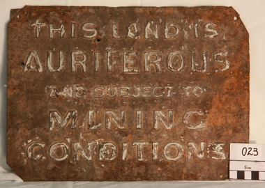
Gold Mining Sign
... Auriferous Mining...Inscription: "THIS LAND IS AURIFEROUS AND SUBJECT TO MINING CONDITIONS"...Such signs continued to be in use during the period between World War 1 and 2,including the period of the Great Depression. Auriferous Mining Inscription: "THIS LAND IS AURIFEROUS AND SUBJECT TO MINING CONDITIONS" Tin rectangular mining sign embossed with a warning Gold Mining Sign ...This sign was required to be displayed in the vicinity of gold mining sites. Myrtleford district was known to have had 100 sites within a ten mile radius of the town; the sign was recovered by Charlie McFadyen, a local prospector and fossicker, of some 60 yearsThe sign relates to local gold mining activity, a key source of wealth and employment from 1854 to the late 19th century. Such signs continued to be in use during the period between World War 1 and 2,including the period of the Great Depression.Tin rectangular mining sign embossed with a warningInscription: "THIS LAND IS AURIFEROUS AND SUBJECT TO MINING CONDITIONS"auriferous mining -
 Stawell Historical Society Inc
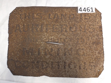
Memorabilia - Realia, 1850-1920's
... Rusted Tin Sign – "THIS LAND IS AURIFEROUS AND SUBJECT TO MINING CONDITIONS" This sign was required to be displayed in the vicinity of gold mining sites. ...Stawell Historical Society Inc 46 Longfield St Stawell grampians Stawell Rusted Tin Sign – "THIS LAND IS AURIFEROUS AND SUBJECT TO MINING CONDITIONS" This sign was required to be displayed in the vicinity of gold mining sites. ...Rusted Tin Sign – "THIS LAND IS AURIFEROUS AND SUBJECT TO MINING CONDITIONS" This sign was required to be displayed in the vicinity of gold mining sites. From 1850'c to between the two world wars. Found near Rhymney Hill Great Westernc1966stawell -
 Bendigo Historical Society Inc.
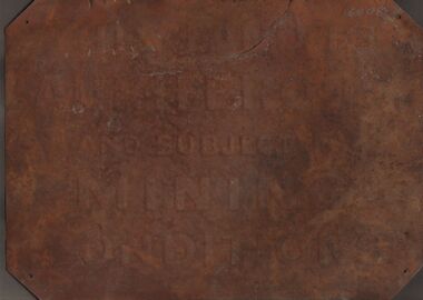
Sign - GOLDFIELDS SIGN
... The embossing reads: 'This Land is Auriferous and Subject to Mining Conditions.' The sign is very rusted and there is no trace of the original paintwork. ...History House 11 Mackenzie Street Bendigo goldfields GOLD MINING Miners' Safety Cage signage Gold mining Land use Signs Metal sign with embossed lettering, the corners have been folded over with mounting holes put through the thicker sections. The embossing reads: 'This Land is Auriferous ...Metal sign with embossed lettering, the corners have been folded over with mounting holes put through the thicker sections. The embossing reads: 'This Land is Auriferous and Subject to Mining Conditions.' The sign is very rusted and there is no trace of the original paintwork. A handwritten note with the sign reads: 'This sign was found covered by grass and eucalyptus leaves etc., at the side of the road leading past the Eucy. Factory in the vicinity of the Whipstick forest. Found in 1977 by Jean and Ross Miller, Wireless Street, Kangaroo Flat. At the time of scanning the lead article. The second item, a ladle, is being held in another location.gold mining, miners' safety cage, signage, gold mining, land use, signs -
 Federation University Historical Collection
Booklet, Report of the Board Appointed to Advise the Government as to the Best Mode of Developing the Auriferous and Mineral Resources of the Colony, 1879-80, 1880
... ballarat mining district...auriferous...Barker Library (top floor) Mount Helen goldfields mineral resources mining mining districts ballarat mining district auriferous resources william collard smith rivett henry bland henry rosales robert m. sergeant a.w. howitt deep leads carisbrook sebastopol sebastopol plateau r.m. harvey james m. main john wall g. hale t.h. thompson james leckie e.h. uren james cotter p. matthews w.k. peden john sharp g.c. robinson dead horse lead william benson j. keith smythesdale charles thorne haddon linton little bendigo scarsdale blackwood daylesford owen jones james mcmillan h.h. sainsbury thomas bury White Foolscap printed Government document relating Victoria's mineral resources. ...White Foolscap printed Government document relating Victoria's mineral resources.mineral resources, mining, mining districts, ballarat mining district, auriferous resources, william collard smith, rivett henry bland, henry rosales, robert m. sergeant, a.w. howitt, deep leads, carisbrook, sebastopol, sebastopol plateau, r.m. harvey, james m. main, john wall, g. hale, t.h. thompson, james leckie, e.h. uren, james cotter, p. matthews, w.k. peden, john sharp, g.c. robinson, dead horse lead, william benson, j. keith, smythesdale, charles thorne, haddon, linton, little bendigo, scarsdale, blackwood, daylesford, owen jones, james mcmillan, h.h. sainsbury, thomas bury -
Federation University Historical Collection
Letter, Inwards Correspondence to the Ballarat School of Mines, 1898, 1898
... Mining Company A. Vaudeau J.W. Banfield Letterhead* William Howard Smith and Sons Port Pirrie blakeville royal mint assay A number of handwritten letters bound together with a brass split pin on the top right corner. * Letter from Thomas Harwood from Port Darwin concerning bags of auriferous ...A number of handwritten letters bound together with a brass split pin on the top right corner. * Letter from Thomas Harwood from Port Darwin concerning bags of auriferous sand for treatment. * Letterhead from Ivor Davies, Cambrian Battery, Mosquito Flat * Request for results and certificates from D.W. Kennedy * J.H. Salter requesting a Ballarat School of Mines prospectus * Ballarat School of Mines Indentures student Thonmas Andrews * Letter introducing prospective student Walter Pomeroy * Ballarat School of Mines visit to New Normanby Mine * Letter from Sara McLean of Daylesfors asking about Botany, Geology and Drawing classes and railway forms. thomas harwood, darwin, mining, letterhead, ivor davis, frogmore sorell tasmania, d.w. kennedy, james horsfall, walter andrews, thomas p. lewis, j.h. salter, lettercard, queenstown tasmania, arch douglas, thomas andrews, gundagai, joseph bryant, c.m. bryant, percy glenton, clunes, land surveying, chalk and cahir, steam gauge testing, brisbane newspaper company, h. herman, t. price, geelong college letterhead, walter pomeroy, industrial schools act, n.r salmon, james and mccrindle, homes mccrindle, broken hill, j.e. blake, norval, john pearce, new nprmanby mine, maryborough school of mines, duncan mcdougall, old scotch collegians club, w.a. gosman, broken hill pty co. ltd, w. robertson, howard smith and sons, sara mclean, daylesford, william h. nicholas, surprise gold mining company, a. vaudeau, j.w. banfield, letterhead*, william howard smith and sons, port pirrie, blakeville, royal mint, assay -
Federation University Historical Collection
Booklet, Ballarat School of Mines, Prospectus, 1905-1906, 1905
... It also includes an advertisement for the practical treatment of Auriferous Ores in the Ballarat School of Mines Mining Laboratory. ...It also includes an advertisement for the practical treatment of Auriferous Ores in the Ballarat School of Mines Mining Laboratory. Ballarat School of Mines, Prospectus, 1905-1906 Booklet Booklet ...The Ballarat Technical Art School was part of the Ballarat School of MinesTwo Ballarat School of Mines Prospectuses of 16 pages. Both are the same but have different colour covers Contents includes teaching staff, school hours and subjects. It also includes an advertisement for the practical treatment of Auriferous Ores in the Ballarat School of Mines Mining Laboratory. ballarat school of mines, ballarat technical art school, design, modelling, figure drawing, fashion plate drawing, black and white illustration, wood carving, lettering, art metal work, retouching, architecture, architectural diploma, draughtsmen's courses, art teachers' courses, outdoor sketching classes, photography, building construction, architectural drawing, ticketwriting, signwriting and decorating, dressmaking, needlework, art teachers' certificate., ballarat school of mines model mine -
Federation University Historical Collection
Book, George Brown, Prospectors' Guide (Victoria), 1936, 1936
... Barker Library (top floor) Mount Helen goldfields prospecting gold geology quartz reefs indicators ballarat indicators miners' rights mining leases forest regulations equipment gold cradle puddling machine sluice box whim whip california pump cradle mining tools mining laws Brown soft covered book with pullout map showing auriferous areas of Victoria. ...Brown soft covered book with pullout map showing auriferous areas of Victoria. prospecting, gold, geology, quartz reefs, indicators, ballarat indicators, miners' rights, mining leases, forest regulations, equipment, gold cradle, puddling machine, sluice box, whim, whip, california pump, cradle, mining, tools, mining laws -
Federation University Historical Collection
Image, Robert Malachy Serjeant
... mining board. In 1977 Robert, Joseph Flude and Henry Caselli donated the patent rights of a novel Pyrites furnace to the school. The R.M. Serjeant Scholarship at the Ballarat School of Mines resulted after a reward was offered for the first to produce the best method of treating auriferous ores – other than the smelting method. ...mining board. In 1977 Robert, Joseph Flude and Henry Caselli donated the patent rights of a novel Pyrites furnace to the school. The R.M. Serjeant Scholarship at the Ballarat School of Mines resulted after a reward was offered for the first to produce the best method of treating auriferous ores – other than the smelting method. ...ROBERT MALACHY SERJEANT (1828-1902) Robert Malachy Serjeant was born on 21 December 1828 at Callington, Cornwall. He was the son of Philip Davey Serjeant, a surgeon in the Royal Marines, and Eliza Malachy. Philip Serjeant died in 1834. His mother, Eliza, remarried John Burgh in 1836. He died in 1837. In September 1848 Eliza, Robert and his two sisters, Caroline and Susan, departed Plymouth on the William Moneya for Port Adelaide and arrived in January 1849. Once gold was discovered in Victoria, Serjeant made his way to Forest Creek (near Castlemaine) and he and his mate Mr Victor, were the first party to sink through the basalt in search of a deep lead. In 1854 he moved to Ballarat to work as a miner and enjoyed some success. In 1855 he was with a group that discovered a 500 ounce nugget. With his share of the sale he set himself up with the latest mining equipment, as well as beginning a lifelong interest in the share market. He became the Manager of the Chryseis, Isis and Garibaldi claims and then the Manager of the Band and Albion Consol Company. He held the position for thirty years and only resigned when the company amalgamated with the Sir Henry Loch Mine. Robert Malachy Serjeant became interested in Politics. The first election for Parliament Representatives for Ballarat was in 1855. Robert stood for election for the first time in 1859, representing Ballarat West. He was also elected to represent Ballarat West in 1874 and 1880. Robert Serjeant’s community involvement extended to Education. Years of discussion eventually saw the development of the Ballarat School of Mines, the first school of mines in Australia. The inaugural School Council was formed in 1870 with Sir Redmond Barry, the Chief Justice, as President and Robert Malachy Serjeant as a member of the council. He held a position on the council until illness forced him to retire in 1889. He was elected a Life Governor in 1889. He was also a Life Governor of the Ballarat Hospital. Robert Serjeant showed Prince Albert and Prince George (later King George V) around the Band and Albion Mine. At the age of 42, Robert enrolled as a student at the School of Mines in 1871. He obtained a Certificate of Competency in Assaying (including Metallurgy) in 1875. The first certificate in “Geology as Applied to Mining” was awarded to Robert Serjeant in 1876. Robert Serjeant was an active and generous supporter of the School of Mines. As well as being a financial contributor, he lectured and examined in the Principles and Practice of Mining. He was regarded as an authority on alluvial and quartz mining and was a member of the Ballarat Local Court and mining board. In 1977 Robert, Joseph Flude and Henry Caselli donated the patent rights of a novel Pyrites furnace to the school. The R.M. Serjeant Scholarship at the Ballarat School of Mines resulted after a reward was offered for the first to produce the best method of treating auriferous ores – other than the smelting method. The offer was open for two years but not awarded. The money for this was donated by Robert Serjeant to the amount of 256 Pounds. It was then used to fund the School of Mines Scholarship in Engineering (1889). It was first awarded in 1922. Robert Malachy Serjeant died on 25 October 1902 and was buried at the Ballaarat Old Cemetery. (Sometimes Malachy is incorrectly written as Malachi)Two photographic portraits of mine manager Robert Malachy Serjeant. Both portraits were purchased by the donor from the State Library of Victoria. robert malachy serjeant, r.m. sergeant, robert malachi serjeant, band of hope and albion consols -
Federation University Historical Collection
Photograph - Image, Yarrowee Hall, Redan, c1883
... mining board. In 1977 Robert, Joseph Flude and Henry Caselli donated the patent rights of a novel Pyrites furnace to the school.
The R.M. Serjeant Scholarship at the Ballarat School of Mines resulted after a reward was offered for the first to produce the best method of treating auriferous ores – other than the smelting method. ...mining board. In 1977 Robert, Joseph Flude and Henry Caselli donated the patent rights of a novel Pyrites furnace to the school.
The R.M. Serjeant Scholarship at the Ballarat School of Mines resulted after a reward was offered for the first to produce the best method of treating auriferous ores – other than the smelting method. ...ROBERT MALACHY SERJEANT (1828-1902) Robert Malachy Serjeant was born on 21 December 1828 at Callington, Cornwall. He was the son of Philip Davey Serjeant, a surgeon in the Royal Marines, and Eliza Malachy. Philip Serjeant died in 1834. His mother, Eliza, remarried John Burgh in 1836. He died in 1837. In September 1848 Eliza, Robert and his two sisters, Caroline and Susan, departed Plymouth on the William Moneya for Port Adelaide and arrived in January 1849. Once gold was discovered in Victoria, Serjeant made his way to Forest Creek (near Castlemaine) and he and his mate Mr Victor, were the first party to sink through the basalt in search of a deep lead. In 1854 he moved to Ballarat to work as a miner and enjoyed some success. In 1855 he was with a group that discovered a 500 ounce nugget. With his share of the sale he set himself up with the latest mining equipment, as well as beginning a lifelong interest in the share market. He became the Manager of the Chryseis, Isis and Garibaldi claims and then the Manager of the Band and Albion Consol Company. He held the position for thirty years and only resigned when the company amalgamated with the Sir Henry Loch Mine. Robert Malachy Serjeant became interested in Politics. The first election for Parliament Representatives for Ballarat was in 1855. Robert stood for election for the first time in 1859, representing Ballarat West. He was also elected to represent Ballarat West in 1874 and 1880. Robert Serjeant’s community involvement extended to Education. Years of discussion eventually saw the development of the Ballarat School of Mines, the first school of mines in Australia. The inaugural School Council was formed in 1870 with Sir Redmond Barry, the Chief Justice, as President and Robert Malachy Serjeant as a member of the council. He held a position on the council until illness forced him to retire in 1889. He was elected a Life Governor in 1889. He was also a Life Governor of the Ballarat Hospital. Robert Serjeant showed Prince Albert and Prince George (later King George V) around the Band and Albion Mine. At the age of 42, Robert enrolled as a student at the School of Mines in 1871. He obtained a Certificate of Competency in Assaying (including Metallurgy) in 1875. The first certificate in “Geology as Applied to Mining” was awarded to Robert Serjeant in 1876. Robert Serjeant was an active and generous supporter of the School of Mines. As well as being a financial contributor, he lectured and examined in the Principles and Practice of Mining. He was regarded as an authority on alluvial and quartz mining and was a member of the Ballarat Local Court and mining board. In 1977 Robert, Joseph Flude and Henry Caselli donated the patent rights of a novel Pyrites furnace to the school. The R.M. Serjeant Scholarship at the Ballarat School of Mines resulted after a reward was offered for the first to produce the best method of treating auriferous ores – other than the smelting method. The offer was open for two years but not awarded. The money for this was donated by Robert Serjeant to the amount of 256 Pounds. It was then used to fund the School of Mines Scholarship in Engineering (1889). It was first awarded in 1922. Robert Malachy Serjeant died on 25 October 1902 and was buried at the Ballaarat Old Cemetery. (Sometimes Malachy is incorrectly written as Malachi)An copy of a photo of Yarrowee Hall, the home of of mine manager Robert Malachy Serjeant. robert malachy serjeant, r.m. sergeant, robert malachi serjeant, band of hope and albion consols, yarrowee hall, redan -
 Bendigo Historical Society Inc.
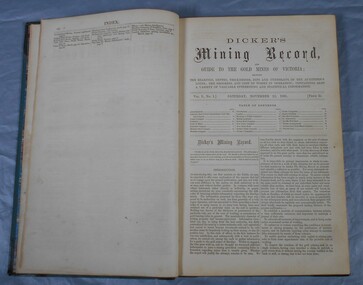
Book - DICKER'S MINING RECORD & GUIDE TO THE GOLD MINES OF VICTORIA, 1863
... Dicker's Mining Record and Guide to the Gold Mines of Victoria; showing the bearings, depths, thicknesses and underlies pf the Auriferous Lodes. ...Thomas Dicker Dicker's Mining Record and Guide to the Gold Mines of Victoria; showing the bearings, depths, thicknesses and underlies pf the Auriferous Lodes. ...Dicker's Mining Record and Guide to the Gold Mines of Victoria; showing the bearings, depths, thicknesses and underlies pf the Auriferous Lodes. The progress and cost of works in operation; containing also a variety of valuable interesting and statistical information. Vol. 11 - 1862 - 3. Published by the proprietor, Thomas Dicker with 276 pages. Green hardcover bound in leather with gold lettering and paper.Thomas Dickergold mining, mining equipment, mining records, mining, gold mines, mining statistics, mining companies. -
 Bendigo Historical Society Inc.
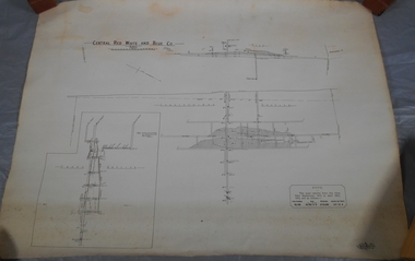
Plan - Central Red, White and Blue Mine
... Author: H E Whitelaw Share Abstract Early in 1910, some considerable time after it had become generally known that a rich reef at a depth of 405 ft was being worked southward from the privately owned Lansell's Little 180 shaft and immediately following the plotting of the Geological Survey pitch diagram of the Sheepshead line of reefs, some wide awake local mining men seized the opportunity to secure the holding known as Eadie's which, overlapping Lansell's lease and containing a stretch of the Sheepshead reef channel between the Little 180 north and south shafts, had been declared void some five years previously. That the Lansell Estate did not acquire this property on its becoming available is puzzling in the light of the fact that in Eadie's day the late Mr G W Lansell, on discovering auriferous spurs in the south shaft (now the Central Blue) had offered 2,000 pounds for, and a percentage of gold won from the lease. ...Author: H E Whitelaw Share Abstract Early in 1910, some considerable time after it had become generally known that a rich reef at a depth of 405 ft was being worked southward from the privately owned Lansell's Little 180 shaft and immediately following the plotting of the Geological Survey pitch diagram of the Sheepshead line of reefs, some wide awake local mining men seized the opportunity to secure the holding known as Eadie's which, overlapping Lansell's lease and containing a stretch of the Sheepshead reef channel between the Little 180 north and south shafts, had been declared void some five years previously. That the Lansell Estate did not acquire this property on its becoming available is puzzling in the light of the fact that in Eadie's day the late Mr G W Lansell, on discovering auriferous spurs in the south shaft (now the Central Blue) had offered 2,000 pounds for, and a percentage of gold won from the lease. https://search.informit.org/doi/10.3316/aesis.200105326 Bendigo gold Map Mine Central Red White & Blue Margaret Roberts Collection Sheepshead reef Draftsman's drawing of Central Red, White and Blue Mine Map. ...The Central Red White and Blue Gold Mine was Bendigo's leading gold mine from 1910 - 1913. During the mine's operation, the main shaft was sunk 670 metres, and retrieved over 2500KG of gold. The Central Red White and Blue Gold Mine was located on the corner of Chum St and Honeysuckle St in Golden Square. Extract from Whitelaw Report: Central Red White and Blue Mine, Bendigo. Author: H E Whitelaw Share Abstract Early in 1910, some considerable time after it had become generally known that a rich reef at a depth of 405 ft was being worked southward from the privately owned Lansell's Little 180 shaft and immediately following the plotting of the Geological Survey pitch diagram of the Sheepshead line of reefs, some wide awake local mining men seized the opportunity to secure the holding known as Eadie's which, overlapping Lansell's lease and containing a stretch of the Sheepshead reef channel between the Little 180 north and south shafts, had been declared void some five years previously. That the Lansell Estate did not acquire this property on its becoming available is puzzling in the light of the fact that in Eadie's day the late Mr G W Lansell, on discovering auriferous spurs in the south shaft (now the Central Blue) had offered 2,000 pounds for, and a percentage of gold won from the lease. https://search.informit.org/doi/10.3316/aesis.200105326 Draftsman's drawing of Central Red, White and Blue Mine Map. Printed by Troedel & Cooper Pty Ltd. Mr. H. Cundy, Surveyor Forms part of the Margaret Roberts Collection of mining records.bendigo, gold, map, mine, central red white & blue, margaret roberts collection, sheepshead reef -
 Bendigo Historical Society Inc.
Document - UNDERGROUND SURVEY OF BENDIGO MINES
... History House 11 Mackenzie Street Bendigo goldfields BENDIGO Mining garden gully line of reef mines Jems Stirling, geologist and W.H Cundy Underground Surveyor, Department of Mines Two page document, 'Underground survey of Bendigo, report on Constellation Company's Mine on northern extension of the Garden Gully line of reef. Report on the New Chum Railway Reserve Company and the Shenandoah Company, the New Chum Railway Co being immediately south and the Shenandoah Co immediately north of the railway line. Two maps Constellation Co. Mine shaft and New Chum Railway and Shenandoah auriferous ...Two page document, 'Underground survey of Bendigo, report on Constellation Company's Mine on northern extension of the Garden Gully line of reef. Report on the New Chum Railway Reserve Company and the Shenandoah Company, the New Chum Railway Co being immediately south and the Shenandoah Co immediately north of the railway line. Two maps Constellation Co. Mine shaft and New Chum Railway and Shenandoah auriferous reef below 2700 feet.Jems Stirling, geologist and W.H Cundy Underground Surveyor, Department of Minesbendigo, mining, garden gully line of reef mines -
 Bendigo Historical Society Inc.
Document - GARDEN GULLY LINE OF REEF, LEASE BLOCKS 5360 AND 5361
... The area described is about 'one mile and a quarter southeast from the centre of the city of Bendigo, immediately south of the Great Southern Gold Mining Company's workings and is intersected by two auriferous gullies ... ...The area described is about 'one mile and a quarter southeast from the centre of the city of Bendigo, immediately south of the Great Southern Gold Mining Company's workings and is intersected by two auriferous gullies ... ...Two page document titled ' Report on lease blocks Nos. 5360 and 5361 Garden Gully line of reef, Bendigo. Produced by the Department of Mines 1899. The area described is about 'one mile and a quarter southeast from the centre of the city of Bendigo, immediately south of the Great Southern Gold Mining Company's workings and is intersected by two auriferous gullies ... Salomon's Gully and Derwenter's Gully'. The alluvial deposits, the Garden Gully line, the Great Souther Co.and old workings are discussed in the paper. A map of the Garden Gully line of reef is attached to the report, showing claimholders and mine names along that section of the reef. Mines named on the map: Great Southern Garden Gully United Ulster Londonderry Burrows Horwoods Sea Amalgamated Garden Gully United Victory and Pandora Unity Carlisle and Garden Gully and Passbye United Cornish United Koch's PioneerJames Stirling, Government Geologistbendigo, mining, garden gully line of reef mines -
 Bendigo Historical Society Inc.
Journal - Dicker's Mining Journal 1862
... Dicker's Mining Record and guide to the gold mines of Victoria, showing the bearings, depths, thickness, dips and underlies of the auriferous lodes; the progress and cost of works in operation; containing also a variety of valuable interesting and statistical information. ...Dicker's Mining Record and guide to the gold mines of Victoria, showing the bearings, depths, thickness, dips and underlies of the auriferous lodes; the progress and cost of works in operation; containing also a variety of valuable interesting and statistical information. ...Thomas Dicker, Rowan Street, Bendigo, published a monthly mining journal that included geological information, mine details and mining practises for particular mining districts. In 1868/9, Dicker moved to England to open the "Australian and London Mining Agency" with the goals of promoting investment in Victorian mines, entering Victorian mining shares on the London Stock market, and exploring the latest in mining technology that might be suitable for mining in Victoria.Dicker's Mining Record and guide to the gold mines of Victoria, showing the bearings, depths, thickness, dips and underlies of the auriferous lodes; the progress and cost of works in operation; containing also a variety of valuable interesting and statistical information. Published by the proprietor, Thomas Dicker, Rowan Street Sandhurst. A green with black spine hardcover book. Paper glued on the front with the title Dicker's Mining Journal 1862. On the spine in gold lettering Dicker's Mining Record Vol.1 1861-2. The book contains 12 issues of the Dicker's Mining Record, the first from Saturday, November 23, 1861: the last from October 24, 1862. Also, there are two pieces of paper inside front cover with writing in pencil; the first says: shaft originally No.3 shaft of the speedwell coy. in 1902 the North Normanby Coy. was formed and took over the shaft. A new winding engine was installed in 1909. 10 head battery 1905, extra 20 head in 1909. The second, also in pencil, reads: Dept. of Mines Geological survey No.4 Ballarat East goldfields - 1907 - Mr. Marbrey (?) 39 Shamrock St. Bendigo.Sticker on inside front page: Ballarat Historical Museum presented by Mr. W.H. Lewis Young Street. On second page in pencil: Mr. John N Bailey mining manager of John Woods mines Stawell, Sons of Freedom Beaufort (illegible). To Mr. John Bailey as a mark of esteem grom J. Logan.dicker's mining journal, 1862, mining -
 Bendigo Historical Society Inc.
Slide - DIGGERS & MINING. DIGGERS AND MINERS, c1953
... Mining. Diggers and miners. Many diggers not only moved from field to field, but alternated between gold digging and other occupations. Slide; THE STATE OF VICTORIA - - - Gold digging and other sorts of labour have arrived at a sort of equilibrium; and streams of people are now flowing from the one occupation to the others, and visa versa. A few weeks ill luck at Bendigo disgust a man with his auriferous...Mining. Diggers and miners. Many diggers not only moved from field to field, but alternated between gold digging and other occupations. Slide; THE STATE OF VICTORIA - - - Gold digging and other sorts of labour have arrived at a sort of equilibrium; and streams of people are now flowing from the one occupation to the others, and visa versa. A few weeks ill luck at Bendigo disgust a man with his auriferous ...Diggers & Mining. Diggers and miners. Many diggers not only moved from field to field, but alternated between gold digging and other occupations. Slide; THE STATE OF VICTORIA - - - Gold digging and other sorts of labour have arrived at a sort of equilibrium; and streams of people are now flowing from the one occupation to the others, and visa versa. A few weeks ill luck at Bendigo disgust a man with his auriferous well sinking and he goes into some sort of service. A dispute with his master chiming in with some current takes of mining success sends him back to the diggings again; and so the stream flows backwards and forwards keeping - - - the wages of all kinds of labour at an equilibrium - - - (M.M.H., August 19, 1853) Markings: 46 994:LIF I. Used as a teaching aid.hanimounteducation, tertiary, goldfields -
 Bendigo Historical Society Inc.
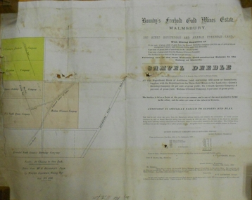
Document - MARKS COLLECTION: BOUNDY'S FREEHOLD GOLD MINES MALMSBURY
... auriferous and arable freehold land. Document contains map of mines, names include O'Connors Freehold Company, Egyptian Company, Queen's Birthday Company, No.1 South Queen Company, Madam O'Connor's company, Extended South Queen's Birthday Company. Scale 10 chains to one inch. Taken from Mr. H. Archdale's Plan by Walter Sleeman, Mining...auriferous and arable freehold land. Document contains map of mines, names include O'Connors Freehold Company, Egyptian Company, Queen's Birthday Company, No.1 South Queen Company, Madam O'Connor's company, Extended South Queen's Birthday Company. Scale 10 chains to one inch. Taken from Mr. H. Archdale's Plan by Walter Sleeman, Mining ...Plan/advertisement 1888 for the sale of the Boundy's Freehold Gold Mines Malmsbury, 260 acres of auriferous and arable freehold land. Document contains map of mines, names include O'Connors Freehold Company, Egyptian Company, Queen's Birthday Company, No.1 South Queen Company, Madam O'Connor's company, Extended South Queen's Birthday Company. Scale 10 chains to one inch. Taken from Mr. H. Archdale's Plan by Walter Sleeman, Mining Mgr., Oct 9th. 1888. On RH side of map Daylesford Road to Malmsbury marked. The land is only about two miles from the Malmsbury railway station. On back of document letter from Henry Nutman, Mining Manager, Queens Birthday Company; Report on Plan Walter Skleeman, M.M.; letter to S. Deeble, 35 Queen St., Melbourne with report on mine from George Jenkyn and Mining Manager's Report in Argus 24th.October 1888.mine, gold, boundy's freehold gold mine -
 Bendigo Historical Society Inc.
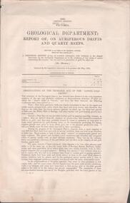
Document - MINING REPORTS - REPORT OF, ON AURIFEROUS DRIFTS AND QUARTZ REEFS
... MINING REPORTS - REPORT OF, ON AURIFEROUS DRIFTS AND QUARTZ REEFS...Mining Reports... Report of... on Auriferous...Document MINING REPORTS - REPORT OF, ON AURIFEROUS DRIFTS AND QUARTZ REEFS ...Printed document: Geological Department: Report of, on auriferous Drifts and Quartz Reefs, dated 8th May,1866. Paper describes the gravels and rocks of a Geological Survey. Survey is compared with the lower drifts of Bendigo, Epsom, Ballaarat, Castlemaine and other gold-fields. Four colour sketch-sections included. Document is part of the Albert Richardson Collection. gold, mining reports, mining reports, report of, on auriferous drifts and quartz reefs, mr bindon, alfred r c selwyn, john ferres -
 Federation University Historical Collection
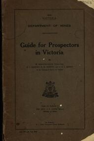
Book, Guide for Prospectors in Victoria, 1931, 1931
... auriferous areas and mineral localities. Also show Counties of Victoria and localities of minerals such as tin, antimony, copper, silver lead, Malybdenite, tungsten ores, manganese, platinum, osmiridium and iron. Chapter heading s include: working alluvial deposits, equipment, geology of Victoria, gold deposits, quartz reefs, indicators, economic minerals, assistance to prospectors, Miners' Right, mining bye-law, mining leases, forest regulations and glossary. ...Barker Library (top floor) Mount Helen goldfields The handbook was intended for those with little experience who wanted to prospect of fossick. mining baragwanath gold prospector geology quartz reefs alluvial deposits indicators victorian goldfields miners rights mining leases forest regulations sluicing sluice box puddling machine miner's cradle whim whip california pump gold nuggets saddle reef ballarat indicators state batteries Grey soft covered book of 90 pages. Includes fold out map of a portion of Victoria showing auriferous ...The handbook was intended for those with little experience who wanted to prospect of fossick.Grey soft covered book of 90 pages. Includes fold out map of a portion of Victoria showing auriferous areas and mineral localities. Also show Counties of Victoria and localities of minerals such as tin, antimony, copper, silver lead, Malybdenite, tungsten ores, manganese, platinum, osmiridium and iron. Chapter heading s include: working alluvial deposits, equipment, geology of Victoria, gold deposits, quartz reefs, indicators, economic minerals, assistance to prospectors, Miners' Right, mining bye-law, mining leases, forest regulations and glossary. Descriptions are given of a god dish, puddling tub, cradle, puddling machine, ground sluicing, boring, windlass, whim, hand dollying, sweeping, California pump, and wing dam.mining, baragwanath, gold, prospector, geology, quartz reefs, alluvial deposits, indicators, victorian goldfields, miners rights, mining leases, forest regulations, sluicing, sluice box, puddling machine, miner's cradle, whim, whip, california pump, gold nuggets, saddle reef, ballarat indicators, state batteries -
 Federation University Historical Collection
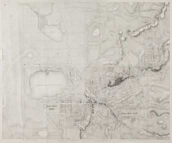
Map, Ballaarat Gold Field, 1861, 1861
... Mining Surveyors Davidson, Fitzpatrick and Cowan & the Plans in the Surveyor General's Office by J. Brahe, 21st October 1861. R. Brough Smyth, Secretary for Mines. The Honourable J.B. Humffray, M.L.A. Commr of Mines.” Original 1861 map of Ballarat showing streets and leads. Blue dots indicate gold leads, and red lines indicate auriferous ...A party of surveyors camped by Yuille's Swamp (later Lake Wendouree) and surveyed the countryside for a map to be produced by the Geological Survey of Victoria. In November 2004 the Central Highlands Regional Library presented a special edition of 200 copies of the 1861 map reproduced from a copy in their collection. Original 1861 map of Ballarat showing streets and leads. Blue dots indicate gold leads, and red lines indicate auriferous quartz reef and outcrops of quartz veins."Compiled & Drawn from the Survey of Mining Surveyors Davidson, Fitzpatrick and Cowan & the Plans in the Surveyor General's Office by J. Brahe, 21st October 1861. R. Brough Smyth, Secretary for Mines. The Honourable J.B. Humffray, M.L.A. Commr of Mines.”ballarat, map, ballarat east, lake wendouree, survey, mines, robert davidson, ballarat gold field 1861, yuille's swamp, wendouree swamp, little bendigo diggings, gold leads, old post office hill, specimen hill, bakery hill, black hill, dead horse creek, brown hill, pennyweight hill, clayton hill, soldiers hill, golden point, gum tree flat, white flat, poverty hill, chinese village, robert brough smyth, ballarat map 1861, ballaarat vineyard, dead horse gully, deadhorse creek, invermay, black hill flat, gaelic church, police reserve, magpie range, dalton's flat, caadian lead, rifle butts, powder magazine, bathing house, government camp, gold office, chinese, llanberrris, victoria theatre, charlie napier hotel, united states hotel, grape's hoel, clayton's hill, cattleyard hill, free trade hotel, esmond lead, bakery hill, black hill lead, juvenile reformatory, ballarat orphanage, lady barkly lead, triffet's slaughter yard, little bendigo, melbourne road, t. cowan, thomas cowan -
 Federation University Historical Collection
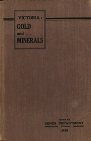
Book, Victoria: Gold and Minerals, 1935, 1935
... Barker Library (top floor) Mount Helen goldfields victoria gold minerals 1935 geological map hydrolic sluicing panning pneumatic drill puddling machine bendigo coal mine wonthaggi yallourn jamieson valley geological school melbourne university mount buffalo electric power station briquette factory mines department george brown secretary of mines e.j. hogan minister of mines mining Hard cover book. Fold out map showing auriferous areas and mineral localities in Victoria, 1935 Victoria: Gold and Minerals, 1935 Book Book ...Hard cover book. Fold out map showing auriferous areas and mineral localities in Victoria, 1935victoria, gold, minerals, 1935, geological map, hydrolic sluicing, panning, pneumatic drill, puddling machine, bendigo, coal mine, wonthaggi, yallourn, jamieson valley, geological school, melbourne university, mount buffalo, electric power station, briquette factory, mines department, george brown, secretary of mines, e.j. hogan, minister of mines, mining -
 Federation University Historical Collection
Book, Selection of Geological Publications, 09/1866
... auriferous...lead...silver ores...nuggetty reef...maldon...victoria...internal communication...roads for victoria...mining...Auriferous, Leads, & Silver Ores at Upper Hungary - G.H.F. Ulrich, 1868 2. Nuggetty Reef, Maldon, Victoria - G.H.F. Ulrich, 1866 3. Internal Communication - Lieut. Amsinck, 1856 4. Roads for Victoria - William Macredie, 1856 5. Mining...Auriferous, Leads, & Silver Ores at Upper Hungary - G.H.F. Ulrich, 1868 2. Nuggetty Reef, Maldon, Victoria - G.H.F. Ulrich, 1866 3. Internal Communication - Lieut. Amsinck, 1856 4. Roads for Victoria - William Macredie, 1856 5. Mining ...This book was owned and used by Professor Ferdinand M. Krause of the Ballarat School of Mines.Ferdinand Krause was a renowned teacher at the Ballarat School of Mines. He also produced many important Geological Maps. This book has seven reports that Krause had bound together for his own use. Half black leather bound book with hand marbled paper cover. Marbling on cover is grey, maroon and darker grey with gold bands on black leather spine. The book contains 7 papers on various subjects associated with ores. The book includes: 1. Auriferous, Leads, & Silver Ores at Upper Hungary - G.H.F. Ulrich, 1868 2. Nuggetty Reef, Maldon, Victoria - G.H.F. Ulrich, 1866 3. Internal Communication - Lieut. Amsinck, 1856 4. Roads for Victoria - William Macredie, 1856 5. Mining & Mineral Statistics of Victoria - Robert Brough Smyth, 1866 6. Physical Geography & Geology of Victoria - R.C. Selwyn, 1866 7. Mineralogy of Victoria - G.H.F. Ulrich, 1866 Leather component is black with gold bands on spine with "Silver Ores etc" written on spine. 'G" on square cream paper at top of spine; "2" on square cream paper on middle of spine; and "3" on square cream paper on bottom of spine. Inside front cover on red paper rectangle near spine "bound by W. PAUL 17 Lydiard St BALLARAT" "Ferdinand M Krause C E" handwritten in black ink on title page of first paper (right hand side)treatment, auriferous, lead, silver ores, nuggetty reef, maldon, victoria, internal communication, roads for victoria, mining, mineral statistics, geography, geology, mineralogy, ulrich, amsinck, selwyn, ferdinand krause, macredie -
Clunes Museum
Document - GEOLOGICAL REPORT, CIRCA 1897
... LIDGEY, FIELD GEOLOGIST, 1897 local history document report mining SEE OVER REPORT ON AURIFEROUS ZONE FROM ROKEWOOD TO CLUNES, AND THENCE TO MOUNT CAMERON Document GEOLOGICAL REPORT ...REPORT BY E. LIDGEY, FIELD GEOLOGIST, 1897REPORT ON AURIFEROUS ZONE FROM ROKEWOOD TO CLUNES, AND THENCE TO MOUNT CAMERONSEE OVERlocal history, document, report, mining -
 Ballarat Heritage Services
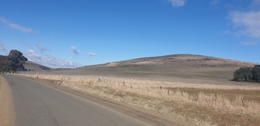
Photograph - Colour Photograph, Clare Gervasoni, Mount Greenock, 2025, 28/06/2025
... The lava flow and the scoria cone overlie the Greenock lead (a buried valley with auriferous gravels). A line of mine tailing and abandoned mining relics associated with the former Union Mine occur on the margins of the lava flow. ...The lava flow and the scoria cone overlie the Greenock lead (a buried valley with auriferous gravels). A line of mine tailing and abandoned mining relics associated with the former Union Mine occur on the margins of the lava flow. ...Mt Greenock is an extinct volcano with lava flows associated with a deep lead. It is a tall scoria cone with a broad shallow crater open to the northwest. In the crater are blocks and bombs of scoriaceous basalt. Long lava flows extend both north and south from the cone. It is considered a significant geological site, and part of the Major Mitchell Trail, with a 1936 ‘Centenary of Major Mitchell ‘monument on the summit. The flow to the north has been eroded by McCallum Creek which is a lateral stream. On the eastern base of the cone, the stream valley exposes a lava flow and underlying sedimentary rocks. The lava flow and the scoria cone overlie the Greenock lead (a buried valley with auriferous gravels). A line of mine tailing and abandoned mining relics associated with the former Union Mine occur on the margins of the lava flow. Mount Greenock is a 120 hectare ‘Geological Reserve’, is one of the few large scoria cones on public land and contains abundant outcrop and morphological evidence of its volcanic origin. Colour Photographs of Mt Greenock, near Talbot, Victoria. The photographs were taken in winter not long after the first post drought rains. Mt Greenock was climbed by Major Thomas Mitchell on 26 September 1936, and he gave it the current name. At that time the mount was part of Alexander McCallum's Dunach Forest Pastoral Run.mt greenock, mount greenock, mining, mullock heap, mt greenock geological reserve, union mine, volcanic grasslands, dunach -
 Ballarat Heritage Services
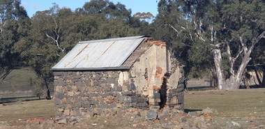
Photograph - Colour Photograph, Clare Gervasoni, Built Remains near Mount Greenock, 2025, 28/06/2025
... The lava flow and the scoria cone overlie the Greenock lead (a buried valley with auriferous gravels). A line of mine tailing and abandoned mining relics associated with the former Union Mine occur on the margins of the lava flow. ...The lava flow and the scoria cone overlie the Greenock lead (a buried valley with auriferous gravels). A line of mine tailing and abandoned mining relics associated with the former Union Mine occur on the margins of the lava flow. ...Mt Greenock is an extinct volcano with lava flows associated with a deep lead. It is a tall scoria cone with a broad shallow crater open to the northwest. In the crater are blocks and bombs of scoriaceous basalt. Long lava flows extend both north and south from the cone. It is considered a significant geological site, and part of the Major Mitchell Trail, with a 1936 ‘Centenary of Major Mitchell ‘monument on the summit. The flow to the north has been eroded by McCallum Creek which is a lateral stream. On the eastern base of the cone, the stream valley exposes a lava flow and underlying sedimentary rocks. The lava flow and the scoria cone overlie the Greenock lead (a buried valley with auriferous gravels). A line of mine tailing and abandoned mining relics associated with the former Union Mine occur on the margins of the lava flow. Mount Greenock is a 120 hectare ‘Geological Reserve’, is one of the few large scoria cones on public land and contains abundant outcrop and morphological evidence of its volcanic origin. Colour Photographs of bluestone and brick buildings at Mt Greenock, near Talbot, Victoria. The photographs were taken in winter not long after the first post drought rains. mt greenock, mount greenock, mining, mullock heap, mt greenock geological reserve, union mine, volcanic grasslands, dunach -
 Bendigo Historical Society Inc.
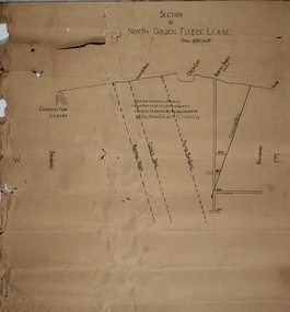
Plan - North Golden Fleece Lease, unknown
... North Golden Fleece Gold Mine gold mining Bendigo lease holding Albert Gold Mine Ramrod Reef Comet Reef Stafford Reef and Frying Pan Reef Map drawn on heavy paper, titled 'Section of North Golden Fleece lease'. Scale 80 ft to 1 inch. Written on plan in black print: 'This belt of country contains large bodies of auriferous ...Map drawn on heavy paper, titled 'Section of North Golden Fleece lease'. Scale 80 ft to 1 inch. Written on plan in black print: 'This belt of country contains large bodies of auriferous quartz and at present is being operated on by the New Golden Fleece Company'. Reef lines marked on plan: Ramrod Reef, Comet Reef, Stafford Reef and Frying Pan Reef. The water race, Albert shaft and open cut are marked at the surface level. This plan is part of the Margaret Roberts Collection. north golden fleece gold mine, gold mining, bendigo, lease holding, albert gold mine, ramrod reef, comet reef, stafford reef and frying pan reef -
 Bendigo Historical Society Inc.
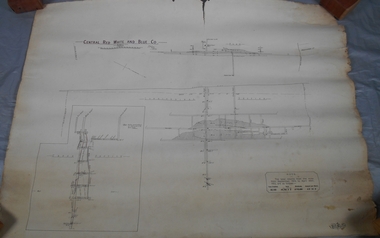
Map - Central Red White and Blue Co, 1913
... Author: H E Whitelaw Abstract Early in 1910, some considerable time after it had become generally known that a rich reef at a depth of 405 ft was being worked southward from the privately owned Lansell's Little 180 shaft and immediately following the plotting of the Geological Survey pitch diagram of the Sheepshead line of reefs, some wide awake local mining men seized the opportunity to secure the holding known as Eadie's which, overlapping Lansell's lease and containing a stretch of the Sheepshead reef channel between the Little 180 north and south shafts, had been declared void some five years previously. That the Lansell Estate did not acquire this property on its becoming available is puzzling in the light of the fact that in Eadie's day the late Mr G W Lansell, on discovering auriferous spurs in the south shaft (now the Central Blue) had offered 2,000 pounds for, and a percentage of gold won from the lease. ...Author: H E Whitelaw Abstract Early in 1910, some considerable time after it had become generally known that a rich reef at a depth of 405 ft was being worked southward from the privately owned Lansell's Little 180 shaft and immediately following the plotting of the Geological Survey pitch diagram of the Sheepshead line of reefs, some wide awake local mining men seized the opportunity to secure the holding known as Eadie's which, overlapping Lansell's lease and containing a stretch of the Sheepshead reef channel between the Little 180 north and south shafts, had been declared void some five years previously. That the Lansell Estate did not acquire this property on its becoming available is puzzling in the light of the fact that in Eadie's day the late Mr G W Lansell, on discovering auriferous spurs in the south shaft (now the Central Blue) had offered 2,000 pounds for, and a percentage of gold won from the lease. https://search.informit.org/doi/10.3316/aesis.200105326 Bendigo Margaret Roberts gold Central Red White and Blue Gold Mine Map Margaret Roberts Collection Hand drawn plan of Central Red, White and Blue Mine. ...The Central Red White and Blue Gold Mine was Bendigo's leading gold mine from 1910 - 1913. During the mine's operation, the main shaft was sunk 670 metres, and retrieved over 2500KG of gold. The Central Red White and Blue Gold Mine was located on the corner of Chum St and Honeysuckle St in Golden Square.. During the mine's operation, the main shaft was sunk 670 metres, and retrieved over 2500KG of gold. The registration of the Company in 1891 (Government Gazette 138, November 6th. 1891, page 4465) lists the value of the Company's property as three hundred and fifty pounds. The number of shares was thirty thousand at 2 shillings each. The Manager was Mr. William Weeks Barker. Ref: https://gazette.slv.vic.gov.au/view.cgi?year=1891&class=general&page_num=4465&state=v&classnum=g138&id= Extract from Whitelaw Report: Central Red White and Blue Mine, Bendigo. Author: H E Whitelaw Abstract Early in 1910, some considerable time after it had become generally known that a rich reef at a depth of 405 ft was being worked southward from the privately owned Lansell's Little 180 shaft and immediately following the plotting of the Geological Survey pitch diagram of the Sheepshead line of reefs, some wide awake local mining men seized the opportunity to secure the holding known as Eadie's which, overlapping Lansell's lease and containing a stretch of the Sheepshead reef channel between the Little 180 north and south shafts, had been declared void some five years previously. That the Lansell Estate did not acquire this property on its becoming available is puzzling in the light of the fact that in Eadie's day the late Mr G W Lansell, on discovering auriferous spurs in the south shaft (now the Central Blue) had offered 2,000 pounds for, and a percentage of gold won from the lease. https://search.informit.org/doi/10.3316/aesis.200105326 Hand drawn plan of Central Red, White and Blue Mine. Cross section and longitudinal plan drawn on plan. Printed name on top of plan: 'Central Red White and Blue Co' Plan printed by Troedel & Cooper Pty Ltd. Surveyor W. H. Cundy, Bendigo April 1913 Plan is part of the Margaret Roberts Collection of mining records.bendigo, margaret roberts, gold, central red white and blue gold mine, map, margaret roberts collection -
 Bendigo Historical Society Inc.
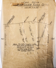
Plan - North Golden Fleece Mine
... On bottom of plan: ' This belt of country contains large bodies of auriferous quartz and is now being operated upon by the New Golden Fleece Co.' Plan forms part of the Margaret Roberts Collection of mining records. ...On bottom of plan: ' This belt of country contains large bodies of auriferous quartz and is now being operated upon by the New Golden Fleece Co.' Plan forms part of the Margaret Roberts Collection of mining records. ...North Golden Fleece Gold Mine was located approx. 1200m west of Spring Gully Reservoir, near Diamond Hill Road. Plan drawn on tan tissue paper, black text. Written across top of plan: 'Cross Section, North Golden Fleece Co. 160' to an inch'. Annotations on plan: Carshalton line, water race, open cut, Albert Shaft 10'6" x 4, road. East and West marked on plan. On bottom of plan: ' This belt of country contains large bodies of auriferous quartz and is now being operated upon by the New Golden Fleece Co.' Plan forms part of the Margaret Roberts Collection of mining records. margaret roberts, gold, gold mine, bendigo, north golden fleece gold mine, spring gully reservoir