Showing 241 items matching "avenue of the station"
-
 Federation University Historical Collection
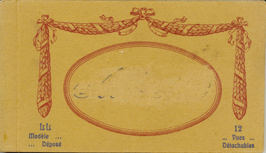
Postcard - Postcard Booklet, Levi Fils & Co, Vues Detachables
... ...avenue of the station...p=/discussion/1306/levy-fils-cie-paris-specifically-lucien-levy-ll Abbeyville was a town in the Somme, so that this is a possible reason that the name has been erased on the postcard. http://www.france-voyage.com/travel-photos/abbeville-11435.htm abbeyville levy fils postcard vues panorama place de l'amiral-courbet monument rue alfred-cendre alfred-cendre street statue saint vulfran church saint gilles church museum prarona statue avenue de la gars avenue of the station chevalier de la barre river somme somme talence bridge correspondence carte postale censor censored Print "Modele ... ...Levy Sons & Co. 1895-1919 Paris, France and London, England In 1864 the Parisian photographic studio of Ferrier pere*, fils & Soulier was bought out and became M. Leon & J. Levy. This partnership lasted until 1872 when Leon left and it was renamed J. Levy & Co., which became an important producer of stereo-views and lantern slides. By 1895 his sons had joined the company and it was renamed once again to Levy Sons & Co. (or Levy et ses Fils). His son Lucien became a well known photographer who began publishing international view-cards from his own work depicting scenes mostly from within the French empire, though quite a number are from England and there are some from Australia and Russia as well. There are few French towns that are not captured by his cards. His name does not appear on the cards but - L.L. follows the title as a photo credit. Many of their cards are not attributed. These cards were printed as colotypes in black & white, sepia, and over speckled color lithography. In 1920 the studio united with Neurdein Freres to become Levy & Neurdein reunis. Their negatives are now owned by the Roger-Viollet Photographic Agency. *Claude Marie Ferrier (1811-1889) was also an important early photographer. He was the 'Pere' in Ferrier Pere, Fils & Soulier - best remembered for their stunning series of glass views. Sorting this collection is a challenge. The postcard rears display a variety of forms - a) garland emblem with LL inside, b) with an addition emblem within (FPS?). Or c) - no emblem which may mean production by another company - however LL. remains on the front as a credit to the photographer. http://www.metropostcard.com/picslogos/pcl-levylucien.jpg.jpg http://www.unpi.com/clem/unpostcards/LON1919PC2Naback.jpg Example Colour Card circa 1920 No. 78 Paris - L'Escalier de l'Opera - LL. http://www.postcardcollector.org/forum/index.php?p=/discussion/1306/levy-fils-cie-paris-specifically-lucien-levy-llAbbeyville was a town in the Somme, so that this is a possible reason that the name has been erased on the postcard. http://www.france-voyage.com/travel-photos/abbeville-11435.htmSmall brown covered book of 12 postcards with views of Abbeyville in the Somme. Issue between each each individual postcard. The cover has an oval on front and the name "Abbeyville" in its centre has been erased. The name of the town has also been erased (censored) throughout the booklet. There is a garland in maroon around the maroon oval on the front cover. Print in dark grey on bottom left and right hand side corners.Print "Modele ... Depose" in dark grey on bottom left and "12 Vues Detachables" on right hand side corners. Names of places printed inside but the name of the town has been erased throughout. "Carte Postale" with logo underneath at centre and "Correspondence" LHS and "Adresse" RHS on top of verso of each postcard in booklet. "Levy Fils & Co, Paris sideways along centre line of postcard on verso.abbeyville, levy fils, postcard, vues, panorama, place de l'amiral-courbet, monument, rue alfred-cendre, alfred-cendre street, statue, saint vulfran church, saint gilles church, museum, prarona statue, avenue de la gars, avenue of the station, chevalier de la barre, river somme, somme, talence bridge, correspondence, carte postale, censor, censored -
 Whitehorse Historical Society Inc.
Map, Burwood Road, Box Hill City, 15/02/1952 12:00:00 AM
... Between Milford Avenue and Station Street. Marked as Survey Plan No 5441....Plan of subdivision of ten blocks in Burwood Road, Burwood between Milford Avenue and Station Street. Marked as Survey Plan No 5441....Whitehorse Historical Society Inc. 2-10 Deep Creek Road Mitcham melbourne Between Milford Avenue and Station Street. Marked as Survey Plan No 5441. ...Plan of subdivision of ten blocks in Burwood Road, Burwood.Plan of subdivision of ten blocks in Burwood Road, Burwood between Milford Avenue and Station Street. Marked as Survey Plan No 5441.Plan of subdivision of ten blocks in Burwood Road, Burwood. land subdivision, burwood road, burwood, milford avenue, burwood, central court, burwood -
 Greensborough Historical Society
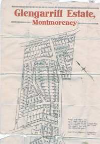
Map, Glengarriff Estate Montmorency, 1938c
... avenue montmorency...montmorency station...Bordered by Sherbourne Avenue, Calrossie Avenue, Montmorency Station and Price Avenue...Bordered by Sherbourne Avenue, Calrossie Avenue, Montmorency Station and Price Avenue glengarriff estate montmorency sherbourne avenue montmorency calrossie avenue montmorency price avenue montmorency montmorency station Colour photocopy of subdivision map, on two A3 sheets Glengarriff Estate Montmorency Map T. ...Estate Agent's plan of Glengarriff Estate, Montmorency, covering LPs 11334 and 11451. Bordered by Sherbourne Avenue, Calrossie Avenue, Montmorency Station and Price AvenueColour photocopy of subdivision map, on two A3 sheets glengarriff estate montmorency, sherbourne avenue montmorency, calrossie avenue montmorency, price avenue montmorency, montmorency station -
 Chelsea & District Historical Society Inc
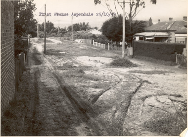
Photograph - First Avenue, Aspendale, 1949
... This photo is one of a collection of photos taken during Alan Niemann's - Drainage-Road Making Scheme. First Avenue runs between Station Street and Sixth Avenue....Chelsea & District Historical Society Inc The Chelsea Activity Hub 3-5 Showers Ave Chelsea 3196 melbourne This photo is one of a collection of photos taken during Alan Niemann's - Drainage-Road Making Scheme. First Avenue runs between Station Street and Sixth Avenue. unmade street Aspendale First Avenue Alan Niemann Drainage-Road Making Scheme Black and white photo looking east along First Avenue, Aspendale. ...This photo is one of a collection of photos taken during Alan Niemann's - Drainage-Road Making Scheme. First Avenue runs between Station Street and Sixth Avenue.Black and white photo looking east along First Avenue, Aspendale. The road us unmade and rusted with vegetation growing on the road, houses and electricity poles line both sides. unmade street, aspendale, first avenue, alan niemann, drainage-road making scheme -
 Chelsea & District Historical Society Inc
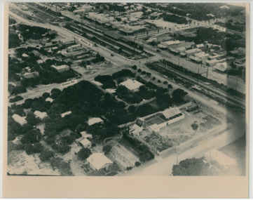
Photograph - Aerial Photo of Chelsea, c 1923
... Black and white aerial photo of Chelsea, bordered by Thames Promenade, Balantyne Avenue, Catherine Avenue and Chelsea Road, Station Street, The Strand, Bath Street....Station W. H. Hansom ("Manders") Aerial Artist, Personally Conducted Flights over Melbourne and Suburbs St James' Building Bourke Street, Melbourne Black and white aerial photo of Chelsea, bordered by Thames Promenade, Balantyne Avenue, Catherine Avenue and Chelsea Road, Station Street, The Strand, Bath Street. ...Points of interest in the photo are Fox Theatre, Chelsea Railway Station and the building site of Masons Theatre on the corner of Chelsea Road and Station Street. Mr William Herbert Hansom was a pioneer of aerial photography in Australia.Black and white aerial photo of Chelsea, bordered by Thames Promenade, Balantyne Avenue, Catherine Avenue and Chelsea Road, Station Street, The Strand, Bath Street.W. H. Hansom ("Manders") Aerial Artist, Personally Conducted Flights over Melbourne and Suburbs St James' Building Bourke Street, Melbournechelsea, aerial photo, station street, chelsea road, the strand, bath street, fox theatre, masons theatre, w. h. hansom, chelsea railway station -
 Greensborough Historical Society
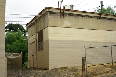
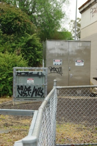
Photograph - Photograph - Digital Image, Marilyn Smith, Poulter Avenue power station - Greensborough Railway Station 2021, 2021_02
... Poulter Avenue power station - Greensborough Railway Station 2021...station...hurstbridge rail line upgrade...poulter avenue...Photographs of Poulter Avenue power station at Greensborough Railway Station in February 2021, before the planned rebuild of the station as part of the Hurstbridge rail line upgrade. ...Greensborough Historical Society 34A Glenauburn Road Lower Plenty Lower Plenty melbourne Photographs of Poulter Avenue power station at Greensborough Railway Station in February 2021, before the planned rebuild of the station as part of the Hurstbridge rail line upgrade. greensborough railway station hurstbridge rail line upgrade poulter avenue greensborough 4 Colour digital photographs Poulter Avenue power station - Greensborough Railway Station 2021 Photograph Photograph - Digital Image Marilyn Smith ...Photographs of Poulter Avenue power station at Greensborough Railway Station in February 2021, before the planned rebuild of the station as part of the Hurstbridge rail line upgrade. 4 Colour digital photographsgreensborough railway station, hurstbridge rail line upgrade, poulter avenue greensborough -
 Greensborough Historical Society
Photograph - Photograph - Digital Image, Marilyn Smith, Poulter Avenue power station, architectural features - Greensborough Railway Station 2021, 2021_02
... Poulter Avenue power station, architectural features - Greensborough Railway Station 2021...station...hurstbridge rail line upgrade...poulter avenue...Photographs of architectural features at Poulter Avenue power station at Greensborough Railway Station in February 2021, before the planned rebuild of the station as part of the Hurstbridge rail line upgrade. ...Greensborough Historical Society 34A Glenauburn Road Lower Plenty Lower Plenty melbourne Photographs of architectural features at Poulter Avenue power station at Greensborough Railway Station in February 2021, before the planned rebuild of the station as part of the Hurstbridge rail line upgrade. greensborough railway station hurstbridge rail line upgrade poulter avenue greensborough 5 Colour digital photographs Poulter Avenue power station, architectural features - Greensborough Railway Station 2021 Photograph Photograph - Digital Image Marilyn Smith ...Photographs of architectural features at Poulter Avenue power station at Greensborough Railway Station in February 2021, before the planned rebuild of the station as part of the Hurstbridge rail line upgrade. 5 Colour digital photographsgreensborough railway station, hurstbridge rail line upgrade, poulter avenue greensborough -
Ringwood and District Historical Society
Envelope, Packet: Greenwood Sub-division (plans, 1924 notes etc)
... "Greenwood" subdivision, Greenwood Avenue & Station Street 22 pages plus several subdivisional plans....Ringwood and District Historical Society 125A Warrandyte Road Ringwood North melbourne "Greenwood" subdivision, Greenwood Avenue & Station Street 22 pages plus several subdivisional plans. ..."Greenwood" subdivision, Greenwood Avenue & Station Street 22 pages plus several subdivisional plans. -
 Ringwood and District Historical Society
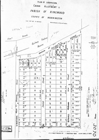
Document - Map, Plan of Subdivision, Part of Crown Portion 11, Parish of Ringwood, County of Mornington - circa 1890
... A4 photocopy showing numbers and perimeter measurements of allotments on Station Street (previously Railway Avenue), Wantirna Road (previously West Prussia Road), James Street and Kendall Street (previously William Street). ...Notations include incorrect order of street name amendment between Station Street and Railway Avenue in 1952. Railway Avenue was re-named Station Street. ...Ringwood and District Historical Society 125A Warrandyte Road Ringwood North melbourne Notations include incorrect order of street name amendment between Station Street and Railway Avenue in 1952. Railway Avenue was re-named Station Street. ...A4 photocopy showing numbers and perimeter measurements of allotments on Station Street (previously Railway Avenue), Wantirna Road (previously West Prussia Road), James Street and Kendall Street (previously William Street). Notations include incorrect order of street name amendment between Station Street and Railway Avenue in 1952. Railway Avenue was re-named Station Street. Date missing from street name amendment from West Prussia Road to Wantirna Road. -
 Greensborough Historical Society
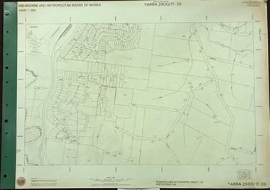
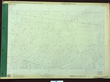
Map, Melbourne and Metropolitan Board of Works. Survey Division, MMBW, Yarra 2500 / 17.26. Hurstbridge, 1978_01
... Prominent streets include: Flat Rock Road and Heather Avenue. Includes Hurstbridge Railway Station....Prominent streets include: Flat Rock Road and Heather Avenue. Includes Hurstbridge Railway Station. mmbw melbourne and metropolitan board of works shire of diamond valley hurstbridge - maps MMBW Map in 1:2500 [scale] series. ...Melbourne and Metropolitan Board of Works. Yarra 2500 [base map] 17-26. Hurstbridge. Municipalities of Diamond Valley 257 and Eltham 238. Prominent streets include: Flat Rock Road and Heather Avenue. Includes Hurstbridge Railway Station.MMBW Map in 1:2500 [scale] series. Cream parchment with green tape reinforcing on edges and punched holes on left edge.mmbw, melbourne and metropolitan board of works, shire of diamond valley, hurstbridge - maps -
 Greensborough Historical Society
Map, Melbourne and Metropolitan Board of Works. Survey Division, MMBW, Yarra 2500 / 14.20. Montmorency, Sherbourne Road, 1977_06
... Prominent streets: Sherbourne Road, Karingal Drive and Calrossie Avenue. Features include Montmorency Station and Meruka Park....Prominent streets: Sherbourne Road, Karingal Drive and Calrossie Avenue. Features include Montmorency Station and Meruka Park. mmbw melbourne and metropolitan board of works shire of diamond valley montmorency - maps MMBW Map in 1:2500 [scale] series. ...Melbourne and Metropolitan Board of Works. Yarra 2500 [base map] 14.20. Montmorency, Sherbourne Road. Municipality of Diamond Valley 257 and Eltham 238. Prominent streets: Sherbourne Road, Karingal Drive and Calrossie Avenue. Features include Montmorency Station and Meruka Park.MMBW Map in 1:2500 [scale] series. Cream parchment with green tape reinforcing on edges and punched holes on left edge.mmbw, melbourne and metropolitan board of works, shire of diamond valley, montmorency - maps -
 Ringwood and District Historical Society
Photograph-B&W, Joan Walker, East Ringwood 2000- Railway Avenue looking West opposite the Railway Station, 2000
... East Ringwood 2000- Railway Avenue looking West opposite the Railway Station...East Ringwood 2000- Railway Avenue looking West opposite the Railway Station- B&W Photo from Album 6501...Ringwood and District Historical Society 125A Warrandyte Road Ringwood North melbourne East Ringwood 2000- Railway Avenue looking West opposite the Railway Station- B&W Photo from Album 6501 East Ringwood 2000- Railway Avenue looking West opposite the Railway Station Photograph-B&W Joan Walker ...East Ringwood 2000- Railway Avenue looking West opposite the Railway Station- B&W Photo from Album 6501 -
 Sunshine and District Historical Society Incorporated
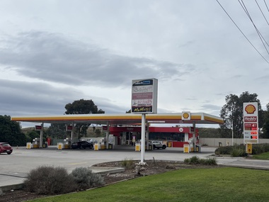
Photograph - Kealba - Service Station Photographs, John Alchin, 2026
... Station...Kealba...Sunshine Avenue...5864.01 - Sunshine Avenue 100 Kealba - Shell Service Station 2026.jpeg 5864.02 - Sunshine Avenue Cnr Main Road East Kealba - Ampol Service Station.jpeg...Service Station Kealba Sunshine Avenue 5864.01 - Sunshine Avenue 100 Kealba - Shell Service Station 2026.jpeg 5864.02 - Sunshine Avenue Cnr Main Road East Kealba - Ampol Service Station.jpeg Collection of digital colour photographs Photograph Kealba - Service Station Photographs John Alchin ...Collection of photographs of current and former service stations in the Kealba area.5864.01 - Sunshine Avenue 100 Kealba - Shell Service Station 2026.jpeg 5864.02 - Sunshine Avenue Cnr Main Road East Kealba - Ampol Service Station.jpegservice station, kealba, sunshine avenue -
 Sunshine and District Historical Society Incorporated
Administrative record - City of Sunshine - Commissioner Mr Alexander Alex George Gillon Collection 1976 - 1982 - Report of committee meetings 10th March 1981, City of Sunshine, 10th March 1981
... Station Road...Deer Park Hall...Alice Street...Sunshine...King Edward Avenue...Purchase of Land Randall Street Maribyrnong Claim Proceeds Land Sale Road Clouser Hyland Street Deer Park Rates, Sanitary & Interest Statements as at 9th February 1981 3 Alice Street Sunshine Sunshine Swimming Pool Sunshine Croquet Club Playground King Edward Avenue Albion 88 Station Road Deer Park Northern Pigeon Club Shed sue Errington Reserve Access to property 8 and 10 Warrs Road Maribyrnong Wallace Street reconstruction Right of Way Sydney Street Albion Albion Tennis Club request for additional land in the proposed lease Deer Park Hall painting Municipal Offices Extensions...Albans Albion Tennis Club Sydney Street Wallace Street Maidstone Sunshine Croquet Club Sunshine Swimming Pool Kennedy Street Sunshine Municipal Offices Alexandra Avenue Purchase of Land Randall Street Maribyrnong Claim Proceeds Land Sale Road Clouser Hyland Street Deer Park Rates, Sanitary & Interest Statements as at 9th February 1981 3 Alice Street Sunshine Sunshine Swimming Pool Sunshine Croquet Club Playground King Edward Avenue Albion 88 Station Road Deer Park Northern Pigeon Club Shed sue Errington Reserve Access to property 8 and 10 Warrs Road Maribyrnong Wallace Street reconstruction Right of Way Sydney Street Albion Albion Tennis Club request for additional land in the proposed lease Deer Park Hall painting Municipal Offices Extensions Foolscap sized document. ...Purchase of Land Randall Street Maribyrnong Claim Proceeds Land Sale Road Clouser Hyland Street Deer Park Rates, Sanitary & Interest Statements as at 9th February 1981 3 Alice Street Sunshine Sunshine Swimming Pool Sunshine Croquet Club Playground King Edward Avenue Albion 88 Station Road Deer Park Northern Pigeon Club Shed sue Errington Reserve Access to property 8 and 10 Warrs Road Maribyrnong Wallace Street reconstruction Right of Way Sydney Street Albion Albion Tennis Club request for additional land in the proposed lease Deer Park Hall painting Municipal Offices Extensionsrandall street, warrs road, maribyrnong, hyland street, station road, deer park hall, alice street, sunshine, king edward avenue, albion, northern pigeon club, errington reserve, main road east, st. albans, albion tennis club, sydney street, wallace street, maidstone, sunshine croquet club, sunshine swimming pool, kennedy street, sunshine municipal offices, alexandra avenue -
 Sunshine and District Historical Society Incorporated
Document - City Of Brimbank C84 Heritage And Plannng Scheme Amendment Documents
... 3837.01 - Brimbank City Council Heritage Policy 3837.02 - Brimbank City Council C84 Brimbank Heritage Amendment Explanatory Report Introduction Letter 2005 3837.03 - Brimbank City Council C84 Brimbank Heritage Amendment Explanatory Report 2005 3837.04 - Brimbank City Council C84 Brimbank Heritage Amendment Housing Estates - Commonwealth Munitions Housing Estate, Concrete Housing Estate Leith Avenue Sunshine , ICI Heritage Area Ballarat Road Deer Park, ICI Housing Estate Station Road Deer Park, McKay Housing Estate Durham Road Sunshine, McKay Housing Estate King Edward Avenue Albion, Railway Station Estate Sunshine & War Services Homes Albion 3837.05 - Brimbank City Council Schedule To The Heritage Overlay...City of Brimbank Hertiage 3837.01 - Brimbank City Council Heritage Policy 3837.02 - Brimbank City Council C84 Brimbank Heritage Amendment Explanatory Report Introduction Letter 2005 3837.03 - Brimbank City Council C84 Brimbank Heritage Amendment Explanatory Report 2005 3837.04 - Brimbank City Council C84 Brimbank Heritage Amendment Housing Estates - Commonwealth Munitions Housing Estate, Concrete Housing Estate Leith Avenue Sunshine , ICI Heritage Area Ballarat Road Deer Park, ICI Housing Estate Station Road Deer Park, McKay Housing Estate Durham Road Sunshine, McKay Housing Estate King Edward Avenue Albion, Railway Station Estate Sunshine & War Services Homes Albion 3837.05 - Brimbank City Council Schedule To The Heritage Overlay Collection of documents relating to City Of Brimbank C84 Heritage And Plannng Scheme Amendment Documents Document City Of Brimbank C84 Heritage And Plannng Scheme Amendment Documents ...3837.01 - Brimbank City Council Heritage Policy 3837.02 - Brimbank City Council C84 Brimbank Heritage Amendment Explanatory Report Introduction Letter 2005 3837.03 - Brimbank City Council C84 Brimbank Heritage Amendment Explanatory Report 2005 3837.04 - Brimbank City Council C84 Brimbank Heritage Amendment Housing Estates - Commonwealth Munitions Housing Estate, Concrete Housing Estate Leith Avenue Sunshine , ICI Heritage Area Ballarat Road Deer Park, ICI Housing Estate Station Road Deer Park, McKay Housing Estate Durham Road Sunshine, McKay Housing Estate King Edward Avenue Albion, Railway Station Estate Sunshine & War Services Homes Albion 3837.05 - Brimbank City Council Schedule To The Heritage Overlaycity of brimbank, hertiage -
 Sunshine and District Historical Society Incorporated
Document - Brimbank City Council Heritage Design Guidelines, Brimbank City Council, C 2009 or later
... General Guidelines|HO19 Commonwealth Munitions Housing estate Sunshine|HO20 Concrete Housing Estate Sunshine|HO21 ICI Residental Area Deer Park|HO22 Sunshine Commercial Area Sunshine|HO23 McKay Housing Estate Durham Road Sunshine|HO23 McKay Housing Estate King Edward Avenue Albion|HO25 Railway Station Estate Sunshine|HO26 War Service Homes Estate Albion...Brimbank City Council Heritage General Guidelines|HO19 Commonwealth Munitions Housing estate Sunshine|HO20 Concrete Housing Estate Sunshine|HO21 ICI Residental Area Deer Park|HO22 Sunshine Commercial Area Sunshine|HO23 McKay Housing Estate Durham Road Sunshine|HO23 McKay Housing Estate King Edward Avenue Albion|HO25 Railway Station Estate Sunshine|HO26 War Service Homes Estate Albion Brimbank Heritage Design Guidelines Document Brimbank City Council Heritage Design Guidelines Brimbank City Council ...General Guidelines|HO19 Commonwealth Munitions Housing estate Sunshine|HO20 Concrete Housing Estate Sunshine|HO21 ICI Residental Area Deer Park|HO22 Sunshine Commercial Area Sunshine|HO23 McKay Housing Estate Durham Road Sunshine|HO23 McKay Housing Estate King Edward Avenue Albion|HO25 Railway Station Estate Sunshine|HO26 War Service Homes Estate Albionbrimbank city council, heritage -
 Surrey Hills Historical Society Collection
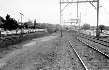
Photograph, Surrey Hills Station and car park
... station buildings were demolished and replaced by buildings constructed from concrete bricks and a second subway replaced the overhead footbridge. According to Roderick Smith, a local railway enthusiast, originally there had been 3 railway houses at the Mont Albert end of the northern car park. These were demolished to extend the car park. Certainly 8 Bedford Avenue...station buildings were demolished and replaced by buildings constructed from concrete bricks and a second subway replaced the overhead footbridge. According to Roderick Smith, a local railway enthusiast, originally there had been 3 railway houses at the Mont Albert end of the northern car park. These were demolished to extend the car park. Certainly 8 Bedford Avenue ...There are 3 tracks; the third track was built in 1971, which gives an approximate date for the photo. At this time the original station buildings were demolished and replaced by buildings constructed from concrete bricks and a second subway replaced the overhead footbridge. According to Roderick Smith, a local railway enthusiast, originally there had been 3 railway houses at the Mont Albert end of the northern car park. These were demolished to extend the car park. Certainly 8 Bedford Avenue, built as the station master's house was demolished at this time. The palm tree had been planted in the station master's front garden and was retained in a small garden bed within the car park. A black and white photograph of a station with cars parked on both sides of the 3 tracks. A Harris train is departing the station heading towards Mont Albert. A palm tree is prominent in the station car park to the north.1971, surrey hills station, railway stations, car parks, public transport, trains, railway lines, palm tree -
 Ringwood and District Historical Society
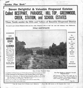
Pamphlet, Land Sale Brochure Titled Eureka Plan Book - Seven Delightful & Valuable Ringwood Estates - circa 1925
... Plan of Bestpart Estate, Ringwood, includes Bedford Road, Wilana Street, Greenwood Avenue, Caroline Street, Henry Street and Haig Street. Plan of Ringwood Station Estate includes Pitt Street, Bedford Road, Greenwood Avenue, Station Street, William Street (later Kendall Street, James Street, Wantirna Road, Caroline Street, Henry Street, Ellison Street and Haig Street. ...Plan of Bestpart Estate, Ringwood, includes Bedford Road, Wilana Street, Greenwood Avenue, Caroline Street, Henry Street and Haig Street. Plan of Ringwood Station Estate includes Pitt Street, Bedford Road, Greenwood Avenue, Station Street, William Street (later Kendall Street, James Street, Wantirna Road, Caroline Street, Henry Street, Ellison Street and Haig Street. ...Twenty page land sale brochure including photographs, subdivision features and local facilities. Additional flyer with conditions of sale and prices for estate blocks.Seven delightful and valuable Ringwood Estates called Bestpart, Paradise, Hill Top, Greenwood, Creek, Station, and School Estates. These nestle amidst the hills and valleys of beautiful Ringwood district. Also Goodluck Estate at Clarinda. Pamphlet marked as being From Mr. Farmer, No. 5 Flinders Court, Melbourne. Phone 988, 989 Central, or 55 Ringwood after 7 p.m. Plan of Ringwood School Estate includes William Street (later Kendall Street), Greenwood Avenue, Alton Street and Locke Street. Plan of Bestpart Estate, Ringwood, includes Bedford Road, Wilana Street, Greenwood Avenue, Caroline Street, Henry Street and Haig Street. Plan of Ringwood Station Estate includes Pitt Street, Bedford Road, Greenwood Avenue, Station Street, William Street (later Kendall Street, James Street, Wantirna Road, Caroline Street, Henry Street, Ellison Street and Haig Street. Plan of Geenwood Estate, Ringwood, includes Prussian Road (later Geenwood Avenue). Plan of Paradise Estate, Ringwood, includes Canterbury Road, Dandenong Road (Wantirna Road), Luck Street and Paradise Road. Plan of Creek Estate, Ringwood, includes Dandenong Creek, Wantirna Road and Gordon Crescent. Plan of Hill Top Estate, Ringwood (later Heathmont area), includes Heathmont Railway Station, Heathmont Road, Balfour Avenue, Lilian Street, Edith Street, Edna Street and Great Ryrie Street. Plan of Goodluck Estate, Clarinda, includes Talbot Avenue, Good Street, Luck Street, and Centre Road in locality plan between Oakleigh and Clayton Railway Stations. -
 Ringwood and District Historical Society
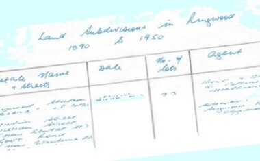
Document - Research Notes, Richard Carter, Land Subdivisions in Ringwood 1890-1950
... - after 1922) Lisgoold Street, Viviani Crescent, Balrour Avenue, Station Street (now part Heathmont Road and part Wainui Street) Pg13 RINGWOOD RAILWAY ESTATE LP10507 (1923) Whitehorse Road, Sherbrooke Avenue, Burwood Avenue, Bonview Avenue, Heatherbrae Avenue, Grant Crescent Pg14 GARDEN HOMES ESTATE (LP?) ...- after 1922) Lisgoold Street, Viviani Crescent, Balrour Avenue, Station Street (now part Heathmont Road and part Wainui Street) Pg13 RINGWOOD RAILWAY ESTATE LP10507 (1923) Whitehorse Road, Sherbrooke Avenue, Burwood Avenue, Bonview Avenue, Heatherbrae Avenue, Grant Crescent Pg14 GARDEN HOMES ESTATE (LP?) ...Handwritten table listing main local pre-1950s subdivisions in the Ringwood area, with estate names, streets, number of allotments for sale, and where known, vendor agent, LP (Lodged Plan) title registration number, and auction/sale date, some with sale price.Pg1 RINGWOOD STATION ESTATE LP3070 (Year?) Station Street, William Street (now Kendall Street), Wantirna Road, Station Street Pg1 RINGWOOD TOWNSHIP ESTATE LP5577 (1913) Station Road (now Warrandyte Road), Pratt Street (part now Aird Street), Whitehorse Road Pg2 RINGWOOD ORCHARD ESTATE LP4315 (1914) Brysons Road, Hillcrest Road, Anzac Avenue, Sulva Road Pg3 RINGWOOD RAILWAY ESTATE LP7522 (1918) Whitehorse Road (now Mount Dandenong Road), Dublin Road, Freeman Street, Patterson Street, Bona Street Pg4 THE RINGWOOD ESTATE LP7578 (1919) Warrandyte Road, Hobart Street, Paxton Street, Arnold Street Pg5 GARDEN FARMS ESTATE (LP?) (1919) Canterbury Road, Armstrong Road, Bungalook Road, Orchard Road, Bayswater Road (now Mountain Highway) Pg6 THE RINGWOOD ESTATE (SECOND SUB-DIVISION) LP7604 (1919) Warrandyte Road, Tamar Street, Derwent Street, Mersey Street Pg7 RINGWOOD STATION ESTATE LP7703 (1919) Bedford Road, Williams Grove (now Lena Grove) Pg8 RINGWOOD TOWNSHIP ESTATE LP8198 (1919) Wantirna Road, Ellison Street, Haig Street, Greenwood Avenue Pg9 EASTFIELD ESTATE (LP?) (1920) Eastfield Road, Longview Road, Pleasant Rise, The Mount Pg10 ELECTRIC RAILWAY ESTATE RINGWOOD LP9473 (1922) Campbell Street, Myrtle Avenue, George Street (now Tudor Court), Henry Street (now Myrtle Avenue), Williams Grove (now Lena Grove) Pg11 RINGWOOD PARK ESTATE LP7884 (1922 - two stages) Wonga Road (now Loughnan Road), William Street, Andrew Street, Harrison Street Pg12 HEATHMONT STATION ESTATE LP11009 (Date? - after 1922) Lisgoold Street, Viviani Crescent, Balrour Avenue, Station Street (now part Heathmont Road and part Wainui Street) Pg13 RINGWOOD RAILWAY ESTATE LP10507 (1923) Whitehorse Road, Sherbrooke Avenue, Burwood Avenue, Bonview Avenue, Heatherbrae Avenue, Grant Crescent Pg14 GARDEN HOMES ESTATE (LP?) (1923) Mullum Road, The Centreway, Wattle Crescent (now Wattle Avenue) Reserve Crescent (now Reserve Road) Pg15 DUBLIN ROAD ESTATE LP11993 (1923) Alexandra Road, Vonadawn Avenue, Green Street, Wood Street, Howard Avenue, Bedford Road, Dublin Road Pg16 CARLINGA ESTATE RINGWOOD LP9620 (1923) Bourke Street, Bond Street, Ringwood Street Pg17 PRATT'S JUNCTION ESTATE (LP?) (1923) Junction Street, Georges Road, Oliver Street, Whitehorse Road Pg18 EAST RINGWOOD ESTATE LP10492 (1923) Bona Street, Patterson Street, Miller Grove, Fairview Avenue, Eastfield Road, Whitehorse Road (now Mount Dandenong Road) Pg19 COLEMAN'S HEATHMONT ESTATE LP9974 (1923) Canterbury Road, Bedford Road, Alvena Crescent, Coleman Street, Leonard Street (now Royal Avenue) Pg20 RINGWOOD HEIGHTS ESTATE LP10506 (1924) Whitehorse Road, Bonview Avenue, Grant Crescent, Hillcrest Avenue, Heatherbrae Avenue, Margaret Street, Mary Street Pg21 EAST RINGWOOD STATION ESTATE LP10551 (1924) Knaith Road, Wenwood Street, Lois Street, Victoria Street, Station Street (now Railway Avenue) Pg22 GRAND VIEW ESTATE LP11019 (1924) Whitehorse Road, Rupert Street, Herbert Street, Leonard Street Pg23 RINGWOOD RAILWAY ESTATE & RINGWOOD HEIGHTS ESTATE - FINAL SECTIONS LP10506 & LP10507 (1924) Whitehorse Road, Sherbrooke Avenue, Burwood Avenue, Bonview Avenue, Heatherbrae Avenue, Margaret Street, Mary Street, Grant Crescent Pg24 RINGWOOD EAST ELECTRIC STATION ESTATE (LP?) (1924) Railway Parade (now Patterrson Street), Federal Road, Howship Avenue (part now French Street), Dublin Road, Rosedale Crescent Pg25 BEDFORD PARK (now Ringwood Secondary College) (LP?) (1924) Bedford Road, Adams Street, Anderson Street, Joyce Street, Graham Road Pg26 CROWN JEWEL ESTATE LP11645 (Private sales after 1924) Mount Dandenong Road, Mirabel Avenue, Valda Avenue, Evon Avenue, Velma Grove Pg27 GRAND CENTRAL ESTATE LP10917 (1925) Heathmont Road, Great Ryrie Street, Douglas Street, Garden Street, Bellevue Avenue Pg28 RINGWOOD (unnamed estate - 1926) Nelson Street, Seymour Street, Whitehorse Road Pg29 EAST RINGWOOD RAILWAY STATION ESTATE (YEAR? - 25 shops 60 villas) Railway Avenue, Dublin Road, Lawrence Grove, Stanley Avenue, Knaith Road Pg30 CHARM VIEW ESTATE (LP?) (year? - after 1926) Canterbury Road, Heathmont Road, Dickasons Road, Bennjett Avenue, Orchid Street Pg31 SUNBEAM ESTATE LP12150 (Circa 1925) Govt Road (now Old Lilydale Road), Sunbeam Avenue, Holland Road, Everard Street (now Everard Road) Pg32 FAIRVIEW ESTATE EAST RINGWOOD LP10853 (Circa 1924) Eastfield Road, Patterson Street, Margaret Street (now Short Street) Pg33 EAST RINGWOOD TOWNSHIP ESTATE LP3025 (Circa 1924 - 35 allotments) Mount Dandenong Road, Grey Street, Eastfield Road Pg34 EAST RINGWOOD TOWNSHIP ESTATE LP3025 (Circa 1924 - 49 allotments) and STATE SCHOOL ESTATE (26 allotments) and EAST RINGWOOD STATION ESTATE (14 shop sites) Mount Dandenong Road, Grety Street, Dunn Street, Eastfield Road, King Street, Holland Road, Dublin Road, Patterson Street, Bona Street Pg35 EAST RINGWOOD CENTRAL ESTATE LP17004 (1948) Knaith Road, Shasta Avenue, Talofa Avenue, Russet Road, Dublin Road Pg36 WARE ESTATE LP43360 (1958) Ware Crescent, Davey Drive, Grey Road (now Grey Street), Mount Dandenong Road Pg37 Lot 57 Kendall Street LP3070 (1939) £75.0.0 Pg37 Lot 14 LP7346 (year?) £225 Pg37 Lot 8 WHITE HORSE ESTATE LP14010 (year?) Maroondah Hwy, Seymour Street £98.9.0 Pg37 Lots 4-14 incl. LP10902 (year?) £300 Pg37 Lots 69&70 LP2216 (1939) Bedford Road, Pitt Street £500 Pg37 Lots 60&70 LP2216 (year?) £460 Pg37 MOUNTAIN VIEW ESTATE LP10902 (1936) Lots 1&2, 19-22 Wantirna Road, Daisy Street £50 Pg38 RAILWAY STATION ESTATE RINGWOOD EAST LP7522 (1925) Lots 16 to 19 £250 Pg38 RINGWOOD PARK ESTATE (LP?) (1924) Lot 112 Munro Street £230 Pg38 RINGWOOD TOWNSHIP ESTATE (LP?) (1925) Lot 57 Wantirna Road £850 Pg38 ELECTRIC RAILWAY ESTATE LP9473 (1925) Lot 98 & 99 £180 (30/- foot) Pg38 ELECTRIC RAILWAY ESTATE LP9473 (year?) Lot 100 £233.12.6 incl improvements (£2.12.6 foot) Pg38 Lot 22&23 Bedford Road Heathmont (LP & year?) £675 incl improvements Pg39 Lot 9 Mullum Mullum Road LP8221 (1923) £150 Pg39 Lot 27 Haig Street LP8198 (1925) £825 Pg39 Lot 56 Haig Street cnr Wantirna Road LP8198 (1923) £171 Pg39 Lots 3 & 4 Loughnan Road LP9626 (192?) £147 Pg39 Lots 98 & 99 Myrtle Avenue LP9473 (1925) £180 Pg39 Lots 80 & 81 Myrtle Avenue LP9473 (1929) £150 Pg39 Lot 30 Sherbrooke Avenue LP10507 (1926) £700 incl improvements Pg40 Lot 10 (year?) LP7703 £750 Pg40 Lot 36 (year?) LP7522 £25 Pg40 Lot 38 Pitt Street LP2216 (year?) £350 Pg40 Lot 7 Dublin Road cnr Green Street LP11993 (year?) £300 -
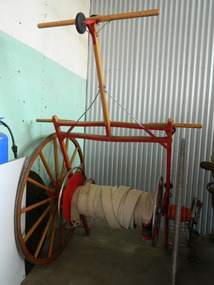 Kiewa Valley Historical Society
Fire Hose Reel, c1950s
... The practice strip was located beside the fire station in Lakeside Avenue. This fire hose reel was used by the Mt Beauty Fire Brigade for demonstrations at competitions during the 1950's and 1960's. ...The practice strip was located beside the fire station in Lakeside Avenue. This fire hose reel was used by the Mt Beauty Fire Brigade for demonstrations at competitions during the 1950's and 1960's. ...The fire hose reel was purchased by the Fire Ladies' Auxiliary for the Mt Beauty S.E.C. Fire Brigade in the late 1950's for over 1000 pounds. Initially they competed with Bogong fire brigade as both were 'Industry' Fire brigades - both owned by the State Electricity Commission. Competition was at 2 levels - north east Victoria and state competitions involving rural and urban brigades with a difference in the equipment. Mt Beauty was/is an urban brigade whereas Tawonga is a rural brigade. Competition involved members to improve their skill, keep fit and was a very social occasion. After the Shire took over Mt Beauty township in 1961, the Fire Brigade ran by itself but soon became affiliated with the C.F.A. because of insurance and legal liability e.g.. enabling them to stop traffic or wreck buildings if required. The CFA were not happy with the Mt Beauty truck so a new one was obtained while the old one went to Bogong. Competitions gradually ceased as it was a young man's sport and young members had prior commitments. The reel was donated to the KVHS in the mid 1980's as it failed to be sold as it competed with new, cheaper, aluminium reels. The practice strip was located beside the fire station in Lakeside Avenue. This fire hose reel was used by the Mt Beauty Fire Brigade for demonstrations at competitions during the 1950's and 1960's. The Mt Beauty Fire Brigade Team won the competition in 1966 at Wangaratta. The score was close against the home team and was decided on a play off. The team benefitted by the man who wound the hose on allowing it to end up at the easiest height to handle when full of water and very heavy.The Mt Beauty Fire Brigade was an 'industry' fire brigade belonging to the State Electricity Commission of Victoria from the 1940's. It became a member of the Country Fire Authority in the early 1960's. During the 1950's and early 1960's members would compete with other local fire brigades in competitions against other brigades in the north east of Victoria using skills such as unwinding the hose off the reel and turning on the water in record time. The Mt Beauty Fire Brigade continues today as an urban fire brigade affiliated with the CFA.Varnished wooden cart reinforced by painted red steel frame. The wheels have 14 wooden spokes and steel around the outside of the wooden wheel. A long canvas hose is wound around a central winding cylinder. The cart has a wooden handle with a rubber jockey wheel at its end. There is a brass hose nozzle attached by a stainless steel frame on the outer side near one of the wheels.Each Reel: "Mt Beauty F.B." yellow print outlined in black with red background.fire hose. mt beauty fire brigade. country fire authority. fire reel. -
 Victoria Police Museum
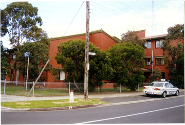
Police Stations (Altona North)
... Altona North Police Station opened on 7 October 1979 as a new twenty-four police station and was the District Headquarters of Altona District. It comprised a C.I.B. and a Community Policing Squad. It is located at 72 Cooper Avenue...Altona North Police Station opened on 7 October 1979 as a new twenty-four police station and was the District Headquarters of Altona District. It comprised a C.I.B. and a Community Policing Squad. It is located at 72 Cooper Avenue ...Altona North is a suburb of Melbourne, Victoria, Australia, 10 km south-west of Melbourne's Central Business District, located within the City of Hobsons Bay local government area. Altona North Police Station opened on 7 October 1979 as a new twenty-four police station and was the District Headquarters of Altona District. It comprised a C.I.B. and a Community Policing Squad. It is located at 72 Cooper Avenue, on the corner of McArthurs Road. A new police station is being planned for Galvin Street, opening in 2020.2 colour photospolice stations; altona north police station -
 Federation University Historical Collection
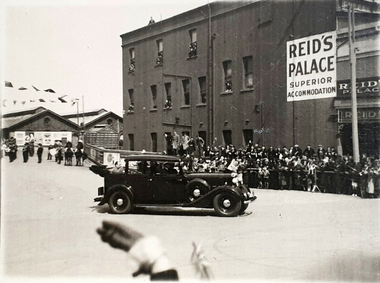
Photograph, Reid's Coffee Palace, Lydiard Street, Ballarat, c1930s ?
... Avenue of Honour? There is a band in the background. Note the folded back roof which allows the passenger to be seen by the public. https://architectureau.com/articles/heritage-listed-gold-rush-era-ballarat-coffee-palace-receives-700000-conservation-grant/ reid's coffee palace ballarat railway station visitor bunting celebration Ballarat Verso - Post (Correspondence) Black and white photos of a car leaving the Ballarat Station (possibly carrying William Birdwood?). ...The special guest in the car appears to have arrived in Ballarat by train. Could it be William Birdwood to plant trees in the Ballarat Avenue of Honour? There is a band in the background. Note the folded back roof which allows the passenger to be seen by the public. https://architectureau.com/articles/heritage-listed-gold-rush-era-ballarat-coffee-palace-receives-700000-conservation-grant/Black and white photos of a car leaving the Ballarat Station (possibly carrying William Birdwood?). Reid's Coffee Palace is in the background Verso - Post (Correspondence)reid's coffee palace, ballarat railway station, visitor, bunting, celebration, ballarat -
 Bright & District Historical Society operating the Bright Museum
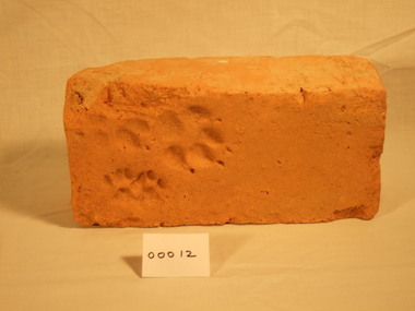
Brick, handmade
... Bright & District Historical Society operating the Bright Museum 2 Station Street Bright high-country Henry Oakes' kiln was located near the current council depot in Churchill Avenue,Bright. handmade brick oakes kiln Animal paw prints- 2 sets. ...Henry Oakes' kiln was located near the current council depot in Churchill Avenue,Bright.Handmade brick of pale orange clay. Two corners damaged.Animal paw prints- 2 sets.handmade, brick, oakes, kiln -
Federation University Historical Collection
Report, Cultural Landscapes Study of Creswick Goldfields Area for Australian Hertiage Commission
... station...creswick school of forestry...sawpit gully...oak gully...creswick cemetery...kingston...creswick avenue...Barker Library (top floor) Mount Helen goldfields goldfields of victoria goldfields tourism marketing tourism creswick creswick goldfields allendale broomfield rocklyn bullengarook mollongghip dean scrub hill clarkes hill creswick railway station creswick school of forestry sawpit gully oak gully creswick cemetery kingston creswick avenue of honour kerrins bridge berry deep leads mine system australasian mine site creswick alluvial workings calembeen park ascot anderson's mill smeaton hepburn lagoon White bound report with clear cover Cultural Landscapes Study of Creswick Goldfields Area for Australian Hertiage Commission Report Chris McConville Chris Olver ...White bound report with clear covergoldfields of victoria, goldfields tourism, marketing, tourism, creswick, creswick goldfields, allendale, broomfield, rocklyn, bullengarook, mollongghip, dean, scrub hill, clarkes hill, creswick railway station, creswick school of forestry, sawpit gully, oak gully, creswick cemetery, kingston, creswick avenue of honour, kerrins bridge, berry deep leads mine system, australasian mine site, creswick alluvial workings, calembeen park, ascot, anderson's mill, smeaton, hepburn lagoon -
 Eltham District Historical Society Inc
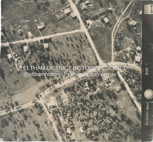
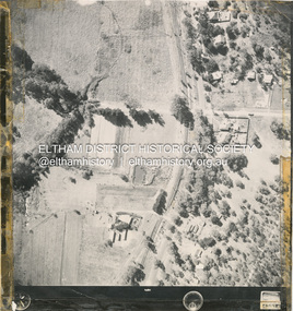
Photograph - Aerial Photograph, Main Road, intersection Grand Boulevard and Panorama Avenue, Lower Plenty / Montmorency, 2 Jul. 1951
... Station...Beleura Grove...Grand Boulevard...Looker Road...Lower Plenty...Montmorency...Panorama Avenue...Eltham District Historical Society Inc 728 Main Rd Eltham melbourne Not originally catalogued in Shire of Eltham Archives but from the same series of photos taken for Country Road Board study of Main Road widening shire of eltham archives Aerial Photo Country Roads Board Eltham Main Road Road widening 1951-07 Airlie Road Ambulance Station Beleura Grove Grand Boulevard Looker Road Lower Plenty Montmorency Panorama Avenue Black and white proto print Size: 245x230 mm Condition: good Main Road, intersection Grand Boulevard and Panorama Avenue, Lower Plenty / Montmorency Photograph Aerial Photograph ...Not originally catalogued in Shire of Eltham Archives but from the same series of photos taken for Country Road Board study of Main Road wideningshire of eltham archives, aerial photo, country roads board, eltham, main road, road widening, 1951-07, airlie road, ambulance station, beleura grove, grand boulevard, looker road, lower plenty, montmorency, panorama avenue -
 Eltham District Historical Society Inc
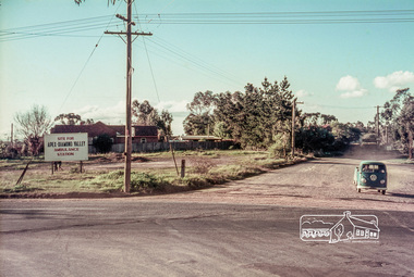
Slide, Site for the new Apex-Diamond Valley Ambulance Station, corner of Main Road and Grand Boulevard, Montmorency, July 1969, 1969
... View looking west along Grand Boulevard from the intersection with Main Road and Panorama Avenue, Montmorency showing the site for the new Apex-Diamond Valley Ambulance Station and before construction of Apex Way, July 1969. ...Eltham District Historical Society Inc 728 Main Rd Eltham melbourne View looking west along Grand Boulevard from the intersection with Main Road and Panorama Avenue, Montmorency showing the site for the new Apex-Diamond Valley Ambulance Station and before construction of Apex Way, July 1969. ...View looking west along Grand Boulevard from the intersection with Main Road and Panorama Avenue, Montmorency showing the site for the new Apex-Diamond Valley Ambulance Station and before construction of Apex Way, July 1969. The Eltham Apex Club conducted a Community Service Project (1965-1968) to raise funds for a new Ambulance Station to service the community. A site bounded by the intersection of Main Road, Grand Boulevard and Looker Road at Montmorency was purchased in 1969. In 1970, Eltham Shire Council undertook roadworks to construct Apex Way in preparation for the new station as well as duplicate Main Road, Lower Plenty, east of Grand Boulevard including the new Lower Plenty Bridge, which had been opened in November 1966, bordering with the City of Heidelberg.35 mm colour positive transparency Mount - Agfacolor Service (Blue)1969-07, ambulance station, apex way, grand boulevard, lower plenty, main road, montmorency, eltham ambulance station, apex-diamond valley ambulance station, eltham apex club -
 Eltham District Historical Society Inc
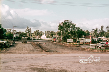
Slide, Reconstruction of Grand Boulevard viewed from Panorama Avenue, Montmorency, 18 August 1970, 1970
... In 1970, Eltham Shire Council undertook roadworks to construct Apex Way in preparation for the new station as well as duplicate Main Road, Lower Plenty, east of Grand Boulevard including the new Lower Plenty Bridge, which had been opened in November 1966, bordering with the City of Heidelberg. 1970-08-18, Apex-Diamond Valley Ambulance Station, Eltham Ambulance Station, Eltham Apex Club, Grand Boulevard, Montmorency 35 mm colour positive transparency Mount - Agfacolor Service (Blue) Reconstruction of Grand Boulevard viewed from Panorama Avenue, Montmorency, 18 August 1970 Slide ...The Eltham Apex Club conducted a Community Service Project (1965-1968) to raise funds for a new Ambulance Station to service the community. A site bounded by the intersection of Main Road, Grand Boulevard and Looker Road at Montmorency was purchased in 1969. In 1970, Eltham Shire Council undertook roadworks to construct Apex Way in preparation for the new station as well as duplicate Main Road, Lower Plenty, east of Grand Boulevard including the new Lower Plenty Bridge, which had been opened in November 1966, bordering with the City of Heidelberg.35 mm colour positive transparency Mount - Agfacolor Service (Blue)1970-08-18, apex-diamond valley ambulance station, eltham ambulance station, eltham apex club, grand boulevard, montmorency -
 Eltham District Historical Society Inc
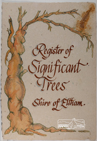
Work on paper - Folio, Register of Significant Trees, Shire of Eltham, c.1993
... Station. Its origins may have been similar to Donaldson's Oak, and as a young tree it apparently slipped from higher up the hill during wet weather. Both oaks are of local historical importance. 3. Eucalyptus globulus (Blue Gum). A large mature specimen at the corner of the Kangaroo Ground-St. Andrews Road and Bakehouse Road, Panton Hill. 4. Plantanas acerifolia (Plane tree) A number of trees forming the Avenue...Station. Its origins may have been similar to Donaldson's Oak, and as a young tree it apparently slipped from higher up the hill during wet weather. Both oaks are of local historical importance. 3. Eucalyptus globulus (Blue Gum). A large mature specimen at the corner of the Kangaroo Ground-St. Andrews Road and Bakehouse Road, Panton Hill. 4. Plantanas acerifolia (Plane tree) A number of trees forming the Avenue ...In 1983, the National Trust advised the Shire of Eltham that it was investigating a number of trees within the shire which had been nominated for recording the Register of Significant Trees of Victoria. The trees involved were described in the Shire of Eltham Historical Society Newsletter No. 29, March 1983 as follows:- 1. Eucalyptus melliadora (Yellow box) . a) An outstanding mature specimen 42 metres high in Laughing Waters Road, Eltham. b) Another mature specimen in Arthurs Creek road, Hurstbridge is reported to be the tree under which the bushranger Robert Bourke was tied after he shot and killed Henry Hurst in 1866 . 2. Quercus robur (English Oak). a) "Donaldson's Oak", Donaldsons Road, Kangaroo Ground was planted by John Donaldson from seed collected from Windsor Great Park in 1878. b) "Wippells Oak". This now misshapen tree is located on the St. Andrews Road near the Kangaroo Ground Fire Station. Its origins may have been similar to Donaldson's Oak, and as a young tree it apparently slipped from higher up the hill during wet weather. Both oaks are of local historical importance. 3. Eucalyptus globulus (Blue Gum). A large mature specimen at the corner of the Kangaroo Ground-St. Andrews Road and Bakehouse Road, Panton Hill. 4. Plantanas acerifolia (Plane tree) A number of trees forming the Avenue of Honour to Eltham's First World War soldiers along Main Road between Dalton and Pitt Streets, Eltham. 5. Pinus canariensis (Canary Island Pine), Pinus pinea, (Stone pine) and Cedras altlantica, (Cedar) These trees are located at the Hurst family graves in the grounds of the Hurstbridge Pre-school Centre. In 1991 the Shire of Eltham introduced controls into its planning scheme to protect sites of architectural, historic or conservation interest and significant trees. The controls were approved by the Minister for Planning and Housing. As advised in the Shire of Eltham Historical Society Newsletter No. 78, May 1991, a planning permit is required to demolish or alter any listed building or to destroy, lop or remove any listed tree. Provision is made for comments to be obtained from the National Trust or Historic Buildings Council in considering any applications. The buildings and trees listed were: Buildings: 250 Bolton Street Eltham (former Walter Withers home) "Rosehill" - Bonds Road Lower Plenty St Andrews Church of England - St Andrews "Montsalvat" - Hillcrest Avenue Eltham St Margarets Church and former vicarage - Pitt Street Eltham Presbyterian Church - Kangaroo Ground Parks and Environment Office (former police quarters) Main Road Eltham Former Court House - Main Road Eltham "Shillinglaw Cottage" - Main Road Eltham "The Robins" - Kangaroo Ground Road Warrandyte Trees: "Donaldsons Oak" - Donaldsons Road Kangaroo Ground Yellow Box - Laughing Waters Road Eltham Yellow Box - Arthurs Creek Road Hurstbridge Wippells Oak - St Andrews Road Kanqaroo Road Pines and Cedar - Hurst family cemetery Greysharps Road Hurstbridge Yellow Box - Parsons Road Eltham A large Blue Gum at Panton Hill has been listed but has recently died (1991). In 1993 work by Council Parks and Environment staff and volunteers resulted in the preparation of a Significant Tree Register listing forty-one trees or groups of trees. According to Shire of Eltham Historical Society Newsletter No. 91, March 1993, a similar number remained to be assessed for inclusion in the register. There is a wide range of indigenous and planted trees on private and public land and extending through the Shire of Eltham from Lower Plenty to Kinglake. Most can be viewed from publicly accessible locations. The Significant Tree Register lists 41 trees or groups of trees throughout the Shire. It contains a wide range of naturally occurring and planted trees. They have been assessed according to eleven criteria including size, age, rarity, historical value and the like. The list includes large old Red Gums at Lower Plenty, historic Oaks at Kangaroo Ground and Mountain Ash at Kinglake. The register includes a set of slides showing each tree. Garry Bartlett of the Council's Parks and Environment Section and Faye Shepherd were extensively involved in establishment of the register (Newsletter No. 93, November 1993). In 1999 Niliumbik planners prepared an amendment to the Planning Scheme to provide protection for approximately 200 of the places listed in the heritage studies and also in the Significant Tree Register commenced by the Eltham Council (Eltham District Historical Society Newsletter No. 127, July 1999. In 2004, The Register of Significant Trees was presented to the Eltham District Historical Society by Nillumbik Shire Council as part of a wider collection of of its memorabilia of the former Eltham Shire Council (EDHS Newsletter No. 159, July 2004. Album of loose handmade paper sheets contained within a handmade slip cover constructed of handcrafted card with encapsulated flora material (flowers, vines, ferns) and tinted. Each page also contains an embedded/adhered fern leaf also tinted with lacqueur or similar, text as appropriate in ink by hand calligraphy. Each page also has a white protective sheet cut to size and adhered to back surface with sticky tape and folded over face of page. Pages variously have photographs and coloured masks adhered with a gum resin. Over time much of this resin has let go and photos/masks have been reattached using acid free archival safe adhesive. 15 pages 41 x 29 cm inclusive of 3 blank pages. Slip case 42 x 30 x 1 cm; face cover of slip case has broken off at left hand margin as insufficient depth/flexibility for contents.arthurs creek road, blue gum (eucalyptus globulus), canary island pine (pinus canariensis), couties road, donaldsons oak, donaldsons road, eltham, english oak (quercus robur), eucalyptus melliodora, graysharps road, hurst tree, hurstbridge, ironbark (eucalyptus tricarpa), ironbark hill, kangaroo ground, kangaroo ground-kinglake road, laughing waters road, panton hill hotel, panton hill, parsons road, significant trees register, sonia van bodegraven, sonjart, stone pine (pinus pinea). atlantic cedar (cedrus atlantica), wippells oak, yellow box gum (eucalyptus melliodora), yellow box gum -
 Eltham District Historical Society Inc
Photograph - Aerial Photograph, Main Road Hurstbridge, corner of Rose Ave, 12 Apr. 1954
... Avenue...Hursbridge...Parker Road...Hurstbridge Railway Station...Eltham District Historical Society Inc 728 Main Rd Eltham melbourne Victorian Railways Aerial Survey shire of eltham archives Aerial Photo Main Road Anzac Avenue Hursbridge Parker Road Hurstbridge Railway Station Rose Road Black and white proto print; Size: 230x240 mm Condition: fair, sticky tape Main Road Hurstbridge, corner of Rose Ave Photograph Aerial Photograph ...Victorian Railways Aerial Surveyshire of eltham archives, aerial photo, main road, anzac avenue, hursbridge, parker road, hurstbridge railway station, rose road -
 Eltham District Historical Society Inc
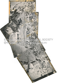
Photograph - Aerial Photograph, Main Road, Hurstbridge; Rose Road to Anzac Avenue including Railway Station area, 12 Apr. 1954
... Main Road, Hurstbridge; Rose Road to Anzac Avenue including Railway Station area...Avenue...Hursbridge...Parker Road...Hurstbridge Railway Station...Eltham District Historical Society Inc 728 Main Rd Eltham melbourne Victorian Railways Aerial Survey shire of eltham archives Aerial Photo Main Road Anzac Avenue Hursbridge Parker Road Hurstbridge Railway Station Rose Road Digital panorama created from items 4-9 Main Road, Hurstbridge; Rose Road to Anzac Avenue including Railway Station area Photograph Aerial Photograph ...Victorian Railways Aerial Surveyshire of eltham archives, aerial photo, main road, anzac avenue, hursbridge, parker road, hurstbridge railway station, rose road