
Showing 5 items matching "bacchus marsh main street 19th century"
-
 Bacchus Marsh & District Historical Society
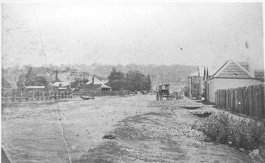
Photograph, Main Street Bacchus Marsh looking West, circa 1870
... Bacchus Marsh Views...Bacchus Marsh Main Street 19th Century...Bacchus Marsh is undated. Judging by the number and type of buildings which can be seen it probably dates from around the 1870s. This is one of the earliest street scenes of Bacchus Marsh. It is therefore of great significance in providing a photographic record of the township in its formative years. Bacchus Marsh Views Bacchus Marsh Main Street 19th Century ...This view of Bacchus Marsh is undated. Judging by the number and type of buildings which can be seen it probably dates from around the 1870s. This is one of the earliest street scenes of Bacchus Marsh. It is therefore of great significance in providing a photographic record of the township in its formative years.Original format: Black and white photograph. Undated. Format displayed: Digital image of original photograph.bacchus marsh views, bacchus marsh main street 19th century -
 Bacchus Marsh & District Historical Society
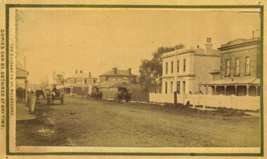
Photograph, Main Street Bacchus Marsh 1883 looking east
... ...Bacchus Marsh Main Street 19th Century...View of Main Street Bacchus Marsh 1883, showing early notable buildings on the southern side of the street, including the Courthouse, National Bank of Australasia, Border Inn, Hall of Commerce building. Stevenson and McNicoll 1883 Photographs of Bacchus Marsh and District Bacchus Marsh Roads and Streets Bacchus Marsh Main Street 19th Century On the front: Stevenson & McNicoll. ...View of Main Street Bacchus Marsh 1883, showing early notable buildings on the southern side of the street, including the Courthouse, National Bank of Australasia, Border Inn, Hall of Commerce building. Small sepia unframed photograph on card with gold border framing photograph. Housed in the album, 'Photographs of Bacchus Marsh and District in 1883 by Stevenson and McNicoll'. Several horse-drawn vehicles can be seen travelling along an unmade road. Piles of excavated dirt can be seen along the side of the road. Four substantial two-storeyed buildings can be seen along the southern side of the street.On the front: Stevenson & McNicoll. Photo. 108 Elizabeth St. Melbourne. COPIES CAN BE OBTAINED AT ANY TIME. On the back: LIGHT & TRUTH inscribed on a banner surmounted by a representation of the rising sun. Copies of this Portrait can be had at any time by sending the Name and Post Office Money Order or Stamps for the amount of order to STEVENSON & McNICOLL LATE BENSON & STEVENSON, Photographers. 108 Elizabeth Street, MELBOURNE. stevenson and mcnicoll 1883 photographs of bacchus marsh and district, bacchus marsh roads and streets, bacchus marsh main street 19th century -
![Map, Millbank Estate Bacchus Marsh Thursday 4th October 1888 [Land sales], 1924](/media/collectors/5e461d8021ea67224c82f2a1/items/67765662eb6d2cbd24e0797f/item-media/67765682eb6d2cbd24e07a41/item-fit-380x285.jpg?cb=6) Bacchus Marsh & District Historical Society
Bacchus Marsh & District Historical SocietyMap, Millbank Estate Bacchus Marsh Thursday 4th October 1888 [Land sales], 1924
... Bacchus Marsh which was sub-divided and offered for sale in 62? lots on the 4th October 1888. The lots had frontages to Ballarat Road (Main Street), Maddingley Road (now Grant Street), Turner Street, Millbank Street, Clarinda Road (now Clarinda Street), and an unnamed street south of Turner Street (possibly known as Grant Street at this time) which connected to Maddingley Road through the vicinity of the present day Bacchus Marsh Hospital. This was a significant sub-division of land and represented a major expansion of residential housing in Bacchus Marsh in the late 19th century...Bacchus Marsh which was sub-divided and offered for sale in 62? lots on the 4th October 1888. The lots had frontages to Ballarat Road (Main Street), Maddingley Road (now Grant Street), Turner Street, Millbank Street, Clarinda Road (now Clarinda Street), and an unnamed street south of Turner Street (possibly known as Grant Street at this time) which connected to Maddingley Road through the vicinity of the present day Bacchus Marsh Hospital. This was a significant sub-division of land and represented a major expansion of residential housing in Bacchus Marsh in the late 19th century ...The Millbank Estate was a parcel of land close to the centre of the shopping area of Bacchus Marsh which was sub-divided and offered for sale in 62? lots on the 4th October 1888. The lots had frontages to Ballarat Road (Main Street), Maddingley Road (now Grant Street), Turner Street, Millbank Street, Clarinda Road (now Clarinda Street), and an unnamed street south of Turner Street (possibly known as Grant Street at this time) which connected to Maddingley Road through the vicinity of the present day Bacchus Marsh Hospital. This was a significant sub-division of land and represented a major expansion of residential housing in Bacchus Marsh in the late 19th century. The map includes a wealth of detail about the time of the sale, where it will take place, who the selling agents were, the deposit terms for purchases and details of a special train from Melbourne to Bacchus Marsh on sale day. The location of the allotments in relation to the shopping and commercial area of Bacchus Marsh, Maddingley and the railway station are indicated on an inset map within the overall map and poster. The Millbank Estate area was an area which had once belonged to the Grant family who were prominent early citizens of Bacchus Marsh and lived in a house in this area known as 'Millbank'.This land sale map is a typical example of housing estate land sales advertising maps produced by real estate agents in this era. The map is significant for the detailed information it provides about when and where land was sold for new housing estates in Bacchus Marsh in the late nineteenth century.Single page map showing land allotments for sale at auction in Bacchus Marsh in October 1888. A significant portion of the map is missing from the bottom right side. land sales bacchus marsh, land subdivsion bacchus marsh, housing estates land sales bacchus marsh, grant family bacchus marsh, millbank estate land sales -
![Map, Plan of Town Allotments Bacchus Marsh [1873]](/media/collectors/5e461d8021ea67224c82f2a1/items/677a8ee7ab7bb47995c5573f/item-media/677a8fdeab7bb47995c55b56/item-fit-380x285.jpg?cb=6) Bacchus Marsh & District Historical Society
Bacchus Marsh & District Historical SocietyMap, Plan of Town Allotments Bacchus Marsh [1873]
... main street frontages, opposite the Border Flour Mills. The Auctioneer would also direct attention to the plan, showing the formation of a new thorough fare (Bennett street) leading from Young street into Gell street, thus opening up the township on the high, more healthy, and commanding position so much to be desired for private dwellings". An important cartographic document which indicates an early major subdivision of land in the inner urban area of the Bacchus Marsh township. This subdivision lead to the continuing residential and commercial development of the township of Bacchus Marsh in the later part of the 19th century ...James Young was a prominent businessman, land owner and public figure in the early colonial period of Bacchus Marsh. After his death in 1871 land remaining from his estate in Bacchus Marsh was sold at auction in 1873. The sale of his estate included the substantial stone residence in Bennett Street which later became known as 'Stone Villa'. The sale of his land in 1873 was conducted by local auctioneer James Crook. 29 allotments were advertised for sale, although the plan for the sale indicated 30 allotments. The sale notice in the Bacchus Marsh Express of 11 October 1873 noted that the allotments were " in the very centre and heart of the most populous and business portion of the township, at the same time being the only remaining portion of the business block available for purchase by public sale, which fact intending purchasers should not lose sight of, as the opportunity cannot occur again". The designation of a new street, 'Bennett Street', shown on the plan, is also indicated in the advertising, "In reference to the main street frontages, opposite the Border Flour Mills. The Auctioneer would also direct attention to the plan, showing the formation of a new thorough fare (Bennett street) leading from Young street into Gell street, thus opening up the township on the high, more healthy, and commanding position so much to be desired for private dwellings".An important cartographic document which indicates an early major subdivision of land in the inner urban area of the Bacchus Marsh township. This subdivision lead to the continuing residential and commercial development of the township of Bacchus Marsh in the later part of the 19th century. The location of two well known demolished public structures, the Free Gardeners Hall in Gell Street, and the Old Mechanics Institute Hall (aka the Buffs Hall), on the corner of Young and Bennett Streets, are also shown on this map.A single page paper map showing 30 blocks of land for sale around 1873 in the vicinity of Bennett Street and Lerderderg Street. Described in contemorary sources as a 'lithographed copy'. No scale is indicated. The map is pasted into a bound volume containing 76 maps or plans in total. High resolution digital image stored on BMDHS computer network. land sales bacchus marsh, bacchus marsh victoria maps, james young 1816-1871, bacchus marsh roads and streets, bennett street bacchus marsh -
 Bacchus Marsh & District Historical Society
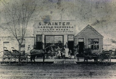
Photograph, Samuel Painter Saddler Shop
... Painter's Saddlery, showing a group of buildings in Main Street, Bacchus Marsh in the later part of the 19th century, post 1883. ...Bacchus Marsh Vic. Small Businesses Bacchus Marsh Fancy Goods George Taylor Bootmakers Samuel Painter On the front: Sign above central building: S.PAINTER. SADDLE HARNESS & COLLAR MAKER. COLLARS CAREFULLY FITTED. On the central window can be seen a sign reading Stationery & Fancy Goods. On the window above the door: Bacchus Marsh Emporium. On the back: Handwritten: Bought by Bowden. Old building on left replaced by W.J.Wilson Hairdresser 1896. Painter Main Street now State Bank. Copy of photograph of S. Painter's Saddlery, showing a group of buildings in Main Street, Bacchus Marsh in the later part of the 19th century ...Samuel Painter, saddler, enlarged George Taylor's premises after buying the building in 1888. He carried on the saddlery while his wife conducted a fancy goods shop. The building on the left was occupied by a bootmaker, Abraham Tracey. The 2025 location for this site is 136 Main Street, Bacchus Marsh. By around 1894 the saddlery and fancy goods business operated by the Painters had ceased. The premises were then used as a greengrocery and confectionery business for some years until this business ceased and the site became the location of a branch of the State Savings Bank of Victoria for many years. Copy of photograph of S. Painter's Saddlery, showing a group of buildings in Main Street, Bacchus Marsh in the later part of the 19th century, post 1883. On the left can be seen part of a building which bears the sign A. Tracey. The middle building carries a large sign advertising the proprietor and his business. It has a large double window, flanked on either side with a doorway. A variety of goods can be seen in the window. On the right is a weatherboard building also set up as a shop. At the front of this complex can be seen two men both wearing work aprons and three children standing on the footpath. Two buggies are pulled up in front of the complex, one four-wheeled, one two wheeled, the smaller vehicle pulled by a pony. The deep gutter is bridged by boards giving access to the unmade road. On the front: Sign above central building: S.PAINTER. SADDLE HARNESS & COLLAR MAKER. COLLARS CAREFULLY FITTED. On the central window can be seen a sign reading Stationery & Fancy Goods. On the window above the door: Bacchus Marsh Emporium. On the back: Handwritten: Bought by Bowden. Old building on left replaced by W.J.Wilson Hairdresser 1896. Painter Main Street now State Bank.saddlery, shops bacchus marsh vic., small businesses bacchus marsh, fancy goods, george taylor, bootmakers, samuel painter
