Showing 48 items matching "background to port fairy"
-
 Federation University Historical Collection
Book, Toni Woolley et al, Port Fairy Community and Organisational Plan, 1999
... port fairy...toni woolley...tamara lang...janelle gilbert...ben balshaw...grant caromody...executive summary...introduction...background...Port Fairy Community and Organisational Plan. University of Ballarat Students' Project. port fairy toni woolley tamara lang janelle gilbert ben balshaw grant caromody executive summary introduction background to port fairy methodology limitations appraisal of tourism planning and development to date assessment of local community issues, attitudes and involvement in tourism roles of local and regional tourism associations effectiveness of local & regional tourism associations analysis of services and service quality moyne shire council friends of port fairy tourism victoria country victoria tourism great ocean road marketing shipwreck coast tourism port fairy tourism association inc moyne shire department of natural resources and environment the western coastal board tourism accreditation board of victoria george borg craig delahoy michael hearn jodie honan judith kershaw andrea lowenthal neil martin john ploenges james purcell peter strickland mark thompson libby wilson michael pearlman battle of the moyne tourism planning great ocean road White bound book of 35 pages plus 6 appendices. ...Port Fairy Community and Organisational Plan. University of Ballarat Students' Project.White bound book of 35 pages plus 6 appendices.port fairy, toni woolley, tamara lang, janelle gilbert, ben balshaw, grant caromody, executive summary, introduction, background to port fairy, methodology, limitations, appraisal of tourism planning and development to date, assessment of local community issues, attitudes and involvement in tourism, roles of local and regional tourism associations, effectiveness of local & regional tourism associations, analysis of services and service quality, moyne shire council, friends of port fairy, tourism victoria, country victoria tourism, great ocean road marketing, shipwreck coast tourism, port fairy tourism association inc, moyne shire, department of natural resources and environment, the western coastal board, tourism accreditation board of victoria, george borg, craig delahoy, michael hearn, jodie honan, judith kershaw, andrea lowenthal, neil martin, john ploenges, james purcell, peter strickland, mark thompson, libby wilson, michael pearlman, battle of the moyne, tourism planning, great ocean road -
 Port Fairy Historical Society Museum and Archives
Photograph
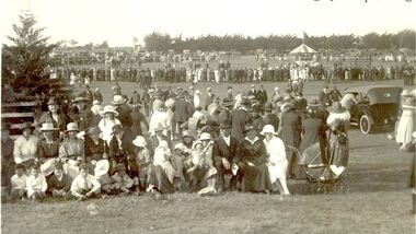
... Black and white photograph of Crowds of people with cars and tent in background at Port Fairy Show Day...Port Fairy Historical Society Museum and Archives 30 Gipps Street Port Fairy great-ocean-road Port Fairy Show Day unsure of date as yet events civil crowd agricultural show pastoral horticutural ap&h Black and white photograph of Crowds of people with cars and tent in background at Port Fairy Show Day Photograph Photograph ...Port Fairy Show Day unsure of date as yet Black and white photograph of Crowds of people with cars and tent in background at Port Fairy Show Dayevents, civil, crowd, agricultural, show, pastoral, horticutural, ap&h -
 Warrnambool and District Historical Society Inc.
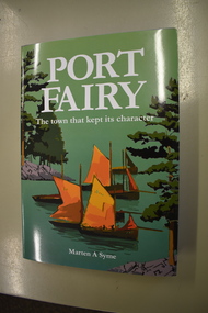
Book, Port Fairy – The Town That Kept Its Character, 2018
... Port Fairy. This book is of considerable significance as it is a comprehensive history of Port Fairy and complements and adds to the earlier histories of this town. It will be a very useful addition to libraries and will be a great aid to family history and local history researchers. Port Fairy Marten Syme, Port Fairy Signature of author (Marten A. Syme) This is a hard cover book of 295 pages. The cover is grey with gold lettering on the spine. The dust cover has white printing and an illustration with a green background ...This book by Marten Syme is a history of Port Fairy from 1835 to 2018. The earlier histories of Port Fairy do not cover most of the 20th century and none of the 21st century. This book is a scholarly work and offers fresh perspectives on many aspects of Port Fairy history and questions some long-held views, especially on the early years of the town. Port Fairy, 293 kilometres west of Melbourne, has a rich history and is one of the earliest places in Victoria to be settled by Europeans. The author Marten Syme has written extensively on both maritime and local history and is a resident of Port Fairy. This book is of considerable significance as it is a comprehensive history of Port Fairy and complements and adds to the earlier histories of this town. It will be a very useful addition to libraries and will be a great aid to family history and local history researchers.This is a hard cover book of 295 pages. The cover is grey with gold lettering on the spine. The dust cover has white printing and an illustration with a green background with a multi-colour design of sailing ships, trees and harbour entrance. The pages of printed material are in five parts with a bibliography and an index. The book has black and white photographs, maps and other illustrative material. Signature of author (Marten A. Syme)port fairy, marten syme, port fairy -
 Warrnambool and District Historical Society Inc.
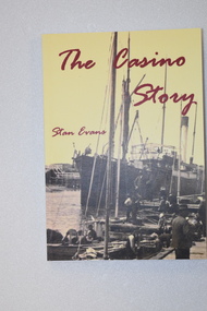
Book - book & bookmark, The Casino Story, 1882
... Port Fairy, Melbourne and other coastal ports including Warrnambool. It was wrecked at Apollo Bay in 1932 with the loss of 10 crew. This book and book mark are of considerable interest as they give details of the 'Casino', a ship that was loved by the people in the coastal towns of Port Fairy and Warrnambool as it served these communities for nearly 50 years. The ship 'Casino' Warrnambool shipping history History of the ship, 'Casino' .1 This is a book of 145 pages.The cover has a yellow background ...History of the ship, 'Casino'.1 This is a book of 145 pages.The cover has a yellow background with an image of a ship and dark red printing. The back cover and spine have red and black printing. The pages contain black and white photographs and sketches and printed material. .2 This is a bookmark with two colour images and printed material on one side and one image and printed material on the other side.non-fictionHistory of the ship, 'Casino'the ship 'casino', warrnambool shipping history -
 Warrnambool and District Historical Society Inc.
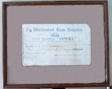
Document - Receipt: Warrnambool Steam Navigation Company
... This is a receipt for a passenger's ticket to travel to Belfast ( Port Fairy) on the Screw Steamship "Otway" in 1875. It is pasted on a brown background and enclosed in a glass covered brown wooden frame.There is string at the back for hanging the item. ...Warrnambool was an important port at that time and this item is part of our marine history. ship "otway" warrnambool warrnambool steam navigation company The Warrnambool Steam Navigation Company Limited Received from Jas Gilligan Ten Shillings for a steerage passage to Belfast 1875 This is a receipt for a passenger's ticket to travel to Belfast ( Port Fairy) on the Screw Steamship "Otway" in 1875. It is pasted on a brown background and enclosed in a glass covered brown wooden frame.There is string at the back for hanging the item. ...This is a passenger ticket for the Screw Steamship "Otway".It was built in 1872 at Glasgow for the Warrnambool Steam Packet Company. She traded to and from the Western Ports until 1878.when she was sold for the Melbourne West Australian trade. She was broken up at Sydney in 1924. The Warrnambool Steam Packet Company commenced in 1868 and operated on the Western Ports run using the ships "Edina", "Rob Roy", "Otway", " Nelson" and "Julia Percy".In 1878 it became the Western Steam Navigation Company which operated until 1896. There is no information available on the passenger James Gilligan This item which may come from the old Warrnambool Museum is of considerable interest as a rare memento of steam travel to and from the Western Ports in the 19th century. Warrnambool was an important port at that time and this item is part of our marine history. This is a receipt for a passenger's ticket to travel to Belfast ( Port Fairy) on the Screw Steamship "Otway" in 1875. It is pasted on a brown background and enclosed in a glass covered brown wooden frame.There is string at the back for hanging the item. The Warrnambool Steam Navigation Company Limited Received from Jas Gilligan Ten Shillings for a steerage passage to Belfast 1875ship "otway", warrnambool, warrnambool steam navigation company -
 Christ Church Anglican Parish of Warrnambool
Memorial window: William RUTLEDGE, "BY THY CROSS AND PASSION GOOD LORD DELIVER US""
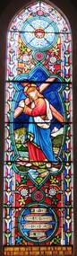
... port fairy christ church warrnambool In Latin: In Memoriam Gulielmi Rutledge qui A.D. MDCCCVI underimo ante Kal: Feb: natus vitam posuit/ Kal: Jun: MDCCCLXXVI Filae amantissimae hanc fenestram pietatis indirio posuerunt Stained glass window, south wall, main nave, depicting Jesus bearing the Cross. The background ...William Rutledge [born 1806, Ireland] was a self-made, larger-than-life man who involved himself prominently in business, municipal, political, community and social aspects of life. Eldest son of James and Martha [nee Forster], William arrived in Australia from Ireland in 1829 and within six years had sufficiently established himself to purchase land in New South Wales. He married Eliza Kirk in Sydney in august 1840. They had two sons and five daughters. In 1843 he began his association and life in Port Fairy and soon became prominent and influential in almost all aspects of that developing town. His interests encompassed mercantile, civic, pastoral, shipping, importing, exporting, immigration, politics and social aspects with in the district and colony. He was a major contributor to the building of St John’s Anglican Church, Port Fairy. He acquired three special surveys with historical importance in Victoria. In south west Victoria that interest being especially the Farnham Survey of 5120 acres between Dennington and Tower Hill/Killarney. This was farmed by immigrant tenant and lessee farmers, some of whom were brought to the Australia at William Rutledge’s own expense and by whom he was considered a kind and considerate landlord. His endeavours were not without failures and in 1862 his Port Fairy Company failed with debts of over £170,000. This debt was redeemed in full within a year. According to reported accounts, William Rutledge had a tempestuous manner with an “explosive” temper, although he did not hold grudges. This is countered by accounts of his kindness, generosity, honesty and practical, progressive outlook in all his undertakings. After the failure and closure of his Company, William Rutledge moved to his property at Farnham Park near Warrnambool where he concentrated his interest in breeding sheep and horses. Throughout his life his home was reputed to be convivial and hospitable. William Rutledge died at Farnham Park on June 1st, 1876. William Rutledge's place in the history of settlement in south west Victoria gives importance to this memorial.Stained glass window, south wall, main nave, depicting Jesus bearing the Cross. The background is quite floral. A medallion shape holds the title as printed on a ribbon: "By thy cross and passion good Lord deliver us".In Latin: In Memoriam Gulielmi Rutledge qui A.D. MDCCCVI underimo ante Kal: Feb: natus vitam posuit/ Kal: Jun: MDCCCLXXVI Filae amantissimae hanc fenestram pietatis indirio posueruntrutledge, william rutledge, farnham survey, port fairy, christ church warrnambool -
 Flagstaff Hill Maritime Museum and Village
Photograph - Historical, Port Fairy, Late 19th to early 20th centuries
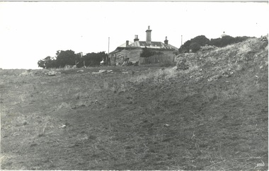
... From research, it has been determined that the cottage was the Port Fairy (Belfast) Lighthouse Keepers cottage. The dome roof in the background indicates a lighthouse, in which case the cottage would have been the living quarters for a lighthouse keeper and assistant keeper. ...Port Fairy (Belfast) Lighthouse Keepers cottage. Near the fenceline on the left, a corrugated water tank is positioned below a pipe joined to the roof gutter. Nearby are a timber shed and timber walls or screens. In the background...Port Fairy (Belfast) Lighthouse Keepers cottage. Near the fenceline on the left, a corrugated water tank is positioned below a pipe joined to the roof gutter. Nearby are a timber shed and timber walls or screens. In the background ...The late 19th to early 20th century stone cottage with weatherboard extensions. From research, it has been determined that the cottage was the Port Fairy (Belfast) Lighthouse Keepers cottage. The dome roof in the background indicates a lighthouse, in which case the cottage would have been the living quarters for a lighthouse keeper and assistant keeper. The narrow poles could have been for signals and antennae. The object on the rock stack looks like a large metal milk can.The photograph shows a typical late 19th to early 20th century cottage, abandoned at dilapidated for many years. Black and white rectangular photograph mounted on card. The image shows a dilapidated stone cottage with an old picket fence. Extending behind the stone cottage are gabled roofs above weatherboard walls. The cottage has corrugated roof sheets of different colours, and four chimneys, three with chimney pots. From research, it has been determined that the cottage was the Port Fairy (Belfast) Lighthouse Keepers cottage. Near the fenceline on the left, a corrugated water tank is positioned below a pipe joined to the roof gutter. Nearby are a timber shed and timber walls or screens. In the background are two tall narrow poles with spheres on top, higher than the cottage, with one pole on each side, the left one attached to the building. A domed roof with a knob on top is on the right behind trees. Several angular shapes appear on the horizon on the left, one almost hidden by the trees. The foreground is rocky and slopes uphill on the right. At the foot of the slope is a stack of closely fitted rocks with an object shaped like a milk can on top and an object to its left that is like an open grid. Handwritten Inscriptions are on the reverse side of the photograph.Pencil on board: " D9 / 200 x 150" Pen on sticker: "52"flagstaff hill maritime museum and village, warrnambool, great ocean road, shipwreck coast, cottage, lighthouse, iron roof, stone building, picket fence, water tank, weatherboard building, 19th century cottage, early 20th century cottage, abandoned cottage, antenna, chimneys, milk can -
 Flagstaff Hill Maritime Museum and Village
Photograph - SS Dawn
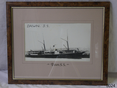
... Port Fairy and became the captain from 1900 until 1922 when he retired after twenty-two years becoming the ships longest-serving captain. Captain Roberts took over command until 1924 followed by captain Middleton until 1932 when the Casino was sunk off Apollo Bay and captain Middleton collapsed and died in the surf. flagstaff hill warrnambool shipwrecked-coast flagstaff-hill flagstaff-hill-maritime-museum maritime-museum shipwreck-coast flagstaff-hill-maritime-village SS Dawn Photograph of SS Dawn at Portland. Building in background ...The SS Dawn steamship was a 522-ton coastal trader built in 1876 and it’s original captain Jones operated the vessel around the Victorian west coast from 1877 until 1898 for the Portland & Belfast Steam Navigation Co, the vessel was then owned in October 1885 by the renamed company, Belfast & Koroit Steam Navigation Co., until March 1896 when it’s ownership moved to W Howard Smith & Sons Ltd., This Melbourne company used the ship to service most ports around Australia. Captain F Chapman took over from captain Jones and served on the SS Dawn from 1898 until 1900 when he took command of the SS Casino operated by the Belfast & Koroit Shipping Company at Port Fairy and became the captain from 1900 until 1922 when he retired after twenty-two years becoming the ships longest-serving captain. Captain Roberts took over command until 1924 followed by captain Middleton until 1932 when the Casino was sunk off Apollo Bay and captain Middleton collapsed and died in the surf. Photograph of SS Dawn at Portland. Building in background Portland and Belfast Steamship CompanySS Dawnflagstaff hill, warrnambool, shipwrecked-coast, flagstaff-hill, flagstaff-hill-maritime-museum, maritime-museum, shipwreck-coast, flagstaff-hill-maritime-village -
 Orbost & District Historical Society
black and white photograph, first half 20th century
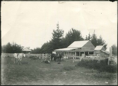
... Port Fairy. He was educated in Scotland and came back to Victoria and selected 320 acres on the Snowy River.The property extended from Majors Creek Road to around about Gilbert's Gulch. This is associated with John Watt, a prominent early settler in Orbost. watt-john-orbost farming-buildings on back - "Watts Farm" A black / white photograph of a dilapidated farm shed with three horses in the foreground. A house can be seen in the background ...Mr John Watt set up farming in 1879. He was a native of Port Fairy. He was educated in Scotland and came back to Victoria and selected 320 acres on the Snowy River.The property extended from Majors Creek Road to around about Gilbert's Gulch.This is associated with John Watt, a prominent early settler in Orbost.A black / white photograph of a dilapidated farm shed with three horses in the foreground. A house can be seen in the background (left) behind a fence. on back - "Watts Farm"watt-john-orbost farming-buildings -
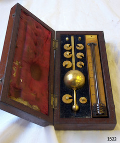 Flagstaff Hill Maritime Museum and Village
Instrument - Hydrometer, J Long (Joseph Long), late 19th - early 20th century
... Flagstaff Hill Warrnambool Shipwrecked coast Flagstaff Hill Maritime Museum Maritime Museum Shipwreck coast Flagstaff Hill Maritime Village Great Ocean Road Measuring instruments Customs tax weighing instrument Sike’s Hydrometer Calibrator Long of London Loftus of London instrument maker Loftus J Long Sikes Hydrometer Scientific Instrument pressure measurement measuring instrument ullage tool Customs Excise Duty Tax alcohol content proof calibrate Standard Weights and Measures tariff Scientific Instrument Makers specific gravity liquid density alcohol testing technology alcohol measurement proof spirit wine and spirits merchants local business brass measuring instrument Port Fairy Customs Office Port Fairy Customs Joseph Long instrument maker All parts of the float and eight weights are inscribed with Serial Number “14674” The float stem is stamped "SIKE'S IID 51o” Calibrator, "LONG LITTLE TOWER ST LONDON" The weights are numbered individually ”20”, “30”, “40”, “50”, “60”, “70”, “80” or “90” Each weight in inscribed; symbol “(J L) [inside an ova, with textured background]” The thermometer inscribed: “LOFTUS OF LONDON” Sikes Hydrometer and thermometer in a fitted wooden case with crimson lining inside the lid and dark lining in the base. ...This Sike’s Hydrometer was donated by the Port Fairy Customs Office as it was no longer required by them due to a change in the law. The hydrometer was part of a system for Ullaging or calculating the amount of liquid remaining in a container of liquor such as a barrel, and the amount of alcoholic content in the contents. It can also measure the free space or head space remaining. Hydrometers were used to measure the density, or relative density, of liquids from the late 1600s. In 1816 Bartholomew Sikes won the competition for the most useful accurate hydrometer. Hydrometers were commonly used by distillers, vintners, and brewers to establish accurate measures of alcohol concentration in their beverages. Following this manufacturing process, government inspectors and excise officers used them to check that the labelled indications of alcohol-proof were correct and that the right amounts of duty were being paid.The Sikes hydrometer is of local significance because of its association with the Government's Customs Office in Port Fairy, in the southwest region of Victoria. It is also associated with Bartholomew Sikes, whose design of a hydrometer was chosen in 1816 as being the most useful and accurate hydrometer. The hydrometer has evolved into the digital version available today to measure density of liquids.Sikes Hydrometer and thermometer in a fitted wooden case with crimson lining inside the lid and dark lining in the base. The case has ten vertical pegs to secure the weights. The brass hydrometer has a spherical float and eight thick brass horseshoe-shaped weights. The serial number is on each section of the float and all weights. Both sides of the float’s upper flat stem have a scale from 0-10, with five divisions between each number. The eight weights are numbered from 20 – 90 in increments of 10. The set includes a mercury thermometer mounted on an ivory back plate labelled with Fahrenheit and Centigrade Scales. The Sikes hydrometer set was made by Loftus of London. The hydrometer model is IID 510, Serial Number is 14674, calibrated by Longs, London. All parts of the float and eight weights are inscribed with Serial Number “14674” The float stem is stamped "SIKE'S IID 51o” Calibrator, "LONG LITTLE TOWER ST LONDON" The weights are numbered individually ”20”, “30”, “40”, “50”, “60”, “70”, “80” or “90” Each weight in inscribed; symbol “(J L) [inside an ova, with textured background]” The thermometer inscribed: “LOFTUS OF LONDON”flagstaff hill, warrnambool, shipwrecked coast, flagstaff hill maritime museum, maritime museum, shipwreck coast, flagstaff hill maritime village, great ocean road, measuring instruments, customs tax, weighing instrument, sike’s hydrometer, calibrator long of london, loftus of london instrument maker, loftus, j long, sikes hydrometer, scientific instrument, pressure measurement, measuring instrument, ullage tool, customs, excise duty, tax, alcohol content, proof, calibrate, standard weights and measures, tariff, scientific instrument makers, specific gravity, liquid density, alcohol testing, technology, alcohol measurement, proof spirit, wine and spirits merchants, local business, brass measuring instrument, port fairy, customs office, port fairy customs, joseph long, instrument maker -
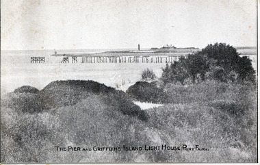 Port Fairy Historical Society Museum and Archives
Postcard, Walker and Lugg, The Pier and Griffith island Lighthouse Port Fairy
... Port Fairy Historical Society Museum and Archives 30 Gipps Street Port Fairy great-ocean-road The Pier and Griffith island Lighthouse Port Fairy pier jetty griffith island red lighthouse keepers cottages The Pier and Griffith Island Lighthouse Port Fairy plus photographic copy of black and white photograph of the remnants of the Campbell Street Pier with the lighthouse and its buildings in the background The Pier and Griffith island Lighthouse Port Fairy Postcard Postcard Walker and Lugg ...The Pier and Griffith island Lighthouse Port Fairyplus photographic copy of black and white photograph of the remnants of the Campbell Street Pier with the lighthouse and its buildings in the backgroundThe Pier and Griffith Island Lighthouse Port Fairypier, jetty, griffith island, red lighthouse, keepers cottages -
 Port Fairy Historical Society Museum and Archives
Photograph
... Port Fairy Historical Society Museum and Archives 30 Gipps Street Port Fairy great-ocean-road East beach near battery hill sails of a tall ship in distance east beach ship ocean sea Coloured photograph of the East Beach with the lighthouse and a tall ship in the background Photograph Photograph ...East beach near battery hill sails of a tall ship in distance Coloured photograph of the East Beach with the lighthouse and a tall ship in the backgroundeast beach, ship, ocean, sea -
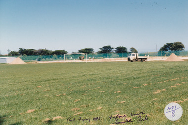 Port Fairy Historical Society Museum and Archives
Photograph, Jock Varcoe
... Port Fairy Historical Society Museum and Archives 30 Gipps Street Port Fairy great-ocean-road Southcombe park october 1985 park botanical paddock field Coloured photograph with workmen and trucks in background Photograph Photograph Jock Varcoe ...Southcombe park october 1985Coloured photograph with workmen and trucks in backgroundpark, botanical, paddock, field -
 Port Fairy Historical Society Museum and Archives
Photograph
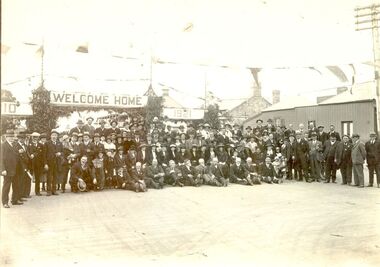
... Port Fairy Historical Society Museum and Archives 30 Gipps Street Port Fairy great-ocean-road Port Fairy Reunion of former residents in 1921 events civil ceremony Reunion Bank Street Black and white photograph of a large group of people posed with road archway in background ‘Welcome Home 1921’ Photograph Photograph ...Port Fairy Reunion of former residents in 1921 Black and white photograph of a large group of people posed with road archway in background ‘Welcome Home 1921’events, civil, ceremony, reunion, bank street -
 Port Fairy Historical Society Museum and Archives
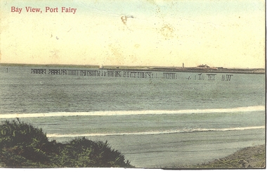
Photograph - Postcard, Bay view
... Port Fairy Historical Society Museum and Archives 30 Gipps Street Port Fairy great-ocean-road beach sea seascape postcard east beach light house keepers house pier Bay View Hand coloured Photograph/postcard of East beach showing ruins of the pier and in the background the lighthouse keeper's residence Bay view Photograph Postcard ...Hand coloured Photograph/postcard of East beach showing ruins of the pier and in the background the lighthouse keeper's residenceBay Viewbeach, sea, seascape, postcard, east beach, light house keepers house, pier -
 Port Fairy Historical Society Museum and Archives
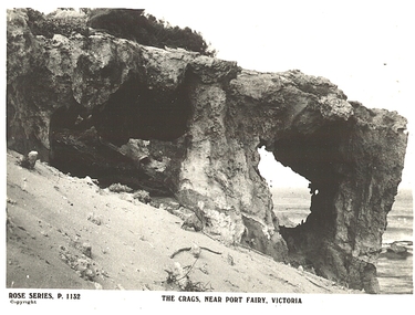
Photograph - Postcard, The Crags near Port Fairy
... Port Fairy Historical Society Museum and Archives 30 Gipps Street Port Fairy great-ocean-road beach sea seascape Rocks The Rose Series p. 1132 The Crags near Port Fairy Victoria Black and white photograph of a rocky outcrop with two large holes through, sandy dune and sea in background The Crags near Port Fairy Photograph Postcard ...Black and white photograph of a rocky outcrop with two large holes through, sandy dune and sea in backgroundThe Rose Series p. 1132 The Crags near Port Fairy Victoriabeach, sea, seascape, rocks -
 Port Fairy Historical Society Museum and Archives
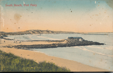
Photograph - Postcard, South beach Bathing boxes
... Port Fairy Historical Society Museum and Archives 30 Gipps Street Port Fairy great-ocean-road South Beach bathing boxes beach sea seascape South Beach Port Fairy Coloured post card of South Beach taken from the West and depicts the bathing boxes in the background South beach Bathing boxes Photograph Postcard ...South Beach bathing boxesColoured post card of South Beach taken from the West and depicts the bathing boxes in the backgroundSouth Beach Port Fairybeach, sea, seascape -
 Port Fairy Historical Society Museum and Archives
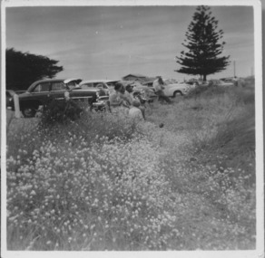
Photograph, East Beach parking 1950-1960s
... Port Fairy Historical Society Museum and Archives 30 Gipps Street Port Fairy great-ocean-road East Beach parking 1950-1960s looking North and upwards from the beach track beach sea seascape east beach norfolk island pine Black and white landscape showing cars parked overlooking the East Beach with a Norfolk Island pine in the background East Beach parking 1950-1960s Photograph Photograph ...East Beach parking 1950-1960s looking North and upwards from the beach trackBlack and white landscape showing cars parked overlooking the East Beach with a Norfolk Island pine in the backgroundbeach, sea, seascape, east beach, norfolk island pine -
 Port Fairy Historical Society Museum and Archives
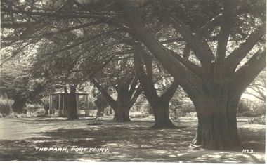
Postcard, "The Park", Port Fairy
... After some months of debate, in which the Councillors suggested that the Engineer had used the money inappropriately, and to which he responded that the build had cost more than the quote, the matter seems to have ended there botanical garden trees rotunda path The Park Port Fairy - No 3 Black and white photograph of the stand of cypress trees with the rotunda in the background "The Park", Port Fairy Postcard Postcard ...Funding for the construction of the Rotunda was bequeathed in the Will of local resident Mrs Annie Williams, who was born in Daylesford in 1872 and died in Kew in 1930. Annie’s Will stipulated that the remaining value of her Estate be spent on erecting a Bandstand in the Port Fairy Botanical Gardens dedicated to the memory of her brother Hugh, a stretcher bearer in WW1 and who died in 1921 after being discharged with health issues, her husband Henry, and herself naturally. There is a plaque dedicated to Annie on the Bandstand She requested that the Bandstand be a replica of the one at Daylesford but by 1933 the value of her Estate had diminished to £76.4/8 which was insufficient to cover a similar design and the Borough Councillors felt it would be too extravagant for the Port Fairy Botanical Gardens. Local builder J.J.McLaren’s tender of £71.15/- was accepted and the octagonal concrete pillared construction was completed with the use of sustenance labour the following year. The Bandstand was opened in December, 1934 with a performance by the Port Fairy Band and local residents enjoying the entertainment and a picnic. In 1934 it was reported that there was some fuss in Council because of the whereabouts of the sum of approximately £3/- , being the amount left over from the build. After some months of debate, in which the Councillors suggested that the Engineer had used the money inappropriately, and to which he responded that the build had cost more than the quote, the matter seems to have ended there Black and white photograph of the stand of cypress trees with the rotunda in the backgroundThe Park Port Fairy - No 3botanical, garden, trees, rotunda, path -
 Port Fairy Historical Society Museum and Archives
Photograph
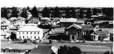
... Port Fairy Historical Society Museum and Archives 30 Gipps Street Port Fairy great-ocean-road Views from St Johns 1973 photo st johns tower james street aerial methodist weslyian braim house Black and white photograph aerial view of Braim House Methodist Church and it's Manse with Sunday school in background Photograph Photograph ...Views from St Johns 1973Black and white photograph aerial view of Braim House Methodist Church and it's Manse with Sunday school in backgroundphoto, st johns, tower, james street, aerial, methodist, weslyian, braim house -
 Port Fairy Historical Society Museum and Archives
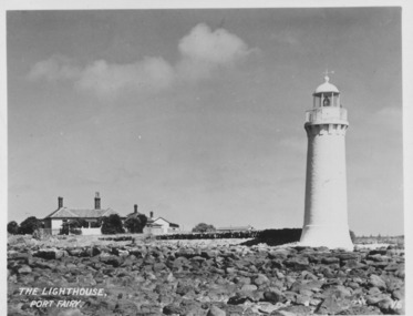
Postcard, The Lighthouse, Port Fairy
... Port Fairy Historical Society Museum and Archives 30 Gipps Street Port Fairy great-ocean-road Picture shows Lighthouse and the Lighthouse Keepers cottage. Hugh Haldane painted the lighthouse white so this photograph was taken after 1929 lighthouse maritime safety Cottage The Lighthouse, Port Fairy- V.6 Black and white photograph of the light house with the lighthouse keepers cottages in the background The Lighthouse, Port Fairy Postcard Postcard ...Picture shows Lighthouse and the Lighthouse Keepers cottage. Hugh Haldane painted the lighthouse white so this photograph was taken after 1929Black and white photograph of the light house with the lighthouse keepers cottages in the backgroundThe Lighthouse, Port Fairy- V.6lighthouse, maritime safety, cottage -
 Port Fairy Historical Society Museum and Archives
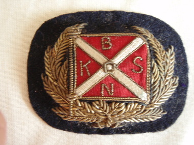
Badge - Hat Badge, Chas. R Martin. Melbourne, 1880-1925
... Port Fairy Historical Society Museum and Archives 30 Gipps Street Port Fairy great-ocean-road Part of Capt. William Robertson's Collection. Spare cap badge of the Belfast and Koroit Steam Navigation Company - S.S.Casino uniform. local history costume male uniform civilian s.s.casino robertson captain or mr william belfast and koroit steam navigation company BKNS Small cap badge: gold emboridered cap badge of laurel leaves around red and cream flag of Belfast and Koroit Steam Navigation Company on Black felt background Badge Hat Badge Chas. ...Part of Capt. William Robertson's Collection. Spare cap badge of the Belfast and Koroit Steam Navigation Company - S.S.Casino uniform.Small cap badge: gold emboridered cap badge of laurel leaves around red and cream flag of Belfast and Koroit Steam Navigation Company on Black felt backgroundBKNSlocal history, costume, male uniform, civilian, s.s.casino, robertson, captain or mr william, belfast and koroit steam navigation company -
 Port Fairy Historical Society Museum and Archives
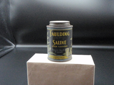
Container - Storage Tin, Fauldings
... Port Fairy Historical Society Museum and Archives 30 Gipps Street Port Fairy great-ocean-road local history domestic items containers Effervescent saline lemon flavoured health salts, 11 ozs nett. A pleasant effervescent beverage. Black background ...Health Salts Storage tin with set in lidEffervescent saline lemon flavoured health salts, 11 ozs nett. A pleasant effervescent beverage. Black background with blue,green and yellow.local history, domestic items, containers -
 Port Fairy Historical Society Museum and Archives
Photograph
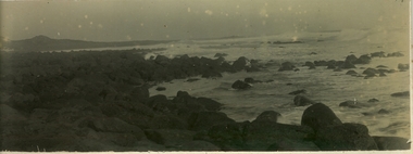
... Port Fairy Historical Society Museum and Archives 30 Gipps Street Port Fairy great-ocean-road beach south beach waves ocean island rocks reef Black and white photograph of the sea looking South East showing the island in the background and a rough sea inbetween Photograph Photograph ...Black and white photograph of the sea looking South East showing the island in the background and a rough sea inbetweenbeach, south beach, waves, ocean, island, rocks, reef -
 Port Fairy Historical Society Museum and Archives
Photograph
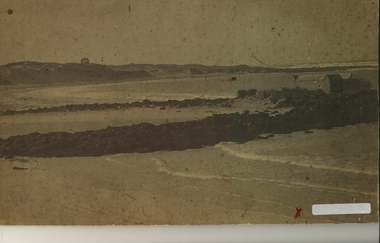
... Port Fairy Historical Society Museum and Archives 30 Gipps Street Port Fairy great-ocean-road Bathing Boxes - South Beach. One of several versions as they were washed away during big storms beach boarding school bay south beach pea soup bathing boxes reefs rocks ocean sea boarding school J.L.Fox Hairdresser and Tobacconist Port fairy Hattams retunour? Black and white photograph of Boarding School Bay looking south east showing bathing boxes on the right and in the background ...Bathing Boxes - South Beach. One of several versions as they were washed away during big stormsBlack and white photograph of Boarding School Bay looking south east showing bathing boxes on the right and in the background what maybe the boarding school on the far hillJ.L.Fox Hairdresser and Tobacconist Port fairy Hattams retunour?beach, boarding school bay, south beach, pea soup, bathing boxes, reefs, rocks, ocean, sea, boarding school -
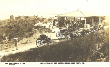 Port Fairy Historical Society Museum and Archives
Postcard, The Rose Series / The Rose Stereographs, The Pavillion at the Bathing Beach Port Fairy Vic
... Port Fairy Historical Society Museum and Archives 30 Gipps Street Port Fairy great-ocean-road Pavilion at South Beach showing horses & buggies beach pavilion South beach bathing boxes kiosk horses buggies people family The Rose Series P.1143. Copyright- The Pavillion at the Bathing Beach Port Fairy Vic. Black and white photograph of the Pavilion at South Beach showing horses & buggies in the middle ground with a group of people in the kiosk and in the background ...Pavilion at South Beach showing horses & buggiesBlack and white photograph of the Pavilion at South Beach showing horses & buggies in the middle ground with a group of people in the kiosk and in the background the bathing boxes and swings taken for use as a postcardThe Rose Series P.1143. Copyright- The Pavillion at the Bathing Beach Port Fairy Vic. beach, pavilion, south beach, bathing boxes, kiosk, horses, buggies, people, family -
 Port Fairy Historical Society Museum and Archives
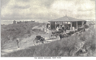
Postcard, The beach pavilion Port Fairy
... Port Fairy Historical Society Museum and Archives 30 Gipps Street Port Fairy great-ocean-road South Beach - showing horses and buggies. beach pavilion south beach kiosk horses buggies bathing boxes The Beach pavilion Port Fairy Black and white photograph of the beach pavillion at the South Beach with horses and buggies in the foreground and the bathing boxes in the background on the left hand side- taken for use as a postcard The beach pavilion Port Fairy Postcard Postcard ...South Beach - showing horses and buggies.Black and white photograph of the beach pavillion at the South Beach with horses and buggies in the foreground and the bathing boxes in the background on the left hand side- taken for use as a postcardThe Beach pavilion Port Fairy beach, pavilion, south beach, kiosk, horses, buggies, bathing boxes -
 Port Fairy Historical Society Museum and Archives
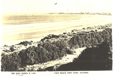
Postcard, The Rose Series / The Rose Stereographs, East Beach, Port Fairy Victoria
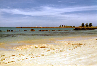
... Port Fairy Historical Society Museum and Archives 30 Gipps Street Port Fairy great-ocean-road east beach Dunes sea ocean griffith island The Rose Series P.1144. Copyright East Beach Port Fairy Victoria Black and white Photograph of East beach looking East South East with dunes in the foreground and the bay and Griffith Island in the background taken for use as a postcard East Beach, Port Fairy Victoria Postcard Postcard The Rose Series / The Rose Stereographs ...Black and white Photograph of East beach looking East South East with dunes in the foreground and the bay and Griffith Island in the background taken for use as a postcardThe Rose Series P.1144. Copyright East Beach Port Fairy Victoriaeast beach, dunes, sea, ocean, griffith island -
 Port Fairy Historical Society Museum and Archives
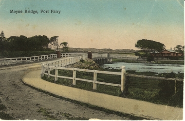
Photograph - Postcard, Moyne Bridge, Port Fairy
... Port Fairy Historical Society Museum and Archives 30 Gipps Street Port Fairy great-ocean-road moyne bridge 1910 river road gipps street Moyne River, Port Fairy Hand tinted photograph of Moyne river road bridge taken looking East showing house on Griffith street on the right side in the background taken for use as a Postcard Moyne Bridge, Port Fairy Photograph Postcard ...Hand tinted photograph of Moyne river road bridge taken looking East showing house on Griffith street on the right side in the background taken for use as a PostcardMoyne River, Port Fairymoyne bridge, 1910, river, road, gipps street -
 Port Fairy Historical Society Museum and Archives
Postcard - post card, A.C. Aberline, Moyne Bridge & River Port Fairy, c.1900
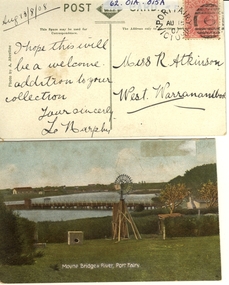
... Port Fairy Historical Society Museum and Archives 30 Gipps Street Port Fairy great-ocean-road A card sent to Miss R. Atkinson of West Warrnambool to add to her collection of postcards moyne bridge moyne river windmill Front:- Moyne bridge & river, port Fairy. Reverse:- aug.13/8/08- i hope this will be a welcome addition to your collection yours Sincerly, L Murphy - To Miss R Atkinson, West Warrnambool Hand coloured Photograph of the Moyne river road bridge, a domestic windmill in foreground and in the background large sheds made for use as a postcard with reverse side stamped Moyne Bridge & River Port Fairy Postcard post card A.C. ...A card sent to Miss R. Atkinson of West Warrnambool to add to her collection of postcardsHand coloured Photograph of the Moyne river road bridge, a domestic windmill in foreground and in the background large sheds made for use as a postcard with reverse side stamped Front:- Moyne bridge & river, port Fairy. Reverse:- aug.13/8/08- i hope this will be a welcome addition to your collection yours Sincerly, L Murphy - To Miss R Atkinson, West Warrnambool moyne bridge, moyne river, windmill