Showing 10852 items matching "baily"
-
 Linton Mechanics Institute and Free Library Collection
Book - Novel, Baily, F. E. (Francis Evans Baily), Enchanted Journey by F.E. Baily, 1934
... Enchanted Journey by F.E. Baily...Baily, F. E. (Francis Evans Baily)...Enchanted Journey by F.E. Baily Book Novel Baily, F. E. (Francis Evans Baily) Collins Clear-Type Press Collins Dispatch Newsagency ...Romance novel.Hardcover book, 252 pages. Book has a red cover. Original dust jacket removed, title and author's name hand printed on spine.fictionRomance novel.f.e. baily, romance, fiction -
 Wodonga & District Historical Society Inc
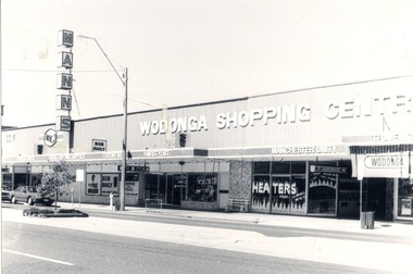
Photograph - Codling Collection 01 - High Street East - Mann's Wodonga Shopping Centre and Bob Baily SSW Supermarket, 1980s
... Codling Collection 01 - High Street East - Mann's Wodonga Shopping Centre and Bob Baily SSW Supermarket...Signs on the edge of the verandah advertise Garden Centre, Rural & Building Supplies, Footwear and a Hairstylist Codling Collection 01 - High Street East - Mann's Wodonga Shopping Centre and Bob Baily SSW Supermarket Photograph Codling Collection 01 - High Street East - Mann's Wodonga Shopping Centre and Bob Baily SSW Supermarket ...Miss Olive Codling was a Foundation Member and a Life Member of the Wodonga Historical Society. Many of her prize-winning photos are held in the Society Collection. She also held a range of roles and committee positions in a wide range of Wodonga community organisations. These included the Horticultural Society, the Wodonga Arts Council, the Wodonga Camera Club and the Wodonga Lapidary Club. This photo collection is significant as it documents how the businesses and buildings in Wodonga have evolved and contributed to community throughout the 20th century.J. Mann and Sons was first established as a farm produce store in 1921. The range of products was extended in the 1930s and included groceries and hardware, as well as the first petrol bowser in Wodonga outside the store. After WWII, the premises were extended and the range of products continued to increase. In the 1960s the Mann Family opened a new supermarket in Wodonga, in addition to the hardware business, providing steel, plumbing and industrial supplies, and employed over 100 people. This site has since been redeveloped and is now the Mann Centre. Signs on the edge of the verandah advertise Garden Centre, Rural & Building Supplies, Footwear and a Hairstylistwodonga businesses, high st wodonga, mann wodonga -
 Surrey Hills Historical Society Collection
Book, William (Willie) Victor Baily Wyatt
... William (Willie) Victor Baily Wyatt...(mr) william (willie) victor baily wyatt soldiers world war, 1914-1918 soldiers - victorian - surrey hills - history A 64 page loose leaf in binder of A4 size. photos William (Willie) Victor Baily Wyatt Book ...William Wyatt was a young soldier, who enlisted in 1915 for World War 1. This is an account of his life during the war until his untimely death at ade 24 in 1917.A 64 page loose leaf in binder of A4 size. photos(mr) william (willie) victor baily wyatt, soldiers, world war, 1914-1918, soldiers - victorian - surrey hills - history -
 Lakes Entrance Historical Society
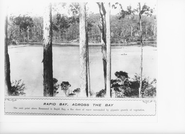
Photograph - Rapid Bay, Lake Tyers Victoria, Caire, Nicholas John, 1905c
... Rapid Bay, across the bay. The next point above Rosamund is Rapid Bay, a fine sheet of water surrounded by gigantic growth of vegetation....Black and white photograph of Rapid Bay, above Rosamund, in Lake Tyers showing two rowing boats on lake, and surrounded by timbered banks. ...Rapid Bay Across the Bay...Lakes Entrance Historical Society 4 Marine Parade Lakes Entrance gippsland Rapid Bay, across the bay. The next point above Rosamund is Rapid Bay, a fine sheet of water surrounded by gigantic growth of vegetation. ...Rapid Bay, across the bay. The next point above Rosamund is Rapid Bay, a fine sheet of water surrounded by gigantic growth of vegetation.Black and white photograph of Rapid Bay, above Rosamund, in Lake Tyers showing two rowing boats on lake, and surrounded by timbered banks. Lake Tyers VictoriaRapid Bay Across the Baywaterways, boats and boating, topography -
 Victorian Interpretive Projects Inc.
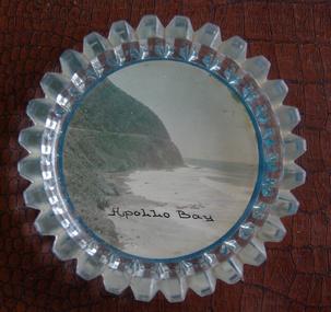
Image of souvenir ware, Apollo Bay
... Apollo Bay...In the 1840s the Henty brothers established a whaling station at Point Bunbury on the western end of the bay. The bay was named by Captain Loutit in 1845 when he sheltered his vessel, the Apollo during a storm. ...The coastline is Cape Patton, Apollo Bay, Victoria..."Apollo Bay"...The coastline is Cape Patton, Apollo Bay, Victoria Apollo Bay Image of souvenir ware ...Apollo Bay is located between Wye River and Cape Otway on Victoria's scenic coastal route, the Great Ocean Road. In the 1840s the Henty brothers established a whaling station at Point Bunbury on the western end of the bay. The bay was named by Captain Loutit in 1845 when he sheltered his vessel, the Apollo during a storm. (http://en.wikipedia.org/wiki/Apollo_Bay)A coloured picture of a coastline attached to a glass butter plate. The coastline is Cape Patton, Apollo Bay, Victoria"Apollo Bay"apollo bay, beach, coast, souvenir -
 Emerald Museum & Nobelius Heritage Park
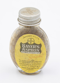
Container - Small Bottle Bayer Aspirin, Bayer Pharma Pty Lty, circa 1948
... Bayer began conducting operations in Australia in 1925. ...The Metal lid has the Bayer Company logo on the top (BAYER written vertically intersecting with BAYER written horizontally). ...On Cap: "BAYER" Company Logo (BAYER written vertically intersecting with BAYER written horizontally) Front Label: "Compressed in N.S.W. / BAYER Company Logo (BAYER written vertically intersecting with BAYER written horizontally) / BAYER'S / ASPIRIN / 24 tablets of 5 grains each / Genuine / The trade-mark 'BAYER Logo (BAYER written vertically intersecting with BAYER written horizontally)' indicates / the 'ASPIRIN' of the Bayer / manufacture of monoacetic- / acidester of salicylicacid / Bayer Pharma Pty. ...This in combination with items from other years and geographic areas can demonstrate the evolution of household medicine. 20th Century Medical & Health On Cap: "BAYER" Company Logo (BAYER written vertically intersecting with BAYER written horizontally) Front Label: "Compressed in N.S.W. / BAYER Company Logo (BAYER written vertically intersecting with BAYER written horizontally) / BAYER'S / ASPIRIN / 24 tablets of 5 grains each / Genuine / The trade-mark 'BAYER Logo (BAYER written vertically intersecting with BAYER written horizontally)' indicates / the 'ASPIRIN' of the Bayer / manufacture of monoacetic- / acidester of salicylicacid / Bayer Pharma Pty. ...Bayer began conducting operations in Australia in 1925. This bottle does not have an exact date of production but it is consistent with bottles produced in Sydney in the late 1940s. The item has historical significance as it is a demonstration of a common household medicine during the 1940s. This in combination with items from other years and geographic areas can demonstrate the evolution of household medicine. A small oval transparent glass bottle with a metal twist cap lid. The Metal lid has the Bayer Company logo on the top (BAYER written vertically intersecting with BAYER written horizontally). There is a primarily dirty yellow front label with primarily brownish grey writing with some write writing that reads "BAYER'S ASPIRIN." The word "Genuine" is located just below the white writing in faded red joint-handwriting font. The final letter of "Genuine" loops up into an arrow pointing towards the previous line's text. The back label is the same dirty yellow as the front, with Brownish-Grey text. It has the Bayer Company logo at the top (BAYER written vertically intersecting with BAYER written horizontally), followed by dosage information and two columns of suggested aliments to consume the original contexts. The bottom has a symbol that is presumably the glass bottle manufacturer. The bottle contains some powder residue of unknown origin. On Cap: "BAYER" Company Logo (BAYER written vertically intersecting with BAYER written horizontally) Front Label: "Compressed in N.S.W. / BAYER Company Logo (BAYER written vertically intersecting with BAYER written horizontally) / BAYER'S / ASPIRIN / 24 tablets of 5 grains each / Genuine / The trade-mark 'BAYER Logo (BAYER written vertically intersecting with BAYER written horizontally)' indicates / the 'ASPIRIN' of the Bayer / manufacture of monoacetic- / acidester of salicylicacid / Bayer Pharma Pty. Ltd. / Sydney" Back Label: "BAYER logo (BAYER written vertically intersecting with BAYER written horizontally) / DOSE / 1 to 2 tablets with water / Used on the following / conditions / Headache Rheumatism / Colds Sciatica / Neuralgia Toothache / Lumbago Earache / Relief of Pain in General / FULL DIRECTIONS FOR USE / IN THE ENCLOSED LEAFLET / Bayer Pharma Pty Ltd / Sydney" Bottom: "Symbol (the letter C in a square above the letter M)20th century, medical & health -
Lakes Entrance Historical Society
Photograph - Rapid Bay Lake Tyers Victoria, Caire, Nicholas John, 1905c
... Rapid Bay, Upwards. Looking up the bay we see the arm as it connects with Helen's Bay....Black and white photograph of Rapid Bay at Lake Tyers through the trees, with an Aboriginal man leaning on a sapling. ...Rapid Bay Upwards...Lakes Entrance Historical Society 4 Marine Parade Lakes Entrance gippsland Rapid Bay, Upwards. Looking up the bay we see the arm as it connects with Helen's Bay. ...Rapid Bay, Upwards. Looking up the bay we see the arm as it connects with Helen's Bay.Black and white photograph of Rapid Bay at Lake Tyers through the trees, with an Aboriginal man leaning on a sapling. The lake, with a rowboat anchored in the centre, is circled by thick vegetation. Lake Tyers VictoriaRapid Bay Upwardswaterways, boats and boating, aboriginals -
 Phillip Island and District Historical Society Inc.
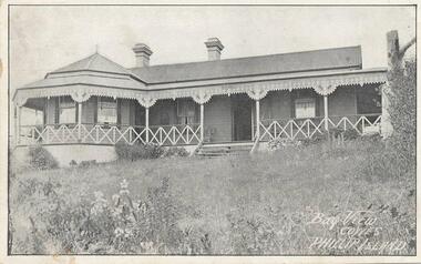
Photograph - Post Card, 17/03/1913
... On back of postcard is an order sent to Mrs Smith of Rhyll from Mrs Eva Richardson of Bay View Cowes, for eating apples and pears. ...Black & White postcard of Bay View Guesthouse...."Bay View Cowes, Phillip Island"...On back of postcard is an order sent to Mrs Smith of Rhyll from Mrs Eva Richardson of Bay View Cowes, for eating apples and pears. bay view cowes phillip island bayview guesthouse cowes mrs richardson mrs smith norma smith "Bay View Cowes, Phillip Island" Black & White postcard of Bay View Guesthouse. ...One of 4 photographs donated by Norma Smith. On back of postcard is an order sent to Mrs Smith of Rhyll from Mrs Eva Richardson of Bay View Cowes, for eating apples and pears. Black & White postcard of Bay View Guesthouse."Bay View Cowes, Phillip Island"bay view cowes phillip island, bayview guesthouse cowes, mrs richardson, mrs smith, norma smith -
 Torquay and District Historical Society
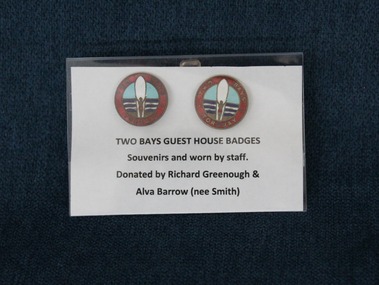
Badge - Badge, guesthouse
... The Two Bays guesthouse badges were souvenirs but were also worn by staff. ...Two badges from the Two Bays guesthouse in Torquay. On the front is painted a beach scene with a surfer and surf board and surrounding it the name of the guesthouse. ...Two Bays Torquay...Guesthouses Two Bays Torquay Two badges from the Two Bays guesthouse in Torquay. ...The Two Bays guesthouse badges were souvenirs but were also worn by staff. The Rice family owned Two Bays Private Hotel, purchased in 1919 when it was a small cottage called "Cooee". It was immediately extended and renamed "Two Bays". Effie Rice ran the guesthouse for 29 years, selling in 1948 to Fred Vairy. Milton and Florence Rowe became the managers and later purchased the business. The next owners were the Williams from c1957 and then John and Wilma Pettigroves until in 1985 Two Bays was sold and demolished for a new apartment complex.Two badges from the Two Bays guesthouse in Torquay. On the front is painted a beach scene with a surfer and surf board and surrounding it the name of the guesthouse. Two Bays Torquayguesthouses -
Lakes Entrance Historical Society
Photograph - Caligurnie Bay Lake Tyers Victoria, Caire, Nicholas John, 1905c
... Caligurnie Bay, outwards. The bay has two reaches and a considerable elevation at the head....Black and white photograph of Caligurnie Bay, Lake Tyers. The picture shows an Aboriginal man sitting on a fallen log in the foreground and a second man sitting in the bow of a rowboat pulled up on the shore. ...Caligurnie Bay Outwards...Waterways Boats and Boating Aboriginals Caligurnie Bay Outwards Black and white photograph of Caligurnie Bay, Lake Tyers. ...Caligurnie Bay, outwards. The bay has two reaches and a considerable elevation at the head.Black and white photograph of Caligurnie Bay, Lake Tyers. The picture shows an Aboriginal man sitting on a fallen log in the foreground and a second man sitting in the bow of a rowboat pulled up on the shore. Lake Tyers VictoriaCaligurnie Bay Outwardswaterways, boats and boating, aboriginals -
 Lakes Entrance Historical Society
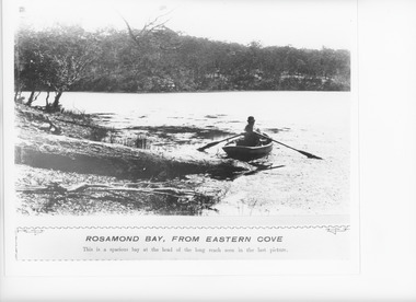
Photograph - Rev John Bulmer Lake Tyers Victoria c1880, Caire, Nicholas John, 1880c
... Rosamond Bay, from eastern cove. This is a spacious bay at the head of the long reach seen in the last picture....Black and white photograph of Rev John Bulmer in rowing boat in the water of Lake Tyers at Rosamond Bay, from eastern cove. Lake Tyers Victoria...Rosamond Bay from Eastern Cove...Lakes Entrance Historical Society 4 Marine Parade Lakes Entrance gippsland Rosamond Bay, from eastern cove. This is a spacious bay at the head of the long reach seen in the last picture. ...Rosamond Bay, from eastern cove. This is a spacious bay at the head of the long reach seen in the last picture.Black and white photograph of Rev John Bulmer in rowing boat in the water of Lake Tyers at Rosamond Bay, from eastern cove. Lake Tyers VictoriaRosamond Bay from Eastern Covewaterways, boats and boating -
 Port Melbourne Historical & Preservation Society
Photograph - Bay Street Plantation strip, c.1963
... In 1963 work was being undertaken to create the central Plantation Strip that divides Bay Street. This section is from The Prince Alfred Hotel to where Bay turns into Crockford Street. ...Photograph looking toward the Fountain Inn with a plantation strip under construction in Bay & Crockford Streets. ...On reverse 'Bay Street Starting the plantation Strip 1963'...Photograph Bay Street Plantation strip ...In 1963 work was being undertaken to create the central Plantation Strip that divides Bay Street. This section is from The Prince Alfred Hotel to where Bay turns into Crockford Street. Photograph possibly taken from the Town Hall tower.Photograph looking toward the Fountain Inn with a plantation strip under construction in Bay & Crockford Streets. On reverse 'Bay Street Starting the plantation Strip 1963'built environment - commercial, fountain inn, bay street, crockford street, prince alfred hotel -
Lakes Entrance Historical Society
Photograph - Rev Bulmer Lake Tyers, Victoria, Caire, Nicholas John, 1880c
... LoTus Bay, with reflections. This picture gives a vivid representation of the general appearance of the lake at morning and eventide....Black and white photograph of Lotus Bay, Lake Tyers showing woman in clinker boat being punted by an Aboriginal. ...Lotus Bay with Reflections...Waterways Aboriginals Lotus Bay with Reflections Black and white photograph of Lotus Bay, Lake Tyers showing woman in clinker boat being punted by an Aboriginal. ...LoTus Bay, with reflections. This picture gives a vivid representation of the general appearance of the lake at morning and eventide.Black and white photograph of Lotus Bay, Lake Tyers showing woman in clinker boat being punted by an Aboriginal. Background of forest which is reflected in lake. Lake Tyers VictoriaLotus Bay with Reflectionswaterways, aboriginals -
 Port Melbourne Historical & Preservation Society
Photograph - Bay Street with Fountain Inn & Quinn's Council Club Hotel, c. 1878
... Brothers John Edward and Edward James CROCKFORD were wine and spirit merchants and publicans and, in 1861, E J CROCKFORD built the Fountain Inn (now the Cornerstone) at the junction of Bay Street & what is now known as Crockford Street.The ground floor dates from 1861 while the top floor was-re-modelled in 1888 to the design of John GRUT. ...Photograph of Bay Street looking towards the Fountain Inn at the intersection of Bay & Crockford Streets....On reverse 'Bay St Quinn's Council Club Hotel Fountain Inn Looking towards Melbourne'...Photograph Bay Street with Fountain Inn & Quinn's Council Club Hotel. ...Brothers John Edward and Edward James CROCKFORD were wine and spirit merchants and publicans and, in 1861, E J CROCKFORD built the Fountain Inn (now the Cornerstone) at the junction of Bay Street & what is now known as Crockford Street.The ground floor dates from 1861 while the top floor was-re-modelled in 1888 to the design of John GRUT. Quinn's Council Club Hotel was built by Michael QUINN in 1874. It closed in 1923.Photograph of Bay Street looking towards the Fountain Inn at the intersection of Bay & Crockford Streets.On reverse 'Bay St Quinn's Council Club Hotel Fountain Inn Looking towards Melbourne'built environment - commercial, business and traders - hotels, fountain inn, john edward crockford, edward james crockford, john grut, quinn's council club hotel -
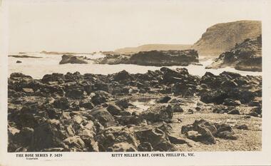 Phillip Island and District Historical Society Inc.
Sepia Photograph, 1920's
... Photo of the rocks at Kitty Millers Bay, Phillip Island...Photograph of the rocks on the shore at Kitty Millers Bay, Phillip Island, at low tide. ...Rose Series P 3429. Kitty Miller's Bay, Cowes, Phillip Is., Vic....Photo of the rocks at Kitty Millers Bay, Phillip Island phillip island kitty millers bay earl of stradbroke Rose Series P 3429. ...This album was presented to the Earl of Stradbroke by the Fathers of Soldiers & Returned Soldiers 16/2/1923. Photo of the rocks at Kitty Millers Bay, Phillip IslandPhotograph of the rocks on the shore at Kitty Millers Bay, Phillip Island, at low tide. Rose Series P 3429. Kitty Miller's Bay, Cowes, Phillip Is., Vic.phillip island, kitty millers bay, earl of stradbroke -
 Port Melbourne Historical & Preservation Society
Photograph - Bay Street looking to the Bay 1963, c.1963
... In 1963 work was being undertaken to create the central Plantation Strip that divides Bay Street. The layout of the strip can be seen although actual work has not begun. ...Photograph looking toward the Bay before the installation of the central Plantation strip. ...On reverse 'Bay Street before plantation strip was started 1963'...Photograph Bay Street looking to the Bay 1963 ...In 1963 work was being undertaken to create the central Plantation Strip that divides Bay Street. The layout of the strip can be seen although actual work has not begun. The photo possibly taken from Port Melbourne Town Hall tower. Note absence of traffic lights.Photograph looking toward the Bay before the installation of the central Plantation strip. On reverse 'Bay Street before plantation strip was started 1963'built environment - commercial, bay street, port melbourne town hall -
 Flagstaff Hill Maritime Museum and Village
Photograph, Mr. H. Pengilley, c. February 1911
... The location of the wreck site was marked for a long time by two anchors on the shoreline, until in 1970 the larger of the two anchors was recovered by the Underwater Explorers' Club and mounted on the foreshore at Apollo Bay. The bell from the wreck was also donated to the Apollo Bay Surf Lifesaving Club but is recorded to have been stolen. ...H. Pengilley Apollo Bay Hotel, Apollo Bay ...H. Pengilley Apollo Bay Hotel, Apollo Bay"...H. Pengilley Apollo Bay Hotel, Apollo Bay Photograph Mr. H. Pengilley ...This photograph would have been taken a while after the SPECULANT was wrecked at Cape Patton, Victoria, because she has broken up and the bow has been moved away from the ship. The barquentine SPECULANT was a steel, three-masted sailing ship built in 1895 in Inverkeithing, Scotland, registered in Warrnambool, Victoria and wrecked at Cape Paton, Victoria, 10th February 1911. The SPECULANT had been involved in the timber trade between the United Kingdom and Russia, until sold to its Warrnambool owners and timber merchants Messrs. P.J. McGennan & Co. (Peter John McGennan) in 1902 for 3000 pounds and had her sailed to Warrnambool as her new port. Peter John McGennan was born in 1844 and worked as a builder and cooper in Holyhead, Anglesea, Wales. He immigrated to Australia in 1869 as a free settler and arrived in Warrnambool in 1871 and undertook management of a property in Grassmere for Mr. Palmer. Peter met his wife Emily in South Melbourne and they married in 1873. They had ten children including Harry who lived to 1965, and Andrew who lived until 1958. (The other children were their four brothers - John who was killed in the Dardenalles aged 35, Frederick who died aged 8, Peter who died aged 28, Frank who died aged 5 weeks - and four sisters - Beatrice who died age 89, Edith who died aged 49, Blanche who died aged 89 and Eveline who died aged 48.) In 1874 Peter starting a boating establishment on the Hopkins River. In 1875 he opened up a Coopers business in Kepler Street next to what was Bateman, Smith and Co., moving to Liebig Street, next to the Victoria Hotel, in 1877. In 1882 he then moved to Lava Street (which in later years was the site of Chandlers Hardware Store). He was associated with the establishment of the Butter Factory at Allansford. He started making Butter Boxes to his own design and cheese batts for the Butter Factory. In 1896 established a Box Factory in Davis Street Merrivale, employing 24 people at its peak, (it was burnt down in 1923); and in Pertobe Road from 1912 (now the Army Barracks building). Peter was a Borough Councillor for Albert Ward from 1885 to 1891, he commenced the Foreshore Trust (including the camping grounds along Pertobe Road), and he was an inaugural Director of the Woollen Mill in Harris Street, buying an extensive share-holding in 1908 from the share trader Edward Vidler. They lobbied the Town Hall to have a formal ‘Cutting’ for the waters of the Merri River to be redirected from its natural opening south of Dennington, to its existing opening near Viaduct Road, in order to have the scourings from the wool at the Woollen Mill discharged into the sea. He sold Butter Boxes around the state, and had to ship them to Melbourne by rail. Peter’s purchase of the SPECULANT in 1902 enabled him to back-load white pine from Kaipara, New Zealand to Warrnambool to make his butter boxes then, to gain profitability, buy and ship potatoes and other primary produce bound to Melbourne. (McGennan & Co. had also owned the LA BELLA, which had traded in timber as well, until she was tragically wrecked with the loss of seven lives, after missing the entrance channel to Warrnambool harbour in 1905. It appears that the SPECULANT was bought to replace the LA BELLA.) In 1911 the SPECULANT had been attempting to depart Warrnambool for almost the entire month of January to undergo docking and overhaul in Melbourne. A month of east and south-easterly winds had forced her to remain sheltered in Lady Bay, Warrnambool apart from one morning of northerlies, when an attempt was made to round Cape Otway; she had to return to shelter in Portland after failing to make any headway. With only 140 tons of sand ballast aboard, the ship would not have been easy to handle. Captain Jacobsen and his crew of nine, mainly Swedes, decided to make for Melbourne, leaving Portland Harbour on 5th February 1911. By the 9th they had reached Cape Otway, where they encountered a moonless night, constant heavy rain, and a heavy sea with a south-easterly wind blowing. After safely rounding Cape Otway the course was changed to east, then north-east to take the vessel to a point six miles off Cape Patton, following the orders of Captain Jacobsen, who told the crew to be very careful with the steering, as the wind and sea was running to leeward. The patent log (used to measure speed) had been out of order for the last four months as no-one in Warrnambool was able to fix it: it was intended to have it repaired in Melbourne. In the meantime the crew measured the vessel's speed by looking over the side and estimating wind strength. This compounded the difficulties of imprecise positioning, as the strong cross wind and sea were acting on the lightly laden vessel to steadily drive it towards the shore. At 3.30am on Friday 10 February 1911 Captain Jacobsen and the first mate were looking over the side of the vessel when they heard the sound of breakers and suddenly struck the rocks. The crew immediately knew they had no chance of getting the SPECULANT off, and attempted to rescue themselves by launching the lifeboat, which was instantly smashed to pieces. One of the crew then volunteered to take a line ashore, and the rest of the crew were all able to drag themselves to shore, some suffering hand lacerations from the rocks. Once ashore they began to walk along the coast towards Lorne, believing it was the nearest settlement. Realising their mistake as dawn broke they returned westwards to Cape Patton, and found a farm belonging to Mr C. Ramsden, who took them in and gave them a change of clothes and food. After resting for a day and returning to the wreck to salvage some of their personal possessions, at 10am on Saturday they set out for Apollo Bay, a voyage that took six hours, sometimes wading through flooded creeks up to their necks. The Age described the wreck as "listed to starboard. All the cabin is gutted and the ballast gone. There is a big rock right through the bottom of her, and there is not the slightest hope of getting her off". A Board of Marine inquiry found that Captain Jacobson was guilty of careless navigation by not taking steps to accurately verify the position of the vessel with respect to Cape Otway when the light was visible and by not setting a safe and proper course with respect to the wind and sea. It suspended his certificate for 6 months and ordered him to pay costs. The location of the wreck site was marked for a long time by two anchors on the shoreline, until in 1970 the larger of the two anchors was recovered by the Underwater Explorers' Club and mounted on the foreshore at Apollo Bay. The bell from the wreck was also donated to the Apollo Bay Surf Lifesaving Club but is recorded to have been stolen. Rusting remains of the wreck can still be found on the shoreline on the southern side of, and directly below Cape Patton. Parts of the SPECULANT site have been buried by rubble from construction and maintenance works to the Great Ocean Road, as well as by naturally occurring landslides. Peter J McGennan passed away in 1920. The Gates in the western wall of the Anglican Church in Henna Street/Koroit St are dedicated to him for his time of community work, which is matched with other prominent Warrnambool citizens; Fletcher Jones, John Younger, J.D.E (Tag) Walter, and Edward Vidler. After Peter J McGennan's death Harry, Andrew and Edith continued to operate the family business until July 11th 1923 when the company was wound up. (Andrew lived in Ryot Street Warrnambool, near Lava Street.) Harry McGennan (Peter and Emily’s son) owned the Criterion Hotel in Kepler Street Warrnambool (now demolished). His son Sid and wife Dot lived in 28 Howard Street (corner of Nelson Street) and Sid managed the Criterion until it was decided by the family to sell, and for he remained Manager for the new owners until he retired. Harry commenced the Foreshore Trust in Warrnambool around 1950. The McGennan Carpark in Pertobe Road is named after Harry and there are Memorial-Stone Gates in his memory. (The Gates were once the original entrance to the carpark but are now the exit.). Peter’s great-grandson, also called Andrew, is a Security Officer in Warrnambool. The Patent Log (also called a Taffrail log) from the SPECULANT, mentioned above, and a number of photographs, are now part of the Collection at Flagstaff Hill Maritime Village. The SPECULANT is historically significant as the largest ship to have been registered in Warrnambool, and is believed to have been the largest barquentine to visit Melbourne. It is evidence of the final days of large commercial sailing vessels involved in the Victorian and New Zealand timber trade. The SPECULANT is listed on the Victorian Heritage Register VHR S626Black and White photograph of the Bow of the Speculant, on rocks at Cape Patton. On reverse side it states that the photograph was taken by Mr. H. Pengilley Apollo Bay Hotel, Apollo Bay "Taken by Mr. H. Pengilley Apollo Bay Hotel, Apollo Bay"flagstaff hill, warrnambool, shipwrecked-coast, flagstaff-hill, flagstaff-hill-maritime-museum, maritime-museum, shipwreck-coast, flagstaff-hill-maritime-village, la bella, speculant, cumming and ellis, international timber trade, p. j. mcgennan and co. warrnambool, peter mcgennan, capt. james jacobsen, warrnambool maritime history, h. pengilley apollo bay, cape patton victoria, warrnambool historical photograph -
Glenelg Shire Council Cultural Collection
Film - Video - Portland Bay Swells, 1983
... "Portland Bay Swells", celebrating Portland's sesquicentenary. ...Video of "Portland Bay Swells" theatrical production celebrating Portland's sesquicentenary....Front: (Reproduction of "Portland Bay Swells" Poster) 1983 - (yellow sticker, l. left). ...Front: (Reproduction of "Portland Bay Swells" Poster) 1983 - (yellow sticker, l. left). ..."Portland Bay Swells", celebrating Portland's sesquicentenary. Devised by Ken Harper and the Portland community. Record of performance at Portland Art Centre.Front: (Reproduction of "Portland Bay Swells" Poster) 1983 - (yellow sticker, l. left). Back: (no inscriptions) -
 Lakes Entrance Historical Society
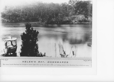
Photograph - Helens Bay Nowa Nowa Arm Lake Tyers Victoria, Caire, Nicholas John, 1905c
... Helen's Bay downwards, eight the steam launch Sunbeam has brought us about eight miles up the arm and we are looking down in the direction from which we came....The Lake View shows smooth water at Helens Bay, Lake Tyers about eight miles upstream in Nowa Nowa Arm, Victoria...Helen's Bay Downwards...The Lake View shows smooth water at Helens Bay, Lake Tyers about eight miles upstream in Nowa Nowa Arm, Victoria Photograph Helens Bay Nowa Nowa Arm Lake Tyers Victoria Caire, Nicholas John ...Helen's Bay downwards, eight the steam launch Sunbeam has brought us about eight miles up the arm and we are looking down in the direction from which we came.Black and white photograph showing a small steam boat with a man on the deck. The Lake View shows smooth water at Helens Bay, Lake Tyers about eight miles upstream in Nowa Nowa Arm, VictoriaHelen's Bay Downwardswaterways, boats and boating -
 Phillip Island and District Historical Society Inc.
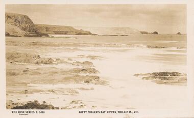
Photograph, 1920's
... Photo of Kitty Millers Bay, Cowes, Phillip Island....Photograph of Kitty Millers Bay showing the headlands and view of Pyramid Rock. ...Rose Series p.3428. Kitty Millers Bay, Cowes, Phillip Island....Photo of Kitty Millers Bay, Cowes, Phillip Island. phillip island kitty millers bay earl of stradbroke Rose Series p.3428. ...This album was presented to the Earl of Stradbroke by Fathers of Soldiers and Returned Soldiers 16/02/1923. Photo of Kitty Millers Bay, Cowes, Phillip Island.Photograph of Kitty Millers Bay showing the headlands and view of Pyramid Rock. Small rocks and surf in foreground.Rose Series p.3428. Kitty Millers Bay, Cowes, Phillip Island.phillip island, kitty millers bay, earl of stradbroke -
 Lakes Entrance Historical Society
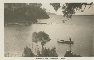
Postcard - Harpers Bay Gippsland Lakes, H D Bulmer, 1925 c
... Harpers Bay showing the jetty where tourist launches moored for passengers to land and walk up to Mrs Westersons Cliffcrest Tea Rooms, Jemmys Point in distance Gippsland Lakes Victoria...Black and white postcard of Harpers Bay showing the jetty where tourist launches moored for passengers to land and walk up to Mrs Westersons Cliffcrest Tea Rooms, Jemmys Point in distance Gippsland Lakes Victoria...Harpers Bay Gippsland Lakes...Lakes Entrance Historical Society 4 Marine Parade Lakes Entrance gippsland Harpers Bay showing the jetty where tourist launches moored for passengers to land and walk up to Mrs Westersons Cliffcrest Tea Rooms, Jemmys Point in distance Gippsland Lakes Victoria Bridges Islands Waterways Gippsland Lakes Harpers Bay Gippsland Lakes Black and white postcard of Harpers Bay showing the jetty where tourist launches moored for passengers to land and walk up to Mrs Westersons Cliffcrest Tea Rooms, Jemmys Point in distance Gippsland Lakes Victoria Postcard Harpers Bay Gippsland Lakes H D Bulmer ...Harpers Bay showing the jetty where tourist launches moored for passengers to land and walk up to Mrs Westersons Cliffcrest Tea Rooms, Jemmys Point in distance Gippsland Lakes VictoriaBlack and white postcard of Harpers Bay showing the jetty where tourist launches moored for passengers to land and walk up to Mrs Westersons Cliffcrest Tea Rooms, Jemmys Point in distance Gippsland Lakes VictoriaHarpers Bay Gippsland Lakesbridges, islands, waterways, gippsland lakes -
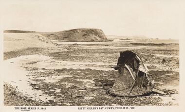 Phillip Island and District Historical Society Inc.
Sepia Photograph, 1920's
... Photo of Kitty Miller Bay, Cowes, Phillip Island, with portion of the Wreck of the Speke - wrecked 2/2/1906...Sepia Photograph of Kitty Miller Bay, Phillip Island, with portion of the Wreck of the Speke - wrecked 2/2/1906...Rose Series P.3442 Kitty Miller's Bay, Cowes, Phillip Is., Vic....Photo of Kitty Miller Bay, Cowes, Phillip Island, with portion of the Wreck of the Speke - wrecked 2/2/1906 Album presented to the Earl of Stradbroke phillip island wreck of the speke earl of stradbroke kitty miller bay Rose Series P.3442 Kitty Miller's Bay, Cowes, Phillip Is., Vic. ...This Album was presented to the Earl of Stradbroke by Fathers of Soldiers and Returned Soldiers 16.2.1995. Photo of Kitty Miller Bay, Cowes, Phillip Island, with portion of the Wreck of the Speke - wrecked 2/2/1906Album presented to the Earl of StradbrokeSepia Photograph of Kitty Miller Bay, Phillip Island, with portion of the Wreck of the Speke - wrecked 2/2/1906Rose Series P.3442 Kitty Miller's Bay, Cowes, Phillip Is., Vic.phillip island, wreck of the speke, earl of stradbroke, kitty miller bay -
 Warrnambool and District Historical Society Inc.
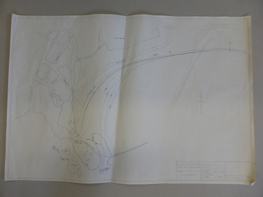
Document - Map, Soil conservation authority:plan of high water marks at Lady Bay Warrnambool, 1984
... Soil conservation authority:plan of high water marks at Lady Bay Warrnambool. ...This map documents the changing state of Lady Bay from around 1870 until 1976. It depicts the changing high water mark over that period and the main outlet of the Merri River in 1872 and 1976....Cream paper map drawn with black ink showing Lady Bay and South Warrnambool section of Warrnambool. ...Written on back in black pencil: Lady Bay Historical HWM ...Written on back in black pencil: Lady Bay Historical HWM Cream paper map drawn with black ink showing Lady Bay and South Warrnambool section of Warrnambool. ...This map documents the changing state of Lady Bay from around 1870 until 1976. It depicts the changing high water mark over that period and the main outlet of the Merri River in 1872 and 1976.This map provides a useful and significant insight into the ever changing face of Lady Bay from the 1870’s through to 1980’s. Cream paper map drawn with black ink showing Lady Bay and South Warrnambool section of Warrnambool. In lower RH corner Soil conservation AuthorityPlan of High water marks at Lady Bay Warrnambool. Drawn P.D. 19.1/84. Scale 1:3600. Written on back in black pencil: Lady Bay Historical HWM lady bay map, merri river 1872- 1976, merri river 1872- 1976, history of warrnambool -
 Warrnambool and District Historical Society Inc.
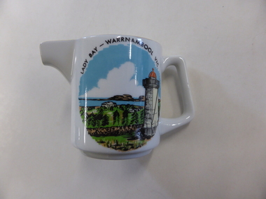
Jug, 'Lady Bay' transfer, 1960s
... 'Lady Bay' transfer...The jug has an image of Lady Bay, Warrnambool. The official name of Lady Bay is Warrnambool Bay. ...On the side of the jug is a multi-coloured image of the lower lighthouse and Lady Bay, Warrnambool. The maker’s name is on the base of the jug. ...‘Lady Bay Warrnambool Vic.’ ‘Fine China Westminster Australia’ ...The jug has an image of Lady Bay, Warrnambool. The official name of Lady Bay is Warrnambool Bay. ...This is a souvenir jug made for the local tourist trade in the 1960s. The jug has an image of Lady Bay, Warrnambool. The official name of Lady Bay is Warrnambool Bay. The jug was made by Westminster Fine China Australia, a firm established in 1954 by the cutlery and silverware firm of Stanley Rogers and Sons of Melbourne. Westminster China was fist established in Cheltenham in Melbourne and after 1977 it was operating in Sandringham, Victoria. It was still operating in the 1990s and produced mainly souvenir and giftware. This jug is retained because it is a good example of the souvenir items offered to local tourists in the 1960s. This is a small white china jug with a gold strip down the handle and a gold rim around the opening and the lip. On the side of the jug is a multi-coloured image of the lower lighthouse and Lady Bay, Warrnambool. The maker’s name is on the base of the jug. ‘Lady Bay Warrnambool Vic.’ ‘Fine China Westminster Australia’ warrnambool bay, westminster china, australia, tourism in warrnambool -
 Flagstaff Hill Maritime Museum and Village
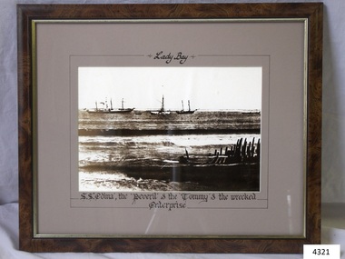
Photograph - Picture, Lady Bay Ships at anchor, after November 1850
... Lady Bay Ships at anchor...The photograph shows sailing ships and a wreck in Lady Bay, Warrnambool. Lady Bay was once a very busy port of trade in Warrnambool and was also called the Port of Warrnambool or Warrnambool Harbour. ...Photograph titled "Lady Bay" depicts Lady Bay, Warrnambool, with vessels including SS Edina, the Peveril and the Tommy, with remains of the 1850 wreck of the schooner Enterprise in foreground. ...Titled, in hand written script, “”Lady Bay”, “S.S. ‘Edina’, the ‘Perevil’ & the ‘Tommy’ & the wrecked "Enterprise” Written in pencil on back “Council”...Lady Bay Ships at anchor Photograph Picture ...The photograph shows sailing ships and a wreck in Lady Bay, Warrnambool. Lady Bay was once a very busy port of trade in Warrnambool and was also called the Port of Warrnambool or Warrnambool Harbour. THE “ENTERPRISE” 1847-1850 The wooden, two-masted schooner Enterprise was built in New Zealand in 1847 and registered in Melbourne, Australia. The Enterprise carried cargos of agricultural produce and other commodities for trade between the ports of the Colony. On September 14, 1850, the Enterprise was at anchor in Lady Bay under its Master, James Gardiner Caughtt, loaded with a cargo of wheat and potatoes. A strong south-easterly wind caused the vessel to drag on its only anchor and the rudder was lost. The gale-force wind blew it sideways and it became grounded. A local indigenous man, Buckawall, braved the rough sea to take a line from the shore to the Enterprise. All five members of the crew were able to make it safely to land. The Enterprise was wrecked. The Enterprise wreck was in an area called Tramway Jetty in Lady Bay. Since then the area became the location of the Lady Bay Hotel and now, in 2019, it is in the grounds of the Deep Blue Apartments. In fact, with the constantly changing coastline through built-up sand, the wreck site is now apparently under the No 2 Caravan Park on Pertobe Road, perhaps 150 metres from the high tide. Its location was found by Ian McKiggan (leader of the various searches in the 1980s for the legendary Mahogany Ship). DIFFERENTIATING the New Zealand Schooner “Enterprise” from John Fawkner’s “Enterprize“ Dr Murray Johns, Melbourne, says in his article The Mahogany Ship Story “… As I documented in 1985, the Warrnambool wreck was of an entirely different ship, also called Enterprize [with the spelling ‘Enterprise’], but built in New Zealand in 1847. Fawkner’s ship had already been sold to Captain Sullivan in 1845 and was wrecked on the Richmond Pier in northern New South Wales early in 1847. “ - (further details are in NOTES: and FHMV documents) This photograph is significant for its association with the screw steamer SS Edina, heritage listed on the Victorian Heritage Database VHR S199. She had endeared herself to the people of Port Phillip Bay as a passenger ferry, part of their own history and culture. She played a significant role in the Crimean War, the American Civil War and the gold rush in New Zealand. She also served western Victoria for many years in her cargo and passenger runs. The SS Edina is famous for being the longest serving screw steamer in the world. After spending her first nine years overseas she arrived in Melbourne and her work included running the essential service of transporting cargo and passengers between Melbourne and the western Victoria ports of Warrnambool, Port Fairy and Portland. The photograph is also significant for its association wreck of the schooner Enterprise, also listed on the Victorian Heritage Listed VHR S238, being a New Zealand built but Australian owned coastal trader. The wreck was also significant for its association with indigenous hero Buckawall who saved the lives of the five crew on board. Photograph titled "Lady Bay" depicts Lady Bay, Warrnambool, with vessels including SS Edina, the Peveril and the Tommy, with remains of the 1850 wreck of the schooner Enterprise in foreground. Titled, in hand written script, “”Lady Bay”, “S.S. ‘Edina’, the ‘Perevil’ & the ‘Tommy’ & the wrecked "Enterprise” Written in pencil on back “Council”flagstaff hill, warrnambool, shipwrecked-coast, flagstaff-hill, flagstaff-hill-maritime-museum, maritime-museum, shipwreck-coast, flagstaff-hill-maritime-village, enterprize, enterprise, port of warrnambool, warrnambool harbour, peveril, tommy, ss edina, pleasure steamer edina, warrnambool steam packet company, david hay, james gardiner caught, tramway jetty, buckawall, lady bay, steam ship, travel, trade, coastal trader, edina, dinah, cargo run, shipping, victoria, port phillip bay, john watson, edward byam, indigenous hero, indigenous rescue -
 Glenelg Shire Council Cultural Collection
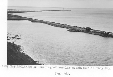
Photograph - Photograph - Lady Bay reclamation, 1960
... Black and white photograph of body of water with man-made breakwater. Lady Bay - reclamation. Dumping of surplus overburden in Lady Bay....Front: Lady Bay Reclamation: Dumping of surplus overburden in Lady Bay/ Jan. 1960 (typed below image, centre) Back: Lady Bay Reclamation: Dumping of/ surplus overburden in Lady Bay (blue pen, centre)...Lady Bay - reclamation. Dumping of surplus overburden in Lady Bay. ...Port of Portland Authority archivesFront: Lady Bay Reclamation: Dumping of surplus overburden in Lady Bay/ Jan. 1960 (typed below image, centre) Back: Lady Bay Reclamation: Dumping of/ surplus overburden in Lady Bay (blue pen, centre)port of portland archives, lady bay, reclamation -
Lakes Entrance Historical Society
Photograph - Sylvia Bay, Lake Tyers Victoria, Caire, Nicholas John, 1905c
... Barook Island from Sylvia Bay.The next point beyond the Rippling Straits is Syvia Bay and from this a view of the island is obtained which shows the steamer's channel to the right and the boat channel to the left, looking down the arm....Black and white photograph showing Barook Island from Sylvia Bay, Lake Tyers. Where a lady is sitting in an anchored rowboat on the shoreline. ...Barook Island from Sylvia Bay...Waterways Boats and Boating Aboriginals Barook Island from Sylvia Bay Black and white photograph showing Barook Island from Sylvia Bay, Lake Tyers. ...Barook Island from Sylvia Bay.The next point beyond the Rippling Straits is Syvia Bay and from this a view of the island is obtained which shows the steamer's channel to the right and the boat channel to the left, looking down the arm.Black and white photograph showing Barook Island from Sylvia Bay, Lake Tyers. Where a lady is sitting in an anchored rowboat on the shoreline. Two Aboriginal men are also shown in the scrub on the shore. Lake Tyers VictoriaBarook Island from Sylvia Baywaterways, boats and boating, aboriginals -
 Lakes Entrance Historical Society
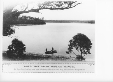
Photograph - Karpi Bay Lake Tyers, Caire, Nicholas John, c1905
... Karpi Bay from Mission Garden. The Nowa Nowa Arm runs to the left of the bathing-house on the other shore, where we find Lake Tyers House....Black and white photograph of Karpi Bay, Lake Tyers showing two men in an open boat in the foreground of a wide expanse of water. ...Karpi Bay from the Lake Tyers Mission garden...Lake Tyers Victoria Photograph Karpi Bay Lake Tyers Caire, Nicholas John ...Karpi Bay from Mission Garden. The Nowa Nowa Arm runs to the left of the bathing-house on the other shore, where we find Lake Tyers House.Black and white photograph of Karpi Bay, Lake Tyers showing two men in an open boat in the foreground of a wide expanse of water. A large tree branch overhanging along the top of the picture, which is taken from a high vantage point. Lake Tyers VictoriaKarpi Bay from the Lake Tyers Mission gardenwaterways, boats and boating, aboriginals -
 Queenscliffe Maritime Museum
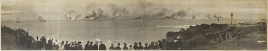
Photograph - One original photograph and one framed and mounted copy of the United States Atlantic Fleet entering Port Phillip Bay in 1908, United States Fleet entering Port Phillip
... On 29 August 1908 Melbourne gaped in wonder as 16 white-hulled battleships of the United States Atlantic Fleet, carrying 14,000 naval personnel, steamed into Port Phillip Bay. The ‘Great White Fleet’ was circumnavigating the globe on a tour launched by President Theodore Roosevelt. ...An original unframed photograph of the United States Altantic Fleet entering Port Phillip Bay in 1908 and a copy framed and mounted under glass....Port Phillip Bay 1908; United States Atlantic Fleet...First visit to Australia by large US Atlantic Fleet in 1908 The Great White Fleet US Atlantic Fleet 1908 Port Phillip Bay Port Phillip Bay 1908; United States Atlantic Fleet An original unframed photograph of the United States Altantic Fleet entering Port Phillip Bay in 1908 and a copy framed and mounted under glass. ...On 29 August 1908 Melbourne gaped in wonder as 16 white-hulled battleships of the United States Atlantic Fleet, carrying 14,000 naval personnel, steamed into Port Phillip Bay. The ‘Great White Fleet’ was circumnavigating the globe on a tour launched by President Theodore Roosevelt. The cruise was a display of naval power and practical exercise, testing the battle-readiness of the US Navy and demonstrating its ability to patrol and protect the west coast and American interests in the Pacific including Australia.An original unframed photograph of the United States Altantic Fleet entering Port Phillip Bay in 1908 and a copy framed and mounted under glass.Port Phillip Bay 1908; United States Atlantic Fleetthe great white fleet, us atlantic fleet, 1908, port phillip bay -
 Phillip Island and District Historical Society Inc.
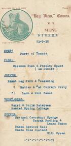
Document, Bayview Dinner Menu, 23/09/1932
... Bay View Guesthouse was located on The Esplanade between Thompson Avenue and Warley Avenue, Cowes, Phillip Island ...Typed menu for dinner on 23/9/1932 at "Bay View", guesthouse, Cowes. Small round photo of a koala on the Menu....Above the koala - Welcome to "Bay View". Below: "I hope you'll enjoy your stay." ...Bay View Guesthouse...Phillip Island and District Historical Society Inc. phillip-island-and-the-bass-coast Bay View Guesthouse was located on The Esplanade between Thompson Avenue and Warley Avenue, Cowes, Phillip Island bay view guest house bay view cowes phillip island guesthouses cowes phillip island j west dinner menu Above the koala - Welcome to "Bay View". ...Bay View Guesthouse was located on The Esplanade between Thompson Avenue and Warley Avenue, Cowes, Phillip Island Typed menu for dinner on 23/9/1932 at "Bay View", guesthouse, Cowes. Small round photo of a koala on the Menu.Above the koala - Welcome to "Bay View". Below: "I hope you'll enjoy your stay." Followed by the menu of Soup: Fish: Joints: Vegetables: Sweets:bay view guest house, bay view cowes phillip island, guesthouses cowes phillip island, j west, dinner menu