Showing 4 items matching "barfold gorge"
-
 Bendigo Historical Society Inc.
Document - PETER ELLIS COLLECTION: INFORMATION ON THE BARFOLD GORGE
... PETER ELLIS COLLECTION: INFORMATION ON THE BARFOLD GORGE......barfold gorge...Foolscap page of information on the Barfold Gorge, by Frank Robbins. Barfold Gorge is compared with the Sydenham Organ Pipes National Park. ...History House 11 Mackenzie Street Bendigo goldfields PLACE Land barfold gorge Peter Ellis Collection Barfold Gorge Sydenham Organ Pipes National Park Campaspe River Mitchell's Falls Queen's Falls Piper's Creek Turpin's Falls Land Conservation Council Victoria Conservation Trust Frank Robbins Foolscap page of information on the Barfold Gorge, by Frank Robbins. ...Foolscap page of information on the Barfold Gorge, by Frank Robbins. Barfold Gorge is compared with the Sydenham Organ Pipes National Park. There is a description of the Gorge. Native vegetation growing there is also mentioned. Turning it into a National Park is mentioned but it is in private ownership and this would require buy back of the land and create access problems as it is a farming area.place, land, barfold gorge, peter ellis collection, barfold gorge, sydenham organ pipes national park, campaspe river, mitchell's falls, queen's falls, piper's creek, turpin's falls, land conservation council, victoria conservation trust, frank robbins -
 Bendigo Historical Society Inc.
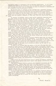
Document - PETER ELLIS COLLECTION: SKETCH OF THE BARFOLD GORGE
... PETER ELLIS COLLECTION: SKETCH OF THE BARFOLD GORGE......barfold gorge...Two hand sketched maps on same sheet of paper, one of the location of the Barfold Gorge in relation to surrounding towns, Mt Alexander and Turpin;s Falls. ...Document PETER ELLIS COLLECTION: SKETCH OF THE BARFOLD GORGE ...Two hand sketched maps on same sheet of paper, one of the location of the Barfold Gorge in relation to surrounding towns, Mt Alexander and Turpin;s Falls. The second map is a part of the Campaspe River location of the Barfold Gorge. Shown is the location of columns, pools, type of rock, Mitchell's Falls, tunnel, cave, Queen's Falls, house, windmill, fences and places where access to the bottom of the gorge is possible. Car track and scale of 1 mile = 6 inches are also shown.place, land, barfold gorge, peter ellis collection, mitchell's falls, queen's falls, turpin's falls -
 Bendigo Historical Society Inc.
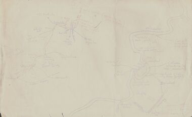
Document - PETER ELLIS COLLECTION: SKETCH OF THE BARFOLD GORGE
... PETER ELLIS COLLECTION: SKETCH OF THE BARFOLD GORGE......barfold gorge...Two photocopies of hand-drawn sketch of the Barfold Gorge. On the sketch is the location of a house, trees, fences, different types of rock, some accessible areas to get down to the river, geological features and water falls....History House 11 Mackenzie Street Bendigo goldfields PLACE Land barfold gorge Peter Ellis Collection Barfold Area Mitchell's Falls Queen's Fall Two photocopies of hand-drawn sketch of the Barfold Gorge. ...Two photocopies of hand-drawn sketch of the Barfold Gorge. On the sketch is the location of a house, trees, fences, different types of rock, some accessible areas to get down to the river, geological features and water falls.place, land, barfold gorge, peter ellis collection, barfold area, mitchell's falls, queen's fall -
 Bendigo Historical Society Inc.
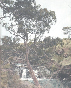
Photograph - WATER FALL - BARFOLD GORGE ?, 1960's ?
... WATER FALL - BARFOLD GORGE ?...Local watercourse - Barfold gorge? F.T. Kennedy printed on bottom right of photo mount....Photograph WATER FALL - BARFOLD GORGE ? ...Hand tinted print: Gorge, with water running over a small waterfall. Large eucalypt centre of print. Local watercourse - Barfold gorge? F.T. Kennedy printed on bottom right of photo mount.F.T. Kennedyplace, landscape view, waterfall