Showing 49 items matching "barker railway station"
-
 Kew Historical Society Inc
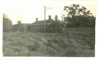
Photograph - The last train at Barker Station, 1952
... ...Barker Railway Station...The Kew railway was opened in 1887, and diverged from the main (Box Hill–Lilydale) line about half-way between Hawthorn and Glenferrie. From the point of divergence the line was slightly less than one mile long, and it had only one intermediate station — Barker. ...Small black and white snapshot of the last passenger train at Barker Railway Station in 1952. The photograph, one of 12, is part of a larger album of newspaper clippings, timetables, tickets and photos relating to the Kew Railway Line, taken and compiled by Lachlan Richardson, while a resident of Kew. ...(Source: Frank Stamford, 'The Hawthorn - Kew Railway') Kew Railway Line Transport -- Railways -- kew (Vic.) Barker Railway Station Kew Branch LIne "Last train at Barker Station / 1 August 1952" Small black and white snapshot of the last passenger train at Barker Railway Station in 1952. ...The Kew railway was opened in 1887, and diverged from the main (Box Hill–Lilydale) line about half-way between Hawthorn and Glenferrie. From the point of divergence the line was slightly less than one mile long, and it had only one intermediate station — Barker. There were four road over-bridges and two level crossings, including one over the busy Barkers Road. The line supported a passenger and goods service, and was electrified in December 1922, at the same time as the main line to Box Hill. There were a number of peak hour services which ran from Flinders Street station (Melbourne) to Kew, but in 1938 all but one of these were diverted to the Ashburton line, where traffic was growing. This had an adverse effect on Kew traffic, as passengers from Kew needed to cross over a footbridge at Hawthorn to change trains, and the main line trains were usually already crowded by the time they reached Hawthorn. At about the same time the off-peak trains were replaced by road buses. In 1952 all passenger trains were withdrawn, but the road bus service continued for many years. Goods trains were finally withdrawn in 1957, and the railway was dismantled in 1958-59. (Source: Frank Stamford, 'The Hawthorn - Kew Railway')Small black and white snapshot of the last passenger train at Barker Railway Station in 1952. The photograph, one of 12, is part of a larger album of newspaper clippings, timetables, tickets and photos relating to the Kew Railway Line, taken and compiled by Lachlan Richardson, while a resident of Kew. The album dates from the 1950s. The album is part of a larger subject file on the Kew Line, compiled over time by members of the Kew Historical Society."Last train at Barker Station / 1 August 1952"kew railway line, transport -- railways -- kew (vic.), barker railway station, kew branch line -
 Kew Historical Society Inc
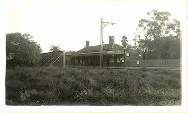
Photograph - Barker Station, August 1952
... ...Barker Railway Station...The Kew railway was opened in 1887, and diverged from the main (Box Hill–Lilydale) line about half-way between Hawthorn and Glenferrie. From the point of divergence the line was slightly less than one mile long, and it had only one intermediate station — Barker. ...Small black and white snapshot of the last passenger train at Barker Railway Station in 1952. The photograph, one of 12, is part of a larger album of newspaper clippings, timetables, tickets and photos relating to the Kew Railway Line, taken and compiled by Lachlan Richardson, while a resident of Kew. ...(Source: Frank Stamford, 'The Hawthorn - Kew Railway') Kew Railway Line Transport -- Railways -- kew (Vic.) Barker Railway Station Kew Branch LIne "Barker Station / August 1952" Small black and white snapshot of the last passenger train at Barker Railway Station in 1952. ...The Kew railway was opened in 1887, and diverged from the main (Box Hill–Lilydale) line about half-way between Hawthorn and Glenferrie. From the point of divergence the line was slightly less than one mile long, and it had only one intermediate station — Barker. There were four road over-bridges and two level crossings, including one over the busy Barkers Road. The line supported a passenger and goods service, and was electrified in December 1922, at the same time as the main line to Box Hill. There were a number of peak hour services which ran from Flinders Street station (Melbourne) to Kew, but in 1938 all but one of these were diverted to the Ashburton line, where traffic was growing. This had an adverse effect on Kew traffic, as passengers from Kew needed to cross over a footbridge at Hawthorn to change trains, and the main line trains were usually already crowded by the time they reached Hawthorn. At about the same time the off-peak trains were replaced by road buses. In 1952 all passenger trains were withdrawn, but the road bus service continued for many years. Goods trains were finally withdrawn in 1957, and the railway was dismantled in 1958-59. (Source: Frank Stamford, 'The Hawthorn - Kew Railway')Small black and white snapshot of the last passenger train at Barker Railway Station in 1952. The photograph, one of 12, is part of a larger album of newspaper clippings, timetables, tickets and photos relating to the Kew Railway Line, taken and compiled by Lachlan Richardson, while a resident of Kew. The album dates from the 1950s. The album is part of a larger subject file on the Kew Line, compiled over time by members of the Kew Historical Society."Barker Station / August 1952"kew railway line, transport -- railways -- kew (vic.), barker railway station, kew branch line -
 Kew Historical Society Inc
Photograph - Seven Carriage Train at Barker Station
... ...Barker Railway Station...The Kew railway was opened in 1887, and diverged from the main (Box Hill–Lilydale) line about half-way between Hawthorn and Glenferrie. From the point of divergence the line was slightly less than one mile long, and it had only one intermediate station — Barker. ...Small black and white snapshot of a seven carriage train approaching Barker Railway Station. The photograph, one of 12, is part of a larger album of newspaper clippings, timetables, tickets and photos relating to the Kew Railway Line, taken and compiled by Lachlan Richardson, while a resident of Kew. ...(Source: Frank Stamford, 'The Hawthorn - Kew Railway') Kew Railway Line Transport -- Railways -- kew (Vic.) Barker Railway Station Kew Branch LIne "Seven Carriage Train at Barker Station" Small black and white snapshot of a seven carriage train approaching Barker Railway Station. ...The Kew railway was opened in 1887, and diverged from the main (Box Hill–Lilydale) line about half-way between Hawthorn and Glenferrie. From the point of divergence the line was slightly less than one mile long, and it had only one intermediate station — Barker. There were four road over-bridges and two level crossings, including one over the busy Barkers Road. The line supported a passenger and goods service, and was electrified in December 1922, at the same time as the main line to Box Hill. There were a number of peak hour services which ran from Flinders Street station (Melbourne) to Kew, but in 1938 all but one of these were diverted to the Ashburton line, where traffic was growing. This had an adverse effect on Kew traffic, as passengers from Kew needed to cross over a footbridge at Hawthorn to change trains, and the main line trains were usually already crowded by the time they reached Hawthorn. At about the same time the off-peak trains were replaced by road buses. In 1952 all passenger trains were withdrawn, but the road bus service continued for many years. Goods trains were finally withdrawn in 1957, and the railway was dismantled in 1958-59. (Source: Frank Stamford, 'The Hawthorn - Kew Railway')Small black and white snapshot of a seven carriage train approaching Barker Railway Station. The photograph, one of 12, is part of a larger album of newspaper clippings, timetables, tickets and photos relating to the Kew Railway Line, taken and compiled by Lachlan Richardson, while a resident of Kew. The album dates from the 1950s. The album is part of a larger subject file on the Kew Line, compiled over time by members of the Kew Historical Society."Seven Carriage Train at Barker Station"kew railway line, transport -- railways -- kew (vic.), barker railway station, kew branch line -
 Kew Historical Society Inc
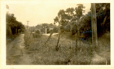
Photograph - Kew Branch Line: Looking along cutting towards Barker Station 22/4/51
... ...Barker Railway Station...The Kew railway was opened in 1887, and diverged from the main (Box Hill–Lilydale) line about half-way between Hawthorn and Glenferrie. From the point of divergence the line was slightly less than one mile long, and it had only one intermediate station — Barker. ...Barker Station 22/4/51. The photograph, one of 12, is part of a larger album of newspaper clippings, timetables, tickets and photos relating to the Kew Railway Line, taken and compiled by Lachlan Richardson, while a resident of Kew. ...(Source: Frank Stamford, 'The Hawthorn - Kew Railway') Kew Railway Line Transport -- Railways -- kew (Vic.) Barker Railway Station Kew Branch LIne "Looking along cutting towards Barker Station 22/4/51" Small black and white snapshot looking along cutting towards Barker Station 22/4/51. ...The Kew railway was opened in 1887, and diverged from the main (Box Hill–Lilydale) line about half-way between Hawthorn and Glenferrie. From the point of divergence the line was slightly less than one mile long, and it had only one intermediate station — Barker. There were four road over-bridges and two level crossings, including one over the busy Barkers Road. The line supported a passenger and goods service, and was electrified in December 1922, at the same time as the main line to Box Hill. There were a number of peak hour services which ran from Flinders Street station (Melbourne) to Kew, but in 1938 all but one of these were diverted to the Ashburton line, where traffic was growing. This had an adverse effect on Kew traffic, as passengers from Kew needed to cross over a footbridge at Hawthorn to change trains, and the main line trains were usually already crowded by the time they reached Hawthorn. At about the same time the off-peak trains were replaced by road buses. In 1952 all passenger trains were withdrawn, but the road bus service continued for many years. Goods trains were finally withdrawn in 1957, and the railway was dismantled in 1958-59. (Source: Frank Stamford, 'The Hawthorn - Kew Railway')Small black and white snapshot looking along cutting towards Barker Station 22/4/51. The photograph, one of 12, is part of a larger album of newspaper clippings, timetables, tickets and photos relating to the Kew Railway Line, taken and compiled by Lachlan Richardson, while a resident of Kew. The album dates from the 1950s. The album is part of a larger subject file on the Kew Line, compiled over time by members of the Kew Historical Society."Looking along cutting towards Barker Station 22/4/51"kew railway line, transport -- railways -- kew (vic.), barker railway station, kew branch line -
 Kew Historical Society Inc
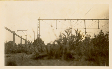
Photograph - Kew Branch Line: Weeds at Kew Station 14/51
... ...Barker Railway Station...The Kew railway was opened in 1887, and diverged from the main (Box Hill–Lilydale) line about half-way between Hawthorn and Glenferrie. From the point of divergence the line was slightly less than one mile long, and it had only one intermediate station — Barker. ...(Source: Frank Stamford, 'The Hawthorn - Kew Railway') Kew Railway Line Transport -- Railways -- kew (Vic.) Barker Railway Station Kew Branch LIne Small black and white snapshot of how the Kew Branch Line was allowed to run down. ...The Kew railway was opened in 1887, and diverged from the main (Box Hill–Lilydale) line about half-way between Hawthorn and Glenferrie. From the point of divergence the line was slightly less than one mile long, and it had only one intermediate station — Barker. There were four road over-bridges and two level crossings, including one over the busy Barkers Road. The line supported a passenger and goods service, and was electrified in December 1922, at the same time as the main line to Box Hill. There were a number of peak hour services which ran from Flinders Street station (Melbourne) to Kew, but in 1938 all but one of these were diverted to the Ashburton line, where traffic was growing. This had an adverse effect on Kew traffic, as passengers from Kew needed to cross over a footbridge at Hawthorn to change trains, and the main line trains were usually already crowded by the time they reached Hawthorn. At about the same time the off-peak trains were replaced by road buses. In 1952 all passenger trains were withdrawn, but the road bus service continued for many years. Goods trains were finally withdrawn in 1957, and the railway was dismantled in 1958-59. (Source: Frank Stamford, 'The Hawthorn - Kew Railway')Small black and white snapshot of how the Kew Branch Line was allowed to run down. The photograph, one of 12, is part of a larger album of newspaper clippings, timetables, tickets and photos relating to the Kew Railway Line, taken and compiled by Lachlan Richardson, while a resident of Kew. The album dates from the 1950s. The album is part of a larger subject file on the Kew Line, compiled over time by members of the Kew Historical Society.kew railway line, transport -- railways -- kew (vic.), barker railway station, kew branch line -
 Kew Historical Society Inc
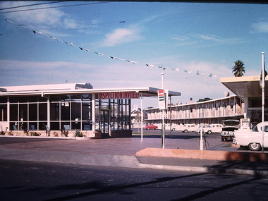
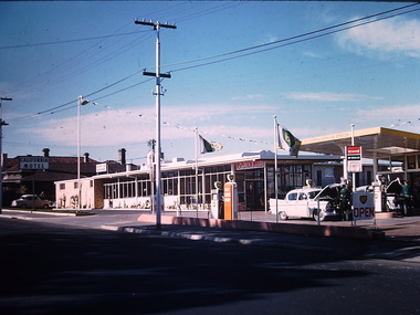
Photograph - California Motel, Barkers Road, Ron Setford, 1961
... Opened in 1960, the California Motel at 138 Barkers Road, Hawthorn, was located opposite the entrance to Xavier College and built on the site of the former Barker railway station of the closed Kew branch line. ..."California Motel" Opened in 1960, the California Motel at 138 Barkers Road, Hawthorn, was located opposite the entrance to Xavier College and built on the site of the former Barker railway station of the closed Kew branch line. ...Ron Setford and his wife Grace Setford lived in Tanner Avenue, East Kew, from c.1946 to c.1995. A keen photographer, he recorded the changing face of Kew over a 20 year period. Apart from 30 photographs of built structures and places in Kew dating from 1960 and 1961, 145 of his 35mm colour slides chronicle the development of the Eastern Freeway through the Yarra Valley over a five year period from c.1972 to c.1977. This important collection was donated to the Society by his granddaughter in 2025.This collection of 175 35mm slides is of local and statewide significance, owing to its subject matter, particularly the major development of road transport infrastructure during the 1970s with the construction of the Eastern Freeway. The photographer also took care to annotate and date most of his slides which enable the researcher to pinpoint temporal and spatial locations.Opened in 1960, the California Motel at 138 Barkers Road, Hawthorn, was located opposite the entrance to Xavier College and built on the site of the former Barker railway station of the closed Kew branch line. The motel was advertised as “away from the hustle and bustle of the city and offering affordable accommodation for the business or leisure traveller”. Special amenities included air-conditioning, a business centre, and swimming pool. The motel had 82 suites. A possibly forgotten, but perhaps essential feature of the motel, was the Caltex Service Station at its entrance. The building was closed in April 2008, extensively vandalised and finally demolished in 2013."California Motel"ron setford, photographs -- kew (vic.) -- 1960s, california motel -- barkers road -- hawthorn (vic.) -
 Kew Historical Society Inc
Photograph - California Motel, Barkers Road, Kew, Ron Setford, 1961
... Opened in 1960, the California Motel at 138 Barkers Road, Hawthorn, was located opposite the entrance to Xavier College and built on the site of the former Barker railway station of the closed Kew branch line. ...California Motel -- Barkers Road Nil Opened in 1960, the California Motel at 138 Barkers Road, Hawthorn, was located opposite the entrance to Xavier College and built on the site of the former Barker railway station of the closed Kew branch line. ...Ron Setford and his wife Grace Setford lived in Tanner Avenue, East Kew, from c.1946 to c.1995. A keen photographer, he recorded the changing face of Kew over a 20 year period. Apart from 30 photographs of built structures and places in Kew dating from 1960 and 1961, 145 of his 35mm colour slides chronicle the development of the Eastern Freeway through the Yarra Valley over a five year period from c.1972 to c.1977. This important collection was donated to the Society by his granddaughter in 2025.This collection of 175 35mm slides is of local and statewide significance, owing to its subject matter, particularly the major development of road transport infrastructure during the 1970s with the construction of the Eastern Freeway. The photographer also took care to annotate and date most of his slides which enable the researcher to pinpoint temporal and spatial locations.Opened in 1960, the California Motel at 138 Barkers Road, Hawthorn, was located opposite the entrance to Xavier College and built on the site of the former Barker railway station of the closed Kew branch line. The motel was advertised as “away from the hustle and bustle of the city and offering affordable accommodation for the business or leisure traveller”. Special amenities included air-conditioning, a business centre, and swimming pool. The motel had 82 suites. A possibly forgotten, but perhaps essential feature of the motel, was the Caltex Service Station at its entrance. The building was closed in April 2008, extensively vandalised and finally demolished in 2013.Nilron setford, photographs -- kew (vic.) -- 1960s, california hotel -- barkers road -- hawthorn (vic.), california motel -- barkers road -
 Kew Historical Society Inc
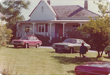
Photograph - 'Neama', Studley Park Road, 1978
... As a young man he was a keen cricketer and played at the first cricket ground in the district, located between Barkers Road and Hawthorn Grove, on the site of the future Barker railway station. Atkyns was admitted to the Victorian Bar in 1861, initially working in his father’s practice. ...As a young man he was a keen cricketer and played at the first cricket ground in the district, located between Barkers Road and Hawthorn Grove, on the site of the future Barker railway station. Atkyns was admitted to the Victorian Bar in 1861, initially working in his father’s practice. ...Edward Augustus Atkyns was born in Wiltshire, England in 1840. His family emigrated to Australia in 1852. As a young man he was a keen cricketer and played at the first cricket ground in the district, located between Barkers Road and Hawthorn Grove, on the site of the future Barker railway station. Atkyns was admitted to the Victorian Bar in 1861, initially working in his father’s practice. He sat as a local magistrate in both Kew and Hawthorn and acted as solicitor for several shire councils. Elected to the Hawthorn Borough Council in 1863 at the age of 23, he served in that municipality as mayor in 1866-67. By 1877, he had moved to Kew where he lived at Neama in Studley Park Road, a property later incorporated into the St Paul’s School for the Blind.Rare colour photograph of what was once a significant house in Kew.Original colour positive photograph (Kodak print) of the main house of 'Neama', colloquially known as the 'farmhouse'. Photographed by Stewart West in April 1978 (it was later demolished by the Villa Maria Society).Annotated reverse: "Front view of Neama / Farmhouse on St Paul's School for the Blind Children / Fernhurst Estate"st paul's school for the blind, neama, studley park road -- kew (vic.), historic houses -- kew (vic.), villa maria society -
 Kew Historical Society Inc
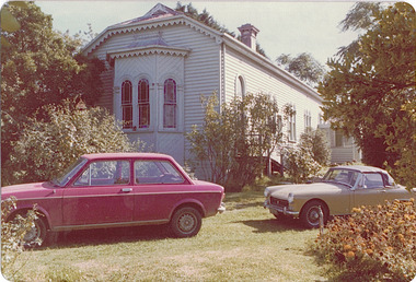
Photograph - 'Neama', Studley Park Road, 1978
... As a young man he was a keen cricketer and played at the first cricket ground in the district, located between Barkers Road and Hawthorn Grove, on the site of the future Barker railway station. Atkyns was admitted to the Victorian Bar in 1861, initially working in his father’s practice. ...As a young man he was a keen cricketer and played at the first cricket ground in the district, located between Barkers Road and Hawthorn Grove, on the site of the future Barker railway station. Atkyns was admitted to the Victorian Bar in 1861, initially working in his father’s practice. ...Edward Augustus Atkyns was born in Wiltshire, England in 1840. His family emigrated to Australia in 1852. As a young man he was a keen cricketer and played at the first cricket ground in the district, located between Barkers Road and Hawthorn Grove, on the site of the future Barker railway station. Atkyns was admitted to the Victorian Bar in 1861, initially working in his father’s practice. He sat as a local magistrate in both Kew and Hawthorn and acted as solicitor for several shire councils. Elected to the Hawthorn Borough Council in 1863 at the age of 23, he served in that municipality as mayor in 1866-67. By 1877, he had moved to Kew where he lived at Neama in Studley Park Road, a property later incorporated into the St Paul’s School for the Blind.Rare colour photograph of what was once a significant house in Kew.Original colour positive photograph (Kodak print) of the secondary building at 'Neama', colloquially known as the 'hall'. Photographed by Stewart West in April 1978 (it was later demolished by the Villa Maria Society).Annotated reverse: "Timber hall on Fernhurst land / Transported there approx 1878."st paul's school for the blind, neama, studley park road -- kew (vic.), historic houses -- kew (vic.), villa maria society -
 Federation University Historical Collection
Photograph, Darling & Co Carriers at Ballarat Railway Station
... Barker Library (top floor) Mount Helen goldfields Ballarat Railway Station Signal box horse teams Victoria House W. ...Offices of Darling and Co Carriers at north side of Ballarat Railway Station with teams of horses and wagons.ballarat railway station, signal box, horse teams, victoria house, w. w. chisham, darling & co general carriers, provincial hotel, chisolm general carrier -
 Federation University Historical Collection
Photograph, Geoff Biddington, Ballarat Railway Station Tower, c1967
... Barker Library (top floor) Mount Helen goldfields Ballarat Railway Station Tower Ballarat Train Station Black and white photograph of the Ballarat Railway Station Tower Ballarat Railway Station Tower Photograph Geoff Biddington ...Black and white photograph of the Ballarat Railway Station Towerballarat railway station tower, ballarat train station -
Federation University Historical Collection
Programme, Ballarat Heritage Weekend - Mothers Day 8-9 May 2010
... Barker Library (top floor) Mount Helen goldfields Federation University has a Campus in Ballarat and therefore Ballarat's Heritage is significant Ballarat Heritage Weekend Judy Verlin The George Hotel Craig's Royal Hotel Old Colonists' Club Sovereign Hill Ballarat Railway Station Sturt Street Her Majesty's Theatre Maps Ballarat Town Hall City of Ballarat Ballarat Mining Exchange Programme outlining events and places of interest for Ballarat Heritage Weekend May 2010 Ballarat Heritage Weekend - Mothers Day 8-9 May 2010 Programme ...Federation University has a Campus in Ballarat and therefore Ballarat's Heritage is significantProgramme outlining events and places of interest for Ballarat Heritage Weekend May 2010ballarat heritage weekend, judy verlin, the george hotel, craig's royal hotel, old colonists' club, sovereign hill, ballarat railway station, sturt street, her majesty's theatre, maps, ballarat town hall, city of ballarat, ballarat mining exchange -
 Federation University Historical Collection
Photograph, Marilyn Jeffs, Hotels of Ballarat, 2019
... Barker Library (top floor) Mount Helen goldfields hotels ballarat royal mail hotel peter lalor hotel the george hotel x on albert hotel cattleyards inn market hotel bunch of grapes hotel argyle hotel atlantic hotel ballarat hotel black hill hotel blue bell hotel bluebell hotel brown hill hotel canberra hotel carboni carboni's italian kitchen eureka stockade hotel carriers arms hotel eastern station hotel centenary hotel craig's hotel eastern railway hotel freight bar athletic club hotel grapes hotel munster arms hotel golden city hotel golf house hotel irish murphy's camp hotel lake view hotel la porchetta southern cross hotel the mallow hotel meaghers hotel millers arms miners tavern hotel miner's tavern hotel provincial hotel north britain hotel north star hotel oscar's hotel criterian hotel park hotel prince regent house prince regent hotel sport globe sporting globe jacksons hotel railway hotel pwtn pater lalor hotel royal highlander hotel queen's head hotel red lion hotel robin hood hotel military arms hotel royal oak hotel western hotel imperial hotel unicorn hotel union hotel Numerous photographs take by Marilyn Jeffs for use on the Ballarat and District Industrial Heritage Wiki Hotels of Ballarat Photograph Marilyn Jeffs ...Numerous photographs take by Marilyn Jeffs for use on the Ballarat and District Industrial Heritage Wikihotels, ballarat, royal mail hotel, peter lalor hotel, the george hotel, x on albert hotel, cattleyards inn, market hotel, bunch of grapes hotel, argyle hotel, atlantic hotel, ballarat hotel, black hill hotel, blue bell hotel, bluebell hotel, brown hill hotel, canberra hotel, carboni, carboni's italian kitchen, eureka stockade hotel, carriers arms hotel, eastern station hotel, centenary hotel, craig's hotel, eastern railway hotel, freight bar, athletic club hotel, grapes hotel, munster arms hotel, golden city hotel, golf house hotel, irish murphy's, camp hotel, lake view hotel, la porchetta, southern cross hotel, the mallow hotel, meaghers hotel, millers arms, miners tavern hotel, miner's tavern hotel, provincial hotel, north britain hotel, north star hotel, oscar's hotel, criterian hotel, park hotel, prince regent house, prince regent hotel, sport globe, sporting globe, jacksons hotel, railway hotel, pwtn, pater lalor hotel, royal highlander hotel, queen's head hotel, red lion hotel, robin hood hotel, military arms hotel, royal oak hotel, western hotel, imperial hotel, unicorn hotel, union hotel -
Federation University Historical Collection
Report, Concept Study for the Development of The Railway Station for the Ballarat Regional Board, c1992, c1992
... Barker Library (top floor) Mount Helen goldfields victorian tourism industry susan lyell sharron smith jennifer steain janene trickey alumni tourism ballarat railway precinct Blue report by four Ballarat University College Students in Tourism. Concept Study for the Development of The Railway Station ...Blue report by four Ballarat University College Students in Tourism. victorian tourism industry, susan lyell, sharron smith, jennifer steain, janene trickey, alumni, tourism, ballarat railway precinct -
 Federation University Historical Collection
Photograph, James (Jim) Smith of Happy Valley
... Barker Library (top floor) Mount Helen goldfields James (Jim) Smith, (died 03/08/1974, aged 93 years) established an orchard growing snow apples near in Happy Valley after returning from mining activities in South Africa. The orchard was called "Springdallah" and was beside the Linton/Happy Valley Road across from the old Happy Valley railway station ...James (Jim) Smith, (died 03/08/1974, aged 93 years) established an orchard growing snow apples near in Happy Valley after returning from mining activities in South Africa. The orchard was called "Springdallah" and was beside the Linton/Happy Valley Road across from the old Happy Valley railway station. Jim was the son of George Henry Smith (18/12/1840 - 26/11/1903) and Emma Keys Smith born Keys (07/08/1842 - 28/08/1888). George and Emma left Liverpool with other unassisted immigrants on the "Bates Family" ship with baby Clara on 08/06/1863 arriving in Melbourne on 08/06/1863. George and Emma emigrated to Australia on the invitation of Emma's brother Edward Keys who owned a property near the school at Happy Valley on which there were two houses. Teddy offered George and Emma the smaller one to live in. When "Teddy" decided to go into hotel keeping George took over the 200 acres of his property and made it a pleasant orchard and garden called "Cress Green Gardens". George had various secretarial jobs - rate collector; paymaster at the mines; until he became Shire Secretary for the Shire of Grenville, whose centre was Linton and Government Auditor for Western Victoria (1894-1903), the means of transport being horse and buggy. Another son followed his father as Shire Secretary. George and Emma had 14 children, Emma dying giving birth to Emma Keys who lived for 16 months. George later married Annie Bolte with 2 more children being born. Annie later sold the property. The land was used for grazing and the two houses fell into disrepair. In 1995 George's grandson Ernest (Alf) Alfred Watson visited the site and reported a wrought iron gate at the site and a mulberry tree near the site of his grandmother's family home. Bluestone blocks can still be seen in the paddocks from the roadside. The child in the photograph is Phyllis Joy Smith, Jim's eldest daughter. Jim Smith was the brother of Clara Emma Yung nee Smith.Sepia photo of two men and a girl. One of them is Jim Smith who established on orchard at Happy Valley. He also went to South Africa - mining activities. The orchard is now part of Clarkesdale Bird Sanctuary located at 360 Linton-Piggoreet Rd, Linton, Vic. 3360. Verso: Jim Smith South Africa (Mining) Established orchard halfway near Linton and Happy Valley. Clara Emma's brother. jim smith, james smith, clara emma smith, happy valley, yendon, piggoreet, south africa, mining, orchard, edward keys, george henry smith, emma keys smith, clara emma yung, annie bolte, shire of grenville, clarkesdale bird sanctury -
 Federation University Historical Collection
Photograph - Photograph - Black and White, Eden Studio, Horne and Watson Families
... Barker Library (top floor) Mount Helen goldfields Hilda Horne (b 06/05/1888 in Yendon) was the 10th child of Thomas William Watson and Emma Eliza Jane Phillips (who was one of the first white children born in the Barrabool Hills area (Geelong). Thomas worked on the Victorian Railways and was stationed ...Hilda Horne (b 06/05/1888 in Yendon) was the 10th child of Thomas William Watson and Emma Eliza Jane Phillips (who was one of the first white children born in the Barrabool Hills area (Geelong). Thomas worked on the Victorian Railways and was stationed at Yendon where they acquired a small farmlet named Graceland. Hilda married George Horne in. They lived in a small cottage in Windermere Street, Ballarat.Three black and white photographs of the Horne family .1 Hilda Horne b Watson 06/05/1888 at Yendon, the daughter of Thomas William and Emma Eliza Jane (b Phillips)Watson. .2 Three Watson sisters - Emma Jacka b Watson 30/08/1866 - 03/04/1904, died in childbirth in South Africa (standing); Hilda Horne b Watson 06/05/1888 (seated L); Eva Watson b 4/06/1890 - 08/07/1959 (seated R) married Leo Wise. .3 George Horne aged 6 months, married Hilda Watson..1 Verso: upper Hilda 1910 Horne; Jack in pencil (her brother John Richard Watson) .2 Verso: upper L - The Yeoman Studios ; C- POST CARD; R - postage stamp outline. CORRESPONDENCE / ADRESS ONLY LHS - handwritten "To Jack with love from Eva"; All Watson sisters; RHS Emma Batt( believe incorrect surname) Eva Watson Hilda Horne .3 Verso: Upper L - Eden Studios; C POST CARD; R - postage stamp outline CORRESPONDENCE / ADDRESS ONLY LHS - EDEN STUDIO Sturt Street Ballarat; handwritten in biro -George Horne; in pencil - Georgie 6 months hilda horne, hilda watson, eva watson, emma jacka, emma watson, eden studio, the yeoman studios, yeoman & co -
 Federation University Historical Collection
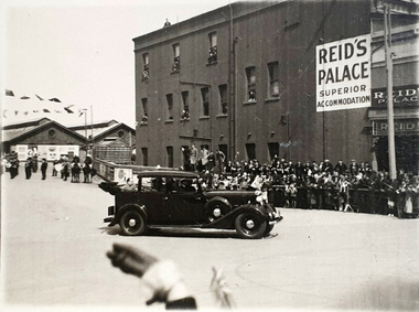
Photograph, Reid's Coffee Palace, Lydiard Street, Ballarat, c1930s ?
... Barker Library (top floor) Mount Helen goldfields The special guest in the car appears to have arrived in Ballarat by train. Could it be William Birdwood to plant trees in the Ballarat Avenue of Honour? There is a band in the background. Note the folded back roof which allows the passenger to be seen by the public. https://architectureau.com/articles/heritage-listed-gold-rush-era-ballarat-coffee-palace-receives-700000-conservation-grant/ reid's coffee palace ballarat railway station ...The special guest in the car appears to have arrived in Ballarat by train. Could it be William Birdwood to plant trees in the Ballarat Avenue of Honour? There is a band in the background. Note the folded back roof which allows the passenger to be seen by the public. https://architectureau.com/articles/heritage-listed-gold-rush-era-ballarat-coffee-palace-receives-700000-conservation-grant/Black and white photos of a car leaving the Ballarat Station (possibly carrying William Birdwood?). Reid's Coffee Palace is in the background Verso - Post (Correspondence)reid's coffee palace, ballarat railway station, visitor, bunting, celebration, ballarat -
Federation University Historical Collection
Booklet, Buninyong Heritage Walks and other Interesting Cycle Rides and Scenic Drives, 2008
... Barker Library (top floor) Mount Helen goldfields buninyong de soza park buninyong tannery buninyong railway station eagle hotel old buninyong library hastie's hill buninyong town hall hastie's spring crown hotel buninyong post office bowen tree aborigines buninyong primary school buninyong cemetery gold monument mount buninyong lal lal falls Blue soft covered book, with maps, plans and photographs relating to Buninyong, Victoria. ...Blue soft covered book, with maps, plans and photographs relating to Buninyong, Victoria. buninyong, de soza park, buninyong tannery, buninyong railway station, eagle hotel, old buninyong library, hastie's hill, buninyong town hall, hastie's spring, crown hotel, buninyong post office, bowen tree, aborigines, buninyong primary school, buninyong cemetery, gold monument, mount buninyong, lal lal falls -
 Federation University Historical Collection
Book - Street Directory, Arnall & Jackson Pty Ltd, Victorian Municipal Directory and Gazatteer, 1939, 1939
... Barker Library (top floor) Mount Helen goldfields A directory of Victorian Municipalities, Comonwealth Guide, and water supply. This is the 74th year of publication. Victorian municipalities municipal councils water supply advertisements Aboriginal Protection Board Agriculture Charities county court crown lands and survey Engine Drivers Board Licensing Court Sludge Abatement Board Cities towns boroughs Ballarat Buninyong Gordon grenville Talbot Traralgon Ballaarat Happy Valley Bungaree Daylesford Glenlyon Glenlyon Shire Hepburn SPrings Beige cover with blue spine. 1052 pages. It includes an index to townships, parishes and Railway stations ...Beige cover with blue spine. 1052 pages. It includes an index to townships, parishes and Railway stations. non-fictionvictorian municipalities, municipal, councils, water supply, advertisements, aboriginal protection board, agriculture, charities, county court, crown lands and survey, engine drivers board, licensing court, sludge abatement board, cities, towns, boroughs, ballarat, buninyong, gordon, grenville, talbot, traralgon, ballaarat, happy valley, bungaree, daylesford, glenlyon, glenlyon shire, hepburn springs -
Federation University Historical Collection
Book - Directory, Arnall & Jackson Pty Ltd, Victorian Municipal Directory and Gazatteer, 1935, 1935
... Barker Library (top floor) Mount Helen goldfields A directory of Victorian Municipalities, Comonwealth Guide, and water supply. This is the 74th year of publication. Victorian municipalities municipal councils water supply advertisements Aboriginal Protection Board Agriculture Charities county court crown lands and survey Engine Drivers Board Licensing Court Sludge Abatement Board Cities towns boroughs Ballarat Buninyong Gordon grenville Talbot Traralgon Ballaarat Happy Valley Bungaree Daylesford Glenlyon Glenlyon Shire Hepburn SPrings Brown cover with maroon spine. 801 pages. It includes an index to townships, parishes and Railway stations ...Brown cover with maroon spine. 801 pages. It includes an index to townships, parishes and Railway stations. non-fictionvictorian municipalities, municipal, councils, water supply, advertisements, aboriginal protection board, agriculture, charities, county court, crown lands and survey, engine drivers board, licensing court, sludge abatement board, cities, towns, boroughs, ballarat, buninyong, gordon, grenville, talbot, traralgon, ballaarat, happy valley, bungaree, daylesford, glenlyon, glenlyon shire, hepburn springs -
Federation University Historical Collection
Book - Directory, Arnall & Jackson Pty Ltd, Victorian Municipal Directory and Gazatteer, 1924, 1924
... Barker Library (top floor) Mount Helen goldfields A directory of Victorian Municipalities, Comonwealth Guide, and water supply. This is the 74th year of publication. Victorian municipalities municipal councils water supply advertisements Aboriginal Protection Board Agriculture Charities county court crown lands and survey Engine Drivers Board Licensing Court Sludge Abatement Board Cities towns boroughs Ballarat Buninyong Gordon grenville Talbot Traralgon Ballaarat Happy Valley Bungaree Daylesford Glenlyon Glenlyon Shire Hepburn SPrings Brown cover with blue spine. 708 pages. It includes an index to townships, parishes and Railway stations ...Brown cover with blue spine. 708 pages. It includes an index to townships, parishes and Railway stations. non-fictionvictorian municipalities, municipal, councils, water supply, advertisements, aboriginal protection board, agriculture, charities, county court, crown lands and survey, engine drivers board, licensing court, sludge abatement board, cities, towns, boroughs, ballarat, buninyong, gordon, grenville, talbot, traralgon, ballaarat, happy valley, bungaree, daylesford, glenlyon, glenlyon shire, hepburn springs -
Federation University Historical Collection
Report, Cultural Landscapes Study of Creswick Goldfields Area for Australian Hertiage Commission
... Barker Library (top floor) Mount Helen goldfields goldfields of victoria goldfields tourism marketing tourism creswick creswick goldfields allendale broomfield rocklyn bullengarook mollongghip dean scrub hill clarkes hill creswick railway station creswick school of forestry sawpit gully oak gully creswick cemetery kingston creswick avenue of honour kerrins bridge berry deep leads mine system australasian mine site creswick alluvial workings calembeen park ascot anderson's mill smeaton hepburn lagoon White bound report with clear cover Cultural Landscapes Study of Creswick Goldfields Area for Australian Hertiage Commission Report Chris McConville Chris Olver ...White bound report with clear covergoldfields of victoria, goldfields tourism, marketing, tourism, creswick, creswick goldfields, allendale, broomfield, rocklyn, bullengarook, mollongghip, dean, scrub hill, clarkes hill, creswick railway station, creswick school of forestry, sawpit gully, oak gully, creswick cemetery, kingston, creswick avenue of honour, kerrins bridge, berry deep leads mine system, australasian mine site, creswick alluvial workings, calembeen park, ascot, anderson's mill, smeaton, hepburn lagoon -
 Federation University Historical Collection
Booklet, Doug Bradby, Lydiard Street: The Goldfields Grandeur of Ballarat, 2021
... Barker Library (top floor) Mount Helen goldfields ballarat lydiard street old colonists' association of ballarat art gallery of ballarat ballarat fine art gallery the george hotel leonard terry. provincial hotel ballarat mining exchange ballarat railway station soldiers hill regent theatre charles lydiard government camp golden fleece hotel Thirty two page green covered book on Ballarat's Lydiard Street, including information on the Old Colonists' Association of Ballarat, Art Gallery of Ballarat, Ballarat Fine Art Gallery, The George Hotel, Leonard terry. ...Thirty two page green covered book on Ballarat's Lydiard Street, including information on the Old Colonists' Association of Ballarat, Art Gallery of Ballarat, Ballarat Fine Art Gallery, The George Hotel, Leonard terry. Provincial Hotel, Ballarat Mining Exchange, Ballarat Railway Station, Soldiers Hill, Regent Theatre.non-fictionballarat, lydiard street, old colonists' association of ballarat, art gallery of ballarat, ballarat fine art gallery, the george hotel, leonard terry. provincial hotel, ballarat mining exchange, ballarat railway station, soldiers hill, regent theatre, charles lydiard, government camp, golden fleece hotel -
Federation University Historical Collection
Book - Book - Scrapbook, Ballarat School of MInes: Scrapbook of Newspaper Cuttings, Book 50, October 1991 to January 1992
... Barker Library (top floor) Mount Helen goldfields Collection of newspaper articles related to Ballarat School Of Mines.They cover activities and advertisements for staff. The papers concerned are The Courier, Ballarat, The Australian, The Age over the period of 16 October 1991 to 31 January 1992. teaching positions advertised pre-employment courses courses available enrolment for smb courses smb automotive department grant and donation smb launches disabled students' policy students' exhibit works at railway station home care supervisors training officers to stay lindy inkstermost promising student smb bids for overseas enrolment vicki louden top of office course self advocacy skills program sandy cook's ceramics on display margarine sculptors in action smb horticulture school minister praises new schools link amcast improves literacy skills ballarat university college buc searching for the past extra 487 smb places jamie heffernan at stepnell's truck depot demand hits tertiary colleges apprenticeships fall peter mansfield librarian Book with yellow cover, front, spiral bound. ...Collection of newspaper articles related to Ballarat School Of Mines.They cover activities and advertisements for staff. The papers concerned are The Courier, Ballarat, The Australian, The Age over the period of 16 October 1991 to 31 January 1992.Book with yellow cover, front, spiral bound. teaching positions advertised, pre-employment courses, courses available, enrolment for smb courses, smb automotive department grant and donation, smb launches disabled students' policy, students' exhibit works at railway station, home care supervisors, training officers to stay, lindy inkstermost promising student, smb bids for overseas enrolment, vicki louden top of office course, self advocacy skills program, sandy cook's ceramics on display, margarine sculptors in action, smb horticulture school, minister praises new schools link, amcast improves literacy skills, ballarat university college, buc, searching for the past, extra 487 smb places, jamie heffernan at stepnell's truck depot, demand hits tertiary colleges, apprenticeships fall, peter mansfield librarian -
Glen Eira Historical Society
Document - KOOYONG ROAD, 75, CAULFIELD NORTH
... Barker L.A. (Lieutenant)... Blair Mrs.... Aylen D.R.... Aylan D.R. Mrs.... Goltz M.H.... Compton E.J. (Brigadier)... Goltz M.H. (Chief Superintendant)... Caulfield John... Wynne Agar... Murphy (Mayor)... Hate P.... Ison (Captain)... Fisher Andrew... Morris T.W. (Mayor)... Caulfield... Kooyong Road... Caulfield Park... North Caulfield... City of Caulfield... City Hall... Balaclava Road... Hawthorn Road... Glen Eira Road... Hartley Avenue... Caulfield Racecourse... Caulfield Town Hall... Alma Road... Orrong Road... Garden Vale... Caulfield Railway Station...Barker L.A. (Lieutenant) Blair Mrs. Aylen D.R. Aylan D.R. Mrs. Goltz M.H. Compton E.J. (Brigadier) Goltz M.H. (Chief Superintendant) Caulfield John Wynne Agar Murphy (Mayor) Hate P. Ison (Captain) Fisher Andrew Morris T.W. (Mayor) Caulfield Kooyong Road Caulfield Park North Caulfield City of Caulfield City Hall Balaclava Road Hawthorn Road Glen Eira Road Hartley Avenue Caulfield Racecourse Caulfield Town Hall Alma Road Orrong Road Garden Vale Caulfield Railway Station Paddy’s Swamp Great Dandenong Road Glen Ferrie Road Dandenong Road East Caulfield Reserve Caulfield Military Hospital ‘Glen Eira’ Town Hall ‘War Office’ Red Chequer Cab Company Caulfield Council Third Ordnance Services Unit Royal Australian Army Ordnance Corps Australian Army Army Headquarters Printing Press Searchlight Company Amenities Store Armoured Replacement Unit First Base Printing Company R.A.A.O.C. ...Three copies of a pamphlet for the ceremony of the Third Ordnance Services Unit ‘Exercising the Right of the Freedom of Entry to the City of Caulfield’, held on 13/07/1986. The pamphlet includes a brief history of the Unit’s association with the City of Caulfield, a list of individuals holding posts within the unit, text of the scroll conferring the Freedom of Entry on the Unit, a program of the ceremony, a brief history of the Royal Australian Army Ordnance Corps, including the Unit’s use of 75 Kooyong Road as their premises, a brief history of the city of Caulfield and an explanation of the tradition of conferring Freedom of Entry to a city. The pamphlet includes also: 1/A black and white photograph (61x66mm) of the Mayor of Caulfield, Maxwell Blair, undated and unattributed. 2/A black and white photograph (70x51mm) of Major P.G. Hateley, Commanding Officer of the Third Ordnance Services Unit, undated and unattributed. 3/A black and white photograph (91x90mm) of the Sovereign’s Banner, undated and unattributed. 4/A black and white copy (137-87) of the scroll conferring Freedom of Entry into the City of Caulfield which was seated August 4 1978. 5/A color illustration (30x32mm) of the City of Caulfield Coat of Arms. 6/A colour illustration (40x32mm) of the Third Ordnance Services Unit, Royal Australian Army Ordnance Corps Coat of Arms. 7/A black and white illustration (21x24mm) of the City of Caulfield Coat of Arms. 8/A black and white illustration (19x19mm) of the City of Caulfield badge. 9/A black and white illustration (22x31mm) of the City of Caulfield banner.blair maxwell (mayor), hateley p.g. (major), finning d.j. (captain), lowe g. (captain), barker l.a. (lieutenant), blair mrs., aylen d.r., aylan d.r. mrs., goltz m.h., compton e.j. (brigadier), goltz m.h. (chief superintendant), caulfield john, wynne agar, murphy (mayor), hate p., ison (captain), fisher andrew, morris t.w. (mayor), caulfield, kooyong road, caulfield park, north caulfield, city of caulfield, city hall, balaclava road, hawthorn road, glen eira road, hartley avenue, caulfield racecourse, caulfield town hall, alma road, orrong road, garden vale, caulfield railway station, paddy’s swamp, great dandenong road, glen ferrie road, dandenong road, east caulfield reserve, caulfield military hospital, ‘glen eira’, town hall, ‘war office’, red chequer cab company, caulfield council, third ordnance services unit royal australian army ordnance corps, australian army, army headquarters printing press, searchlight company, amenities store, armoured replacement unit, first base printing company r.a.a.o.c., caulfield district road board, shire of caulfield, caulfield recruiting committee for volunteers, city repatriation committee, red cross emergency service, women’s national service, mayor’s patriotic fund, promotions committee for war savings certificates, war savings group scheme, ‘the gazette’, air raid precautions committee, armed forces, world war 1939-1945, local government, parades and processions, military reserves, world war 1914-1918, councillors, events and activities, historic events, official events -
Bendigo Historical Society Inc.
Map - HARCOURT, December 1951
... Station, Barkers Creek, Faraday, Calder Highway, Northern Railway. By Authority J.J.Gourley, Government Printer, Melbourne,Drawn and Reproduced at the Dept. of Lands and Survey, Melbourne, Victoria. ...Station, Barkers Creek, Faraday, Calder Highway, Northern Railway. By Authority J.J.Gourley, Government Printer, Melbourne,Drawn and Reproduced at the Dept. of Lands and Survey, Melbourne, Victoria. ...Harcourt, County of Bendigo, Walmer, Castlemaine, Sutton Grange. Mt.Alexander Trig. Station, Barkers Creek, Faraday, Calder Highway, Northern Railway. By Authority J.J.Gourley, Government Printer, Melbourne,Drawn and Reproduced at the Dept. of Lands and Survey, Melbourne, Victoria. December 1951. Price 5/-per sheet. (number 35 in map cupboard 1)J.J.Gourley, Government Printer, Melbourne.map, bendigo, harcourt -
 Federation University Historical Collection
Book, Sovereign City: A Ballarat Tapestry, 1974
... Barker Library (top floor) Mount Helen goldfields ballarat buildings architecture edward heffernan Inside front cover 'E. Lee Hamilton' Hard covered book of 80 pages with a yellow dust jacket. Many sketches including Armstrong Street, Lydiard Street, Montrose Cottage Eureka Street, Lauderdale, Ballarat Railway Station. ...Hard covered book of 80 pages with a yellow dust jacket. Many sketches including Armstrong Street, Lydiard Street, Montrose Cottage Eureka Street, Lauderdale, Ballarat Railway Station. Bailey's Mansion, Former Ballarat Gaol, Ballarat Town Hall, Camp Street Police Station. Ballarat East Post Office, Ballarat Synagogue, Lal Lal blast furnace, Sovereign Hill, Mount Buninyong, Dana Street Primary School. non-fictionballarat, buildings, architecture, edward heffernan -
 Federation University Historical Collection
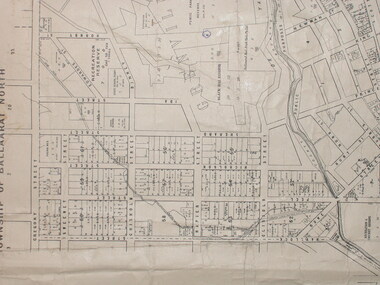
Plan, City of Ballarat (Part) (Ballaarat East), 08/05/1928
... Barker Library (top floor) Mount Helen goldfields map plan ballarat east ballarat woollen mill ballarat railway line ballarat railway station eureka reserve eureka cemetery ballarat orphanage russell square bakery hill Crown Cadastral Plan showing Governement Roads, Crown Parcels, Dimensions, Crown grantees, dated of grants, etc in Ballarat East. ...Crown Cadastral Plan showing Governement Roads, Crown Parcels, Dimensions, Crown grantees, dated of grants, etc in Ballarat East. The plan shows features such as Bakery Hill, Canadian Station, recreation reserves, timber reserves, Yarrowee Creek, Black Hill Reserve, Eureka Reserve and Garden, Orphan Asylum, Rifle Butts Reserve, Ballarat Woollen Mill, Ballarat Observatory, Sovereign Hill Recreation Reserve, Specimen Vale, Market Reserve, Cemetery WGS 84 Centroid 37 degrees 33' 55" S 143 degrees 52' 38" E E.W. Extent; 5 km N-S Extent; 4 kmmap, plan, ballarat east, ballarat woollen mill, ballarat railway line, ballarat railway station, eureka reserve, eureka cemetery, ballarat orphanage, russell square, bakery hill -
 Federation University Historical Collection
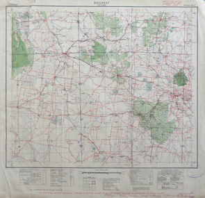
Map, Ballarat, Victoria, 1942, 1942
... Barker Library (top floor) Mount Helen goldfields ballarat map world war two skipton creswick ararat lake bolac Printed in red at the base of the map "This map is an official document. If found, itmust be handed in to the nearest Military Headquarters or Police Station. Two copies of a map of the district around Ballarat, including Creswick, Scarsdale, Smythesdale, Lake Bolac, Ararat, Talbot, Sebastopol, Maryborough, Cardigan, Skipton, Mount Emu Creek, Leigh River, Fiery Creek, Hopkins River. Street names are listed on the back of the map. It includes roads, timber, creeks, rivers, telephone lines, railway ...Two copies of a map of the district around Ballarat, including Creswick, Scarsdale, Smythesdale, Lake Bolac, Ararat, Talbot, Sebastopol, Maryborough, Cardigan, Skipton, Mount Emu Creek, Leigh River, Fiery Creek, Hopkins River. Street names are listed on the back of the map. It includes roads, timber, creeks, rivers, telephone lines, railwayPrinted in red at the base of the map "This map is an official document. If found, itmust be handed in to the nearest Military Headquarters or Police Station.ballarat, map, world war two, skipton, creswick, ararat, lake bolac -
 Federation University Historical Collection
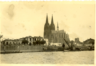
Photograph - black and white, Cologne Cathedral from the Rhine, c1950
... Barker Library (top floor) Mount Helen goldfields Cologne Cathedral is a renowned monument of German Catholicism and Gothic architecture and is a World Heritage Site. It is Germany's most visited landmark, attracting an average of 20,000 people a day. (Wikipedia) Though not targeted itself, the cathedral was very near to the central railway station ...Cologne Cathedral is a renowned monument of German Catholicism and Gothic architecture and is a World Heritage Site. It is Germany's most visited landmark, attracting an average of 20,000 people a day. (Wikipedia) Though not targeted itself, the cathedral was very near to the central railway station and suffered fourteen hits by aerial bombs during World War II. Badly damaged, it nevertheless remained standing in an otherwise completely flattened city. The twin spires were an easily recognizable navigational landmark for Allied aircraft bombing deeper into Germany, which may explain why the cathedral was spared. Repairs were completed in 1956. An emergency repair on the northwest tower's base carried out in 1944 using poor-quality brick taken from a nearby ruined building remained visible until 2005 as a reminder of the war, when it was decided to restore the section its original appearance. (Wikipedia) Black and white photograph showing a grand cathedral from a waterway. It is Cologne (Koln) Cathedral from the Rhine. To the left of the photo bombed buildings are evident. The photograph is believed to have been taken by Frank Wright.cologne cathedral, koln, germany, rhine, bombing, world war two, frank wright