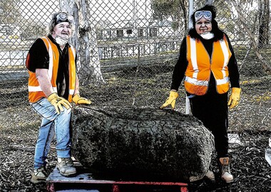
Showing 27 items matching "basalt rock"
-
 Bunjil Park Aboriginal Education & Cultural Centre
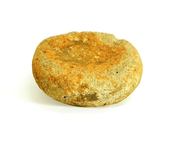
grinding stone, basalt rock grinding stone
... basalt rock grinding stone...Bunjil Park Aboriginal Education & Cultural Centre Neilborough goldfields basalt rock grinding stone grinding stone ... -
 Hume City Civic Collection
Photograph, Early 1990's
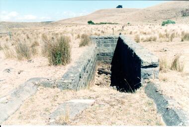
... ...basalt rock...A coloured photograph of the stone remains of a sheep dip constructed from basalt rock. The ground at the entrance slopes down into a narrow walled channel. ...The bluestone structure was a sheep dip on the 'Karoora Park' property near Jacksons Creek. stone structures sheep dips basalt rock 'karoora park' george evans collection A coloured photograph of the stone remains of a sheep dip constructed from basalt rock. ...This is a photograph of one of the many stone ruins which can be seen in the Sunbury area and surrounding districts. These ruins are found in varying degrees of structural damage caused by erosion, vegetation growth and vandalism. The bluestone structure was a sheep dip on the 'Karoora Park' property near Jacksons Creek.A coloured photograph of the stone remains of a sheep dip constructed from basalt rock. The ground at the entrance slopes down into a narrow walled channel. The surrounding paddocks are covered with tussocks of grass and there are bare hills in the background. The grass is brown.stone structures, sheep dips, basalt rock, 'karoora park', george evans collection -
 Hume City Civic Collection
Geological specimen
... A fossil of a small shell in a layer of sedimentary rock, which has formed above basalt rock....Fossils Shells Jacksons Creek Sunbury A fossil of a small shell in a layer of sedimentary rock, which has formed above basalt rock. Geological specimen ...The fossil was found by Mrs. D. Lee in 1983 in Jacksons Creek near the Palmas Reserve.A fossil of a small shell in a layer of sedimentary rock, which has formed above basalt rock.fossils, shells, jacksons creek, sunbury -
 Hume City Civic Collection
Photograph, Early 1990's
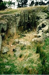
... A coloured photograph in portrait format of a basalt rock ruined structure which has been dug into a hillside with a line of trees in the background....This is the remains of a bluestone quarry on the 'Oaklands' property at Oaklands Junction. stone structures oaklands quarry george evans collection A coloured photograph in portrait format of a basalt rock ruined structure which has been dug into a hillside with a line of trees in the background. ...This is a photograph of one of the many stone ruins which can be seen in the Sunbury area and surrounding districts. These ruins are found in varying degrees of structural damage caused by erosion, vegetation growth and vandalism. This is the remains of a bluestone quarry on the 'Oaklands' property at Oaklands Junction.A coloured photograph in portrait format of a basalt rock ruined structure which has been dug into a hillside with a line of trees in the background.stone structures, oaklands quarry, george evans collection -
 The Beechworth Burke Museum
Geological specimen - Basalt (igneous-volcanic) containing Olivine, unknown
... basalt...igneous rock...Basalt is an aphanitic extrusive igneous rock formed from the rapid cooling of low-viscosity lava exposed at or very near the surface of a rocky planet or moon. ...Many of these specimens were sent to research and collecting organisations across Australia, including the Burke Museum, to educate and encourage further study. burke museum beechworth indigo shire beechworth museum geological geological specimen mineralogy basalt igneous rock igneous-volcanic volcanic geology volcanic olivine Olivine Specimen basaltoid Olivine in basalt / - label is probably / correct. / C. ...This particular geological specimen was found in Mount Franklin or Lalgambook in Djadjawurrung, located between Daylesford and Newstead, approximately ninety minutes drive from Melbourne. The mountain is an example of a breached scoria cone (a steep conical hill of loose pyroclastic fragments) which was created by a volcanic eruption about 470,000 years ago, a date which may indicate the age of this geological specimen. The volcanic eruptions of Mount Franklin were most likely witnessed by members of the Dja Dja Wurrung Aboriginal tribe, who referred to this country as the 'smoking grounds'. Mount Franklin and the surrounding area appears to have been a place of considerable religious significance to Aboriginal people, there is evidence which indicates that frequent large ceremonial gatherings took place in the area. Basalt is the most common rock on Earth’s surface, more than 90% of all volcanic rock on Earth is basalt. Basalt is an aphanitic extrusive igneous rock formed from the rapid cooling of low-viscosity lava exposed at or very near the surface of a rocky planet or moon. Specimens are black in colour and weather to dark green or brown. Basalt is rich in iron and magnesium and is mainly composed of olivine, pyroxene, and plagioclase. Olivine is the name of a group of rock-forming silicate minerals with compositions ranging between Mg2SiO4 and Fe2SiO4. Unlike other minerals, Olivine has a very high crystallisation temperature which makes it the first of the minerals to crystallise from magma. As magma cools, the crystals begin to form and settle on the bottom of the lava and form basalts that are abnormally enriched in olivine in the lower part of lava flows. According to H. M. King (on geology.com) "Olivine is thought to be an important mineral in Earth's mantle. Its presence as a mantle mineral has been inferred by a change in the behaviour of seismic waves as they cross the boundary between Earth's crust and mantle". Lava from Mount Franklin and other volcanoes in the area filled valleys and buried the gold bearing streams that became the renowned ‘deep leads’ of the gold mining era. In 1852, as part of the Victorian gold rush, gold was discovered in the immediate area, this gold was created by lava flows during the Newer Volcanic period, which were mined intensively during the nineteenth century. Around 1865 the presence of a deep lead in Mount Franklin was established. Deep lead mining was initially unsuccessful, and it was not until the late 1870s that the Franklinford Gold Mining Company mined at Mount Franklin on a significant scale. A few years later the Mount Franklin Estate Gold Mining Company also struck gold, followed by the Shakespeare and Great Western companies in the mid-1880s. By the late 1880s, however, deep lead mining had ceased in the area. Soon after gold was discovered in 1851, Victoria’s Governor La Trobe wrote to the Colonial Office in London, urging ‘the propriety of selecting and appointing as Mineral Surveyor for this Colony a gentleman possessed of the requisite qualifications and acquaintance with geological science and phenomena’. Alfred Selwyn was appointed geological surveyor in Australia in 1852 which began the Geological Survey of Victoria. In 1853-69 the Geological Survey issued under Selwyn's direction sixty-one geological maps and numerous reports; they were of such high standard that a writer in the Quarterly Journal of the Geological Society of London bracketed the survey with that of the United States of America as the best in the world. During his years spent in Australia, Selwyn collected numerous significant geological specimens, examples of which are held in collections such as the Burke Museum.This geological specimen is an example of basalt and olivine which shows the volcanic lava activity and geographical specific nature of Mt Franklin as a significant volcanic site. According to Agriculture Victoria 'The crater is one of the deepest in the Central Highlands area. It is a major megacryst site with some of the largest known Victorian examples of megacrysts of augite and an orthoclase. The small parasitic mound of Lady Franklin on the western flanks adds to the geological interest of the site'. This specimen also highlights the locality as a significant place for both indigenous activity and Victorian gold rush era mining practices. This specimen is part of a larger collection of geological and mineral specimens collected from around Australia (and some parts of the world) and donated to the Burke Museum between 1868-1880. A large percentage of these specimens were collected in Victoria as part of the Geological Survey of Victoria that begun in 1852 (in response to the Gold Rush) to study and map the geology of Victoria. Collecting geological specimens was an important part of mapping and understanding the scientific makeup of the earth. Many of these specimens were sent to research and collecting organisations across Australia, including the Burke Museum, to educate and encourage further study.An angular, solid hand-sized piece of grey volcanic Basalt with green/brown Olivine phenocrysts along one flat edge.Olivine in basalt / - label is probably / correct. / C. Willman / 15/4/21burke museum, beechworth, indigo shire, beechworth museum, geological, geological specimen, mineralogy, basalt, igneous rock, igneous-volcanic, volcanic geology, volcanic, olivine, olivine specimen, basaltoid -
 8th/13th Victorian Mounted Rifles Regimental Collection
Photograph
... Colour photograph of jaggered basalt rock covering most of high country SSW of Tindal RAAF Base, Northern Territory. ...Colour photograph of jaggered basalt rock covering most of high country SSW of Tindal RAAF Base, Northern Territory. ...In 1988, as part of a Defence of Mainland Australian policy, defence of facilities of strategic importance in northern Australia were allocated to Army Reserve units. ‘A’ Squadron was allocated the defence of Tindal Air Force base located 15 KM outside Katherine in Northern Territory. Consequently the Squadron deployed on Exercise ‘Northern Explorer’ to gain first-hand knowledge of operating conditions for mounted and dismounted patrolling in the area.Colour photograph of jaggered basalt rock covering most of high country SSW of Tindal RAAF Base, Northern Territory. Photo was taken to illustrate reports of patrols during Exercise " Northern Explorer" September 1988. -
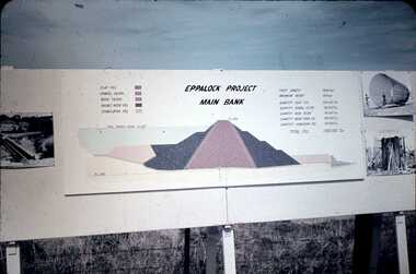 Bendigo Historical Society Inc.
Slide - DAVID MCDONALD COLLECTION: EPPALOCK. CONSTRUCTION, c1960
... Lake consists of clay fill, Gravel Filter, Rock Filter, Basalt Filter, Stabilizing Fill. Full Supply Level RL637. ...Lake consists of clay fill, Gravel Filter, Rock Filter, Basalt Filter, Stabilizing Fill. Full Supply Level RL637. ...Eppalock. Construction. Eppalock Project Main Bank. Lake consists of clay fill, Gravel Filter, Rock Filter, Basalt Filter, Stabilizing Fill. Full Supply Level RL637. Crest Length 2000 Feet, Maximum Height 150 Feet, Quantity Clay Fill 550 000 Ton, Quantity Gravel Filler 120000 Ton, Quantity Rock Filler 60 000 Ton, Quantity Basalt Rock Fill 250 000 Ton, Quantity Stabilizing Fill 150 000 Ton, Total Fill 1630 000 Ton. Markings: Eppalock Dam Observation Point Board.Agfacolorcivil engineering, water supply, eppalock -
![View of the Hanging Rock, near Mount Macedon / [by] Nicholas Caire, circa 1876](/media/collectors/550653872162f11fb04854aa/items/577745a4d0cdd10a5c1059fc/item-media/57774673d0cdd10a5c10a562/item-fit-380x285.jpg?cb=6) Kew Historical Society Inc
Kew Historical Society IncPhotograph, Anglo-Australasian Photographic Company, View of the Hanging Rock, near Mount Macedon, c. 1876
... Its formation is singularly peculiar, consisting of gigantic masses of basaltic rock / thrown up on end in a projecting or hanging position. ...Its formation is singularly peculiar, consisting of gigantic masses of basaltic rock / thrown up on end in a projecting or hanging position. ...Nicholas Caire was born on Guernsey in the Channel Islands in 1837. He arrived in Adelaide with his parents in about 1860. In 1867, following photographic journeys in Gippsland, he opened a studio in Adelaide. From 1870 to 1876 he lived and worked in Talbot in Central Victoria. In 1876 he purchased T. F. Chuck's studios in the Royal Arcade Melbourne. In 1885, following the introduction of dry plate photography, he began a series of landscape series, which were commercially successful. As a photographer, he travelled extensively through Victoria, photographing places few of his contemporaries had previously seen. He died in 1918. Reference: Jack Cato, 'Caire, Nicholas John (1837–1918)', Australian Dictionary of Biography.An original, rare photograph from the series 'Views of Victoria: General Series' by the photographer, Nicholas Caire (1837-1918). The series of 60 photographs that comprise the series was issued c. 1876 and reinforced a neo-Romantic view of the Australian landscape to which a growing nationalist movement would respond. Nicholas Caire was active as a photographer in Australia from 1858 until his death in 1918. His vision of the Australian bush and pioneer life had a counterpart in the works of Henry Lawson and other nationalist poets, authors and painters.Albumen Silver Photograph on Boardprinted in ink on support l.c.: VIEW OF THE "HANGING ROCK," NEAR MOUNT MACEDON. / COPYRIGHT REGISTERED. printed in ink (vertically) on support reverse u.c.l.: J.W. FORBES, Agent, printed in ink (vertically) on support reverse c.l.: ANGLO-AUSTRALASIAN PHOTOGRAPHIC COMPANY, MELBOURNE. printed in ink (vertically) on support reverse c.: VIEWS OF VICTORIA. / (GENERAL SERIES.) / No. 6. / VIEW OF THE "HANGING ROCK," NEAR MOUNT MACEDON. / The Hanging Rock is situated about 5 miles in a north-easterly direction from the Railway Station at Woodend, / and is a very picturesque spot. Its formation is singularly peculiar, consisting of gigantic masses of basaltic rock / thrown up on end in a projecting or hanging position. Our illustration represents but a portion of the Rock, as it / is not possible to obtain a view of the whole of it in one picture. The height of these large boulders of rock vary / from 150 to 200 feet. printed in ink (vertically) on support reverse l.c.l.: 10 Temple Court, Collins Street West.nicholas caire (1837-1918), landscape photography -
 The Beechworth Burke Museum
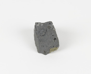
Geological specimen - Basalt, Unknown
... basalt specemin...indigo shire...Talbot...Cainozoic...igneous rock...This particular specimen was excavated from Talbot in Victoria, which was a small gold mining town established in 1852. As basalt is a common rock, it is not specific to Talbot. ...This particular type of Basalt was used mainly for roads due to the durability of the rock. Basalt holds significance due to the continued use of the rock from historic until present times. ...Basalt is a common igneous rock that composes most of the Earth's surface and can be found on the Moon and other rocky planets of the Solar System. It is generally composed minerals such as calcic plagioclase, clinopyroxene and iron ore which form grains that are indistinguishable to the naked eye. It can be dark grey or black in colouring and sometimes may contain holes left by gas bubbles. Most of the Earth's basalt was produced in environments such as oceanic divergent boundaries, oceanic hotspots, and mantle plumes and hotspots beneath continents. Basalt is commonly used in construction where it is crushed and used for multiple purposes such as concrete aggregate, road base, or railroad ballast. Thin slabs of basalt can also be cut and used for floor tiles, stone monuments, and building veneer. This particular specimen was excavated from Talbot in Victoria, which was a small gold mining town established in 1852. As basalt is a common rock, it is not specific to Talbot. However, this specimen can be assumed to be of the Cainozoic age due to previous geomorphic surveys of the area. This particular type of Basalt was used mainly for roads due to the durability of the rock.Basalt holds significance due to the continued use of the rock from historic until present times. The rock has been utilised for many types of construction and is still used for the same purposes today. Basalt also has significance to the Earth and other rocky planets of the Solar System as it makes up most of the planet's surface. This specimen is part of a larger collection of geological and mineral specimens collected from around Australia (and some parts of the world) and donated to the Burke Museum between 1868-1880. A large percentage of these specimens were collected in Victoria as part of the Geological Survey of Victoria that begun in 1852 (in response to the Gold Rush) to study and map the geology of Victoria. Collecting geological specimens was an important part of mapping and understanding the scientific makeup of the earth. Many of these specimens were sent to research and collecting organisations across Australia, including the Burke Museum, to educate and encourage further study.A smaller than hand sized rock specimen which is dark grey in colour with small holes and white deposits across its surface.Geological survey / [illegible] /burke museum, beechworth, geological specimen, geology, basalt, basalt specemin, indigo shire, talbot, cainozoic, igneous rock -
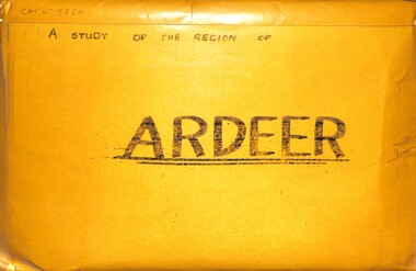 Sunshine and District Historical Society Incorporated
Archive - A Study Of The Region Of Ardeer, Sister Chanel (Sister Julia Williams), 1985
... There's Northing To Study 5384.02 - A Regional Study Of The Region Of Ardeer Page 8.jpg 1978 Municipal Directory 5384.02 - A Regional Study Of The Region Of Ardeer Page 9.jpg Text - Who Fosters It Image - House 5384.02 - A Regional Study Of The Region Of Ardeer Page 10.jpg Image - Market Gardens Yallourn Street Image - Yallourn Street 5384.02 - A Regional Study Of The Region Of Ardeer Page 11.jpg Image - Mother Of God Catholic Church Blanche Street Image - Mother Of God Catholic Church Blanche Street 5384.02 - A Regional Study Of The Region Of Ardeer Page 12.jpg Image - Scotch Thistles Image - Kororoit Creek Bridge West Street To Esmond Street 5384.02 - A Regional Study Of The Region Of Ardeer Page 13.jpg Image - Kororoit Creek Bridge Yalloun Street to Ballarat Road Image - Mother Of God Catholic Church Blanche Street 5384.02 - A Regional Study Of The Region Of Ardeer Page 14.jpg Text - Councillors, Politicians, People 5384.02 - A Regional Study Of The Region Of Ardeer Page 15.jpg Reality 5384.02 - A Regional Study Of The Region Of Ardeer Page 16.jpg Text - Geography Of The City Of Sunshine 5384.02 - A Regional Study Of The Region Of Ardeer Page 18.jpg Melway Map 5384.02 - A Regional Study Of The Region Of Ardeer Page 20.jpg Image - Kororoit Creek From Ballarat Road 5384.02 - A Regional Study Of The Region Of Ardeer Page 22.jpg Text - Basalt Sample Of A Basalt Rock When Laying Foundations For The Polish Community Hall In Helene Street 5384.02 - A Regional Study Of The Region Of Ardeer Page 23.jpg Image - Corner Yallourn Street And Rockbank Road Image - Tower Road Proposed Freeway Site (Now Scrapped) 5384.02 - A Regional Study Of The Region Of Ardeer Page 24.jpg Image - Kororoit Creek Bridge West Street To Esmond Street 5384.02 - A Regional Study Of The Region Of Ardeer Page 25.jpg Kororoit Creek Bridge West Street To Esmond Street 5384.02 - A Regional Study Of The Region Of Ardeer Page 26.jpg Image - Sunshine Swimming Pool Kororoit Creek 5384.02 - A Regional Study Of The Region Of Ardeer Page 27.jpg Text - Industry 5384.02 - A Regional Study Of The Region Of Ardeer Page 28.jpg Text - ICI 5384.02 - A Regional Study Of The Region Of Ardeer Page 29.jpg Text - ICINZ 5384.02 - A Regional Study Of The Region Of Ardeer Page 30.jpg Image - ICIANZ Ballarat Road Entrance 1979 Image - ICIANZ Explosive Reserve View From More Park Esmond Road 5384.02 - A Regional Study Of The Region Of Ardeer Page 31.jpg Image - Forrest Street Corner Fitzgerald Road Image - Entrance To ICIANZ Forrest Street 5384.02 - A Regional Study Of The Region Of Ardeer Page 32.jpg Image - Explosive Train Shunting Across Forrest Street 5384.02 - A Regional Study Of The Region Of Ardeer Page 33.jpg Image - Besco Batteries Forrest Street 5384.02 - A Regional Study Of The Region Of Ardeer Page 34.jpg Image - Queen Of Heaven Catholic Church Holt Street 5384.02 - A Regional Study Of The Region Of Ardeer Page 35.jpg Image - Ukrainian Catholic Church Forrest Street 5384.02 - A Regional Study Of The Region Of Ardeer Page 36.jpg Image - Mother Of God Catholic Church Blanche Street 5384.02 - A Regional Study Of The Region Of Ardeer Page 37.jpg Image - Ukrainian Hall Suspension Street Image - Polish Hall Helene Street 5384.02 - A Regional Study Of The Region Of Ardeer Page 38.jpg Image - Mother Of God Catholic Primary School Blanche Street 5384.02 - A Regional Study Of The Region Of Ardeer Page 39.jpg Image - Ardeer State School Looking From Suspension Street 5384.02 - A Regional Study Of The Region Of Ardeer Page 40.jpg Image - Polish Soccer Club Playgroup 5384.02 - A Regional Study Of The Region Of Ardeer Page 41.jpg Image - Holt Street Shopping Centre Image - Holt Street Milk Bar And Post Office 5384.02 - A Regional Study Of The Region Of Ardeer Page 42.jpg Image - 29 - 31 Maxwell Street Shopping Centre Image - 60 - 62 Maxwell Street Shopping Centre 5384.02 - A Regional Study Of The Region Of Ardeer Page 43.jpg Image - Motor Rail Train At Ardeer Station 5384.02 - A Regional Study Of The Region Of Ardeer Page 44.jpg Image - Ardeer Railway Station 5384.02 - A Regional Study Of The Region Of Ardeer Page 45.jpg Image - Railway Line Pedestrian Crossing Ardeer Station Ridgeway Parade To Forrest Street Image - Railway Line Pedestrian Crossing Ridgeway Parade To West Street 5384.02 - A Regional Study Of The Region Of Ardeer Page 46.jpg Image - Half House Image - Half House 5384.02 - A Regional Study Of The Region Of Ardeer Page 47.jpg Image - Small House Image - Vacant Block 5384.02 - A Regional Study Of The Region Of Ardeer Page 48.jpg Image - House Image - New House 5384.02 - A Regional Study Of The Region Of Ardeer Page 49.jpg Image - House 5384.02 - A Regional Study Of The Region Of Ardeer Page 50.jpg Image - Horse Riding School Forrest Street Image - Horse Riding School Forrest Street 5384.02 - A Regional Study Of The Region Of Ardeer Page 51.jpg Image - Kororoit Creek Image - Playground 5384.02 - A Regional Study Of The Region Of Ardeer Page 52.jpg Image - More Park Women's Sport Centre Esmond Street Image - Old Service Station Old Service Station 5384.02 - A Regional Study Of The Region Of Ardeer Page 53.jpg Image - Vegetable Garden Image - Vegetable Garden 5384.02 - A Regional Study Of The Region Of Ardeer Page 54.jpg Text - Open Space Analysis 5384.02 - A Regional Study Of The Region Of Ardeer Page 55.jpg 1976 Census 5384.02 - A Regional Study Of The Region Of Ardeer Page 56.jpg 1976 Census 5384.02 - A Regional Study Of The Region Of Ardeer Page 57.jpg 1979 Statistics 5384.02 - A Regional Study Of The Region Of Ardeer Page 58.jpg Text - Some Significant Realities 5384.02 - A Regional Study Of The Region Of Ardeer Page 59.jpg Text - A Typical Story From An Ardeerite 5384.02 - A Regional Study Of The Region Of Ardeer Page 60.jpg Text - Bibliography 5384.03 - A Regional Study Of The Region Of Ardeer - Donation Letter.jpg 5384.04 - A Regional Study Of The Region Of Ardeer - Sister Chanel Details.jpg ...There's Northing To Study 5384.02 - A Regional Study Of The Region Of Ardeer Page 8.jpg 1978 Municipal Directory 5384.02 - A Regional Study Of The Region Of Ardeer Page 9.jpg Text - Who Fosters It Image - House 5384.02 - A Regional Study Of The Region Of Ardeer Page 10.jpg Image - Market Gardens Yallourn Street Image - Yallourn Street 5384.02 - A Regional Study Of The Region Of Ardeer Page 11.jpg Image - Mother Of God Catholic Church Blanche Street Image - Mother Of God Catholic Church Blanche Street 5384.02 - A Regional Study Of The Region Of Ardeer Page 12.jpg Image - Scotch Thistles Image - Kororoit Creek Bridge West Street To Esmond Street 5384.02 - A Regional Study Of The Region Of Ardeer Page 13.jpg Image - Kororoit Creek Bridge Yalloun Street to Ballarat Road Image - Mother Of God Catholic Church Blanche Street 5384.02 - A Regional Study Of The Region Of Ardeer Page 14.jpg Text - Councillors, Politicians, People 5384.02 - A Regional Study Of The Region Of Ardeer Page 15.jpg Reality 5384.02 - A Regional Study Of The Region Of Ardeer Page 16.jpg Text - Geography Of The City Of Sunshine 5384.02 - A Regional Study Of The Region Of Ardeer Page 18.jpg Melway Map 5384.02 - A Regional Study Of The Region Of Ardeer Page 20.jpg Image - Kororoit Creek From Ballarat Road 5384.02 - A Regional Study Of The Region Of Ardeer Page 22.jpg Text - Basalt Sample Of A Basalt Rock When Laying Foundations For The Polish Community Hall In Helene Street 5384.02 - A Regional Study Of The Region Of Ardeer Page 23.jpg Image - Corner Yallourn Street And Rockbank Road Image - Tower Road Proposed Freeway Site (Now Scrapped) 5384.02 - A Regional Study Of The Region Of Ardeer Page 24.jpg Image - Kororoit Creek Bridge West Street To Esmond Street 5384.02 - A Regional Study Of The Region Of Ardeer Page 25.jpg Kororoit Creek Bridge West Street To Esmond Street 5384.02 - A Regional Study Of The Region Of Ardeer Page 26.jpg Image - Sunshine Swimming Pool Kororoit Creek 5384.02 - A Regional Study Of The Region Of Ardeer Page 27.jpg Text - Industry 5384.02 - A Regional Study Of The Region Of Ardeer Page 28.jpg Text - ICI 5384.02 - A Regional Study Of The Region Of Ardeer Page 29.jpg Text - ICINZ 5384.02 - A Regional Study Of The Region Of Ardeer Page 30.jpg Image - ICIANZ Ballarat Road Entrance 1979 Image - ICIANZ Explosive Reserve View From More Park Esmond Road 5384.02 - A Regional Study Of The Region Of Ardeer Page 31.jpg Image - Forrest Street Corner Fitzgerald Road Image - Entrance To ICIANZ Forrest Street 5384.02 - A Regional Study Of The Region Of Ardeer Page 32.jpg Image - Explosive Train Shunting Across Forrest Street 5384.02 - A Regional Study Of The Region Of Ardeer Page 33.jpg Image - Besco Batteries Forrest Street 5384.02 - A Regional Study Of The Region Of Ardeer Page 34.jpg Image - Queen Of Heaven Catholic Church Holt Street 5384.02 - A Regional Study Of The Region Of Ardeer Page 35.jpg Image - Ukrainian Catholic Church Forrest Street 5384.02 - A Regional Study Of The Region Of Ardeer Page 36.jpg Image - Mother Of God Catholic Church Blanche Street 5384.02 - A Regional Study Of The Region Of Ardeer Page 37.jpg Image - Ukrainian Hall Suspension Street Image - Polish Hall Helene Street 5384.02 - A Regional Study Of The Region Of Ardeer Page 38.jpg Image - Mother Of God Catholic Primary School Blanche Street 5384.02 - A Regional Study Of The Region Of Ardeer Page 39.jpg Image - Ardeer State School Looking From Suspension Street 5384.02 - A Regional Study Of The Region Of Ardeer Page 40.jpg Image - Polish Soccer Club Playgroup 5384.02 - A Regional Study Of The Region Of Ardeer Page 41.jpg Image - Holt Street Shopping Centre Image - Holt Street Milk Bar And Post Office 5384.02 - A Regional Study Of The Region Of Ardeer Page 42.jpg Image - 29 - 31 Maxwell Street Shopping Centre Image - 60 - 62 Maxwell Street Shopping Centre 5384.02 - A Regional Study Of The Region Of Ardeer Page 43.jpg Image - Motor Rail Train At Ardeer Station 5384.02 - A Regional Study Of The Region Of Ardeer Page 44.jpg Image - Ardeer Railway Station 5384.02 - A Regional Study Of The Region Of Ardeer Page 45.jpg Image - Railway Line Pedestrian Crossing Ardeer Station Ridgeway Parade To Forrest Street Image - Railway Line Pedestrian Crossing Ridgeway Parade To West Street 5384.02 - A Regional Study Of The Region Of Ardeer Page 46.jpg Image - Half House Image - Half House 5384.02 - A Regional Study Of The Region Of Ardeer Page 47.jpg Image - Small House Image - Vacant Block 5384.02 - A Regional Study Of The Region Of Ardeer Page 48.jpg Image - House Image - New House 5384.02 - A Regional Study Of The Region Of Ardeer Page 49.jpg Image - House 5384.02 - A Regional Study Of The Region Of Ardeer Page 50.jpg Image - Horse Riding School Forrest Street Image - Horse Riding School Forrest Street 5384.02 - A Regional Study Of The Region Of Ardeer Page 51.jpg Image - Kororoit Creek Image - Playground 5384.02 - A Regional Study Of The Region Of Ardeer Page 52.jpg Image - More Park Women's Sport Centre Esmond Street Image - Old Service Station Old Service Station 5384.02 - A Regional Study Of The Region Of Ardeer Page 53.jpg Image - Vegetable Garden Image - Vegetable Garden 5384.02 - A Regional Study Of The Region Of Ardeer Page 54.jpg Text - Open Space Analysis 5384.02 - A Regional Study Of The Region Of Ardeer Page 55.jpg 1976 Census 5384.02 - A Regional Study Of The Region Of Ardeer Page 56.jpg 1976 Census 5384.02 - A Regional Study Of The Region Of Ardeer Page 57.jpg 1979 Statistics 5384.02 - A Regional Study Of The Region Of Ardeer Page 58.jpg Text - Some Significant Realities 5384.02 - A Regional Study Of The Region Of Ardeer Page 59.jpg Text - A Typical Story From An Ardeerite 5384.02 - A Regional Study Of The Region Of Ardeer Page 60.jpg Text - Bibliography 5384.03 - A Regional Study Of The Region Of Ardeer - Donation Letter.jpg 5384.04 - A Regional Study Of The Region Of Ardeer - Sister Chanel Details.jpg A large envelope containing over 50 black & white photographs, statistics charts, several maps mounted on coloured card with text. ...Sister Chanel, was later known as Sister Julia Williams. She was professed on the 7th December 1963. She is mentioned in a history of the Brigidine Sister, by Morna Sturrock, Women of Strength, Women of Gentleness: Brigidine Sisters - Victoria Province, David Lovell Publishing, Victoria Australia, 1995, page 290. Sister Chanel (Sister Julia Williams) undertook a study of Ardeer in 1985, as part of her university studies. At the time, she was based at the Brigidine Convent in Blanche Street, Ardeer, opposite the Mother of God Catholic Primary School. Some years later, she was living at Unit 3, 387 Station Street, Bonbeach, Vic, 3196. Today, the Brigidine Convent at Ardeer no longer exists. The buildings have been demolished. The local schools begun by the Brigidine Sisters are now entirely staffed by lay teachers. There is a Brigidine Centre in Malvern, which contains archives relating to the Brigidine Sisters' history.The Brigidine Sisters (often misheard as “Bridiline”) are a long‑established Catholic religious congregation with a major historical presence in Melbourne, especially in education and social justice work. They arrived in Victoria in the 1880s and continue to operate schools, ministries, and community programs across the state.5384.01 - A Regional Study Of The Region Of Ardeer Envelope.jpg Text - A Regional Study Of The Region Of Ardeer 5384.02 - A Regional Study Of The Region Of Ardeer Page 1.jpg Text - A Regional Study Of The Region Of Ardeer 5384.02 - A Regional Study Of The Region Of Ardeer Page 2.jpg 5384.02 - A Regional Study Of The Region Of Ardeer Page 3.jpg Text - Subject HU211 Regionalism And Australia 5384.02 - A Regional Study Of The Region Of Ardeer Page 4.jpg Text - Ardeer Regions Selected 5384.02 - A Regional Study Of The Region Of Ardeer Page 5.jpg Melway Map 5384.02 - A Regional Study Of The Region Of Ardeer Page 6.jpg Text - Ardeer Never Heard Of It. Wheres That? 5384.02 - A Regional Study Of The Region Of Ardeer Page 7.jpg Text - Study The Region of Ardeer. There's Northing To Study 5384.02 - A Regional Study Of The Region Of Ardeer Page 8.jpg 1978 Municipal Directory 5384.02 - A Regional Study Of The Region Of Ardeer Page 9.jpg Text - Who Fosters It Image - House 5384.02 - A Regional Study Of The Region Of Ardeer Page 10.jpg Image - Market Gardens Yallourn Street Image - Yallourn Street 5384.02 - A Regional Study Of The Region Of Ardeer Page 11.jpg Image - Mother Of God Catholic Church Blanche Street Image - Mother Of God Catholic Church Blanche Street 5384.02 - A Regional Study Of The Region Of Ardeer Page 12.jpg Image - Scotch Thistles Image - Kororoit Creek Bridge West Street To Esmond Street 5384.02 - A Regional Study Of The Region Of Ardeer Page 13.jpg Image - Kororoit Creek Bridge Yalloun Street to Ballarat Road Image - Mother Of God Catholic Church Blanche Street 5384.02 - A Regional Study Of The Region Of Ardeer Page 14.jpg Text - Councillors, Politicians, People 5384.02 - A Regional Study Of The Region Of Ardeer Page 15.jpg Reality 5384.02 - A Regional Study Of The Region Of Ardeer Page 16.jpg Text - Geography Of The City Of Sunshine 5384.02 - A Regional Study Of The Region Of Ardeer Page 18.jpg Melway Map 5384.02 - A Regional Study Of The Region Of Ardeer Page 20.jpg Image - Kororoit Creek From Ballarat Road 5384.02 - A Regional Study Of The Region Of Ardeer Page 22.jpg Text - Basalt Sample Of A Basalt Rock When Laying Foundations For The Polish Community Hall In Helene Street 5384.02 - A Regional Study Of The Region Of Ardeer Page 23.jpg Image - Corner Yallourn Street And Rockbank Road Image - Tower Road Proposed Freeway Site (Now Scrapped) 5384.02 - A Regional Study Of The Region Of Ardeer Page 24.jpg Image - Kororoit Creek Bridge West Street To Esmond Street 5384.02 - A Regional Study Of The Region Of Ardeer Page 25.jpg Kororoit Creek Bridge West Street To Esmond Street 5384.02 - A Regional Study Of The Region Of Ardeer Page 26.jpg Image - Sunshine Swimming Pool Kororoit Creek 5384.02 - A Regional Study Of The Region Of Ardeer Page 27.jpg Text - Industry 5384.02 - A Regional Study Of The Region Of Ardeer Page 28.jpg Text - ICI 5384.02 - A Regional Study Of The Region Of Ardeer Page 29.jpg Text - ICINZ 5384.02 - A Regional Study Of The Region Of Ardeer Page 30.jpg Image - ICIANZ Ballarat Road Entrance 1979 Image - ICIANZ Explosive Reserve View From More Park Esmond Road 5384.02 - A Regional Study Of The Region Of Ardeer Page 31.jpg Image - Forrest Street Corner Fitzgerald Road Image - Entrance To ICIANZ Forrest Street 5384.02 - A Regional Study Of The Region Of Ardeer Page 32.jpg Image - Explosive Train Shunting Across Forrest Street 5384.02 - A Regional Study Of The Region Of Ardeer Page 33.jpg Image - Besco Batteries Forrest Street 5384.02 - A Regional Study Of The Region Of Ardeer Page 34.jpg Image - Queen Of Heaven Catholic Church Holt Street 5384.02 - A Regional Study Of The Region Of Ardeer Page 35.jpg Image - Ukrainian Catholic Church Forrest Street 5384.02 - A Regional Study Of The Region Of Ardeer Page 36.jpg Image - Mother Of God Catholic Church Blanche Street 5384.02 - A Regional Study Of The Region Of Ardeer Page 37.jpg Image - Ukrainian Hall Suspension Street Image - Polish Hall Helene Street 5384.02 - A Regional Study Of The Region Of Ardeer Page 38.jpg Image - Mother Of God Catholic Primary School Blanche Street 5384.02 - A Regional Study Of The Region Of Ardeer Page 39.jpg Image - Ardeer State School Looking From Suspension Street 5384.02 - A Regional Study Of The Region Of Ardeer Page 40.jpg Image - Polish Soccer Club Playgroup 5384.02 - A Regional Study Of The Region Of Ardeer Page 41.jpg Image - Holt Street Shopping Centre Image - Holt Street Milk Bar And Post Office 5384.02 - A Regional Study Of The Region Of Ardeer Page 42.jpg Image - 29 - 31 Maxwell Street Shopping Centre Image - 60 - 62 Maxwell Street Shopping Centre 5384.02 - A Regional Study Of The Region Of Ardeer Page 43.jpg Image - Motor Rail Train At Ardeer Station 5384.02 - A Regional Study Of The Region Of Ardeer Page 44.jpg Image - Ardeer Railway Station 5384.02 - A Regional Study Of The Region Of Ardeer Page 45.jpg Image - Railway Line Pedestrian Crossing Ardeer Station Ridgeway Parade To Forrest Street Image - Railway Line Pedestrian Crossing Ridgeway Parade To West Street 5384.02 - A Regional Study Of The Region Of Ardeer Page 46.jpg Image - Half House Image - Half House 5384.02 - A Regional Study Of The Region Of Ardeer Page 47.jpg Image - Small House Image - Vacant Block 5384.02 - A Regional Study Of The Region Of Ardeer Page 48.jpg Image - House Image - New House 5384.02 - A Regional Study Of The Region Of Ardeer Page 49.jpg Image - House 5384.02 - A Regional Study Of The Region Of Ardeer Page 50.jpg Image - Horse Riding School Forrest Street Image - Horse Riding School Forrest Street 5384.02 - A Regional Study Of The Region Of Ardeer Page 51.jpg Image - Kororoit Creek Image - Playground 5384.02 - A Regional Study Of The Region Of Ardeer Page 52.jpg Image - More Park Women's Sport Centre Esmond Street Image - Old Service Station Old Service Station 5384.02 - A Regional Study Of The Region Of Ardeer Page 53.jpg Image - Vegetable Garden Image - Vegetable Garden 5384.02 - A Regional Study Of The Region Of Ardeer Page 54.jpg Text - Open Space Analysis 5384.02 - A Regional Study Of The Region Of Ardeer Page 55.jpg 1976 Census 5384.02 - A Regional Study Of The Region Of Ardeer Page 56.jpg 1976 Census 5384.02 - A Regional Study Of The Region Of Ardeer Page 57.jpg 1979 Statistics 5384.02 - A Regional Study Of The Region Of Ardeer Page 58.jpg Text - Some Significant Realities 5384.02 - A Regional Study Of The Region Of Ardeer Page 59.jpg Text - A Typical Story From An Ardeerite 5384.02 - A Regional Study Of The Region Of Ardeer Page 60.jpg Text - Bibliography 5384.03 - A Regional Study Of The Region Of Ardeer - Donation Letter.jpg 5384.04 - A Regional Study Of The Region Of Ardeer - Sister Chanel Details.jpg -
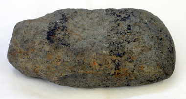 Orbost & District Historical Society
axe head
... basalt. This is able to withstand repeated impact making it suitable for use in objects such as stone axes. The stone was quarried, and then roughly shaped into a tool blank with blows from a hammerstone. The edges were then sharpened and refined by grinding the tool against a coarse, gritty rock...basalt. This is able to withstand repeated impact making it suitable for use in objects such as stone axes. The stone was quarried, and then roughly shaped into a tool blank with blows from a hammerstone. The edges were then sharpened and refined by grinding the tool against a coarse, gritty rock ...Inspected by Joanna Freslov, archaeologist 2.6.2008. Ground-edged axes first appeared in south-eastern Australia about 4,000 years ago and were used either with handles or hand-held. Stone tools were used for a variety of purposes, in ways similar to those of steel knives, axes, hammers and chisels. Ground-edge tools are made from fracture-resistant stone, such as basalt. This is able to withstand repeated impact making it suitable for use in objects such as stone axes. The stone was quarried, and then roughly shaped into a tool blank with blows from a hammerstone. The edges were then sharpened and refined by grinding the tool against a coarse, gritty rock. The necessary tools and equipment for hunting, fishing and warfare were one of the very few items that Aboriginals carried with them from place to place. Most were used for a multiplicity of purposes. Because many were made from raw natural materials, such as wood, generally only partial remains are found today. This item is an example of a stone tool used by the early Indigenous people of Eastern australia.A handmade stone Aboriginal axe head.axe-head aboriginal tool stone-artefact -
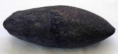 Orbost & District Historical Society
axe head
... basalt. This axe would able to withstand repeated impact. The stone would have been dug or found and then roughly shaped into a tool blank with blows from a hammerstone. The edges were then sharpened and refined by grinding the tool against a coarse, gritty rock. ...basalt. This axe would able to withstand repeated impact. The stone would have been dug or found and then roughly shaped into a tool blank with blows from a hammerstone. The edges were then sharpened and refined by grinding the tool against a coarse, gritty rock. ...Inspected by Joanna Freslov, archaeologist 2.6.2008. -unusual axe head. Ground-edge tools are made from fracture-resistant stone, such as basalt. This axe would able to withstand repeated impact. The stone would have been dug or found and then roughly shaped into a tool blank with blows from a hammerstone. The edges were then sharpened and refined by grinding the tool against a coarse, gritty rock. Ground-edge tools could be held in the hand, or fashioned to be fixed onto a haft or handle.The necessary tools and equipment for hunting, fishing and warfare were one of the very few items that Aboriginals carried with them from place to place. Most were used for a multiplicity of purposes. Because many were made from raw natural materials, such as wood, generally only partial remains are found today. This stone axe head is an example of a ground-edge tool used by the early Indigenous people in Eastern Australia.A handmade stone Aboriginal axe head.aboriginal tool aboriginal stone-artefact -
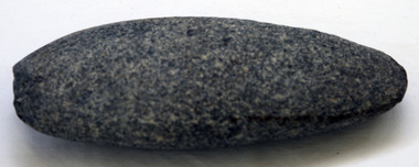 Orbost & District Historical Society
axe head
... basalt which is able to withstand repeated impact, and so is suitable for use in objects such as stone axes. The stone was quarried, and then roughly shaped into a tool blank with blows from a hammerstone. The edges were then sharpened and refined by grinding the tool against a coarse, gritty rock...basalt which is able to withstand repeated impact, and so is suitable for use in objects such as stone axes. The stone was quarried, and then roughly shaped into a tool blank with blows from a hammerstone. The edges were then sharpened and refined by grinding the tool against a coarse, gritty rock ...Inspected by Joanna Freslov, archaeologist 2.6.2008 Ground-edged axes first appeared in south-eastern Australia about 4,000 years ago and were used either with handles or hand-held. Stone tools were used for a variety of purposes, in ways similar to those of steel knives, axes, hammers and chisels. Ground-edge tools are made from fracture-resistant stone, such as basalt which is able to withstand repeated impact, and so is suitable for use in objects such as stone axes. The stone was quarried, and then roughly shaped into a tool blank with blows from a hammerstone. The edges were then sharpened and refined by grinding the tool against a coarse, gritty rockThe necessary tools and equipment for hunting, fishing and warfare were one of the very few items that Aboriginals carried with them from place to place. Most were used for a multiplicity of purposes. Because many were made from raw natural materials, such as wood, generally only partial remains are found today. This item is an example of an early axe head used by the Indigenous people of East Gippsland.A handmade stone Aboriginal axe head.aboriginal tool stone-artefact axe-head -
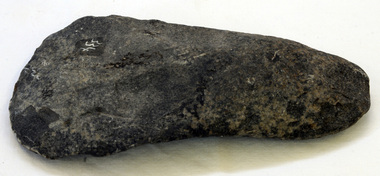 Orbost & District Historical Society
axe head
... basalt which is able to withstand repeated impact, and is suitable for use in objects such as stone axes. The stone was quarried, and then roughly shaped into a tool blank with blows from a hammerstone. The edges were then sharpened and refined by grinding the tool against a coarse, gritty rock...basalt which is able to withstand repeated impact, and is suitable for use in objects such as stone axes. The stone was quarried, and then roughly shaped into a tool blank with blows from a hammerstone. The edges were then sharpened and refined by grinding the tool against a coarse, gritty rock ...Inspected by Joonna Freslov, archaeologist 2.6.2008. Stone tools were used for a variety of purposes, in ways similar to those of steel knives, axes, hammers and chisels. Ground-edge tools are made from fracture-resistant stone, such as basalt which is able to withstand repeated impact, and is suitable for use in objects such as stone axes. The stone was quarried, and then roughly shaped into a tool blank with blows from a hammerstone. The edges were then sharpened and refined by grinding the tool against a coarse, gritty rock.The necessary tools and equipment for hunting, fishing and warfare were one of the very few items that Aboriginals carried with them from place to place. Most were used for a multiplicity of purposes. Because many were made from raw natural materials, such as wood, generally only partial remains are found today. This axe head is an example of an early stone tool used by the Indigenous people of Eastern Australia.A handmade stone Aboriginal axe head. Finger grips are clear.axehead aboriginal tool stone-artefact -
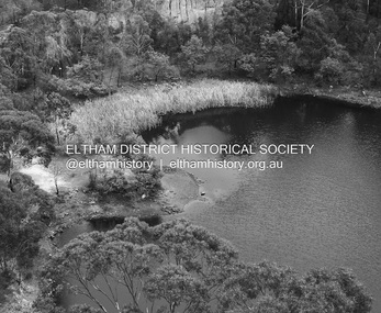 Eltham District Historical Society Inc
Photograph - Digital Photograph, Alan King, Blue Lake, Plenty Gorge Park, 2008
... On the Nillumbik side are undulating hills and sedimentary rock, and in Whittlesea, lies a basalt plain formed by volcanic action up to two million years ago. ...On the Nillumbik side are undulating hills and sedimentary rock, and in Whittlesea, lies a basalt plain formed by volcanic action up to two million years ago. ...A quarry was transformed into the Blue Lake. Published: Nillumbik Now and Then / Marguerite Marshall 2008; photographs Alan King with Marguerite Marshall.; p179 The dramatic steep-sided Plenty Gorge lies along the divide of two geological areas, and separates the Nillumbik Shire and the City of Whittlesea. On the Nillumbik side are undulating hills and sedimentary rock, and in Whittlesea, lies a basalt plain formed by volcanic action up to two million years ago. This provides the Plenty Gorge Park with diverse vegetation and habitats, making it one of Greater Melbourne’s most important refuges for threatened and significant species. The park, established in 1986, consists of around 1350 hectares, and extends 11 kilometres along the Plenty River, from Greensborough to Mernda. It provides a wildlife corridor for around 500 native plant and 280 animal species. The area’s plentiful food and water attracted the Wurundjeri Aboriginal people and then European settlers. By 1837 squatters had claimed large runs of land for their sheep and cattle. The Plenty Valley was among the first in the Port Phillip District to be settled - mainly in the less heavily timbered west - and was proclaimed a settled district in 1841.But by the late 1880s, the settlers’ extensive land clearing for animal grazing, then agriculture, depleted the Wurundjeri’s traditional food sources, which helped to drive them away. Many Wurundjeri artefacts remain (now government protected), and so far 57 sites have been identified in the park, including scarred trees, burial areas and stone artefacts. Pioneer life could be very hard because of isolation, flooding, bushfires and bushrangers. Following the Black Thursday bushfires of 1851, basalt was quarried to build more fire-resistant homes. Gold discoveries in the early 1850s swelled the population, particularly around Smugglers Gully; but food production made more of an impact. In the late 1850s wheat production supplanted grazing. In the 1860s the government made small holdings available to poorer settlers. These had the greatest effect on the district, particularly in Doreen and Yarrambat, where orchards were established from the 1880s to 1914. Links with a prominent early family are the remains of Stuchbery Farm, by the river’s edge bounded by Smugglers Gully to the north and La Trobe Road, Yarrambat, to the east. The Stuchberys moved to the valley in 1890, and the family still lives in the area. In 1890, Alfred and Ada first lived in a tent where four children were born, then Alfred built the house and outbuildings around 1896. They planted an orchard, then a market garden, and developed a dairy. The family belonged to the local Methodist and tennis communities. Their grandson Walter, opened the Flying Scotsman Model Railway Museum in Yarrambat, which his widow, Vi, continues to run. Wal was also the Yarrambat CFA Captain for 22 years until 1987. Walter sold 24 hectares in 1976 for development - now Vista Court - and in 1990, the remaining 22.6 hectares for the park. Remaining are an early stone dairy and remnants of a stone barn, a pig sty and a well. Until it was destroyed by fire in 2003, a slab hut stood on the Happy Hollow Farm site, at the southern end of the park. The hut is thought to have been built in the Depression around 1893. This was a rare and late example of a slab hut with a domestic orchard close to Melbourne. Emmet Watmough and his family first occupied the hut, followed by a succession of families, until the Bell family bought it around 1948. There they led a subsistence lifestyle for 50 years, despite encroaching Melbourne suburbia. The Yellow Gum Recreation Area includes the Blue Lake, coloured turquoise at certain times of the year. Following the 1957 bushfires, this area was quarried by Reid Quarries Pty Ltd for Melbourne’s first skyscrapers, then by Boral Australia. However in the early 1970s water began seeping into the quarry forming the Blue Lake and the quarry was closed. The State Government bought the site in 1997 and opened it as a park in 1999.This collection of almost 130 photos about places and people within the Shire of Nillumbik, an urban and rural municipality in Melbourne's north, contributes to an understanding of the history of the Shire. Published in 2008 immediately prior to the Black Saturday bushfires of February 7, 2009, it documents sites that were impacted, and in some cases destroyed by the fires. It includes photographs taken especially for the publication, creating a unique time capsule representing the Shire in the early 21st century. It remains the most recent comprehenesive publication devoted to the Shire's history connecting local residents to the past. nillumbik now and then (marshall-king) collection, blue lake, plenty gorge park -
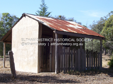 Eltham District Historical Society Inc
Photograph - Digital Photograph, Marguerite Marshall, Stuchbery Farm dairy, 14 March 2008
... On the Nillumbik side are undulating hills and sedimentary rock, and in Whittlesea, lies a basalt plain formed by volcanic action up to two million years ago. ...On the Nillumbik side are undulating hills and sedimentary rock, and in Whittlesea, lies a basalt plain formed by volcanic action up to two million years ago. ...Stuchbery Farm was situated on the Plenty River bounded by Smugglers Gully to the north and La trobe Road, Yarrambat, to the east. Alan and Ada Stutchbery moved to the valley in 1890, first living in a tent where four children were born. Alfred built a home and outbuildings around 1896. They planted an orchard, then a market garden and developed a dairy. Published: Nillumbik Now and Then / Marguerite Marshall 2008; photographs Alan King with Marguerite Marshall.; p179 The dramatic steep-sided Plenty Gorge lies along the divide of two geological areas, and separates the Nillumbik Shire and the City of Whittlesea. On the Nillumbik side are undulating hills and sedimentary rock, and in Whittlesea, lies a basalt plain formed by volcanic action up to two million years ago. This provides the Plenty Gorge Park with diverse vegetation and habitats, making it one of Greater Melbourne’s most important refuges for threatened and significant species. The park, established in 1986, consists of around 1350 hectares, and extends 11 kilometres along the Plenty River, from Greensborough to Mernda. It provides a wildlife corridor for around 500 native plant and 280 animal species. The area’s plentiful food and water attracted the Wurundjeri Aboriginal people and then European settlers. By 1837 squatters had claimed large runs of land for their sheep and cattle. The Plenty Valley was among the first in the Port Phillip District to be settled - mainly in the less heavily timbered west - and was proclaimed a settled district in 1841. But by the late 1880s, the settlers’ extensive land clearing for animal grazing, then agriculture, depleted the Wurundjeri’s traditional food sources, which helped to drive them away. Many Wurundjeri artefacts remain (now government protected), and so far 57 sites have been identified in the park, including scarred trees, burial areas and stone artefacts. Pioneer life could be very hard because of isolation, flooding, bushfires and bushrangers. Following the Black Thursday bushfires of 1851, basalt was quarried to build more fire-resistant homes. Gold discoveries in the early 1850s swelled the population, particularly around Smugglers Gully; but food production made more of an impact. In the late 1850s wheat production supplanted grazing. In the 1860s the government made small holdings available to poorer settlers. These had the greatest effect on the district, particularly in Doreen and Yarrambat, where orchards were established from the 1880s to 1914. Links with a prominent early family are the remains of Stuchbery Farm, by the river’s edge bounded by Smugglers Gully to the north and La Trobe Road, Yarrambat, to the east. The Stuchberys moved to the valley in 1890, and the family still lives in the area. In 1890, Alfred and Ada first lived in a tent where four children were born, then Alfred built the house and outbuildings around 1896. They planted an orchard, then a market garden, and developed a dairy. The family belonged to the local Methodist and tennis communities. Their grandson Walter, opened the Flying Scotsman Model Railway Museum in Yarrambat, which his widow, Vi, continues to run. Wal was also the Yarrambat CFA Captain for 22 years until 1987. Walter sold 24 hectares in 1976 for development - now Vista Court - and in 1990, the remaining 22.6 hectares for the park. Remaining are an early stone dairy and remnants of a stone barn, a pig sty and a well. Until it was destroyed by fire in 2003, a slab hut stood on the Happy Hollow Farm site, at the southern end of the park. The hut is thought to have been built in the Depression around 1893. This was a rare and late example of a slab hut with a domestic orchard close to Melbourne. Emmet Watmough and his family first occupied the hut, followed by a succession of families, until the Bell family bought it around 1948. There they led a subsistence lifestyle for 50 years, despite encroaching Melbourne suburbia. The Yellow Gum Recreation Area includes the Blue Lake, coloured turquoise at certain times of the year. Following the 1957 bushfires, this area was quarried by Reid Quarries Pty Ltd for Melbourne’s first skyscrapers, then by Boral Australia. However in the early 1970s water began seeping into the quarry forming the Blue Lake and the quarry was closed. The State Government bought the site in 1997 and opened it as a park in 1999.This collection of almost 130 photos about places and people within the Shire of Nillumbik, an urban and rural municipality in Melbourne's north, contributes to an understanding of the history of the Shire. Published in 2008 immediately prior to the Black Saturday bushfires of February 7, 2009, it documents sites that were impacted, and in some cases destroyed by the fires. It includes photographs taken especially for the publication, creating a unique time capsule representing the Shire in the early 21st century. It remains the most recent comprehenesive publication devoted to the Shire's history connecting local residents to the past. nillumbik now and then (marshall-king) collection, ada stuchbery, alan stuchbery, dairy, stuchbery farm, farm buildings, yarrambat, plenty gorge park -
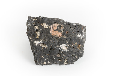
 The Beechworth Burke Museum
Geological specimen - Hyalite in Basalt
... According to the 1912 Department of Mines Bulletin of the Geological Survey of Victoria, basalt covers a considerable portion of the Macedon area including Mount Macedon. Basalt is the most common form of rock underlying the earth's surface and is found in three kinds of rock forming environments: ocean divergent boundaries, oceanic hotspots, and mantle plumes and hotspots beneath continents....Basalt is dark in colour, fine-grained igneous rock composed of plagioclase and pyroxene minerals. ...Basalt is dark in colour, fine-grained igneous rock composed of plagioclase and pyroxene minerals. ...According to the 1912 Department of Mines Bulletin of the Geological Survey of Victoria, basalt covers a considerable portion of the Macedon area including Mount Macedon. Basalt is the most common form of rock underlying the earth's surface and is found in three kinds of rock forming environments: ocean divergent boundaries, oceanic hotspots, and mantle plumes and hotspots beneath continents.This specimen is part of a larger collection of geological and mineral specimens collected from around Australia (and some parts of the world) and donated to the Burke Museum between 1868-1880. A large percentage of these specimens were collected in Victoria as part of the Geological Survey of Victoria that begun in 1852 (in response to the Gold Rush) to study and map the geology of Victoria. Collecting geological specimens was an important part of mapping and understanding the scientific makeup of the earth. Many of these specimens were sent to research and collecting organisations across Australia, including the Burke Museum, to educate and encourage further study.A solid mass, geological specimen in shades of grey and white. Hyalite is a colourless variety of opal. It occurs as globular and botryoidal masses and irregular crusts in volcanic and pegmatite environments where the silica deposits from the gas phase. Basalt is dark in colour, fine-grained igneous rock composed of plagioclase and pyroxene minerals. It is commonly formed as an extrusive rock, such as lava flow. It is one of the most common forms of rock underlying the earth's surface.burke museum, geological specimen, department of mines, geological survey of victoria, basalt, mount macedon, beechworth -
 The Beechworth Burke Museum
Geological specimen - Basalt
... Basalt is dark in colour, often black and has a fine grain. It is composed of plagioclase and pyroxene minerals and an igneous rock. ...Basalt is dark in colour, often black and has a fine grain. It is composed of plagioclase and pyroxene minerals and an igneous rock. ...This specimen was recovered from Creswick in Victoria. Basalt is dark in colour, often black and has a fine grain. It is composed of plagioclase and pyroxene minerals and an igneous rock. This specimen is part of a larger collection of geological and mineral specimens collected from around Australia (and some parts of the world) and donated to the Burke Museum between 1868-1880. A large percentage of these specimens were collected in Victoria as part of the Geological Survey of Victoria that begun in 1852 (in response to the Gold Rush) to study and map the geology of Victoria. Collecting geological specimens was an important part of mapping and understanding the scientific makeup of the earth. Many of these specimens were sent to research and collecting organisations across Australia, including the Burke Museum, to educate and encourage further study.A cylindrical fine-grained piece of igneous rockburke museum, geological survey of victoria, geological specimen, geology -
 Phillip Island and District Historical Society Inc.
Photograph, Dr G Baker
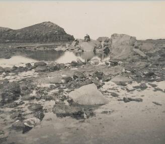
... Phillip Island and District Historical Society Inc. phillip-island-and-the-bass-coast One of a collection of over 400 photographs in an album commenced in 1960 and presented to the Phillip Island & Westernport Historical Society by the Shire of Phillip Island local history photography rock formations black & white photograph coastline smith's beach Dr G Baker John Jenner Bryant West Photograph of inter basaltic formations on basalt shore platform eastern end of Smith's Beach Photograph Bryant West Dr G Baker ...One of a collection of over 400 photographs in an album commenced in 1960 and presented to the Phillip Island & Westernport Historical Society by the Shire of Phillip IslandPhotograph of inter basaltic formations on basalt shore platform eastern end of Smith's Beachlocal history, photography, rock formations, black & white photograph, coastline, smith's beach, dr g baker, john jenner, bryant west -
 Phillip Island and District Historical Society Inc.
Photograph
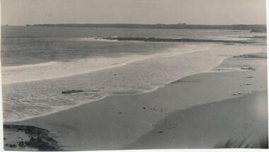
... basalt jetty...surf beach...black & white photograph...coastline...geology...rock...Phillip Island and District Historical Society Inc. phillip-island-and-the-bass-coast One of a collection of over 400 photographs in an album commenced in 1960 and presented to the Phillip Island & Westernport Historical Society by the Shire of Phillip Island local history photography basalt jetty surf beach black & white photograph coastline geology rock formations John Jenner Bryant West Photograph of the basalt Jetty and geological feature near Surf Beach Photograph Bryant West ...One of a collection of over 400 photographs in an album commenced in 1960 and presented to the Phillip Island & Westernport Historical Society by the Shire of Phillip IslandPhotograph of the basalt Jetty and geological feature near Surf Beachlocal history, photography, basalt jetty, surf beach, black & white photograph, coastline, geology, rock formations, john jenner, bryant west -
 Phillip Island and District Historical Society Inc.
Photograph
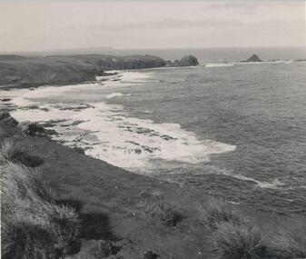
... Photograph of the basalt cliffs and shore platform near Pyramid Rock...Phillip Island and District Historical Society Inc. phillip-island-and-the-bass-coast One of a collection of over 400 photographs in an album commenced in 1960 and presented to the Phillip Island & Westernport Historical Society by the Shire of Phillip Island local history photography cliffs and shoreline pyramid rock black & white photograph coastline rock formations pyramid rock Dr A B Edwards John Jenner Bryant West Photograph of the basalt cliffs and shore platform near Pyramid Rock Photograph John Jenner Bryant West ...One of a collection of over 400 photographs in an album commenced in 1960 and presented to the Phillip Island & Westernport Historical Society by the Shire of Phillip IslandPhotograph of the basalt cliffs and shore platform near Pyramid Rocklocal history, photography, cliffs and shoreline pyramid rock, black & white photograph, coastline, rock formations, pyramid rock, dr a b edwards, john jenner, bryant west -
 Coal Creek Community Park & Museum
Bluestone fragment
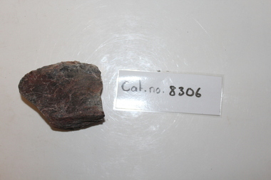
... Clearly a fragment of a river rock- one surface is smooth and curved the others planar. Mineralogy is basalt-"bluestone"-with white veins of secondary quartz minralisation...Coal Creek Community Park & Museum 12 Silkstone Road Korumburra gippsland largely unknown; ultimately originated as part of series of basaltic volcanic events across victoria Clearly a fragment of a river rock- one surface is smooth and curved the others planar. ...largely unknown; ultimately originated as part of series of basaltic volcanic events across victoriaClearly a fragment of a river rock- one surface is smooth and curved the others planar. Mineralogy is basalt-"bluestone"-with white veins of secondary quartz minralisation -
 Sunshine and District Historical Society Incorporated
Photograph - The Walan-walan 'Bug Rug' Sculptor Kororoit Creek Sunshine West, Bajada C, Melchior, 16th August 2022
... Ref: Friends of the Kororoit Creek Aboriginal Aborigine First Nation Kororoit Creek Sunshine West 3008.01 - The Walan-walan 'Bug Rug' Sculptor - Artists (L-R) Kenneth McKean & Fiona Clarke 3008.02 - The Walan-walan 'Bug Rug' Sculptor - Artists engraving a rock 3008.03 - The Walan-walan 'Bug Rug' Sculptor - Artists examining an engraved rock 3008.04 - The Walan-walan 'Bug Rug' Sculptor - Artists washing an engraved rock 3008.05 - The Walan-walan 'Bug Rug' Sculptor - Artist Fiona Clarke washing an engraved rock 3008.06 - The Walan-walan 'Bug Rug' Sculptor - Engraved rock 3008.07 - The Walan-walan 'Bug Rug' Sculptor - Engraved rock 3008.08 - The Walan-walan 'Bug Rug' Sculptor - Engraved rock 3008.09 - The Walan-walan 'Bug Rug' Sculptor - Rocks on palents prior to engraving 3008.10 - The Walan-walan 'Bug Rug' Sculptor - Collection of miscelleous photographs Collection of color photographs of the carvings on 6 large Basalt Blue stone Boulders at The Hunt Club Community Centre Photograph The Walan-walan 'Bug Rug' Sculptor Kororoit Creek Sunshine West Bajada C, Melchior ...After the completion of the carvings of these 6 large Basalt Blue stone Boulders they placed in a permanent position on the Kororoit Creek Trail on the west side of the creek approximately halfway between Derby Road and Wright Street. |What is Walan-walan? Walan-walan is a sculpture project at The Bug Rug by Fiona Clarke & Kenneth McKean Walan-walan means circle /round in Wurundjeri Woi Wurrung language. The circle has more than one meaning in First Nations cultures. In this case it represents the annual cycle of the year. Other important meanings include as a symbol for a meeting place or a body of water. The sculptures forming the circle are based on animal elemental signs of nature from local Aboriginal seasons. Wumangurruditj - Wombat, Ilk - Eel, Common Brown Butterfly, Gurrborra - Koala, Pied Currawong, Goanna and Buliyong - Bat. Many First Nations stories handed down over thousands of years often included mention of stars. Fiona and Ken have added glow in the dark resin to the artworks. This will gently illuminate them at night giving them a constellatory effect. The circle is relatable in many cultures. Walan-walan is a place where people come to sit and learn or simply to talk and rest in nature. It has many uses but will firstly honour the original First Nations Custodians past, present and future, who took extremely good care of this land for 60k + years. Ref: Friends of the Kororoit Creek3008.01 - The Walan-walan 'Bug Rug' Sculptor - Artists (L-R) Kenneth McKean & Fiona Clarke 3008.02 - The Walan-walan 'Bug Rug' Sculptor - Artists engraving a rock 3008.03 - The Walan-walan 'Bug Rug' Sculptor - Artists examining an engraved rock 3008.04 - The Walan-walan 'Bug Rug' Sculptor - Artists washing an engraved rock 3008.05 - The Walan-walan 'Bug Rug' Sculptor - Artist Fiona Clarke washing an engraved rock 3008.06 - The Walan-walan 'Bug Rug' Sculptor - Engraved rock 3008.07 - The Walan-walan 'Bug Rug' Sculptor - Engraved rock 3008.08 - The Walan-walan 'Bug Rug' Sculptor - Engraved rock 3008.09 - The Walan-walan 'Bug Rug' Sculptor - Rocks on palents prior to engraving 3008.10 - The Walan-walan 'Bug Rug' Sculptor - Collection of miscelleous photographsaboriginal, aborigine, first nation, kororoit creek, sunshine west -
 Clunes Museum
Geological specimen - ROCK SAMPLES
... Clunes Museum 36 Fraser Street enter building through Collins Place Clunes goldfields basalt geological specimens Nil Diamond sawn samples of basalt showing grain structure Geological specimen ROCK SAMPLES ...Diamond sawn samples of basalt showing grain structureNilbasalt, geological specimens -
 Sunbury Family History and Heritage Society Inc.
Photograph, Bulla Bridge
... Many bridges in the South West of Victoria were constructed from Bluestone basalt rock because the area is on a large volcanic plain and that rock is in abundance. ...A coloured photograph of the local heritage listed bluestone bridge which spans Deep Creek at Bulla. The photograph is taken facing upstream. The bridge was constructed in 1869 and replaced a ford crossing further downstream. Many bridges in the South West of Victoria were constructed from Bluestone basalt rock because the area is on a large volcanic plain and that rock is in abundance. A non-digital coloured photograph of the Bulla Bridge which spans the Deep Creek at Bulla. Photograph 0178 is an identical photograph tO this one.bridges, bulla bridge -
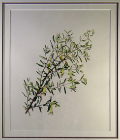 Brimbank City Council Art Collection
Painting, Correa Glabra (Rock or Smooth Corea), 1994
... Basalt Plains. Part of series of 14 commissioned paintings. Correa Glabra (Rock or Smooth Corea) Painting Helene Wild ...Local Indigenous PlantWatercolour paintings - Indigenous Plants of the Basalt Plains. Part of series of 14 commissioned paintings. -
 Bendigo Historical Society Inc.
Slide - Dunn's Rock Eppalock, 2012
... rock up to 65 million years old, which was originally deposited deep under the sea. Rocks mainly are sandstone, mudstone, black shale and quartz conglomerates. Marine fossils can be found in the area. Around seven million years ago a basalt...rock up to 65 million years old, which was originally deposited deep under the sea. Rocks mainly are sandstone, mudstone, black shale and quartz conglomerates. Marine fossils can be found in the area. Around seven million years ago a basalt ...The low rolling hills of the Kimbolton countryside consist of ancient, hard and fractured Ordovician rock up to 65 million years old, which was originally deposited deep under the sea. Rocks mainly are sandstone, mudstone, black shale and quartz conglomerates. Marine fossils can be found in the area. Around seven million years ago a basalt flow buried the original bedrock along the along the Campaspe River. Ongoing weathering, wind and water movement over the following years has produced younger clay, sand, silt and gravel deposits throughout the area. Patches of White Hills Gravel are also found in the area. Another unique geological feature of this area is the Permian Glacial Pavement rocks north and south of Eppalock and glacial sediments (such as “Dunn’s Rock” and “Kellams Rock”). During the ice age (up to 280 million years ago) large glaciers moving over the countryside, scoured out sediments, pulverized bedrock, polished and cut grooves into bedrock in the direction of ice movement. When the ice melted boulders etc where left behind in areas of entirely different rock types, such as a 100 Tonne granite block known as ‘The Stranger’ near Derrinal. Dunn's Rock (Glaciated Pavement) Eppalock - Photos of the rock and a field group collecting data with Lake Eppalock (Knowsley) in the backgroundhistory, bendigo, dunn's rock eppalock, kimbolton forest, lake eppalock, gately collection