Showing 41 items matching "batman's map"
-
 Federation University Historical Collection
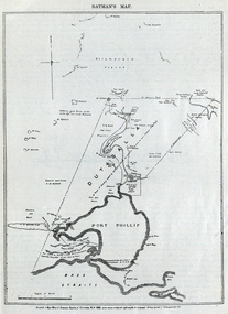
Image, Batman's Map of Port Phillip
... Batman's Map of Port Phillip...John Batman's map of Port Phillip showing Dutigalla...." John Batman's map of Port Phillip showing Dutigalla (Batman's ...Scanned from "The Old Pioneers' Memorial History of Melbourne From the Discovery of Port Phillip to the World War". It is a facsimile map from the House of Commons Reports of Committee.John Batman's map of Port Phillip showing Dutigalla (Batman's Tract), a township reserve, open plains, public common reserve, fresh water"A tract of country [called?] by the native chief of Southern Ausralia to be John Batman 6th June 1935."port phillip bay, john batman, melbourne, iramoo, r. sarsh, river sarsh, river batman, yarra river -
 Federation University Historical Collection
Book, The Old Pioneers' Memorial History of Melbourne From the Discovery of Port Phillip to the World War, 1924
... batman's map... old cemetery john batman edmund hobson batman's map st francis ...Blue hard covered book of 494 pages. Images, and a large plan of prominent burials in the Melbourne Old Cemetery, and a Map of Melbourne. melbourne, melbourne cemetery, melbourne old cemetery, john batman, edmund hobson, batman's map, st francis' church, james balfour, mrs hornbrook, paddy's market, wilson hall, working men's college, henry kendall, le souef's cottage, world war one, westernport, melbourne cup, hoddle, collingwood, south melbourne, prahran, richmond, kew, brunswick, coburg, preston, hawthorn, camberwell, nunawading, doncaster, st kilda, brighton, sandringham, cheltenham, caulfield, oalkleigh, footscray, sunshine, north melbourne, carlton, ballarat school of art library, ballarat technical art school, book plate, library plate, hume and hovell's overland journey 1824-5, major mtichell's overland journey, australia felix, booplate, aborigine, aboriginal, captain cook, arthur phillip, isaac smith, george bass, matthew flinders, john murray, catain baudain, captain collins, edward henty, portalnd, map od melbourne in 1938, john pascoe fawkner, the "enterprise: and fawkner's first home, old colonists' homes, rushall crescent north fitszroy, richard bourke, the old melbourne post offfice, old governmnt house, toorak, latrobe's house at jolimont, first melbourne land sale, melbourne water supply, peter henry smith, victorian legislative council opening, map of melbourne and collingwood, prince's bridge, crossing the rivers by punt, f.a> rucker, canvas city emerald hill, arrival of the gold escort in melbourne, the yarra, queen's wharf, tall ships, old st james, mary e. budd, st francis church, michael carr, meolbourne city mission, state library of victoria, melbourne public library, bourke street, angus mcmilan, methodist ladies college, ormond college, armistance celebrations, robert russell, mia mia, theatre royal bouke st, melbourne from flaggstaff hill, federal coffee palace collins st, lord melbourne, melbourne mint, old melbourne town hall, robert russell's melbourne and yarra falls, mandevalle hall, point lansdale lighthouse, wilson's promontory, margaret m. ward cole, williamstown, flinders st melbourne, queenscliff battery, broadmeadows soldiers' camp, embarkation of first troops on the 'ceramic', general monsash, ian hamilton, general bridges, victorian war memorial, national war memorial, st kilda pier, first melbourne cup, hoddle's grid, albert park, melbourne mechanic's institute, st kilda toll gate, munted policeman, springthorpe memorial, james bonwick, mornane's paddock, victorian railways melbourne and surburban lines, carlton gardens, thomas napier, wiliam westgarth, george augustus robinson, william lonsdale, elizabeth mary batman, peomena frances darling batman, dig tree, exhibition of 1854, exhibition of 1866, exhibition buildings, geelong harbour, jubilee lake, port campbell, warrnambool, queenscliff lightboat, batman's first house -
![Map - Maps, [John Batman in Melbourne], 1976](/media/collectors/4f729f5697f83e03086015b8/items/60965f673c71fad916b3a651/item-media/60965fc33c71fad916b3a805/item-fit-380x285.jpg) Greensborough Historical Society
Greensborough Historical SocietyMap - Maps, [John Batman in Melbourne], 1976
... Photocopies of 4 maps showing aspects of John Batman's time... aspects of John Batman's time in Melbourne: Map of the settlement ...Photocopies of 4 maps showing aspects of John Batman's time in Melbourne: Map of the settlement of the Yarra 1837; Batman's map of Port Phillip and his route of exploration, 1835, drawn by Wedge; Proposed route of Batman's initial exploratiion, and Enlargement of the Geelong region of Batman's map. No citations on any copy.Photocopy of maps, 4 pages.john batman, melbourne, port phillip -
 Greensborough Historical Society
Booklet, The History of the City of Melbourne, 1997_11
The history of the Melbourne City councilHistorical notes on the foundation of Melbourne and the creation and growth of the Melbourne Cricket Club.44 page booklet, printed in black and white, illus., maps. With gold highlighting on the outer coversNilmelbourne settlement, melbourne landsales, melbourne local government, john batman, john pascoe fawkner -
 Greensborough Historical Society
Journal - Article, Journal, Victorian Historical Journal, Batman's route revisited: his exact steps to a new treaty site, 2014_06
... batmans treaty 21 pages, maps. Batman's route revisited: his exact ...Article from the Victorian Historical Journal Vol.85, No.1, June 2014. Discusses John Batman's 1835 visit to Port Phillip and possible alternative sites for signing his treaty with Indigenous people of the area.21 pages, maps.john batman, batmans treaty -
 Greensborough Historical Society
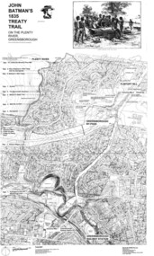
Map, Dennis Ward, John Batman's 1835 Treaty Trail on the Plenty River, 2010_
Map of the Plenty River through Greensborough and surrounding areas, annotated with historic places. Prepared by Dennis Ward, this map shows places of interest with historic markers for a proposed Heritage Trail along the Plenty. This was a joint project of Dennis Ward, Rotary Greensborough and Nillumbik Historical Society.This map shows many places of interest along the Plenty River. Large laminated map, including land subdivisions and street names.plenty river heritage trail -
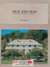 Eltham District Historical Society Inc
Book, Earthbuild, Mud and Man: a history of earth buildings in Australia by Ted Howard, 1992
Includes references to local sites Bear's Castle, Yan Yean (City of Whitlesea), mud brick houses in Eltham, including at Montsalvat and Eltham Community Centre, Smith's Gully, Plenty Baptist Church and Warrandyte. Includes chapter on Alistair Knox. The author's own home appears in the book on page 100. It was situated at Batman Road, Eltham next to the manse and church opposite Stanley Avenue. It was demolished for unit development June 2004 after the author's death in 2003. A significant and oft cited history of the mud brick earth construction style of architecture which includes a number of examples within the Shire of Nillumbik, known to be a site of the environmental earth building movement following WW2.198 p. : ill. (some col.), maps ISBN 0646069624earth construction, mud bricks, pise, domestic architecture -
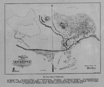 Federation University Historical Collection
Image, The First Map of Melbourne, 1837
Scanned from "The Old Pioneers' Memorial History of Melbourne From the Discovery of Port Phillip to the World War".First map of Melbourne showing the location of Batman's Hill, Batman's House, Lonsdale's Residence, Commissarist Stores, location of John Falwkner, R. Webb, D'Acry, Carr, Diprose, Nodin, Robson, Alex Thompson, Surveyors tents, Burial Hill (AKA Flagstaff Hill)port phillip bay, batman's hill, batman's house, lonsdale's residence, commissarist stores, john fawkner, r. webb, d'acry, carr, diprose, nodin, robson, alex thompson, surveyors tents, burial hill, flagstaff hill -
 Victorian Aboriginal Corporation for Languages
Book, Dawn A Lee, Daughter of two worlds, 2002
The biography of a Victorian Koori woman who traced her family lineage back to the first contact between Indigenous Victorians and the founder of Melbourne. Daughter of Two Worlds by Dawn Lee begins with a tragic affair between Eliza Batman, the wife of Melbourne pioneer John Batman, and William Willoughby, Batman's right-hand man and a pillar of Melbourne's early Wesleyan church. The book also unearths the remarkable truth behind a family legend that Dawn Lee's great grandfather was a mysterious white English lord who met her great grandmother, Susannah, a full tribal Gunditjmara woman.maps, b&w photographsgunditjmara, dawn a lee, aboriginal victorians, victorian history -
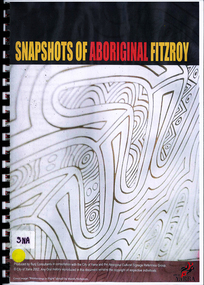 Victorian Aboriginal Corporation for Languages
Book, Bunj Consultants, Snapshots of Aboriginal Fitzroy, 2004
... Gardens MAYSAR Batman treaty oral histories maps, photographs ...Features artwork by VACL Project Officer Mandy Nicholson.maps, photographswurundjeri, carlton gardens, alexandria gardens, maysar, batman treaty, oral histories -
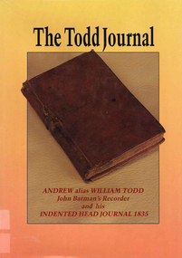 Victorian Aboriginal Corporation for Languages
Book, Philip L Brown, The Todd journal 1835 : Andrew alias William Todd (John Batman?s recorder) and his Indented Head journal 1835, 1989
Reproduction of the 1835 journal of Andrew/William Todd, recorder and assistant to John Batman, with numerous contemporary illustrations of early settlements and landscapes. Notes on the customs and many incidents with Victorian and Tasmanian Aborigines.maps, b&w illustrations, b&w photographsjohn batman, victorian history, andrew todd, william todd -
 Victorian Aboriginal Corporation for Languages
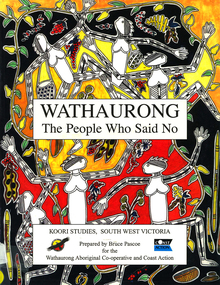
Book, Bruce Pascoe et al, Wathaurong : the people who said no, 2003
The Wathaurong people of South Western Victoria said no to European invasion. Learn about this heroic resistance to the occupation of their lands. Can white and black live together or must we be always at war? The answer can only be given by young Australians. Includes a comprehensive historical timeline.maps, colour illustrations, b&w illustrations, colour photographs, word listswathaurong, wadtharung, port philllip bay, western port bay, lorne, south west victoria, battle creek, aire river, werribee, ballarat, wathaurong aboriginal cooperative, coast action, koori studies, john batman, william buckley, aboriginal studies policy, secondary school education, hissing swan, victorian history -
 Victorian Aboriginal Corporation for Languages
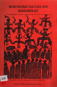
Book, Nillumbik Reconciliation Group, Wurundjeri culture and resource kit, 1999
Contains culture,history, time lines, cross word puzzles etc.maps, b&w photographs, b&w illustrations, games, word listswurundjeri, woiwurrung, woiworung, kulin, yarra valley history, wurundjeri-willam, boon wurrung, bunurong, wathaurong, kurrung, taungurung, taungurong, yarra yarra, william barak, john batman, coranderrk, nillumbik shire council -
 Victorian Aboriginal Corporation for Languages
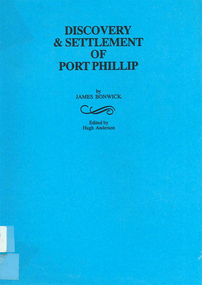
Book, James Bonwick, Discovery and settlement of Port Phillip : being a history of the country now called Victoria, up to the arrival of Mr. Superintendent Latrobe, in October, 1839, 1999
Contains a general history of the early Port Phillip district, including many references to Aboriginal peoples. Edited version of original 19th century notes by James Bonwick.Maps, b&w illustrationswilliam buckley, john batman, joseph gellibrand, john pascoe fawkner, victorian history, melbourne history, port phillip, religion, merri creek, james bonwick -
 Victorian Aboriginal Corporation for Languages
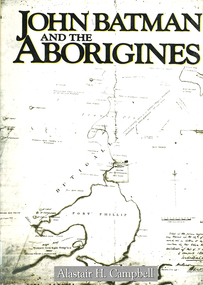
Book, Alastair H Campbell, John Batman and the Aborigines, 1987
... victorian history victorian indigenous history batman treaty maps, b ...A comprehensive account of John Batman's life. This is a broad social history of the life and contentions of the original Port Phillip settlement. It includes relations between the European colonists and the Aboriginal population. It shows how the initial Aboriginal policy lay the ground for the near genocide of Port Phillip's original inhabitants.maps, b&w illustrations, b&w photographsbunurong, boonwurrung, wathaurong, woiworung, woiwurrung, wurundjeri, wodewarrou, gerarlture, beingalite, you whamgete, you yangs, yarra river, kurung, john batman, port phillip bay, victorian history, victorian indigenous history, batman treaty -
 Victorian Aboriginal Corporation for Languages
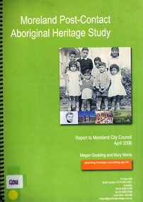
Book, Megan Goulding et al, Moreland post-contact Aboriginal heritage study, 2006
This study aims to identify Aboriginal heritage sites and landscape associations in the Moreland municipality that date from the pre-contact period through to the early contact period when Europeans settled in and around the area, to the present day.maps, colour photographs, b&w photographs, tableswoiworung, woi wurrung, wurundjeri, waa, bunjil, werribee river, port phillip, mount baw baw, great dividing range, yarra river, eastern kulin, gunung willam balluk, william barak, john batman, william thomas, moreland history, moieties, local history, colonisation -
 Victorian Aboriginal Corporation for Languages
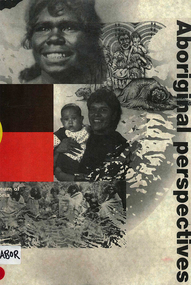
Book, Museum of Victoria Education Service, Aboriginal perspectives, 1996
The kit is designed for the general public, teachers and students, to give an understanding of Australian Indigenous people and culture and to break down stereotypes that are common in the school system and the wider community. The information presented is about the cultural, spiritual, economic and religious aspects of pre-contact societies. The impact of invasion on traditional societies and the post-colonial history of Australian Indigenous people is explored.Maps, b&w illustrations, b&w photographs, colour photographsculture, history, john batman, batman treaty, coranderrk mission, koorie culture, lake condah mission, kinship systems, aboriginal art, dreaming stories, kulin, gunai/kurnai, mara, wotjobaluk, wudjubaluk, koori -
 Koorie Heritage Trust
Book, Batman, John (See Victoriana series), The Settlement at Port Phillip, 1835, 1983
John Batman was born in New South Wales in 1801. With his brother, Henry, he moved to Van Diemen's Land in 1821. In 1824, John received a grant of 600 acres near Ben Lomond and in 1828 he married Eliza Thompson. Batman, with his friend J.H. Wedge and J.T. Gellibrand, determined on an expedition into New Holland. Motivated by Hume and Hovell's discoveries they applied for a grant of land at Western Port. This was refused, but in 1834 the ideas of the Port Phillip Association was discussed...56 p. : 1 folded map. ; 21 cm.John Batman was born in New South Wales in 1801. With his brother, Henry, he moved to Van Diemen's Land in 1821. In 1824, John received a grant of 600 acres near Ben Lomond and in 1828 he married Eliza Thompson. Batman, with his friend J.H. Wedge and J.T. Gellibrand, determined on an expedition into New Holland. Motivated by Hume and Hovell's discoveries they applied for a grant of land at Western Port. This was refused, but in 1834 the ideas of the Port Phillip Association was discussed...batman, john, 1801-1839. | victoria. settlement, 1835. batman, john, 1801-1839. correspondence, diaries, etc.. | pioneers -- victoria -- correspondence. | victoria -- history -- 1834-1851 -- sources. -
Koorie Heritage Trust
Book, Bonwick, James, Discovery and Settlement of Port Phillip; being a history of the country now called Victoria, up to the arrival of Mr. Superintendent Latrobe, in October, 1839 by James Bonwick; revised, at request, by W. Westgarth, 1856
Contents: Discovery of Port Phillip; First Settlement of Port Phillip; Abandonment of the Colony of Port Phillip; Further discoveries in the Country; Hume and Hovell's Overland Trip; Settlement of Western Port; Captain Sturt on the Murray; Major Mitchell's Australia Felix; The Successful Settlement of Port Phillip; Batman and Gellibrand's Application; Settlement of Portland Bay; Life of Batman; Batman's visit to Port Phillip; Fawkner's Yarra Settlement; Mr. Wedge's Narrative; William Buckley; The Association and Government; Progress of the Settlement; Flocks and Flock-masters; Government; Stewart, Simpson, Lonsdale, Latrobe; The Land and Land Sales; Law, Police and Port; Commerce, Trade and Shipping; Melbourne and Geelong; Hotels and Licences; Amusements; Rise and Progress of the Port Phillip Press; Religion in Port Phillip.142 p. : 1 fold-out map. ; 21 cm.Contents: Discovery of Port Phillip; First Settlement of Port Phillip; Abandonment of the Colony of Port Phillip; Further discoveries in the Country; Hume and Hovell's Overland Trip; Settlement of Western Port; Captain Sturt on the Murray; Major Mitchell's Australia Felix; The Successful Settlement of Port Phillip; Batman and Gellibrand's Application; Settlement of Portland Bay; Life of Batman; Batman's visit to Port Phillip; Fawkner's Yarra Settlement; Mr. Wedge's Narrative; William Buckley; The Association and Government; Progress of the Settlement; Flocks and Flock-masters; Government; Stewart, Simpson, Lonsdale, Latrobe; The Land and Land Sales; Law, Police and Port; Commerce, Trade and Shipping; Melbourne and Geelong; Hotels and Licences; Amusements; Rise and Progress of the Port Phillip Press; Religion in Port Phillip.victoria -- history -- to 1834. | victoria -- history -- 1834-1851. | melbourne (vic.) -- history -- to 1834. | melbourne (vic.) -- history -- 1834-1851. -
Koorie Heritage Trust
Book, Billot, C. P. (Cecil Philip), John Batman : the story of John Batman and the founding of Melbourne, 1979
Founder of Melbourne no biography since 1867, the manner of his death may be the reason. Documentary works from a variety of primary sources in State libraries and Public Records have assisted in this work.xiii, 330 p., 8 p. of plates : ill., maps, ports. ; 24 cm.Founder of Melbourne no biography since 1867, the manner of his death may be the reason. Documentary works from a variety of primary sources in State libraries and Public Records have assisted in this work.batman, john, 1801-1839. | victoria. port phillip bay region. settlement. batman, john, 1801-1939. biographies. | land settlement -- victoria -- port phillip bay district. | port phillip bay region (vic.) -- history. -
 Otway Districts Historical Society
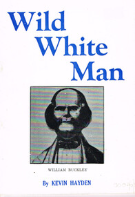
Book, Marine History Publication, Wild White Man
William Buckley was born in 1780 at Macclesfield, Cheshire, England. After time as a bricklayer and soldier he was caught with stolen property, sentenced on 2 August 1802, and transported to Australia. Between October, 1803, and January, 1804, he escaped from Sullivan's Bay in the Port Phillip district and spent the next 32 years in the company of aborigines wandering between Port Phillip and the near western district as far as Lake Corangamite. In about 1835 he was discovered by three white men, members of John Batman's Port Phillip Association investigating the area with a view to future settlement.Wild white man. Kevin Hayden. Marine History Publications; Geelong (Vic); nd. 28 p.; illus.; map. Soft cover.william buckley; aborigines; otway ranges; -
 Kew Historical Society Inc
Map, Robert Russell, Map Shewing the Site of Melbourne and the Position of the Huts & Buildings Previous to the Foundation of the Township by Sir Richard Bourke in 1837
Map shows the first layout of Melbourne by Government surveyor Robert Russell, who accompanied Governor Richard Bourke in 1837. The surveyed blocks extend from present-day Flinders Street to Lonsdale Street, and Spring Street to Spencer Street, with extensive vacant land west to a salt lake (afterwards Batman's Swamp, later drained), north beyond Flagstaff Hill and south towards South Melbourne. Vegetation coverage is indicated, and tracks and existing buildings and cultivated land are shown.Printed map was created by Day & Haghe, Lithographers to the Queen, sometime after 1838, when the company received its Royal appointment. Copies of the 1837 map exist in several major map collections in Australia; most are uncoloured. This particular map is the earliest in the Kew Historical Society's map collection. It is a nationally significant artefact. Black and white lithographed map hand-coloured in blue and yellow gouache of the town of Melbourne in 1837. In contrast to the original lithograph, the river and the township blocks are coloured blue and yellow. A similar, partly coloured copy is in the collection of the University of Melbourne.maps - melbourne - 1830s, governor sir richard bourke, robert russell - surveyor, cartography -
Kew Historical Society Inc
Book, Book Collectors' Society of Australia, Batman & Fawkner: Discovery of the River Yarra; an episode, 1965
Originally printed by H. Cordell, 59 Queen St., 1881. Limited edition of 250 copies11 p. 2 facsims. 23 cm. non-fictionOriginally printed by H. Cordell, 59 Queen St., 1881. Limited edition of 250 copiesbatman john -- 1801-1839, fawkner john pascoe -- 1792-1869, melbourne (vic.) - history - 1834-1851. -
 Kew Historical Society Inc
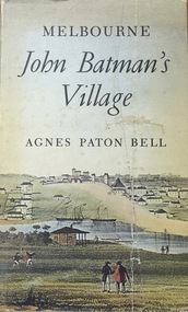
Book, Agnes P Bell, Melbourne: John Batman’s Village, 1965
A history of Melbourne, tracing its development from the riverside village founded by John Batman to the metropolis of the 1960s; includes description of Aboriginal corroborees and other early encounters with the Aboriginal inhabitants of the area.Melbourne, Vic. : Cassell Australia, 1965 xiv, 178p. : ill. (some col.), facsims., map, porto. ; 25cm. non-fictionA history of Melbourne, tracing its development from the riverside village founded by John Batman to the metropolis of the 1960s; includes description of Aboriginal corroborees and other early encounters with the Aboriginal inhabitants of the area.batman, john, 1801-1839, melbourne (vic.) -- history., settlement and contacts - colonisation - 1851- -
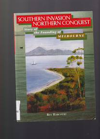 The Celtic Club
Book, Rex Harcourt, Southern invasion, northern conquest: Story of the founding of Melbourne, 2001
This book is an account of how exploration and settlement of Port Phillip paved the way for colonising present day Victoria.Index, bib, plates, maps, ill. p. 240.non-fictionThis book is an account of how exploration and settlement of Port Phillip paved the way for colonising present day Victoria.exploration and development - melbourne, john batman - melbourne - history -
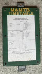 Melbourne Tram Museum
Functional object - Timetable Board, Melbourne & Metropolitan Tramways Board (MMTB), Camberwell Junction - Batman Ave, 1970s
... in the 1970s and early 1980s. tramways Map Batman Ave Camberwell ...Timetable board for Camberwell Junction Batman Ave route 70, detailing times that services were scheduled to depart the Junction. Probably used until replaced by The Met style signs in the mid-1980s.Demonstrates a timetable board style used by the MMTB in the 1970s and early 1980s.Board made up to display tramway timetables for attachment to a post comprising heavy galvanised steel backing sheet with two small channels either end, spot welded to the steel back, front painted in green with the letters "M&M.T.B" in yellow paint, perspex sheet at the front, secured by 6 Allen screws with nuts on rear, containing a typed timetable sheet - for Camberwell Junction for Batman Ave timetable - undated. tramways, map, batman ave, camberwell junction, route 70, timetable -
 Bendigo Military Museum
Photograph - A Section, 1st Topographic Survey Troop, Vung Tau, Vietnam, 1966
This is a set of 12 photographs of A Section, 1st Topographic Survey Troop taken from the 25th of May to the 12th of June 1966 during their deployment to Vung Tau, Vietnam. Led by OC CAPT Bob Skitch, the ten personnel from A Section 1st Topo Svy Tp and six personnel from supporting units were the first contingent from the Royal Australian Survey Corps deployed to provide topographic support to the Australian Task Force in Vietnam. They arrived in Saigon, Vietnam on the 10th of June 1966 enroute to the Australian Reinforcement Unit (ARU) “back beach” camp in Vung Tau. The ten RA Svy technical personnel from 1st Topo Svy Tp deployed were: WO2 David Christie, SGT Stan Campbell, SGT Dave King, CPL Jim Roberts, CPL Dennis Duquemin, CPL Des Ceruti, SPR Derek Chambers, SPR Brian Firns, SPR Joe O’Connor and SPR Ron Smith. External personnel deployed were: WO2 Snow Rollston from Northern Command Field Survey Unit, T/CPL Peter Clarke – orderly room corporal, T/CPL Alan Carew – Technical Storeman, SPR Stan Johns – Map Storeman, SPR Boots Campbell – batman/driver and PTE BNF Brunning – cook. The ship featured in photos .1P and .2P was the aircraft carrier HMAS Sydney on its 4th voyage to Vietnam. On board were SGT Stan Campbell and SPR Brian Firns, tasked to manage A Section’s stores and equipment. The rest of A Section deployed to Vietnam by air on the chartered Qantas 707B ‘City of Longreach'. A Section’s main tasks were to establish a Theatre Grid, map compilation and map revision; Engineer Survey Support in the camp and to the civil community; give assistance to the Cordon Search Missions by producing large scale plots from aerial photos with every house and fence etc plotted; and then reproduce these by silk screening usually, within a 24-hour period. RA Svy’s support concluded with the withdrawal of Australian troops from Vietnam in 1972. More information on the A Section, 1st Topographic Survey Troop and the Army Survey Regiment’s supporting role is provided in pages 89 to 94 of Valerie Lovejoy’s book 'Mapmakers of Fortuna – A history of the Army Survey Regiment’ ISBN: 0-646-42120-4.This is a set of 12 photographs of A Section, 1st Topographic Survey Troop (1st Topo Svy Tp), taken from the 25th of May to the 12th of June 1966 during their deployment to Vung Tau, Vietnam. The black and white photographs were printed on photographic paper and are part of the Army Survey Regiment’s Collection. The photographs were scanned at 300 dpi. .1) &.2) - Photo, black & white, 1966. HMAS Sydney departing Woolloomooloo wharf en-route to Vietnam. .3) - Photo, black & white, 1966. A Section 1 Topo Svy Tp relaxing in a bar before deployment. OC CAPT Bob Skitch in centre of photo. .4) - Photo, black & white, 1966. Unidentified A Section 1 Topo Svy Tp personnel and troops from other units relaxing in a bar before deployment. .5) - Photo, black & white, 1966. A Section 1 Topo Svy Tp personnel arrival by bus at Saigon (Tan Son Nhut) Airport. OC CAPT Bob Skitch 4th from right. .6) - Photo, black & white, 1966. A Section 1 Topo Svy Tp personnel boarding the USAF Hercules aircraft enroute from Saigon (Tan Son Nhut) Airport to Vung Tau Airfield. OC CAPT Bob Skitch on left. .7) - Photo, black & white, 1966. A Section 1 Topo Svy Tp personnel and troops from other units boarding the USAF Hercules aircraft enroute from Saigon (Tan Son Nhut) Airport to Vung Tau Airfield. .8) & .9) - Photo, black & white, 1966. A Section 1 Topo Svy Tp personnel arrive at the Australian Reinforcement Unit (ARU) “back beach” camp. .10) - Photo, black & white, 1966. A Section 1 Topo Svy Tp personnel in oppressive conditions work on map products. .11) - Photo, black & white, 1966. Group photo of A Section 1 Topo Svy Tp. OC CAPT Bob Skitch on far right. .12) - Photo, black & white, 1966. Group photo of A Section 1 Topo Svy Tp. OC CAPT Bob Skitch 3rd from right.Annotated with the photo set - ‘ DET 1 Topo Svy Tp Vung Tau 25 May to 12 of Jun 66’royal australian survey corps, rasvy, army survey regiment, army svy regt, fortuna, asr, 1st topographical survey troop -
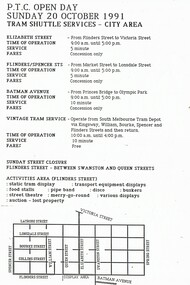 Melbourne Tram Museum
Souvenir - Event Materials, Public Transport Corporation (PTC), "PTC Open Day - 20 Oct. 1991 - Tram Shuttle Services - City Area", Oct. 1991
Event pamphlet - A4 photocopied sheet - advertising shuttle services and street closure for the "PTC Open Day - 20 Oct. 1991 - Tram Shuttle Services - City Area", locations, map, and fares and Activities in the Flinders St and Batman Ave. area.trams, tramways, ptc, events, open days, flinders st, batman ave -
 Melbourne Tram Museum
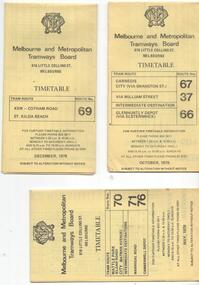
Ephemera - Timetable/s, Melbourne & Metropolitan Tramways Board (MMTB), "MMTB Tram Timetables", 1977 to 1978
Set of 6 MMTB Tram timetables, folded sheets, 8 sections, providing timetables for specific routes, day of week giving information on tram times at specific time points, route map, sections and fares and organisation address - 616 Little Collins St. Melbourne. All printed on yellow paper. 1. - Route 67, 37 and 66 - Carnegie - City via Swanston St (67), via William St (37) and Glenhuntly Depot (66) - dated Oct. 1978. .2 - Route 69 - Kew Cotham Road - St Kilda Beach dated Dec. 1978 .3 - Route 70, 71 and 76 - Wattle Park - Batman Ave, Arraign Road (Route 71) and Camberwell Depot (Route 76), dated May 1978 .4 - Route 72, 32 and 73 - Camberwell City via Swanston St (72), via William St (32) and Camberwell Junction (73) dated Sept, 1978. .5 - Route 82 - Moonee Ponds - Footscray - Highpoint West - dated Sept. 1977 .6 - Route 88, 14, 89 and 90, 96, 95 and 97 - East Preston via Bourke St (88), via Latrobe St (14), East Preston Bell St (89) and Northcote Dundas St (90) to the city and East Brunswick (96), Exhibition (95) and North Fitzroy (Park St), dated May 1978. .7 - Routes 48, 24, 40, 41, 29, 74, 76. 28 - July 1978 .8 - ditto - Weekends, July 1978, printed on green paper. .9 - Bus routes 284 (East Kew - Doncaster North) and 270 (East Kew - Shoppingtown) - dated August 1978trams, tramways, mmtb, timetables, melbourne, fares, route 14, route 32, route 37, route 66, route 67, route 69, route 70, route 71, route 72, route 73, route 76, route 82, route 88, route 89, route 90, route 95, route 96, route 97, route 48, route 24, route 40, route 41, route 29, route 74, route 76, route 28, route 284, route 270 -
 Melbourne Tram Museum
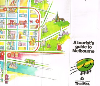
Pamphlet, The Met, "A tourist's guide to Melbourne", mid 1980's
Pamphlet, 14 fold printed in full colour on semi gloss paper, both sides. Gives a cartoon style map of the CBD, Melbourne suburbs and outer Melbourne, giving a list of places of interest and transport routes. Shows the vintage tram service along Batman Ave, Puffing Billy, Wattle Park, various precincts, shopping centres. Published by The Met, Metropolitan Transit and has the buzz logo on the front. Mid 1980's. Two copies heldtrams, tramways, maps, tourism, melbourne, wattle park, the met